MONTGOMERY COUNTY PLANNING DEPARTMENT THE MARYLAND NATIONAL CAPITAL PARK AND PLANNING COMMISSION
|
|
|
- Jeffery Leonard
- 5 years ago
- Views:
Transcription
1 MONTGOMERY COUNTY PLANNING DEPARTMENT THE MARYLAND NATIONAL CAPITAL PARK AND PLANNING COMMISSION MCPB Item No. 5 Date: 07/19/ Old Georgetown Road, Sketch Plan No Description Grace Bogdan, Planner Coordinator, Area 1, grace.bogdan@montgomeryplanning.org, Elza Hisel McCoy, Supervisor, Area 1, Elza.Hisel McCoy@montgomeryplanning.org, Robert Kronenberg, Chief, Area 1, Robert.Kronenberg@montgomeryplanning.org, Sketch Plan: Construction of a mixed use project of up to 228,000 total square feet, including up to 225,000 square feet of residential development, and up to 3,000 square feet of non residential uses; The maximum density includes up to 133,615 square feet of density from the Bethesda Overlay Zone (BOZ) with a Park Impact Payment (PIP); Current use: restaurant and surface parking lot; Located on the north corner of the intersection of Old Georgetown Road and Commerce Lane in Downtown Bethesda; 0.44 acres zoned CR 5.0 C 5.0 R 4.75 H 225, in the 2017 Bethesda Downtown Sector Plan; Applicant: Washington Property Company Completed: 07/06/18 Summary Staff recommends Approval of the 7607 Old Georgetown Road Sketch Plan, with conditions. The project will redevelop the existing site which contains a one story restaurant and surface parking with a new 225 foot tall mixed use building of up to 200 units and ground floor retail. The project includes an allocation of Bethesda Overlay Zone density of up to 133,615 square feet and a Park Impact Payment. The proposal includes 15% moderately priced dwelling units, minimum parking, structured parking, vegetated roof, and exceptional design, among other public benefits.
2 TABLE OF CONTENTS SECTION 1: RECOMMENDATION AND CONDITIONS 3 SECTION 2: SITE DESCRIPTION 6 Site Vicinity and Analysis SECTION 3: PROJECT DESCRIPTION 8 Proposal Uses and Density Buildings Open Space Environment Transportation SECTION 4: SKETCH PLAN ANALYSIS AND FINDINGS 12 SECTION 5: COMMUNITY OUTREACH 20 2
3 SECTION 1: RECOMMENDATIONS AND CONDITIONS Staff recommends approval of the 7607 Old Georgetown Road Sketch Plan No , for a mixed-use building of up 228,000 total square feet, including up to 225,000 square feet of residential development, and up to 3,000 square feet of non-residential uses on 0.44 acres, zoned CR 5.0 C 5.0 R 4.75, H-225, in the 2017 Bethesda Downtown Sector Plan. The maximum density includes up to 133,615 square feet of density from the Bethesda Overlay Zone (BOZ) with a Park Impact Payment (PIP). The following site development elements shown on the Sketch Plan stamped Received by the M-NCPPC on April 23, 2018, are binding under Section F: 1. Maximum density and height; 2. Approximate location of lots and public dedications; 3. General location and extent of public open space; 4. General location of vehicular access points; and 5. Public benefit schedule. All other elements of the Sketch Plan are illustrative and subject to refinement at the time of Site Plan. This approval is subject to the following conditions: 1. Density The Sketch Plan is limited to a maximum of 228,000 total square feet, including up to 225,000 square feet of residential development and up to 3,000 square feet of non-residential uses. The maximum number of dwelling units and use mix will be determined at Preliminary Plan. The maximum density includes up to 133,615 square feet of density from the Bethesda Overlay Zone (BOZ) with a Park Impact Payment (PIP). The final square footage will be determined at Site Plan. 2. Height The development is limited to a maximum height of 225 feet, as measured from the building height measuring point illustrated on the Certified Site Plan. 3. Incentive Density The development must be constructed with the public benefits listed below, unless modifications are made under Section I. and this Sketch Plan is amended. Total points must equal at least 100 and be chosen from at least four categories as required by Section A.2. The requirements of Division and the CR Zone Incentive Density Implementation Guidelines must be fulfilled for each public benefit. Final points will be established at Site Plan approval. a. Major Public Facilities, achieved through providing an offsite bikeshare station. This location must be accepted by both the Montgomery County Department of Transportation and the M-NCPPC. b. Connectivity and Mobility, achieved by providing fewer than the maximum parking spaces under the Zoning Ordinance and BOZ overlay, and trip mitigation that exceeds the required minimums; c. Diversity of uses and activities, achieved by providing small business opportunities; d. Quality of Building and Site Design, achieved through architectural elevations, exceptional design, structured parking, and a tower step-back; and e. Protection and Enhancement of the Natural Environment, achieved through building lot terminations and energy conservation and generation by incorporating materials and systems that exceed the required minimums. 3
4 4. Building & Site Design Prior to the submittal of the Site Plan, the Applicant must: a. Provide a minimum 12-foot building setback on Commerce Lane and 20- foot building setback on Old Georgetown from the curb to nearest point of the building façade including overhangs, cantilevers, or other building architectural elements/ features; b. Coordinate with appropriate agencies to remove above-grade signal boxes and other utility obstructions from the pedestrian way; c. Coordinate with appropriate agencies to provide additional pedestrian area and to enhance traffic safety at the northeast corner of Old Georgetown Road and Commerce Lane, such as through chamfering building and/or reducing curb radius. 5. Park Impact Payment (PIP) The Park Impact Payment (PIP) must be paid to the M-NCPPC prior to the release of the first above-grade building permit. The final amount will be determined at Site Plan. 6. Streetscape The Applicant must install the Bethesda Streetscape Standard along the Site Frontage. 7. Building Lot Terminations (BLTs) Prior to release of any building permit, the Applicant must provide proof of purchase and/or payment for the required BLTs. 8. Moderately Priced Dwelling Units (MPDUs) The Applicant must provide on-site a minimum of 15% of the total units as Moderately Priced Dwelling Units. The development must provide MPDUs in accordance with Chapter 25A. 9. Bicycle Facilities The Applicant must participate with the Montgomery County Department of Transportation to implement the master planned separated bicycle lanes along the Project s Old Georgetown Road frontage, details of which will be evaluated at Preliminary Plan. 10. MCDOT letter The Planning Board accepts the recommendations of the Montgomery County Department of Transportation ( MCDOT ) in its letter dated June 21, 2018 and hereby incorporates them as conditions of the Sketch Plan approval. The Applicant must comply with each of the recommendations as set forth in the letter, which may be amended by MCDOT provided that the amendments do not conflict with other conditions of the Sketch Plan approval. 11. Future Coordination for Preliminary and Site Plan In addition to any other requirements for Preliminary Plans under Chapter 50 and Site Plans under Chapter 59, the following must be addressed when filing a Preliminary or Site Plan, as appropriate: a. Fire and Rescue access and facility details; b. Streetscape details; c. Necessary public right-of-way dedication; d. Demonstrate how each public benefit satisfies the Zoning Ordinance and Incentive Density Implementation Guideline requirements; e. Study alternatives for the proposed cantilever at Commerce Lane, submit street level perspectives with Site Plan showing impact of any cantilever into the pedestrian realm; 4
5 f. Explore pedestrian access entrances into Bethesda Place Plaza in coordination with adjacent Property Owner(s); g. Explore provision of a minimum of two street trees on each ROW frontage per the Streetscape Standards and Design Guidelines and provide appropriate clearance for canopy to mature without significant obstruction from building overhangs; h. Submit a site distance analysis at time of Site Plan to determine if tree placement will obstruct views from loading and garage entrance; i. Further develop circulation and loading strategy to reduce visual impacts along Commerce Lane; j. Traffic Mitigation Agreement to participate in the Bethesda Transportation Demand Management District and exceed the Sector Plan 55% NADMS goal; k. Address the SITES & LEED recommendations of the Sector Plan, specifically related to energy efficiency and building design features; l. SWM concept approval (and subsequent plan) which also address the Bethesda Downtown Sector Plan recommendations regarding SWM; m. At the time of Site Plan, the Applicant must show 35% of net lot area of intensive green roof (or onsite canopy plantings) to meet 35% green cover requirement for the site as described in Section Urban Green (page 60) of the Master Plan and Section of the associated Design Guidelines (page 63); n. Address Bird-Safe Design per pages of Bethesda Downtown Sector Plan Design Guidelines; o. Provide a noise analysis at time of Preliminary Plan, or a waiver may be submitted per Section of the 1983 Noise Guidelines. 5

6 SECTION 2: SITE DESCRIPTION Site Vicinity and Analysis Vicinity The surrounding properties are generally mixed-use with Bethesda Place apartments and former Safeway on the ground level to the northeast, the Metropolitan apartments with first-floor retail to the southwest across Old Georgetown Road, Element 28 apartments to the southeast opposite Commerce, and Bethesda Place Development to the north and northwest that consists of two commercial buildings and a common open space interior to the block furnished with artistic amenities and shops. Pedestrians can access this space from Wisconsin Avenue, Commerce Place, Woodmont Avenue, and a pedestrian bridge that connects to 7600 Old Georgetown Road. In the larger vicinity there are several projects currently under review or recently approved, such as the 4 Bethesda Metro Center Sketch Plan that proposes the redevelopment of a three-story building and Metro Plaza area, as well as a mixed-use building with ground floor retail and either residential or office above. To the southwest, Edgemont II Sketch Plan and Preliminary Plan amendment was recently approved for an addition to the existing residential building to allow up to 282 units (122 existing units). ZOM Sketch Plan was approved for up to 235 residential units and is under review for Preliminary and Site Plans. To the north of the Property is the Marriott Headquarter s site which was recently approved for Sketch, Preliminary, and Site Plans to allow a mixed use commercial development including office space and a new 246 room hotel. Figure 1: Vicinity Map 6
. The Property has a tract area of 0.44 acres, is located within 500 feet of the Bethesda Metro Station, and falls within the Bethesda Parking Lot District (PLD).")
7 Subject Property The subject site (Subject Property or Property) is located at the corner of Old Georgetown Road and Commerce Lane in the Wisconsin Avenue District of the 2017 Bethesda Downtown Sector Plan (Sector Plan). The Property has a tract area of 0.44 acres, is located within 500 feet of the Bethesda Metro Station, and falls within the Bethesda Parking Lot District (PLD). Figure 2: Boundary Map Site Analysis The Property is zoned CR 5.0, C 5.0, R 4.75, H 225 and currently developed as a single-story restaurant and parking lot. The Property fronts on Old Georgetown Road and Commerce Lane. This section of Old Georgetown Road contains three lanes of one-way northbound traffic and one lane of on-street parking on the south side of the street. Commerce Lane is a two-way street with no on-street parking and connects to Wisconsin Ave. The Property does not contain any forest, streams, or environmental buffers. There are no known rare, threatened, or endangered species on-site; there are no 100-year floodplains, stream buffers, or wetlands on-site. There are no historic properties on-site. 7
.")
8 SECTION 3: PROJECT DESCRIPTION Proposal The Applicant proposes to redevelop the Property with a new 225-foot-tall mixed-use building totaling 228,000 square feet, including 225,000 square feet of residential development and 3,000 square feet of retail. The Project also includes 15% Moderately Priced Dwelling Units (MPDU s). The Project includes an allocation of density from the Bethesda Overlay Zone of up to 133,615 square feet. The final amount of density to be purchased from the BOZ, which will require a Park Impact Payment (PIP), will be determined at Site Plan where final density for the entire Project will be reviewed. Figure 3: Proposed Sketch Plan Building The building design works to maximize the buildable area of the site while addressing the Sector Plan Design Guidelines. The lobby and retail space will engage the corner of Old Georgetown Road and Commerce Lane, which is recommended as a retail node in the Guidelines. As proposed, the building will back up to Bethesda Place Plaza at the rear and will cantilever over the pedestrian realm on Commerce Lane, within the Property boundaries, approximately eight feet. As the building increases in height, the structure steps back along both frontages into two distinct towers. 8


9 Figure 4: Building Section The design proposes a three volume composition to include a street scale base with two volume towers of varying heights resulting in a distinct profile in the Bethesda cityscape. Above the ground floor, the base cantilevers over the pedestrian realm along Commerce Lane. The size of the cantilever has the potential to encroach into the pedestrian realm and conflict with street tree placement and tree growth. The recently constructed Element 28 apartment building across Commerce Lane has a similar cantilever and conflict between the building and street tree growth is already noticeable. After the base, the building proposes to stepback into two towers and the rooftop will contain a green roof, residential amenities, and a mechanical penthouse. Figure 5: Massing Diagram 9
10 Open Space With a tract area of less than 0.50 acres, the Applicant is not required to provide public open space on-site. As mentioned above, the Applicant is pursuing a pedestrian connection to the Bethesda Place Plaza (Public Open Space). Environment Forest Conservation Since the approval of the recent amendments to the Forest Conservation Law, all properties seeking approval of a Sketch Plan after February 26, 2018 must obtain approval of a Natural Resources Inventory/Forest Stand Delineation (NRI/FSD) or forest conservation exemption prior to the Planning Board acting on the Sketch Plan. Staff confirmed a Forest Conservation Exemption for this project on January 19, 2018, through Section 22A-5(s)(1) of the Forest Conservation Law under application # E. The project qualifies for the small property exemption because the net tract area is less than 1.5 acres with no existing forest or existing specimen or champion trees, and the afforestation requirements would not exceed 10,000 square feet. Stormwater Management (SWM) A Stormwater Management Concept Plan is not required at the time of Sketch Plan. Submission of the concept to the Department of Permitting Services (DPS) and approval will be required at the time of Preliminary Plan. The ultimate SWM plan approval should also address the Bethesda Downtown Sector Plan recommendations regarding SWM. Green Cover The Sector Plan includes a number of recommendations to achieve the urban green goals. An important recommendation to this effect is the onsite 35% green coverage minimum. The green cover may include singularly or a combination of intensive green roof (6 inches or deeper) or tree canopy cover. The proposed layout of the building precludes the opportunity for onsite canopy tree plantings. Therefore, the onsite 35% green cover will need to be achieved entirely through the use of intensive green roof. The green cover exhibit submitted by the applicant shows a net lot area of 13,777 sf, and a resulting green coverage requirement of at least 4,822 sf (35% of net lot area). However, the exhibit shows only 4,150 sf of proposed green roof which is 672 sf short of the 35% minimum. Staff notes the exhibit includes 730 sf of microbio retention planter (in addition to the green roof) as completing the green area requirements. However, the proposed micro-bio retention planter does not meet the green cover definitions established by the Sector Plan. Therefore, Staff has recommended a condition of approval to appropriately achieve the 35% minimum coverage without the micro-bio retention area. Transportation Access and Circulation Pedestrian access to the site will be from the established sidewalk network and will be enhanced by streetscape improvements along each of the Site frontages, consistent with the Bethesda Streetscape Standards. The existing signal pole and utility cabinet for the Old Georgetown Road and Commerce Lane intersection are located within the right-of-way at this corner, very close to the Property boundary. This space is further reduced by a wide curb radius, resulting in a less than desirable circulation pattern for pedestrians. As conditioned, the Applicant will coordinate with appropriate public agencies to relocate and otherwise modify the sidewalk to improve pedestrian access. 10
 and minimizes interuptions to the pedestrian realm.")
11 Vehicular access to the Property is proposed directly from Commerce Lane through a consolidated garage access point and loading bay (two separate but adjacent entrances) at the northeast corner of the site. This configuration eliminates vehicular access from Old Georgetown Road (MD 187) and minimizes interuptions to the pedestrian realm. Resident vehicle parking is proposed to be contained within a structured below-grade garage, with the final quantity of parking spaces and ingress/ egress into the parking structure determined at Site Plan based on the final number of residential dwelling units. Pedestrian and bicycle access to the Property will be provided along both Commerce Lane and Old Georgetown Road, though pedestrian and bicycle access will be prioritized along the Old Georgetown Road frontage through the residential lobby, bicycle parking and room (Figure 6). Master planned separated bicycle lanes are anticipated along the north side (subject property) of Old Georgetown Road. The Applicant s participation in the implementation of this facility will be determined at the time of Preliminary Plan review. Figure 6: Vehicular & Pedestrian Circulation Transit Connectivity The immediate area is well served by transit that includes the Red Line Bethesda Metrorail Station (located approximatey 500-feet feet to the southeast), Metrobus, RideOn, the Bethesda Circulator and future Purple Line and BRT. 11
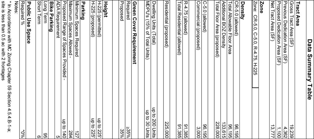
12 Master Plan Roadways and Pedestrian/Bikeway Facilities The 2017 Bethesda Downtown Sector Plan recommends the following along property frontages: 1. Old Georgetown Road, along the southwestern site frontage, as a major highway (M-4) with a minimum right-of-way width of 80 feet and separated bicycle lanes (CT-8). Although a specific deisgn for the Old Georgetown Road separated bike lanes has not yet been determined, the current concept envisions this bicycle facility on the north side of Old Georgetown Road. Staff believes the north side of the roadway will better coordinate with plans for the East-West Highway (MD 410) separated bikeway which are also envisioned on the north side. 2. Commerce Lane, along the eastern site frontage, as a business district street with a minimum right-of-way width of 50 feet and bicycle shared roadway (SR-8). Sector-Planned Transportation Demand Management The Sector Plan encourages a Non-Auto Driver Mode Share (NADMS) of 55%, averaged between employees and residents of Downtown Bethesda. In order to meet this goal, Downtown Bethesda is organized into a Transportation Demand Management District (TMD) that strives to promote travel by means other than single occupancy vehicles. As a residential project of more than 100 dwelling units within the Bethesda TMD, the development is required to enter into a Traffic Mitigation Agreement (TMAg) with the Planning Board and Montgomery County Department of Transportation (MCDOT) to participate in the Bethesda TMD. Specific details of the TMAg will be determined during the Preliminary Plan review. Adequate Public Facilities The Project is estimated to generate 108 morning peak-hour person trips and 120 evening peak-hour trips. When compared to the existing use to be removed from the Site, the Project generates a net new four morning peakhour person trips and 18 evening peak-hour trips. Since the Project will generate fewer than 50 net new person trips, the Local Area Transportation Review will be satisfied with a transportation statement. SECTION 4: PROJECT ANALYSIS AND FINDINGS The purpose of a Sketch Plan is to identify general land uses, development intensity, and public benefits for the optional method of development in the CR, CRT, EOF or LSC zones. The Sketch Plan is intended to be conceptual in nature with an emphasis on building densities, massing, heights and anticipated uses, the locations of open and public use spaces, the general circulation patterns for all modes of transportation, an estimated range of peak hour trips and relationships between existing or proposed adjacent buildings and rights-of-way. Details of the proposed development are determined during Preliminary and Site Plan review. Section E of the Zoning Ordinance states: To approve a Sketch Plan the Planning Board must find that the following elements are appropriate in concept and appropriate for further detailed review at Site Plan. The Sketch Plan must: 1. Meet the objectives, general requirements, and standards of this Chapter; The Sketch Plan meets the development standards of Section , as shown in the following Data Table: 12
13 Section 59.4 Sketch Plan Data Table Development Standard Permitted/ Required Proposed Tract Area per Zone CR 5.0 C-5.0 R-4.75 H-225 n/a 19,239 sf (0.44 ac) Prior Dedication n/a 4,362 sf (0.10 ac) Proposed Dedication n/a 1,100 sf (0.02 ac) Site Area n/a 13,777 sf (0.32 ac) Residential Density (GFA/ FAR) 91,385 sf (4.75) 91,385 sf (4.75) Commercial Density (GFA/FAR) 96,195 sf (5) 3,000 sf (0.16) Bethesda Overlay Zone Density n/a 133,615 sf (6.94) Total FAR/GFA n/a 228,000 sf (11.85) Building Height CR 5.0 C-5.0 R-4.75 H feet 225 feet Public Open Space (min) 0 0 Minimum Setbacks 0 0 The Application will provide the minimum required number of bicycle parking spaces within the building, which will be determined at the time of Site Plan. The final number of vehicular parking spaces will be determined at Site Plan based on the residential units and retail square footage. The Sketch Plan conforms to the intent of the CR zone as described below: a) Implement the recommendations of applicable master plans. The Project substantially conforms to the recommendations for the Property included in the 2017 Bethesda Downtown Sector Plan. Specifically, this Sector Plan builds on the past successes of Downtown Bethesda to create a truly sustainable downtown by focusing on components that will bolster the elements most in need of enhancement. The recommendations increase: 1. Parks and open spaces, including new civic greens at Veteran s Park, Bethesda Farm Women s Cooperative Market, Capital Crescent Trail and new urban parks, pathways and gateways. 2. Affordable housing, including the preservation of existing market-rate affordable housing, providing a mix of housing options and the provision of Moderately Priced Dwelling Units in exchange for development incentives. 3. Environmental innovation, including more energy-efficient buildings, better stormwater management, improved sidewalks and bicycle routes, and other measures to enhance community health and quality of life. 4. Economic competitiveness, based on new development, public amenities and proximity to public transit to attract businesses and visitors from throughout the region, and foster entrepreneurship and innovation. The Property is designated as site 70 on page 100 of the Sector Plan. The Property is in the Wisconsin Avenue Corridor District. The Wisconsin Avenue Corridor is the main artery through the center of Downtown Bethesda. With the existing Bethesda Metrorail Station, future Purple Line and bus rapid 13
14 transit (BRT) options, Wisconsin Avenue is a critical focus area for improved access, mobility and pedestrian safety. The corridor is envisioned as a symbolic downtown center that reflects the character of adjacent neighborhoods and overall identity of Bethesda through innovative building designs and active public spaces. Specifically, the Project addresses the following goals as outlined in the Overarching Goals and Wisconsin Avenue Corridor sections of the Sector Plan: Encourage infill and reinvestment on underutilized commercial sites and private surface parking lots. The Project provides an opportunity for infill development of an underdeveloped commercial site within a block of the Metro station, as recommended by the Sector Plan, by converting a single-story commercial building and surface parking lot to a mixed-use Project with up to 200 multi-family dwelling units and up to 3,000 square feet of retail. Encourage mixed-income/affordable housing near transit stations. The Project will provide residential dwelling units within a block of the Metro station in an area dominated by commercial an office uses. The project would provide much needed affordable housing in the form of additional MPDUs. The 15 percent MPDUs will result in up to 30 additional MPDUs in Downtown Bethesda. This proposed influx of MPDUs will help to further one of the primary goals of the Sector Plan and Bethesda Overlay Zone thereby ensuring that affordable housing opportunities exist in transit-oriented locations. Develop compact nodes that place the highest intensity in those centers, provide distinctive infill buildings and step down to lower densities and heights near the edges. The Project will place high density residential uses and street activating retail uses in the core of Downtown Bethesda, incorporating urban design elements that provide visual interest further defining the skyline in the Wisconsin Avenue Corridor District. Economic competitiveness based on new development, public amenities and proximity to public transit to attract businesses and visitors from throughout the region, and foster entrepreneurship and innovation. The Project will provide infill redevelopment within the highest intensity center in Downtown Bethesda which is dominated by office buildings and retail that serves the office customer base. The project will provide an influx of residents to the Metro Core area providing much needed around-the-clock activity contributing to a more vibrant mixed-use identity. The combination of multifamily dwelling units, ground floor retail uses, and amenities proposed will increase the customer base of nearby shops, restaurants and services in the Metro Core during nighttime and on weekends that does not exist today. Encourage high-performance buildings and sites nearest the established centers. The Project proposes to incorporate energy efficient building systems to exceed the ASHRAE 90.1 standard by a minimum of 17.5%, as required by the Bethesda Overlay Zone. In addition, intensive green roof systems are proposed to maximize the Property s overall green cover. 14
15 The design of the Project generally conforms to the Sector Plan Design Guidelines with the exception of two components. The Guidelines recommend a Build-To Line along Urban Boulevards such as Old Georgetown Road. While the project only proposes a 20 foot setback at this time, the building setback responds to the existing development along the street on either side of the Property and will contribute to a continuous street wall. The Design Guidelines also call for a Build-To Line along Downtown Mixed Use Streets, such as Commerce Lane. The proposal allows for a 15 setback for the ground floor of the project along Commerce Lane, however a proposed second-story cantilever of approximately 8 will encroach into the recommended Build-To Line and pedestrian realm. Page 72, Section of the Bethesda Design Guidelines states Avoid cantilevering the majority of the building mass over the Frontage Zone, public sidewalk, or public open space to prevent interfering with street trees and blocking access to sunlight and sky views for pedestrians. As a uniquely shaped and undersized lot, Staff acknowledges the site is constrained. However, a cantilever of this size would negatively impact the pedestrian realm and increase conflicts with the existing signal pole and cabinet at the corner of Old Georgetown and Commerce Lane. Given that Commerce Lane is designated as a canopy corridor, this also raises potential conflicts with street tree placement and development potential. Staff recommends a condition that would require a minimum 12-foot setback on Commerce Lane and 20-foot setback on Old Georgetown from the curb to nearest point of the building façade including overhangs, cantilevers, or other building architectural elements/ features. b) Target opportunities for redevelopment of single-use commercial areas and surface parking lots with a mix of uses. The Project will redevelop the existing single-use lot that contains a single-story restaurant and private parking lot to build a mixed-use building that will house high density residential and allow for ground floor retail, all within proximity to the Metro. The Project meets the objective of this finding. c) Encourage development that integrates a combination of housing types, mobility options, commercial services, and public facilities and amenities, where parking is prohibited between the building and the street. The Project encourages such development by proposing market-rate residential units in a variety of unit types as well as 15% MPDUs, offering housing opportunities for a range of incomes proximate to the numerous transit options of Downtown Bethesda. The Project will accommodate all modes of transit pedestrian, bicycle, and vehicular in proximity to the Metro and bus service by improving the streetscape along its two frontages. The Project does not propose any parking between the building and the street frontages. d) Allows a flexible mix of uses, densities, and building heights appropriate to various settings to ensure compatible relationships with adjoining neighborhoods. The Sector Plan identifies the Wisconsin Ave District as an area that should emphasize mixed land uses that focus on employment, high density residential, and distinctive infill buildings. The Project will provide residential uses on-site as well as a height and density that is compatible with the desired character of infill development within the Wisconsin Ave District. 15
16 e) Integrate an appropriate balance of employment and housing opportunities. The Subject Property is within the Wisconsin Ave District of the Sector Plan, which is intended primarily for the mix of land uses and a focus on integrating residential in an area that is largely dominated by commercial and office. As proposed, the mixed-use project containing high density residential and retail provides the appropriate land use, as recommended in the Sector Plan. f) Standardize optional method development by establishing minimum requirements for the provision of public benefits that will support and accommodate density above the standard Method limit. The Project will provide the required public benefits from a minimum of four categories to achieve the desired incentive density above the standard method limit. Final determination of public benefit points will be determined at the time of Site Plan. The Bethesda Overlay Zone (BOZ) was adopted July 18, 2017, specifically to implement the recommendations of the Bethesda Downtown Sector Plan as it relates to density, building heights, affordable housing, parks, and design. The BOZ set a cap of overall development (32.4 million square feet) whereby the zoning approved for most properties retains the base density but increases the heights on respective sites. An Applicant can request an allocation of density over the base density to build to the maximum height permitted by the Zone, as needed. An allocation of density from the BOZ requires a park impact payment of $10/square foot based upon the density requested and facilitates acquisition of parkland in the downtown Bethesda area. This Application is requesting an allocation of 133,615 square feet from the BOZ initiating a Park Impact Payment (amount to be determined during Site Plan review) to be paid at the time of building permit. The amount of density allocated from the BOZ for Application is deducted from the 32.4 million cap. 2. Substantially conform with the recommendations of the applicable master plan; As discussed in Finding 1.a above, the Project substantially conforms to the recommendation of the 2017 Bethesda Downtown Sector Plan. The Project will provide a mixed-use building with ground floor retail in an Established Center of Activity within the Wisconsin Avenue District, increase the supply of housing to serve a variety of income levels, redevelop an underutilized property, and provide streetscape improvements that improve the safety and character of Old Georgetown Road and Commerce Lane. 3. Satisfy any development plan or schematic development plan in effect on October 29, 2014; The Sketch Plan is not subject to a development plan or schematic development plan. 4. Achieve compatible internal and external relationships between existing and pending nearby development; At 225 in height, the building will be taller than the surrounding existing buildings, as this is one of the few sites in the vicinity to redevelop under the Bethesda Downtown Sector Plan which allows for increased building height. The proposed massing also provides setbacks as recommended by the Bethesda Design Guidelines to ensure compatibility with existing buildings and public open space. The Applicant has stated in their Statement of Justification that they are coordinating with the adjacent property owners of Bethesda Place Plaza to allow access from the rear of the building into the public space. Additionally, the future building and site design has been conditioned to pursue this coordination to achieve an external relationship with the existing public open space. 16
17 5. Provides satisfactory general vehicular, pedestrian, and bicyclist access, circulation, parking, and loading: The Project provides satisfactory general vehicular, pedestrian, and bicyclist access, circulation, parking, and loading. Vehicular access and loading will be located along Commerce Lane to avoid traffic congestion along Old Georgetown Road. The Project has been conditioned to coordinate with MCDOT to participate in the future construction of separated bicycle lanes along the north side of Old Georgetown Road. Additionally, the Project will provide an offsite bikeshare station as part of their Public Benefit package, onsite bicycle storage for tenants, and underground parking for residents and the retail tenant. The Project is located within the Parking Lot District and as such, is providing less parking than the maximum required by zoning. Pedestrian access to the site will be from the established sidewalk network and will be enhanced by streetscape improvements along each of the Property frontages and right-of-way dedication along Old Georgetown Road as recommended by the Bethesda Design Guidelines. The current configuration of the Old Georgetown Road and Commerce Lane intersection presents conflicts in regards to pedestrian access due to existing obstructions such as the signal pole and above-grade utility box. Staff has conditioned the Project to coordinate with appropriate agencies during subsequent reviews to seek remedies such as relocating the signal pole, undergrounding the signal box, and/or modifying the curb radius. 6. Propose an outline of public benefits that supports the requested incentive density and is appropriate for the specific community; Taking into account the considerations in Section B and the Public Benefit Points established with the Bethesda Overlay Zone in Section C.4, including the recommendations and objectives of the Sector Plan and any applicable design guidelines, the Incentive Density Implementation Guidelines, the size and configuration of the site and its relationship to adjacent properties, similar public benefits nearby, and additional enhancements related to the individual public benefits, the following outline of public benefits supports the Applicant s request for incentive density and is appropriate for the community surrounding the site, as described below. For the proposed development, the Zoning Ordinance requires 100 points in four categories; however the Applicant has provided five categories for consideration. Although at the time of Sketch Plan review only the categories need be approved, the following table shows both the categories and points for the public benefits requested at Sketch Plan to demonstrate the project s ability to meet the requirement to provide sufficient benefit points. 17
18 Public Benefits Calculations Public Benefit Incentive Density Points Max Allowed Requested A: Major Public Facilities Bikeshare C: Connectivity and Mobility Minimum Parking Trip Mitigation D: Diversity of Uses and Activities Small Business Opportunities E: Quality of Building and Site Design Architectural Elevations Exceptional Design Structured Parking Tower Step-Back F: Protection and Enhancement of the Natural Environment Building Lot Termination (BLT) Energy conservation and generation TOTAL Denotes Sector Plan priority Major Public Facilities Bikeshare station: The Applicant requests 9 points for providing an off-site 19-dock bikeshare station. Points for this incentive are granted based on the amount of land conveyed to, actual construction of, or financial contributions made to major public facilities. Location of the offsite bikeshare station will need to be identified at Site Plan. Connectivity and Mobility Minimum Parking: The Applicant requests points for providing fewer than the maximum allowed number of parking spaces. Points for this incentive are granted on a sliding scale from no points for providing maximum allowable number of on-site spaces to 20 points for providing no more than the minimum numbers of spaces on-site. Final determination will be made at Site Plan. Staff supports the category at this time. Trip Mitigation: The Applicant requests 10 points for executing a binding traffic mitigation agreement (TMAg) with MNCPPC and MCDOT prior to certification of a Site Plan Application for the Project. Points for this incentive are granted for entering into binding agreements to reduce the number of weekday morning and evening peak hour trips attributable to the site in excess of any other regulatory requirement. The Public Benefits Section of the ordinance requires a minimum of 50% reduction, however the Bethesda Downtown Sector Plan recommends a reduction of trips by 55%. Points are given when the Project exceeds regulatory requirements, details will be determined during the Preliminary Plan review. Staff supports the category at this time. Diversity of Uses and Activities Small Business Opportunities: The Applicant requests 10 points for providing retail space for small businesses. Points for this incentive are granted when the project will be designed for small, 18
19 neighborhood-oriented businesses and the Applicant records covenants that reflects restrictions. One ground floor retail bay of 3,000 square feet is currently proposed. Staff supports the category at this time. Quality of Building and Site Design Architectural Elevations: The Applicant requests 30 points for providing architectural elevations as part of the Certified Site Plan showing particular elements of the design such as minimum amounts of transparency, maximum separation between doors, and other design priorities of the applicable Sector Plan and implementing design guidelines. The Sketch Plan is intended to be conceptual in nature with an emphasis on building densities, massing, and heights. Staff supports the category at this time with further details and refinement to be provided at the time of Site Plan. Exceptional Design: The Applicant requests 30 points for building and/or site design that enhances the character of a setting. As a site receiving an allocation of Bethesda Overlay Zone density, the Project is subject to the Design Advisory Panel review, which will award points based on the quality of the design. The Applicant asserts that the Project fulfills many recommendations of the Bethesda Downtown Sector Plan and Design Guidelines. The proposed massing is inspired by the unique trapezoidal shape of the Property and provides a distinct base with two towers that are stepped back and angled in response to the conditions of each frontage. The Applicant s Statement of Justification envisions a design that is sustainable in form and material, and sustainable in practice with use of rain screen technologies and mechanical systems. The construction materials are intended to be a combination of metal or ceramic panels, and masonry or concrete panels that will create a simple pattern that compliments the overall building form. Based on the conceptual materials submitted with the Application, Staff supports the category at this time. The Design Advisory Panel recommended the following during their April 4, 2018 meeting: - Public Benefit Points: The project is on track to achieve at least the minimum 10 Exceptional Design points required in the Bethesda Overlay Zone. It is an example of an excellent submission, particularly on a small infill site. - Provide more detail on the interplay between the building and Bethesda Place Plaza. - Reduce the visual impact of the loading and access area along Commerce Lane. Structured Parking: The Applicant requests 20 points for providing structured parking in a below grade parking structure. Staff supports the category at this time. Tower Step-Back: The Applicant requests 10 points for providing a tower step back on the building s upper floors by a minimum of six feet behind the first-floor façade. The step back must be retained across at least 70 percent of the frontage on any right-of-way or open space. Staff supports the category at this time. Protection and Enhancement of the Natural Environment BLTs: The Applicant requests 1.8 points for the purchase of two BLT easements or equivalent payment made for every 31,500 square feet of gross floor area comprising the 7.5% incentive density floor area. Points are granted by the calculation of BLTs as provided in Section F of the Zoning Ordinance. Staff supports the Applicant s request at this time. Energy Conservation and Generation: The Applicant requests 15 points for incorporating high efficiency building materials and mechanical systems that exceed energy efficient standards for the building type by 17.5%. For Projects located within the High-Performance Area of Downtown Bethesda, this is a required 19
20 public benefit category for which the Applicant must achieve 15 points. Staff supports this request at this time. 7. Establish a feasible and appropriate provisional phasing plan for all structures, uses, rights-of-way, sidewalks, dedications, public benefits, and future preliminary and site plan applications. The Project will be built in one phase. SECTION 5: COMMUNITY OUTREACH AND ISSUES Applicant Outreach The Applicant held a pre-submittal public meeting on March 5, 2018, at the Bethesda-Chevy Chase Regional Services Center, and has complied with all submittal and noticing requirements. Correspondence Staff has not received any correspondence as of the writing of this staff report. CONCLUSION As conditioned the Sketch Plan application satisfies the findings under Section of the Zoning Ordinance and substantially conforms to the recommendations of the 2017 Bethesda Downtown Sector Plan. Therefore, Staff recommends approval of the Sketch Plan with the conditions specified at the beginning of this report. ATTACHMENTS A. Design Advisory Panel summary letter B. Sketch Plan C. Agency Letters 20
21 Bethesda Downtown Design Advisory Panel FROM: PROJECT: Laura Shipman Design Advisory Panel Liaison 7607 Old Georgetown Road Sketch Plan No. TBD DATE: April 4, 2018 The 7607 Old Georgetown Road project was reviewed by the Bethesda Downtown Design Advisory Panel on April 4, The following meeting notes summarize the Panel s discussion, and recommendations regarding design excellence and the exceptional design public benefits points. The Panel s recommendations should be incorporated into the Staff Report and strongly considered by Staff prior to the certification of the Site Plan. Should you have any additional questions and/or comments please feel free to contact the Design Advisory Panel Liaison. Attendance: Karl Du Puy (Panelist) George Dove (Panelist) Damon Orobona (Panelist) Rod Henderer (Panelist) Qiaojue Yu (Panelist) Laura Shipman (Design Advisory Panel Liaison) Gwen Wright (Planning Department Director) Robert Kronenberg (Area 1 Division Chief) Elza Hisel-McCoy (Area 1 Regulatory Supervisor) Michael Brown (Area 1 Master Plan Supervisor) Leslye Howerton (Area 1 Planner Coordinator) Matt Folden (Area 1 Planner Coordinator) Grace Bogdan (Area 1 Planner Coordinator) Stephanie Dickel (Area 1 Planner Coordinator) Atul Sharma (Area 2 Planner Coordinator) Bob Dalrymple (Attorney, Applicant Team) Kevin Johnson (Applicant Team) Janel Kausner (Applicant Team) (continued on next page) THE MONTGOMERY COUNTY PLANNING DEPARTMENT THE MARYLAND-NATIONAL CAPITAL PARK AND PLANNING COMMISSION
22 Matt Gordon (Attorney, Applicant Team) Daryl South (Applicant Team) Robert Sponseller (Architect, Applicant Team) Laura Croce (Architect, Applicant Team) Naomi Spinrad (Member of the Public) Amanda Farber (Member of the Public) Discussion Points: Public Comments: o Really like the massing but have a few functional design concerns. The entrance to Bethesda Place is very narrow, how will the new entrance compare to that? Right now, Bethesda Place Plaza is a failed space, are you coordinating with the owners? Applicant response: Yes, we are coordinating with the owners, and are looking at how to access Bethesda place o Loading on commerce, when loading is difficult or on a narrow street, they will likely just block the street and block traffic. Great precedent of how to do it right on an initial submission, really like it on conceptual level. Commerce Lane can t be a canopy street because of all the loading and curb cuts. Would like to see more detail on the interplay with Bethesda Place Plaza and what can be done to improve the visual impact of the loading areas. No public realm on your project particularly because of the size of the site. Moving the curb cut helps a lot and improves Old Georgetown Road for pedestrians. For the impossible site you are giving an excellent resolution. The angle of loading docks might serve better if further south and change the angle. o Applicant response: We will explore this. What is the elevation of Bethesda place compared to the building? What is the publicness of the connection to the Bethesda Place Plaza? o Applicant response: 17 feet above the building roughly on the second floor, probably a hallway connection for residents. THE MONTGOMERY COUNTY PLANNING DEPARTMENT THE MARYLAND-NATIONAL CAPITAL PARK AND PLANNING COMMISSION
23 Panel Recommendations: The following recommendations should be incorporated into the Staff Report. 1. Public Benefit Points: The project is on track to achieve at least the minimum 10 Exceptional Design points required in the Bethesda Overlay Zone. It is an example of an excellent submission particularly on a small infill site. 2. Provide more detail on the interplay between the building and Bethesda Place Plaza. 3. Reduce the visual impact of the loading and access areas along Commerce Lane. THE MONTGOMERY COUNTY PLANNING DEPARTMENT THE MARYLAND-NATIONAL CAPITAL PARK AND PLANNING COMMISSION

24
 EG EXISTING COMMERCIAL (PLAZA LEVEL) PROPERTY Property line LINE PEDESTRIAN Pedestrian accessaccess to plaza PEDESTRIAN ENTRANCE Pedestrian entrance RE BICYCLES/")
 AY PARKING ENTRANCE Vehicular/parking access LOADING ENTRANCE Loading access BIKE LANE (DIMENSIONS AND LOCATION TBD) 339' 343.")
25 EXISTING EXHAUST 354.5' SHAFTS BETHESDA PLAZA (RAISED) EG EXISTING COMMERCIAL (PLAZA LEVEL) PROPERTY Property line LINE PEDESTRIAN Pedestrian accessaccess to plaza PEDESTRIAN ENTRANCE Pedestrian entrance RE BICYCLES/ STORAGE KEY EXISTING COMMERCIAL SS/ BIC YC LE AC CE SS RAMP DOWN COMMON SERVICE 349.3' CO M M CE ER NE LA W (T O -W ) AY PARKING ENTRANCE Vehicular/parking access LOADING ENTRANCE Loading access BIKE LANE (DIMENSIONS AND LOCATION TBD) 339' 343.8' 336' 343' 2,028 SF RESIDENTIAL LOBBY LOBBY 343' 13'-2" FTF 343' FCC TRASH RAMP UP 15'-0" RETAIL 21'-6" RETAIL 2,045 SF FCR 15'-0 " 342.7' 1,458 SF 331' 23'-2" FTF TRASH EXISTING COMMERCIAL LOADING 1,276 SF 339.6' 341' 17'-10" FTF 340.6' COMMERCE LANE (TWO-WAY) MAIL/ RAMP PACKAGESDOWN LOAD LOBBY RETAIL EXISTING RESIDENTIAL & COMMERCIAL 338.7' 339.8' BIKE LANE: LOCATION AND DIMENSION TBD OLD GEORGETOWN ROAD (ONE-WAY) OLD GEORGETOWN ROAD (ONE-WAY) GROUND LEVEL PLAN1 SCALE 1" = 30'-0" O L DOLD G T O WGEORGETOWN N R D WA S H I N G T O NROAD P RO P E R T YBETHESDA, C O M PAMDN Y WASHINGTON PROPERTY COMPANY 0 GROUND LEVEL PLAN - STACKED RAMP 02/14/18 REVISED SKETCH PLAN SUBMISSION GROUND LEVEL PLAN - FOR ILLUSTRATIVE PURPOSES ONLY MAY 29, Shalom Baranes Associates, PC GROUND LEVEL PLAN - OLD GTOWNshalom RD baranes ACCESS associates 1.0-A architects SCALE : 1" = 30'-0" shalom baranes associates architects
MONTGOMERY COUNTY PLANNING DEPARTMENT THE MARYLAND NATIONAL CAPITAL PARK AND PLANNING COMMISSION
 MONTGOMERY COUNTY PLANNING DEPARTMENT THE MARYLAND NATIONAL CAPITAL PARK AND PLANNING COMMISSION MCPB Item No. Date: 5.3.18 8000 Wisconsin Avenue Sketch Plan No. 320180120 Matthew Folden, Planner Coordinator,
MONTGOMERY COUNTY PLANNING DEPARTMENT THE MARYLAND-NATIONAL CAPITAL PARK AND PLANNING COMMISSION
 MONTGOMERY COUNTY PLANNING DEPARTMENT THE MARYLAND-NATIONAL CAPITAL PARK AND PLANNING COMMISSION MCPB Item No. Date: 7/19/18 4 Bethesda Metro Center, Sketch Plan No. 320180110 SD Stephanie Dickel, Planner
MONTGOMERY COUNTY PLANNING DEPARTMENT
 MONTGOMERY COUNTY PLANNING DEPARTMENT THE MARYLAND-NATIONAL CAPITAL PARK AND PLANNING COMMISSION MCPB Item No. Date: 04/05/2018 850 Sligo Avenue Sketch Plan No. 320180090 Neil Sullivan, Planner Coordinator,
MONTGOMERY COUNTY PLANNING DEPARTMENT THE MARYLAND-NATIONAL CAPITAL PARK AND PLANNING COMMISSION
 MONTGOMERY COUNTY PLANNING DEPARTMENT THE MARYLAND-NATIONAL CAPITAL PARK AND PLANNING COMMISSION MCPB Item No. Date: 1/26/12 Hanover Shady Grove, Sketch Plan 320120020 Joshua Sloan, Coordinator, Joshua.Sloan@MontgomeryPlanning.org,
MONTGOMERY COUNTY PLANNING DEPARTMENT THE MARYLAND-NATIONAL CAPITAL PARK AND PLANNING COMMISSION
 MONTGOMERY COUNTY PLANNING DEPARTMENT THE MARYLAND-NATIONAL CAPITAL PARK AND PLANNING COMMISSION MCPB Item No. Date: 3.10.2016 Site Plan 820160040 Nora School Parker Smith, Planning Technician, Area 1,
MONTGOMERY COUNTY PLANNING DEPARTMENT
 MONTGOMERY COUNTY PLANNING DEPARTMENT THE MARYLAND-NATIONAL CAPITAL PARK AND PLANNING COMMISSION MCPB Item No.: Date: 5-03-18 Pike and Rose, Phase I: Site Plan Amendment No. 82012002D Rhoda Hersson-Ringskog,
PROJECT NARRATIVE AND JUSTIFICATION STATEMENT
 7000 WISCONSIN AVENUE SKETCH PLAN NO. 320190090 PROJECT NARRATIVE AND JUSTIFICATION STATEMENT I. INTRODUCTION Starr Capital LLC and Woodfield Development Company (collectively, the Applicant ) are the
MONTGOMERY COUNTY PLANNING DEPARTMENT THE MARYLAND-NATIONAL CAPITAL PARK AND PLANNING COMMISSION
 MONTGOMERY COUNTY PLANNING DEPARTMENT THE MARYLAND-NATIONAL CAPITAL PARK AND PLANNING COMMISSION MCPB Item No. 8 Date: 12-15-16 Montgomery Village Center Sketch Plan No. 320170020 TL Troy Leftwich, Senior
MONTGOMERY COUNTY PLANNING DEPARTMENT THE MARYLAND-NATIONAL CAPITAL PARK AND PLANNING COMMISSION
 MONTGOMERY COUNTY PLANNING DEPARTMENT THE MARYLAND-NATIONAL CAPITAL PARK AND PLANNING COMMISSION MCPB Item No. 2 Date: 2.8.2018 7359 Wisconsin Avenue: Sketch Plan No. 320180070, Preliminary Plan No. 120180040,
MONTGOMERY COUNTY PLANNING DEPARTMENT
 MONTGOMERY COUNTY PLANNING DEPARTMENT THE MARYLAND-NATIONAL CAPITAL PARK AND PLANNING COMMISSION Ourisman Ford at Montgomery Mall, Sketch Plan No. 320170100 MCPB Item No. Date: 11-30-17 LS Lori Shirley,
MONTGOMERY COUNTY PLANNING DEPARTMENT THE MARYLAND-NATIONAL CAPITAL PARK AND PLANNING COMMISSION
 MONTGOMERY COUNTY PLANNING DEPARTMENT THE MARYLAND-NATIONAL CAPITAL PARK AND PLANNING COMMISSION MCPB Item No. Date: 05/12/2016 North Bethesda Conference Center Parking Structure, Mandatory Referral No.
MONTGOMERY COUNTY PLANNING DEPARTMENT THE MARYLAND-NATIONAL CAPITAL PARK AND PLANNING COMMISSION
 MONTGOMERY COUNTY PLANNING DEPARTMENT THE MARYLAND-NATIONAL CAPITAL PARK AND PLANNING COMMISSION MCPB Item No. Date10/25/12 Sketch Plan No. 32012004, White Flint Mall Redevelopment Nkosi Yearwood, Senior
MONTGOMERY COUNTY PLANNING DEPARTMENT THE MARYLAND-NATIONAL CAPITAL PARK AND PLANNING COMMISSION
 MONTGOMERY COUNTY PLANNING DEPARTMENT THE MARYLAND-NATIONAL CAPITAL PARK AND PLANNING COMMISSION Staff Report: Sketch Plan #320110010, Mid-Pike Plaza ITEM #: MCPB HEARING DATE: January 20, 2011 REPORT
MONTGOMERY COUNTY PLANNING DEPARTMENT THE MARYLAND-NATIONAL CAPITAL PARK AND PLANNING COMMISSION
 MONTGOMERY COUNTY PLANNING DEPARTMENT THE MARYLAND-NATIONAL CAPITAL PARK AND PLANNING COMMISSION MCPB Item No. Date: 12/11/2014 Ripley East Sketch Plan No. 320150010 SD Stephanie Dickel, Planner Coordinator,
Bethesda Downtown Design Advisory Panel
 Bethesda Downtown Design Advisory Panel FROM: PROJECT: Laura Shipman Design Advisory Panel Liaison St Elmo Apartments Sketch Plan No. 32015004A DATE: April 4, 2018 The St Elmo Apartments project was reviewed
I. Introduction. Prior Approvals
 Statement of Justification First National Bank 19790 Crystal Rock Drive, Germantown, Maryland Application for Site Plan and Limited Preliminary Plan Amendment I. Introduction DPH Architecture, for First
MONTGOMERY COUNTY PLANNING DEPARTMENT THE MARYLAND-NATIONAL CAPITAL PARK AND PLANNING COMMISSION
 MONTGOMERY COUNTY PLANNING DEPARTMENT THE MARYLAND-NATIONAL CAPITAL PARK AND PLANNING COMMISSION MCPB Item No. 4 7/18/13 4990 Fairmont Avenue, Project Plan 920130070 & Preliminary Plan 120130230 Erin Grayson,
MONTGOMERY COUNTY PLANNING DEPARTMENT THE MARYLAND-NATIONAL CAPITAL PARK AND PLANNING COMMISSION
 MONTGOMERY COUNTY PLANNING DEPARTMENT THE MARYLAND-NATIONAL CAPITAL PARK AND PLANNING COMMISSION MCPB Item No. Date: 7/30/2015 Pooks Hill Sketch Plan No. 320150060 Kathleen A. Reilly, AICP Planner Coordinator,
MONTGOMERY COUNTY PLANNING DEPARTMENT THE MARYLAND NATIONAL CAPITAL PARK AND PLANNING COMMISSION
 MONTGOMERY COUNTY PLANNING DEPARTMENT THE MARYLAND NATIONAL CAPITAL PARK AND PLANNING COMMISSION MCPB Item No. 3 Date: 1.5.17 7272 Wisconsin Avenue: Sketch Plan Amendment No. 32016004A, Preliminary Plan
MONTGOMERY COUNTY PLANNING DEPARTMENT THE MARYLAND-NATIONAL CAPITAL PARK AND PLANNING COMMISSION
 MONTGOMERY COUNTY PLANNING DEPARTMENT THE MARYLAND-NATIONAL CAPITAL PARK AND PLANNING COMMISSION MCPB Item No. Date: 10.25.18 Artery Plaza: Site Plan Amendment 81984002E SD Stephanie Dickel, Planner Coordinator,
MONTGOMERY COUNTY PLANNING DEPARTMENT THE MARYLAND NATIONAL CAPITAL PARK AND PLANNING COMMISSION
 MONTGOMERY COUNTY PLANNING DEPARTMENT THE MARYLAND NATIONAL CAPITAL PARK AND PLANNING COMMISSION MCPB Item No. 7 Date: 7.19.18 ZOM Bethesda, Preliminary Plan No. 120180140 and Site Plan No. 820180120 Matthew
MONTGOMERY COUNTY PLANNING DEPARTMENT THE MARYLAND-NATIONAL CAPITAL PARK AND PLANNING COMMISSION
 MONTGOMERY COUNTY PLANNING DEPARTMENT THE MARYLAND-NATIONAL CAPITAL PARK AND PLANNING COMMISSION MCPB Item No. Date: 11-16-17 Hillandale Gateway, Sketch Plan, 320180020 Summary Lori Shirley, Planner Coordinator,
Westwood Shopping Center Sketch Plan, Plan # February 23, 2017 Item # 9
 Westwood Shopping Center Sketch Plan, Plan # 320170010 February 23, 2017 Item # 9 Westwood II Site 64,111 s.f. Manor Care site: vacant two story building HOC-Westwood Towers, 15 story tower To be considered
MONTGOMERY COUNTY PLANNING DEPARTMENT THE MARYLAND-NATIONAL CAPITAL PARK AND PLANNING COMMISSION
 MONTGOMERY COUNTY PLANNING DEPARTMENT THE MARYLAND-NATIONAL CAPITAL PARK AND PLANNING COMMISSION MCPB Item No. Date: 9/22/16 Ripley II: Sketch Plan Amendment No. 32015003A, Preliminary Plan No. 120160190,
MONTGOMERY COUNTY PLANNING DEPARTMENT THE MARYLAND NATIONAL CAPITAL PARK AND PLANNING COMMISSION
 MONTGOMERY COUNTY PLANNING DEPARTMENT THE MARYLAND NATIONAL CAPITAL PARK AND PLANNING COMMISSION MCPB Item No. 8 Date: 3.30.2017 Project Name: Lot 31/31A Bethesda, Site Plan Amendment, No. 82007018C Elza
PROJECT NARRATIVE AND JUSTIFICATION STATEMENT
 8000 WISCONSIN AVENUE SKETCH PLAN NO. 320180120 PROJECT NARRATIVE AND JUSTIFICATION STATEMENT I. INTRODUCTION Aksoylu Properties (the Applicant ) is the contract purchaser of 7938, 7940, 7942, and 8000
MONTGOMERY COUNTY PLANNING DEPARTMENT THE MARYLAND-NATIONAL CAPITAL PARK AND PLANNING COMMISSION
 MONTGOMERY COUNTY PLANNING DEPARTMENT THE MARYLAND-NATIONAL CAPITAL PARK AND PLANNING COMMISSION MCPB Item No.: 2 Date: 12-19-13 Site Plan 820140020, 8001 Newell Street Neil Braunstein, AICP, Area 1, neil.braunstein@montgomeryplanning.org,
MONTGOMERY COUNTY PLANNING DEPARTMENT THE MARYLAND-NATIONAL CAPITAL PARK AND PLANNING COMMISSION
 MONTGOMERY COUNTY PLANNING DEPARTMENT THE MARYLAND-NATIONAL CAPITAL PARK AND PLANNING COMMISSION MCPB Item No. Date: 12-10-15 Leisure World Clubhouse II Addition Fitness Center, Limited Site Plan Amendment
Sketch Plan. MNCPPC Plan No: A
 General Notes 1. The Sketch Plan drawings are conceptual only and represent proposed development in an illustrative manner. Final building locations, dimensions, heights, uses and development standards
Gold Line Bus Rapid Transit Transit Oriented Development (BRTOD) Helmo Station Area Plan
 Helmo Station Area Plan") Appendix F Gold Line Bus Rapid Transit Transit Oriented Development (BRTOD) Helmo Station Area Plan Introduction and Purpose of the Plan The Gold Line Bus Rapid Transit facility is an eleven-mile dedicated
Appendix F Gold Line Bus Rapid Transit Transit Oriented Development (BRTOD) Helmo Station Area Plan Introduction and Purpose of the Plan The Gold Line Bus Rapid Transit facility is an eleven-mile dedicated
MONTGOMERY COUNTY PLANNING DEPARTMENT THE MARYLAND-NATIONAL CAPITAL PARK AND PLANNING COMMISSION
 MONTGOMERY COUNTY PLANNING DEPARTMENT THE MARYLAND-NATIONAL CAPITAL PARK AND PLANNING COMMISSION MCPB Item No. 3 4/3/14 4990 Fairmont Avenue, Site Plan 820140060 Erin Banks, AICP, Senior Planner, Area
Bethesda Downtown Design Advisory Panel Submission Form
 Bethesda Downtown Design Advisory Panel Submission Form PROJECT INFORMATION Project Name File Number(s) Project Address Plan Type Concept Plan Sketch Plan Site Plan APPLICANT TEAM Primary Contact Architect
Town Center (part of the Comprehensive Plan)
") Town Center (part of the Comprehensive Plan) Mercer Island Town Center Looking North (2014) In 1994, a year-long process culminated in a set of design guidelines and code requirements for the Town Center
Town Center (part of the Comprehensive Plan) Mercer Island Town Center Looking North (2014) In 1994, a year-long process culminated in a set of design guidelines and code requirements for the Town Center
The subject site plan amendment proposes the following revisions to the approved site plan:
 PROPOSED AMENDMENT The subject site plan amendment proposes the following revisions to the approved site plan: 1. The building footprint was modified to accommodate the revised architectural design. 2.
MONTGOMERY COUNTY PLANNING DEPARTMENT
 MONTGOMERY COUNTY PLANNING DEPARTMENT THE MARYLAND-NATIONAL CAPITAL PARK AND PLANNING COMMISSION 6000 Executive Boulevard, Sketch Plan No. 320180140 MCPB Item No. Date: 06/21/2018 Emily Tettelbaum, Senior
MONTGOMERY COUNTY PLANNING DEPARTMENT THE MARYLAND-NATIONAL CAPITAL PARK AND PLANNING COMMISSION
 MONTGOMERY COUNTY PLANNING DEPARTMENT THE MARYLAND-NATIONAL CAPITAL PARK AND PLANNING COMMISSION MCPB Item No. Date: 04/24/2014 Sketch Plan No. 320140020, AVA Wheaton Michael Brown, Planner Coordinator,
MONTGOMERY COUNTY PLANNING DEPARTMENT
 MONTGOMERY COUNTY PLANNING DEPARTMENT THE MARYLAND-NATIONAL CAPITAL PARK AND PLANNING COMMISSION Ashburton Elementary School Addition, Mandatory Referral, MR2018009 MCPB Item No. Date: 02-15-18 Troy Leftwich,
EXISTING COMPREHENSIVE PLAN
 EXISTING COMPREHENSIVE PLAN Town Center Land Use Element: V. LAND USE POLICIES Town Center Mercer Island's business district vision as described in "Your Mercer Island Citizen-Designed Downtown" was an
MONTGOMERY COUNTY PLANNING DEPARTMENT THE MARYLAND-NATIONAL CAPITAL PARK AND PLANNING COMMISSION
 MONTGOMERY COUNTY PLANNING DEPARTMENT THE MARYLAND-NATIONAL CAPITAL PARK AND PLANNING COMMISSION MCPB Item No. 3 Date: 02-28-13 8415 Fenton Street, Preliminary Plan 120120130, Site Plan 820130050 John
Incentive Zoning Regulations Florida Municipal City of Orlando
 Topic: Resource Type: State: Jurisdiction Type: Municipality: Year (adopted, written, etc.): 2002 Community Type applicable to: Title: Incentive Zoning Regulations Florida Municipal City of Orlando Document
4.1.3 LAND USE CATEGORIES
 4.1.3 LAND USE CATEGORIES a. City Center District The City Center District incorporates the existing character and mix of uses in downtown Belmont to encourage redevelopment and new development in keeping
MONTGOMERY COUNTY PLANNING DEPARTMENT
 MONTGOMERY COUNTY PLANNING DEPARTMENT THE MARYLAND-NATIONAL CAPITAL PARK AND PLANNING COMMISSION MCPB Item No. Date: 12/20/2018 Nucci Subdivision, Preliminary Plan No. 120160170 MF Marco Fuster, Planner
DRAFT. October Wheaton. Design Guidelines
 October 2011 DRAFT Wheaton Design Guidelines 2 Draft - Design Guidelines - Wheaton Sector Plan Contents 04 Section 1: Introduction 06 Section 2: Context 08 Section 3: Design Guidelines 09 Goal 1: Create
Ripley East. Sketch Plan Amendment No A Preliminary Plan No Site Plan No MONTGOMERY COUNTY PLANNING DEPARTMENT
 Ripley East Sketch Plan Amendment No. 32015001A Preliminary Plan No. 120150220 Site Plan No. 820150130 Planning Board Hearing Date: December 3, 2015 Site Vicinity and Site Description Silver Spring Transit
Status Report: MD 355 Project
 Status Report: MD 355 Project OCTOBER 2006 M-NCPPC MONTGOMERY COUNTY PLANNING DEPARTMENT Summary of Community Comments, and break to the Results of the MD 355 Participation Session Brookside Gardens -
MONTGOMERY COUNTY PLANNING DEPARTMENT THE MARYLAND-NATIONAL CAPITAL PARK AND PLANNING COMMISSION
 MONTGOMERY COUNTY PLANNING DEPARTMENT THE MARYLAND-NATIONAL CAPITAL PARK AND PLANNING COMMISSION MCPB Item No. 6 Date: 5-9-13 Site Plan No. 820130090, West Chevy Chase Heights Erin Grayson, Senior Planner,
MONTGOMERY COUNTY PLANNING DEPARTMENT THE MARYLAND-NATIONAL CAPITAL PARK AND PLANNING COMMISSION
 MONTGOMERY COUNTY PLANNING DEPARTMENT THE MARYLAND-NATIONAL CAPITAL PARK AND PLANNING COMMISSION 8015 Old Georgetown Road, Preliminary Plan 120160220, Site Plan 820160090 MCPB Item No.: 8 Date: 11-03-16
4 Bethesda Metro Center, Bethesda, Maryland Statement of Justification Sketch Plan
 I. Introduction 4 Bethesda Metro Center, Bethesda, Maryland Statement of Justification Sketch Plan BOP Bethesda Metro Center LLC, an affiliate of Brookfield Property Partners (the "Applicant") is submitting
MONTGOMERY COUNTY PLANNING DEPARTMENT THE MARYLAND-NATIONAL CAPITAL PARK AND PLANNING COMMISSION
 MONTGOMERY COUNTY PLANNING DEPARTMENT THE MARYLAND-NATIONAL CAPITAL PARK AND PLANNING COMMISSION MCPB Item No. 6 Date: 03-14-13 Bethesda Commerce, Project Plan, 920130030 Tina Schneider, Senior Planner,
JUSTIFICATION STATEMENT FOR SKETCH PLAN NO Sketch Plan Justification for Ourisman Ford
 I. INTRODUCTION JUSTIFICATION STATEMENT FOR SKETCH PLAN NO. 320170100 Sketch Plan Justification for Ourisman Ford Owner and Applicant, FP Whitro Westlake, LLC ( Applicant ), by its attorneys, Linowes and
12 January 12, 2011 Public Hearing APPLICANT: TAILWIND DEVELOPMENT GROUP,LLC PROPERTY OWNER: CITY OF VIRGINIA BEACH
 12 January 12, 2011 Public Hearing APPLICANT: TAILWIND DEVELOPMENT GROUP,LLC PROPERTY OWNER: CITY OF VIRGINIA BEACH STAFF PLANNER: Faith Christie REQUEST: Conditional Change of Zoning (from PD-H1 Planned
MONTGOMERY COUNTY PLANNING DEPARTMENT THE MARYLAND-NATIONAL CAPITAL PARK AND PLANNING COMMISSION
 MONTGOMERY COUNTY PLANNING DEPARTMENT THE MARYLAND-NATIONAL CAPITAL PARK AND PLANNING COMMISSION Preliminary Plan 120120220 & Site Plan 820120140, 7001 Arlington Road MCPB Item No. 8 Date: 11-1-12 Erin
Executive Summary. NY 7 / NY 2 Corridor
 Executive Summary NY 7 / NY 2 Corridor Transportation and Land Use Study December 2005 Prepared for: Town of Colonie Capital District Transportation Committee Prepared by: Introduction: Land use decisions
MONTGOMERY COUNTY PLANNING DEPARTMENT THE MARYLAND-NATIONAL CAPITAL PARK AND PLANNING COMMISSION
 MONTGOMERY COUNTY PLANNING DEPARTMENT THE MARYLAND-NATIONAL CAPITAL PARK AND PLANNING COMMISSION MCPB Item Date: 09/08/16 The Collection (Formerly Chevy Chase Center): Site Plan Amendment No. 82001013C,
Policies and Code Intent Sections Related to Town Center
 Policies and Code Intent Sections Related to Town Center The Town Center Vision is scattered throughout the Comprehensive Plan, development code and the 1994 Town Center Plan. What follows are sections
THE 355/270 CORRIDOR:
 THE 355/270 CORRIDOR: Strategic Ideas for Sustaining a Livable Work Place Project Summary ACCESS LIFE DESIGN HEALTH WORK Montgomery County Planning Department The Maryland-National Capital Park and Planning
S C O P E O F W O R K A P R I L
 white flint 2 sector plan S C O P E O F W O R K A P R I L 2 0 1 2 MONTGOMERY COUNTY PLANNING DEPARTMENT M-NCPPC MontgomeryPlanning.org 1 white flint 2 sector plan Scope of Work abstract This scope of work
MONTGOMERY COUNTY PLANNING DEPARTMENT THE MARYLAND-NATIONAL CAPITAL PARK AND PLANNING COMMISSION
 MONTGOMERY COUNTY PLANNING DEPARTMENT THE MARYLAND-NATIONAL CAPITAL PARK AND PLANNING COMMISSION The Goddard School in North Bethesda Preliminary Plan Amendment 11996015B and Site Plan Amendment 82006005A
MONTGOMERY COUNTY PLANNING DEPARTMENT THE MARYLAND-NATIONAL CAPITAL PARK AND PLANNING COMMISSION
 MONTGOMERY COUNTY PLANNING DEPARTMENT THE MARYLAND-NATIONAL CAPITAL PARK AND PLANNING COMMISSION MCPB Item No. Date: 05-22-14 Consent Item - Park Potomac: Site Plan Amendment No. 82004015K MCS. Molline
Bethesda Downtown Design Advisory Panel
 Bethesda Downtown Design Advisory Panel FROM: PROJECT: Laura Shipman Design Advisory Panel Liaison Battery Lane District Sketch Plan No. TBD DATE: March 27, 2019 The Battery Lane District project was reviewed
DRAFT. 10% Common Open Space
 % OF CHARLOTTE IS CATEGORIZED AS A. LAND USES : Placeholder map displaying location of Place Type GOALS: Accommodate XX% of future growth. Provide a concentration of primarily commercial and civic activity
MONTGOMERY COUNTY PLANNING DEPARTMENT THE MARYLAND-NATIONAL CAPITAL PARK AND PLANNING COMMISSION
 MONTGOMERY COUNTY PLANNING DEPARTMENT THE MARYLAND-NATIONAL CAPITAL PARK AND PLANNING COMMISSION MCPB Item No. Date: 7/26/12 Camden Shady Grove (Danac Stiles), Sketch Plan 320120050 Joshua Sloan, Planner
The transportation system in a community is an
 7 TRANSPORTATION The transportation system in a community is an important factor contributing to the quality of life of the residents. Without a sound transportation system to bring both goods and patrons
ARLINGTON COUNTY, VIRGINIA
 ARLINGTON COUNTY, VIRGINIA County Board Agenda Item Meeting October 15, 2005 DATE: September 28, 2005 SUBJECT: Request to Advertise the adoption of the 2005 Clarendon Sector Plan C. M. RECOMMENDATION:
Agenda. 3. Outstanding Items. How it would work (DRP) Urban Design Guidelines language in Sector Plan (Concepts) vs. Guidelines Document (Detail)
 Urban Design Guidelines language in Sector Plan (Concepts) vs. Guidelines Document (Detail)") Work Session #14 Planning Board June 9, 2016 Agenda 1. Big Picture Items to Confirm Upfront 2. Detailed Topics for Conversation a) Park Impact Payment b) Priority Sending Sites - Additional Incentives
Work Session #14 Planning Board June 9, 2016 Agenda 1. Big Picture Items to Confirm Upfront 2. Detailed Topics for Conversation a) Park Impact Payment b) Priority Sending Sites - Additional Incentives
Planning Board Briefing
 Planning Board Briefing Why Now? The Sector Plan Implementation Chapter States: Before Stage 1 begins, the following must occur: Approval of the Sectional Map Amendment. Approval of the Greater Lyttonsville
STATEMENT OF JUSTIFICATION CLARKSBURG PREMIUM OUTLETS AT CABIN BRANCH NORTH DISTRICT, PHASE
 STATEMENT OF JUSTIFICATION CLARKSBURG PREMIUM OUTLETS AT CABIN BRANCH NORTH DISTRICT, PHASE 1 Southwest Corner of Clarksburg Road and Interstate-270 Clarksburg, Maryland Application for Site Plan #820140160
QUEEN-RIVER SECONDARY PLAN
 34 QUEEN-RIVER SECONDARY PLAN 34. QUEEN RIVER SECONDARY PLAN 1. INTRODUCTION The Queen-River area is approximately 6.4 hectares and is located at the eastern edge of the Downtown as shown on Map 34-1.
Transportation. Strategies for Action
 Transportation A major priority for the Overlake Neighborhood is to develop a multimodal transportation system. To achieve this system, a balance has to be found among travel, circulation and access needs;
Bethesda. Downtown Plan Design Guidelines. Approved July access + mobility. community identity. habitat + health. equity. water.
 Bethesda Downtown Plan Design Guidelines community identity equity habitat + health access + mobility water energy Approved July 2017 THE MONTGOMERY COUNTY PLANNING DEPARTMENT THE MARYLAND-NATIONAL CAPITAL
MONTGOMERY COUNTY PLANNING DEPARTMENT THE MARYLAND-NATIONAL CAPITAL PARK AND PLANNING COMMISSION
 MONTGOMERY COUNTY PLANNING DEPARTMENT THE MARYLAND-NATIONAL CAPITAL PARK AND PLANNING COMMISSION MCPB Item No. 6 Date: 7.22.13 Bethesda Purple Line Station Minor Master Plan Amendment, Scope of Work Elza
MONTGOMERY COUNTY PLANNING DEPARTMENT THE MARYLAND-NATIONAL CAPITAL PARK AND PLANNING COMMISSION
 MONTGOMERY COUNTY PLANNING DEPARTMENT THE MARYLAND-NATIONAL CAPITAL PARK AND PLANNING COMMISSION MCPB Item No. Date: 06-12-14 King of the Nations Christian Fellowship Church: Limited Site Plan Amendment
REQUEST Current Zoning: O-15(CD) (office) Proposed Zoning: TOD-M(CD) (transit oriented development mixed-use, conditional)
 (office) Proposed Zoning: TOD-M(CD) (transit oriented development mixed-use, conditional)") Rezoning Petition 2016-117 Zoning Committee Recommendation January 4, 2017 REQUEST Current Zoning: O-15(CD) (office) Proposed Zoning: TOD-M(CD) (transit oriented development mixed-use, conditional) LOCATION
Rezoning Petition 2016-117 Zoning Committee Recommendation January 4, 2017 REQUEST Current Zoning: O-15(CD) (office) Proposed Zoning: TOD-M(CD) (transit oriented development mixed-use, conditional) LOCATION
JUSTIFICATION STATEMENT FOR SKETCH PLAN NO Sketch Plan Justification for Wilgus
 JUSTIFICATION STATEMENT FOR SKETCH PLAN NO. 320190070 Sketch Plan Justification for Wilgus I. INTRODUCTION Owner and Applicant, Wilgus-Montrose Associates LLC ( Applicant ), by its attorneys, Linowes and
Sheridan Boulevard S TAT I O N A R E A P L A N S H E R I D A N B O U L E VA R D S TAT I O N A R E A P L A N
 Sheridan Boulevard S TAT I O N A R E A P L A N 1 City of Lakewood Adopted November, 2006 S H E R I D A N B O U L E VA R D S TAT I O N A R E A P L A N The Vision The City of Lakewood s overall vision is
MONTGOMERY COUNTY PLANNING DEPARTMENT THE MARYLAND-NATIONAL CAPITAL PARK AND PLANNING COMMISSION
 MONTGOMERY COUNTY PLANNING DEPARTMENT THE MARYLAND-NATIONAL CAPITAL PARK AND PLANNING COMMISSION MCPB Item No. Date: 1/15/2015 Bethesda North Marriott Hotel and Conference Center: Limited Site Plan Amendment
JUSTIFICATION STATEMENT FOR SITE PLAN NO Site Plan Justification for Chevy Chase Lake Townhouses
 I. INTRODUCTION JUSTIFICATION STATEMENT FOR SITE PLAN NO. 820150050 Site Plan Justification for Chevy Chase Lake Townhouses Applicant, CC Associates LLC (the Applicant ), by its attorneys, Linowes and
MONTGOMERY COUNTY PLANNING DEPARTMENT THE MARYLAND-NATIONAL CAPITAL PARK AND PLANNING COMMISSION
 MONTGOMERY COUNTY PLANNING DEPARTMENT THE MARYLAND-NATIONAL CAPITAL PARK AND PLANNING COMMISSION MCPB Item No. Date: 04/05/2018 Solera Reserve at Kensington, Sketch Plan No. 320180080 Description Garry
Civic Center District
 Civic Center District The Civic Center district is the civic and social heart of Warrenville, containing such public buildings as the City Hall, Warrenville Public Library, Police Station, Park District
ARTICLE 6: Special and Planned Development Districts
 ARTICLE 6: Special and Planned Development Districts 6-10 Traditional Neighborhood Development (TND) District 6-10.10 Purpose and Intent The Traditional Neighborhood Development (TND) District provides
Urban Planning and Land Use
 Urban Planning and Land Use 701 North 7 th Street, Room 423 Phone: (913) 573-5750 Kansas City, Kansas 66101 Fax: (913) 573-5796 Email: planninginfo@wycokck.org www.wycokck.org/planning To: From: City Planning
AWH REPORT OF THE PLANNING AND DEVELOPMENT DEPARTMENT FOR APPLICATION FOR REZONING ORDINANCE TO PLANNED UNIT DEVELOPMENT
 AWH REPORT OF THE PLANNING AND DEVELOPMENT DEPARTMENT FOR APPLICATION FOR REZONING ORDINANCE TO PLANNED UNIT DEVELOPMENT MAY 8, 2014 The Planning and Development Department hereby forwards to the Planning
Seneca Meadows. Block 4 Locate office, technology, and medical development adjacent to I Screen views of garage structures from I-270.
 Seneca Meadows Seneca Meadows has an industrial park in its southern end and a mixed-use employment area planned for the north end. The district benefits from extensive I-270 visibility, stream valley
I. Introduction. Background
 St. Elmo Apartments 4931 and 4925 Fairmont Avenue, 4920, 4922, 4924, 4926, 4928 St. Elmo Avenue Sketch Plan Amendment No. 32015004A Preliminary Plan Amendment No. 12015020A Statement of Justification I.
WHEREAS, after consideration of the evidence presented at the public hearing on January 14, 2010, the Prince George's County Planning Board finds:
 R E S O L U T I O N WHEREAS, the Prince George s County Planning Board has reviewed DDS-600 requesting a departure for the location of two loading spaces without driveway access along Toledo Terrace in
Statement of Justification for Sketch Plan Application No BETHESDA MARKET
 Statement of Justification for Sketch Plan Application No. 320190030 BETHESDA MARKET 7121 WISCONSIN AVENUE, 7126 WISCONSIN AVENUE, 7140 WISCONSIN AVENUE, 4705 MILLER AVENUE, FARM WOMEN'S COOPERATIVE MARKET
ARLINGTON COUNTY, VIRGINIA
 ARLINGTON COUNTY, VIRGINIA County Board Agenda Item Meeting of April 23, 2019 DATE: April 12, 2019 SUBJECT: SP #413 SITE PLAN AMENDMENT to permit a fixed bar in a private outdoor café space with associated
The Maryland-National Capital Park and Planning Commission Prince George's County Planning Department Development Review Division
 The Maryland-National Capital Park and Planning Commission Prince George's County Planning Department Development Review Division 301-952-3530 Note: Staff reports can be accessed at www.mncppc.org/pgco/planning/plan.htm.
STAFF REPORT TO COUNCIL PLANNING AND DEVELOPMENT
 DATE: April 29, 2013 STAFF REPORT TO COUNCIL PLANNING AND DEVELOPMENT 1100 Patricia Boulevard, Prince George, B.C., V2L 3V9 TO: FROM: SUBJECT: MAYOR AND COUNCIL JESSE DILL, PLANNER Development Variance
LAND USE ELEMENT. Purpose. General Goals & Policies
 LAND USE ELEMENT Purpose This Land Use Element contains the goals and policies necessary to support the City s responsibility for managing land resources and guiding development through implementing regulations,
Description. Summary. MCPB Item No. Date: 01/17/13. Bethesda Crescent, Limited Site Plan Amendment, A, A
 THE MARYLAND-NATIONAL CAPITAL PARK AND PLANNING COMMISSION MCPB Item No. Date: 01/17/13 Bethesda Crescent, Limited Site Plan Amendment, 81984005A, 81984003A Parag Agrawal, Senior Planner, parag.agrawal@montgomeryplanning.org,
Bethesda Downtown Design Advisory Panel Submission Form
 Bethesda Downtown Design Advisory Panel Submission Form PROJECT INFORMATION Project Name File Number(s) Project Address Plan Type Concept Plan Sketch Plan Site Plan APPLICANT TEAM Primary Contact Architect
Be it enacted by the Town Board of the Town of Guilderland that the following new A (Transit Oriented Development (TOD) District) is adopted:
 District) is adopted:") Local Law No. 4 of 2018 (Adoption of 280-18A (Transit Oriented Development District) Be it enacted by the Town Board of the Town of Guilderland that the following new 280-18A (Transit Oriented Development
Local Law No. 4 of 2018 (Adoption of 280-18A (Transit Oriented Development District) Be it enacted by the Town Board of the Town of Guilderland that the following new 280-18A (Transit Oriented Development
FRUITVALE TRANSIT VILLAGE (Phase 2) Residential Project
 Residential Project") FRUITVALE TRANSIT VILLAGE (Phase 2) Residential Project DEVELOPER: SIGNATURE PROPERTIES ARCHITECT: HKIT ARCHITECTS April 23, 2010 TABLE OF CONTENTS 3 Vision 4 Description of Site 5 Guiding Concepts 6
FRUITVALE TRANSIT VILLAGE (Phase 2) Residential Project DEVELOPER: SIGNATURE PROPERTIES ARCHITECT: HKIT ARCHITECTS April 23, 2010 TABLE OF CONTENTS 3 Vision 4 Description of Site 5 Guiding Concepts 6
FUTURE LAND USE ELEMENT
 FUTURE LAND USE ELEMENT GOAL I: To create and sustain a great place to live, play, and prosper Objective 1: The City of Ocala shall incorporate the principles and strategies of the Ocala 2035 Vision into
Wadsworth Boulevard S TAT I O N A R E A P L A N
 Wadsworth Boulevard S TAT I O N A R E A P L A N City of Lakewood Adopted November, 2006 The Vision The City of Lakewood s overall vision is to transform the area around the light rail station into a mixed-use
Project Name: MELWOOD HOTEL. Date Accepted: 1/12/04. Waived. Planning Board Action Limit: Plan Acreage: 1.7 Zone: Dwelling Units:
 The Maryland-National Capital Park and Planning Commission Prince George's County Planning Department Development Review Division 301-952-3530 Note: Staff reports can be accessed at www.mncppc.org/pgco/planning/plan.htm.
MONTGOMERY COUNTY PLANNING DEPARTMENT THE MARYLAND-NATIONAL CAPITAL PARK AND PLANNING COMMISSION
 MONTGOMERY COUNTY PLANNING DEPARTMENT THE MARYLAND-NATIONAL CAPITAL PARK AND PLANNING COMMISSION Gables White Flint, Preliminary Plan No. 120150010 and Site Plan No. 820150010 MCPB Item No. Date: 4/30/2015
The Development Review Process. Presentation to the GSSC IAC
 The Development Review Process Presentation to the GSSC IAC July 19, 2011 Regulatory Processes in the Planning Department Natural Resource Inventory/Forest Stand Delineation Zoning (Development Plan) Special
CITY OF PUYALLUP. Background. Development Services
 CITY OF PUYALLUP Development Services 333 South Meridian Puyallup WA 98371 To: City Council From: Katie Baker, AICP, Planning Division Re: South Hill Neighborhood Plan Adoption Date: (Meeting date: February