MONTGOMERY COUNTY PLANNING DEPARTMENT THE MARYLAND-NATIONAL CAPITAL PARK AND PLANNING COMMISSION
|
|
|
- Briana Cole
- 5 years ago
- Views:
Transcription
1 MONTGOMERY COUNTY PLANNING DEPARTMENT THE MARYLAND-NATIONAL CAPITAL PARK AND PLANNING COMMISSION MCPB Item No. Date: 7/19/18 4 Bethesda Metro Center, Sketch Plan No SD Stephanie Dickel, Planner Coordinator, Area 1, stephanie.dickel@montgomeryplanning.org, Description Elza Hisel-McCoy, Supervisor, Area 1, Elza.Hisel-McCoy@montgomeryplanning.org, Robert Kronenberg, Chief, Area 1, Robert.Kronenberg@montgomeryplanning.org, Sketch Plan: Construction of a mixed-use project of up to 1,092,242 total square feet (including 358,578 existing square feet to remain for 3 Bethesda Metro and 233,664 existing square feet to remain for the Hyatt Hotel) with up to 282 multi-family dwelling units (including 122 existing units to remain); requesting approval of two alternative development options for office and residential; Current use(s): food court and surrounding Metro Plaza; Located at the intersection of Wisconsin Avenue and Old Georgetown Road; 4.34 acres or 71,905 gross square feet of tract area zoned CR 8.0 C 8.0 R 7.5 H210 and CR 8.0 C 8.0 R 7.5 H290, and the Bethesda Overlay Zone, in the 2017 Bethesda Downtown Sector Plan; Applicant: BOP Bethesda Metro Center LLC; Acceptance date: February 1, Completed: 7/9/18 Summary Staff recommends approval of the Sketch Plan with conditions. Although the entire Bethesda Metro Center project is included in this Sketch Plan application, only a portion of the Property, the existing three-story "food court" building and a portion of the surrounding Metro Plaza is proposed for redevelopment. The 15-story office building, known as 3 Bethesda Metro Center and the hotel (currently operated as a Hyatt) are included in the density calculations and will remain. WMATA controls the underlying ground associated with the Site and has consented to the filing of the redevelopment. The Applicant proposes two alternate development options, discussed in detail in the Staff Report. In accordance with Section C of the Zoning Ordinance, the Sketch Plan received a Planning Board extension postponing the hearing from April 26, 2018 to July 19, The proposal does not include an allocation of density from the Bethesda Overlay Zone and so is not required to make a Park Impact Payment (PIP). Staff has received considerable community correspondence regarding the open space and relationship to the surrounding context and is discussed in greater detail in the Staff Report.
2 TABLE OF CONTENTS SECTION 1: RECOMMENDATION AND CONDITIONS 3 SECTION 2: SITE DESCRIPTION 6 Site Vicinity and Analysis SECTION 3: PROJECT DESCRIPTION 8 Proposal Uses and Density Buildings Open Space Environment Transportation Community Outreach SECTION 4: SKETCH PLAN ANALYSIS AND FINDINGS 23 2
3 SECTION 1: RECOMMENDATION AND CONDITIONS SKETCH PLAN NO Staff recommends approval of Sketch Plan No , for up to 1,092,242 total square feet (including 592,242 existing square feet to remain), on 4.34 acres of land, zoned CR 8.0 C 8.0 R 7.5 H210 and CR 8.0 C 8.0 R 7.5 H290, and Bethesda Overlay Zone. The following site development elements shown on the latest electronic version as of the date of this Staff Report submitted via eplans to the M-NCPPC are required except as modified by the conditions below: 1. Maximum density and height; 2. Approximate location of lots and public dedications; 3. General location and extent of public open space; 4. General location of vehicular access points; and 5. Public benefit schedule. All other elements of the Sketch Plan are illustrative and subject to refinement at the time of Site Plan. This approval is subject to the following conditions: 1. Density The Sketch Plan is limited to a maximum of 1,092,242 square feet of total development, including the 592,242 square feet of existing square footage to remain. The maximum number and distribution of residential dwelling units and/or non-residential uses will be determined at Preliminary Plan. 2. Height The CR 8.0 C 8.0 R 7.5 H290-zoned building ( 4 Bethesda Metro Center building ) is limited to a maximum building height of 290 feet as measured from its building height measurement point illustrated on the Certified Site Plan. 3. Land Use a. The Applicant must select either the Residential or Commercial Development option at the time of Preliminary Plan b. If at Preliminary Plan the Applicant pursues the Commercial Development option, they must file a sketch plan amendment to address the following considerations: i. Building design and relationship of the base with the open space areas; ii. Pedestrian circulation through the site; and iii. Design and function of the open space areas. 4. Incentive Density The development must be constructed with the public benefits listed below, unless modifications are made under Section I. Total points must equal at least 100 and be chosen from at least four categories as required by Section A.2. The requirements of Division and the CR Zone Incentive Density Implementation Guidelines must be fulfilled for each public benefit. Final points will be established at Site Plan. a. Major Public Facilities, achieved through transit access improvements and enhancements to the Metro bus bay area; b. Connectivity and Mobility, achieved through minimum parking; c. Quality of Building and Site Design, achieved through exceptional design, public open space, and structured parking; and 3
4 d. Protection of the Natural Environment, achieved through the purchase of building lot terminations and energy conservation and generation. 5. Building Design a. The Applicant must submit a revised architectural design concept to the Design Advisory Panel, addressing comments from the DAP enumerated in the Sketch Plan Findings, prior to submittal of any Site Plan application. b. The Applicant must address the Bethesda Design Guidelines, Tower Separation minimum dimensions and further refinement of building massing using the Tower: Menu of Methods to Reduce Bulk for both Development options. 6. Open Space The Applicant must provide approximately 42,000 square feet (28 percent of the Subject Property) of public open space on-site, with the final area and design to be determined at Site Plan. 7. Green Area The Applicant must provide a minimum of 35% of the redeveloped site area as Green Cover, consistent with the Sector Plan. At time of Site Plan review, the Applicant must demonstrate good faith efforts to maximize the Green Area provided over the entire Subject Site. 8. Streetscape The Applicant must install the Bethesda Streetscape Standard along the Subject Property s right-of-way frontages, including the undergrounding of utilities, as illustrated on the Certified Site Plan. 9. Bicycle Facilities The Applicant must coordinate with the Montgomery County Department of Transportation to participate in the implementation of master-planned bicycle facilities along the Subject Property s right-of-way frontages, including separated bicycle lanes on Woodmont Avenue, Old Georgetown Road, and Edgemoor Lane. 10. Building Lot Terminations (BLTs) Prior to release of any building permit, the Applicant must provide proof of purchase and/or payment for the required BLTs. 11. Moderately Priced Dwelling Units (MPDUs) For any development alternative required to provide MPDUS, the Applicant must provide on the Subject Property a minimum of 15% of the total new units as MPDUs in accordance with Chapter 25A. 12. Future Coordination for Preliminary Plan and Site Plan In addition to any other requirements for Preliminary Plan under Chapter 50 and Site Plans under Chapter 59, the following must be addressed when filing a Preliminary Plan or Site Plan application, as applicable: a. Fire and Rescue access and facility details; b. Streetscape details; c. Building shadow study; d. Physical scale model of the proposed development including surrounding existing development and site area; e. Submit a preliminary/final forest conservation plan; 4
5 f. Address the SITES & LEED recommendations of the Sector Plan, specifically related to energy efficiency and building design features; g. Provide a noise analysis at time of Preliminary Plan, or submit a waiver under Section of the 1983 Noise Guidelines; h. Address the conflicts between the credited tree canopies and building interface by shifting the locations of the trees further away from the existing and proposed buildings and/or reducing the canopy credit to reflect the zone of clearance pruning that would occur; i. Provide details and cross sections showing appropriate soil volumes of no less than 600 cubic feet for canopy trees, in accordance with the Sector Plan; j. Address the Sector Plan recommendations and design guidelines regarding stormwater management; k. Streetscape details; l. Address Bird-Safe Design per the Bethesda Downtown Plan Design Guidelines. m. Traffic Mitigation Agreement to participate in the Bethesda Transportation Demand Management District and achieve the Sector Plan 55% NADMS goal; n. Necessary dedication along frontage roadways and covenant for future dedication along North Lane and Edgemoor Lane in response to existing buildings to remain; o. Demonstrate how each public benefit satisfies the Zoning Ordinance and Incentive Density Implementation Guideline requirements. p. Provide a strategy and long-term commitment for programming the public spaces. 5

6 SECTION 2: SITE DESCRIPTION Site Vicinity and Analysis Site Vicinity The Property is surrounded by a mix of residential and non-residential uses. Directly adjacent to the Property to the north is the 200' tall Clark building. Confronting the Property, across Edgemoor Lane, is the Metropolitan (a 14-story multi-family residential building), and Public Parking Garage No. 49. Diagonally across the intersection of Wisconsin Avenue and East-West Highway/Old Georgetown Road, to the east, is the 16-story Chevy Chase Bank Building. The Newlands building (a 17-story office building) and old Post Office building are located to the south. Confronting the Property to the west across Woodmont Avenue, is the 13-story Chase Condominium, a singlefamily dwelling that is now operated as professional offices, and a proposed 15-story residential building (the Edgemont II). Figure 1-Aerial View Site Analysis The Property is zoned CR 8.0 C 8.0 R 7.5 H210 and CR 8.0 C 8.0 R 7.5 H290 and is within the Bethesda Overlay Zone (Figure 2). No new building construction above the plaza level is proposed for the H210 portion of the site. The Property is currently improved with an office building (3 Bethesda Metro Center), the Hyatt hotel (including retail/restaurant uses), the Metro Plaza, and below-grade parking. A portion of the existing 3 Bethesda Metro 6

7 Center office building will be removed, including the "food court" and a small bump-out in the southwest corner of the Metro Plaza. The existing Metro Plaza is located between the office and hotel, with frontage on Wisconsin Avenue. The existing bus facilities located below the Metro Plaza serve as an important transit hub for the County with service by 14 Metro bus and Ride-On routes. The Property is located on top of the Bethesda Metro Station and falls within the Bethesda Parking Lot District (PLD). The Property is within the area encompassed by the 2017 Bethesda Downtown Sector Plan (Sector Plan). 3 Bethesda Metro food court Hyatt Hotel CR 8.0 C 8.0 R 7.5 H210 CR 8.0 C 8.0 R 7.5 H290 Figure 2-Existing Conditions and Zoning Collectively, the existing buildings contain approximately 632,774 square feet of gross floor area (Subject Property or Property). The Property is a recorded lot, Part of Lot 37, Block 13, in the "Edgemoor" Subdivision. The Property has a net lot area of approximately 151,714 square feet (or 3.48 acres) and, including land previously dedicated to public use, a total tract area of approximately 189,283 square feet (4.35 acres). That portion of the Property that is proposed for redevelopment for 4 Bethesda Metro Center is approximately 71,973 square feet. There are no known rare, threatened, or endangered species on site; there are no 100-year floodplains, stream buffers, or wetlands on site. There are no known historic properties on site. 7
8 SECTION 3: PROJECT DESCRIPTION Previous Approvals The Planning Board approved a Project Plan (No ) for the Property on September 2, 1981 for a 231,164 square-foot, 400-room hotel, and 400,110 square feet of office and retail uses, as subsequently modified by various amendments (when amended, the Project Plan was reclassified under Project Plan No ). A Preliminary Plan (No ) was approved for the Property on June 18, Site Plan No was originally approved on December 10, 1981, for 334,110 square feet of office, 66,000 square feet of retail, and a 231,164 square-foot, 400-room hotel use (in connection with a subsequent Site Plan Amendment, the Site Plan was reclassified as Site Plan No ). Various amendments to the Project and Site Plans have been approved over the years. The Project Plan and Site Plan were amended on July 20, 2000 for the conversion of 15,220 square feet of retail space in the office building, into office use, of which 11,711 square feet was to be converted only for an interim period of time unless a subsequent amendment was approved for modifications to the Metro Plaza, in conformance with the guidelines of the then applicable 1994 Bethesda CBD Sector Plan. Accordingly, subsequent amendments to the Project Plan and Site Plan (No B) were approved by the Planning Board on November 15, 2001 for upgrades to the Metro Plaza, thereby making permanent the conversion of the entire 15,220 square feet of retail into office use, and an additional 1,500 square feet of retail use (for a restaurant in the interior of the Metro Plaza). Most recently, the Site Plan and Project Plan were amended to allow for the addition of 1,000 square feet of retail/restaurant use to the Hyatt hotel, including a corresponding reduction to the approved building area for the 3 Bethesda Metro Center office building, and associated site improvements (Site Plan No D and Project Plan No F). In summary, the Property is approved for a total of 632,774 square feet including a 233,664 square foot hotel and a combined total of 399,110 square feet of office and retail use. Proposal The Applicant is requesting approval to redevelop the existing three-story "food court" building and a portion of the surrounding Metro Plaza (replacing approximately 40,532 square feet) with a new mixed-use development containing up to a maximum of 500,000 square feet, for a net increase in 459,468 square feet of new development, up to a total of 1,092,242 square feet (or 5.77 FAR). The remaining 15-story portion of the office building and the hotel (including ground floor retail/restaurant uses) will remain unchanged by this Application. 8

9 Proposed Work Area Figure 3-Proposed Sketch Plan The Applicant is requesting flexibility in order to respond to changes in market demands and is requesting approval of two alternative development options. Both scenarios will adhere to the maximum development caps proposed for the Property. Residential Development option: This residential and retail option proposes ground floor retail, restaurant and other activating uses with multi-unit residential uses above. The residential component of the Project will include a minimum of 15% Moderately Priced Dwelling Units (MPDUs); or Commercial Development option: This option would enable non-residential, instead of residential development, above the ground floor uses. Both development options will provide substantial public benefits and amenities, including various improvements to the public open space at the Metro Plaza level, improvements to the Metro bus facilities below, and enhanced access to transit. The final allocation of uses will be determined at the time of Preliminary and Site Plan review. The proposal does not include an allocation of density from the Bethesda Overlay Zone and will not be required to make a Park Impact Payment (PIP). 9
10 Buildings This Project is located at the most central, highly visible, transit-oriented site in Bethesda. At the heart of the city, this site demands a very high-quality site and building design that is not only iconic but supports and frames the large public spaces adjacent to it. Although the specific architecture for either residential or commercial development option has not been developed, the location and proposed massing of the building will add to the symbolic center of Bethesda. The new building will be situated at the focal point of East West Highway, Wisconsin Avenue and Old Georgetown Road. The Applicant believes this Project will deliver a signature building at this important location surrounded by magnificent civic spaces. It will include a vertical marker that symbolizes the greatness of the Bethesda Central Business District, and a most active and highly programmed set of spaces that forms the civic heart to the greater region. The architectural design will energize the pedestrian environment of the surrounding public use spaces through its mix of day and evening uses and will become an iconic urban beacon within the city, up close along adjacent streets and from afar. The massing and verticality of the building will emphasize the urban transit-oriented context of the Project, while façade treatments and architectural elements will provide an appropriate human-scale at the pedestrian level. The proposed building has been strategically designed to help frame a new and significant Metro Plaza/open space adjacent to Wisconsin Avenue, a more retail-oriented Promenade and a multi-use central lawn. This design not only define spaces but preserves views along Wisconsin Avenue and Old Georgetown Road. It will also become the beacon at the western end of East/West Highway set within the active public spaces. In addition, the existing buildings and the location of the proposed building are specifically designed to frame and support a grand central civic gathering space as expressly called for in the Sector Plan. The architectural expression of the top of the building for both development options has not been defined in the Sketch Plan submission, however, the top will be highly visible and will be designed in a manner that contributes to the greater Bethesda skyline. Although the two options currently deal with the skyline in distinctly different ways, the top will reflect the prominence of this iconic building in the skyline. As conditioned, at the time of Preliminary Plan submission, the Applicant will have selected the development option, either the Residential Development option which includes ground floor retail, restaurants and other activating uses with partially terraced multi-unit residential uses above, and a minimum of 15% MPDUs, or the Commercial Development option, which proposes totally non-residential uses above the ground floor with little or no manipulation of the overall building mass. If the Applicant pursues the Commercial Development option, as conditioned, the Applicant must file a sketch plan amendment at the time of Preliminary Plan to address building design and relationship of the base with the open space areas, pedestrian circulation through the site, and design and function of the open space areas. The architectural design of the facade will be developed and expressed more fully in the Site Plan submission to ensure the facade is not exceedingly long, uninterrupted or rigidly uniform, or overly monolithic in mass. The Project will closely follow the Sector Plan and 2017 Approved and Adopted Bethesda Downtown Plan Design Guidelines (Design Guidelines), and the open space design and programming has been conceived to address the objectives in the pending Energized Public Space Functional Master Plan. An important component of the Project is the redesigned Metro Plaza. The Metro Plaza is currently an underutilized series of terraced and isolated spaces that prevent full pedestrian access and use. The vibrancy of the Metro Plaza will be dependent on the presence of additional workers (in the case of the office option) or residents (in the case of the residential option) as well as the redesign of a coherent set of Plazas and green spaces. Additional activating, ground-floor uses, improved circulation, and successful programming that supports the outdoor spaces will also be essential. 10


11 Both development scenarios proposed will provide a mix of uses at an appropriate density. Retail and restaurant uses, as well as other activating uses with outdoor seating, are recognized as an effective way to enliven public spaces. As such, both development scenarios will introduce new active, ground-floor uses to help enliven the surrounding spaces. At the pedestrian level, façades will incorporate a significant amount of glass, to provide ample transparency into these active ground floor uses and out to the street and public spaces to fully engage building users with the greater public realm. This design both activates the spaces and promotes greater security through eyes on the street. The Project calls for massive improvements to the underground bus transfer center which will improve both transit and pedestrian circulation through the site, to the underground Red Line and to the streets above. It will also take full advantage of this prominent location atop the Bethesda Metro Center which will significantly contribute to the mixed-use, transit-oriented district and will further expand non-auto transit use in the region. Figure 4- Residential Building Conceptual Massing and Precedent Images 11


12 Figure 5- Commercial Building Conceptual Massing and Precedent Images Open Space The Zoning Ordinance requires the a minimum 10% of the Site as public open space, or 14,968 square feet (with a Site area of 149,676 square feet). The Applicant proposes an additional 27,032 square feet of public open space in addition to the minimum required, totaling approximately 28% public open space, substantially exceeding the zoning requirement. 12


13 Figure 6-Illustrative Public Open Space-Residential Development option Figure 7-Illustrative Public Open Space-Commercial Development option 13
14 The Project provides a comprehensive redesign of the Metro Plaza. The approximately 37,000 square feet of public open space provided will consist of zones, intended to serve different functions, in order to meet the needs of various users of the site. These spaces are: (1) The Metro Commons (2) The Promenade, and (3) the Lawn. The details and precise location of the open space will be determined at the time of Site Plan. Figure 8-Conceptual Open Space Zones Metro Commons The Metro Commons is located along the Wisconsin Avenue frontage. The Metro Commons will create a new open space area fronting on Wisconsin Avenue that will total nearly 17,000 square feet, which will facilitate a variety of new uses benefitting the public. This space will be designed to provide a welcoming experience to persons entering Bethesda. The Metro Commons is proposed to be designed as an open and flexible space that can accommodate the convergence of a variety of users. Given the heavy foot traffic through this area of the site, this is proposed to be relatively open, with few fixed impediments to pedestrian circulation. The Metro Commons will also provide needed visibility to ensure the success and viability of the proposed retail. Low-height landscaping will be incorporated to ensure clear visual connections to the ground-level retail uses and adjacent open spaces, to encourage visitors and users to meander further into the site. The space will have the ability to accommodate temporary uses including, for example, famer s markets and pop up retail uses during weekends or holiday seasons, to provide additional activation that are not impacted by traffic. The Applicant is proposing a new and relocated covered escalator that will be integrated into the overall plaza design, to encourage transit users to utilize the open space when accessing the Metro and bus facilities. The Applicant has a robust programming strategy that will be further explored at Site Plan. 14

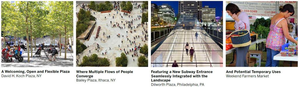
15 Figure 9-The Metro Commons-Conceptual Design and Precedent Images 15
16 The Promenade The Promenade connects the Metro Commons to the interior Lawn. The proposed design of the promenade envisions a unified public space that works both for pedestrians passing through and as a destination in itself. The Promenade will be appropriately sized to provide ample room for pedestrian circulation, while also providing a sense of enclosure to create a comfortable outdoor space. The Promenade is proposed to be lined by active ground floor uses. The Hyatt Hotel is currently in the process of adding an additional 1,000 square feet to the ground floor retail/restaurant uses to complement its existing retail uses, which will line the south side of the Promenade and includes outdoor dining and a new coffee shop. Both development options for the Project include active, ground floor uses that will line the north side of the Promenade and complement the restaurants and retail on the south side. Additionally, outdoor seating is contemplated as part of any restaurant uses on the ground floor space. The Promenade design will incorporate lighting, paving, seating, and landscaping that will be designed as part of an integrated experience. These design elements will create a dynamic experience that will draw visitors into the site, and encourage patrons to either sit and relax, or shop and dine. Figure 10-The Promenade-Conceptual Design and Precedent Images 16


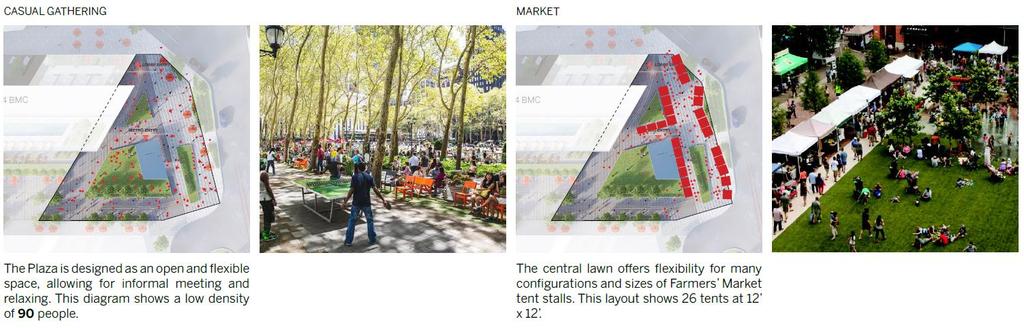
17 Figure 11-The Promenade- Precedent Images The Lawn This area is envisioned as a flexible, inviting green space. The proposed location will allow for the creation of an area for all of Bethesda, buffered from the noise and traffic of the surrounding streets by the proposed building. The Applicant's intention is to transform the lawn into a destination. This flexible space will be programmed with a variety of activities and events. Moveable seating is proposed to encourage visitors to interact within the space, creating a more flexible and dynamic space. It is also currently anticipated that retail kiosks can be incorporated around the periphery of the Lawn to further activate this public space. A portion of this open space area serves as the front door to both the existing Newlands Building and 3 Bethesda Metro Center. This Project will improve the functionality of that open space by removing steps, barriers and different levels so that it can be programmed for any number of events, and usable green space will be added to make it more inviting. The Lawn is designed to be completely programmable for activities that require less noise and more security from automobile traffic such as family movies on the lawn, concerts, social gatherings and other events. 17

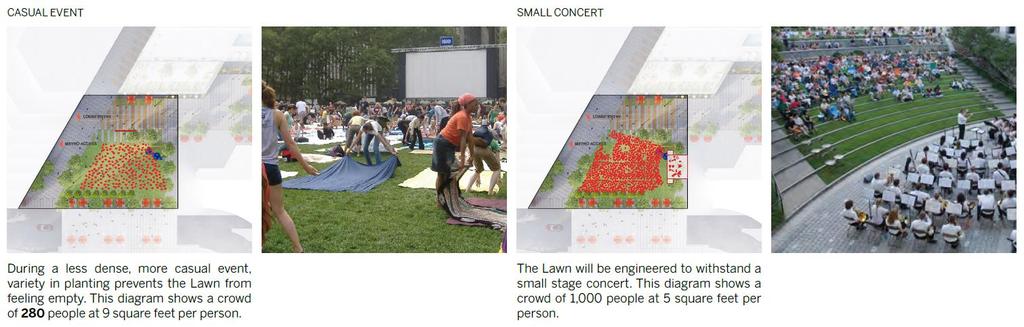
18 Figure 12-The Lawn-Conceptual Design and Precedent Images 18
19 The Metro Commons open area creates an inviting entry to the wide Promenade and the Lawn area which, together, when included with the central open area provided by the Newlands Building, offer the public nearly an acre of connected public use space. The Applicant has engaged its affiliate, "Arts Brookfield", to bring unique expertise to the programming of the Bethesda Metro open space, including both the Metro Commons along Wisconsin Avenue and the Lawn. The Applicant has engaged Streetsense, a local expert on retail to help design the retail promenade and other portions of the plaza. The new ground floor retail will interact with the Daily Grill restaurant/patio on the plaza and the new Starbucks in the Hyatt Hotel. While this new retail frontage on the southern side of the plaza demonstrates the possibility of a vibrant retail community, it is both the open space programming and retail activity that together will add new life into the open space at Metro Center. Environment Green Area Coverage The Bethesda Downtown Plan includes recommendations to achieve the urban green goals within the Sector Plan boundary. An important recommendation to this effect is the onsite 35% green area coverage minimum. The green cover may include singularly or a combination of intensive green roof (6 inches or deeper) or tree canopy cover. Furthermore, the Sector Plan s specify soil volume minimums (of 600 cubic feet per tree) associated with the tree plantings to help insure the desired canopy will be achieved. However, since only a portion of the Subject Property is proposed for redevelopment (rather than the entire 149,676 sf or 3.4-acre site) it is anticipated that the Applicant will not achieve the overall 35% minimum coverage for the Property. The Property was developed long before the current standards were in place and has relatively little canopy/green coverage. The currently submitted Green Cover plan demonstrates a 17.25% overall green cover and a 38.19% cover for the limit of work area. To help compensate for the Subject Property remaining short of the Sector Plans green cover minimum, and to provide a reasonable and measurable and goal, Staff recommends a condition of approval for the Applicant to provide an additional 10% of the work site area in green cover (or 48.19%). Staff notes that the version submitted for the Planning Board review does not reflect the revised layout which was recently presented to the Design Advisory Panel (DAP) on June 24, The more recent plans include additional greenspace with expanded opportunities for credit toward the green cover requirements. Furthermore, the green roof area currently shown on the proposed building is minimal and could readily be expanded to further the goals of the Sector Plan regarding green cover. Noise The project proposes residential units to be built adjacent to arterial roadways and would therefore be subject to a noise analysis needed at time of Preliminary Plan submission. However, a waiver may be submitted per Section of the 1983 Noise Guidelines. Forest Conservation Since the approval of the recent amendments to the Forest Conservation Law, all properties subject to a sketch plan filed on or after November 14, 2017 must have obtained approval of a Natural Resources Inventory/Forest Stand Delineation (NRI/FSD) or forest conservation exemption prior to the Planning Board acting on the sketch plan. The NRI/FSD is a document which maps the existing man-made and natural features associated with a project boundary and includes a study area which is typically 100 feet beyond the subject property. The NRI/FSD was approved for this project on June 27, A Forest Conservation Plan will be submitted as part of the future Preliminary/Site Plan submissions. Additionally, a Tree Save Plan may be required based on the final locations of the LOD, utility connections etc. relative to affected trees. 19
20 Stormwater Management (SWM) A Stormwater Management Concept Plan is not required at the time of Sketch Plan. Submission of the concept to the Department of Permitting Services (DPS) and approval will be required at the time of Preliminary Plan. The Stormwater Management Concept Plan should also address the Sector Plan recommendations regarding stormwater management, including green roofs, underground storage, bioretention and tree planting (Sector Plan, p. 59). Transportation Access and Circulation Pedestrian access to the site will be from the established sidewalk network and will be enhanced by streetscape improvements along each of the Site frontages, consistent with the Bethesda Streetscape Standards. No changes to the existing vehicular access points are proposed with the subject application. Existing vehicular access operates in the following manner (Figure 13): Edgemoor Lane operates as a two-way median-divided roadway along the site frontage. Public buses enter the Bethesda Metrorail station via Edgemoor Lane at the northwest corner of the site with a loading/ service access point located midway between the bus entrance and Woodmont Avenue. Woodmont Avenue operates as a one-way (southbound) roadway along the site frontage. A single point of garage ingress/ egress exists at the southwest corner of the site, adjacent to the intersection of Woodmont Avenue and North lane. Woodmont Avenue and North Lane each have an ingress/ egress lane at this intersection. North Lane and East Lane operate as one-way (eastbound/ southbound) service streets along the site s southern frontage. In addition to the garage access at the Woodmont Avenue/ North Lane intersection described above, North Lane and East Lane provide access to the Metrorail station kiss & ride and short term parking, and loading. Wisconsin Avenue operates as a six-lane median divided roadway along the site frontage. Site access along this roadway is limited to a single point of garage access (right-in/right-out) and a forecourt for the hotel. Old Georgetown Road operates as a one-way (northbound) roadway along the site frontage. No vehicuar access is permitted along this roadway. 20
, Metrobus, RideOn, the Bethesda Circulator and future Purple Line.")
21 Figure 13-Pedestrian and Vehicular Circulation Transit Connectivity The immediate area is well served by transit that includes the Red Line Bethesda Metrorail Station (located directly beneath the site), Metrobus, RideOn, the Bethesda Circulator and future Purple Line. Master Plan Roadways and Pedestrian/Bikeway Facilities The 2017 Bethesda Downtown Sector Plan recommends the following along property frontages: 1. Edgemoor Lane along the northern site frontage, as a Business District Street with a minimum right-ofway width of 80 feet and two-way separated bicycle lanes (LB-8) along the eastbound (property frontage) side of the street. 2. Woodmont Avenue along the western site frontage, as an arterial roadway with a minimum right-of-way width of 80 feet and separated bicycle lanes (CT-4) along the southbound (opposite frontage) side of the street. 3. North Lane along the southern site frontage, as a Business District Street with a minimum right-of-way width of 50 feet. 4. East Lane along the southern site frontage, as a Business District Street with a minimum right-of-way width of 50 feet. 5. Wisconsin Avenue along the eastern site frontage, as a major highway (M-6) with a minimum right-of-way width of 80 feet. 21
22 6. Old Georgetown Road along the northeastern site frontage, as a major highway (M-4) with a minimum right-of-way width of 80 feet and separated bicycle lanes (CT-8). Although a specific deisgn for the Old Georgetown Road separated bike lanes has not yet been determined, the current concept envisions this bicycle facility on the north side of Old Georgetown Road. Staff believes the north side of the roadway will better coordinate with plans for the East-West Highway (MD 410) separated bikeway which are also envisioned on the north side. Sector-Planned Transportation Demand Management The Sector Plan encourages a Non-Auto Driver Mode Share (NADMS) of 55%, averaged between employees and residents of downtown Bethesda. In order to meet this goal, downtown Bethesda is organized into a Transportation Demand Management District (TMD) that strives to promote travel by means other than singleoccupancy vehicles. Under either the Residential Development option or the Commercial Development option, the the development is required to enter into a Traffic Mitigation Agreement (TMAg) with the Planning Board and Montgomery County Department of Transportation (MCDOT) to participate in the Bethesda TMD. Specific details of the TMAg will be determined during the Preliminary Plan review. Adequate Public Facilities (APF) Of the two development options, the Commerical Development option is estimated to generate up to 423 morning peak-hour trips and 387 evening peak-hour trips. If the Applicant pursues the Residential Development option, the project will have a lower trip generation impact. Since the Project will generate more than 50 net new person trips, the Applicant must submit a transportation impact study in accordance with the Local Area Transportation Review requirement at the time of Preliminary Plan. If the Residential Development option is pursued, the APF review will need to evaluate impacts to school capacity. Community Outreach The Applicant held a pre-submittal public meeting at the Bethesda-Chevy Chase Regional Services Center on October 11, Seventeen people attended the meeting and raised questions/concerns including, but not limited to the public open space and activation of the space and improving the bus bay/metro (Attachment A). The Applicant has complied with all submittal and noticing requirements. The Applicant presented the Sketch Plan to the Bethesda Implementation Advisory Committee (IAC) on February 2, At the meeting there was discussion regarding the public open space, improvements to the bus bay/metro, activating the ground floor, public art (Attachment B). Staff has received much correspondence from the community about the relationship between the sizes and relative locations of the building and public open space on the site, particularly with regard to Wisconsin Avenue (Attachment C). While the majority cast this concern in terms of opposition, and a smaller but substantial portion as support, this is a significant urban design question that has been raised by staff and the DAP, and that the Applicant must answer as the design continues to develop. The 2017 Sector Plan is clear in its anticipation of a new building on this site; however, the function and operation of open space was also a high priority. The Applicant presented the updated design to the DAP and received comments and recommendations on the building form as is relates to the three open spaces intended to link Wisconsin Avenue to the bus bays, metro entrance and Edgemoor Lane. As the Applicant develops the design further, they will continue to coordinate with the community, staff, and the DAP to achieve an attractive, welcoming, and viable solution. 22
23 SECTION 4: PROJECT ANALYSIS AND FINDINGS The purpose of a Sketch Plan is to identify general land uses, development intensity, and public benefits for the optional method of development in the CR, CRT, EOF or LSC Zones. The Sketch Plan is intended to be conceptual in nature with an emphasis on building densities, massing, heights and anticipated uses, the locations of open and public use spaces, the general circulation patterns for all modes of transportation, an estimated range of peak hour trips and relationships between existing or proposed adjacent buildings and rights-of-way. Details of the proposed development are determined during Preliminary and Site Plan review. Section E of the Zoning Ordinance states: To approve a Sketch Plan the Planning Board must find that the following elements are appropriate in concept and appropriate for further detailed review at site plan. The Sketch Plan must: 1. meet the objectives, general requirements, and standards of this Chapter; The Sketch Plan meets the development standards of Section , as shown in the following Data Table: Sketch Plan Data Table Section Development Standard Permitted/ Required Proposed 59.4 Gross Tract Area per Zone CR 8.0 C 8.0 R 7.5 H ,830 sf (1.35 ac) n/a CR 8.0 C 8.0 R 7.5 H ,453 sf (2.99 ac) Total Gross Tract Area n/a 189,283 sf (4.34 ac) Prior Dedication Additional Dedication n/a n/a 37,569 sf (0.86 ac) 2,038 sf (0.05 ac) Net Lot Area n/a 149,676 sf (3.44 ac) Commercial Development option Non-Residential 1,514,264 sf (8.0 FAR) 858,578 sf (4.53 FAR) Other (Hotel to remain) Total Density 1,514,264 sf (8.0 FAR) 233,644 sf (1.23 FAR) 1,092,242 sf (5.77 FAR) Residential Development option Non-Residential Residential Other (Hotel to remain) Total Density 1,514,264 sf (8.0 FAR) 1,419,622 sf (7.5 FAR) 1,514,264 sf (8.0 FAR) 393,578 sf (2.07 FAR) 465,000 sf (2.45 FAR) 233,664 sf (1.23 FAR) 1,092,242 sf (5.77 FAR) Building Height CR 8.0 C 8.0 R 7.5 H 210 CR 8.0 C 8.0 R 7.5 H feet 290 feet NO CHANGE 290 feet Public Open Space (min) 10%/14,968 sq. ft. 28%/42,000 sq. ft. 1 1 Final square footage to be determined at the time of Site Plan. The Application will provide the minimum required number of bicycle parking spaces within the building, which will be determined at the time of Site Plan. The final number of vehicular parking spaces will be determined at Site Plan based on the final development option. At the time of Preliminary Plan submission, the Applicant will have selected the development option, either the Residential Development option which includes ground floor retail, restaurant and other activating uses with multi-unit residential uses above, and a minimum of 15% MPDUs or the Commercial Development option, which proposes non-residential, instead of residential development, above the ground floor uses. If the Applicant pursues the Commercial Development option, as conditioned, the Applicant must file a sketch 23
24 plan amendment at the time of Preliminary Plan, to address building design and relationship of the base with the open space areas, pedestrian circulation through the site, and design and function of the open space areas. The Sketch Plan conforms to the intent of the CR zone as described below. a) Implement the recommendations of applicable master plans. The Project substantially conforms to the recommendations for the Property included in the 2017 Bethesda Downtown Sector Plan. Specifically, this Plan builds on the past successes of Downtown Bethesda to create a truly sustainable downtown by focusing on components that will bolster the elements most in need of enhancement. The recommendations increase: 1. Parks and open spaces, including new civic greens at Veteran s Park, Bethesda Farm Women s Cooperative Market, Capital Crescent Trail and new urban parks, pathways and gateways. 2. Affordable housing, including the preservation of existing market-rate affordable housing, providing a mix of housing options and the provision of Moderately Priced Dwelling Units in exchange for development incentives. 3. Environmental innovation, including more energy-efficient buildings, better stormwater management, improved sidewalks and bicycle routes, and other measures to enhance community health and quality of life. 4. Economic competitiveness, based on new development, public amenities and proximity to public transit to attract businesses and visitors from throughout the region, and foster entrepreneurship and innovation. The Application is addressing and incorporating three of the four overarching goals. The project is providing a comprehensive redesign of the Metro Plaza. The approximately 42,000 square feet of public open space provided will consist of zones, intended to serve different functions, in order to meet the needs of various users of the site; environmental innovation through energy efficiency, innovative stormwater management solutions, improved pedestrian and bicycle opportunities around the site and through the site, in addition to improvements to the Metro bus facilities below and enhanced access to transit; and through economic competitiveness by incorporating new commercial development in downtown Bethesda in both development options. The proposed building located above the Metro Station, with access to public amenities and proposing a complete redesign of the Metro Plaza, will attract business opportunities in and around the Bethesda area. If the Residential Development option is selected, this Application will meet all four of the overarching goals by providing a mix of housing options, including 15% MPDUs. The Property is designated as site 98 and 99 on page 99 and 101 of the Plan. The Property is in the Wisconsin Avenue Corridor District, which is the main artery through the center of downtown Bethesda. With the existing Bethesda Metrorail Station, future Purple Line and bus rapid transit (BRT) options, Wisconsin Avenue is a critical focus area for improved access, mobility and pedestrian safety. The corridor is envisioned as a symbolic downtown center that reflects the character of adjacent neighborhoods and overall identity of Bethesda through innovative building designs and active public spaces. The area s retail potential is compromised by its location on either side of Wisconsin Avenue. As a major commuter arterial, this street has heavy traffic volumes that eliminate the potential for cross shopping and a lack of visibility for retail establishments. Specifically, the Project addresses the following goals as outlined in the Wisconsin Avenue Corridor section of the Plan: 24
25 Encourage infill and reinvestment on underutilized commercial sites and private surface parking lots. The Project provides an important opportunity for infill development of an underdeveloped commercial site, as recommended by the Sector Plan, with a mixed-use, transit-oriented Project. The Project will provide a variety of uses (including restaurant, retail/service, and residential or office) directly on top of the Bethesda Metro Station and bus facility, and within walking distance from the proposed Bethesda Purple Line Station, and other transit options (including the Bethesda Circulator). Provide new civic gathering spaces. The Project will provide a comprehensive redesign of the Metro Plaza with new public open space areas intended to serve different functions to meet the needs of various users of the site. Public open spaces include plazas, a central lawn area for performances, retail promenade, gallery and active areas. The Project will also provide several improvements to enhance access to and from the Metro/bus facilities, from the Metro Plaza and surrounding community including a new covered escalator that will provide a direct pedestrian connection between the Metro Plaza and transit facilities below, improvements to the existing staircase near the intersection of Woodmont Avenue and North Lane, and a new elevator at this location. These improvements are intended to enhance the community's experience when accessing the Metro Station and bus facilities and are designed to encourage use of the Metro Plaza above. Encourage mixed-income/affordable housing near transit stations. The Sector Plan recommended rezoning this Site to increase the commercial density and height to provide flexible development opportunities and allow future development to better adapt to market conditions. The Applicant is requesting flexibility in order to respond to changes in market demands and is requesting approval of two alternative development options. Both scenarios will adhere to the maximum development caps proposed for the Property. Although the Commercial Development option, if selected, would not provide mixed-income/affordable housing, both development options will provide substantial public benefits and amenities, including various improvements to the public open space at the Metro Plaza level, improvements to the Metro bus facilities below, and enhanced access to transit. The final allocation of uses will be determined at the time of Preliminary and Site Plan review. If the Project is developed with residential and retail uses, the Project will provide residential units on top of the metro station in an area dominated by commercial an office uses. The Project would provide much needed affordable housing in the form of additional MPDUs. This proposed influx of MPDUs will help to further one of the primary goals of the Sector Plan and Bethesda Overlay Zone thereby ensuring that affordable housing opportunities exist in transit-oriented locations. Develop compact nodes that place the highest intensity in those centers, provide distinctive infill buildings and step down to lower densities and heights near the edges. The Project will provide infill redevelopment within the highest intensity center in downtown Bethesda between adjacent commercial/office and hotel development. If the project is developed as residential it will provide a more around-the-clock activity contributing to a more vibrant mixeduse identity for the block. The combination of multi-family dwelling units, ground floor retail uses, 25
26 and amenities proposed for the block will create a more pedestrian friendly, active and functional metro plaza space. Encourage high-performance buildings and sites nearest the established centers. The Project proposes to incorporate energy efficient building systems to exceed the ASHRAE 90.1 standard by a minimum of 17.5%, as required by the Bethesda Overlay Zone. In addition, intensive green roof systems, planters and green area at the plaza level are proposed to maximize the Property s overall green cover. Improve and enhance underutilized privately owned public use spaces. The Project will greatly improve and enhance downtown Bethesda s central civic space and premier public transit facility in the Metro station by comprehensively redesigning the Metro Plaza and upgrading various transit functions below with improved circulation and functionality, added public amenities and by providing additional commercial, retail and/or residential uses that will activate and enliven the area around-the-clock and ensure a more successful public realm. Both of the Project s proposed development options are in general conformance with the 2017 Bethesda Downtown Sector Plan and will provide a mix of uses at an appropriate density. b) Target opportunities for redevelopment of single-use commercial areas and surface parking lots with a mix of uses. The Project provides an important opportunity for infill development of an underdeveloped commercial site, as recommended by the Sector Plan, with a mixed-use, transit-oriented Project. The Project proposes a variety of uses (including restaurant, retail/service, and residential or office) within walking distance of the Bethesda Metro Station, various bus routes, the proposed Bethesda Purple Line Station, and other transit options. c) Encourage development that integrates a combination of housing types, mobility options, commercial services, and public facilities and amenities, where parking is prohibited between the building and the street. Both development options provide significant public benefits and amenities, including various improvements to Metro bus facilities and Metro Plaza, as well as transit access improvements. Additionally, the location of the Project, atop the Metro Station and bus area, will facilitate the use of multiple modes of transportation to access to the Property. The Residential Development option proposing market-rate residential units in a variety of unit types as well as 15% MPDUs, offering housing opportunities for a range of incomes proximate to the numerous transit options of downtown Bethesda. Although housing would not be provided in the Commercial Development option, the Subject Property has nearby existing and proposed high-rise multi-family buildings. Existing mobility options include improved streetscapes for pedestrians in and around the Subject Property and along the Wisconsin Avenue corridor, as well as planned bike lanes on three frontages of the Property. Below-grade parking is proposed for both development options, taking advantage of the existing, bellow-grade parking garage. Public amenities including bike share, public open space, streetscape improvements are integral to the design and operation of the site. The Project facilitates all modes of transit pedestrian, bicycle, and vehicular in close proximity to the Metro and bus service by 26
MONTGOMERY COUNTY PLANNING DEPARTMENT THE MARYLAND NATIONAL CAPITAL PARK AND PLANNING COMMISSION
 MONTGOMERY COUNTY PLANNING DEPARTMENT THE MARYLAND NATIONAL CAPITAL PARK AND PLANNING COMMISSION MCPB Item No. Date: 5.3.18 8000 Wisconsin Avenue Sketch Plan No. 320180120 Matthew Folden, Planner Coordinator,
4 Bethesda Metro Center, Bethesda, Maryland Statement of Justification Sketch Plan
 I. Introduction 4 Bethesda Metro Center, Bethesda, Maryland Statement of Justification Sketch Plan BOP Bethesda Metro Center LLC, an affiliate of Brookfield Property Partners (the "Applicant") is submitting
MONTGOMERY COUNTY PLANNING DEPARTMENT
 MONTGOMERY COUNTY PLANNING DEPARTMENT THE MARYLAND-NATIONAL CAPITAL PARK AND PLANNING COMMISSION MCPB Item No. Date: 04/05/2018 850 Sligo Avenue Sketch Plan No. 320180090 Neil Sullivan, Planner Coordinator,
MONTGOMERY COUNTY PLANNING DEPARTMENT THE MARYLAND-NATIONAL CAPITAL PARK AND PLANNING COMMISSION
 MONTGOMERY COUNTY PLANNING DEPARTMENT THE MARYLAND-NATIONAL CAPITAL PARK AND PLANNING COMMISSION MCPB Item No. Date: 3.10.2016 Site Plan 820160040 Nora School Parker Smith, Planning Technician, Area 1,
MONTGOMERY COUNTY PLANNING DEPARTMENT THE MARYLAND-NATIONAL CAPITAL PARK AND PLANNING COMMISSION
 MONTGOMERY COUNTY PLANNING DEPARTMENT THE MARYLAND-NATIONAL CAPITAL PARK AND PLANNING COMMISSION MCPB Item No. Date: 10.25.18 Artery Plaza: Site Plan Amendment 81984002E SD Stephanie Dickel, Planner Coordinator,
MONTGOMERY COUNTY PLANNING DEPARTMENT THE MARYLAND-NATIONAL CAPITAL PARK AND PLANNING COMMISSION
 MONTGOMERY COUNTY PLANNING DEPARTMENT THE MARYLAND-NATIONAL CAPITAL PARK AND PLANNING COMMISSION MCPB Item No. Date: 1/26/12 Hanover Shady Grove, Sketch Plan 320120020 Joshua Sloan, Coordinator, Joshua.Sloan@MontgomeryPlanning.org,
MONTGOMERY COUNTY PLANNING DEPARTMENT THE MARYLAND NATIONAL CAPITAL PARK AND PLANNING COMMISSION
 MONTGOMERY COUNTY PLANNING DEPARTMENT THE MARYLAND NATIONAL CAPITAL PARK AND PLANNING COMMISSION MCPB Item No. 5 Date: 07/19/18 7607 Old Georgetown Road, Sketch Plan No. 320180160 Description Grace Bogdan,
MONTGOMERY COUNTY PLANNING DEPARTMENT THE MARYLAND-NATIONAL CAPITAL PARK AND PLANNING COMMISSION
 MONTGOMERY COUNTY PLANNING DEPARTMENT THE MARYLAND-NATIONAL CAPITAL PARK AND PLANNING COMMISSION MCPB Item No. Date10/25/12 Sketch Plan No. 32012004, White Flint Mall Redevelopment Nkosi Yearwood, Senior
MONTGOMERY COUNTY PLANNING DEPARTMENT THE MARYLAND-NATIONAL CAPITAL PARK AND PLANNING COMMISSION
 MONTGOMERY COUNTY PLANNING DEPARTMENT THE MARYLAND-NATIONAL CAPITAL PARK AND PLANNING COMMISSION MCPB Item No. Date: 7/30/2015 Pooks Hill Sketch Plan No. 320150060 Kathleen A. Reilly, AICP Planner Coordinator,
PROJECT NARRATIVE AND JUSTIFICATION STATEMENT
 7000 WISCONSIN AVENUE SKETCH PLAN NO. 320190090 PROJECT NARRATIVE AND JUSTIFICATION STATEMENT I. INTRODUCTION Starr Capital LLC and Woodfield Development Company (collectively, the Applicant ) are the
MONTGOMERY COUNTY PLANNING DEPARTMENT THE MARYLAND-NATIONAL CAPITAL PARK AND PLANNING COMMISSION
 MONTGOMERY COUNTY PLANNING DEPARTMENT THE MARYLAND-NATIONAL CAPITAL PARK AND PLANNING COMMISSION MCPB Item No. 2 Date: 2.8.2018 7359 Wisconsin Avenue: Sketch Plan No. 320180070, Preliminary Plan No. 120180040,
MONTGOMERY COUNTY PLANNING DEPARTMENT THE MARYLAND-NATIONAL CAPITAL PARK AND PLANNING COMMISSION
 MONTGOMERY COUNTY PLANNING DEPARTMENT THE MARYLAND-NATIONAL CAPITAL PARK AND PLANNING COMMISSION MCPB Item No. Date: 12/11/2014 Ripley East Sketch Plan No. 320150010 SD Stephanie Dickel, Planner Coordinator,
MONTGOMERY COUNTY PLANNING DEPARTMENT THE MARYLAND-NATIONAL CAPITAL PARK AND PLANNING COMMISSION
 MONTGOMERY COUNTY PLANNING DEPARTMENT THE MARYLAND-NATIONAL CAPITAL PARK AND PLANNING COMMISSION Staff Report: Sketch Plan #320110010, Mid-Pike Plaza ITEM #: MCPB HEARING DATE: January 20, 2011 REPORT
MONTGOMERY COUNTY PLANNING DEPARTMENT THE MARYLAND-NATIONAL CAPITAL PARK AND PLANNING COMMISSION
 MONTGOMERY COUNTY PLANNING DEPARTMENT THE MARYLAND-NATIONAL CAPITAL PARK AND PLANNING COMMISSION MCPB Item No. 8 Date: 12-15-16 Montgomery Village Center Sketch Plan No. 320170020 TL Troy Leftwich, Senior
MONTGOMERY COUNTY PLANNING DEPARTMENT THE MARYLAND NATIONAL CAPITAL PARK AND PLANNING COMMISSION
 MONTGOMERY COUNTY PLANNING DEPARTMENT THE MARYLAND NATIONAL CAPITAL PARK AND PLANNING COMMISSION MCPB Item No. 8 Date: 3.30.2017 Project Name: Lot 31/31A Bethesda, Site Plan Amendment, No. 82007018C Elza
MONTGOMERY COUNTY PLANNING DEPARTMENT
 MONTGOMERY COUNTY PLANNING DEPARTMENT THE MARYLAND-NATIONAL CAPITAL PARK AND PLANNING COMMISSION MCPB Item No.: Date: 5-03-18 Pike and Rose, Phase I: Site Plan Amendment No. 82012002D Rhoda Hersson-Ringskog,
MONTGOMERY COUNTY PLANNING DEPARTMENT THE MARYLAND-NATIONAL CAPITAL PARK AND PLANNING COMMISSION
 MONTGOMERY COUNTY PLANNING DEPARTMENT THE MARYLAND-NATIONAL CAPITAL PARK AND PLANNING COMMISSION MCPB Item No. Date: 05/12/2016 North Bethesda Conference Center Parking Structure, Mandatory Referral No.
MONTGOMERY COUNTY PLANNING DEPARTMENT
 MONTGOMERY COUNTY PLANNING DEPARTMENT THE MARYLAND-NATIONAL CAPITAL PARK AND PLANNING COMMISSION Ourisman Ford at Montgomery Mall, Sketch Plan No. 320170100 MCPB Item No. Date: 11-30-17 LS Lori Shirley,
Policies and Code Intent Sections Related to Town Center
 Policies and Code Intent Sections Related to Town Center The Town Center Vision is scattered throughout the Comprehensive Plan, development code and the 1994 Town Center Plan. What follows are sections
I. Introduction. Prior Approvals
 Statement of Justification First National Bank 19790 Crystal Rock Drive, Germantown, Maryland Application for Site Plan and Limited Preliminary Plan Amendment I. Introduction DPH Architecture, for First
The subject site plan amendment proposes the following revisions to the approved site plan:
 PROPOSED AMENDMENT The subject site plan amendment proposes the following revisions to the approved site plan: 1. The building footprint was modified to accommodate the revised architectural design. 2.
DRAFT. October Wheaton. Design Guidelines
 October 2011 DRAFT Wheaton Design Guidelines 2 Draft - Design Guidelines - Wheaton Sector Plan Contents 04 Section 1: Introduction 06 Section 2: Context 08 Section 3: Design Guidelines 09 Goal 1: Create
MONTGOMERY COUNTY PLANNING DEPARTMENT THE MARYLAND NATIONAL CAPITAL PARK AND PLANNING COMMISSION
 MONTGOMERY COUNTY PLANNING DEPARTMENT THE MARYLAND NATIONAL CAPITAL PARK AND PLANNING COMMISSION MCPB Item No. 3 Date: 1.5.17 7272 Wisconsin Avenue: Sketch Plan Amendment No. 32016004A, Preliminary Plan
Ripley East. Sketch Plan Amendment No A Preliminary Plan No Site Plan No MONTGOMERY COUNTY PLANNING DEPARTMENT
 Ripley East Sketch Plan Amendment No. 32015001A Preliminary Plan No. 120150220 Site Plan No. 820150130 Planning Board Hearing Date: December 3, 2015 Site Vicinity and Site Description Silver Spring Transit
Gold Line Bus Rapid Transit Transit Oriented Development (BRTOD) Helmo Station Area Plan
 Helmo Station Area Plan") Appendix F Gold Line Bus Rapid Transit Transit Oriented Development (BRTOD) Helmo Station Area Plan Introduction and Purpose of the Plan The Gold Line Bus Rapid Transit facility is an eleven-mile dedicated
Appendix F Gold Line Bus Rapid Transit Transit Oriented Development (BRTOD) Helmo Station Area Plan Introduction and Purpose of the Plan The Gold Line Bus Rapid Transit facility is an eleven-mile dedicated
MONTGOMERY COUNTY PLANNING DEPARTMENT THE MARYLAND-NATIONAL CAPITAL PARK AND PLANNING COMMISSION
 MONTGOMERY COUNTY PLANNING DEPARTMENT THE MARYLAND-NATIONAL CAPITAL PARK AND PLANNING COMMISSION MCPB Item No. Date: 11-16-17 Hillandale Gateway, Sketch Plan, 320180020 Summary Lori Shirley, Planner Coordinator,
MONTGOMERY COUNTY PLANNING DEPARTMENT THE MARYLAND-NATIONAL CAPITAL PARK AND PLANNING COMMISSION
 MONTGOMERY COUNTY PLANNING DEPARTMENT THE MARYLAND-NATIONAL CAPITAL PARK AND PLANNING COMMISSION MCPB Item No. Date: 04/24/2014 Sketch Plan No. 320140020, AVA Wheaton Michael Brown, Planner Coordinator,
ELMVALE ACRES SHOPPING CENTRE MASTER PLAN
 ELMVALE ACRES SHOPPING CENTRE MASTER PLAN Contents 1.0 INTRODUCTION... 2 2.0 LOCATION... 2 3.0 EXISTING CONTEXT... 2 4.0 VISION & GUIDING PRINCIPLES... 2 5.0 LAND USE AND BUILT FORM... 4 5.1 St. Laurent
Bethesda Downtown Design Advisory Panel Submission Form
 Bethesda Downtown Design Advisory Panel Submission Form PROJECT INFORMATION Project Name File Number(s) Project Address Plan Type Concept Plan Sketch Plan Site Plan APPLICANT TEAM Primary Contact Architect
Sketch Plan. MNCPPC Plan No: A
 General Notes 1. The Sketch Plan drawings are conceptual only and represent proposed development in an illustrative manner. Final building locations, dimensions, heights, uses and development standards
MONTGOMERY COUNTY PLANNING DEPARTMENT THE MARYLAND-NATIONAL CAPITAL PARK AND PLANNING COMMISSION
 MONTGOMERY COUNTY PLANNING DEPARTMENT THE MARYLAND-NATIONAL CAPITAL PARK AND PLANNING COMMISSION MCPB Item No.: 2 Date: 12-19-13 Site Plan 820140020, 8001 Newell Street Neil Braunstein, AICP, Area 1, neil.braunstein@montgomeryplanning.org,
MONTGOMERY COUNTY PLANNING DEPARTMENT THE MARYLAND-NATIONAL CAPITAL PARK AND PLANNING COMMISSION
 MONTGOMERY COUNTY PLANNING DEPARTMENT THE MARYLAND-NATIONAL CAPITAL PARK AND PLANNING COMMISSION MCPB Item No. 6 Date: 7.22.13 Bethesda Purple Line Station Minor Master Plan Amendment, Scope of Work Elza
Hockessin Community Redevelopment Plan
 Hockessin Community Redevelopment Plan 3.1 Introduction The Community Redevelopment Plan for the Village of Hockessin is the result of the people s vision for a distinct village center that serves as the
EXISTING COMPREHENSIVE PLAN
 EXISTING COMPREHENSIVE PLAN Town Center Land Use Element: V. LAND USE POLICIES Town Center Mercer Island's business district vision as described in "Your Mercer Island Citizen-Designed Downtown" was an
MONTGOMERY COUNTY PLANNING DEPARTMENT THE MARYLAND-NATIONAL CAPITAL PARK AND PLANNING COMMISSION
 MONTGOMERY COUNTY PLANNING DEPARTMENT THE MARYLAND-NATIONAL CAPITAL PARK AND PLANNING COMMISSION MCPB Item No. Date: 05-22-14 Consent Item - Park Potomac: Site Plan Amendment No. 82004015K MCS. Molline
12 January 12, 2011 Public Hearing APPLICANT: TAILWIND DEVELOPMENT GROUP,LLC PROPERTY OWNER: CITY OF VIRGINIA BEACH
 12 January 12, 2011 Public Hearing APPLICANT: TAILWIND DEVELOPMENT GROUP,LLC PROPERTY OWNER: CITY OF VIRGINIA BEACH STAFF PLANNER: Faith Christie REQUEST: Conditional Change of Zoning (from PD-H1 Planned
MONTGOMERY COUNTY PLANNING DEPARTMENT THE MARYLAND NATIONAL CAPITAL PARK AND PLANNING COMMISSION
 MONTGOMERY COUNTY PLANNING DEPARTMENT THE MARYLAND NATIONAL CAPITAL PARK AND PLANNING COMMISSION MCPB Item No. 7 Date: 7.19.18 ZOM Bethesda, Preliminary Plan No. 120180140 and Site Plan No. 820180120 Matthew
PROJECT NARRATIVE AND JUSTIFICATION STATEMENT
 8000 WISCONSIN AVENUE SKETCH PLAN NO. 320180120 PROJECT NARRATIVE AND JUSTIFICATION STATEMENT I. INTRODUCTION Aksoylu Properties (the Applicant ) is the contract purchaser of 7938, 7940, 7942, and 8000
4.1.3 LAND USE CATEGORIES
 4.1.3 LAND USE CATEGORIES a. City Center District The City Center District incorporates the existing character and mix of uses in downtown Belmont to encourage redevelopment and new development in keeping
STATEMENT OF JUSTIFICATION CLARKSBURG PREMIUM OUTLETS AT CABIN BRANCH NORTH DISTRICT, PHASE
 STATEMENT OF JUSTIFICATION CLARKSBURG PREMIUM OUTLETS AT CABIN BRANCH NORTH DISTRICT, PHASE 1 Southwest Corner of Clarksburg Road and Interstate-270 Clarksburg, Maryland Application for Site Plan #820140160
MONTGOMERY COUNTY PLANNING DEPARTMENT
 MONTGOMERY COUNTY PLANNING DEPARTMENT THE MARYLAND-NATIONAL CAPITAL PARK AND PLANNING COMMISSION Ashburton Elementary School Addition, Mandatory Referral, MR2018009 MCPB Item No. Date: 02-15-18 Troy Leftwich,
THE 355/270 CORRIDOR:
 THE 355/270 CORRIDOR: Strategic Ideas for Sustaining a Livable Work Place Project Summary ACCESS LIFE DESIGN HEALTH WORK Montgomery County Planning Department The Maryland-National Capital Park and Planning
MONTGOMERY COUNTY PLANNING DEPARTMENT THE MARYLAND-NATIONAL CAPITAL PARK AND PLANNING COMMISSION
 MONTGOMERY COUNTY PLANNING DEPARTMENT THE MARYLAND-NATIONAL CAPITAL PARK AND PLANNING COMMISSION MCPB Item No. 4 7/18/13 4990 Fairmont Avenue, Project Plan 920130070 & Preliminary Plan 120130230 Erin Grayson,
Town Center (part of the Comprehensive Plan)
") Town Center (part of the Comprehensive Plan) Mercer Island Town Center Looking North (2014) In 1994, a year-long process culminated in a set of design guidelines and code requirements for the Town Center
Town Center (part of the Comprehensive Plan) Mercer Island Town Center Looking North (2014) In 1994, a year-long process culminated in a set of design guidelines and code requirements for the Town Center
Strathmore Square Sketch Plan Statement of Justification and Narrative Description
 Strathmore Square Sketch Plan Statement of Justification and Narrative Description I. Introduction Fivesquares Development, LLC (the "Applicant" or "Fivesquares") is submitting this application for Sketch
Statement of Justification for Sketch Plan Application No BETHESDA MARKET
 Statement of Justification for Sketch Plan Application No. 320190030 BETHESDA MARKET 7121 WISCONSIN AVENUE, 7126 WISCONSIN AVENUE, 7140 WISCONSIN AVENUE, 4705 MILLER AVENUE, FARM WOMEN'S COOPERATIVE MARKET
MONTGOMERY COUNTY PLANNING DEPARTMENT THE MARYLAND-NATIONAL CAPITAL PARK AND PLANNING COMMISSION
 MONTGOMERY COUNTY PLANNING DEPARTMENT THE MARYLAND-NATIONAL CAPITAL PARK AND PLANNING COMMISSION MCPB Item Date: 09/08/16 The Collection (Formerly Chevy Chase Center): Site Plan Amendment No. 82001013C,
The transportation system in a community is an
 7 TRANSPORTATION The transportation system in a community is an important factor contributing to the quality of life of the residents. Without a sound transportation system to bring both goods and patrons
MONTGOMERY COUNTY PLANNING DEPARTMENT
 MONTGOMERY COUNTY PLANNING DEPARTMENT THE MARYLAND-NATIONAL CAPITAL PARK AND PLANNING COMMISSION 6000 Executive Boulevard, Sketch Plan No. 320180140 MCPB Item No. Date: 06/21/2018 Emily Tettelbaum, Senior
MONTGOMERY COUNTY PLANNING DEPARTMENT THE MARYLAND-NATIONAL CAPITAL PARK AND PLANNING COMMISSION
 MONTGOMERY COUNTY PLANNING DEPARTMENT THE MARYLAND-NATIONAL CAPITAL PARK AND PLANNING COMMISSION MCPB Item No. Date: 06-12-14 King of the Nations Christian Fellowship Church: Limited Site Plan Amendment
Westwood Shopping Center Sketch Plan, Plan # February 23, 2017 Item # 9
 Westwood Shopping Center Sketch Plan, Plan # 320170010 February 23, 2017 Item # 9 Westwood II Site 64,111 s.f. Manor Care site: vacant two story building HOC-Westwood Towers, 15 story tower To be considered
MONTGOMERY COUNTY PLANNING DEPARTMENT THE MARYLAND-NATIONAL CAPITAL PARK AND PLANNING COMMISSION
 MONTGOMERY COUNTY PLANNING DEPARTMENT THE MARYLAND-NATIONAL CAPITAL PARK AND PLANNING COMMISSION MCPB Item No. 6 Date: 5-9-13 Site Plan No. 820130090, West Chevy Chase Heights Erin Grayson, Senior Planner,
Welcome. Walk Around. Talk to Us. Write Down Your Comments
 Welcome This is an information meeting introducing the applications for proposed redevelopment of the Yorkdale Shopping Centre site at 3401 Dufferin Street and 1 Yorkdale Road over the next 20+ years,
Planning Board Briefing
 Planning Board Briefing Why Now? The Sector Plan Implementation Chapter States: Before Stage 1 begins, the following must occur: Approval of the Sectional Map Amendment. Approval of the Greater Lyttonsville
S C O P E O F W O R K A P R I L
 white flint 2 sector plan S C O P E O F W O R K A P R I L 2 0 1 2 MONTGOMERY COUNTY PLANNING DEPARTMENT M-NCPPC MontgomeryPlanning.org 1 white flint 2 sector plan Scope of Work abstract This scope of work
Westwind Developments Ltd. PIONEER LANDS AREA STRUCTURE PLAN - PROPOSED AMENDMENT
 FEBRUARY 2013 TABLE OF CONTENTS 1.0 BACKGROUND... 1 1.1 Amendment... 1 2.0 LOCATION & CONTEXT... 2 2.1 Land Ownership... 2 3.0 POLICY CONTEXT... 3 3.1 Municipal Development Plan... 3 3.2 Capital Region
Public input has been an important part of the plan development process.
 Lakewood s Comprehensive Plan recognizes that transportation helps shape the community, and that the way the community provides for the safe and efficient movement of people affects the character of the
Transportation. Strategies for Action
 Transportation A major priority for the Overlake Neighborhood is to develop a multimodal transportation system. To achieve this system, a balance has to be found among travel, circulation and access needs;
MONTGOMERY COUNTY PLANNING DEPARTMENT THE MARYLAND-NATIONAL CAPITAL PARK AND PLANNING COMMISSION
 MONTGOMERY COUNTY PLANNING DEPARTMENT THE MARYLAND-NATIONAL CAPITAL PARK AND PLANNING COMMISSION 8015 Old Georgetown Road, Preliminary Plan 120160220, Site Plan 820160090 MCPB Item No.: 8 Date: 11-03-16
Executive Summary. NY 7 / NY 2 Corridor
 Executive Summary NY 7 / NY 2 Corridor Transportation and Land Use Study December 2005 Prepared for: Town of Colonie Capital District Transportation Committee Prepared by: Introduction: Land use decisions
MONTGOMERY COUNTY PLANNING DEPARTMENT THE MARYLAND-NATIONAL CAPITAL PARK AND PLANNING COMMISSION
 MONTGOMERY COUNTY PLANNING DEPARTMENT THE MARYLAND-NATIONAL CAPITAL PARK AND PLANNING COMMISSION MCPB Item No. Date: 12-10-15 Leisure World Clubhouse II Addition Fitness Center, Limited Site Plan Amendment
City of Farmington. Downtown Plan. Amendment to the 1998 Master Plan Adopted October 11, 2004
 City of Farmington Amendment to the 1998 Master Plan Adopted October 11, 2004 Introduction Planning Background 1 Scope and Components of the Plan Amendment 2 Concept Introduction 3 Plan Concepts 3 Conceptual
Courthouse Square Planning & Urban Design Study. Courthouse Square Working Group #13 October 15, 2014
 Courthouse Square Planning & Urban Design Study Courthouse Square Working Group #13 October 15, 2014 1 Courthouse Square Process Working Group Community Courthouse Square Advisory Groups & Civic Associations
ARLINGTON COUNTY, VIRGINIA
 ARLINGTON COUNTY, VIRGINIA County Board Agenda Item Meeting October 15, 2005 DATE: September 28, 2005 SUBJECT: Request to Advertise the adoption of the 2005 Clarendon Sector Plan C. M. RECOMMENDATION:
Wheaton CBD & Vicinity Sector Plan D E S I G N G U I D E L I N E S
 Wheaton CBD & Vicinity Sector Plan D E S I G N G U I D E L I N E S 1 a b s t r a c t This document contains the design guidelines the property owners, community members, and planners should use to implement
MONTGOMERY COUNTY PLANNING DEPARTMENT THE MARYLAND-NATIONAL CAPITAL PARK AND PLANNING COMMISSION
 MONTGOMERY COUNTY PLANNING DEPARTMENT THE MARYLAND-NATIONAL CAPITAL PARK AND PLANNING COMMISSION MCPB Item No. Date: 9/22/16 Ripley II: Sketch Plan Amendment No. 32015003A, Preliminary Plan No. 120160190,
Description. Summary. MCPB Item No. Date: 01/17/13. Bethesda Crescent, Limited Site Plan Amendment, A, A
 THE MARYLAND-NATIONAL CAPITAL PARK AND PLANNING COMMISSION MCPB Item No. Date: 01/17/13 Bethesda Crescent, Limited Site Plan Amendment, 81984005A, 81984003A Parag Agrawal, Senior Planner, parag.agrawal@montgomeryplanning.org,
Status Report: MD 355 Project
 Status Report: MD 355 Project OCTOBER 2006 M-NCPPC MONTGOMERY COUNTY PLANNING DEPARTMENT Summary of Community Comments, and break to the Results of the MD 355 Participation Session Brookside Gardens -
LAND USE AMENDMENT DOWNTOWN COMMERCIAL CORE (WARD 7) MACLEOD TRAIL SE AND 5 AVENUE SE BYLAW 254D2017
 MACLEOD TRAIL SE AND 5 AVENUE SE BYLAW 254D2017") Page 1 of 10 EXECUTIVE SUMMARY This Land Use Amendment application seeks to redesignate a full downtown block (currently the YWCA site) from a Direct Control based on the CM-2 District (Land Use Bylaw
Page 1 of 10 EXECUTIVE SUMMARY This Land Use Amendment application seeks to redesignate a full downtown block (currently the YWCA site) from a Direct Control based on the CM-2 District (Land Use Bylaw
MONTGOMERY COUNTY PLANNING DEPARTMENT
 MONTGOMERY COUNTY PLANNING DEPARTMENT THE MARYLAND-NATIONAL CAPITAL PARK AND PLANNING COMMISSION MCPB Item No. Date: 12/20/2018 Nucci Subdivision, Preliminary Plan No. 120160170 MF Marco Fuster, Planner
MONTGOMERY COUNTY PLANNING DEPARTMENT THE MARYLAND-NATIONAL CAPITAL PARK AND PLANNING COMMISSION
 MONTGOMERY COUNTY PLANNING DEPARTMENT THE MARYLAND-NATIONAL CAPITAL PARK AND PLANNING COMMISSION MCPB Item No. 6 Date: 03-14-13 Bethesda Commerce, Project Plan, 920130030 Tina Schneider, Senior Planner,
Urban Planning and Land Use
 Urban Planning and Land Use 701 North 7 th Street, Room 423 Phone: (913) 573-5750 Kansas City, Kansas 66101 Fax: (913) 573-5796 Email: planninginfo@wycokck.org www.wycokck.org/planning To: From: City Planning
Complete Neighbourhood Guidelines Review Tool
 Complete Neighbourhood Guidelines Review Tool Prepared By: City of Regina Planning Department October 2014 Page 1 of 14 Community Development Review Checklist for Secondary Plans and Concept Plans The
TO: FROM: SUBJECT: Background
 TO: FROM: SUBJECT: Long Range Planning Committee and Zoning Committee of the Planning Commission Kellie Brown and Margaret Rhodes, Planning Division, CPHD DATE: June 8, 2017 Courthouse Square Implementation
Millbrae TOD #2 Project Analysis
 Millbrae TOD #2 Project Analysis Project Description A Site Development Permit and Conditional Use Permit are proposed to allow for a mixed-use transitoriented development on approximately 9 Acres located
MONTGOMERY COUNTY PLANNING DEPARTMENT THE MARYLAND-NATIONAL CAPITAL PARK AND PLANNING COMMISSION
 MONTGOMERY COUNTY PLANNING DEPARTMENT THE MARYLAND-NATIONAL CAPITAL PARK AND PLANNING COMMISSION MCPB Item No. 3 4/3/14 4990 Fairmont Avenue, Site Plan 820140060 Erin Banks, AICP, Senior Planner, Area
MONTGOMERY COUNTY PLANNING DEPARTMENT THE MARYLAND-NATIONAL CAPITAL PARK AND PLANNING COMMISSION
 MONTGOMERY COUNTY PLANNING DEPARTMENT THE MARYLAND-NATIONAL CAPITAL PARK AND PLANNING COMMISSION MCPB Item No. Date: 1/15/2015 Bethesda North Marriott Hotel and Conference Center: Limited Site Plan Amendment
MONTGOMERY COUNTY PLANNING DEPARTMENT
 MONTGOMERY COUNTY PLANNING DEPARTMENT THE MARYLAND-NATIONAL CAPITAL PARK AND PLANNING COMMISSION MCPB Item No. Date: 11-8-18 Strathmore Square, Sketch Plan 320190010 Emily Tettelbaum, Planner Coordinator,
The Development Review Process. Presentation to the GSSC IAC
 The Development Review Process Presentation to the GSSC IAC July 19, 2011 Regulatory Processes in the Planning Department Natural Resource Inventory/Forest Stand Delineation Zoning (Development Plan) Special
Bethesda. Downtown Plan Design Guidelines. Approved July access + mobility. community identity. habitat + health. equity. water.
 Bethesda Downtown Plan Design Guidelines community identity equity habitat + health access + mobility water energy Approved July 2017 THE MONTGOMERY COUNTY PLANNING DEPARTMENT THE MARYLAND-NATIONAL CAPITAL
JUSTIFICATION STATEMENT FOR SKETCH PLAN NO Sketch Plan Justification for Ourisman Ford
 I. INTRODUCTION JUSTIFICATION STATEMENT FOR SKETCH PLAN NO. 320170100 Sketch Plan Justification for Ourisman Ford Owner and Applicant, FP Whitro Westlake, LLC ( Applicant ), by its attorneys, Linowes and
AWH REPORT OF THE PLANNING AND DEVELOPMENT DEPARTMENT FOR APPLICATION FOR REZONING ORDINANCE TO PLANNED UNIT DEVELOPMENT
 AWH REPORT OF THE PLANNING AND DEVELOPMENT DEPARTMENT FOR APPLICATION FOR REZONING ORDINANCE TO PLANNED UNIT DEVELOPMENT MAY 8, 2014 The Planning and Development Department hereby forwards to the Planning
MONTGOMERY COUNTY PLANNING DEPARTMENT THE MARYLAND-NATIONAL CAPITAL PARK AND PLANNING COMMISSION
 MONTGOMERY COUNTY PLANNING DEPARTMENT THE MARYLAND-NATIONAL CAPITAL PARK AND PLANNING COMMISSION MCPB Item No. Date: 7/26/12 Camden Shady Grove (Danac Stiles), Sketch Plan 320120050 Joshua Sloan, Planner
CRYSTAL CITY BLOCK PLAN # CCBP- G 1 DRAFT
 CRYSTAL CITY BLOCK PLAN # CCBP- G 1 DRAFT BLOCK G (Metro Market Square block) Long Range Planning Committee Meeting January 29, 2018 1 1. Introduction 2 1. LRPC Meeting Purpose Review of proposed Crystal
38 Queen s University Campus Master Plan Part 1
 38 Queen s University Campus Master Plan Part 1 46 The Campus at the City Scale Chapter 4 The Campus at the City Scale 39 Queen s is an urban University centrally located in Kingston. Decisions made by
COMMUNITY DESIGN. GOAL: Create livable and attractive communities. Intent
 COMMUNITY DESIGN Intent An attractive, well-designed County will attract quality development, instill civic pride, improve the visual character of the community, and create a strong, positive image for
Review of Opportunity Area C Draft Comprehensive Plan and Draft BOS Follow-On Motions. Special Working Group Meeting March 4, 2015
 Review of Opportunity Area C Draft Comprehensive Plan and Draft BOS Follow-On Motions Special Working Group Meeting March 4, 2015 The slides that follow identify where the draft Comprehensive Plan has
Civic Center District
 Civic Center District The Civic Center district is the civic and social heart of Warrenville, containing such public buildings as the City Hall, Warrenville Public Library, Police Station, Park District
FRUITVALE TRANSIT VILLAGE (Phase 2) Residential Project
 Residential Project") FRUITVALE TRANSIT VILLAGE (Phase 2) Residential Project DEVELOPER: SIGNATURE PROPERTIES ARCHITECT: HKIT ARCHITECTS April 23, 2010 TABLE OF CONTENTS 3 Vision 4 Description of Site 5 Guiding Concepts 6
FRUITVALE TRANSIT VILLAGE (Phase 2) Residential Project DEVELOPER: SIGNATURE PROPERTIES ARCHITECT: HKIT ARCHITECTS April 23, 2010 TABLE OF CONTENTS 3 Vision 4 Description of Site 5 Guiding Concepts 6
ARTICLE 6: Special and Planned Development Districts
 ARTICLE 6: Special and Planned Development Districts 6-10 Traditional Neighborhood Development (TND) District 6-10.10 Purpose and Intent The Traditional Neighborhood Development (TND) District provides
[PLANNING RATIONALE] For Site Plan Control and Lifting of Holding Zone By-Law 101 Champagne Avenue. May 23, 2014
![[PLANNING RATIONALE] For Site Plan Control and Lifting of Holding Zone By-Law 101 Champagne Avenue. May 23, 2014](/thumbs/75/71599615.jpg "[PLANNING RATIONALE] For Site Plan Control and Lifting of Holding Zone By-Law 101 Champagne Avenue. May 23, 2014") [PLANNING RATIONALE] For Site Plan Control and Lifting of Holding Zone By-Law 101 Champagne Avenue May 23, 2014 Contents 1.0 Introduction... 2 2.0 Site Context... 2 2.1 Adjacent Uses... 2 Figure 1: Site
[PLANNING RATIONALE] For Site Plan Control and Lifting of Holding Zone By-Law 101 Champagne Avenue May 23, 2014 Contents 1.0 Introduction... 2 2.0 Site Context... 2 2.1 Adjacent Uses... 2 Figure 1: Site
MONTGOMERY COUNTY PLANNING DEPARTMENT THE MARYLAND NATIONAL CAPITAL PARK AND PLANNING COMMISSION
 MONTGOMERY COUNTY PLANNING DEPARTMENT THE MARYLAND NATIONAL CAPITAL PARK AND PLANNING COMMISSION Bethesda Downtown Sector Plan, Work Session #8 MCPB Item No.8 Date: 02-25-16 Leslye Howerton, Planner Coordinator,
DRAFT Land Use Chapter
 Stevens Creek Urban Village DRAFT 1 18 17 Land Use Chapter INTRODUCTION This Land Use Chapter describes how the Stevens Creek Urban Village will accommodate the growth that is planned for it in the Envision
MONTGOMERY COUNTY PLANNING DEPARTMENT THE MARYLAND-NATIONAL CAPITAL PARK AND PLANNING COMMISSION
 MONTGOMERY COUNTY PLANNING DEPARTMENT THE MARYLAND-NATIONAL CAPITAL PARK AND PLANNING COMMISSION The Goddard School in North Bethesda Preliminary Plan Amendment 11996015B and Site Plan Amendment 82006005A
MONTGOMERY COUNTY PLANNING DEPARTMENT THE MARYLAND-NATIONAL CAPITAL PARK AND PLANNING COMMISSION
 MONTGOMERY COUNTY PLANNING DEPARTMENT THE MARYLAND-NATIONAL CAPITAL PARK AND PLANNING COMMISSION MCPB Item No. 3 Date: 02-28-13 8415 Fenton Street, Preliminary Plan 120120130, Site Plan 820130050 John
Lehigh Acres Land Development Regulations Community Planning Project
 Lehigh Acres Land Development Regulations Planning Effort Summary In July, 2010 Commissioner Frank Mann invited the Lehigh Acres community to start discussing how to achieve their recently adopted community
Establish a network of streetscaped vehicle and pedestrian routes that connect within and outside the Plan area.
 This Plan s urban design goals are to create an urban scale, walkable community with connections to transit, parks, and services and with amenities and facilities for residents and employees. The 1992
Proposed Comprehensive Plan Strategies DRAFT for discussion June 28, 2017
 Proposed Comprehensive Plan Strategies DRAFT for discussion June 28, 2017 Land Use Rural Areas Refine the Farm and Forest area (FF) Update FF boundaries to account for existing lots less than five acres
DENVER DESIGN DISTRICT GDP
 DENVER DESIGN DISTRICT GDP Urban Design Standards and Guidelines November 17, 2008 Amended February 3, 2016 City and County of Denver CF Property Management, Inc. C/O Denver Design District - Starboard
MIXED-USE VILLAGE OVERLAY FLOATING DISTRICT
 MIXED-USE VILLAGE OVERLAY FLOATING DISTRICT Zoning regulations developed by committee to the Planning Board for the Town of DeWitt, NY Issue date: 13 July 2017 revised 3/12/2018, revised 4/26/2018, 5/9/2018