Georgetown Business Improvement District. Request for Proposals. Georgetown Gateways Project
|
|
|
- Rosaline Campbell
- 5 years ago
- Views:
Transcription

1 Georgetown Business Improvement District Request for Proposals Georgetown Gateways Project November
2 Contents Project Overview... 3 Project Goals... 6 Primary Gateway Site Descriptions... 7 Gateway Design Elements Project Budget for Design Services and Deliverables Eligibility Selection Process Selection Criteria Preliminary Timeline Design and Approval Process Design Guidelines Submission Requirements Submission Deadline How to Apply Other Requirements Rights and Responsibilities Publicity Application Form
3 Project Overview The Georgetown BID seeks proposals from highly qualified professional Design Teams to develop a comprehensive design plan, including architectural, engineering, and related design and consulting services, for improvements to selected entrance points into Georgetown. The primary focus is five gateways associated with major transportation arteries entering the Georgetown commercial district from Virginia and other neighborhoods of the District of Columbia, and, secondarily, five other entry points to the Georgetown residential neighborhood and commercial district. Georgetown is a federal historic district internationally known as a vibrant shopping and dining destination, historic residential neighborhood, and home to a worldrenowned university. Founded in 1751, Georgetown is the oldest neighborhood in the District of Columbia and predates the founding of the capital city. Georgetown is bounded on the east by Rock Creek and Potomac Parkway from the Potomac River to the north boundary of Dumbarton Oaks Park; on the north by the north boundary of Dumbarton Oaks Park, Whitehaven Street and Whitehaven Parkway to Thirty-fifth Street, south along the middle of Thirty-fifth Street to Reservoir Road, west along the middle of Reservoir Road to Glover Archibold Park; on the west by Glover Archibold Park from Reservoir Road to the Potomac River; and on the south by the Potomac River to the Rock Creek Parkway. Within this area GBID s jurisdictional boundaries cover approximately thirty-five blocks of the Georgetown commercial district. 3

4 Established in 1999 by its property owners and merchants, the Georgetown Business Improvement District (GBID) is a publicly chartered, private, non-profit organization dedicated to protecting and enhancing the accessibility, attractiveness and overall appeal of Georgetown s commercial district. It is organized as a not-for-profit corporation in the District of Columbia, and registered by Mayor s order under the District of Columbia Business Improvement District Act. With more than 1,000 members, the organization s mission focuses on keeping Georgetown clean, safe, accessible and economically strong. From marketing, 4
5 communications and special events, to transportation, economic development, destination management and streetscape, the Georgetown BID contributes to the vitality and quality of life in Georgetown. Governed by a Board of Directors elected by its membership, the Georgetown BID is proud of the role it has played in the ongoing evolution of Georgetown as an exceptional shopping, dining and visitor destination. Georgetown has five primary commercial gateways: 1. K Street where the street dips below the Whitehurst Freeway 2. The northern end of the Key Bridge at Francis Scott Key park 3. M Street at the western end of the bridge over Rock Creek Parkway 4. Pennsylvania Avenue at the western end of the bridge over Rock Creek Parkway 5. Wisconsin Avenue at Reservoir Road Georgetown also has five secondary gateways: 1. P Street at the western end of the bridge over Rock Creek Parkway 2. Q Street at the western end of the bridge over Rock Creek Parkway 3. Washington Harbour 4. The Capital Crescent Trail on the eastern side of the former Aqueduct Bridge 5. Reservoir Road at 34 th Street Gateway Locations Primary Commercial Corridors Secondary Residential, Parks 5

6 These entry points serve as portals for the variety of pedestrians, cyclists, vehicles, and public transit riders that come to Georgetown. However, these entry points do not currently reflect Georgetown s status as a historic district, residential neighborhood, vibrant commercial district, and iconic international destination. Project Goals Enhance the entry points into Georgetown in a way that is informative, complementary, reflective of its historic character, and unique to Georgetown. Create a sense of anticipation and arrival for visitors 6
7 Create a welcoming and familiar return for residents and employees working in Georgetown Orient and inform those entering Georgetown of its layout, major attractions and events. Primary Gateway Site Descriptions Each of the Gateways are different some radically (K Street), some by degrees (M Street and Pennsylvania Avenue), and some are much more residential and smaller scale (Wisconsin Avenue and the secondary Gateways) and require different elements, approaches, and scales. The follow site plans are for the five primary gateways; review of the secondary gateway sites will be part of the collaborative design process. 1. K Street: This gateway is unique and the most restrictive given its confinement of the down-ramp stone walls as it descends below Whitehurst Freeway to either side. It is flanked by very narrow sidewalks and the primary sidewalk is on the south side of K Street. This site differs from the other because there is limited sidewalk space for any design elements. This location also fails to mark the character of Georgetown more than any other primary gateway. The greatest opportunity is the underside of the Whitehurst Freeway structure, which is controlled by the District Department of Transportation (DDOT). No element may be attached to the underside of the structure such that it hangs down and distracts drivers but the support structure presents other opportunities for painting or other gateway elements. Another part of this area that may be pursued for improvement is the greening of the gravel areas at the NW corner of 29 th and K Streets (owned by DDOT) which would form an attractive entrance point complementing the opposite south side of K Street recently landscaped. Additional planning elements that should be considered are the potential enhancements of K Street as a multimodal roadway with new bicycle and pedestrian infrastructure, a potential streetcar alignment on K Street, and the future redevelopment of the West Heating Plant. 7


8 Overhead view: K Street Street View: K Street looking west 8

9 Street View: K Street looking west 2. Key Bridge: This approach represents one of the primary entrance points into the District and the only out-of-state entrance directly into Georgetown. The iconic Key Bridge crosses the Potomac River from Rosslyn, VA, and the historic Chesapeake & Ohio Canal. It lands at the intersection of 35 th Street and M Street, Georgetown s major east-west thoroughfare, and is flanked by Francis Scott Key Park, which is controlled by the National Park Service (NPS). Design elements on NPS property will need to consider NPS design guidelines. This gateway location is approximately 1/3 rd mile from Georgetown University. 9


10 Overhead view: Key Bridge and M Street Street View: Key Bridge and M Street looking northeast 10
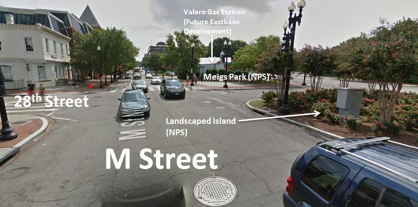
, as well as combined where sharing site features (e.g. where they form the Meigs Park and the landscaped island just opposite to the west).")
11 Street View: Key Bridge and M Street looking southeast 3. M Street: This entrance point and Pennsylvania Avenue converge as a major eastern entrance point to Georgetown from downtown DC. M Street should be considered individually where distinctly separate from Pennsylvania Avenue (e.g. the bridge landing points), as well as combined where sharing site features (e.g. where they form the Meigs Park and the landscaped island just opposite to the west). Site includes: light poles on the M Street bridge for banners; the sidewalk and park on the north side of M Street at the western end of the M Street bridge; the sidewalk on the south side of M Street at the western end of the M Street bridge and the grounds of the future Eastbanc development on the site of the current Valero gas station; Meigs Park bounded by M Street, 28 th Street, and Pennsylvania Avenue, which is controlled by NPS; and the landscaped island west of Meigs Park, also controlled by NPS. 4. Pennsylvania Avenue: Site includes the light poles on the Pennsylvania Avenue bridge for banners; the sidewalk on the north side of Pennsylvania Avenue at the western end of the bridge and the grounds of the future Eastbanc development on the site of the current Valero gas station; the sidewalk on the south side of Pennsylvania Avenue at the western end of the bridge between the Four Seasons Washington, D.C. and the Rock Creek Trail entrance; Meigs Park bounded by M Street, 28 th Street, and Pennsylvania Avenue, which is controlled by NPS; and the landscaped island west of Meigs Park, also controlled by NPS. 11


12 Overhead View: M Street and Pennsylvania Avenue Street View: M Street looking west 12

13 Street View: M Street looking south Street View: M Street looking east 13


14 Street View: Pennsylvania Avenue looking west Street View: Pennsylvania Avenue looking east 14

15 5. Wisconsin Avenue: This entrance into the Book Hill area at the north end of Georgetown is a different scale than the others and includes a mix of small commercial and adjacent residential. The beginning of the Georgetown BID area is the intersection of Wisconsin Avenue and R Street at the Georgetown Library. This intersection may be the most appropriate for a gateway element though opportunities also exist along Wisconsin Avenue near the intersections of Wisconsin Avenue, Reservoir Road, and 33 rd Street. Overhead View: Wisconsin Avenue between R Street and Reservoir Road 15


16 Street View: Wisconsin Avenue at R Street looking south Street View: Wisconsin Avenue at Reservoir Road looking south Gateway Design Elements The design goal is to develop a kit of parts that can be selectively applied in different ways appropriate to each unique Gateway; not all elements would be used at all locations and some locations may only require one or two elements depending on the nature of the site. These elements should have a consistency and 16
17 intelligibility across the program, and be unique to Georgetown. The program will be developed to facilitate phasing either by phasing in elements across all locations or phasing by location with all design elements for that location. 1. Entrance Marker The entrance marker may be a sign, sculpture, structure, pylon, or other element that announces arrival in Georgetown. The marker should have a unique historical/cultural connection to Georgetown as well as inclusion of its founding date of 1751, and be viewable from 360 degree. Entrance markers should be similar at each gateway but may vary in scale and/or the specific design details at each site as appropriate. Markers should be illuminated at night and be readable at both a pedestrian and vehicular scale. 2. Wayfinding and Historical Content One of the most important elements at entrance points primarily for pedestrian and bicyclist use - is one which communicates location, orientation, wayfinding, and historic context. The execution of this element could be similar to the District of Columbia s Heritage Trail Program signs. The signage should allow for content on two sides, one which includes a pedestrian-scale map that orients visitors to where they are and identifies major destinations in Georgetown. The opposite side would have general historical content about the Georgetown neighborhood overall and could form the introduction to a later extension of the program along major thoroughfares and about specific landmark sites. The Georgetown BID will develop the content with community stakeholders through a separate process. 3. Site Furnishings Site furnishing could include seating for resting and orientation for bicyclists and pedestrians before continuing into Georgetown. 4. Lighting Enhancement 17
18 Lighting enhancement could include provisions to add lighting to gateway elements, the ground plane, and landscaping to draw attention at night, but at a scale and intensity appropriate for a historic district. 5. Landscape Enhancement Certain areas at Gateways will be identified where landscaping could be improved or expanded with shrubs, flowering plants, trees, and other plantings. Designs for landscape enhancements should consider ease of maintenance, hardiness, and coordination with existing flower baskets on light poles in the commercial district. 6. Banners Limited use of banners can offer a great opportunity for communication and visual stimulus. Banners could be mounted to two to four bridge light poles at the end of the bridges (Key Bridge, M Street, and Pennsylvania Avenue) leading into Georgetown, but just outside the historic district. They could allow for permanent signage and for rotational fabric to advertise seasonal content related to activities or special events in Georgetown. Precedent Images The following images serve as examples of existing placemaking and gateway elements in Georgetown, existing gateways elsewhere in the District, and the design elements in the kit of parts. These examples are not meant to constrain proposed designs or dictate the nature of Georgetown gateways elements but rather to serve as a point of reference for existing gateway elements. 18


19 Existing GBID-sponsored placemaking elements: flower baskets, holiday lighting on street trees in Meigs Park, and holiday decorations on light poles Former and existing signs identifying the threshold of Georgetown and destinations within Georgetown: Old Georgetown Historic District, Georgetown University, and the C&O Canal National Historic Park Entrance markers for other neighborhoods in the District of Columbia: Glover Park, Park View, and LeDroit Park 19


20 Light pole banners and signs for other DC neighborhoods: H Street NE, NoMa, and Mount Pleasant Gateway markers and orientation/wayfinding wall and street elements in Brooklyn 20

21 DC Heritage Trail Signs Project Budget for Design Services and Deliverables The maximum project budget for Phase 1 Design Services is $75,000. Any remaining funds from this appropriation will be added to potential future construction costs in Phase 2. The scope of design services includes the following: 1. After award of contract, meet with GBID and the Gateways Committee for an initial meeting to review program, approach, design ideas, and scope. 2. Visit sites, develop appropriate plans, and site documentation on-site and as may be available from various DC sources. 3. Provide a comprehensive design plan for the five primary gateways that is presentation-ready for the Georgetown BID to use to secure permits. Each gateway location does not require the same number or scale of design elements. Assume the following submissions (with hard copies and electronic media) each followed by a presentation/meeting to GBID/Gateways Committee: Concept, Schematic Design, Design Development, and Construction/Permit/Bid Documents. GBID staff may schedule conference calls with the Design Team as needed between each meeting with the Gateways Committee. Both the Design Team and GBID staff will be available by phone and during the normal work week. 21
22 4. Provide recommendations for complementary design elements appropriate for each secondary gateway. Applicants do not need to provide comprehensive design plans for the secondary gateways at the same level of design as for the primary gateways. 5. Provide cost estimates for construction of proposed design, starting with the Schematic Design Submission and updated with each subsequent submission. 6. Provide a maintenance plan for the proposed design elements in the final design plan. 7. Provide a damaged design element repair plan for the proposed design elements in the final design plan. 8. Provide two public presentations to necessary regulatory agencies to secure approvals and permits. 9. Include the appropriate Consultants required to complete the scope of the services, which may include Structural, Electrical, Civil, and Landscape. 10. Construction Administration Services will be defined and engaged as Phase 2. It is anticipated that implementation of the designs will be phased depending on the availability of funding. The GBID may seek additional funding for fabrication upon the completion of the designs. Eligibility This RFP is open to all professional design teams with practices located within a 50 mile radius of Washington, DC, with successful past experience working in historic districts, with a preference for firms familiar with Georgetown and the relevant review agencies and stakeholders. Selection Process The Georgetown BID has convened a Georgetown Gateways Committee comprising business, community, and government stakeholders that will review proposals and may select up to five (5) firms to be interviewed in person. These firms are encouraged to bring to the interview initial conceptual ideas and relevant past 22
23 precedents, but are not required to create designs or renderings for the interview. From these interviews a finalist will be chosen to serve as a design partner with the GBID to develop final designs and implementation options for each site in collaboration with business, community, and government stakeholders. Selection Criteria A practicing design professional supported by the appropriate consultants and disciplines necessary to complete the scope of this work. Demonstrated artistic and design excellence in comparable projects through innovation and originality as evidenced in previous work. Experience working in historic districts. Experience working in or a familiarity with Georgetown and its local regulatory and review processes (including the District of Columbia government, U.S. Commission of Fine Arts Old Georgetown Board, and National Park Service) is a plus. Ability to complete the commission as required by the project schedule. Experience, availability, and willingness to participate in a community stakeholder process to develop consensus design solutions, including incorporating comments from community stakeholders and participating in public meetings separate from the entitlements process. Previous work that demonstrates structural and surface soundness, durability, ability to withstand public interaction, resistance to vandalism, weathering, excessive maintenance, and excessive repair costs. Previous work is appropriate for placement on an urban pedestrian site and in a historic context. Proven track record of completing work on time and within budget. Preliminary Timeline Request for Proposals Released: November 4, 2016 Proposals Due: November 30, 2016 Gateways Committee Notifies Finalists: December 9, 2016 Gateways Committee Interviews: December 14-16,
24 Selected Team Notified: December 21, 2016 Collaborative Design Process: January June 2017 Construction and Installation: Design and Approval Process The Georgetown Gateways Committee comprises representatives of the business community, architectural community, Advisory Neighborhood Commission 2E (ANC), the Citizens Association of Georgetown, the National Park Service, the District Department of Transportation, the DC Office of Planning, Georgetown University, and the Old Georgetown Board of the US Commission of Fine Arts. The Federal Highway Administration (FHWA) may also comment on designs related to the Whitehurst Freeway. The Gateways Committee will meet on a semi-regular basis with the finalist to develop consensus designs that will satisfy the requirements of the above District and federal regulatory agencies. The entitlements process may include a Preliminary Design Review Meeting (PDRM) with DDOT and OP, public presentations to the DDOT Public Space Committee, public presentations to the ANC, and public presentations to the OGB. Applicants should expect to make two public presentations and should provide completed plans that the Georgetown BID can use in additional public presentations necessary to secure final regulatory approval. The GBID has the discretion to implement the designs through a phased approach as funding becomes available. Design Guidelines Designs will be compatible in scale and format to the site and the historic character of the neighborhood. Designs must be understandable at a pedestrian, bicycle, and vehicular scale. Proposals must consider the surrounding community and not impede current bicycle, vehicle, or pedestrian uses of the spaces. Proposals must ensure the design elements will be durable, resistant to vandalism and weathering, easy to maintain, and safe for the public. 24
25 Proposals may undergo a security review by local transportation, historic preservation, and public safety authorities. The District Department of Transportation (DDOT) has regulatory oversight with respect to construction activities in public space within the District of Columbia. Final installations shall comply with the relevant DDOT standards, including those found within the DDOT Public Realm Design Manual and the DDOT Design and Engineering Manual. Designs may also require a Preliminary Design Review Meeting (PDRM) with DDOT and the DC Office of Planning and review by the DDOT Public Space Committee. The National Park Service has regulatory oversight over NPS property and may require that installations comply with NPS design guidelines. Submission Requirements 1. Application Form: Please complete the cover application form on page 28. If you would prefer to type your information, please include the following: full Legal Name (and other Professional Name as applicable), Address, Daytime Telephone, Evening Telephone, Address, and Website (optional). 2. Cover letter: Describe how this project relates to your past work and how you would approach the project. This letter should not exceed two (2) pages. 3. Firm Information a. Provide primary contact information for your firm. b. Provide a brief description and history of your firm, including size, location(s), notable accomplishments and awards, and current number of employees. Please identify the office that will serve this project. c. Provide the following for company principals and design team: names, biographies, special qualifications, recognitions, and awards. d. Describe the firm s overall approach and unique talent qualifications for this project. e. Disclose any current legal actions, suits, litigation, or settlements 25
26 reached in the last five (5) years in excess of $50,000. f. Provide three (3) references, to include a combination of both recent clients and professional relationships. References shall include accurate current contact information. 4. Proposed Budget a. Provide a detailed explanation of your design fee, including any subconsultants, meetings, and presentations 5. Proposed Team Structure a. Provide an overall explanation of your team structure including subconsultants, and team member roles and responsibilities. b. Describe the qualifications of key individuals assigned to this project. 6. Representative Projects Relevant Experience a. Provide all relevant information pertaining to your firm s experience with urban planning and public space projects, involving comparable urban streetscape elements. b. Provide three to five (3-5) sample projects representing a similar scope, complexity, and program and include relevant details, including completion date, institution name and location, descriptions/photographs, proposed and actual budget. Submission Deadline Submissions must be received by 5:00 PM (EST) on November 30, Submissions received after the deadline will not be accepted. How to Apply Applicants should submit all materials to: Georgetown Business Improvement District ATTN: Georgetown Gateways Project 26
27 1000 Potomac Street, NW, Suite 122 Washington, DC Other Requirements Selected Designer or Team will: Enter into an agreement with the GBID for the duration of the project. For the duration of the contract the design team will be required to maintain all relevant licenses and carry appropriate professional liability insurance. Work with the GBID to determine the best strategy for final documentation required to execute fabrication and installation of the artwork. Work with recommended contractors, vendors, fabricators and installers, obtain cost estimates, and develop fabrication and installation schedules. Keep a list of itemized expenses and purchase or service receipts for auditing and financial reporting purposes, and for payment of reimbursable expenses. Rights and Responsibilities The GBID has the right to cancel this RFQ and/or decline any or all RFQ submissions. All materials provided under contract to the GBID will be considered the property of the GBID and are for its exclusive use. Publicity The GBID will produce marketing and event materials related to any dedication ceremonies and include the Design Team s information on the GBID website, social media, and other media outlets as necessary. A weather-proof plaque or label with pertinent information and GBID approved text will be installed along with the design elements. The GBID may host a public dedication ceremony upon installation of the design elements at each gateway. The GBID reserves the right to photograph the artwork for educational purposes, brochures, and other publicity. In all printed materials, the Georgetown BID will make every effort to credit the designer and/or design team. 27
28 Application Form Georgetown Business Improvement District Request for Proposals - Georgetown Gateways Project Applicant s Name(s): Mailing Address: City: State: Zip code: Phone: Mobile (optional): address: Web site (optional): Deadline: Submissions must be received by 5:00 PM EST on November 30, Application checklist: Application Form Cover Letter Firm Information Fee Structure CV/Resume(s) of Principals and Designers At least three Professional References Team Structure Three to five sample projects 28
Call for Artists Gateway Island Ashland Oregon Requests for Qualifications (RFQ)
") Call for Artists Gateway Island Ashland Oregon Requests for Qualifications (RFQ) The Project The Ashland Public Art Commission (PAC) seeks an artist, or artist team, to develop a site specific, permanent,
Call for Artists Gateway Island Ashland Oregon Requests for Qualifications (RFQ) The Project The Ashland Public Art Commission (PAC) seeks an artist, or artist team, to develop a site specific, permanent,
MY BILL OF RIGHTS.ORG COMMISSIONING GUIDELINES & STANDARDS VISION AND PROCESS
 MY BILL OF RIGHTS.ORG CELEBRATING AMERICA S FOUNDING FREEDOMS THE BILL OF RIGHTS MONUMENT PROJECT A LEGACY OF LANDMARK INSTALLATIONS ART AND INSPIRATION IN OUR PUBLIC SQUARE COMMISSIONING GUIDELINES &
Posted by Calgary Public Library on November 1, 2012
 Call to Artists for Signal Hill Library Public Art Project Posted by Calgary Public Library on November 1, 2012 Eligibility This project is open to local and regional artists. Emerging and established
Request for Proposal
 Request for Proposal 10 th Street Corridor Master Plan Department of Planning and Zoning 500 Quartermaster Court Suite 200 Jeffersonville, IN 47130 April 18, 2017 For further information contact: Chad
Downtown Cleveland s Main Avenue Bridge
 Downtown Cleveland s Main Avenue Bridge Underpass Improvement Competition Project Summary Downtown Cleveland Alliance seeks a creative professional or team (architect, designer, artist, engineer, landscape
REQUEST FOR QUALIFICATIONS
 REQUEST FOR QUALIFICATIONS for the City of Lake Forest Issue Date: September 23, 2015 Bid Due Date: October 19, 2015 The City of Lake Forest 800 N. Field Drive Lake Forest, Illinois 60045 THE CITY OF LAKE
Public Art Guidelines And Public Art Donation Program
 Public Art Guidelines And Public Art Donation Program Adopted by City Council Resolution No. 3787 October 12, 2004 Ordinance No. 557 October 26, 2004 Amended by City Council Resolution No. 4411 November
A Better City Request for Qualifications
 A Better City Request for Qualifications Urban design proposal for the pedestrianization of Birch Street in Roslindale December 13, 2018 Responses preferred by January 8, 2019 at 11:59pm Eastern Time Request
In March 2012, the County of Yolo was awarded a grant from the California State Department of Parks
 Request for Proposals (RFP) Deadline for Submittal: January 23, 2019 The County of Yolo wishes to expand the public s experience with the visual arts; to make available artwork of the highest quality to
WOONASQUATUCKET RIVER WATERSHED COUNCIL REQUEST FOR PROPOSALS DESIGN OF GREENWAY PALETTE, SIGNAGE AND AMENITIES
 WOONASQUATUCKET RIVER WATERSHED COUNCIL REQUEST FOR PROPOSALS DESIGN OF GREENWAY PALETTE, SIGNAGE AND AMENITIES PROJECT BACKGROUND The Woonasquatucket River Watershed Council (WRWC) is a 501(c)3 organization
CITY OF CHARLOTTESVILLE, VIRGINIA CITY COUNCIL AGENDA
 CITY OF CHARLOTTESVILLE, VIRGINIA CITY COUNCIL AGENDA Agenda Date: December 16, 2013 Action Required: Adoption of Resolution Presenter: Staff Contacts: Title: James E. Tolbert, AICP, Director of NDS James
Scope of Services. River Oaks Boulevard (SH 183) Corridor Master Plan
 Corridor Master Plan") Scope of Services River Oaks Boulevard (SH 183) Corridor Master Plan PROJECT AREA The project area consists of the River Oaks Boulevard (SH 183) corridor bounded by SH 199 at the northern end and the Trinity
Scope of Services River Oaks Boulevard (SH 183) Corridor Master Plan PROJECT AREA The project area consists of the River Oaks Boulevard (SH 183) corridor bounded by SH 199 at the northern end and the Trinity
RIVERWALK EAST PUBLIC ART DESIGN PROJECT
 RIVERWALK EAST PUBLIC ART DESIGN PROJECT PREFACE In August 2018, Mayor Rahm Emanuel announced plans to improve the east end of the Chicago Riverwalk. These improvements are part of ongoing efforts to build
Carson Street Streetscape Improvements. Request for Proposals
 Carson Street Streetscape Improvements Request for Proposals Complete Design Services for a Landscape/Streetscape Plan for Carson Street (Pioneer Boulevard to Norwalk Boulevard) Submittal Deadline: October
V. Gateways GATEWAYS / V-1
 V. GATEWAYS / V-1 Many of Chesapeake s gateways are located on highways and call for bold and attractive designs that motorists can understand, appreciate, and enjoy. can also take the form of natural
Request for Qualifications. Knowledge Park Pedestrian/Cyclist Connectivity Planning and Design
 PUR872 I. Invitation Request for Qualifications Knowledge Park Pedestrian/Cyclist Connectivity Planning and Design The City of Rock Hill is requesting Statements of Qualifications from interested and qualified
Welcome. Walk Around. Talk to Us. Write Down Your Comments
 Welcome This is an information meeting introducing the applications for proposed redevelopment of the Yorkdale Shopping Centre site at 3401 Dufferin Street and 1 Yorkdale Road over the next 20+ years,
The transportation system in a community is an
 7 TRANSPORTATION The transportation system in a community is an important factor contributing to the quality of life of the residents. Without a sound transportation system to bring both goods and patrons
Request for Proposals: Architectural/Design Guidelines
 Request for Proposals: Architectural/Design Guidelines January 11, 2017 1.0 INTRODUCTION The City of Issaquah, Washington is soliciting proposals from qualified consulting firms to lead a community conversation
CALL TO ARTISTS Expression of Interest (EOI)
") City of Mississauga Culture Division 201 City Centre Drive, Ste 202 MISSISSAUGA ON L5B 2T4 mississauga.ca CALL TO ARTISTS Expression of Interest (EOI) Public Artwork for Mavis Road Bridge Submission Deadline:
City of Mississauga Culture Division 201 City Centre Drive, Ste 202 MISSISSAUGA ON L5B 2T4 mississauga.ca CALL TO ARTISTS Expression of Interest (EOI) Public Artwork for Mavis Road Bridge Submission Deadline:
New York Avenue Streetscape and Trail Project Public Meeting #1 Summary
 New York Avenue Streetscape and Trail Project Public Meeting #1 Summary I. King Jordan Student Academic Center (SAC) Gallaudet University, Washington, DC February 23, 2017 Table of Contents 1.0 Introduction...
The Village of Sugar Grove, in partnership with Kane County, the Illinois Department of Transportation, and the Illinois Tollway welcomes you to the
 The Village of Sugar Grove, in partnership with Kane County, the Illinois Department of Transportation, and the Illinois Tollway welcomes you to the first Public Meeting for the proposed interchange improvement
HISTORIC SITE AND MONUMENT COMMISSION (HSMC) Instructions for Historical Markers, Monuments, and Public Art Application
 Instructions for Historical Markers, Monuments, and Public Art Application") HISTORIC SITE AND MONUMENT COMMISSION (HSMC) Instructions for Historical Markers, Monuments, and Public Art Application This document is for information purposes only and does not need to be submitted
HISTORIC SITE AND MONUMENT COMMISSION (HSMC) Instructions for Historical Markers, Monuments, and Public Art Application This document is for information purposes only and does not need to be submitted
TERMS OF REFERENCE. General
 General TERMS OF REFERENCE City of Guelph is inviting experienced, professional artists or a team of artists to prequalify for the opportunity to develop new public art work. The total all-inclusive budget
People who are members of historically disenfranchised racial, ethnic, cultural, and other identity groups are encouraged to apply.
 CALL TO ARTISTS REQUEST FOR QUALIFICATIONS CITY OF TACOMA MUNICIPAL ART PROGRAM East 64 th Streetscape, Tacoma, WA APPLICATION DEADLINE October 10, 2018, 11:59pm BUDGET $72,000, all-inclusive SUMMARY The
RESOURCE PACKET River Crossing
 RESOURCE PACKE River Crossing Overall Project Focus: "River Crossing" project is funded through an NEA Our own grant that provides a comprehensive plan for public art and arts experiences that will connect
City of Mequon and Village of Thiensville Community Gateway Features Request for Qualifications
 City of Mequon and Village of Thiensville Community Gateway Features Request for Qualifications Prepared by: Pa Phouala Vang Date: October 20, 2017 RFQ NO.: Sponsor: 2017-1 Community Gateway Features Mequon-Thiensville
City of Havana, Prairieland Community Development & 353 Court LLC
 City of Havana, Prairieland Community Development & 353 Court LLC RFP for Havana Art Project September 4, 2018 CALL FOR ENTRY: Art Installations on Buildings in Historic Downtown Havana, Illinois Application
Jefferson Street Pedestrian Tunnel Mural Project 2018
 Milwaukee Downtown Placemaking Task Force & Milwaukee Downtown, BID #21 Jefferson Street Pedestrian Tunnel Mural Project 2018 Mural Invitational Request for Qualifications (RFQ) Issue Date: Wednesday,
PUBLIC ART COMMISSION TOWN OF PELHAM Public Art Installation as a Gateway Feature Stage 2: Competition Brief for Public Art Proposals
 PUBLIC ART COMMISSION TOWN OF PELHAM Public Art Installation as a Gateway Feature Stage 2: Competition Brief for Public Art Proposals The Town of Pelham has issued this Competition Brief as Stage 2 of
Urban Design 9Identity
 Urban Design 9Identity URBAN DESIGN IDENTITY Urban design is about connecting people to their places through the built environment, nature, and overall urban form. Done well, it creates a memorable space
Mark-up of the effect of the proposed Bronte Village Growth Area OPA No.18 on the text of section 24, Bronte Village, of the Livable Oakville Plan
 Mark-up of the effect of the proposed Bronte Village Growth Area OPA No.18 on the text of section 24, Bronte Village, of the Livable Oakville Plan Notes: This document is provided for information purposes
TEMPLE MEDICAL & EDUCATION DISTRICT
 City of Temple, Texas TEMPLE MEDICAL & EDUCATION DISTRICT 1 Description. The City of Temple joined in partnership with key public and private entities to jointly promote education and medical activities
PUBLIC ART CALL LIONS GATE COMMUNITY CENTRE. For Expressions of Interest Submission Deadline: March 18, 2018 Project Value: $85,000(inclusive)
") LIONS GATE COMMUNITY CENTRE PUBLIC ART CALL For Expressions of Interest Submission Deadline: March 18, 2018 Project Value: $85,000(inclusive) LGCC EOI 1 LIONS GATE COMMUNITY CENTRE (LGCC) PUBLIC ART CALL
LIONS GATE COMMUNITY CENTRE PUBLIC ART CALL For Expressions of Interest Submission Deadline: March 18, 2018 Project Value: $85,000(inclusive) LGCC EOI 1 LIONS GATE COMMUNITY CENTRE (LGCC) PUBLIC ART CALL
The City of Bowie Arts Committee Bowie, Maryland ART IN PUBLIC PLACES PROGRAM Request for Proposals
 The City of Bowie Arts Committee Bowie, Maryland ART IN PUBLIC PLACES PROGRAM Request for Proposals Deadline for Submission: September 1, 2016. 5 p.m. EDT Background The City of Bowie announces a Request
CALL FOR ARTIST QUALIFICATIONS SUBMISSIONS. DIA Urban Arts Projects Phase One
 CALL FOR ARTIST QUALIFICATIONS SUBMISSIONS DIA Urban Arts Projects Phase One ART IN PUBLIC PLACES City of Jacksonville, Florida Submissions Due March 31, 2016, midnight MST Through CAFÉ: callforentry.org
OVERMOUNTAIN VICTORY TRAIL BURKE CALDELL CORRIDOR FEASIBLITY STUDY REQUEST FOR QUALIFICATIONS CALDWELL COUNTY PATHWAYS
 OVERMOUNTAIN VICTORY TRAIL BURKE CALDELL CORRIDOR FEASIBLITY STUDY REQUEST FOR QUALIFICATIONS CALDWELL COUNTY PATHWAYS Caldwell County Pathways along with our co-partners City of Lenoir, Town of Gamewell,
Report to: Development Services Committee Report Date: April 24, 2017
 SUBJECT: Cornell Rouge National Urban Park Gateway - Report on Design Charrette and Next Steps PREPARED BY: Lilli Duoba, MES, MCIP, RPP, Manager, Natural Heritage (ext. 7925) REVIEWED BY: Marg Wouters,
Chapter 7: Streetscape & Design Elements
 OVERVIEW Chapter 7: Streetscape & Design Elements During the public input phase of The Dixie Fix, the area of streetscape generated much interest. While safety and traffic flow are primary objectives of
5.0 WAYFINDING STREETSCAPE DESIGN MASTER PLAN 55
 OVERVIEW 57 SIGN TYPE A: GATEWAY 57 SIGN TYPES B & C: WAYFINDING KIOSKS & BOLLARDS 58 SIGN TYPES D: POLE MOUNTED ELEMENTS 59 SIGN TYPE E: LARGE-SCALE TYPOGRAPHIC INSTALLATION 60 SIGN TYPE F: VERTICAL CHOPSTICKS
Call to Artists Public Art for Los Angeles Metro Stations
 Conceptual Design for Call to Artists Public Art for Los Angeles Metro Stations Artesia Transit Center Union Station/Patsaouras Transit Plaza Los Angeles County Metropolitan Transportation Authority February
City of North Vancouver
 City of North Vancouver PUBLIC ART CALL For Expressions of Interest Mosquito Creek Trail (Bridge Underpass) Deadline: November 10, 2017 @ 4 pm Public Art Mosquito Creek (bridge underpass) Call for Expressions
RESOLUTION NO. R Refining the route, profile and stations for the Downtown Redmond Link Extension
 RESOLUTION NO. R2018-32 Refining the route, profile and stations for the Downtown Redmond Link Extension MEETING: DATE: TYPE OF ACTION: STAFF CONTACT: Capital Committee Board PROPOSED ACTION 09/13/2018
REQUEST FOR PROPOSALS
 REQUEST FOR PROPOSALS To develop a signage master plan for the Bronx River Greenway and Blueway. Table of Contents Section I - Timetable Section II Summary of the RFP Section III Scope of Work Section
STAFF REPORT Agenda Item: J.4 To: Mayor and City Council Date:
 STAFF REPORT Agenda Item: J.4 To: Mayor and City Council Date: 2-14-2007 Thru: Charles McNeely, City Manager Subject: Staff Report: Approval of a project to be submitted for the NDOT 2007-2009 Landscape
CHAPTER 5 Public Realm Improvements
 5.1 OVERVIEW This chapter focuses on the public realm, that is, spaces within and directly adjacent to public rights-of-way (ROWs), including streets, Oso Creek, the rail corridor, and the freeway edge.
RFP/RFQ. for Concept & Schematic Design Services. for Outdoor Garden Enhancements. to Cleveland Botanical Garden
 RFP/RFQ for Concept & Schematic Design Services for Outdoor Garden Enhancements to Cleveland Botanical Garden Process facilitated by Smithink Distributed: October 30, 2012 Responses Due by: November 21,
6-GATEWAYS, WAYFINDING & PUBLIC SIGNS
 6-GATEWAYS, Wayfinding & ublic Signs 6-GATEWAYS, WAYFINDING & UBLIC SIGNS Downtown Georgetown has a strong base of local users as well as seasonal tourists and visitors. Many first-time visitors, and those
Request for Qualifications For Administration of the 2016 Summer Sprout Program
 Page 1 of 6 Request for Qualifications For Administration of the 2016 Summer Sprout Program Requested by: City of Cleveland, Department of Community Development 601 Lakeside Avenue, room 320 Cleveland,
1.0 Purpose of a Secondary Plan for the Masonville Transit Village
 Report to Planning and Environment Committee To: Chair and Members Planning & Environment Committee From: John M. Fleming Managing Director, Planning and City Planner Subject: Masonville Transit Village
The Illinois Department of Transportation and Lake County Division of Transportation. Route 173, including the Millburn Bypass
 The Illinois Department of Transportation and Lake County Division of Transportation welcome you to this Public Hearing for U.S. Route 45 from Illinois Route 132 to Illinois Route 173, including the Millburn
38 Queen s University Campus Master Plan Part 1
 38 Queen s University Campus Master Plan Part 1 46 The Campus at the City Scale Chapter 4 The Campus at the City Scale 39 Queen s is an urban University centrally located in Kingston. Decisions made by
DOWNTOWN NORFOLK COUNCIL ACTION PLAN. Strategic Initiatives Focus Area Objectives. Departmental Focus Area Key Objectives
 DOWNTOWN NORFOLK COUNCIL ACTION PLAN FY18 Strategic Initiatives Focus Area Objectives Departmental Focus Area Key Objectives STRATEGIC INITIATIVES FOCUS AREA OBJECTIVE #1: NURTURE A VIBRANT URBAN ENVIRONMENT
Western Pennsylvania Conservancy Clairton & Harrison Community Greening Assessment Projects Request for Proposals July 2018
 Western Pennsylvania Conservancy Clairton & Harrison Community Greening Assessment Projects Request for Proposals July 2018 Proposal Information The Western Pennsylvania Conservancy (WPC) is seeking proposals
Request for Proposals Design Services for Kitchen Remodel and Second Floor Layout
 Request for Proposals Design Services for Kitchen Remodel and Second Floor Layout I. About the Agency StopWaste helps Alameda County s businesses, residents and schools waste less, recycle more and use
North Fair Oaks Community Plan Summary and Information
 North Fair Oaks Community Plan Summary and Information WHAT IS THE NORTH FAIR OAKS COMMUNITY PLAN? The North Fair Oaks Community Plan is part of the San Mateo County General Plan, and establishes policies
Request for Proposals (RFP) Consultant Services for the Muckleshoot Placemaking and Landscape Visual Design Services; Campus/Village Planning Project
 Consultant Services for the Muckleshoot Placemaking and Landscape Visual Design Services; Campus/Village Planning Project") Request for Proposals (RFP) Consultant Services for the Muckleshoot Placemaking and Landscape Visual Design Services; Campus/Village Planning Project To assist the Muckleshoot Indian Tribe by: 1) Providing
Request for Proposals (RFP) Consultant Services for the Muckleshoot Placemaking and Landscape Visual Design Services; Campus/Village Planning Project To assist the Muckleshoot Indian Tribe by: 1) Providing
University of the District of Columbia Van Ness Campus Master Plan Community Open House 3. December 8, 2010
 University of the District of Columbia Van Ness Campus Master Plan Open House 3 December 8, 2010 Introductions Sequence of Work: Campus Master Plan BEGIN: INTRODUCE AND START WORK Project Initiation Team
Sheridan Boulevard S TAT I O N A R E A P L A N S H E R I D A N B O U L E VA R D S TAT I O N A R E A P L A N
 Sheridan Boulevard S TAT I O N A R E A P L A N 1 City of Lakewood Adopted November, 2006 S H E R I D A N B O U L E VA R D S TAT I O N A R E A P L A N The Vision The City of Lakewood s overall vision is
REQUEST FOR QUALIFICATIONS
 REQUEST FOR QUALIFICATIONS VILLAGE OF HAMBURG COMPREHENSIVE ZONING/LAND USE REGULATIONS UPDATE Prepared By: Village of Hamburg 100 Main Street Hamburg, New York 14075 Village of Hamburg RFQ Page 1 of 10
Call for Artists for: Design and Construction of Environmental Art Activation Story Mill Community Park, Bozeman, MT
 Call for Artists for: Design and Construction of Environmental Art Activation Story Mill Community Park, Bozeman, MT Seeking artists to design, fabricate and install art elements in the nature sanctuary
City of Ashland. Attn: Laura Loucks; Sustainability Intern 601 Main Street West Ashland, WI
 City of Ashland REQUEST FOR PROPOSALS RFP #18-01 Artistic Solar Public Art Project April 4, 2018 The City of Ashland, Wisconsin will be receiving proposals for the above noted project until Friday, June
Table of Contents. Elm Avenue Improvement Plan City of Waco, Texas. Introduction 1. Existing Context 1 Figure 1 2.
 Table of Contents Introduction 1 Existing Context 1 Figure 1 2 Plan Guidelines 3 Future Urban Form 4 The West-End 4 Main Street 6 The East-End 7 Figure 2 9 Public Improvement Recommendations 7 General
A. Project Description
 University of Wisconsin Eau Claire RFQ Letter of Interest On behalf of the University of Wisconsin-Eau Claire, qualified firms who are interested in providing Design and Construction Services for a new
Public input has been an important part of the plan development process.
 Lakewood s Comprehensive Plan recognizes that transportation helps shape the community, and that the way the community provides for the safe and efficient movement of people affects the character of the
CALL TO ARTISTS: REQUEST FOR QUALIFICATIONS
 CALL TO ARTISTS: REQUEST FOR QUALIFICATIONS CALL TO ARTISTS: REQUEST FOR QUALIFICATIONS Public Artwork for Haymarket Plaza: Eau Claire, WI Proposals due: October 29th, 2018 Summary / Description of Haymarket
WELCOME TO THE CHOUTEAU GREENWAY DESIGN, DEVELOPMENT AND CONSTRUCTION WORKING GROUP!
 WELCOME TO THE CHOUTEAU GREENWAY DESIGN, DEVELOPMENT AND CONSTRUCTION WORKING GROUP! Chouteau Greenway Steering Committee and Working Groups Overview Overview January 9, 2019 Chouteau Greenway will transform
Memorials, Plaques & Interpretive Signs Policy
 Memorials, Plaques & Interpretive Signs Policy APPROVAL COUNCIL DATE / CEO VERSION NO: Version 0.4 TRIM REF: 16/31097 REVIEW 30 June 2020 RESPONSIBLE EXECUTIVE General Manager City Assets & Environment
Building Exterior Lighting Grant Program. Applications will be reviewed April 1, July 1 and October 1, 2019
 Building Exterior Lighting Grant Program Applications will be reviewed April 1, July 1 and October 1, 2019 Table of Contents Building Exterior Lighting Grant Program Program Information Background... 3
Issues Requiring Future Study
 Issues Requiring Future Study Transportation planning is an ongoing process that tends to identify new issues as it finds solutions for others. Some issues are so complex that a solution to one problem
WELCOME TO THE CHOUTEAU GREENWAY EQUITY WORKING GROUP!
 WELCOME TO THE CHOUTEAU GREENWAY EQUITY WORKING GROUP! Chouteau Greenway Steering Committee and Working Groups Overview Overview January 9, 2019 Chouteau Greenway will transform St. Louis by connecting
Request for Proposals
 Request for Proposals Charlestown Navy Yard Infrastructure Assessment Engineering Services The Boston Redevelopment Authority ( BRA )/Economic Development Industrial Corporation ( EDIC ) is issuing a Request
July 12, Columbus City Council City Hall 90 West Broad Street Columbus, OH RE: I-70/71 Columbus Crossroads Project
 OHIO DEPARTMENT OF TRANSPORTATION DISTRICT 6 400 EAST WILLIAM STREET DELAWARE, OHIO 43015 800.372.7714 Columbus City Council City Hall 90 West Broad Street Columbus, OH 43215-9015 RE: I-70/71 Columbus
Campus Sign Plan. Adopted by the Campus Planning Committee Adopted: June 26, 2006 Revised: April 14, 2016
 Campus Sign Plan Adopted by the Campus Planning Committee Adopted: June 26, 2006 Revised: April 14, 2016 INTRODUCTION Oregon State University requires an effective system of visual communication that projects
Q:%4~ Memorandum CITY OF DALLAS
 Memorandum DATE December 10, 2010 CITY OF DALLAS TO Members of the Transportation and Environment Committee: Linda Koop (Chair), Sheflie Kadane (Vice Chair), Pauline Medrano, Vonciel Jones Hill, Jerry
Urban Design Review Panel Terms of Reference
 Urban Design Review Panel Terms of Reference 1. Background The City of Brampton is initiating an Urban Design Review Panel (UDRP) on a pilot basis for two years starting March 2018, following the endorsement
Corridor Vision. 1Pursue Minnehaha-Hiawatha Community Works Project. Mission of Hennepin County Community Works Program
 1Pursue Minnehaha-Hiawatha Community Works Project Minnehaha-Hiawatha Community Works is a project within the Hennepin Community Works (HCW) program. The mission of the HCW program is to enhance how the
PLANNING APPROVAL & SIDEWALK WAIVER STAFF REPORT Date: December 1, 2016
 PLANNING APPROVAL & SIDEWALK WAIVER STAFF REPORT Date: December 1, 2016 NAME Dennis P. Wilkins LOCATION. CITY COUNCIL DISTRICT District 6 7078 Bruns Drive (Northeast corner of Bruns Drive and Cody Road)
implementation r expression in landscape
 6 ubc okanagan implementation campus plan r expression in landscape 68 6 implementation campus plan sections The Campus Plan supports the academic mission, values and commitments of the University by providing
VILLAGE OF BOLTON HERITAGE CONSERVATION DISTRICT PLAN
 Page 1 1. INTRODUCTION AND BACKGROUND 1.1 THE PROJECT VILLAGE OF BOLTON HERITAGE CONSERVATION DISTRICT PLAN TERMS OF REFERENCE The Town of Caledon (Town) is a large, predominantly rural municipality with
CITY OF VAUGHAN EXTRACT FROM COUNCIL MEETING MINUTES OF NOVEMBER 15, 2016
 Item 11, Report No. 38, of the Committee of the Whole, which was adopted without amendment by the Council of the City of Vaughan on November 15, 2016. Regional Councillor Di Biase declared an interest
Town Center (part of the Comprehensive Plan)
") Town Center (part of the Comprehensive Plan) Mercer Island Town Center Looking North (2014) In 1994, a year-long process culminated in a set of design guidelines and code requirements for the Town Center
Town Center (part of the Comprehensive Plan) Mercer Island Town Center Looking North (2014) In 1994, a year-long process culminated in a set of design guidelines and code requirements for the Town Center
Toronto Complete Streets Guidelines
 c. DTAH 58 60 3.1 70 3.2 Performance Measurement 71 3.3 Exceptions Chapter 3 describes the five general steps in the street design process. Not all projects follow these steps, as the number of steps and
REQUEST FOR PROPOSALS FOR PROFESSIONAL DESIGN SERVICES
 REQUEST FOR PROPOSALS FOR PROFESSIONAL DESIGN SERVICES MCINTIRE BOTANICAL GARDEN, INC. P.O. BOX 6224 CHARLOTTESVILLE, VA 22906 LEAD CONTACT: Jill Trischman-Marks PHONE: 434/973-9785 EMAIL: jill.trischman.marks@gmail.com
Montana Rail Link Park
 RESERVATION RIGHTS: The Missoula Public Art Committee is designated to review, advocate and develop public art projects in the City of Missoula. Since 1985, it has strived to develop a formal s structure
WARM SPRINGS PARK MASTER PLAN
 TABLE OF CONTENTS page 1.0 Introduction and Overview 1 2.0 Information Gathering 2 3.0 Conceptual Alternative Development 8 4.0 Master Plan Development 14 5.0 Construction Cost Estimates 19 LIST OF FIGURES
master plan of highways bus rapid transit amendment
 Scope of Work master plan of highways bus rapid transit amendment September 2011 Montgomery County Planning Department M-NCPPC MontgomeryPlanning.org 1 Scope of Work master plan of highways bus rapid transit
10 Implementation. Implementation. Responsibility for Implementation. Blueprint for Bloomsburg. Town of Bloomsburg Comprehensive Plan 10-1
 Implementation 10 Implementation This chapter overviews how to use the comprehensive plan as a land use and programming tool for the Town of Bloomsburg and recommends annual review of the plan by the Town
Project Overview. Fairfax County Parkway Widening Fairfax County. Get Involved. Public Information Meeting. Contact Information
 Get Involved VDOT representatives will review and evaluate information received as a result of this meeting. Please fill out the comment sheet provided in this brochure if you have any comments or questions.
Implementation Guide Comprehensive Plan City of Allen
 Implementation Guide 2030 Comprehensive Plan City of Allen DRAFT 2015 Implementation Guide Allen 2030 Comprehensive Plan INTRODUCTION The Comprehensive Plan serves as a guide for the growth and development
CITY OF SOCORRO, TEXAS REQUEST FOR QUALIFICATIONS FOR PROFESSIONAL LANDSCAPE DESIGN SERVICES FOR PROPOSED MAURO ROSAS PARK
 Trini Lopez Mayor Guillermo Madrid Jr. At Large Maria Reyes District 1 Gloria M. Rodriguez District 2 Mary B. Garcia District 3 / Mayor Pro Tem Jesus Gandara Jr. District 4 Willie Norfleet Jr. City Manager
REQUEST FOR PROPOSAL (RFP)
") REQUEST FOR PROPOSAL (RFP) Title Outdoor Sculpture of Saint Rose Philippine Duchesne Organization Society of the Sacred Heart Closing Date January 10, 2017 Location Jubilee Prayer Garden at the Cathedral
REQUEST FOR PROPOSAL (RFP) Title Outdoor Sculpture of Saint Rose Philippine Duchesne Organization Society of the Sacred Heart Closing Date January 10, 2017 Location Jubilee Prayer Garden at the Cathedral
ELMVALE ACRES SHOPPING CENTRE MASTER PLAN
 ELMVALE ACRES SHOPPING CENTRE MASTER PLAN Contents 1.0 INTRODUCTION... 2 2.0 LOCATION... 2 3.0 EXISTING CONTEXT... 2 4.0 VISION & GUIDING PRINCIPLES... 2 5.0 LAND USE AND BUILT FORM... 4 5.1 St. Laurent
Planning Commission Report
 Planning Commission Report To: From: Subject: Planning Commission Meeting: January 6, 2016 Agenda Item: 8-B Planning Commission David Martin, Planning & Community Development Director Introduction to the
Pedestrian and Bike Bridge LOGO
 6.2.2 Pedestrian and Bike Bridge The proposed pedestrian and bike crossing re-envisions the existing bridge at Pismo Creek on Cypress Street. The bridge is currently underutilized by vehicular through
Town of Borden-Carleton
 Town of Borden-Carleton 20 Dickie Road Borden-Carleton, PEI C0B 1X0 Phone (902) 437-2225 Request for Proposals Architectural, Engineering and Landscape Architectural Design Services The Town of Borden-Carleton
ANC 2A Presentation. November 9, 2006
 ANC 2A Presentation November 9, 2006 Introduction & Overview Applicants Boston Properties and KSI Services (project developers) The George Washington University (land owner) 2.66 acre site (former GW hospital
REQUEST FOR QUALIFICATIONS
 FOR VARIOUS PROJECTS 2009-2010 Board of Park Commissioners Metro Parks, Serving Summit County Rainy Stitzlein - Chairman Frances S, Buchholzer Vice Chairman Carol Curtis - Vice Chairman Keith D. Shy -
DENVER DESIGN DISTRICT GDP
 DENVER DESIGN DISTRICT GDP Urban Design Standards and Guidelines November 17, 2008 Amended February 3, 2016 City and County of Denver CF Property Management, Inc. C/O Denver Design District - Starboard
Roanoke Rapids Streetscape Master Plan. City Council Presentation
 SCHEDULE: Stakeholder Meeting/Kick off November,2016 Master Planning Phase (November March 2017) Public Meeting #1 December 13, 2016 Review Meeting with Key Stakeholders Refine Concepts Based on Input