CHAPTER A PREFACE Preface
|
|
|
- Ariel Reeves
- 5 years ago
- Views:
Transcription
1 Preface CHAPTER A PREFACE Preface This Final Environmental Impact Report (Final EIR) has been prepared to evaluate the potential environmental impacts that may result from implementation of the Crossroads of Park Station Specific Plan (Proposed Project). The Final EIR has been prepared in compliance with the California Environmental Quality Act (CEQA), Public Resources Code section 21000, et seq., and its implementing guidelines (State CEQA Guidelines), California Code of Regulations, title 14, section 15000, et seq. Pursuant to State CEQA Guidelines section 15132, this Final EIR consists of: the Draft Environmental Impact Report (DEIR) and its appendices, which were made available for public review and comment on January 30, 2014 through March 17, 2014; and this Final EIR and its appendices, which include revisions to the DEIR, the comments and recommendations received on the DEIR, a list of persons, organizations and public agencies commenting on the DEIR, the responses of the City of La Mesa (City) as the Lead Agency to significant environmental points raised in the review and consultation process, and other information added by the City. The City has received numerous public comments and other information concerning the Proposed Project and its environmental review. Copies of the public comments on the DEIR and the City s responses to them are provided in Chapter 2 of this Final EIR. The City has prepared the Final EIR in a good faith effort to respond to the significant environmental points raised in the public comments required by CEQA and other applicable laws and regulations, and to address changes that have been made to various aspects of the Proposed Project. In addition, one significant event has occurred during the hearing of this Proposed project at the Planning Commission on June 18, 2014, which has resulted in changes to the FEIR that are reflected in this document. The significant events are as follows: 1. On June 18, 2014, during public testimony at the City of La Mesa Planning Commission, a representative of one of the applicants, Mr. Lenny Guccione of the American Legion La Mesa Post 282 requested that his organization be removed from the application of the Specific Plan and subsequent entitlement actions. The hearing was closed and adjourned without action taken. Subsequently, a formal withdrawal of the application by the American Legion was received by the City. Park Station at the Crossroads of La Mesa Specific Plan Draft EIR 6393 May
2 Preface 2. The land use comparison of the original specific plan compared to the revised specific plan is shown as follows: Specific Plan Land Use Original Intensity Revised Intensity Multi-Family Residential dwelling units dwelling units Hotel guest rooms guest rooms Commercial Retail 28,000-61,000 sf 28,000-61,000 sf Commercial Office 0-146,000 sf 0-146,000 sf 3. In response to this changed circumstance, the applicant has revised their Specific Plan to remove the land use area occupied by the American Legion and has reflected the changes to the land uses on the site, as well as the figures and text accordingly. Based upon review of this revised Specific Plan, the City has determined that the removal of a portion of the land use area of the site would not create any new significant environmental effects that were not previously identified in the Draft or Final EIR. Further, the omission of this site does not increase the severity of the impacts identified in the previous CEQA documents. In fact, there is a slight reduction in most impacts due to the smaller footprint and density of the site. It is thereby the City s opinion that the information provided in the Draft EIR dated January 2014 and the Final EIR dated June 2014 represent the specific impacts and mitigation relevant to the revised Specific Plan. A traffic memo has been prepared to verify that the new land use mix does not increase the impacts to the surrounding area. 4. On October 1, 2014, Planning Commission voted (6-1) to deny the project approvals, citing that the proposed project does not fit the context of the surrounding neighborhoods. 5. Based on feedback from the Planning Commission and the local community, the applicant has revised their Specific Plan and proposal to address certain concerns. Specifically, the applicant has revised their project to be restricted to a maximum height of 75 feet or 6 stories. Further, they have increased their parking ratio to require a minimum of 1.25 reserved parking spaces per unit for the residential portion of the community. This revised height limit is consistent with the Design Guidelines for properties in the Mixed-Use Overlay Zone whereby, a height limit of 46 feet is applied to all properties within the zone. When additional design objectives are met, additional height up to six stories can be permitted through the special permit process (p. 17 City of La Mesa Mixed Use Design Guidelines, September 2, 2003). 6. Chapter 4 of the Final EIR contains the errata of the specific areas of the EIR that have changed, including pages in 2.0 Project Descriptions and 4.1 Aesthetics. Park Station at the Crossroads of La Mesa Specific Plan Draft EIR 6393 May


3 Final Environmental Impact Report for the Park Station at the Crossroads of La Mesa Specific Plan SCH# M A Y P R E P A R E D F O R : CITY OF LA MESA 8130 Allison Avenue La Mesa, CA Contact: Bill Chopyk P R E P A R E D B Y : 605 Third Street Encinitas, CA 92024
4
5 VOLUME I: FINAL ENVIRONMENTAL IMPACT REPORT FOR PARK STATION AT THE CROSSROADS OF LA MESA SPECIFIC PLAN
6 Printed on 30% post-consumer recycled material.
7 FINAL ENVIRONMENTAL IMPACT REPORT FOR PARK STATION AT THE CROSSROADS OF LA MESA SPECIFIC PLAN SCH# Prepared for: City of La Mesa 8130 Allison Avenue La Mesa, California Contact: Bill Chopyk Tel.: Prepared by: 605 Third Street Encinitas, California Contact: Carey Fernandes MAY 2015
8 Printed on 30% post-consumer recycled material.
9 TABLE OF CONTENTS Section Page 1 INTRODUCTION Volume 1: Final EIR Volume 2: Draft EIR COMMENTS RECEIVED ON THE DRAFT EIR AND RESPONSES MITIGATION MONITORING AND REPORTING PROGRAM ERRATA Aesthetics Introduction Existing Conditions Thresholds of Significance Analysis of Impacts Level of Significance Prior to Mitigation Mitigation Measures Residual Impacts and Level of Significance After Mitigation TABLE 3-1 Mitigation Monitoring and Reporting Program FIGURES Key Observation Point 1 (KOP 1) Key Observation Point 2 (KOP 2) Key Observation Point 3 (KOP 3) Key Observation Point 4 (KOP 4) Conceptual Storm Drain Layout Proposed Project Shading Summer and Winter May 2015 TOC-1
10 TOC TABLE OF CONTENTS INTENTIONALLY LEFT BLANK May 2015 TOC-2
11 CHAPTER 1 INTRODUCTION This Final Environmental Impact Report (EIR) assesses the potentially significant environmental effects of the proposed Park Station at the Crossroads of La Mesa Specific Plan (proposed project). The proposed project includes development of a mixed-use urban village on a 5.23-acre infill site. The project site is located at the southeast corner of El Cajon Boulevard and Baltimore Drive in downtown La Mesa. The site is situated directly south of El Cajon Boulevard, east of Baltimore Drive and University Avenue, west of Nebo Drive, and southwest of Interstate 8. As described in the California Environmental Quality Act (CEQA) and the CEQA Guidelines, public agencies are charged with the duty to avoid or substantially lessen significant environmental effects, with consideration of other conditions, including economic, social, technological, legal, and other benefits. As required by CEQA, this Final EIR assesses the potentially significant direct and indirect environmental effects of the proposed project, as well as the potentially significant cumulative impacts that could occur from implementation of the proposed project. This Final EIR is an informational document only, the purpose of which is to identify the potentially significant effects of the proposed project on the environment and to indicate the manner in which those significant effects can be avoided or significantly lessened, including feasible mitigation measures; to identify any significant and unavoidable adverse impacts that cannot be mitigated to below a less-than-significant level; and to identify reasonable and feasible alternatives to the proposed project that would avoid or substantially lessen any significant adverse environmental effects associated with the proposed project and achieve the fundamental objectives of the proposed project. The EIR itself does not control the way in which a project can be developed or constructed; rather, the governmental agency must respond to the information contained in the EIR by one or more of the seven methods outlined in Section 15002(h) of the CEQA Guidelines, which include: 1. Changing a proposed project 2. Imposing conditions on the approval of the project 3. Adopting plans or ordinances to control a broader class of projects to avoid the adverse changes 4. Choosing an alternative way to meet the same need 5. Disapproving the project 6. Finding that changing or altering the project is not feasible 7. Finding that the unavoidable significant environmental damage is acceptable as provided in Section May
12 1 INTRODUCTION The Final EIR will be used by the City of La Mesa (City) as an informational document for the proposed project. The Final EIR is anticipated to cover the following discretionary actions to be taken by the City: Certification of Final EIR Adoption of the Park Station at the Crossroads of La Mesa Specific Plan Approval of vesting tentative map Approval of Site Development Plan Design review. The Final EIR, in compliance with Section of the CEQA Guidelines, includes the following two volumes: VOLUME 1: FINAL EIR Chapter 1, Introduction. This chapter provides general information on, and the procedural compliance of, the proposed project and the Final EIR. Chapter 2, Comments Received on the Draft EIR and Responses. This chapter includes a list of those that provided comments on the Draft EIR during the public review period. This chapter also includes the comments received on environmental issues raised during the public review process for the Draft EIR, as well as the City s responses to these comments. Each comment is assigned a comment number, which corresponds to a response number and response that appear on the same page. Chapter 3, Mitigation Monitoring and Reporting Program. This chapter of the Final EIR provides the mitigation monitoring and reporting program (MMRP) for the proposed project. The MMRP is presented in table format and identifies mitigation measures for the proposed project, the party responsible for implementing the mitigation measures, the timing of implementing the mitigation measures, and the monitoring and reporting procedures for each mitigation measure. VOLUME 2: DRAFT EIR The Draft EIR that was previously circulated for public review in January 2014 is an integral part of the Final EIR. A CD copy of the Draft EIR, including its volume of technical appendices, is enclosed within this Final EIR. A paper copy of the Draft EIR, including its volume of technical appendices, is available for review at the La Mesa City Hall, 8130 Allison Avenue, La Mesa, California, 91942, during regular business hours, which are Monday through Friday, 8:00 a.m. to 5:00 p.m. The Draft EIR is also available online at: May
13 CHAPTER 2 PROJECT DESCRIPTION 2.1 INTRODUCTION The applicants are proposing the Park Station at the Crossroads of La Mesa Specific Plan (proposed project) to allow for the development of a mixed-use urban village on a 5.23-acre infill site located at the southeast corner of El Cajon Boulevard and Baltimore Drive in downtown La Mesa (Figure 2-1, Regional Map; Figure 2-2, Vicinity Map). The specific plan area (project site) is situated directly south of El Cajon Boulevard, east of Baltimore Drive and University Avenue, west of Nebo Drive, and southwest of Interstate 8 (I-8). The site currently is devoted to retail uses, including U-Haul, San Diego Livescan, Nick s Auto Group, World Auto Sales, Elite Auto Body, Del Mar Marble and Tile, and other retail sales uses. A copy of the proposed Specific Plan is included as Appendix A to the EIR. The City of La Mesa (City) is the lead agency for the proposed project, and therefore has the principal responsibility for preparing the appropriate environmental documents and approving the land use plan. 2.2 PROJECT GOALS AND OBJECTIVES The California Environmental Quality Act (CEQA) requires that an environmental impact report (EIR) include a statement of the project objectives (CEQA Guidelines Section 15124(b)). The goals and objectives of the proposed project are listed below: Promote smart growth principles, including walkability, livability, sustainable design, and enhanced aesthetic value to improve the quality of life for La Mesa residents and visitors; Establish transit-oriented development (TOD) along transit corridors to ensure efficient transportation options and reduce vehicle miles traveled; Ensure efficient use of land through higher-density housing, infill development, and a centrally located site; Serve a variety of housing needs, including opportunities for singles, couples, and families, as well as working and retired individuals; Activate streetscapes with bottom-floor commercial retail and residential units located along pedestrian-oriented walkways; Employ high design standards for city beautification using visual and architectural guidelines for physical development and landscaping; Park Station at the Crossroads of La Mesa Specific Plan Draft EIR 6393 May
14 2 PROJECT DESCRIPTION Enhance the La Mesa community identity through a project that reflects community values and surrounding context; and Improve the socioeconomic status of the City by expanding its revenue source through sales tax and development fees, as well as capital for other economic development and investment opportunities. 2.3 BACKGROUND AND PLANNING PROCESS The project site falls within the boundaries of the existing Downtown Village Specific Plan, which was adopted by the City Council on April 17, A subsequent planning process was undertaken to prepare the proposed Park Station at the Crossroads of La Mesa Specific Plan as a separate specific plan. The Downtown Village Specific Plan is being amended to remove the proposed project site from the Downtown Village Specific Plan area. Preparation of the proposed project involved a great deal of community outreach by the project proponent to create a plan that the local community supports, while also responding to market conditions. The community outreach has included several focus group dinners with residents to seek input and create awareness, presentations to community groups (Kiwanis Club, Optimist Club, Rotary Club, and City Chamber of Commerce), and Merchant Walks in the surrounding areas to inform local businesses and get their feedback on the proposed plan. In addition, a project website and a Facebook page were set up to provide an online forum for comments and feedback on the proposed project. 2.4 PROJECT COMPONENTS The proposed project would allow for mixed-use development within the project site, including residential units, commercial or neighborhood-serving retail, office space, hotel, parking facilities, and park/open space for community recreation. The proposed project components are described in the following subsections Land Use Plan Specific Plan Build-Out The proposed project includes changes in land use types and intensity within the project site, as described in greater detail below. The proposed project would allow for a mix of land uses; however, the exact mix and intensity of uses will depend on market conditions and is therefore not known at this time. A combination of up to multi-family residential dwelling units, up to 61,000 square feet of commercial retail, up to 146,000 square feet of commercial office, and up to 14673,000 square feet of hotel use ( rooms) are allowed for the project site. Figure 2-3, Land Use Plan, shows the proposed land use plan for the project site. In addition, Figure 2-4, Conceptual Site Plan, provides an illustration of a potential site plan for the proposed project; however, the actual design may vary. Park Station at the Crossroads of La Mesa Specific Plan Draft EIR 6393 May
15 2 PROJECT DESCRIPTION The proposed project is designed to be fully integrated and to avoid traffic impacts by only allowing a combination of the permitted land uses that would not exceed the maximum average daily traffic and maximum pm peak-hour traffic thresholds specified in the Park Station Specific Plan Traffic Impact Analysis (see Appendix J). In this way, the aforementioned land use types may be combined, but the amount of each land use would be limited based on the project s overall daily and pm peak-hour trip generation. For the purpose of evaluating the potential environmental impacts, this EIR assumes a land use scenario based upon the maximum residential use density and community retail use density identified in the Traffic Impact Analysis because there is no identified plan for the ultimate development of the site. The land use scenario analyzed in this EIR includes multifamily residential dwelling units and 61,000 square feet of community retail. This scenario maintains the mixed-use nature of the proposed project and does not exceed the traffic generation thresholds in the Park Station Specific Plan Traffic Impact Analysis. Future development of the project site may include a different mix of uses, including the potential for up to 146,000 square feet of commercial office and hotel rooms; however any variation of land uses would be required to stay within the traffic generation limits identified in this EIR. Additionally, the City would require approval of a site development plan prior to development of the site, which would include a subsequent traffic assessment letter to demonstrate the daily and pm peak trip limits are not exceeded for the site Planning Areas The proposed project is composed of three different planning areas: Baltimore Drive, Spring Street, and University Avenue (Figure 2-5, Planning Areas). The proposed land uses within each planning area are described below and shown in Table 2-1, Proposed Specific Plan Land Uses. The building height limits are shown in Figure 2-6. Table 2-1 Proposed Specific Plan Land Uses Planning Area Total Acreage Multi-Family Residential (du) Commercial Retail (sf) Land Use Commercial Office (sf) Hotel (sf) Baltimore Drive ,000 63, Spring Street , , ,000 ( rooms) University Avenue ,000 15, Maximum at Build-out , , ,000 (25500 rooms) Park Station at the Crossroads of La Mesa Specific Plan Draft EIR 6393 May
16 2 PROJECT DESCRIPTION Baltimore Drive Located on the west side of the project site, the Baltimore Drive Planning Area consists of approximately 2.12 acres along Baltimore Drive between El Cajon Boulevard and University Avenue. As the front door of the development, Baltimore Drive would set the character of the entire project. Ground-floor retail would present the pedestrian nature of this village fundamental for the creation of an active street and neighborhood. The maximum building height would be 46 feet in this planning area. This area would include mixed-use residential space with up to 200 multi-family dwelling units at a maximum residential density of 94 dwelling units per acre (du/ac). The total residential density for the entire project site would not exceed 80 du/ac. This planning area would accommodate up to 50,000 square feet of commercial retail and 63,000 square feet of commercial office. Spring Street The Spring Street Planning Area, located between El Cajon Boulevard, Nebo Drive, and the University Avenue and Baltimore Drive planning areas, covers approximately 2.42 acres. This area is sandwiched between buildings lining the Baltimore Drive Planning Area and Nebo Drive running parallel to Spring Street. As a result, taller buildings may be utilized both for increasing development intensity and capturing skyline views without affecting the building scale of Baltimore Drive. Live/Work units at the street level with small patio entrances for privacy are appropriate. The maximum building height in this planning area would be feet. This planning area would accommodate up to 362 dwelling units, which equates to a maximum residential density of 173 du/ac. The total residential density for the entire project site would not exceed 80 du/ac. This planning area would also accommodate up to 33,000 square feet of commercial retail, 146,000 square feet of commercial office, and 14673,000 square feet (25500 rooms) of hotel. University Avenue The University Avenue Planning Area, situated on the south end of the project site, covers approximately 0.69 acre. This area is characterized by its location at the vertex of Spring Street and University Avenue, which has enormous visibility in the Village area. This is a point of great significance for the City and the location of the existing war memorial that could be enhanced by landscape and hardscape upgrades. This site is the commencement, continuation, and transition of two planning areas. The University Avenue side is envisioned to continue the street wall of Baltimore Drive with the same mass and scale. Park Station at the Crossroads of La Mesa Specific Plan Draft EIR 6393 May
17 2 PROJECT DESCRIPTION The maximum building height would be 46 feet along University Avenue and 75 feet along Nebo Drive. This planning area would accommodate up to 54 dwelling units, which equates to a maximum residential density of 37 du/ac. The total residential density for the project site would not exceed 80 du/ac. This planning area would also accommodate up to 11,000 square feet of commercial retail and 15,000 square feet of commercial office Open Space The Specific Plan specifies that the following open space requirements of the City of La Mesa Mixed-Use Overlay Zone would apply to the proposed project: Recreation and leisure space shall be provided for each residential-only or mixed-use project containing residential uses. The required minimum amount of open space for a mixed-use project is two hundred square feet per unit. The required minimum amount of open space for a residential only project is three hundred square feet per unit. The minimum open space may be met through a combination of common and private open space. All required open space shall be usable. The requirement for open space may not be satisfied through the utilization of required setbacks, parking areas, driveways, service areas, or unusable slopes. Fifty percent of the open space area required may be provided in private open space such as patios and balconies; however, such private open space must have a minimum area of sixty square feet and a minimum dimension of six feet. In order to meet the requirements of this section, no more than fifteen percent of the total required open space area may be counted within structures and no more than fifteen percent of the required space may be provided on roofs. A minimum of twenty-five percent of the common space shall be planted area including trees, shrubs and gardens. Planters and planting containers may be counted toward this requirement. Common open space shall require a minimum width of ten feet and be a minimum of two hundred square feet in area Circulation Street Network and Public Transit Vehicular access would be provided via the primary regional freeway system and local roadways. The project would construct a new access point at Baltimore Drive and University Avenue changing this three-way signalized intersection into a four-way signaled intersection to control traffic flow around the site. Additional access would be provided via an existing access Park Station at the Crossroads of La Mesa Specific Plan Draft EIR 6393 May
18 2 PROJECT DESCRIPTION point on Baltimore Drive north of the Baltimore Drive/University Avenue intersection that would be utilized as a right-turn in/out intersection. A right-in-only access would be provided from Nebo Drive onto the site to allow easy access for vehicles arriving from Interstate 8. A conceptual vehicular circulation plan is provided in Figure 2-7, Circulation Plan. The Conceptual Circulation Plan, as outlined in the Park Station at the Crossroads of La Mesa Specific Plan, includes plans for internal vehicular circulation, pedestrian circulation, a bicycle route, and the trolley tracks along Spring Street. The proposed project is considered a Transit-Oriented Development (TOD) due to the project site s location 0.25 mile from the light-rail-transit trolley stop at La Mesa Boulevard. TOD is generally defined as a mixed-use residential or commercial area designed to maximize access to public transport, and often incorporates features to encourage transit ridership. The proposed higher-density residential and commercial retail would be located within a 10-minute walking radius of the trolley station, reducing the need for automobile access and thus reducing traffic congestion near the project site. Parking Parking for the proposed project would be provided on site either within the subterranean garage or in convenient at-grade parking within the project site. The proposed project would provide a minimum of one 1.25 reserved parking space per unit for the residential portion of the community. Additional residential and guest parking would be provided on site but would not be reserved on a per-unit basis. Parking for other uses on the project site would be provided within the project site with parking counts consistent with the City of La Mesa parking regulations. No deviations or reductions beyond what is specified in the parking regulations are being sought for the proposed project. Pedestrian and Bicycle Circulation and Access The proposed project would include pedestrian-oriented design measures, including trails and walkways through the project site, as shown on Figure 2-7. Ground-level retail, streetscape improvements such as street trees, and pedestrian-scaled design features would increase walkability, thereby discouraging automobile use. In addition to pedestrian circulation improvements, a bicycle route is proposed on Baltimore Drive that would commence at the intersection of University Avenue and Spring Street, and continue through the intersection of El Cajon Boulevard and Baltimore Drive. The new bicycle lane would connect the existing bicycle lane that is southeast of the Baltimore Drive and University Avenue intersection to the bicycle lane that is north of the Baltimore Drive and El Cajon Boulevard intersection. This would provide increased access for bicyclists visiting Park Station while improving the overall bicycle network and linkages throughout the city. Bicycle racks will be provided to encourage bicycle use. Park Station at the Crossroads of La Mesa Specific Plan Draft EIR 6393 May
19 2 PROJECT DESCRIPTION Utilities and Service Systems Energy Electricity and natural gas for the proposed project would be provided by San Diego Gas & Electric Company (SDG&E). Development on the property would provide the necessary connections, extensions, and upgrades to the existing utilities where required. The proposed project would comply with all applicable building standards and codes required by the City, including the 2010 California Green Building Standards Code. These standards require buildings to be 15% more energy-efficient than those built pursuant to the 2005 standards. In addition, the proposed project would require the following energy-efficiency measures: Energy Performance: All appliances and equipment used within the project site would be Energy Star rated. Refrigerant Management: All buildings would use refrigerants that minimize or eliminate emission of compounds that contribute to ozone depletion and global warming, in accordance with Credit EA-4 of the Leadership in Energy and Environmental Design (LEED) Green Building Rating System. Daylight: All buildings would be designed to provide at least 75% of occupied interior spaces with daylight for reduced artificial lighting and energy use, in accordance with the LEED Green Building Rating System. Energy Use: All office buildings and common areas would be equipped with occupancy sensors to reduce lighting and energy use. Water The water supply for the proposed project would be provided by Helix Water District, which currently provides water service for the City. A 16-inch Helix line currently exists on site, to which two additional connections are proposed to make a domestic water loop. This loop would support fire safety, domestic, and irrigation water uses. In addition to these connections, several aqueducts are located near the project site, and would not be affected by implementation of the proposed project. Several other transmission lines, including a 69-inch San Diego County Water Authority line located in Nebo Drive traversing the corner of El Cajon Boulevard and Spring Street. Two other transmission lines run along the southern end of the site. The Baltimore and University Site Conceptual Water Layout proposed for domestic, irrigation, and fire safety uses is outlined in the Park Station at the Crossroads of La Mesa Specific Plan. Park Station at the Crossroads of La Mesa Specific Plan Draft EIR 6393 May
20 2 PROJECT DESCRIPTION In an effort to conserve water within the project site, the proposed project would require the following measures: Landscaping: Landscaping within the project site would be primarily native and adaptable plant species that require less potable water for irrigation. A small amount of irrigation would be provided by capturing stormwater and building gray water systems. Water Reduction: Dual-flush or ultra-low-flush toilets, low-flow faucets, and waterconserving appliances would be used in all buildings, resulting in a targeted water use reduction of 20% 30%. Stormwater System and Drainage The proposed project shall be in accordance with the National Pollution Discharge Elimination System (NPDES) and with the City Stormwater Management Standards Requirements Manual. The project would obtain an NPDES General Permit prior to grading and construction activities. The project design would include Low Impact Development (LID) best management practices (BMPs) pursuant to the San Diego Regional Municipal Stormwater Permit R (MS4) and the City s Standard Urban Stormwater Mitigation Plan (SUSMP), as described below. Existing storm drain facilities on site include corrugated metal pipe, which would be replaced where necessary with traffic-rated pipe such as reinforced concrete. Various site-design and source-control best management practices would be utilized to reduce the amounts of pollutants originating from the site. Prior to issuance of a grading permit, a stormwater pollution prevention plan (SWPPP) would be prepared and a Notice of Intent would be filed with the San Diego Regional Water Quality Control Board (RWQCB). The SWPPP outlines potential construction-related pollution sources and the controls designed to eliminate them. The project would include the following BMPs in order to comply with the abovementioned regulations: Construction BMPs The following construction BMPs and associated citations can be found in the California Storm Water Quality Association s Storm Water Best Management Practice Handbook Construction (2003). BMP locations would be included in the Water Pollution Control Plan to be submitted with grading plans. Construction BMPs shall include but are not limited to the following: Water Conservation Practices (NS-1) Paving and Grading Operations (NS-3) Park Station at the Crossroads of La Mesa Specific Plan Draft EIR 6393 May
21 2 PROJECT DESCRIPTION Vehicle and Equipment Cleaning (NS-8) Vehicle and Equipment Fueling (NS-9) Vehicle and Equipment Maintenance (NS-10) Gravel Bags (SE-6) Street Sweeping and Vacuuming (SE-7) Storm Drain Inlet Protection (SE-10) Scheduling (EC-1) Wind Erosion Control (WE-1) Material Delivery and Storage (WM-1) Material Use (WM-2) Stockpile Management (WM-3) Spill Prevention and Control (WM-4) Solid Waste Management (WM-5) Hazardous Management (WM-6) Contaminated Soil Management (WM-7) Concrete Waste Management (WM-8) Sanitary/Septic Waste Management (WM-9) Liquid Waste Management (WM-10). Post-Construction BMPs LID Site Design BMPs BMPs for site design are based on LID requirements as stated in the San Diego Regional Municipal Storm Water Permit R and City SUSMP. Site design BMPs shall include the following: Minimize impervious surface area by establishing larger landscaped units throughout the site as well as locating some residential parking below ground level. All exposed slopes will be vegetated to prevent erosion and slope failure. Naturally occurring areas will be preserved and will serve as buffer zones to project site perimeter. Reduce the number of directly connected impervious areas by increasing landscaped units on site, installing a detention basin to capture all runoff before entering municipal Park Station at the Crossroads of La Mesa Specific Plan Draft EIR 6393 May
22 2 PROJECT DESCRIPTION conveyance system, and using vegetated swales to allow bio-filtration of all urban runoff before discharging into storm drain and Alvarado Creek. Incorporate street trees and landscaped shrubbery to increase canopy coverage and promote water conservation through the establishment of native and/or droughttolerant species. Source Control BMPs Source control BMPs are designed to treat or manage pollution at its origin before contacting runoff flows. Source control BMPs shall include the following: Store and cover indoors all hazardous material to prevent runoff pollution from precipitation or other outdoor events that may introduce pollutants into municipal water conveyance systems. Locate all trash storage facilities on impervious surfaces and cover/wall in trash and debris to prevent contact with runoff flows. Contain all leaks and spills within the designated trash area. Implement integrated pest management (IPM) practices by planting pest-resistant or native vegetation and distributing IPM educational literature to all site maintenance staff regarding proper pesticide use, pest prevention, and natural barriers to pest infestations. Employ water conservation features throughout the site, including efficient irrigation systems for landscape maintenance. Apply signage to the stormwater drainage system to discourage dumping and pollution introduction directly into storm drain inlets. Channel surface parking runoff through the on-site extended detention basin or landscaped area before entering water conveyance system. Treatment Control BMPs The primary treatment control BMP for the proposed project will be an on-site extended detention basin designed to detain stormwater runoff for less than 48 hours in order to filter out pollutants and particulates. Slopes and basin bottom will be vegetated, serving as a bio-filter for all runoff volumes. The applicants would be responsible for maintenance of all BMPs prior to homeowners association/property owners association formation. Park Station at the Crossroads of La Mesa Specific Plan Draft EIR 6393 May
23 2 PROJECT DESCRIPTION Sewer The City would provide sewer service to the project site. The Baltimore and University Site Conceptual Sewer Layout outlined in the Park Station at the Crossroads of La Mesa Specific Plan illustrates the planned sewer connections needed to support the proposed project. The Park Station development will be responsible for replacing and/or repairing the current pump station with a privately maintained pump station of sufficient capacity to serve the proposed development Project Phasing and Construction It is anticipated that implementation of the proposed project would occur in three phases over several years based on market conditions. On average, completion of each planning area s construction would take 2 years, depending on market conditions and the size of sub-phases within each planning area. The project phases, shown on Figure 2-8, Specific Plan Phasing, would be: Phase 1 Baltimore Drive Planning Area Phase 2 Spring Street Planning Area Phase 3 University Avenue Planning Area. Construction of the proposed project, beginning with site demolition and grading, would commence in October 2014 and would include the following primary phases: demolition of existing buildings (6 weeks), mass site grading (4 weeks), fine site grading (5 days), site trenching (2 weeks), construction of the Baltimore Drive Planning Area (34 months), construction of the Spring Street Planning Area (52 months), construction of the University Avenue Planning Area (20 months), and site paving (1 month). Construction of the Baltimore Drive, Spring Street, and University Avenue Planning Areas includes building construction and architectural coatings subphases. These subphases would occur from January 2015 through October 2017 for the Baltimore Drive Planning Area, June 2017 through September 2021 for the Spring Street Planning Area, and June 2021 through December 2022 for the University Avenue Planning Area. Total construction is expected to take approximately 8.5 years. The demolition construction phase would include demolition of all existing on-site buildings (approximately 800,000 cubic feet in total). Additionally, the project would require the export of approximately 72,100 cubic yards of soil during the underground garage excavations. It is generally assumed that heavy construction equipment would be operating at the site for approximately 8 hours per day, 5 days per week (22 days per month), during project construction. There would be approximately 50 to 200 construction workers on site at any given Park Station at the Crossroads of La Mesa Specific Plan Draft EIR 6393 May
24 2 PROJECT DESCRIPTION time. Construction equipment would include delivery vehicles, heavy- and light-grading equipment, concrete trucks, light-duty trucks, cranes, generators, drilling rigs, excavators, etc. Construction equipment would be used intermittently depending on the construction phase. The following measures would be implemented during construction within the project site as part of the overall sustainability efforts: Construction Waste Management: A minimum of 75% of the construction and demolition waste will be recycled or salvaged in an effort to reduce waste sent to landfills. Regional Materials: The project will reduce air pollution and use of fossil fuels during transportation of construction materials by using at least 10% of building materials (by weight or volume) extracted and manufactured within 500 miles of the site. Low-Emitting Materials: All adhesives, paints, coatings, carpets, and composite wood products used in buildings will be low- or no-voc (volatile organic compounds) type, in accordance with the LEED Green Building Rating System. 2.5 DISCRETIONARY ACTIONS The following discretionary actions would need to be taken by the City in order to implement the proposed project as described above: Certification of final EIR Adoption of the Park Station at the Crossroads of La Mesa Specific Plan Approval of vesting tentative map Approval of Site Development Plan Design Review. Park Station at the Crossroads of La Mesa Specific Plan Draft EIR 6393 May
25 a Linda El Toro na Dana oint Riverside County Orange County San Juan Capistrano Rancho Santa Margarita Mission Viejo 73 San Clemente Corona Coto De Caza Trabuco Highlands Orange County San Diego County Woodcrest Lake Elsinore Camp Pendleton North March AFB Wildomar Perris Fallbrook Bonsall Camp Pendleton South Oceanside Vista Valley 215 Sun City Nuevo Temecula Rainbow Winchester Hidden Meadows 76 San Jacinto Valley Center 243 Palm Springs Cathedral City Thousand Palms Idyllwild- East Pine Cove Hemet Hemet Indio Indian Wells Riverside County San Diego County 10 Rancho Palm Mirage Desert Borrego Springs 111 La Quinta Carlsbad Encinitas San Marcos Escondido 15 Poway 78 Ramona San Diego Country Estates Santa Ysabel Julian P a c i f i c O c e a n 209 Coronado San Diego Lemon Grove La Mesa National City Bonita Santee Lakeside El Cajon Spring Valley Rancho San Diego Jamul Project Site Harbison Canyon Alpine 8 Pine Valley Boulevard 75 Imperial Beach Chula Vista Campo J Miles MEXICO 6393 Park Station at the Crossroads of La Mesa Specific Plan - Environmental Impact Report FIGURE 2-1 Regional Map
26 2 PROJECT DESCRIPTION INTENTIONALLY LEFT BLANK Park Station at the Crossroads of La Mesa Specific Plan Draft EIR 6393 May


27 8 Project Site ,000 2,000 Feet SOURCE: USGS 7.5 Minute Series La Mesa Quadrangle. FIGURE 2-2 Vicinity Map 6393 Park Station at the Crossroads of La Mesa Specific Plan - Environmental Impact Report
28 2 PROJECT DESCRIPTION INTENTIONALLY LEFT BLANK Park Station at the Crossroads of La Mesa Specific Plan Draft EIR 6393 May

29 Z:\Projects\j639301\MAPDOC\MAPS\EIR\Section SOURCE: Park Station at the Crossroads of La Mesa Specific Plan 2015 Park Station at the Crossroads of La Mesa Specific Plan - Environmental Impact Report FIGURE 2-3 Building Height Limit Plan
30 2 PROJECT DESCRIPTION INTENTIONALLY LEFT BLANK Park Station at the Crossroads of La Mesa Specific Plan Draft EIR 6393 May

31 Z:\Projects\j639301\MAPDOC\MAPS\EIR\Section SOURCE: Park Station at the Crossroads of La Mesa Specific Plan 2015 Conceptual plan only Actual design may vary Park Station at the Crossroads of La Mesa Specific Plan - Environmental Impact Report FIGURE 2-4 Circulaion Plan
32 2 PROJECT DESCRIPTION INTENTIONALLY LEFT BLANK Park Station at the Crossroads of La Mesa Specific Plan Draft EIR 6393 May
33 CHAPTER 2 COMMENTS RECEIVED ON THE DRAFT EIR AND RESPONSES Under the California Environmental Quality Act (CEQA), an agency must solicit and respond to comments from the public and from other agencies concerned with the project. The Draft Environmental Impact Report (EIR) was made available by the City of La Mesa (City) for public review from January 31, 2014, through March 17, Comments were received on the Draft EIR from state agencies, organizations, and individuals. All written comments received on the Draft EIR have been coded to facilitate identification and tracking. Each of the comment letters received during the public comment period was assigned an identification letter and number, provided in the list below. Individual comments and the responses to them were assigned corresponding numbers. Each lettered and numbered comment document is the submittal of a single individual, agency, or organization. The comment letters identification consists of two parts. The first part is the letter and number of the document and the second is the number of the comment. Thus, Comment 2-1 refers to the first comment of Comment Letter 2. To aid the readers and commenters, comments have been reproduced in this document together with corresponding responses on the same page. The following interested parties submitted letters during the public review period for the Draft EIR: Letter Number Commenter Date 1 Scott Morgan, Director, State Clearinghouse March 18, Dave Singleton, Program Analyst, Native American Heritage Commission March 4, Ken Chiang, PE, Utilities Engineer, Rail Crossings Engineering Section, Safety March 12, 2014 and Enforcement Division, California Public Utilities Commission 4 Jacob M. Armstrong, Chief, Development Review Branch, California March 10, 2014 Department of Transportation 5 Lenny Guccione, House Manager, American Legion La Mesa Post 282 February 5, James D. Newland, President, La Mesa Historical Society March 16, Nick R. Green, President, Citizens Advocating Rational Development March 11, Barbara Swulius February 11, Todd J. Smith February 14, Julien and Heidi Aiem March 6, Eugene and Jo Ann Mullaly March 10, Regina Hawkins March 11, Aaron and Amy Amerling March 13, Suda House March 16, Jonathan Parker and Mary Earnest March 14, Patricia I. O Reilly March 16, Laurise and John Gerk March 13, Anne-Marie Roach March 15, Robert Brinkmeier March 18, 2013 June
34 2 COMMENTS RECEIVED ON THE DRAFT EIR AND RESPONSES To finalize the EIR for the Park Station at the Crossroads of La Mesa Specific Plan (proposed project), City staff has prepared the following responses to comments that were received during the public review period. These responses will be distributed to the commenters and the Planning Commission. All commenters, and those who so requested, will be notified of the proposed hearing for EIR certification. June
35 2 COMMENTS RECEIVED ON THE DRAFT EIR AND RESPONSES Letter 1 Commenter: Scott Morgan, Director, State Clearinghouse Date: March 18, The comment letter states that the City has complied with the State Clearinghouse requirements for the review of draft environmental documents under CEQA and that the Draft EIR was sent to and reviewed by the following state agencies: Resources Agency; Cal Fire; Department of Fish and Wildlife, Region 5; Office of Historic Preservation; Department of Parks and Recreation; Department of Water Resources; California Highway Patrol; California Department of Transportation (Caltrans), District 11; Department of Housing and Community Development; Air Resources Board; Regional Water Quality Control Board, Region 9; Department of Toxic Substances Control; Native American Heritage Commission; and California Public Utilities Commission. The State Clearinghouse attached letters from the Native American Heritage Commission, California Public Utilities Commission, and Caltrans. Responses to these letters are provided under Letters 2 through 4, respectively. This comment has been noted and no further action is required. June

36 2 COMMENTS RECEIVED ON THE DRAFT EIR AND RESPONSES June
37 2 COMMENTS RECEIVED ON THE DRAFT EIR AND RESPONSES See response to Letter 2. June

38 2 COMMENTS RECEIVED ON THE DRAFT EIR AND RESPONSES June

39 2 COMMENTS RECEIVED ON THE DRAFT EIR AND RESPONSES See response to Letter 3. June
40 2 COMMENTS RECEIVED ON THE DRAFT EIR AND RESPONSES See response to Letter 4. June
41 2 COMMENTS RECEIVED ON THE DRAFT EIR AND RESPONSES June
42 2 COMMENTS RECEIVED ON THE DRAFT EIR AND RESPONSES Letter 2 Commenter: Dave Singleton, Program Analyst, Native American Heritage Commission Date: March 4, This comment states that the Native American Heritage Commission has reviewed the Draft EIR and recommends a series of actions to ensure compliance with the CEQA and National Environmental Policy Act (NEPA) requirements pertaining to the evaluation of archaeological resources. The recommendations include mitigation measures to address the potential discovery of archaeological resources, including sacred and/or historical sites, and Native American human remains. The comment also includes a list of Native American contacts for consultation regarding the project site. The proposed project s potential impacts on cultural resources and recommended mitigation measures are discussed in Section 4.3 of the Draft EIR. In addition, Appendix E contains the technical reports used in the preparation of Section 4.3. As discussed in Section 4.3, the proposed project would have potentially significant impacts on historic resources, unknown archaeological resources, and human remains. June
43 2 COMMENTS RECEIVED ON THE DRAFT EIR AND RESPONSES However, all impacts would be reduced to below a level of significance through implementation of mitigation measures, which are consistent with the recommendations provided in this comment letter. This comment has been noted and no further action is required. June
44 2 COMMENTS RECEIVED ON THE DRAFT EIR AND RESPONSES June

45 2 COMMENTS RECEIVED ON THE DRAFT EIR AND RESPONSES June
46 2 COMMENTS RECEIVED ON THE DRAFT EIR AND RESPONSES June

47 2 COMMENTS RECEIVED ON THE DRAFT EIR AND RESPONSES Letter 3 Commenter: Ken Chiang, PE, Utilities Engineer, Rail Crossings Engineering Section, Safety and Enforcement Division, California Public Utilities Commission Date: March 12, This comment describes the jurisdiction and responsibilities of the California Public Utilities Commission regarding railroad crossings. This comment does not address the adequacy or accuracy of information provided in the Draft EIR, and no further response is necessary. 3-2 This comment provides recommendations for the City to include language in the Park Station at the Crossroads of La Mesa Specific Plan that ensures the safety of development adjacent to the railroad/light rail right-of-way. The comment includes specific measures to include to address potential safety concerns. This comment is appreciated and the City will require the inclusion of such language in the Specific Plan. The comment relates to issues that are relevant to the planning process for the project; therefore, no further response is required. June
48 2 COMMENTS RECEIVED ON THE DRAFT EIR AND RESPONSES Letter 4 Commenter: Jacob M. Armstrong, Chief, Development Review Branch, California Department of Transportation Date: March 10, 2014 Traffic Impact Analysis Comments: 4-1 This comment questions whether there is a limit to AM Peak trips leaving the area. There is an AM limit as well as PM. As discussed in Section 11.0 of the Traffic Impact Analysis (TIA) provided as Appendix J of the Draft EIR, the traffic analysis evaluated maximum development alternatives. Although for impact purposes there is a focus on the average daily trip (ADT) limits and the PM peak limits (since baseline traffic is generally higher in the project area during the PM peak hour, as compared to the AM peak hour), the development of the project would be limited to an intensity and mix within the maximum development alternatives evaluated in the TIA and Draft EIR. As described on page 2-3 of the Draft EIR, all future development would be required to fall within the trip generation maximums evaluated in the TIA for all peaks and not just the PM peak. Any future project would need to conform with both the trip limits contained within the TIA and the AM In/Out traffic which was evaluated in the TIA based on the maximum development alternatives. June
49 2 COMMENTS RECEIVED ON THE DRAFT EIR AND RESPONSES 4-2 This comment states that the Figure on page 2-2 of the TIA is not visible. This figure shows the Specific Plan area within the City of La Mesa. Additional maps and project location information is available in the Draft EIR (Figures 2-1 and 2-2). This comment does not indicate any deficiency in the TIA or the EIR. 4-3 This comment states that the percentages used in the analysis are not correct. Page 3-5 and 3-7 of the TIA both show peak hour directional percentages based on the SANDAG traffic model. Figure 3-3 shows daily distribution percentages often for both directions. For example, the 12% Caltrans references can be seen to be split into 5% eastbound and 7% westbound from the ramps where the ramp splits (refer to Figure 3-3 of the TIA). The total distribution percentage adding 5% and 7% would then be 12% on a daily basis. However, on a peak hour basis, the directional percentage on the ramp is actually 9.3% as correctly referenced by Caltrans. This is because traffic split into a directional percentage is double what it is on a 24 hour two-way basis. For example, at the project access at Baltimore and University, the traffic percentages leaving the project add up to 100% and 100% entering the project. Adding these together would yield a result of 200% which clearly is not the case. June
50 2 COMMENTS RECEIVED ON THE DRAFT EIR AND RESPONSES Instead, trip distribution percentages are double when split directionally and by peak hour because you have trips entering the project and leaving the project which must add up to 100% leaving and 100% entering. The 5% multiplied by a 24-hour/two-way ADT volume (i.e. on a daily basis) would yield the approximately correct result (subject to rounding). When the number is not rounded and it is converted to a peak hour/directional percentage, it becomes 9.3%. Following the traffic leaving the project site and turning right onto Baltimore Drive, you will see 47%. This volume is split into various turns at the intersection of El Cajon Blvd. at Baltimore Drive. At that location, the 47% splits into a 12% turning left, 26% traveling thru the intersection and 9.3% turning right to go on the freeway ramp. Together, these percentages add up show 47% after rounding. Therefore all percentages shown in the TIA are correct. 4-4 This comment states that the existing AM/PM Synchro files study area is incomplete. As discussed in the TIA, the analysis utilized Synchro software and followed HCM procedures. All HCM worksheets were provided in appendices to the TIA. Synchro files for the existing conditions were provided to Caltrans as a courtesy at their request. The study area contained in the TIA shows 11 intersections (refer to Figure 3-4 of the TIA). The Synchro file provided to Caltrans contains the same 11 intersections. Therefore, the file appears to be complete and consistent with the study area described in the TIA. June
51 2 COMMENTS RECEIVED ON THE DRAFT EIR AND RESPONSES Further, intersection LOS and delay calculations consistent with the HCM methodology are included in the TIA appendices. 4-5 This comment requests an explanation of the Synchro simulations. Refer to response to comment 4-4. Synchro is utilized in the TIA to evaluate peak hour intersection operations consistent with the HCM methodology. No simulations were run utilizing Synchro nor were such simulations required. Rather than running a simulation of traffic conditions, the appropriate measure of effectiveness for intersections is level of service (LOS) following the HCM methodology. The existing intersection operation at all locations and in both peak hours indicates LOS C or better utilizing the HCM methodology. Both regional SANTEC/ITE TIA guidelines as well as the Caltrans Guide for the Preparation of Traffic Impact Studies require use of the HCM methodology for evaluating intersections. The Caltrans Guide suggests the use of Synchro software specifically saying, Caltrans local development review units utilize the software mentioned above. Both the Synchro software and HCM methodologies were utilized for the TIA consistent with these guidelines. The HCM methodology describes levels of congestion in terms of LOS. The term gridlock is subjective and not quantifiable. Instead, the HCM methodology with LOS thresholds and definitions is utilized in the TIA. June
52 2 COMMENTS RECEIVED ON THE DRAFT EIR AND RESPONSES Further information regarding the LOS definitions can be found in the HCM as referenced on page 3-11 of the TIA. Also as discussed, a LOS D or better has been established as the goal for intersections and street segments in urban areas. Further information regarding the HCM level of service as well as definitions can be found on the Caltrans website at: This comment does not indicate any deficiency in the TIA or the EIR. 4-6 This comment requests AM/PM Synchro for various scenarios. Refer to response to comment 4-4. As discussed in the TIA (pages 4-5, 6-4, etc.) the HCM reports from the Synchro analysis have been provided in the Appendices to the TIA in order to verify inputs and results. The Synchro can be found in these appendices. This documentation complies with the industry standard for traffic studies. The actual digital Synchro input file for the existing condition was previously provided to Caltrans only as a courtesy. 4-7 This comment requests that the ramp meters be included in the study. A full ramp meter analysis is included in the TIA consistent with regional traffic study guidelines (see pages 6-35, 7-35, 8-35). The ramp meter analysis is separate and distinct from the HCM analysis used for the intersection analysis. hi h i l i f ddi i l June

53 2 COMMENTS RECEIVED ON THE DRAFT EIR AND RESPONSES 4-9 This comment questions the volumes identified in the TIA. The volumes referenced by Caltrans from the TIA were based on existing traffic counts conducted at the time environmental analysis for the project commenced. Therefore, these volumes are appropriate for use in the study. These counts are discussed on page 4-1 of the TIA and included in Appendix B. The date of these counts is indicated on Figure 4-3 of the TIA. It is unclear what date the Caltrans counts were conducted or how they were measured. Therefore, it isn t possible to explain any discrepancy based on the information provided. The lane configuration shown on page 4-2 of the TIA matches what is present today in the field and the lane configuration contained in the Synchro files. Specifically, the movements controlled by the traffic signal include the northbound thru and shared right turn, the southbound left turn, the southbound thru and the eastbound left turn to Center Street. The eastbound thru and right turn volumes from the off-ramp are not controlled by the signal (except for cases of train crossing) and are instead allowed to travel into their own separated lane on either Spring Street or Nebo Drive. Therefore, these volumes were not included in the Synchro analysis since they do not impact intersection operation. Additionally, although the Trolley does travel through the area periodically during peak hours, the Synchro software and HCM methodology does not have direct inputs or adjustments for light rail. June
54 2 COMMENTS RECEIVED ON THE DRAFT EIR AND RESPONSES In-fact, the Synchro manual states, at present SimTraffic will not model. Light rail and short-term events. The HCM analysis is based on the typical condition during the peak hour using the best information which was available This comment questions the volumes on the I-8 EB Onramp from Spring Street. Please refer to response to comment 4-9. As discussed above, the intersection volumes are based on actual existing traffic counts completed at the time environmental analysis commenced for the proposed project. The intersection referenced includes both the I-8 EB off-ramp as well as the On-ramp. Therefore, the labeling of the intersection is correct. Also as discussed above, Synchro 7, which was utilized for the analysis, does not model ramp meters. Consistent with regional practice and Caltrans guidelines, a separate ramp meter analysis is included in the TIA This comment questions the lane length included in the analysis. The El Cajon Blvd to I-8 EB On-ramp was modeled in Synchro showing two lanes leaving the intersection onto the onramp. Since no other intersection exists east of this intersection, the distance between nodes is an irrelevant parameter and does not influence the LOS or delay calculation at the El Cajon Blvd/ Baltimore/I-8 EB ramp intersection. Therefore, an accurate distance measurement is not necessary for the purposes of the Synchro analysis and HCM calculations for a leg which is leaving a signalized intersection. June
55 2 COMMENTS RECEIVED ON THE DRAFT EIR AND RESPONSES Only the number of receiving lanes (i.e. two lanes at the beginning of the ramp) is important for the determination of intersection performance within the Synchro model when there is no immediately adjacent intersection. As discussed in response to comment 4-7, the ramp meter analysis is contained separately in the report. This analysis shows calculations of potential future queues This comment requests the submission of all requested files and changes to the TIA. Please refer to responses to comments 4-3 through 4-11 above This comment states that Caltrans strives to ensure that impacts to the State High System be eliminated or reduced to below a level of significance. This comment has been noted This comment states that any work within Caltrans rightof-way will require a discretionary review and approval and an encroachment permit prior to construction. In addition, an approved final environmental document is required as part of the encroachment permit process. This comment has been noted. June

56 2 COMMENTS RECEIVED ON THE DRAFT EIR AND RESPONSES Letter 5 Commenter: Lenny Guccione, House Manager, American Legion La Mesa Post 282 Date: February 5, This comment describes some of the feedback received regarding the proposed project and its potential to impact the American Legion Post 282. The commenter asks the City for suggestions for responding to such concerns. The City appreciates this comment; however, since this comment does not address the adequacy or accuracy of information provided in the Draft EIR, no further response is necessary. June

57 2 COMMENTS RECEIVED ON THE DRAFT EIR AND RESPONSES Letter 6 Commenter: James D. Newland, President, La Mesa Historical Society Date: March 16, This comment introduces the La Mesa Historical Society and the comments provided on the Draft EIR. 6-2 This comment summarizes the discussion in Section 4.3 of the Draft EIR regarding the potential for the American Legion Post 282 to be eligible for the California Register of Historic Resources and the La Mesa Register of Historic Resources. The commenter asks why this project was not presented to the City s Historical Resources Commission for comment and review given the potentially eligible building, and states the opinion that this oversight represents failure to comply with the City s Preservation Ordinance. The City s Preservation Ordinance is contained in Chapters and of the La Mesa Municipal Code. There is no requirement in the Municipal Code that the proposed project be presented to the City s Historic Preservation Commission for comment and review. The American Legion Post 282 building located at 8118 University Avenue is not listed on the La Mesa Historic Resources Inventory as a Potential Landmark or Landmark. Thus, there is no failure to comply with the City s Preservation Ordinance. June

58 2 COMMENTS RECEIVED ON THE DRAFT EIR AND RESPONSES 6-3 This comment questions why the Draft EIR does not consider an alternative that would reduce impacts to the potentially eligible historic resource. The commenter reiterates that there is no mitigation for removal/demolition of a historical resource and that an alternative to preserve the building would eliminate the significant impact. As described on page of the Draft EIR, implementation of Mitigation Measure CUL-1 would reduce impacts to historic resources to less than significant. Therefore, an alternative is not needed that would reduce this impact and no further response is required. 6-4 The commenter questions how the project proponent can consider removing the potentially eligible historical resource through the specific plan process without owning the property or following the process required by City ordinance. The American Legion Post 282 signed on as a co-applicant for the proposed project and authorized the submittal of the development entitlement application for the property located at 8118 University Avenue owned by the American Legion Post 282. No further response is required. 6-5 This comment reiterates the previous comments related to the inclusion of an alternative that would preserve the potential historical resource. Refer to response to comment 6-3. June

59 2 COMMENTS RECEIVED ON THE DRAFT EIR AND RESPONSES 6-6 This comment states that the Draft EIR does not evaluate the Heartland Youth for Decency s Vietnam Memorial for historical significance and requests a reevaluation of the property s eligibility for local, state, and federal registers given recent information regarding the significance of this memorial. The commenter also asks how the City and project proponents will address the additional information regarding the eligibility of this property. As stated in Section of the Draft EIR (page ) The proposed project would not impact the Veterans Memorial; rather, it would be maintained and enhanced by improvements to its surroundings. 6-7 This comment states that the project would conflict with the historic and cultural heritage, as well as the character, of the historic downtown core of La Mesa. As described in Sections 4.1 and 4.3 of the Draft EIR, Aesthetics and Cultural Resources, respectively, significant impacts to both visual character and historic and cultural resources are identified, and mitigation measures are included as appropriate to help reduce potential impacts. No further response is necessary. 6-8 This comment summarizes Section of the Draft EIR, which identifies a significant and unmitigable impact to scenic vistas and visual character, and questions why an alternative was not included that requires the current approved height limits. June
60 2 COMMENTS RECEIVED ON THE DRAFT EIR AND RESPONSES As described on page of the Draft EIR, the Office Mixed-Use Alternative includes the exiting 46- foot height limit for the project site. The Office Mixed-Use Alternative is evaluated as required under CEQA and no further analysis is necessary. 6-9 This comment describes potential impacts to views from residential areas and questions why the Draft EIR considers views toward Mount Helix but does not consider how the project would impact views of other surrounding iconic peaks. As described on page of the Draft EIR, the project would have a significant impact if it has a substantial adverse effect on a scenic vista. The City s General Plan identifies Mount Helix as a location with scenic viewing opportunities; therefore, Mount Helix is considered in the analysis on pages through -16 of the Draft EIR. In addition, six visual simulations were prepared to depict changes to existing views from several key observation points (KOPs) around the project site. The Draft EIR determined that the proposed project would have significant impacts on scenic vistas. No further analysis is necessary The commenter offers the opinion that the analysis of visual impacts related to scale and community character is incomplete and feels that a mixed-use project could be implemented within the current height restrictions. June
61 2 COMMENTS RECEIVED ON THE DRAFT EIR AND RESPONSES The visual impacts of the proposed project are evaluated in Section 4.1 of the Draft EIR. As described in that section, the project would have a significant and unavoidable impact to community character. In addition, Mitigation Measure AES-1 requires any future construction on the project site to undergo Design Review prior to approval, which would provide an additional level of review of any future development. No further response is necessary The commenter requests clarification regarding the programmatic nature of the Draft EIR and questions whether future project components would be required to complete another EIR, or if the public would have another opportunity to comment on future development. The Draft EIR is a program-level EIR; however, the conceptual plan was included in the analysis to provide the public with a better idea of the type of development that could occur under the Specific Plan. Future development of the project would be required to comply with Section of the CEQA Guidelines, which states Subsequent activities in the program must be examined in the light of the program EIR to determine whether an additional environmental document must be prepared CCR and Appendix A L. Guidelines for Implementation of the California Environmental Quality Act, as amended. June
62 2 COMMENTS RECEIVED ON THE DRAFT EIR AND RESPONSES The level of environmental review required would be determined based on the potential effects of the future activity. In addition, as described above, Mitigation Measure AES-1 requires any future construction on the project site to undergo Design Review prior to approval, which would provide an additional level of review of any future development The commenter thanks the City for the opportunity to comment on the Draft EIR and expresses the opinion that an alternative with reduced impacts to cultural and visual resources is desired. This comment does not address the adequacy or accuracy of information provided in the Draft EIR, and no further response is necessary The commenter reiterates that the La Mesa Historical Society is available to assist with updating the City Historical Property Survey. This comment does not address the adequacy or accuracy of information provided in the Draft EIR, and no further response is necessary. June
63 2 COMMENTS RECEIVED ON THE DRAFT EIR AND RESPONSES Letter 7 Commenter: Nick R. Green, President, Citizens Advocating Rational Development Date: March 11, This comment introduces Citizens Advocating Rational Development (CARD) and the comments included in the letter. This comment does not address the adequacy or accuracy of information provided in the Draft EIR, and no further response is necessary. 7-2 This comment states that the Draft EIR does not describe requirements for the proposed project to adopt energy saving measures, nor does it describe potential use of solar energy facilities. The commenter also expresses the opinion that the proposed project would use large amounts of energy. The proposed project would comply with all applicable building standards and codes and would require several energyefficiency measures as described on page of the Draft EIR. In addition, Section of the Draft EIR includes a discussion of energy use associated with implementation of the proposed project. As described in pages through -40, the proposed project would not result in a significant impact related to energy use. No further response is necessary. June
64 2 COMMENTS RECEIVED ON THE DRAFT EIR AND RESPONSES 7-3 This comment asserts that the Draft EIR does not adequately address water supply and lists the deficiencies of the Draft EIR related to water supply. Section of the Draft EIR includes a thorough analysis of water supply and demand and the proposed project s potential impacts related to these issues. Additionally, a preliminary water capacity study and letter indicating that the Helix Water District has the ability to deliver water to the project are provided in Appendix K of the Draft EIR. As described on pages and -27 of the Draft EIR, the proposed project would not result in any significant impacts related to water supply. No further response is necessary. 7-4 This comment asserts that the Draft EIR does not adequately address the contribution of emissions to problems related to air quality and greenhouse gas (GHG) emissions. The proposed project s impacts on air quality and GHG emissions are addressed thoroughly in Section and of the Draft EIR, respectively. No additional response is necessary. 7-5 This comment states that the Draft EIR lacks evidence to support the use of the guidelines used in the project analysis of air quality and GHG emissions. June

65 2 COMMENTS RECEIVED ON THE DRAFT EIR AND RESPONSES The discussion of air quality and GHG emissions in Section 4.2 of the Draft EIR is based on established guidelines and methodologies from the State of California, San Diego Air Pollution Control District, and local guidance from the City of San Diego. The methodologies used are clearly described on pages through -14 and and -38 of the Draft EIR. In addition, the full analysis of air quality and GHG emissions associated with the project is provided in Appendix D of the Draft EIR. No further response is necessary. 7-6 This comment states that the Draft EIR fails to discuss the impacts of climate change on the project s water supply and suggests that the Draft EIR include a comprehensive discussion of the project s impacts due to GHG emissions. As described in response to comment 7-4, Section of the Draft EIR includes a thorough discussion of potential GHG emissions impacts. In addition, impacts of the environment on a project or plan (as opposed to impacts of a project or plan on the environment) are beyond the scope of required CEQA review. [T]he purpose of an EIR is to identify the significant effects of a project on the environment, not the significant effects of the environment on the project (Ballona, supra, 201 Cal.App.4th at p. 473). June
66 2 COMMENTS RECEIVED ON THE DRAFT EIR AND RESPONSES 7-7 This comment states that the Draft EIR does not adequately address the effects of climate change on air quality problems. As described in response to comment 7-6, EIRs are not required to examine the impacts of the environment on a project; therefore, the effects of climate change on air quality do not need to be addressed in the Draft EIR. No further response is necessary. 7-8 This comment states that the Draft EIR lacks discussion of the cumulative effects of the project on water supply, air quality, and climate change. Please refer to Chapter 5.0 of the Draft EIR for a discussion of cumulative impacts. Each of these issue areas is addressed in Chapter 5.0. No further response is necessary. 7-9 This comment states that the alternatives analysis in the Draft EIR is inadequate because it does not include a discussion of the effects of the project or absence of the project on surrounding land uses. The alternatives analysis presented in Chapter 7.0 of the Draft EIR complies with CEQA Guidelines Section EIRs are not required to include additional analysis of the proposed project in the alternatives analysis. In addition, the discussion of the proposed project s impacts on land use are described in Section 4.7 of the Draft EIR. No further response is necessary. June
67 2 COMMENTS RECEIVED ON THE DRAFT EIR AND RESPONSES 7-10 This comment thanks the City for the opportunity to provide comments on the Draft EIR. This comment does not address the adequacy or accuracy of information provided in the Draft EIR, and no further response is necessary. June

68 2 COMMENTS RECEIVED ON THE DRAFT EIR AND RESPONSES Letter 8 Commenter: Barbara Swulius Date: February 11, The commenter expresses opposition to the proposed project and requests consideration of the subsequent comments. This comment does not address the adequacy or accuracy of information provided in the Draft EIR, and no further response is necessary. 8-2 The commenter describes several perceived traffic problems created by the City and questions the reasoning behind some of the City s policies and decisions related to traffic design. This comment does not address the adequacy or accuracy of information provided in the Draft EIR, and no further response is necessary. 8-3 The commenter expresses her opinions regarding the design of the police and fire station and the impacts on traffic flow in the City. This comment does not address the adequacy or accuracy of information provided in the Draft EIR, and no further response is necessary. 8-4 The commenter describes her perception of the impacts of additional housing on traffic. This comment does not address the adequacy or accuracy of information provided in the Draft EIR, and no further response is necessary. June

69 2 COMMENTS RECEIVED ON THE DRAFT EIR AND RESPONSES 8-5 The commenter expresses the opinion that the proposed project will create traffic congestion and promote stress due to the confined nature of the project area. As discussed in Section 4.12 of the Draft EIR, the proposed project would not result in any significant traffic impacts. This comment does not address the adequacy or accuracy of information provided in the Draft EIR, and no further response is necessary. 8-6 The commenter expresses concern over the way La Mesa has changed over the years. This comment does not address the adequacy or accuracy of information provided in the Draft EIR, and no further response is necessary. 8-7 The commenter expresses the opinion that the proposed project is too large scale for the project site and requests consideration of the impacts of the project on the surrounding neighborhoods. This comment does not address the adequacy or accuracy of information provided in the Draft EIR, and no further response is necessary. June

70 2 COMMENTS RECEIVED ON THE DRAFT EIR AND RESPONSES Letter 9 Commenter: Todd J. Smith Date: February 14, This comment questions if the proposed project is realistic for the project site and expresses the opinion that the project would negatively impact La Mesa. This comment does not address the adequacy or accuracy of information provided in the Draft EIR, and no further response is necessary. 9-2 This comment reiterates the previous comment and expresses the opinion that development of the project would negatively impact La Mesa. This comment does not address the adequacy or accuracy of information provided in the Draft EIR, and no further response is necessary. 9-3 This comment requests the consideration of other projects for this location and encourages the City to think big in terms of improvements that will increase quality of life. This comment does not address the adequacy or accuracy of information provided in the Draft EIR, and no further response is necessary. June

71 2 COMMENTS RECEIVED ON THE DRAFT EIR AND RESPONSES Letter 10 Commenter: Julien and Heidi Aiem Date: March 6, The commenters express opposition to the proposed project and concern regarding the project s impacts on quality of life. This comment does not address the adequacy or accuracy of information provided in the Draft EIR, and no further response is necessary This comment expresses concern regarding increased traffic due to the project adding over 1,000 cars to the area daily. As discussed in Section 4.12 of the Draft EIR, the proposed project would not result in any significant traffic impacts The commenters offer the opinion that the project is not a good fit for the site and is too large for the small amount of space. The commenters opinions do not raise issues regarding the physical effects on the environment, and no further response is required The commenters offer the opinion that a 500-room hotel is not financially feasible for this location. As described in Chapter 2.0, Project Description, of the Draft EIR, the proposed project would allow for a mix of uses, which may include up to 500 hotel rooms; however, a hotel is not currently proposed on the site. June
72 2 COMMENTS RECEIVED ON THE DRAFT EIR AND RESPONSES Further, the commenters opinions do not raise issues regarding the physical effects on the environment, and no further response is required This comment reiterates the finding in the Draft EIR that the project would result in significant and unavoidable impacts to aesthetics. This comment does not raise concerns regarding the adequacy or accuracy of information provided in the Draft EIR, and no further response is required The commenters state that should the City approve the project, the voters will express anger and discontent on Election Day. This comment does not raise issues regarding the physical effects on the environment, and no further response is required. June
73 2 COMMENTS RECEIVED ON THE DRAFT EIR AND RESPONSES Letter 11 Commenter: Eugene and Jo Ann Mullaly Date: March 10, This comment introduces the commenters and urges the City to be cautious when approving development projects. This comment does not address the adequacy or accuracy of information provided in the Draft EIR, and no further response is necessary The commenters describe their personal experience of living and working in La Mesa and the characteristics of the City they most appreciate. This comment does not address the adequacy or accuracy of information provided in the Draft EIR, and no further response is necessary This comment suggests a four-story height limitation for development within the Village area. This comment does not raise an environmental issue related to the Draft EIR; therefore, no further response is warranted. June
74 2 COMMENTS RECEIVED ON THE DRAFT EIR AND RESPONSES Letter 12 Commenter: Regina Hawkins Date: March 11, The commenter expresses her opposition to the project and describes her relation to the project. This comment does not raise an environmental issue related to the Draft EIR; therefore, no further response is warranted This comment asserts that the project will cause an increase in traffic and will impact the City s homey feel. As discussed in Section 4.12 of the Draft EIR, the proposed project would not result in any significant traffic impacts. This comment does not address the adequacy or accuracy of information provided in the Draft EIR, and no further response is necessary The commenter expresses the opinion that the proposed project will be unflattering and misleading for the City of La Mesa. This comment does not address the adequacy or accuracy of information provided in the Draft EIR, and no further response is necessary. June

75 2 COMMENTS RECEIVED ON THE DRAFT EIR AND RESPONSES Letter 13 Commenter: Aaron and Amy Amerling Date: March 13, The commenters express opposition to the project and urge the City to limit the building height to 46 feet. This comment does not address the adequacy or accuracy of information provided in the Draft EIR, and no further response is necessary The commenters state that the project is out of character for the La Mesa Village area and offer the opinion that development in this part of La Mesa should represent the image of the City as a quaint downtown village. The comment relates to issues that are relevant to the planning process for the project and does not address the adequacy or accuracy of information provided in the Draft EIR. No further response is required The commenters offer the opinion that traffic and parking congestion will increase with the proposed project and describe personal experience with traffic and parking problems in downtown La Mesa. As described in Section 4.12 of the Draft EIR, the proposed project would not cause any significant impacts related to traffic. No further response is required. June
76 2 COMMENTS RECEIVED ON THE DRAFT EIR AND RESPONSES 13-4 The commenters state that the project will become a crime magnet despite the way the project is characterized as a vibrant mixed-use community. The commenters opinion does not raise issues regarding the physical effects of the project on the environment, and no further response is required The commenters state that the citizens of La Mesa are not in favor of the project and call on the City employees to consider the opinion of the residents. The commenters opinion does not raise issues regarding the physical effects on the environment, and no further response is required The commenters state that the project will discourage young families from moving to the area. The commenters opinion does not raise issues regarding the physical effects on the environment, and no further response is required The commenters urge the City to keep the current zoning for the project site in order to maintain the community they enjoy. The commenters opinion relates to issues that are relevant to the planning process for the project, and the comment does not address the adequacy or accuracy of information provided in the Draft EIR. No further response is required. June
77 2 COMMENTS RECEIVED ON THE DRAFT EIR AND RESPONSES Letter 14 Commenter: Suda House Date: March 16, This comment thanks the City for the thoroughness of the Draft EIR and for considering the comments received during the public scoping meeting. The City appreciates this comment. Since the comment does not address the adequacy or accuracy of information provided in the Draft EIR, no further response is required The commenter expresses concern regarding the removal of the project site from the Downtown Village Specific Plan and suggests the 46-foot height limit should remain in place. The commenter also requests that the City ensure that the mixed-use urban village plan be enforced for Park Station without any special considerations or variances. The commenter s opinion relates to issues that are relevant to the planning process for the project and the comment does not address the adequacy or accuracy of information provided in the Draft EIR. No further response is required The commenter summarizes the discussion of alternatives in the Draft EIR and urges the City to reject the Linear Park Alternatives in favor of the Office Mixed-Use Alternative as the environmentally smart choice for the city. June
78 2 COMMENTS RECEIVED ON THE DRAFT EIR AND RESPONSES The comment does not address the adequacy or accuracy of information provided in the Draft EIR. No further response is required The commenter suggests that the City prepare additional studies regarding traffic and parking because the commenter believes the impact will be significant under any of the alternatives considered. The traffic analysis presented in Section 4.12 of the Draft EIR concludes that traffic impacts would be less than significant. No further analysis is required The commenter thanks the City for their work on this project and for the opportunity to comment on the Draft EIR. The City appreciates this comment. Since the comment does not address the adequacy or accuracy of information provided in the Draft EIR, no further response is required. June

79 2 COMMENTS RECEIVED ON THE DRAFT EIR AND RESPONSES Letter 15 Commenter: Jonathan Parker and Mary Earnest Date: March 14, This comment describes the commenters involvement in the EIR process and introduces the subsequent comments. Since the comment does not address the adequacy or accuracy of information provided in the Draft EIR, no further response is required The commenters state their support for the goals and objectives of the project and the potential to improve the existing site. The City appreciates this comment. Since the comment does not address the adequacy or accuracy of information provided in the Draft EIR, no further response is required The commenters express their opposition to the proposed 110-foot building height, which would cause significant and unavoidable aesthetic impacts, as identified in the Draft EIR. The City appreciates this comment. Since the commenters opinion does not address the adequacy or accuracy of information provided in the Draft EIR, no further response is required The commenters express concern that the increased height limit may attract outside developers, who may force development in the community. June
80 2 COMMENTS RECEIVED ON THE DRAFT EIR AND RESPONSES The commenters also state their concern regarding the project s impacts on community character. As described in Section 4.1, Aesthetics, of the Draft EIR, impacts on community character would be significant and unavoidable. However, Mitigation Measure AES-1 requires any future construction on the project site to undergo Design Review prior to approval, which would provide an additional level of review of any future development on the site. The comment does not address the adequacy or accuracy of information provided in the Draft EIR. No further response is required The commenters express their support for the Office Mixed-Use Alternative since it would be the environmentally superior alternative and would limit building heights to 46 feet. The City appreciates this comment. Since the comment does not address the adequacy or accuracy of information provided in the Draft EIR, no further response is required. June

81 2 COMMENTS RECEIVED ON THE DRAFT EIR AND RESPONSES Letter 16 Commenter: Patricia I. O Reilly Date: March 16, The commenter expresses the opinion that the Draft EIR and project itself are too much for the City and that the project would be a detriment to the community. The City appreciates this comment. Since the comment does not address the adequacy or accuracy of information provided in the Draft EIR, no further response is required The commenter describes her involvement in the development of the Downtown Vision Specific Plan and the way in which that plan was developed to prevent projects like the proposed project. The City appreciates this comment. Since the comment does not address the adequacy or accuracy of information provided in the Draft EIR, no further response is required The commenter expresses opposition to the proposed removal of the project site from the Downtown Village Specific Plan. The City appreciates this comment. Since the comment does not address the adequacy or accuracy of information provided in the Draft EIR, no further response is required. June

82 2 COMMENTS RECEIVED ON THE DRAFT EIR AND RESPONSES 16-4 The commenter provides her opinion regarding mixeduse projects and states that the proposed project does not meet any of the mixed-use criteria. The City appreciates this comment. Since the comment does not address the adequacy or accuracy of information provided in the Draft EIR, no further response is required The commenter requests that the Planning Commission reject the Draft EIR and suggests the development of a plan that fits the community better. The City appreciates this comment. Since the comment does not address the adequacy or accuracy of information provided in the Draft EIR, no further response is required The commenter questions whether this project should be taken directly to the City Council given the proposal to remove the project from the Downtown Village Specific Plan, which the City Council directed. The City appreciates this comment. Since the comment does not address the adequacy or accuracy of information provided in the Draft EIR, no further response is required. June
83 2 COMMENTS RECEIVED ON THE DRAFT EIR AND RESPONSES Letter 17 Commenter: Laurise and John Gerk Date: March 13, This comment introduces the subsequent comments. The City appreciates this comment. Since the comment does not address the adequacy or accuracy of information provided in the Draft EIR, no further response is required The commenters express the opinion that the project should not be exempt from the Downtown Village Specific Plan. The City appreciates this comment. Since the comment does not address the adequacy or accuracy of information provided in the Draft EIR, no further response is required The commenters state that the proposed project would be too large for the area and would cause tremendous change in the area, including views, glare, and shading. These aesthetic issues are addressed in Section 4.1 of the Draft EIR. As described in Section 4.1, impacts to scenic vistas and visual character would be significant and unavoidable; however, impacts to light and glare would be reduced to less than significant through mitigation. No further response is required. June

84 2 COMMENTS RECEIVED ON THE DRAFT EIR AND RESPONSES 17-4 The commenters state that the proposed increase in dwelling units and associated population for the area would be more than a slight environmental effect. The discussion of potential impacts to population and housing is provided in Section 4.9 of the Draft EIR. As described in Section 4.9, the proposed project would result in less-than-significant impacts, and no mitigation is required The commenters assert that the project should be required to provide residential parking in compliance with the City s code for new apartments or condominiums. The commenters opinion relates to issues that are relevant to the planning process for the project, and the comment does not address the adequacy or accuracy of information provided in the Draft EIR. No further response is required The commenters express the opinion that traffic congestion would be impacted by the project regardless of potential management strategies. As described in Section 4.12 of the Draft EIR, traffic impacts due to the proposed project would not be significant. The commenters opinion does not address the adequacy or accuracy of information provided in the Draft EIR. No further response is required. June
85 2 COMMENTS RECEIVED ON THE DRAFT EIR AND RESPONSES 17-7 The commenters assert that the additional traffic will worsen air quality, specifically carbon monoxide, and noise. The commenters also state that the location near a transit station will not reduce traffic. The Draft EIR analyzes the proposed project s potential impacts on air quality in Section 4.2. As described on pages through -19, operational impacts on air quality would be less than significant, including impacts related to carbon monoxide emissions. As described in Section 4.8 of the Draft EIR, noise impacts of the proposed project would be reduced to less than significant through mitigation measures. No further response is required This comment reiterates the traffic concerns in comment 17-7 and adds that local business may be negatively impacted by the proposed project. Refer to response to comment The commenters opinion does not address the adequacy or accuracy of information provided in the Draft EIR. No further response is required The commenters question the conclusion regarding adequate water supplies given the current drought. As described in Section 4.10 of the Draft EIR, the water supplier for the proposed project, Helix Water District, has determined that adequate water supply is available for the proposed project. June
86 2 COMMENTS RECEIVED ON THE DRAFT EIR AND RESPONSES This comment asserts that the project would have impacts on parks and recreation, and that the mitigation proposed would not solve the problem of increased population. As described in Section 4.10, although the project would have a significant impact on parks and recreation, Mitigation Measure PUB-1 would ensure that the City receives funding to build new parks or enhance existing ones. No further mitigation is required This comment asserts that the No Project Alternative must be considered since it is the environmentally superior alternative. As described on page of the Draft EIR, Pursuant to CEQA Guidelines, Section (e)(2), since the No Project Alternative is the environmentally superior alternative, another environmentally superior alternative must be identified. For this reason, the Office Mixed-Use Alternative is identified as the environmentally superior alternative This comment reiterates the commenters opposition to the project. The commenters opinion does not address the adequacy or accuracy of information provided in the Draft EIR. No further response is required. June
87 2 COMMENTS RECEIVED ON THE DRAFT EIR AND RESPONSES Letter 18 Commenter: Anne-Marie Roach Date: March 15, The commenter questions the need for the proposed project and states her opinion that the project will eradicate La Mesa s charm. The City appreciates this comment. Since the comment does not address the adequacy or accuracy of information provided in the Draft EIR, no further response is required The commenter states opposition to the proposed project. The City appreciates this comment. Since the comment does not address the adequacy or accuracy of information provided in the Draft EIR, no further response is required. June
88 2 COMMENTS RECEIVED ON THE DRAFT EIR AND RESPONSES Letter 19 Commenter: Robert Brinkmeier Date: March 18, The commenter states his opposition to the proposed project and concerns regarding traffic and noise. The City appreciates this comment. As described in Sections 4.8 and 4.12 of the Draft EIR, Noise and Traffic, respectively, the proposed project would not result in a significant impacts to noise or traffic with incorporation of mitigation measures. No further response is required The commenter offers the opinion that additional retail space is not needed given the amount of vacant retail space in the City. The City appreciates this comment. Since the comment does not address the adequacy or accuracy of information provided in the Draft EIR, no further response is required The commenter asserts that the proposed project would impact the small-town appeal and aesthetics of La Mesa. These issues are addressed in Section 4.1, Aesthetics, of the Draft EIR. No further response is required. June
89 CHAPTER 3 MITIGATION MONITORING AND REPORTING PROGRAM California Public Resources Code Section requires that, upon certification of an environmental impact report (EIR), the public agency shall adopt a reporting or monitoring program for the changes made to the project or conditions of project approval, adopted in order to mitigate or avoid significant effects on the environment. The reporting or monitoring program shall be designed to ensure compliance during project implementation. 1 This mitigation monitoring and reporting program (MMRP) has been developed in compliance with Public Resources Code Section and Section of the CEQA Guidelines and includes the following information: A list of mitigation measures The party responsible for implementing the mitigation measures The timing for implementation of the mitigation measures The agency responsible for monitoring the implementation The monitoring action and frequency. The City of La Mesa (City) must adopt this MMRP, or an equally effective program, if it approves the Park Station at the Crossroads of La Mesa Specific Plan with the mitigation measures that were adopted or made conditions of project approval. 1 California Public Resources Code, Section California Environmental Quality Act (CEQA), as amended. June
90 3.0 MITIGATION MONITORING AND REPORTING PROGRAM Table 3-1 Mitigation Monitoring and Reporting Program Mitigation Measure AES-1: Prior to the approval of future construction on the project site, building designs shall be required to undergo Design Review per the City of La Mesa s Urban Design Program. AES-2: Reflective glass or the application of reflective coatings shall not be used on any glass surface, except as may be required for low emittance (low e) coating for energy efficiency under Title 24 of the California Code of Regulations. AES-3: Development on the project site shall incorporate exterior landscaping, as needed, that minimizes glare generated from windows and glass panels. AQ-1: Following building construction for all development phases, application of all flat interior architectural coatings shall use architectural coating materials with a VOC content of 50 grams per liter, less water and exempt solvents, or less. All other architectural coatings shall comply with San Diego Air Pollution Control District Rule 67.0 (Architectural Coatings). CUL-1: Prior to any alteration or demolition of the American Legion Post 282, the applicant shall complete a Historic American Building Survey (HABS) report or Historic American Engineering Record (HAER) document according to the Secretary of Interior s standards, Title 25 of the La Mesa Municipal Code, and the City s Historic Preservation Element of the General Plan. Party Responsible for Implementation Aesthetics Project Developer Project Developer Project Developer Air Quality Project Developer and Contractor Cultural Resources Project Developer Implementation Timing Prior to issuance of building permits Prior to issuance of building permits Prior to issuance of building permits Subsequent to building construction Prior to alteration of demolition of the American Legion Post 282 Agency Responsible for Monitoring City City City City City Monitoring Action Verify compliance Review construction specifications and retain for administrative record Review construction specifications and retain for administrative record Review construction specifications and retain for administrative record Verify compliance Monitoring Frequency Ongoing during future development phases Ongoing during future development phases Ongoing during future development phases Ongoing during future development phases Once June
91 3.0 MITIGATION MONITORING AND REPORTING PROGRAM Table 3-1 Mitigation Monitoring and Reporting Program Mitigation Measure Such documentation, including a written report, photographs, and in some cases, measured drawings and videotape, shall be prepared by a qualified professional to Secretary of Interior s Standards. CUL-2: Prior to issuance of a grading permit, a qualified archaeologist shall be retained by the applicant to provide professional archaeological services. The qualified archaeologist shall prepare an excavation and grading monitoring plan, which shall include on-site monitoring of all excavation and grading by the qualified archaeologist and shall be implemented by the applicant to mitigate potential impacts to undiscovered buried archaeological resources within the project site to the satisfaction of the City. In the event that archaeological resources are discovered during grading, construction shall halt and the archaeologist shall recover them. In instances where recovery requires an extended salvage time, the archaeologist shall be allowed to temporarily direct, divert, or halt grading to allow recovery of resource remains in a timely manner. Recovered archaeological resources, along with copies of pertinent field notes, photographs, and maps, shall be deposited in a scientific institution with archaeological collections and the resources shall be recorded in the California Archaeological Inventory Database. A final monitoring report shall be submitted to the City within 30 days of the end of monitoring activities. In the event that no cultural resources are discovered, a brief letter to that effect shall be sent to the City by the qualified archaeologist that the grading monitoring activities have been completed. CUL-3: Prior to issuance of a grading permit, a qualified paleontologist shall be retained by the applicant to provide professional paleontological services. Specifically, during excavation and grading activities, the qualified paleontologist shall conduct on-site paleontological monitoring for the project site. Monitoring shall include inspection of exposed surfaces to determine if fossils are present. The monitor shall have authority to divert grading away from exposed fossils temporarily in order to recover the fossil specimens. The qualified paleontologist retained shall prepare a Party Responsible for Implementation Project Developer Project Developer Implementation Timing Prior to issuance of grading permits Prior to issuance of grading permits Agency Responsible for Monitoring City City Monitoring Action Verify compliance Verify compliance Monitoring Frequency During construction period During construction period June
92 3.0 MITIGATION MONITORING AND REPORTING PROGRAM Table 3-1 Mitigation Monitoring and Reporting Program Mitigation Measure final report including a list of specimens recovered, documentation of each locality, and interpretation of fossils recovered. CUL-4: The project archaeologist shall ensure that any human remains found during future grading are treated in accordance with applicable state laws and regulations. If human remains are encountered during site preparation or construction, the provisions of California Health and Safety Code Section and Public Resources Code shall be followed. GEO-1: Existing undocumented fill and residual soil in building areas (building footprint and 5 feet horizontally outside of the building footprint), and in the appropriate area of settlement-sensitive improvements as determined by the geotechnical consultant, shall be completely removed to competent materials consisting of Stadium Conglomerate prior to commencement of construction. For areas outside of the proposed parking garage excavation, removal of undocumented fill and residual soils underlying proposed flatwork and driveway/parking areas, and roadways to a depth of 2 feet below proposed subgrade surface or existing grade is required. The exposed bottom surface of the remedial removals shall be scarified, moisture conditioned, and compacted. Suitable removed materials, or imported materials, shall then be utilized as compacted structural fill. The actual extent of and depths to which the unsuitable materials should be removed shall be determined by the geotechnical consultant s representative in the field, who shall be present at the project site during excavation, based on the materials exposed. Any unsuitable materials, such as organic matter or oversized material, shall be selectively removed and disposed of off site. Party Responsible for Implementation Project Developer Geology and Soils Project Developer Implementation Timing Prior to issuance of grading permits Prior to issuance of building permits Agency Responsible for Monitoring City City Monitoring Action Perform periodic site inspections to verify compliance Review construction specifications and retain for administrative record Monitoring Frequency During construction period Periodic site inspections June
93 3.0 MITIGATION MONITORING AND REPORTING PROGRAM Table 3-1 Mitigation Monitoring and Reporting Program Mitigation Measure HAZ-1: Prior to the issuance of a demolition permit, a lead-based paint and asbestos survey shall be conducted by a licensed lead and asbestos inspector retained by the project applicant. If any on-site abatement of lead-based paint or asbestos- containing materials is necessary, the licensed lead and asbestos inspector shall prepare an abatement work plan for removal of such materials in compliance with local, state, and federal regulations. The work plan shall include a monitoring plan to be conducted by a qualified consultant during abatement activities to ensure compliance with the work plan requirements and abatement contractor specifications. Demolition plans and contract specifications shall incorporate any necessary abatement measures for the removal of materials containing leadbased paint and asbestos to the satisfaction of the Planning and Building Department. The measures shall be consistent with the abatement work plan prepared for the project and conducted by a licensed lead/asbestos abatement contractor. HAZ-2: Prior to issuance of a grading permit, a Hazardous Materials Contingency Plan shall be prepared for the proposed project by the applicant and shall be submitted to the City for review and approval. The plan shall 1) specify measures to be taken to protect worker and public health and safety, and 2) specify measures to be taken to manage and remediate hazardous wastes. The plan shall include the following: Procedures for temporary cessation of construction activity and evaluation of the level of environmental concern. Procedures for limiting access to the contaminated area to properly trained personnel. Procedures for notification and reporting, including internal management and local agencies (fire department, DEH, etc.), as needed. A worker health and safety plan for excavation of contaminated soil. Party Responsible for Implementation Hazards and Hazardous Materials Project Developer Project Developer Implementation Timing Prior to issuance of demolition permits Prior to issuance of grading permits Agency Responsible for Monitoring City City Monitoring Action Perform periodic site inspections to verify compliance Perform periodic site inspections to verify compliance Monitoring Frequency During construction period During construction period June
94 3.0 MITIGATION MONITORING AND REPORTING PROGRAM Table 3-1 Mitigation Monitoring and Reporting Program Mitigation Measure Procedures for characterizing and managing excavated soils. Procedures for certification of completion of remediation. HAZ-3: Prior to issuance of a grading permit, the applicant shall conduct soil and soil vapor sampling under the oversight of a professional engineer, professional geologist, or registered environmental assessor. Sampling should occur in the areas of the former auto service/industrial operations (near current and/or former lifts, car washing, painting, parts cleaning, and chemical storage areas) on the site. In addition, soil sampling shall be conducted on the northern and eastern portions of the site to identify the presence of polycyclic aromatic hydrocarbons and metals, and soil vapor samples shall be analyzed for volatile organic compounds in accordance with the California Leaking Underground Fuel Tank Manual. Samples should be collected from a total of approximately 10 locations on the site. Samples shall be analyzed by a fixed and/or mobile laboratory certified under the California Department of Public Health s Environmental Laboratory Accreditation Program. In the event that hazardous materials are detected, the applicant shall comply with the Hazardous Materials Contingency Plan. NOI-1: The contractor shall comply with the City s Noise Ordinance criteria. Thus, the construction contractor shall work in a manner so that the 12-hour average sound level does not exceed 75 db at any residence, and construction activity is permitted only between the hours of 7:00 a.m. and 10:00 p.m., Monday through Saturday. Construction is prohibited on Sundays or legal holidays. The contractor shall include measures such as: Locate noisy equipment as far as possible from the site boundaries and occupants of buildings. Install stationary equipment in enclosures. Equip construction equipment, fixed or mobile, with properly operating and maintained muffler exhaust systems. Party Responsible for Implementation Project Developer Noise Project Developer Implementation Timing Prior to issuance of grading permits During construction Agency Responsible for Monitoring City City Monitoring Action Perform periodic site inspections to verify compliance Perform periodic site inspections to verify compliance Monitoring Frequency During construction period During construction period June
95 3.0 MITIGATION MONITORING AND REPORTING PROGRAM Table 3-1 Mitigation Monitoring and Reporting Program Mitigation Measure Locate stockpile and vehicle staging areas as far as practical from residences and occupants of buildings. Use quieter (i.e., typically smaller pieces of equipment) while working immediately adjacent to the existing residences located west of the project site. NOI-2: Concurrent with design review and prior to the approval of building permits for multi-family residences where first and/or second floor exterior noise levels exceed 60 dba CNEL, the applicant shall prepare an acoustical analysis demonstrating compliance with California s Title 24 Interior Noise Standards (i.e., 45 dba CNEL) and the City s Municipal Code Noise Regulation for residential areas (i.e., 60 dba CNEL). Design-level architectural plans will be available during design review and will permit the accurate calculation of transmissions loss for habitable rooms. For these areas, it may be necessary for the windows to be able to remain closed to ensure that interior noise levels meet the interior standard of 45 dba CNEL. Consequently, the design for buildings in these areas may need to include a ventilation or air conditioning system to provide a habitable interior environment with the windows closed based on the result on the interior acoustical analysis. NOI-3: The planning and design of the buildings shall consider the potential outdoor mechanical equipment noise. The buildings shall be designed to comply with the City s Noise Ordinance standard for commercial and residential uses at the adjacent properties. Party Responsible for Implementation Project Developer Project Developer Implementation Timing Prior to building occupancy Prior to project construction Agency Responsible for Monitoring City City Monitoring Action Review and consideration Review and consideration Monitoring Frequency Once Once When mechanical equipment plans are prepared, the plans shall be evaluated by the City engineer to verify that outdoor mechanical equipment noise would not exceed the City s Noise Ordinance standard for commercial and residential uses at adjacent properties. The design of the project shall incorporate all features necessary to ensure the project complies with the City s Municipal Code Noise Regulations including such measures as selecting quieter types of equipment, June
96 3.0 MITIGATION MONITORING AND REPORTING PROGRAM Table 3-1 Mitigation Monitoring and Reporting Program Party Mitigation Measure Responsible for Implementation Implementation Timing constructing rooftop equipment screen walls/parapets, or locating the equipment within the interior portion of the sites. Selected measures shall be implemented to the satisfaction of the City engineer prior to project construction. Public Services and Utilities PUB-1: Prior to the issuance of a building permit for the residential units, the developer shall pay in lieu park fees in the amount determined by the City according to the schedule of fees in effect at the time a building permit application is submitted. Project Developer Prior to issuance of building permits Agency Responsible for Monitoring City Monitoring Action Verify compliance Monitoring Frequency Once June
97 4.1 AESTHETICS 4.1 AESTHETICS Introduction This section describes the existing visual environment of the project site and analyzes the potential impacts of the proposed project on visual quality and aesthetics. In addition, this discussion evaluates the consistency of the proposed project with the policies and development standards of relevant plans and policies, including the City s General Plan and Strategic Mixed-Use Implementation Plan. The discussion in this section is based on visual simulations prepared by Carrier Johnson + CULTURE Architecture as shown in Figures through (see Appendix C) Methodology This study of the visual environment was made by describing the visual resources and character of the area, identifying the viewer groups that would see the proposed project elements, determining the contrast of the proposed project with the setting, and estimating the potential viewer response to these changes in the visual environment. The visual assessment included the identification of Key Observation Points (KOPs). KOPs are locations surrounding the project site where viewers would likely notice a prominent change in the visual environment associated with the proposed project. There are thousands of locations from which the project may be seen, but the KOPs are those that represent the greatest number of viewers, the viewers most sensitive to change, those from a public viewing location with important viewing scenes, or those from a location where the proposed project may block an important viewing scene. KOPs were identified for the proposed project and are described in detail below. Visual simulations were used as a tool in determining the change in the visual environment through the use of GPS-referenced field photography, modeled digital topography, architectural floor plans, and elevations to create true-scale three-dimensional models. Visual changes were evaluated based on the duration of the view (typically applicable to passing mobile viewers), line of sight in relation to whether interrupted or direct views would change, distance of the view (foreground, mid-view, or distant view), and the number of viewers to determine whether significant impacts would result for viewers located within the viewshed of the proposed project in relation to the CEQA significance thresholds. Viewer responses to visual changes were inferred from a variety of factors, including view exposures, type of viewer, number of viewers, duration of view, and viewer activities Visual Definitions The visual character of a site is defined by its physical characteristics, such as landform, vertical relief, type of vegetation, textures, and patterns; the presence of clear or cascading water; range Park Station at the Crossroads of La Mesa Specific Plan Draft EIR 6393 April
98 4.1 AESTHETICS of color in the soil, rock, vegetation, or water; variety in landscape; man-made structures visually different from the natural environment; and other visually distinguishing elements. The visual quality of a site results from the interpretation of physical character features determined by the viewer s perception. Perceptual quality factors include vividness, intactness, unity, visual organization, scarcity, adjacent scenery, and cultural modifications. A high visual quality would include a balanced composition of line, form, color, and texture; striking visual patterns or the presence of distinct focal points; enhancement from the adjacent scenery; and overall compatibility with the character of the landscape setting. A low visual quality usually has a chaotic appearance, elements that appear random with no perceivable patterns, adjacent scenery that detracts or has little influence on the scenic quality, and cultural modifications that detract from the setting. Views are composed of three distinct parts: the viewing scene itself, the viewing location from which an individual sees the viewing scene, and the view corridor, which is the volume of space between the viewing scene and the viewing location. The viewing distance, or distance between the site and the location from which it is viewed, includes a foreground, mid-ground, and background. Viewer sensitivity is usually ranked as high, medium, or low, and is generally determined based on the following criteria: types of use, amount of use, public interest, adjacent land uses, and special areas. Sensitive viewpoints generally include surrounding residences, recreational areas, and designated scenic roads Existing Conditions Regulatory Setting State Level California Department of Transportation The California Department of Transportation (Caltrans) administers the state Scenic Highway Program to preserve and protect scenic highway corridors from change that would diminish the aesthetic value of lands adjacent to highways (California Streets and Highways Code Section 260 et seq.). The state Scenic Highway System includes a list of highways that are either eligible for designation as scenic highways or have been so designated. These highways are identified in the California Streets and Highways Code Section 263. The Scenic Highway Program entails the regulation of land use and density of development; attention to the design of sites and structures; attention to and control of signage, landscaping, and grading; and other restrictions. The local Park Station at the Crossroads of La Mesa Specific Plan Draft EIR 6393 May
99 4.1 AESTHETICS jurisdiction is responsible for adopting and implementing such regulations. If a highway is listed as eligible for official designation, it is also part of the Scenic Highway System, and care must be taken to preserve its eligibility status. California Energy Code The California Energy Code creates standards in an effort to reduce energy consumption. The type of luminaires and the allowable wattage of certain outdoor lighting applications are regulated. Local Level City of La Mesa General Plan The City s General Plan establishes the vision and planning framework for the future development of the City. The General Plan serves as the primary document guiding growth and development within the City, and has established comprehensive planning goals and policies designed to achieve development and community objectives. The most recent update to the City s General Plan was adopted on July 9, 2013 (City of La Mesa 2013). Urban Design Program The Urban Design Program incorporates a comprehensive approach to the issues of urban design, including communitywide, neighborhood, and site-specific guidelines for all new development. The program aims to ensure that new development fits into the fabric of the community. The program establishes a system to evaluate both public and private projects based on a hierarchy, ranging from regional or community perspective down to the fine-grain details of the site plan and architecture. The types of projects that generally require design review include projects in the Urban Design Overlay Zone, major projects, density bonus projects, planned residential developments, projects in redevelopment areas, and other urban design related issues as directed by the City Council. The City has a history of insisting on design excellence for all development along its major streets and within its business districts, residential neighborhoods, and public areas. In order to strengthen this commitment, the City included Urban Design Goals, Policies, and Objectives in the General Plan. These goals, policies, and objectives aim to create a sense of place through development patterns, form, and structures; to create sustainable and visually appealing design elements; and to accentuate natural features (City of La Mesa 2013). The following Urban Design Goals, Objectives, and policies are included in the General Plan: Goal UD-1: A built environment that contributes to the qualities distinguishing La Mesa s unique community identity. Park Station at the Crossroads of La Mesa Specific Plan Draft EIR 6393 May
100 4.1 AESTHETICS Objective UD-1.1: To protect La Mesa s existing built environment and cultural heritage. Policy UD-1.1.1: The visual quality and continuity of the community will be enhanced through consistent circulation patterns, definition of community edges and boundaries distinct gateways and nodes, and removal of visually disruptive elements. Policy UD-1.1.2: For mixed use projects, ground floor commercial uses are encouraged to be oriented to the streets and sidewalks to encourage an appealing pedestrian experience. Policy UD-1.1.3: Retain the village atmosphere and pedestrian scale of buildings in the Downtown Village. Objective UD-1.2: To facilitate property that is well maintained and creates visually appealing neighborhoods. Policy UD-1.2.1: Promote reinvestment in private property, and encourage private property maintenance. Policy UD-1.2.2: Commercial signage should improve rather than detract from the quality of the surrounding neighborhood. New billboard structures are prohibited. Policy UD-1.2.3: On a case-by-case basis, consideration should be given to using public rightof- way areas for alternative uses, such as sidewalk cafes. Goal UD-2: Well-designed development based upon proven urban design principles. Objective UD-2.1: Preserve and enhance the aesthetic, environmental, economic, and social character of La Mesa through careful design review decisions. Policy UD-2.1.1: Give careful attention to urban design standards related to building scale, architectural materials, landscaping, and other elements to emphasize attractive building and site design in new developments and redevelopments. Policy UD-2.1.2: The review of projects should place a priority on the compatibility of adjacent land uses. Special attention should be given to buffering and transitional methods, when reviewing projects of differing residential densities or land uses. Policy UD-2.1.3: Adopt revised street design standards to maintain an efficient and aesthetically pleasing street network while meeting the needs of pedestrians, bicyclists, and motorists. Park Station at the Crossroads of La Mesa Specific Plan Draft EIR 6393 May
101 4.1 AESTHETICS Policy UD-2.1.4: Building setbacks and step-backs should be evaluated to maintain La Mesa s pedestrian emphasis and character. Policy UD-2.1.5: Revitalize University Avenue through traffic circulation, pedestrian safety, and landscaping improvements. Goal UD-3: A built environment that respects La Mesa s natural environment and climate. Objective UD-3.1: Development that is architecturally and environmentally sensitive and is compatible with neighboring design and scale. Community Image Policy UD-3.1.1: Encourage resource-efficient building techniques, materials, and principles of sustainable design in new construction and renovation. Policy UD-3.1.2: For all City-owned facilities, the City shall attempt to incorporate green building principles and practices into the planning, design, construction, and operation. A community image is a planning tool consisting of an association of several smaller visual images that collectively help to identify a city s physical form and character. Once consensus is built about an appropriate image, the community can adopt policies and programs to preserve and enhance the community image. These policies can be used to guide individual development projects to ensure they fit within the context of the community as a whole and the neighborhood in which they reside. One method for understanding the concept of community image was developed by influential planner and author, Kevin Lynch, in his book The Image of the City. His method utilizes a vocabulary of various visual images, including the following nine elements: path, edge, landmark, district, node, grouping, gateway, panoramic view, and vista. Using these elements, the City has mapped a general image of the community and identified key elements of the community image in the General Plan: Mount Helix is a major landmark for the City There are many panoramic views from along and on top of the City s hills, including Mount Helix Many of the gateways to the community are poorly defined and do not serve the identifying function they should. Park Station at the Crossroads of La Mesa Specific Plan Draft EIR 6393 May
102 4.1 AESTHETICS Conservation Element Natural landforms within the city create a dramatic and varied terrain that defines the character of La Mesa. Vistas and views serve a significant role in forming districts and neighborhoods, and adding value to the community. The following policies assist in establishing the importance of preserving these landforms in La Mesa (City of La Mesa 2013). Goal CS-1: The sustainable use of natural resources and land. Objective CS-1.1: Create compact, mixed-use projects with amenities to enhance the City s natural setting. Policy CS 1.1.2: Promote the mixed-use overlay zone and related design guidelines to encourage infill along the City s transit corridors. Policy CS-1.1.3: Preserve existing trees where appropriate and require planting of new trees in conjunction with public and private developments. City of La Mesa Downtown Village Specific Plan The Downtown Village Specific Plan, adopted April 17, 1990, is designed to provide a clear image and direction for the future of Downtown La Mesa over the next twenty years. As a result of this proposed action, the Downtown Village Specific Plan will be amended to remove this proposed project area from consideration. As a result, the proposed project will no longer be subject to the policies and regulations of that Specific Plan. Surrounding land uses will continue to be regulated by the Downtown Village Specific Plan. The Downtown Village Specific Plan is meant to serve as a planning tool for carrying out the objectives of the La Mesa General Plan and to bridge the gap between the general policy oriented language of the General Plan and more detailed criteria guiding the development of specific sites or public improvements. Strategic Mixed-Use Implementation Plan The Strategic Mixed-Use Implementation Plan for the City of La Mesa establishes guidelines for the development of areas designated Mixed Use Urban under the City s General Plan and within the Mixed-Use Overlay Zone, which includes the project site. The Mixed-Use Implementation Plan goals primarily focus on renewal and revitalization of dilapidated properties within transit corridors, pedestrian-friendly development, local and neighborhoodoriented commercial activity, as well as increased housing opportunities. In accordance with the Mixed-Use Overlay Zone, a height limit of 46 feet is applied to all properties within the zone. When additional design objectives are met, additional height up to six stories can be permitted through the special permit process. Park Station at the Crossroads of La Mesa Specific Plan Draft EIR 6393 May
103 4.1 AESTHETICS Design Guidelines for Properties in the Mixed-Use Overlay Zone The Mixed-Use Overlay Zone Design Guidelines establish a vision for the areas designated as Mixed-Use, establish design guidelines in addition to the Urban Design Program that may be utilized by the Design Review Board to review a project, and provide conceptual plans and massing studies for several specific sites. The design guidelines envision the main streets in the area becoming walkable and lively places with more street trees, wider sidewalks, fewer curb cuts, special bus shelters, street furniture, decorative pedestrian crossings, public gathering spaces, and visual interest at the ground floor of buildings. Building heights shall be no greater than 46 feet (up to six stories), except where mixed-use developments include underground parking, more public open space adjacent to the street than is required, or are sensitively designed to be compatible with adjoining properties. Variations in building height and massing, as well as articulated facades, shall be incorporated to provide human scale and improve the pedestrian experience along mixed-use corridors. City of La Mesa Zoning Ordinance The City Zoning Ordinance contains site-specific zoning designations and associated development standards that serve to implement the goals and policies of the General Plan, most notably the Land Use Element. The Zoning Ordinance directly influences development by specifying the distances between buildings, the height of buildings, landscaping, parking, and other regulations that combine to create the desired urban environment. The City zoning standards are found in Title 24 of the City s Municipal Code. The proposed project site is currently zoned C-D-MU, Commercial with Urban Design and Mixed-Use Overlay Zones. The Commercial zone allows for all types of retail businesses, offices, and services at a maximum height of 46 feet. Section Urban Design Overlay Zone Under the Urban Design Overlay, all new development is subject to the requirements of the Urban Design Program and approval by the Design Review Board and the City Council. The proposed project site is within the Design Overlay Zone.. The Design Review Board is composed of three design professionals and two members of the Community Development Department. The Design Review Board is responsible for ensuring that new development and redevelopment fits into the fabric of the community by complying with policies and principles established by the Urban Design Program (City of La Mesa 2007). Park Station at the Crossroads of La Mesa Specific Plan Draft EIR 6393 May
104 4.1 AESTHETICS Visual Setting This section discusses existing views of the proposed project site, the overall visual character of the site and surrounding area, and the visual quality of the land uses currently occupying the proposed project site. Surrounding Visual Setting The proposed project is located in a visual environment that consists of an urbanized area in the Downtown Commercial Mixed-Use Zone of the City. The visual character of the project site and surrounding area can be described as a developed area with a wide variety of land uses (commercial and residential). The area directly west of Baltimore Drive is comprised of primarily single-family urban residential development. Most homes appear to be single-level or split-level and of mid-century construction. El Cajon Boulevard, which lies to the north of the property, and University Avenue, which lies to the south of the property, serve as major commercial corridors and support a variety of commercial retail stores and businesses running north and southwest along the site, respectively. Other major transit corridors run adjacent to the site, including the trolley line, which runs parallel to Spring Street along the eastern edge of the site, and Interstate 8 (I-8), a regionally significant thoroughfare that is just north of the property. North of El Cajon Boulevard, separating the proposed project site and I-8, is a vacant parcel that is currently designated as Mixed-Use Urban in the City s General Plan and is designated for office space development in the Downtown Village Specific Plan. To the south of the proposed project site is the Civic Center, which includes City administration offices, police and fire stations, a library, and a post office. East of Spring Street is a mix of commercial and office uses, including office buildings, an Alzheimer s care facility, private storage facilities, and retail. Visual Character of the Project Site The project site includes an area of approximately 5.23 acres and is bounded by El Cajon Boulevard to the north, Nebo Drive to the east, University Avenue to the south, and Baltimore Drive to the west. The site currently consists of low visual quality uses, including auto retail, tile retail, and other retail sales uses. There are a handful of structures on the project site situated in a haphazard arrangement and surrounded by large surface parking lots; the site lacks natural features, such as trees and landscaping, except for a few instances along the northern and eastern boundaries of the project. The visual character of the buildings located on the project site is described below. Park Station at the Crossroads of La Mesa Specific Plan Draft EIR 6393 May
105 4.1 AESTHETICS 8118 University Avenue 8118 University Avenue is the headquarters of Post 282 of the La Mesa American Legion. This building was constructed in 1947 and has served as the Post 282 headquarters since that time. The American Legion Hall is a two-story steel-truss and reinforced-concrete building with reinforced concrete pilasters. It is a vernacular building with Art Moderne styling elements. It has stucco walls, a flat roof, and steel-frame windows. The front façade is symmetrical and features a projecting central bay and a stepped roofline. The principal entrance is placed centrally and features a semi-circular marquee projecting above the double door. The entrance is framed by fluted moldings that are mirrored by moldings outlining the central bay and side wings. A large steel-frame window above the entrance features the American Legion emblem in stained glass. The side wings feature centrally placed windows on both the first and second story. Veterans Memorial The Veterans Memorial is located on a small triangular parcel formed by the intersections of Nebo Drive, University Avenue, and the trolley tracks. The memorial is a white stone structure, topped by a white cross and surrounded by cracked, beige concrete paving. A flag pole is set slightly off center from the memorial. A few trees and grassy patches make up the minimal landscaping of the memorial plaza. Electrical boxes are scattered around the edges of the parcel University Avenue This property is currently occupied by a vacant car dealership. The building was constructed in 1967 and is mostly one-story, with a small two-story section Baltimore Drive Nick s Auto Group, a used-car dealership, currently occupies 4949 Baltimore Drive. The property was most likely constructed between 1968 and 1980, and consists of a one-story white building with blue trim Baltimore Drive Elite Auto Collision, an auto-service station, is currently located at 4969 Baltimore Drive. There are two buildings located at this address, both of which were built prior to The buildings include a long L-shaped building at the south side of the lot and a long rectangular building on the north side. Both buildings are one-story auto-repair buildings with concrete block walls, flat roofs, and blue and white tile exterior finish. Each building contains multiple auto repair bays. Park Station at the Crossroads of La Mesa Specific Plan Draft EIR 6393 May
106 4.1 AESTHETICS 4999 Baltimore Drive Del Mar Marble and Tile is currently situated at 4999 Baltimore Drive. The one-story commercial building was likely built in the early 1960s. The building has two wings: a long, rectangular reinforced concrete wing located along the northern parcel boundary; and a square wood-frame showroom attached at the western end of the concrete wing. The showroom features large plate-glass ribbon windows and a widely overhanging flat roof with prominent exposed decorative rafter tails. Viewer Groups The following descriptions identify viewer groups within the project area. Public Views for Mobile Viewers Mobile viewers consist of observers on an official road/highway or recreational/hiking trail with views of the project area. The project site is generally visible from roadways located adjacent to project components. Interstate 8 I-8 runs east west directly north of the proposed project site. Both westbound and eastbound travelers on the highway are currently afforded views of grassy embankments, medium-sized trees, and highway overpasses. Few buildings are visible from the highway in the immediate area. Baltimore Avenue and El Cajon Boulevard Intersection At the intersection of Baltimore Avenue and El Cajon Boulevard, viewers are afforded direct views of an auto retail building on the corner where the proposed project site is located. In the far distance, the peak of Mount Helix is clearly visible above the commercial development in the foreground. Adjacent to the auto retail are parking lots with used cars for sale. On opposite corners, commercial retail shopping centers, fast-food chain restaurants, and other neighborhood servicing retail stores can be viewed. University Avenue and Baltimore Avenue Intersection From the intersection of University Avenue and Baltimore Avenue, mobile viewers are afforded views of a large parking lot with used cars immediately in the foreground, and one- and two-story auto retail buildings and public storage buildings are visible in the mid-view. In the far distance, the peak of Cowles Mountain is partially visible through street lights, lamp posts, trees, and buildings. On intersection corners opposing the proposed project site, views are of the adjacent residential neighborhoods and the construction site where the future city police station will be located. Park Station at the Crossroads of La Mesa Specific Plan Draft EIR 6393 May
107 4.1 AESTHETICS Private Views Private views of the project site are available from scattered residences located immediately adjacent to the site along the eastern portion of Baltimore Avenue, and from scattered residences in the nearby vicinity along El Capitan Drive, Mills Street, and Colina Drive. Scenic Vistas Through community workshops and public input, the City has identified Mount Helix as a regionally significant location from which panoramic views can be observed. Mount Helix is a public park in the Grossmont Mount Helix area of unincorporated San Diego County, between the Cities of La Mesa and El Cajon. The park is situated at an elevation of 1,365 feet; amenities of the park include parking, an amphitheater, and a cross memorial. The project site can be observed in the distance from the north and west sides of this significant viewpoint. Other scenic vistas were identified throughout the City; however, none would be affected by the proposed project site. Surrounding Vantage Points Key Observation Points are locations surrounding the project site where a viewer would likely notice a prominent change in the visual environment associated with the proposed project. There are thousands of locations from which the project may be seen, but the KOPs are those locations that represent the greatest number of viewers, the viewers most sensitive to change, those from a public viewing location with important viewing scenes, or those from a location where the proposed project may block an important viewing scene. Scenic Highways Travel routes that are designated or listed as eligible for a federal, state, or county scenic highway or scenic route are subject to aesthetic management goals or objectives. Caltrans has identified I-8 as an eligible scenic highway and State Route (SR) 125 as an officially designated scenic highway within the project vicinity (Caltrans 2012). I-8 runs directly north of the project site and the project site is visible from this road. SR-125 runs in a north south direction just over a mile to the east of the project site. Currently, the angle of view and foliage alongside the state route inhibit any potential views of the project site from SR-125. Historic State Highway 80 is located within the proposed project vicinity (La Mesa Boulevard from I-8 to Baltimore Drive, then north to El Cajon Boulevard, and finally west along El Cajon Boulevard to 73rd Street) (City of La Mesa 2007). Park Station at the Crossroads of La Mesa Specific Plan Draft EIR 6393 May
108 4.1 AESTHETICS Light, Glare, and Shading The project is in a built-up area where night lighting is a common feature. Upward pointing or upward reflected light from outdoor lighting is a significant source of nighttime light. Nighttime light that spills outside of the intended area and lighted signs can be annoying to neighbors and potentially harmful to motorists, cyclists, and pedestrians. Nighttime lighting can result in both skyglow (the brightening of the night sky) and light trespass (a result of spill light shining in undesirable locations). Light sources in the area include street lights, building lighting, illuminated signs, security lighting, sidewalk lighting, parking lot lighting, lights from motorists, and various residential structure lights. Within urban settings, buildings commonly cast shadows on adjacent and nearby properties. Shading can have positive consequences, such as cooling effects during warm weather, and negative consequences, such as the loss of natural light for solar energy purposes or loss of warming influences during cool weather. Shading from structures is a function of the location and dimensions of structures, the orientation of the ground surface to the Sun relative to the Earth s axis, and the Sun s position in the sky relative to the ground. The Sun s position in the sky changes as the seasons progress from summer to winter in both the northern and southern hemisphere. These factors influence the length and position of shadows. During any season, the Sun is in its most nearly vertical position relative to the ground surface at approximately 12 noon. This is when shadows are the shortest. On June 21 (summer solstice), the Sun is the highest in the sky and shadows are the shortest. As winter approaches, the Sun s angle relative to the Earth s horizon changes and shadow lengths become longer. On December 21 (winter solstice), the Sun is lowest in the sky, and shadows are greatest. During the spring and fall equinox, the Sun rises exactly in the east and is directly above the equator. The project site is not significantly shaded by any structures, nor does it currently shade any of the adjacent properties. Glare is the result of sharply reflected light caused by sunlight or artificial light reflecting from highly finished surfaces such as window glass or brightly colored surfaces, and the direct view of a bright, unshielded light source. Glare can be uncomfortable (discomfort glare) or disabling (disability glare). Glare decreases visibility; the level of receptors sensitivity to glare can vary widely. There is no substantial glare currently in the project area Thresholds of Significance According to Appendix G of the CEQA Guidelines, and professional guidelines developed by the American Society of Landscape Architects, the proposed project would have a significant impact on aesthetics and visual quality if: a. It has a substantial adverse effect on a scenic vista (view quality) Park Station at the Crossroads of La Mesa Specific Plan Draft EIR 6393 May
109 4.1 AESTHETICS b. It substantially damages scenic resources, including but not limited to trees, rock outcroppings, and historic buildings within a state scenic highway (visual quality) c. It substantially degrades the existing visual character or quality of the site and its surroundings (visual character) d. It creates a new source of substantial light or glare which would adversely affect day or nighttime views in the area (light and glare) Analysis of Impacts The visual impact analysis for the proposed project primarily relies on visual simulations (Figures through 4.1-6) as discussed below. Six visual simulations depicting changes to existing views from KOPs were prepared for the visual analysis. The visual simulations were selected to represent a worst-case scenario for evaluating visual impacts of the proposed project. Simulations show the maximum site coverage and height for the buildings proposed under the proposed project. None of the building simulations represent a final design; instead, they are intended to show scale only. Finally, although specific landscaping design plans have not been developed, landscaping would be required as shown in the simulations to provide a visual buffer for structures. KOP 1 KOP 1 represents an aerial view of the site looking west from the residential area on Colina Drive. Figure 4.1-1, Key Observation Point 1 (KOP 1), shows a before-and-after visual simulation of representative views from this location. Viewers in this area are primarily residents in the neighborhood who experience the view for extended periods of time. The project site is located in the mid-ground view of these viewers. Residences, trees, and power lines intermittently disrupt the viewing corridor; however, views from this hillside location are generally expansive and the majority of the project site is clearly visible. KOP 2 KOP 2 represents an aerial view of the project site looking east from the residential area bordering El Capitan Drive. Figure 4.1-2, Key Observation Point 2 (KOP 2), shows a beforeand-after simulation of representative views from this location. Viewers in this area are primarily residents in the neighborhood who experience the view for extended periods of time. The project site is located in the fore- to mid-ground view of viewers at this location. This residential neighborhood is located on a hillside primarily oriented north and east. Cultural modifications are visible between the viewing location and the project site; however, due to the angle of view, they do not block views. Views from KOP 2 are expansive and unobstructed. Park Station at the Crossroads of La Mesa Specific Plan Draft EIR 6393 May
110 4.1 AESTHETICS KOP 3 KOP 3 is representative of a ground-level view of the project site from the southwest corner of Baltimore Drive and University Avenue, looking north. Figure 4.1-3, Key Observation Point 1 (KOP 3), shows a before-and-after simulation of representative views from this location. Viewers at this location would be primarily motorists driving along University Avenue or turning from Baltimore Drive onto University Avenue. Because of the stoplight at this location, motorists are often delayed and have more time to take in surrounding views. Other viewers at this location would be pedestrians and bicyclists traveling along Baltimore Drive or University Avenue, residents at the homes along Baltimore Drive, or employees or visitors to the City Police Department located at the southeast corner of the intersection of University Avenue and Baltimore Drive. The project site is located in the immediate foreground of viewers at KOP 3 and views of the site are unobstructed. KOP 4 KOP 4 is representative of a ground-level view of the project site from the northwest corner of Baltimore Drive and El Cajon Boulevard looking southeast. Figure 4.1-4, Key Observation Point 4 (KOP 4), shows a before-and-after visual simulation of representative views from this location. Viewers at this location would be primarily motorists traveling along El Cajon Boulevard or Baltimore Drive. Motorists would be frequently stopped at this location waiting at the intersection stoplight, and thus would be provided extended time for viewing the site. Other viewers at this location would include pedestrians and bicyclists traveling along El Cajon Boulevard or Baltimore Drive, residents at the homes along Baltimore Drive, employees and patrons at the La Salsa or Instant Oil Change retail locations at the southwest corner of the intersection, or employees or patrons at the shopping center at the northwest corner of the intersection. For motorists, pedestrians, and bicyclists along the adjacent roadways; residents at the homes located along Baltimore Drive; and employees and patrons at the La Salsa and Instant Oil Change, the project site would be in the immediate foreground and would be mostly unobstructed. For viewers at the shopping center at the northwest corner of the intersection, the project site would be in the foreground; however, views would be partially obstructed by the landscaping buffer at the corner of the shopping center and by the vehicles passing through the intersection. a) Would the proposed project create a substantial adverse effect on a scenic vista? The City s General Plan identifies Mount Helix as a regionally significant location from which panoramic views can be observed. The proposed project site is visible in the near distance from this location. While a mix of other land uses are also visible from this vantage point, the Park Station at the Crossroads of La Mesa Specific Plan Draft EIR 6393 May
111 4.1 AESTHETICS proposed project would be significantly more urban than the typical low- to medium-density developments in the surrounding area. In addition to this regionally significant vista, other public and private views of the project site exist. These views are represented by KOPs 1 and 2, which show aerial views of the project site from residential neighborhoods to the west and east of the site. Residents and visitors in these neighborhoods would have views of the proposed project, as would travelers along adjacent roadways and throughout the surrounding area. Current views are broad and generally consistent in terms of scale, density, and mass of structures. The proposed project would create a development that would visually dominate views from surrounding neighborhoods and streets. The project would be significantly denser than current surrounding land uses and buildings within the project would have a slightly greater height and mass than the surrounding buildings. Although viewers include residents who would be highly sensitive to changes in the visual environment, the proposed project would slightly alter existing views of the project site, consistent with the intent of the Design Guidelines for Properties in the Mixed-Use Overlay Zone. Therefore impacts to scenic vistas would be less than significant. b) Would the proposed project substantially damage scenic resources, including but not limited to trees, rock outcroppings, and historic buildings within a state scenic highway? The proposed project would be visible from I-8, an eligible state highway in the state s Scenic Highway Program. Due to sloping embankments on the interstate s edges and the angle of view, the one- and two-story buildings on the project site are currently not visible from the highway. In contrast to the current land uses, the proposed project would include buildings up to 110 feet. Due to the height of these buildings, the proposed project would be visible from I-8. The Caltrans-designated scenic highway, SR-125, is also within the project vicinity, approximately 1 mile to the east of the project site. Again, the proposed project is not currently within the viewshed of this highway; however, due to the height of the buildings, the proposed project would become visible from this scenic highway. The proposed project would not substantially damage any scenic resources such as trees or rock outcroppings. The project site is currently covered almost entirely with impervious surfaces and is completely developed. A potentially historic building, the American Legion Hall, is located on the southeast corner of the site. However, the building is located outside the limits of state scenic highways in the project vicinity. Therefore, the proposed project would not result in the damage of scenic resources within a state scenic highway and impacts would be less than significant. Park Station at the Crossroads of La Mesa Specific Plan Draft EIR 6393 May
112 4.1 AESTHETICS c) Would the proposed project substantially degrade the existing visual character or quality of the site and its surroundings? The proposed project site is currently developed with unattractive retail uses, such as an automobile dealership, a tile and marble business, and other utility and accessory buildings. The buildings are separated from the street and pedestrian realm with large paved parking lots mostly filled with used automobiles. There is little vegetation on site and no natural features. The project proposes to allow for the creation of a mixed-use urban development that creates a desirable neighborhood character with an appealing aesthetic character. KOPs 3, 4, 5, and 6 are representative of ground-level views of the project site from adjacent streets and intersections, as well as nearby land uses. KOPs 3 and 4 include existing setting photographs as well as visual simulations that provide an idea of how the visual character of the site will change with implementation of the proposed project. KOPs 5 and 6 provide additional visual simulations showing the proposed streetscape improvements and buildings along the east side of the project site. The design of the development places a strong focus on the pedestrian realm with, wide sidewalks, ground-floor retail with transparent windows, on-street automobile parking as a perceptual barrier of protection from street traffic, subterranean or screened parking, and coordinated street furniture such as light posts and benches. The proposed project includes architectural design guidelines to further ensure the aesthetic quality of the development. The design guidelines address building elements such as roofs, exterior stairs, materials and colors, balconies, doors and windows, garage doors, building utilities, mailboxes, and recreational buildings. In addition to the design guidelines, the proposed project includes a detailed set of landscape guidelines to ensure consistency in design and plant material selection. The landscaping design intends to create an enhanced pedestrian circulation pattern by creating interest for the residents on site. These various elements will contribute significantly to the improvement of the visual quality of the project site. As shown in KOPs 3, 4, and 6, distinctive physical elements such as arches, clock and bell towers, promenade landscaping plazas, and courtyards would be provided at the intersection locations of El Cajon Boulevard and Baltimore Drive, Baltimore Drive and University Avenue, and University Avenue and Spring Street to define these as community gateway locations. The Veterans Memorial would be preserved at the south end of the site and would be incorporated into streetscape improvements to enhance its accessibility and visibility. The proposed project would be designed to match the scale and character of the surrounding community. Buildings would be oriented with their entries facing the street. Lower buildings will face Baltimore Drive and taller buildings will be placed on the interior of the development along Nebo Drive; varying building heights will create visual interest against the skyline and higher buildings would step down on their perimeters where they meet lower buildings. However, despite these considerations regarding building height and scale, the project Park Station at the Crossroads of La Mesa Specific Plan Draft EIR 6393 May
113 4.1 AESTHETICS proposes buildings heights up to 75 feet or 6 stories, which slightly exceeds the current height limit of 46 feet but is consistent with the intent of the Design Guidelines for Properties in the Mixed-Use Overlay Zone. Therefore, the mass and scale of the development would not be inconsistent with the surrounding area and would not contribute to a substantial change in visual character as perceived by the majority of the area s residents and visitors. While the visual quality of the site would be enhanced through the replacement of unattractive strip retail mall with high-quality mixed-use design, the project would exceed the mass and scale of the surrounding area and would result in less than significant impacts to the visual character of the site and community. d) Would the proposed project create a new source of substantial light or glare which would adversely affect day or nighttime views in the area? The project site is currently lit at night by lampposts that line the border of the site along the street edges. The proposed project would allow for similar lighting along the project edges, as well as throughout the internal circulation pattern of the site, to provide a safe pedestrian atmosphere at night. The project would ensure a consistent lighting theme to enhance design unity within the project and all lighting would be consistent with the City s lighting standards. All building and site lighting would be designed to minimize night-sky light pollution in accordance with the Leadership in Energy and Environmental Design Green Building Rating System. In addition, all lighting would be consistent with typical urban lighting surrounding the project site. However, since the types of materials to be used in building construction are not known at this time, glare could potentially be increased due to the use of reflective building materials. Therefore, potential impacts related to glare would be significant (Impact AES-1). A shadow analysis was conducted to assess the potential shadow effect of the project on adjacent areas (see Appendix C). The focus of this analysis was determining the effects of shadows cast at different times of the year by the project on off-site land uses. The shadow analysis includes simulations for summer at 7:30 a.m., noon, and 5:30 p.m.; and for winter at 8:30 a.m., noon, and 3:30 p.m. See Figure for the results of the shading analysis. The proposed project would produce moderate shading of Baltimore Drive and slight shading of properties just west of Baltimore Drive during the 7:30 a.m. summer and 8:30 a.m. winter simulations. The 8:30 a.m. winter simulation also shows moderate shading of El Cajon Boulevard just north of the project site. Likewise, the proposed project would produce moderate shading of Nebo Drive, Spring Street, and the trolley tracks, as well as slight shading of the properties just east of Spring Street during the 5:30 p.m. summer and 3:30 p.m. winter simulations. Little to no shading would be produced from the proposed project during the other time periods. Although shading of surrounding streets and properties would occur at certain times of year, the areas affected would be primarily streets and railroad tracks. Therefore, impacts related to shading would be less than significant. Park Station at the Crossroads of La Mesa Specific Plan Draft EIR 6393 May
114 4.1 AESTHETICS Level of Significance Prior to Mitigation As described above, the proposed project would result in potentially significant impacts to scenic vistas, visual character, and glare Mitigation Measures The following mitigation measures are incorporated to reduce Impacts AES-1. AES-1 AES-2 AES-3 Prior to the approval of future construction on the project site, building designs shall be required to undergo Design Review per the City of La Mesa s Urban Design Program. Reflective glass or the application of reflective coatings shall not be used on any glass surface, except as may be required for low emittance (low e) coating for energy efficiency under Title 24 of the California Code of Regulations. Development on the project site shall incorporate exterior landscaping, as needed, that minimizes glare generated from windows and glass panels Residual Impacts and Level of Significance After Mitigation With implementation of the mitigation measures listed above, glare impacts would be reduced to less than significant. Park Station at the Crossroads of La Mesa Specific Plan Draft EIR 6393 May

115 EXISTING CONDITIONS Z:\Projects\j639301\MAPDOC\MAPS\EIR\Section VISUAL SIMULATION Park Station at the Crossroads of La Mesa Specific Plan - Environmental Impact Report FIGURE Key Observation Point 1 (KOP 1)
116 4.1 AESTHETICS INTENTIONALLY LEFT BLANK Park Station at the Crossroads of La Mesa Specific Plan Draft EIR 6393 May


117 EXISTING CONDITIONS Z:\Projects\j639301\MAPDOC\MAPS\EIR\Section VISUAL SIMULATION Park Station at the Crossroads of La Mesa Specific Plan - Environmental Impact Report FIGURE Key Observation Point 2 (KOP 2)
118 4.1 AESTHETICS INTENTIONALLY LEFT BLANK Park Station at the Crossroads of La Mesa Specific Plan Draft EIR 6393 May


119 EXISTING CONDITIONS Z:\Projects\j639301\MAPDOC\MAPS\EIR\Section VISUAL SIMULATION Park Station at the Crossroads of La Mesa Specific Plan - Environmental Impact Report FIGURE Key Observation Point 1 (KOP 3)
120 4.1 AESTHETICS INTENTIONALLY LEFT BLANK Park Station at the Crossroads of La Mesa Specific Plan Draft EIR 6393 May

121 EXISTING CONDITIONS Z:\Projects\j639301\MAPDOC\MAPS\EIR\Section 4 VISUAL SIMULATION 6393 Park Station at the Crossroads of La Mesa Specific Plan - Environmental Impact Report FIGURE Key Observation Point 4 (KOP 4)
122 4.1 AESTHETICS INTENTIONALLY LEFT BLANK Park Station at the Crossroads of La Mesa Specific Plan Draft EIR 6393 May
123 Z:\Projects\j639301\MAPDOC\MAPS\EIR\Section SOURCE: Park Station at the Crossroads of La Mesa Specific Plan 2013 Park Station at the Crossroads of La Mesa Specific Plan - Environmental Impact Report FIGURE Conceptual Storm Drain Layout
124 4.1 AESTHETICS INTENTIONALLY LEFT BLANK Park Station at the Crossroads of La Mesa Specific Plan Draft EIR 6393 May

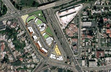
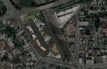
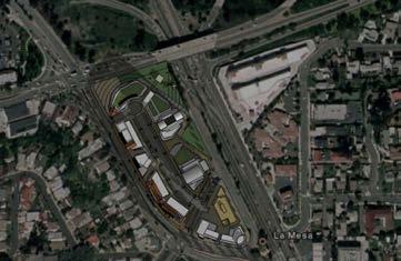
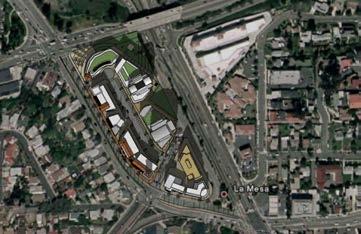

125 SUMMER 7:30 AM SUMMER 12:00 noon SUMMER 17:30 pm SUMMER Z:\Projects\j639301\MAPDOC\MAPS\EIR\Section 4 WINTER 8:30 AM WINTER 12:00 noon WINTER 15:30 pm 6393 SOURCE: CARRIERJOHNSON + CULTURE 2013 Park Station at the Crossroads of La Mesa Specific Plan - Environmental Impact Report WINTER FIGURE Proposed Project Shading Summer and Winter
City of Del Mar. Del Mar Resort Specific Plan Environmental Impact Report Notice of Preparation
 City of Del Mar Del Mar Resort Specific Plan Environmental Impact Report Notice of Preparation Date: September 9, 07 To: From: Subject: State Clearinghouse, Responsible Agencies, Trustee Agencies, Interested
Notice of Preparation of an Environmental Impact Report and Scoping Meeting for the Canyon Lane Roadway Improvements Development Project
 of an Environmental Impact Report and Scoping Meeting for the As the Lead Agency, the County of San Mateo (County) will prepare an Environmental Impact Report (EIR) for the (project), and would like your
Gold Line Bus Rapid Transit Transit Oriented Development (BRTOD) Helmo Station Area Plan
 Helmo Station Area Plan") Appendix F Gold Line Bus Rapid Transit Transit Oriented Development (BRTOD) Helmo Station Area Plan Introduction and Purpose of the Plan The Gold Line Bus Rapid Transit facility is an eleven-mile dedicated
Appendix F Gold Line Bus Rapid Transit Transit Oriented Development (BRTOD) Helmo Station Area Plan Introduction and Purpose of the Plan The Gold Line Bus Rapid Transit facility is an eleven-mile dedicated
PLANNED DEVELOPMENT (MASTER PLAN & UNIT PLAN)
") Central Permit Center 555 Santa Clara Street Vallejo CA 94590 Business License Building Fire Prevention Planning Public Works 707.648.4310 707.648.4374 707.648.4565 707.648.4326 707.651.7151 PLANNED DEVELOPMENT
Central Permit Center 555 Santa Clara Street Vallejo CA 94590 Business License Building Fire Prevention Planning Public Works 707.648.4310 707.648.4374 707.648.4565 707.648.4326 707.651.7151 PLANNED DEVELOPMENT
CITY OF CYPRESS 5275 Orange Avenue Cypress, California (714) DESIGN REVIEW COMMITTEE PERMIT PROCESS
 DESIGN REVIEW COMMITTEE PERMIT PROCESS") CITY OF CYPRESS 5275 Orange Avenue Cypress, California 90630 (714) 229-6720 DESIGN REVIEW COMMITTEE PERMIT PROCESS 1. Discuss project with Planning staff to determine zoning regulations, any unusual characteristics
CITY OF CYPRESS 5275 Orange Avenue Cypress, California 90630 (714) 229-6720 DESIGN REVIEW COMMITTEE PERMIT PROCESS 1. Discuss project with Planning staff to determine zoning regulations, any unusual characteristics
Venice Pumping Plant Dual Force Main Project Draft EIR
 City of Los Angeles 5.9 LAND USE PLANS 5.9.1 Environmental Setting Venice Pumping Plant Dual Force Main Project Draft EIR The Project lies within the bounds of Los Angeles County and the City of Los Angeles.
Planning Commission Staff Report June 5, 2008
 Owner/Applicant Taylor Village Sacramento Investments Partners, LP c/o Kim Whitney 1792 Tribute Road #270 Sacramento, CA 95815 Staff Recommendation Planning Commission Staff Report Project: File: Request:
GENERAL INFORMATIONaaaaaaaaaaaaaaaaaaaaaaaaaaaaaaaa
 To: Planning and Zoning Commission From: City Staff Date: November 15, 2016 Re: Case #16026 Raymore Activity Center Site Plan GENERAL INFORMATIONaaaaaaaaaaaaaaaaaaaaaaaaaaaaaaaa Applicant/ Property Owner:
COMMUNITY DEVELOPMENT SERVICES PLANNING AND BUILDING DEPARTMENT PLACERVILLE OFFICE:
 COMMUNITY DEVELOPMENT SERVICES PLANNING AND BUILDING DEPARTMENT http://www.edcgov.us/devservices/ PLACERVILLE OFFICE: LAKE TAHOE OFFICE: 2850 Fair Lane Court, Placerville, CA 95667 924 B Emerald Bay Rd.
Department of Community Development. Planning and Environmental Review Division Revised Notice of Preparation
 Department of Community Development Michael J. Penrose, Acting Director Divisions Building Permits & Inspection Code Enforcement County Engineering Economic Development & Marketing Planning & Environmental
3.10 LAND USE SETTING PROJECT SITE EXISTING LAND USE DESIGNATIONS AND ZONING. General Plan Land Use Designations.
 This section of the Draft EIR addresses the existing land uses on and adjacent to the project site and discusses the potential impacts of the proposed project on existing land uses. Key issues addressed
APPENDIX J PERFORMANCE STANDARDS FOR GRAVEL MINE, PIT MINE, OR QUARRY
 APPENDIX J PERFORMANCE STANDARDS FOR GRAVEL MINE, PIT MINE, OR QUARRY A. Purpose: 1. Regulatory Requirement and Use Mitigation: The purpose of this appendix is to provide a regulatory context (standards)
SAN FRANCISCO PLANNING DEPARTMENT
 PLANNING DEPARTMENT Certificate of Determination EXEMPTION FROM ENVIRONMENTAL REVIEW Case No.: Project Address: Zoning: UMU (Urban Mixed Use) Zoning District 68-X Height and Bulk District Life Science
4. ENVIRONMENTAL IMPACT ANALYSIS 7. LAND USE AND PLANNING
 4. ENVIRONMENTAL IMPACT ANALYSIS 7. LAND USE AND PLANNING 4.7.1 INTRODUCTION The following analysis discusses the consistency of the Proposed Project with the corresponding land use and zoning designations
Gadsden County Planning Commission Agenda Request
 Date of Meeting: November 16, 2017 To: From: Through: Subject: Gadsden County Planning Commission Agenda Request Honorable Chairperson and Members of the Board Jill A. Jeglie, AICP, Senior Planner Clyde
HEALTH SCIENCES BUILDING REDEVELOPMENT PROJECT
 INTRODUCTION In recent years, the University of Cincinnati (University) has demonstrated a commitment to identifying and implementing sustainable goals and objectives throughout University s Uptown Campuses.
AWH REPORT OF THE PLANNING AND DEVELOPMENT DEPARTMENT FOR APPLICATION FOR REZONING ORDINANCE TO PLANNED UNIT DEVELOPMENT
 AWH REPORT OF THE PLANNING AND DEVELOPMENT DEPARTMENT FOR APPLICATION FOR REZONING ORDINANCE TO PLANNED UNIT DEVELOPMENT MAY 8, 2014 The Planning and Development Department hereby forwards to the Planning
PG&E WINTERS GAS OPERATIONS AND TECHNICAL TRAINING CENTER
 PG&E WINTERS GAS OPERATIONS AND TECHNICAL TRAINING CENTER CEQA scoping Meeting March 19 th, 2014 Winters City Council Chambers - 6:30 pm AGENDA FOR THE MEETING 6:30 Welcome (John Donlevy) 6:40 Overview
SECTION 3.0 Project Description
 SECTION 3.0 3.0 PROJECT DESCRIPTION 3.1 PROJECT LOCATION AND SETTING PROJECT LOCATION The proposed Perris Downtown Specific Plan (DTSP) project (project) is located in the City of Perris, California. The
SUBJECT: PREDEVELOPMENT PLAN REVIEW OF PROJECT LOCATED AT E. COLORADO BOULEVARD (PASEO COLORADO)
") TO: FROM: Honorable Mayor and City Council Planning & Community Development Department SUBJECT: PREDEVELOPMENT PLAN REVIEW OF PROJECT LOCATED AT 260-400 E. COLORADO BOULEVARD (PASEO COLORADO) RECOMMENDATION:
TO: FROM: Honorable Mayor and City Council Planning & Community Development Department SUBJECT: PREDEVELOPMENT PLAN REVIEW OF PROJECT LOCATED AT 260-400 E. COLORADO BOULEVARD (PASEO COLORADO) RECOMMENDATION:
CHAPTER 2 SUMMARY 1. PROJECT SUMMARY DATA
 CHAPTER 2 SUMMARY This is an Initial Study format used to determine, pursuant to CEQA Guidelines Section 15177, whether a project 1) is within the scope of a Master EIR (MEIR), 2) may result in additional
Report to City Council
 Attachment 4 BUDGET OFFICER CITY ATTORNEY APPROVALS CITY MANAGER Report to City Council TO: FROM: Mayor and City Council John C. Terell, Community and Economic Development Director AGENDA DATE: June 24,
RESOLUTION NO. R Refining the route, profile and stations for the Downtown Redmond Link Extension
 RESOLUTION NO. R2018-32 Refining the route, profile and stations for the Downtown Redmond Link Extension MEETING: DATE: TYPE OF ACTION: STAFF CONTACT: Capital Committee Board PROPOSED ACTION 09/13/2018
DESIGN REVIEW COMMITTEE AGENDA ITEM
 DESIGN REVIEW COMMITTEE AGENDA ITEM AGENDA DATE: DECEMBER 16, 2015 TO: THRU: FROM: SUBJECT: Chair McCormick and Members of the Design Review Committee Leslie Aranda Roseberry, Planning Manager Kelly Christensen
3. Project Description
 3.1 PROJECT LOCATION The Platinum Triangle (herein after also referred to as the Project Area ) is located at the confluence of the Interstate 5 (I-5 Freeway) and the State Route 57 (SR-57 Freeway), in
ARTICLE VI: SITE PLAN REVIEW
 Section 6.01 - Site Plan Review (All Districts) ARTICLE VI: SITE PLAN REVIEW Site plans give the Planning commission an opportunity to review development proposals in a concise and consistent manner. The
PLANNING COMMISSION. Submitted
 PLANNING COMMISSION City Hall 1275 Main Street El Centro, CA 92243 Submitted PLANNING COMMISSION ACTION ITEM (1844) Meeting: 05/10/16 12:00 AM Department: Community Development Category: Public Hearing
PC RESOLUTION NO GRADING PLAN MODIFICATION (GPM)
") PC RESOLUTION NO. 16-07-26- GRADING PLAN MODIFICATION (GPM) 16-006 A RESOLUTION OF THE PLANNING COMMISSION OF THE CITY OF SAN JUAN CAPISTRANO, CALIFORNIA APPROVING GRADING PLAN MODIFICATION (GPM) 16-006,
PC RESOLUTION NO. 16-07-26- GRADING PLAN MODIFICATION (GPM) 16-006 A RESOLUTION OF THE PLANNING COMMISSION OF THE CITY OF SAN JUAN CAPISTRANO, CALIFORNIA APPROVING GRADING PLAN MODIFICATION (GPM) 16-006,
PC RESOLUTION NO ARCHITECTURAL CONTROL (AC)
") PC RESOLUTION NO. 16-07-26- ARCHITECTURAL CONTROL (AC) 15-035 A RESOLUTION OF THE PLANNING COMMISSION OF THE CITY OF SAN JUAN CAPISTRANO, CALIFORNIA APPROVING ARCHITECTURAL CONTROL (AC) 15-035, INN AT
PC RESOLUTION NO. 16-07-26- ARCHITECTURAL CONTROL (AC) 15-035 A RESOLUTION OF THE PLANNING COMMISSION OF THE CITY OF SAN JUAN CAPISTRANO, CALIFORNIA APPROVING ARCHITECTURAL CONTROL (AC) 15-035, INN AT
~P'~'~; SAN FRANCISCO
 ~o counr~, ~P'~'~; SAN FRANCISCO ~'.~ PLANNING DEPARTMENT a 2 757 O~~~S 0 Case No.: Project Address: Zoning: Certificate of Determination COMMUNITY PLAN EVALUATION UMU (Urban Mixed Use) District 58-X Height
TREASURE COAST REGIONAL PLANNING COUNCIL M E M O R A N D U M. To: Council Members AGENDA ITEM 5H
 TREASURE COAST REGIONAL PLANNING COUNCIL M E M O R A N D U M To: Council Members AGENDA ITEM 5H From: Date: Subject: Staff October 17, 2008 Council Meeting Local Government Comprehensive Plan Review Draft
DRAFT MAP AMENDMENT FLU 04-4
 DRAFT MAP AMENDMENT FLU 04-4 SW 24 TH AVENUE ROADWAY CORRIDOR The University of Florida participates with the Metropolitan Transportation Planning Organization (MTPO) in its responsibilities for the continuing,
The transportation system in a community is an
 7 TRANSPORTATION The transportation system in a community is an important factor contributing to the quality of life of the residents. Without a sound transportation system to bring both goods and patrons
M E M O R A N D U M. Chair and Members of North West Planning Advisory Committee
 Item 9.1.1 PO Box 1749 Halifax, Nova Scotia B3J 3A5 Canada M E M O R A N D U M TO: FROM: Chair and Members of North West Planning Advisory Committee Stephanie Salloum, Planner II DATE: June 26, 2017 SUBJECT:
City of Larkspur. Notice of Mitigated Negative Declaration for the 285
 Notice of Mitigated Negative Declaration for the 285 Magnolia Avenue Mixed-Use Project Date: December 2, 2013 Responsible Agency: Project Title: 285 Magnolia Avenue Mixed-Use Project Project Address: 285
Description of Preferred Alternative
 Chapter 2 Description of Preferred Alternative 2.1 Introduction This chapter of the programmatic Sammamish Town Center Sub-area Plan Final EIS provides a more detailed description of the Preferred Alternative
3.0 Project Description
 3.0 Project Description 3.0 PROJECT DESCRIPTION 3.1 PROJECT LOCATION AND SETTING PROJECT LOCATION The proposed Downtown Lancaster Specific Plan Project (project) is located in the City of Lancaster, California.
CHAPTER 1. Ms. Guajardo s Class - Central Elementary CH 1 1
 INTRODUCTION CHAPTER 1 Ms. Guajardo s Class - Central Elementary CH 1 1 1.1 SETTING South Centre City is a linear corridor south of Downtown Escondido paralleling Centre City Parkway and South Escondido
12 January 12, 2011 Public Hearing APPLICANT: TAILWIND DEVELOPMENT GROUP,LLC PROPERTY OWNER: CITY OF VIRGINIA BEACH
 12 January 12, 2011 Public Hearing APPLICANT: TAILWIND DEVELOPMENT GROUP,LLC PROPERTY OWNER: CITY OF VIRGINIA BEACH STAFF PLANNER: Faith Christie REQUEST: Conditional Change of Zoning (from PD-H1 Planned
PINE CURVE REZONING. BACKGROUND Purchased as two parcels in 2001 and 2002
 BACKGROUND Purchased as two parcels in 2001 and 2002 WHAT THE PROJECT IS AND IS NOT A Rezoning establishes the land use standards for Annexed and Zoned Greater Downtown District Historic Center September
CITY OF MANHATTAN BEACH DEPARTMENT OF COMMUNITY DEVELOPMENT. TO: Parking and Public Improvements Commission
 Clay Curtin, Management Analyst (I the same walls at a maximum of 1 foot tall. Section 7.36.150 of the Municipal Code permits BY: Eric Haaland, Associate Planner right-of-way) between walkways leading
Construction and Landscaping on Public Property
 Construction and Landscaping on Public Property City of Manhattan Beach Community Development Department 1400 Highland Avenue 310-802-5504 www.citymb.info January, 2004 Construction and Landscaping on
A. WHAT IS A GENERAL PLAN?
 I. Introduction A. WHAT IS A GENERAL PLAN? A general plan is the planning guideline for the future of a city. It contains goals and policies which regulate urban development, the protection of the natural
Table of Contents G.1.a Water Resources - Surface Water - Drainage
 Table of Contents G.1.a Water Resources - Surface Water - Drainage 1. INTRODUCTION... 1335 2. ENVIRONMENTAL SETTING... 1335 a. Regional Hydrology... 1335 b. Local Hydrology... 1337 c. On-site Hydrology...
PRELIMINARY CONDITIONAL USE SUBMITTAL CHECKLIST REQUIREMENTS
 This checklist must accompany your submittal as the cover page. CONDITIONAL USE Application Submittal Checklist for PRELIMINARY AND FINAL APPROVAL Per Winter Park Land Development Code Sec. 58-90 PRELIMINARY
2.7 ac park. TOTAL 5,403 DU 1,297,900 sf 1,105,450 sf 3.87 ac 5,563 DU 1,121,200 sf 1,105,450 sf 3.87 ac
 PLAN AMENDMENT 2013-I-B1: SEVEN CORNERS SPECIAL STUDY Summary of Pre-staffing Comments Planner: Bernard Suchicital bsuchi@fairfaxcounty.gov (703) 324-1254 Background On October 29, 2013, the Board of Supervisors
FRUITVALE TRANSIT VILLAGE (Phase 2) Residential Project
 Residential Project") FRUITVALE TRANSIT VILLAGE (Phase 2) Residential Project DEVELOPER: SIGNATURE PROPERTIES ARCHITECT: HKIT ARCHITECTS April 23, 2010 TABLE OF CONTENTS 3 Vision 4 Description of Site 5 Guiding Concepts 6
FRUITVALE TRANSIT VILLAGE (Phase 2) Residential Project DEVELOPER: SIGNATURE PROPERTIES ARCHITECT: HKIT ARCHITECTS April 23, 2010 TABLE OF CONTENTS 3 Vision 4 Description of Site 5 Guiding Concepts 6
NOTICE OF AVAILABILITY (NOA) OF A DRAFT ENVIRONMENTAL IMPACT REPORT AND NOTICE OF PUBLIC HEARING 2190 Shattuck Avenue Mixed-Use Project
 OF A DRAFT ENVIRONMENTAL IMPACT REPORT AND NOTICE OF PUBLIC HEARING 2190 Shattuck Avenue Mixed-Use Project") Planning and Development Department Land Use Planning Division NOTICE OF AVAILABILITY (NOA) OF A DRAFT ENVIRONMENTAL IMPACT REPORT AND NOTICE OF PUBLIC HEARING 2190 Shattuck Avenue Mixed-Use Project Notice
Planning and Development Department Land Use Planning Division NOTICE OF AVAILABILITY (NOA) OF A DRAFT ENVIRONMENTAL IMPACT REPORT AND NOTICE OF PUBLIC HEARING 2190 Shattuck Avenue Mixed-Use Project Notice
3.0 PROJECT DESCRIPTION
 3.0 PROJECT DESCRIPTION 3.1 BACKGROUND Under California law (Government Code Section 65300 et seq.), every city and county is required to have a general plan. The general plan is to be comprehensive and
Staff Report. Conditional Use PLANNING DIVISION COMMUNITY & ECONOMIC DEVELOPMENT. Salt Lake City Planning Commission
 Staff Report PLANNING DIVISION COMMUNITY & ECONOMIC DEVELOPMENT To: From: Salt Lake City Planning Commission Maryann Pickering, Principal Planner (801) 535-7660 Date: December 10, 2014 Re: Church of Scientology
EXISTING COMPREHENSIVE PLAN
 EXISTING COMPREHENSIVE PLAN Town Center Land Use Element: V. LAND USE POLICIES Town Center Mercer Island's business district vision as described in "Your Mercer Island Citizen-Designed Downtown" was an
NOTICE OF PREPARATION
 NOTICE OF PREPARATION DATE: January 6, 2016 TO: LEAD AGENCY: Responsible Agencies, Organizations, and Interested Parties Contact: Tyler Barrington, Principal Planner Planning Department Community Development
REQUEST Current Zoning: O-15(CD) (office) Proposed Zoning: TOD-M(CD) (transit oriented development mixed-use, conditional)
 (office) Proposed Zoning: TOD-M(CD) (transit oriented development mixed-use, conditional)") Rezoning Petition 2016-117 Zoning Committee Recommendation January 4, 2017 REQUEST Current Zoning: O-15(CD) (office) Proposed Zoning: TOD-M(CD) (transit oriented development mixed-use, conditional) LOCATION
Rezoning Petition 2016-117 Zoning Committee Recommendation January 4, 2017 REQUEST Current Zoning: O-15(CD) (office) Proposed Zoning: TOD-M(CD) (transit oriented development mixed-use, conditional) LOCATION
Baumgarten MPUD. Exhibit 3 Evaluation Criteria
 Pursuant to LDC subsections 10.02.13 B, 10.02.08 F and Chapter 3 G. of the Administrative Code, staff s analysis and recommendation to the Planning Commission, and the Planning Commission s recommendation
4 January 11, 2012 Public Hearing APPLICANT:
 . 4 January 11, 2012 Public Hearing APPLICANT: MID-ATLANTIC AUTO PROPERTY OWNER: DZR, LLC STAFF PLANNER: Leslie Bonilla REQUEST: Conditional Use Permit (truck rental, automobile service, and automotive/bulk
City Council Special Meeting AGENDA ITEM NO. C.
 City Council Special Meeting AGENDA ITEM NO. C. DATE: 01/04/2019 TO: Honorable Mayor and City Council Members SUBJECT: Transit Villages Specific Plan project Study Session (Development Services Director
OCEAN BOULEVARD PLANNED DEVELOPMENT DISTRICT (PD-5)
") OCEAN BOULEVARD PLANNED DEVELOPMENT DISTRICT (PD-5) Ordinance History: C-5562, 1982 The intent of the Planned Development Plan is to provide a framework to guide new development in a way that is sensitive
OCEAN BOULEVARD PLANNED DEVELOPMENT DISTRICT (PD-5) Ordinance History: C-5562, 1982 The intent of the Planned Development Plan is to provide a framework to guide new development in a way that is sensitive
3. Are there any projects exempt from the definition of Regulated Projects?
 STORMWATER REQUIREMENTS: OVERVIEW OF PROVISION C.3 Background: On October 14, 2009, the Regional Water Quality Control Board, San Francisco Bay Region, issued a municipal regional stormwater permit (MRP)
PART 1: PROJECT SUMMARY. The application is Attachment A. The site plan is Attachment B.
 Belleterre Subdivision Sketch Plan Town Board 8.7.17 Belleterre Subdivision Sketch Plan PART 1: PROJECT SUMMARY Applicant: Bowman Development Project Size: +/- 20.85 acres Parcel Number: 01115104 and 01115121
3. VISION AND GOALS. Vision Statement. Goals, Objectives and Policies
 Vision Statement Queen Creek s interconnected network of parks, trails, open spaces and recreation opportunities provide safe and diverse activities and programs that sustain its unique, small town, equestrian
PLANNED UNIT DEVELOPMENT & SUBDIVISION STAFF REPORT Date: May 18, 2017
 & PUD-0000102-2017 PLANNED UNIT DEVELOPMENT & SUBDIVISION STAFF REPORT Date: May 18, 2017 NAME SUBDIVISION NAME Dauphin Creek Estates Subdivision Dauphin Creek Estates Subdivision LOCATION CITY COUNCIL
3.1 community vision. 3.3 required plan elements
 Chapter 3 Community Form 3.1 community vision 3.2 Parks & landscaping concepts 3.3 required plan elements D R A F T 20 Community Form Chapter 3 3.0 Community form 3.1 community vision The Specific Plan
Chapter Master Planned Communities (MPC) District
 District") Sections 14.53.010 Purpose and Intent 14.53.020 Applicability 14.53.030 Procedure 14.53.040 MPC Standards 14.53.050 Required Findings 14.53.010 Purpose and Intent Chapter 14.53 Master Planned Communities
Sections 14.53.010 Purpose and Intent 14.53.020 Applicability 14.53.030 Procedure 14.53.040 MPC Standards 14.53.050 Required Findings 14.53.010 Purpose and Intent Chapter 14.53 Master Planned Communities
COMMUNITY DESIGN. GOAL: Create livable and attractive communities. Intent
 COMMUNITY DESIGN Intent An attractive, well-designed County will attract quality development, instill civic pride, improve the visual character of the community, and create a strong, positive image for
ARTICLE IX SPECIAL PERMIT USES
 ARTICLE IX SPECIAL PERMIT USES All special permit uses cited in Article IX and Attachment A of this Ordinance or any other Section of this Ordinance shall be subject to Site Plan Review. The procedures
D1 September 11, 2013 Public Hearing APPLICANT:
 D1 September 11, 2013 Public Hearing APPLICANT: BEACH MUNICIPAL FEDERAL CREDIT UNION PROPERTY OWNER: SISTERS II, LLC STAFF PLANNER: Karen Prochilo REQUEST: Conditional Change of Zoning (AG-2 Agriculture
III. PROJECT DESCRIPTION
 III. PROJECT DESCRIPTION LOCATION AND BOUNDARIES The City of Manhattan Beach is located in the South Bay region of Los Angeles County, California, approximately 2 miles south of the Los Angeles International
Glenborough at Easton Land Use Master Plan
 Implementation 114 9.0 IMPLEMENTATION 9.1 OVERVIEW This chapter summarizes the administrative procedures necessary to implement the proposed land use plan, infrastructure improvements, development standards,
SECTION 2.0 INTRODUCTION
 SECTION 2.0 INTRODUCTION 2.1 PURPOSE AND SCOPE OF THE EIR Environmental Impact Reports (EIR) are informational documents which wil inform public agency decision-makers and the public generally of the significant
Town of Portola Valley General Plan. Nathhorst Triangle Area Plan
 Town of Portola Valley General Plan Amended December 10, 1997 Table of Contents Introduction... 1 Planning Area... 1 Objectives... 2 Principles... 2 Standards... 4 Description... 4 Community Commercial...
4.1.3 LAND USE CATEGORIES
 4.1.3 LAND USE CATEGORIES a. City Center District The City Center District incorporates the existing character and mix of uses in downtown Belmont to encourage redevelopment and new development in keeping
Mitchell Ranch South MPUD Application for Master Planned Unit Development Approval Project Narrative. Introduction
 Mitchell Ranch South MPUD Application for Master Planned Unit Development Approval Project Narrative Introduction Mitchell Ranch South is a proposed single family (detached) residential development on
Staff Report CONDITIONAL USE
 Staff Report PLANNING DIVISION COMMUNITY & ECONOMIC DEVELOPMENT To: From: Salt Lake City Planning Commission Daniel Echeverria, (801) 535-7165, daniel.echeverria@slcgov.com Date: May 21, 2015 Re: PLNPCM2015-00139
PLANNING COMMISSION AGENDA REPORT APRIL 7, 2016
 PLANNING COMMISSION AGENDA REPORT APRIL 7, 2016 TO: FROM: Members of the Planning Commission Talyn Mirzakhanian, Senior Planner FILE NO.: 160001710 PROPOSAL: APPLICANT: RECOMMENDATION: A request for a
City of Yelm. Tahoma Terra Final Master Plan Development Guidelines. Table of Contents
 City of Yelm Tahoma Terra Final Master Plan Development Guidelines Table of Contents Table of Contents... 1 Purpose... 2 Low Density Residential (R4-6)... 3 Moderate Density Residential (R6-10)... 5 Neighborhood
Ephrata Municipal Code, Chapter 19.07, Landscaping Regulations DRAFT January 28, 2013 Page 1
 Chapter 19.07 LANDSCAPING REGULATIONS Sections: 19.07.010 Purpose. 19.07.020 Landscape plan approval. 19.07.030 Failure to complete required landscaping Inspection. 19.07.040 General landscape requirements
CITY OF ALAMEDA PLANNING BOARD Draft RESOLUTION
 CITY OF ALAMEDA PLANNING BOARD Draft RESOLUTION A RESOLUTION OF THE PLANNING BOARD OF THE CITY OF ALAMEDA APPROVING DESIGN REVIEW AND DEVELOPMENT PLAN AMENDMENT APPLICATION PLN13-0157 TO CONSTRUCT ELEVEN
EXHIBIT B PROJECT NARRATIVE POULSBO MEADOWS
 EXHIBIT B PROJECT NARRATIVE POULSBO MEADOWS Name of Project: Poulsbo Meadows; A Planned Residential Development (PRD)/Plat Applicants Name: PBH Group LLC/Byron Harris PO Box 1010 Silverdale, WA 98038 Description
Sanford/Lee County Technical Review Committee (TRC) DEADLINES & MEETING DATES
 DEADLINES & MEETING DATES") Sanford/Lee County Technical Review Committee (TRC) DEADLINES & MEETING DATES The following 2019 information is based on the information available to staff at the time of creation. Dates & time may change
Sanford/Lee County Technical Review Committee (TRC) DEADLINES & MEETING DATES The following 2019 information is based on the information available to staff at the time of creation. Dates & time may change
Major Subdivision Sketch Plan Checklist
 This checklist provides specific requirements that are apart of the Sketch process. The entire process is described by the Huntersville Subdivision Review Process which details all the submittal and resubmittal
Notice of Preparation
 Notice of Preparation OF ENVIRONMENTAL IMPACT REPORT AND PUBLIC SCOPING MEETING August 7, 2017 CASE NO.: ENV-2016-3631-EIR PROJECT NAME: 6400 Sunset Boulevard Project PROJECT APPLICANT: 6400 Sunset, LLC
SECTION UNIFIED DEVELOPMENT ORDINANCE SECTION Part 1 Ordinance. ARTICLE 1 Zoning Districts
 SECTION 1-100 UNIFIED DEVELOPMENT ORDINANCE SECTION 1-300 Part 1 Ordinance SECTION 1-100. Introduction. ARTICLE 1 Zoning Districts Crystal Lake strives to maintain a balance of various land uses for a
Chesapeake Bay Critical Area Conservation Plan
 The Maryland-National Capital Park and Planning Commission Prince George s County Planning Department Development Review Division 301-952-3530 Note: Staff reports can be accessed at www.mncppc.org/pgco/planning/plan.htm.
Project Applicant Checklist for NPDES Permit Requirements SAN MATEO COUNTYWIDE STORMWATER POLLUTION PREVENTION PROGRAM
 Project Applicant Checklist for NPDES Permit Requirements SAN MATEO COUNTYWIDE STORMWATER POLLUTION PREVENTION PROGRAM I. PROJECT DATA Project Name Bay Meadows Development Phase II Project Address 2600
PINE CURVE REZONING. Property does not meet criteria for open space preservation and is not a candidate for a park
 PINE CURVE REZONING BACKGROUND Purchased as two parcels in 2001 and 2002 Annexed and Zoned Greater Downtown District Historic Center September 25, 2002 and October 7, 2002 WHAT THE PROJECT IS AND IS NOT
Planned Development Review Revisions (Project No. PLNPCM )
") Planned Development Review Revisions (Project No. PLNPCM2014-00139) Standard residential development Planned Development Example: Smaller lot sizes than what is allowed to create open space amenity. What
Planned Development Review Revisions (Project No. PLNPCM2014-00139) Standard residential development Planned Development Example: Smaller lot sizes than what is allowed to create open space amenity. What
City Center Specific Plan Amendments And Background Report City of Richmond. PLANNING COMMISION FINAL DRAFT January, 2001
 City Center Specific Plan Amendments And Background Report City of Richmond PLANNING COMMISION FINAL DRAFT January, 2001 TABLE OF CONTENTS Page LIST OF TABLES... LIST OF FIGURES... INDEX... OVERVIEW...
Clay Street Bridge Replacement Project
 Clay Street Bridge Replacement Project Frequently Asked Questions (FAQs) No. 2 April 4, 2018 The project is located in downtown Placerville on Clay Street between US Highway 50 and Main Street and Cedar
Future Five. Design/ Development Guidelines. January 2008 Amended June 08 per City Council motion
 Future Five Design/ Development Guidelines January 2008 Amended June 08 per City Council motion 5-Points Design Guidelines Table of Contents I. Introduction 3 II. Area boundaries 4 III. Review Process
Narcoossee Roadway Corridor
 Community Meeting Narcoossee Roadway Corridor April 5, 2012 Meeting Agenda Purpose of Meeting Continuation of Study Update Process (Previous Meetings Oct. & Nov., 2011) Tonight s Objective Review Proposals
LOS ANGELES CITY PLANNING DEPARTMENT STAFF REPORT
 LOS ANGELES CITY PLANNING DEPARTMENT STAFF REPORT LOS ANGELES CITY PLANNING COMMISSION CASE NO: CPC 2006-9374 CRA CEQA: Exempt DATE: December 21, 2006 Location: Valley Plaza and Laurel Plaza TIME: after
ATTACHMENT A. SILVERDALE DESIGN STANDARDS Amendments to the Waaga Way Town Center Chapter
 ATTACHMENT A SILVERDALE DESIGN STANDARDS Amendments to the Waaga Way Town Center Chapter Chapter 10. Waaga Way Town Center 10.1 Physical Identity Elements & Opportunities The Waaga Way Town Center includes
D3 January 14, 2015 Public Hearing
 D3 January 14, 2015 Public Hearing APPLICANT: DONALD J. BOUCHER, JR. PROPERTY OWNER: D.J.B. SERVICE CENTER, LLC STAFF PLANNER: Kristine Gay REQUEST: A. Conditional Change of Zoning (I-1 to B-2) B. Conditional
3.0 URBAN DESIGN. December 6, OVERVIEW
 Urban Design 3.0 URBAN DESIGN December 6, 2007 3.1 OVERVIEW The highly urban character of Easton Place is defined by the overall design of the community. The following sections provide an overview of the
SAN FRANCISCO. x ~ OT`s 0~5` PLANNING DEPARTMENT. Certificate of Determination COMMUNITY PLAN EVALUATION PROJECT DESCRIPTION CEQA DETERMNATION
 y;~~~ counr~on u "'s' 9z x ~ OT`s 0~5` SAN FRANCISCO PLANNING DEPARTMENT COMMUNITY PLAN EVALUATION Case No.: Project Address: Zoning: RTO-M (Residential Transit Oriented-Mission) Use District Calle 24
RRW Stonebrook, LLC Tentative Map Findings
 RRW Stonebrook, LLC Tentative Map Findings FINDING T1: The request conforms to the Master Plan and zoning ordinances. RELATIONSHIP TO THE MASTER PLAN 1. The respective development is located within an
DENVER DESIGN DISTRICT GDP
 DENVER DESIGN DISTRICT GDP Urban Design Standards and Guidelines November 17, 2008 Amended February 3, 2016 City and County of Denver CF Property Management, Inc. C/O Denver Design District - Starboard
Notice of Preparation
 Notice of Preparation OF ENVIRONMENTAL IMPACT REPORT AND PUBLIC SCOPING MEETING August 23, 2017 REVISED AND RECIRCULATED NOTICE OF PREPARATION OF AN ENVIRONMENTAL IMPACT REPORT AND SCOPING MEETING Note:
MONTGOMERY COUNTY PLANNING DEPARTMENT THE MARYLAND-NATIONAL CAPITAL PARK AND PLANNING COMMISSION
 MONTGOMERY COUNTY PLANNING DEPARTMENT THE MARYLAND-NATIONAL CAPITAL PARK AND PLANNING COMMISSION MCPB Item No. Date: 3.10.2016 Site Plan 820160040 Nora School Parker Smith, Planning Technician, Area 1,
ORDINANCE NO. City of Bellingham City Attorney 210 Lottie Street Bellingham, Washington INFILL HOUSING ORDINANCE Page 1
 ORDINANCE NO. AN ORDINANCE RELATING TO LAND USE PLANNING AND ZONING, CREATING A NEW BMC CHAPTER 20.28 INFILL HOUSING, AND NEW SUBSECTION BMC 20.12.030.E, GREEN FACTOR LANDSCAPING STANDARDS, AND AMENDING