development framework
|
|
|
- Emil Webster
- 5 years ago
- Views:
Transcription
1 dublin city council: heuston gateway regeneration strategy substudy document: guinness udv lands Guinness UDV Lands development framework
2 Dublin City Council Steering Group: Sean Carey Ast. City manager Jim Barrett City Architect Dick Gleeson Deputy Planning Officer Alan Taylor Economic Development Officer Mary Conway Senior Planner Consultant Team: Urban Projects: Derek Tynan Michael McGarry Gerry Cahill Philip Crowe Urban Design / Project Management Louise McGuinness Dirk Frey Michael Bassett Markus Lassan DTZ Sherry Fitzgerald: Peter Waller Fergal McCabe Fergal McCabe Rachel Brennan Faber Maunsell Cormac O Brien Joe Seymour Ian McNamara Michael Bassett Markus Lassan Philip Crowe Property Advisors Strategic Planning Transport and Infrastructure Graphics Photography Issued to Dublin City Council, May 2003 introduction

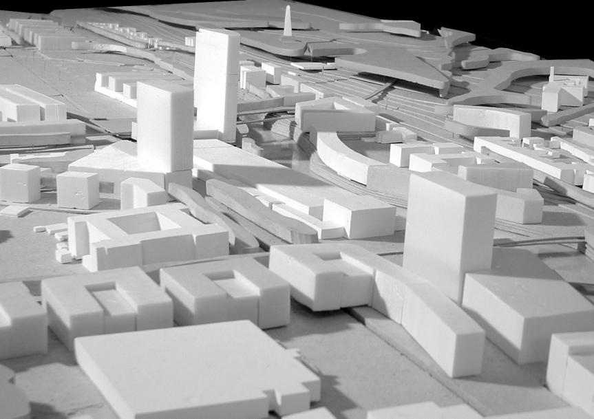
3 1.0 Introduction This document describes the Development Framework Proposal for lands owned by Guinness UDV fronting onto Steevens Lane and Victoria Quay. The Development Framework Plan is part of a wider study: The Heuston Gateway Regeneration Strategy and Development Framework Plan. The proposal therefore is in line with the development framework plan for the wider area, as described in Part 2: Regeneration Strategy and Development Framework Plan. heuston gateway boundary guinness udv lands boundary 1.1 Site Location The lands referred to in this document as the Guinness UDV lands are a zone on the Northern and Western sides of the Guinness UDV lands between the river and St. James Gate. Please refer to plan opposite. Guinness UDV Lands: Overall Guinness UDV area (hectares): Site area (hectares): Gross development capacity (sq.m): Plot Ratio overall Guinness UDV area: 1.1 Site area: 4.2 Present zoning: Z3 / Z4 / Z7 Proposed zoning: Z3 / Z4 / Z5 / Z6 / Z7 guinness udv lands location plan introduction

4 1.2 Site Description The Guinness site is key to the development of the overall Heuston Gateway due to its large area and location. Development is subject to Guinness UDV s operational requirements and has been restricted to the three sites along the periphery of the Guinness lands north of St. James Gate described below: Site C: Victoria Quay is presently characterised by a wide busy road and the blank wall and vehicular entrance of the Guinness lands. Victoria Quay is one of the most hostile environments in the area. However the site has huge potential due to the: Site A: the zone along Steevens Lane in the location of the old Caskworks Site B : corner site with frontage onto Heuston Square and Victoria Quay Site C : lands onto Victoria Quay - Length of river frontage and potential to continue the built form of the quays. - Proximity to Heuston Station, Phoenix Park, city centre and national institutions. - Views over to the Collins Barracks to the north and along the Liffey corridor. - Prominent position at the gateway to the city centre. site A Site A: The Caskworks site along Steevens Lane is presently characterised by underused or abandoned buildings. Steevens Lane will soon be solely for use by Luas, pedestrians, cyclists and access only traffic. The site is tucked away from the main public arena at Heuston but has the following potentialities: Proximity to Heuston Station, Phoenix Park, city centre and national institutions Frontage onto quality pedestrian and public transport environment Position opposite the principal façade of an architecturally and historically significant building Dr Steevens Hospital. Location within the Guinness lands which has a precedent for high buildings and no restrictive historical urban grain a suitable location for high density mixed use development. Possible connection to existing road within Guinness lands running from Thomas Street to Victoria Quay. site s A-C location plan site B site C Site B: Site B is at the corner of the Guinness lands opposite Heuston Station. The potentialities of the site are similar to site C. Site B has greater prominence due to aspect onto the river, Heuston Square and Station. site A site B site C introduction
5

6 2.0 Development Framework Plan The Development Framework Plan proposes the following development onthe Guinness UDV lands Site A: Development on this site should be principally commercial. While residential uses would be preferable in terms of mix of use throughout the area, it is considered impractical in light of the necessity to preserve the manufacturing processes currently carried out on the Guinness lands. The hours of work and noise levels on the Guinness lands is considered unsuitable for adjacent residential development as there might be a risk of injunctions being made against Guinness. If however the nature of work and processes on the Guinness lands change, residential should be considered. 6 storey commercial development in a series of four blocks allowing light and views to and from the Guinness lands is proposed. The northern block must address Dr. Steevens Hospital Park and Heuston Square. This block has a high profile landmark location and should be of the highest architectural standards. This block also provides frontage onto the new westbound access road. The building line should be set back and the development should address the public space of Steevens Lane. The space must be re-designed to provide clear demarcation between Luas lines, vehicular carriageways, cycle-tracks and footpaths (please refer to section 3.3.6). guinness udv lands development plan location Site B: Site B should be the location for a distinctive landmark building with a commercial/ cultural use. The development is to be generally six storeys. The development should address Heuston Square and Victoria Quay. Principal entry should be from the Heuston Square. Part of the Heuston Square site should be the location for a tall structure of appropriate slenderness. The tall structure must address Heuston Square at street level. overall development plan landmark buildings Site B: Potsdamer Platz, Berlin [Renzo Piano] GSW Headquarters, Berlin [Sauerbruch Hutton Architects office development Site A Research Headquarters, Basel [Herzog and De Meuron] S3 Offices, Dublin [FKL Architects] University building, Utrecht [Mecanoo] Commercial building, Munich [Herzog and De Meuron] development framework plan

7 Guinness Lands Development Plan development framework plan


8 Site C: The more open context of this presently under-developed land justifies an increase in building height. This height should be restricted to allow the profile of the higher Guinness structures near St. James s Gate to be viewed from the north city. A visual impact assessment of any proposed development should be carried out as necessary. Site C should be commercial development of up to six storeys. The buildings will have a hi-profile frontage onto Victoria Quay and accordingly must be of the highest architectural design standard. Development along Victoria Quay should be broken at regular intervals to allow south light onto the Quays and views to and from the Guinness lands. The building line onto Victoria Quay should be adjusted to accommodate generous pedestrian/ cycle amenity. The development should appropriately accommodate 2 listed structures: the original Guinness Gate Lodge and the pub on the corner of Watling Street (please refer to section 4.1.4). The development should allow for the required access between Victoria Quay and the Guinness lands. The development should provide for a new road branching off at Victoria Quay to be in line with St. John s Road as indicated. Pedestrian access to the rear of the new development on Victoria Quay between Watling Street and Heuston Square would provide a direct link between the station and the Digital Hub. public spaces heuston square victoria quay stevens lane dr. steevens park model view commercial development Site C Potsdamer Platz, Berlin [masterplan: Renzo Piano] public domain development framework plan
 and Victoria Quay (site C) with a high profile landmark building on the")

9 3.0 Zoning The zoning objective for the Guinness lands must ensure that no development can occur that might restrict in any way the present or future use of the Guinness UDV Brewery. The Development Framework Plan for the Heuston Gateway proposes development of commercial uses along Steevens Lane (site A) and Victoria Quay (site C) with a high profile landmark building on the corner site (site B). The present Z7 zoning objectives for the Guinness lands are to provide for the protection and creation of industrial uses and facilitate opportunities for employment creation. Office use, the predominant proposed future use, is not within the permitted or open for consideration categories of the present Development Plan. It will therefore be necessary to vary the Development Plan, make a Local Area Plan or await the review of the Development Plan. Offices for the exclusive use of Guinness UDV would be permissible under the present zoning as this can be seen as part of the existing industrial use. The revised zoning in the new Development Plan should state that the Guinness UDV Brewery and all associated activites including production, storage, marketing, distribution and administration, undertaken principally within the James s Street, Watling Street, Victoria Quay, Steeven s Lane precinct, are of major importance to the city, in terms of employment as well as industrial and cultural heritage. The new Development Plan should also state that it is a specific objective of Dublin City Council to ensure the continued operation Guinness UDV industrial activities on these lands and to facilitate their consolidation and expansion as appropriate. Notwithstanding the zoning objective for these lands therefore, any development proposals which would adversely impact on the safe and proper continuation of Guinness UDV operations, will not be permitted. It is proposed to designate the majority of the development site to Z6: to provide for the creation and protection of enterprise and facilitate opportunities for employment creation. The corner site should be designated Z5: to consolidate and facilitate the development of the central area, and to identify, reinforce, strengthen and protect its civic design character and dignity. This should ensure development of the highest standards on the corner site and create a compatible buffer with the Guinness UDV Brewery along Steevens Lane and Victoria Quay. Dublin Development Plan Dublin Development Plan, proposed rezoning zoning
4.00 STAKEHOLDERS. urbanprojects
 4.00 STAKEHOLDERS 94 heuston gateway: regeneration strategy and development framework plan 95 The Heuston Gateway presents one of the greatest concentrations of brown field development sites located adjacent
development framework
 dublin city council: heuston gateway regeneration strategy substudy document: cie lands CIE Lands development framework Dublin City Council Steering Group: Sean Carey Ast. City manager Jim Barrett City
HEUSTON GATEWAY PART 2: REGENERATION STRATEGY AND DEVELOPMENT FRAMEWORK PLAN
 HEUSTON GATEWAY PART 2: REGENERATION STRATEGY AND DEVELOPMENT FRAMEWORK PLAN Urban Projects for Dublin City Council Contents: 1.0 INTRODUCTION 1.1 background 1.2 the aim of this document 1.3 structure
public spaces and associated development
 4.0 Public Spaces and Associated Development The Guinness lands are adjacent to 3 of the principal public spaces of the Development Framework Plan for the Heuston Gateway as described below. 4.1 Heuston
heuston gateway: summary report
 Significant View: Royal Hospital Kilmainham to Phoenix Park. hoenix Park to Royal Hospital: view of Royal Hospital from Phoenix Park to Wellington Monument view of Royal Hospital rail bridge from Conyngham
heuston gateway: sections heuston gateway: regeneration strategy and development framework plan
 B B1 A B1 B C A heuston gateway: sections B B1 C 117 4.3.3 Zoning The station is the central hub of the area and this function must be preserved and developed. However large areas of the Heuston Station
public spaces and accociated development
 4.0 Public Spaces and Associated Development The development must address appropriately the public spaces immediately adjoining it: the River Walkway and Parkgate Street. The development is also highly
3.1.1 Heuston Square. heuston gateway: regeneration strategy and development framework plan. Heuston Gateway: public domain: Heuston Square location
 3.1.1 Heuston Square The space to the front of the Headquarters Building of the Great Western Railway is considered to be in the centre of the Heuston Gateway. All destinations in the area radiate from
development framework plan
 3.2.1.1 Phoenix Park to Royal Hospital Kilmainham The Phoenix Park and Royal Hospital Kilmainham Park have been separated since the construction of the Heuston Station in the mid 1800s. Consequently both
stakeholders Zoning Conservation Connections
 4.7.1 Zoning The Phoenix Park site is identified as an important gateway site to the city. The site should be developed as a landmark public building with office or cultural use. The present zoning, Z9,
public spaces and associated development
 4.1 West Terrace (1) A new public space, the West Terrace, is proposed to the west of station, elevated over tracks. The West Terrace is part of a sequence of spaces running from IMMA to the Phoenix Park,
Keystone Business Park Precinct Structure Plan North East Industrial Precinct. Part 2 Design Principles
 Keystone Business Park Precinct Structure Plan North East Industrial Precinct Part 2 Design Principles Context Issues Services Landform Issues Geotech and contamination Ecology Traffic and access Issues
Chapter 2: OUTLINE PLANNING APPLICATION PROPOSALS. A New Garden Neighbourhood Matford Barton 17
 Chapter 2: OUTLINE PLANNING APPLICATION PROPOSALS A New Garden Neighbourhood Matford Barton 17 2.1. SUMMARY AND STATUS OF THE PROPOSALS 2.1.1. The parameter plans and associated wording in this chapter
3.0 Area-Wide Strategies 30
 3.0 Area-Wide Strategies 30 3.6 Tourism Strategy This section of the plan aims to develop and improve the tourism potential of the area. Strategic Context The City Plan outlines the potential of Cork to
heuston gateway: scope and context
 suburban rail DART (proposed by DTO) LUAS (under construction) 1000 metre radius QBC Heuston Gateway: public transport heuston gateway: scope and context 33 Heuston Gateway: private transport survey urbanprojects
Colchester Northern Gateway Master Plan Vision Review Draft. July 2016
 Colchester Northern Gateway Master Plan Vision Review Draft July 2016 Contents Introduction 4 Context 8 Purpose of the Report 8 Strategic Position 9 Overview of the Process 11 2012 Master Plan Vision 12
URBAN DESIGN BRIEF NORTHVIEW FUNERAL HOME HIGHBURY AVE N, LONDON, ON
 URBAN DESIGN BRIEF NORTHVIEW FUNERAL HOME - 1490 HIGHBURY AVE N, LONDON, ON 1.1Purpose The intent of the following report is to identify an opportunity for redevelopment of two residential properties within
8.0 Design and Form of Development 43/
 42/ 8.0 Design and Form of Development 43/ Rothwells Farm, Golborne/ Development Statement Figure 7. Site Constraints Key 44/ Site Boundary 360 Bus Route/Stops Existing Trees Underground Water Pipe Sensitive
Proposed Student Accommodation Development
 Statement of Response to the Notice of Pre- Application Consultation Opinion Former "Matts of Cabra" public house and lands to the rear, Fassaugh Avenue, Cabra, Dublin 7 Proposed Student Accommodation
survey 2.4 OWNERSHIP AND USE introduction:
 2.4 OWNERSHIP AND USE 2.4.1 introduction: The land use map for the study area is characterised by the industrial area of Guinness, the open space around the Royal Hospital, the transport area of the station,
Site 2 Development Brief
 a South Marketgait Site 2 b Union Street c Site 2 Development Brief Thomson Avenue (Northern Boulevard) Dundee Riverside Drive Discovery Plaza South Union Street Station Earl Grey Place West Site 5 Site
The Proposed Auckland Unitary Plan (notified 30 September 2013)
") 3 Business zones Introduction There are 10 business zones in the Unitary Plan: City Centre Metropolitan Centre Town Centre Local Centre Neighbourhood Centre Mixed Use General Business Business Park Light
3 Business zones Introduction There are 10 business zones in the Unitary Plan: City Centre Metropolitan Centre Town Centre Local Centre Neighbourhood Centre Mixed Use General Business Business Park Light
Page 1 of 19 URBAN DESIGN FRAMEWORK FOR BOLTON STREET WATERFORD
 Page 1 of 19 URBAN DESIGN FRAMEWORK FOR BOLTON STREET WATERFORD 1.0 Introduction: The relocation of the City Council stores and depot from Bolton Street creates an exciting opportunity for development
Memorial Business Park Site. Proposed Future Development. Design guidelines. August
 Memorial Business Park Site Proposed Future Development Design guidelines August 2014 www.designenvironment.co.nz 0064 3 358 3040 Contents 1.0 Background 1.1 Introduction 3 1.2 Objectives 4 2.0 Context
(DC1) Direct Development Control Provision DC1 Area 4
 Direct Development Control Provision DC1 Area 4") . General Purpose (DC) Direct Development Control Provision DC Area 4 The purpose of this Provision is to provide for an area of commercial office employment and residential development in support of the
. General Purpose (DC) Direct Development Control Provision DC Area 4 The purpose of this Provision is to provide for an area of commercial office employment and residential development in support of the
URBAN DESIGN BRIEF URBAN DESIGN BRIEF 721 FRANKLIN BLVD, CAMBRIDGE August 2018
 URBAN DESIGN BRIEF URBAN DESIGN BRIEF 721 FRANKLIN BLVD, CAMBRIDGE August 2018 DESIGN BRIEF CONTENTS PART A 1.0 INTRODUCTION 2.0 DESCRIPTION & ANALYSIS OF SITE CONTEXT 3.0 DESIGN CONSTRAINTS AND OPPORTUNITIES
Housing Land Initiative. Feasibility Study. Update
 Report to the Housing & Community Strategic Policy Committee Housing Land Initiative Feasibility Study Update September 2016 Oscar Traynor Road Site Site Description Dublin City Council owns a 17.014 ha
3.1 The hybrid planning application proposes the following description of development:
 CHAPTER 3: PROPOSED DEVELOPMENT 3.1 The hybrid planning application proposes the following description of development: Hybrid (part-outline/part-full) planning application for a single composite development
GREENFORD HALL & ADJOINING LAND
 GREENFORD HALL & ADJOINING LAND CONTENTS 1. Introduction 1. Introduction 2. Urban Context 2.1 The Site and Surroundings 2.2 Urban Context Map 2.3 Access and Movement 3. Planning Context 3.1 Planning History
I615. Westgate Precinct
 I615. Westgate Precinct I615.1. Precinct Description The Westgate Precinct is located approximately 18km west of the Auckland city centre. There are seven Sub-precincts in the Westgate Precinct: Sub-precinct
Appendix 7 Precinct Analysis Carlton
 Appendix 7 Precinct Analysis Carlton (Andover Street) Rezone from R2 Low Density Residential to R3 Medium Density Residential Retain existing B1 Neighbourhood Centre zone Existing Zoning Map (R2 Low Density
CONTENTS 8.0 LAND USE 8.1 GENERAL LAND USE 8.2 RESIDENTIAL 8.3 MIXED USE 8.4 COMMERCIAL 8.5 EMPLOYMENT LANDS
 8-2 Land Use 8.0 LAND USE CONTENTS 8.1 GENERAL LAND USE 8.1.1 Uses provided for in all Land Use Designations 8.1.2 Uses prohibited in Hazardous Lands, Hazardous Sites and Special Policy Areas 8.1.3 Uses
ALTERNATIVE PROPOSAL FOR TRI LOCATED NATIONAL PAEDIATRIC HOSPITAL BY 2016 ON A 20.5 ACRE (8.3 HECTARE) SITE
 SITE") ALTERNATIVE PROPOSAL FOR TRI LOCATED NATIONAL PAEDIATRIC HOSPITAL BY 2016 ON A 20.5 ACRE (8.3 HECTARE) SITE EXECUTIVE SUMMARY This is a viable and achievable proposal to realise an iconic tri located National
ALTERNATIVE PROPOSAL FOR TRI LOCATED NATIONAL PAEDIATRIC HOSPITAL BY 2016 ON A 20.5 ACRE (8.3 HECTARE) SITE EXECUTIVE SUMMARY This is a viable and achievable proposal to realise an iconic tri located National
Complete Neighbourhood Guidelines Review Tool
 Complete Neighbourhood Guidelines Review Tool Prepared By: City of Regina Planning Department October 2014 Page 1 of 14 Community Development Review Checklist for Secondary Plans and Concept Plans The
Chapter 5 Urban Design and Public Realm
 5.1 Introduction Public realm is all areas of the urban fabric to which the public have access. It is where physical interaction takes place between people. It therefore, includes buildings and their design,
PLANNING JUSTIFICATION REPORT
 PLANNING JUSTIFICATION REPORT 55 DELHI STREET CITY OF GUELPH PREPARED FOR: VESTERRA PROPERTY MANAGEMENT PREPARED BY: LABRECHE PATTERSON & ASSOCIATES INC. SCOTT PATTERSON, BA, CPT, MCIP, RPP PRINCIPAL,
2.0 Strategic Context 4
 2.0 Strategic Context 4 2.1 The Area Action Plan is a non-statutory plan, which forms a corporate policy document, expressing particular issues and areas of concern while also providing a vision for the
Public Consultation. Land at Monks Farm, North Grove. Welcome
 Welcome Welcome to our public exhibition for development on Land at Monks Farm, orth Grove. Gallagher Estates and Gleeson Strategic Land are preparing an outline planning application for new homes, open
burlington mobility hubs study Downtown Burlington Mobility Hub
 burlington mobility hubs study Downtown Burlington Mobility Hub Draft Precinct Plan Workbook PIC #3, September 7, 2017 downtown mobility hub objectives City staff and their consultants are proposing an
523, 525 and 525A Adelaide Street West - Zoning Amendment Application - Preliminary Report
 STAFF REPORT ACTION REQUIRED 523, 525 and 525A Adelaide Street West - Zoning Amendment Application - Preliminary Report Date: May 12, 2012 To: From: Wards: Reference Number: Toronto and East York Community
Woodbrook - Shanganagh
 Section 4: Key Sites Framework Strategy Woodbrook - Shanganagh Local Area Plan 2017-2023 4. Site Framework Strategies The Master Plans shall have regard to the thematic objectives under the LAP Development
6 Site Framework Strategies
 6 Site Framework Strategies 6.1 Introduction Section 6 identifies a number of specific areas which are considered to be key sites within the Plan area and which may have potential for development / redevelopment.
4.0 URBAN DESIGN FRAMEWORK. The vision for the future development of the plan area is to:
 4.0 The vision for the future development of the plan area is to: Create a new neighbourhood that focuses on the highly valued natural and aesthetic features of the lands and provides good quality homes,
3.3. Urban Structure Defining a New Hierarchy of Routes and Spaces >Images
 Section 3.0 I The Masterplan Framework 18 >Images Examples of high quality routes and spaces 3.3. Urban Structure The success of any masterplan lies in a clear definition of the future urban structure
PHASE III: Reserved Matters Submission
 Statement of Compliance with the outline approval for the proposed residential development of land at: BURGES LANE, WIVELISCOMBE PHASE III: Reserved Matters Submission Foreword Contents: This Statement
University Park, Worcester Non Technical Summary December 2011
 University Park, Worcester Non Technical Summary December 2011 Introduction UW Wrenbridge LLP, a Joint Venture Company of the University of Worcester and Wrenbridge Land Ltd (the Applicants ) intend to
DUBLIN DOCKLANDS MASTER PLAN AND RELATIONSHIP WITH OTHER PLANS
 .1 National Policy and Programmes.1.1 Sustainable Development A Strategy for Ireland, 1997.1.2 National Climate Change Strategy, 2007-2012.1. National Development Plan 2007-201.1.4 National Spatial Strategy,
Site 5 Development Brief
 Union Street Crichton Street South Crichton Street Thomson Avenue (Northern Boulevard) Site 5 South Union Street Earl Grey Place West Site 6 Riverside Esplanade (Southern Boulevard) South Crichton Street
20. Ballysadare Mini-Plan
 20. Ballysadare Mini-Plan 20. Ballysadare Mini-Plan Community facilities Ballysadare has a wide range of community facilities: a primary school, St Mary s College (secondary school), a health centre, playing
Preston Market. Design review and master planning. Victorian Planning Authority. June 8, :24 PM. Prepared for: Date:
 Prepared for: Victorian Planning Authority Date: June 8, 2018 3:24 PM Design review and master planning Preston Market What we know about the markets Preston Markets The existing site features are: Approximately
6.0 Development of Amenities,
 6.0 Development of Amenities, conservation of architectural heritage and other features This chapter outlines the Area's significant potential to provide for amenities of city wide and local importance
28. Coolaney-Rockfield Mini-Plan
 28. Coolaney-Rockfield Mini-Plan 28. Coolaney-Rockfield Mini-Plan Community facilities Community facilities in Coolaney-Rockfield consist of a primary school, crèche, community centre, sports field and
The Master Plan Framework
 The Master Plan Framework The East Harbour Master Plan advances the development of 60 acres of former industrial lands east of the Don River. The Master Plan outlines a vision for a vibrant, transit-oriented
Proposed Draft Variation (No. 6) of the. Dublin City Development Plan
 of the. Dublin City Development Plan") Proposed Draft Variation (No. 6) of the Dublin City Development Plan 2016-2022 The Statutory Display of this Proposed Draft Variation (No. 6) to the Dublin City Development Plan 2016-2022 will be on view
Proposed Draft Variation (No. 6) of the Dublin City Development Plan 2016-2022 The Statutory Display of this Proposed Draft Variation (No. 6) to the Dublin City Development Plan 2016-2022 will be on view
PART AOTEA PRECINCT
 CONTENTS... PAGE AOTEA PRECINCT...4 14.5.1 INTRODUCTION...4 14.5.2 RESOURCE MANAGEMENT ISSUES...4 14.5.3 RESOURCE MANAGEMENT OBJECTIVES AND POLICIES... 4 14.5.4 RESOURCE MANAGEMENT STRATEGY...5 14.5.5
EXISTING COMPREHENSIVE PLAN
 EXISTING COMPREHENSIVE PLAN Town Center Land Use Element: V. LAND USE POLICIES Town Center Mercer Island's business district vision as described in "Your Mercer Island Citizen-Designed Downtown" was an
GREENWICH PENINSULA CABLE CAR AREA MASTERPLAN ENVIRONMENTAL STATEMENT NON-TECHNICAL SUMMARY. 24 December 2010
 GREENWICH PENINSULA CABLE CAR AREA MASTERPLAN ENVIRONMENTAL STATEMENT NON-TECHNICAL SUMMARY 24 December 2010 Our Ref: DT/JLL0509 Appeal Ref (optional): RPS 1 st Floor West Cottons Centre Cottons Lane London
17. Coolaney-Rockfield Mini-Plan
 County Development Plan 2017-2023 Consolidated Draft + Adopted Amendments - August 2017 17. Coolaney-Rockfield Mini-Plan Village profile Coolaney is located approximately 23 km to the south-west of Sligo
I404 Beachlands 2 Precinct
 I404. Beachlands 2 I404.1. Precinct Description The Beachlands 2 precinct covers approximately 6 hectares of land at the corner of Beachlands and Whitford Maraetai Roads. Its purpose is to provide for
5 TOWN OF MARKHAM OFFICIAL PLAN AMENDMENT NO. 144 MILLIKEN MAIN STREET SECONDARY PLAN
 5 TOWN OF MARKHAM OFFICIAL PLAN AMENDMENT NO. 144 MILLIKEN MAIN STREET SECONDARY PLAN The Planning and Economic Development Committee recommends the following: 1. The communication from Brendan O Callaghan,
Clairtrell Area Context Plan
 Clairtrell Area Context Plan March 2005 Urban Development Services City Planning Contents 1. Introduction... 4 2. Development Structure... 6 2.1 Streets... 7 2.1.1 Sheppard Avenue and Bayview Avenue...
H14. Business General Business Zone
 H14. Business General Business Zone H14.1. Zone description The Business General Business Zone provides for business activities from light industrial to limited office, large format retail and trade suppliers.
REMARKABLES PARK ZONE
 .10 Remarkables Park Zone.10.1 Resources, Activities and Values The Remarkables Park Area comprises approximately 150 hectares of perimeter urban land in the vicinity of Frankton and occupies a strategic
County Development Plan Consolidated Draft + Adopted Amendments August 2017 Volume 2, Chapter 22 Easky Mini-Plan
 22. Easky Mini-Plan Village profile Easky is a coastal settlement located approximately 40 km to the west of Sligo City, in a designated Rural Area In Need of Regeneration. The nearby coastline is designated
Kibworth Harcourt. Introduction. Introduction
 Introduction Introduction Welcome to this public exhibition on the proposals for the delivery of new homes on land at The Kibworths. The purpose of today s exhibition is to give you the opportunity to
The West Vaughan Employment Area Secondary Plan Policies
 Part 2: The West Vaughan Employment Area Secondary Plan Policies 2.1 General Policies It is the policy of Council: 2.1.1. That the West Vaughan Employment Area (the WVEA), identified on Schedule 1, will
Derry Green Corporate Business Park
 Town of Milton Derry Green Corporate Business Park Urban Design Guidelines BMI/Pace - June 2010 Draft 3 Prepared by: Brook McIlroy Planning + Urban Design / Pace Architects Suite 300-51 Camden Street Toronto,
WELLINGTON HOSPITAL DESIGN GUIDE TABLE OF CONTENTS
 WELLINGTON HOSPITAL DESIGN GUIDE TABLE OF CONTENTS 1.0 Introduction Page 2 The Place of Wellington Hospital 2 The Future of the Hospital 2 2.0 The Intention of the Design Guide 3 3.0 Analysis 4 General
ELMVALE ACRES SHOPPING CENTRE MASTER PLAN
 ELMVALE ACRES SHOPPING CENTRE MASTER PLAN Contents 1.0 INTRODUCTION... 2 2.0 LOCATION... 2 3.0 EXISTING CONTEXT... 2 4.0 VISION & GUIDING PRINCIPLES... 2 5.0 LAND USE AND BUILT FORM... 4 5.1 St. Laurent
13. London Bridge London Bridge Area Vision
 13. 13.1. Area Vision 13.1.1. is: A globally significant central London business district which is home to international business headquarters; Internationally renowned for its prominent riverfront location
Land Use Amendment in Southwood (Ward 11) at and Elbow Drive SW, LOC
 at and Elbow Drive SW, LOC") 2018 November 15 Page 1 of 10 EXECUTIVE SUMMARY This land use amendment application was submitted by Rick Balbi Architect on 2017 August 31 on behalf of Sable Developments Ltd, and with authorization from
2018 November 15 Page 1 of 10 EXECUTIVE SUMMARY This land use amendment application was submitted by Rick Balbi Architect on 2017 August 31 on behalf of Sable Developments Ltd, and with authorization from
Welcome to our public exhibition
 About our development Welcome to our public exhibition This exhibition gives you the chance to view and comment on our proposals for a new residential development of 165 high-quality homes, along with
I539. Smales 2 Precinct
 I539. Smales 2 Precinct I539.1. Precinct Description The Smales 2 Precinct applies to a 4.8 hectare block of land located on the southern side of Northcote Road and fronting Lake Pupuke, Takapuna. The
Design Review Report Former YMCA Building, Bridgend DCFW Ref: N164 Meeting of 12th April 2018
 Design Review Report Former YMCA Building, Bridgend DCFW Ref: N164 Meeting of 12 th April 2018 Review Status PUBLIC Meeting date 12 th April 2018 Issue date 18 th April 2018 Scheme location Bridgend Scheme
CITY OF VAUGHAN KIRBY GO TRANSIT HUB SUB-STUDY
 WELCOME! Thank you for attending, and welcome to the first of three Public Meetings for the Kirby GO Transit Hub Study. Your feedback is important to us, and will help inform the development of the draft
6 PORT SYDNEY SETTLEMENT AREA
 Section 6 Port Sydney Page 61 6 PORT SYDNEY SETTLEMENT AREA 6.1 Basis and Principles Village of Port Sydney Waterfront Community Existing Services 6.1.1 Port Sydney is an historic settlement that has developed
2. The application, which is a full plans application, is for a commercial development comprising B1, D1, D2 and A3 uses.
 Former Taff Vale Shopping Centre, Taff Street, Pontypridd, CF37 4TR PLANNING APPLICATION SUPPORTING STATEMENT May 2017 Ref.11431/1 INTRODUCTION AND APPLICATION CONTEXT 1. This planning application statement
and services The protection and conservation of environmentally significant and sensitive natural heritage features and functions.
 6. Land Use 6.0 Preamble A healthy and livable city is one in which people can enjoy a vibrant economy and a sustainable healthy environment in safe, caring and diverse neighbourhoods. In order to ensure
edge of gas line corridor setback edge of gas line corridor aligned with Schlumberger building 37.0 m AOD 33.0 m AOD max
 7. Heights and Street Frontage: In accordance with the approved heights parameters, heights to along Western Access Road must respond to the existing low density character in this location. Heights are
Environmental Impact Statement
 Environmental Impact Statement of Development Proposals contained in the Planning Scheme for Docklands North Lotts August 2001 IRE 5.00 CONTENTS Non Technical Summary 1.0 INTRODUCTION 1 1.1 Background
and Richmond Street West - Official Plan Amendment Application - Preliminary Report
 STAFF REPORT ACTION REQUIRED 822-838 and 860-862 Richmond Street West - Official Plan Amendment Application - Preliminary Report Date: August 14, 2017 To: From: Wards: Reference Number: Toronto and East
REPORT TO: Council FOR: Regular Meeting. PRESENTED: April 1, 2008 FILE: , Byl 1932 & 1936
 DISTRICT OF SQUAMISH REPORT TO: Council FOR: Regular Meeting PRESENTED: April 1, 2008 FILE: 2006-08, Byl 1932 & 1936 DEPARTMENT: Planning Department SUBJECT: First and Second Readings for Bylaws 1932 (rezoning)
MVRC ARCHITECTURAL DESIGN STATEMENT
 11251 MOONEE VALLEY RACING CLUB MAY 201 CONTENTS 0 Contents Introduction 1 Site Analysis a. Site Features b. Built form Interfaces c. Existing Streetscape d. Site Opportunities and Constraints 2 Masterplan
[PLANNING RATIONALE] For Site Plan Control and Lifting of Holding Zone By-Law 101 Champagne Avenue. May 23, 2014
![[PLANNING RATIONALE] For Site Plan Control and Lifting of Holding Zone By-Law 101 Champagne Avenue. May 23, 2014](/thumbs/75/71599615.jpg "[PLANNING RATIONALE] For Site Plan Control and Lifting of Holding Zone By-Law 101 Champagne Avenue. May 23, 2014") [PLANNING RATIONALE] For Site Plan Control and Lifting of Holding Zone By-Law 101 Champagne Avenue May 23, 2014 Contents 1.0 Introduction... 2 2.0 Site Context... 2 2.1 Adjacent Uses... 2 Figure 1: Site
[PLANNING RATIONALE] For Site Plan Control and Lifting of Holding Zone By-Law 101 Champagne Avenue May 23, 2014 Contents 1.0 Introduction... 2 2.0 Site Context... 2 2.1 Adjacent Uses... 2 Figure 1: Site
SUBJECT: Proposed Downtown Mobility Hub Precinct Plan and Proposed Official Plan Policies
 Page 1 of Report PB-81-17 SUBJECT: Proposed Downtown Mobility Hub Precinct Plan and Proposed Official Plan Policies TO: FROM: Committee of the Whole Planning and Building Department Report Number: PB-81-17
Welcome to our exhibition
 Welcome to our exhibition The Homes & Communities Agency (HCA) welcomes you to this public exhibition explaining our proposals for the redevelopment of the former Lea Castle Hospital site. About the Homes
London Bridge London Bridge Area Vision Map
 Area Vision Map Borough Market Southwark Cathedral NSP54 Hay s Galleria Key: NSP Site Allocations Greenspace Low Line Thames Path Cycle Network Primary Shopping Areas Borough High Street Tube Station NSP51
Report of the Special Housing Task Force Dec. 08 Report No. 556/2008/ ST. MICHAEL S ESTATE- INCHICORE
 Report of the Special Housing Task Force Dec. 08 Report No. 556/2008/01.12.08 ST. MICHAEL S ESTATE- INCHICORE ST. MICHAEL S ESTATE- INCHICORE ST MICHAELS ESTATE 1.0 Introduction Findings and Recommendations
Welcome. Walk Around. Talk to Us. Write Down Your Comments
 Welcome This is an information meeting introducing the applications for proposed redevelopment of the Yorkdale Shopping Centre site at 3401 Dufferin Street and 1 Yorkdale Road over the next 20+ years,
I209 Quay Park Precinct
 I209. Quay Park I209.1. Precinct description The Quay Park Precinct is located on reclaimed land at the eastern end of the city centre and along the City Centre waterfront. It is dissected to the east
LAKEVIEW LOCAL ADVISORY PANEL. THE COPORATION OF THE CITY OF MISSISSAUGA THURSDAY, NOVEMBER 18, 2010
 LAKEVIEW LOCAL ADVISORY PANEL THE COPORATION OF THE CITY OF MISSISSAUGA www.mississauga.ca/lakeviewportcreditreview THURSDAY, NOVEMBER 18, 2010 MISSISSAUGA SENIORS CENTRE LUCY TURNBALL ROOM (1389 Cawthra
CITY OF FREMANTLE LOCAL PLANNING SCHEME NO. 4 AMENDMENT NO. 68 SCHEME AMENDMENT REPORT
 CITY OF FREMANTLE LOCAL PLANNING SCHEME NO. 4 AMENDMENT NO. 68 SCHEME AMENDMENT REPORT CITY OF FREMANTLE PLANNING AND DEVELOPMENT SERVICES 8 WILLIAM STREET FREMANTLE WA 6160 PLANNING AND DEVELOPMENT ACT
Artists impression of the Park Promenade and plot H4 with café and restaurant uses that is still subject to change
 The Park Promenade Artists impression of how a café might look Artists impression of the Park Promenade and plot H4 with café and restaurant uses that is still subject to change Precedent images for balconies
East Bayshore Road Neighbourhood
 East Bayshore Road Neighbourhood Northridge Property Management Urban Design Brief 3195 East Bayshore Road City of Owen Sound January 2016 East Bayshore Road Neighbourhood Northridge Property Management
2.0 Urban Design Concepts
 0 Urban Design Concepts Urban Design Concept diagrams The Waterfront Axis The Park Axis The Wharf Axis Waterfront Precincts 0.1 The Four Key Concepts: This Concept for the Wynyard Quarter establishes four
11.5 Kipling Avenue Corridor Secondary Plan
 11.5 Kipling Avenue Corridor Secondary Plan ADOPTED BY VAUGHAN CITY COUNCIL NOT YET APPROVED BY THE ONTARIO MUNICIPAL BOARD 11.5.1 Development Principles and Objectives The following principles support
HAYLE NEIGHBOURHOOD PLAN FUTURE HOUSING EXPANSION VISION DOCUMENT. Prepared for Hayle Neighbourhood Plan Steering Group by AECOM
 HAYLE NEIGHBOURHOOD PLAN FUTURE HOUSING EXPANSION VISION DOCUMENT Prepared for Hayle Neighbourhood Plan Steering Group by AECOM December 2015 1. Introduction Context Hayle is a linear town situated in
3.5 Principle 5/Response
 5 Principle 5/Response Existing street network Proposed street network Pedestrian street hierarchy Existing streets Existing Regional Arterial 4 Existing Street Network Existing and proposed streets Indicative
Description Details submitted pursuant to discharge of condition 5 (Design Code) attached to planning permission 13/01729/OUT.
 attached to planning permission 13/01729/OUT.") ITEM 9 Application Number: 18/00266/DISCON Description Details submitted pursuant to discharge of condition 5 (Design Code) attached to planning permission 13/01729/OUT. AT The Point, 602 Midsummer Boulevard,
ITEM 9 Application Number: 18/00266/DISCON Description Details submitted pursuant to discharge of condition 5 (Design Code) attached to planning permission 13/01729/OUT. AT The Point, 602 Midsummer Boulevard,
WEST LOOP DESIGN GUIDELINES CHECKLIST
 WEST LOOP DESIGN GUIDELINES CHECKLIST Section 1.0 General Strategies 1.1 DESIGN EXCELLENCE: ENCOURAGE HIGH QUALITY AND INNOVATIVE DESIGN OF NEW BUILDINGS WITHIN THE WEST LOOP WITHOUT BEING PRESCRIPTIVE