Report of the Special Housing Task Force Dec. 08 Report No. 556/2008/ ST. MICHAEL S ESTATE- INCHICORE
|
|
|
- Adele Singleton
- 5 years ago
- Views:
Transcription

1 Report of the Special Housing Task Force Dec. 08 Report No. 556/2008/ ST. MICHAEL S ESTATE- INCHICORE
2 ST. MICHAEL S ESTATE- INCHICORE ST MICHAELS ESTATE 1.0 Introduction Findings and Recommendations of the Special Housing Task Force on Housing Regeneration Projects Taskforce Ciaran McNamara Assistant City Manager Lead Departments Housing and Residential Services Ali Grehan, City Architect Michael O'Neill, Executive Manager Peter Ayton, Executive Manager The City Council, consistent with government policy, is committed to the promotion and creation of balanced and sustainable communities. In particular, the City Council recognises the need for the delivery of quality, energy efficient, social / affordable / private housing together with retail, commercial, community and leisure facilities. In addition, the City Council recognises the importance of social inclusion and the need to change the social mix in areas of the city with a large number of local authority dwelling units and develop them as sustainable neighbourhoods in which to work and live. DEVANEY GARDENS DOMINICK STREET Development Team Brian White Senior Executive Officer Brian Swan Deputy City Architect Brendan Sullivan Senior Architect Dervilla Masterson Senior Executive Architect Robert Fennelly Senior Executive Planner Helen Geoghegan A/Senior Executive Valuer Martina Bracken A/Executive Valuer In pursuit of this policy the City Council has adopted a holistic and strategic approach to the regeneration of the existing estates with the aim being the social and physical regeneration of the communities living in these areas. The City Council engaged with the local communities in a consultation process to determine a long term vision for the regeneration of these areas within the overall city context. This consultation resulted in Community Charters being agreed with the Community and the City Council. The City Council undertook a public procurement process PPP (Public Private Partnership) whereby it sought a partner to jointly redevelop and regenerate the areas on a design, build and finance basis, such that the agreed social, affordable and private re-development of the areas could take place. Due to changed economic circumstances a number of these regeneration proposals are no longer viable under the Public Partnership Process. Nevertheless, the City Council is committed to the regeneration of the areas, and to this end has established a multi-disciplinary Special Housing Taskforce to examine all options for the successful regeneration of St. Michaels Estate, O'Devaney Gardens and Dominick Street. ST. MICHAELS ESTATE Map Showing the strategic location of the three rejuvenation sites including St Michael s Estate to the west of the city centre but centrally located in the expanding city context James Cahill - Sen. Exec. Tech. Planning Ciaran Stanley- Exec.Tech. Arch. Area Managers Anne Graham South Central Area Charlie Lowe CentralArea Area Project Managers Gerry O'Donoghue St Michaels Estate Dick Whelan O'Devaney Gardens Joe Farrell Dominick Street Vision Dublin City Council recognises the effort and commitment already given by all stakeholders on these projects, in arriving at the agreed Request for Proposals (RFP) and Community Charters. The work of this Task Force has at all times sought to adhere to the broad principles of the previously agreed outcomes taking into consideration the changed economic climate. The brief for the Task Force was to explore all alternative possible methods for the regeneration of St. Michaels Estate, O'Devaney Gardens and Dominick Street based on the principles contained in the original RFP and Community Charters and taking into account the changed economic climate. In consideration of this process, it was necessary to re-affirm and redefine the fundamental visions for each area, prior to determining realistic delivery time frames and funding mechanisms for each regeneration area in the present economic climate. In compiling this report the Task Force has at all times sought to be realistic in the proposed delivery timescales and associated costs. 1


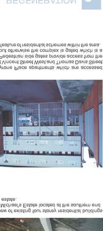
3 ST. MICHAEL S ESTATE- INCHICORE 2.0 Site Description & Background 3.0 Planning Context 3.1 Development Plan Zoning Objectives The St. Michael's Estate flat complex was completed in the early 1970's and was one of several Local Authority flat complexes of pre-fabricated construction. A combination of great community involvement, parish activities and close proximity to services, all contributed to a successful residential development throughout the 70's and early 80's. However, social and maintenance problems over time saw the estate fall into decline. The site is located on the south side of Emmet Road, bounded to the west by St. Vincent's Street, to the south by Goldenbridge Cemetery and the Grand Canal and to the east by the residential complex at Bulfin Court and Connolly Avenue, approx 3kms south west of the city centre. The immediate area is currently predominately residential in use, although located very close to the commercial activity of Inchicore village. The site can be divided into two parts, a 4 acre site and a 10 acre site. The 4 acre site is a cleared brownfield site located to the south adjacent to the cemetery and the Grand Canal and is the subject of a Part 8 planning permission. The 10 acre site currently comprises the remainder of the flat complex, parish and community buildings, a pigeon club, a health centre and traveller accommodation. The entire site has an area of approximately 14 acres/5.66 ha with a frontage onto Emmet Road of approx 110m. The site is zoned under the 2005 Dublin City Development Plan as Z13 to seek the social, economic and physical rejuvenation of the area. This designation indicates the importance of mixed-use development, full integration of proposals on site with the surrounding area and the importance of incorporating high quality public amenities as part of a regeneration. Under the Z13 zoning category, the following uses are included as permissible uses although under this designation other uses not stated can be considered on their merits: Permissible Uses: Buildings for the health, safety and welfare of the public, Childcare, Cultural/ Recreational Buildings, Education, Enterprise Centre, Hotel, Light Industry, Media Uses, Medical Uses, Office, Residential, Shop (neighbourhood scale). Surrounding zonings and designation of notice include: The Z4 mixed use commercial zonings of Inchicore Village. The Z1 residential areas adjoining include residential streets to the west of St Vincent Street West such as Emmet Crescent and Emmet Court and residential streets to the east that connect with Bulfin Road, Goldenbridge Avenue and Suir Road and in turn the South Circular Road. Z6 enterprise and employment zonings that include pockets of potential redevelopment opportunity sites to the north adjoining the Camac and more extensively a short distance south fronting Davitt Road and the Grand Canal. The Z9 open space and recreational amenity zone which includes the Camac River Valley park to the north, the grounds of Richmond Park to the north, the Grand Canal to the south and Goldenbridge Cemetery (an important heritage feature) at the south end of the site. The protected structures which provide strong character and opportunity for the site including St Michael's Church, old St Michael's CBS stone buildings and Goldenbridge Cemetery. Z15 Institutional zoning that includes the sites of Inchicore College and Technical School adjoining Emmet Road and Luby Road a short distance east. Site Location 2
4 ST. MICHAEL S ESTATE- INCHICORE 3.2 Area DemographicAnalysis and Socio EconomicAnalysis. An analysis of the local area population levels, age profiles and economic status are important indicators to highlight the character of the local community who can benefit from and importantly contribute to the success of a regeneration plan. It is important that adequate community facilities, support for family structures, facilities for the elderly, facilities for children and teenagers etc are considered and have relevance to the actual profile of the local community. Equally, such an analysis can indicate likely demand to invest in new housing opportunities, to gain employment, to support and initiate small business activities, to visit and support leisure, community and cultural facilities etc Census of Population was reviewed for the purposes of this study. St Michael's Estate is located within the District Electoral Ward (DED) of Kilmainham C. There are 4,292 persons recorded. 35% of that local population are within age category, 23% in the 40-64, 17% in the 0-14, 14% in the and 11% in the over 65 categories. In the wider local area, which included an analysis of the DED's of Kilmainham B, Kilmainham C, Ushers A, Ushers F and Inchicore A, a total of 13, 116 persons are recorded. 37% of that local population are within the age category, 24% in the 40-64, 14% in the over 65, 13% in the and 12% in the 0-14 categories. Diagram 1 below illustrates these categories Of the wider area local population, people within the combined ages of comprise 46% of the overall population. This is considered a positive indicator for the reasons of (a) a youthful population structure in the wider local area will help to strengthen a sense of neighbourhood both in the present and into the future (b) people within this category have a lot to contribute in both participating in and creating opportunities for community initiatives, cultural activities, leisure activities etc all of which provide character and identity for the local area (c) people within this age bracket are usually at an age of new household formation, looking for a first home, raising families, looking for opportunities to create a business or gain employment etc. All of these activities could have a positive interaction with opportunities created by new development in the locality whether they are of a residential, commercial or community character. Diagram 2 illustrates this comparison. The same wider local area was analysed for the economic status of the local community. The findings identified a total of 11,492 persons aged 15 and over and their status is summarised as; 59% are at work, 13% are retired, 7% are looking after the family home, 7% are students, 6% are unable to work due to illness or disability, 6% are unemployed, 1% are looking for first regular job and 1% in an other category. Diagram 3 below illustrates these findings. The high recording for those at work coupled with the young age cohorts are positive indicators for the regeneration of the site and its integration with the wider area. Inchicore and Environs Age Profile Age Profile as % of Total Inchicore & Environs Population Inchicore & Environs Persons Aged 15 and Over by Principal Economic Status At Work % % % % % Other Ages 54% Group 46% Group Other Ages Looking after family 7% Student 7% Unemployed 6% Retired 13% Unable to w ork due to sickness/disability 6% Other 1% Looking for First Regular Job 1% At Work 59% Looking for First Regular Job Unemployed Student Looking after family Retired Unable to w ork due to sickness/disability Other Diagram 1 : Population Age Categories Diagram 2 :Age group Comparsion Diagram 3 :Economic Status of persons Aged 15 and Over 3

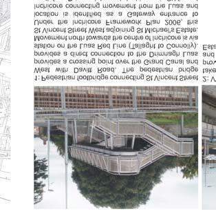
5 ST. MICHAEL S ESTATE- INCHICORE Of note for St Michael's Estate, the Framework Plan includes the following designations: 1. Two Strategic Gateways into Inchicore from the wider area converge at Michaels Estate. They signal entry points and nodal points for the village. They announce arrival into Inchicore from important routes. They include St Michael's Church to the North East at the junction of Bulfin Road and Emmet Road and the Luas Station (Drimnagh stop) on Davitt Road to the South East. 2. A Threshold Gateway to the village centre is identified at the north west site corner at the junction of St Vincent Street West and Emmet Road. This is recognised as an entry point to the very heart of Inchicore Village and highlights the importance of the main road boundaries of the site, in particular Emmet Road and St Vincent's Street West, as an interface with the village. ST.MICHAEL S ESTATE 3. Permeability is important with possible routes north to south ( from the Canal to Emmet Road) and east to west (from the direction of Bulfin Road to St Vincent Street West) highlighted as important movement routes. 4. The importance of heritage and natural amenity is an asset for Inchicore with opportunities to highlight the value of such features as Goldenbridge Cemetery, the protected structures of Richmond Barracks, St Michaels Church and natural amenities along the Grand Canal and River Camac within redevelopment proposals. Luas Line F Route Option : RPA Map from transport 21 Map from Inchicore Framework Plan showing Strategic Gateways and Threshold Gateways in context of St. Michael s Estate 3.3 Transport Connections 3.4 Integration with Inchicore Framework Plan The site benefits from strategic public transport access, both existing and proposed. The Emmett Road frontage of the site is accessible to city centre bus services. The No 51 B/C/N Bus Service has a station on Emmet Road providing connections between the City Centre and Clondalkin. The existing Luas Red Line (Tallaght to Connolly Station) follows a route along the Grand Canal close to the south site boundary. A Luas stop (the Drimnagh stop) is within close walking distance via St Vincent's Street West and a new pedestrian bridge across the Canal. Under Transport 21, the Luas Line F from Lucan to the City Centre (College Green) has two options. Option 1 would take a route along Emmet Road directly adjoining the north site boundary. Option 2 would utilise the existing Red Line corridor a short distance south of the site. Both options provide advantages to connect the site strategically with city public transport. The diagram above is taken from Transport 21 and indicates the route alignment options for Luas Line F in the contextt of St Michael's Estate. The Inchicore Framework Plan 2006 provides guidance for the development of twelve opportunity sites in Inchicore Village. Design briefs are provided for these sites to co-ordinate appropriate site layouts, building heights, mix of uses etc. The plan also co-ordinates the re-development of these sites with an overall vision for enhancing the character of Inchicore Village. An example of this is the creation of a linear riverside park along the Camac. A design brief was not prepared for St Michael's Estate as part of this plan on account of the parallel rejuvenation proposals for the estate. Integration of the estate with the rejuvenation of the wider area was however promoted. The opportunity now exists to co-ordinate this integration, particularly when progress under the Inchicore Framework Plan is advancing ST.MICHAEL S ESTATE 4
 in the context of St. Michael s Estate 3.")


6 ST. MICHAEL S ESTATE- INCHICORE HEUSTON GATEWAY FRAMEWORK PLAN 2003 PRESENT INCHICORE FRAMEWORK PLAN 2006 CURRENT PLAN Map from the Inchicore Framework plan showing the concepts for opportunity site infill development ( 12 Opportunity Sites in total ) in the context of St. Michael s Estate 3.5 Integration with Other Planning Initiatives in the WiderArea Anumber of other planning initiatives in the wider area highlight the strategic nature of the location in Inchicore. Activity and regeneration in these areas should have benefit for the wider area with opportunities for linkages and connections between the types of activity at each location. The overall increase in investment, increase in local population, heightened business activity and employment, enhanced community facilities, improved recreation and culture facilities and creation of interesting new places to visit should have shared benefits throughout the wider area. These plans include the Draft Drimnagh Integarted Area Plan 2008, Draft Liberties Local Area Plan 2008 and the Draft Naas RoadAction Plan Draft Drimnagh IntegratedArea Plan 2008: NAAS FRAMEWORK PLAN 2008 UNDER PREPARATION DRIMMNAGH LOCAL AREA PLAN 2008 CURRENT PLAN LIBERTIES LOCAL AREA PLAN 2008 COMMENCING Map showing the general location of planning initiatives across the wider area including the more recent planning initiatives in the context on St. Michael s Estate 6 This plan includes character zones and landuse designations which are in close proximity to St Michael's Estate including lands south of the Grand Canal and Davitt Road. Opportunities for the rejuvenation of industrial sites for a wide range of mixed uses including residential, commercial and community uses are identified along the landbank facing Davitt Road and the Grand Canal. Important recreational amenities such as sports facilities at Brickfields Park are identified. The promotion of permeable movement connecting these areas including movement north towards Inchicore via St Vincent Street West are identified. Both St Michael's Estate and these lands share common advantages with the Luas line and amenities of the Grand Canal. Draft Liberties Local Area Plan 2008: Moving from the Kilmainham/Inchicore area to the city centre via the James's Street and Thomas Street Corridor is an important route and creates close ties between the Kilmainham/Inchicore Area and the Liberties. The Draft Liberties Local Area Plan has identified 11 character areas and put forward detailed redevelopment briefs for each area. Enhancing the physical and social character of these areas is a priority and importantly restoring and highlighting the unique heritage of the area is key to these strategies (for example St James's Harbour and the restoration of the Grand Canal basin). The proposals aim to extend dynamic mixed use city quarters with environments that attract visitors through the area in addition to new residents and employees generated by the redevelopments. Continued movement westwards would link with Kilmainham/Inchicore. It is important that a strategy for St Michael's Estate contributes to the creation of interesting places to continue to draw investment and interest further west in the direction of Inchicore. The Draft Naas Road LocalAction Plan 2008: Another current planning initiative to the west of Inchicore is under preparation to give effective guidance for the regeneration of significant industrial landbanks. Mixed use urban quarters with a high emphasis on employment generation will be co-ordinated under this plan. Existing and future proposed public transport links connect this area closely to Inchicore and the city centre in turn. These areas are currently characterised by large low density industrial premises with large areas of open storage (car storage, retail warehouse trading etc). Developing these areas as significant mixed use urban quarters will provide gateway developments to the city centre and place Inchicore centrally between these up and coming activity areas and the city centre. 5


7 DEVELOPMENT OPPORTUNITIES 4.0 Comments on Development Potential SUMMARY Inchicore has experienced many changes to the physical and economic environment over the past ten years. While it has benefited in the past from the boom in the residential property market and this has resulted in new apartment developments along Emmet Road, Tyrconnell Road and Grattan Crescent, this expansion was not experienced in the local commercial property sector. This is evident by the number of vacant retail/commercial units in the Inchicore area and the shortage of quality tenants. The land use within the village currently comprises financial institutions, several public houses and in general a mixture of smaller retail/commercial activities. More recent developments have seen the opening of a Eurospar and Tesco Express as well as a restaurant/winebar. One of the main concerns of residents and the local BusinessAssociation is the absence of a major supermarket retailer in the village or surrounding vicinity. Local residents have to travel some distance to the nearest supermarket i.e. Ballyfermot, Crumlin and even Thomas Street. The inclusion of a large supermarket facility would also attract shoppers from outside the immediate area which would have a positive knock-on effect to commercial activity in the area. St Michael's Estate is very well located in close proximity to the city centre and to the Naas Road. It has the benefit of both a public bus service along Emmet Road and the Luas Drimnagh stop at the Southern end of the site with potentially a new line through Inchicore village. However, the village does not have sufficient car parking facilities, which is an obstacle to trading and therefore, the provision of convenient and secure car parking should be an essential element of any commercial proposal. While the current economic climate does not favour any speculative development, there is a definite demand for this form of retail outlet from owner occupiers in Inchicore. Market research and demographics stated previously would also support supermarket development and ancillary retail and restaurant units. INCHICORE Diagram highlights the Development Opportunities and Connections between Character Areas for St. Michael s Estate and ite adjoining area Strong connections to Inchicore Village Centre High quality Commercial and Community Services to extend and strengthen the role of the village Strong permeability through the site Strong connections to Health Services Integration of the 4 Acre Residential Site Integrate existing Heritage and Amenity with new community 7 8 Strong connections to to the Luas Corridor Connections to community services and schools 9 Inviting entrance to integrate residential area to east 6
8 CHALLENGES 5.0 St Michael's EstateArea Challenges: Challenges are identified as they highlight where improvements can be made and how improvements might be incorporated into future regeneration proposals. The challenges are identified for both the immediate site and also the site's interactions with the surrounding area. Some of the key challenges are: The poor visual character of the site's principle roadside boundaries. Poor first impressions are created, particularly on approach from Emmet Road. The lack of a streetscape and active frontages do not encourage movement through the site. Despite the close proximity of the site to the village centre of Inchicore, the site feels isolated and disconnected from the surrounding village area. Apartment residential developments in the area have a gated character which adds to the impression of poor connections and lack of integration. The residential area to the east of the site backs onto St Michael's Estate along a significant common boundary, a further reinforcement of isolation within the location. On approaching St Michael's Estate from the west along Bulfin Road, the Church and tree planting provide positive street character. Views into the estate however do not particularly invite or encourage continued movement as a natural extension of the street network. The area has significant natural and heritage features such as the Camac River Valley, the Grand Canal and Goldenbridge Cemetery. The estate does not however connect successfully with these amenities which could offer substantial benefit to the character of the estate and its integration with surrounding character. POOR INTEGRATION WITH CANAL AMENITIES BARRIERS TO ACCESS CAMAC RIVERSIDE AMENITY GOLDEN BRIDGE CEMETERY HIDDEN WITHIN THE AREA EXAMPLES OF SITES WITH GATED DEVELOPMENT POOR VISUAL CHARACTER - LACK OF STREETSCAPE POOR DRAW IN CHARACTER AT INTERFACE BETWEEN ESTATE AND RESIDENTIAL AREA TO THE EAST POOR INTEGRATION WITH SURROUNDING HOUSING AREA POOR INTERFACE BETWEEN VILLAGE CORE AREA AND FRONT BOUNDARIES OF ESTATE 7


9 OPPORTUNITIES 6.0 St Michael's EstateArea Opportunities LUAS ROUTE OPTIONS LOCATION OF PARKS AND RECREATION NEIGHBOURHOOD SHOPS There are significant positive opportunities for St Michael's Estate. Regeneration proposals can harness such potential. Some of the key opportunities are: St Michael's Estate is immediately adjacent to key community facilities for the local area including the Goldenbridge Integrated Services Complex and Our Lady of Lourdes National School to the west off Emmet Close, existing on site health, sports and parish services and future proposed community health services on the CBS lands ( former Richmond Barracks to the east). Combined future community services as part of a regeneration plan, the location has area wide importance for key community services. GATEWAY AND THRESHOLD LOCATIONS TO INCHICORE HISTORICAL LANDMARKS LINEAR PARK AMENITIES RECENT OR PLANNING PERMISSION APPROVED FOR INFILL DEVELOPMENT RESIDENTIAL, MIXED USE ETC COMMUNITY FACILITIES VILLAGE CENTRE LUAS STATION INDUSTRIAL AREAS WITH FUTURE MIXED USE INVESTMENT POTENTIAL The site is adjacent to three identified gateways into Inchicore under the Inchicore Framework Plan 2006 which include the Luas stop to the south west, St Michaels Church / Bulfin Road junction to north east and the junction of Emmet Road and Vincent Street West (a threshold point on entering the centre of the village) at the north west corner. LUAS LINE F OPTION In addition to the Luas corridor to the immediate south, the location also benefits from bus service access on the north boundary and future proposed Luas route options to the north and south. Connections to the wider city area by public transport are existing and will be further extended. The site adjoins significant amenity, leisure and heritage features such as the Grand Canal, Goldenbridge Cemetery, Camac River Valley, Richmond Park, protected buildings including Richmond Barracks and St Michael's Church etc all of which provide unique character, opportunities for amenity value and opportunities for a special identity for the location. The site is a key site within the village which has a number of other opportunity infill redevelopment sites. Some are under progress and others are identified within the Inchicore Framework Plan In the wider area the location is close to significant opportunity sites and amenity areas identified under the Drimnagh Integrated Area Plan (Draft) 2008 and other planning initiatives. The site has a major role to play in promoting inward investment and regeneration across the wider area. LUAS LINE F OPTION The site offers opportunities to create new spaces, new streets and new connections both north to south and east to west as an extension of the existing network of village streets and public spaces. For example walking between the village centre to the west towards the local shop facilities on Bulfin Road to the east through new high quality active streets will be possible and encouraged. Map showing the Opportunities for St. Michael s Estate and its adjoining Area 8


10

 which provide distinctive character to the")


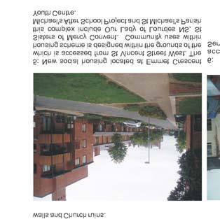
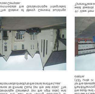
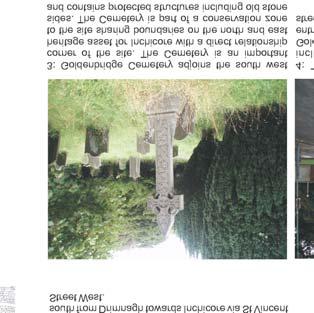
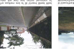
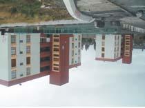
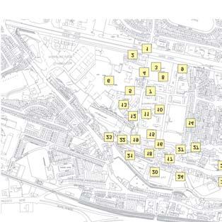
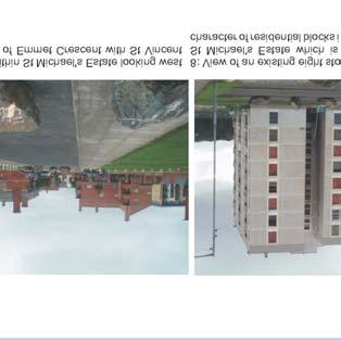
11 PHOTOGRAPHIC SURVEY 13: Thomas Davis Street West has a wide variation in building character including two storey and single storey housing fronting the street and more recent higher density infill development including a new apartment scheme permitted in 2004 (application sought 140 apartments in blocks ranging between 3-7 storeys). 14: The façade of the old stone buildings of the former Richmond Barracks (later St Michael's CBS) which provide distinctive character to the internal street that connects St Michael's Estate with Bulfin Road. The stone buildings are protected structures and possess planning permissions for conversion and reuse for a Primary Health Care Unit and a Community Nursing Unit. 19: The northern end of St Vincent Street West on 20: The entrance to Richmond Park located on approach to Emmet Road. The visual quality of the Emmet Road opposite the north boundary of St street is eroded by the lack of street definition, quality Michael's Estate. of the public realm etc. This location has significant opportunity however. The junction of St Vincent Street West and Emmet Road is recognised as a Threshold Location under the Inchicore Framework Plan 2006 ( i.e an entrance point to the village centre). 25: Further example of residential development adjoining the Camac River. This scheme is accessed from Turvey Avenue. These developments strengthen the residential base for the village centre and provide opportunities to address the Camac River with walkways, supervised open space etc.the gated nature of many schemes however prevents full permeability through these back land sites as en extension of the existing village centre streets. 26: Inchicore College and Technical School located on institutional zoned lands at the junction of Luby Road and Emmet Road. 15: View looking west at the boundaries of the St 16: Viewoftheexisting SportsCentrebuildingtothe Michael's Sports Centre building and adjoining pitch right and elderly housing to the left and the estate which are located on the north end of the site. road which connects St Michael's Estate with Bulfin Road. 21: The character of village centre streets in Inchicore 22: View of the centre of Inchicore Village moving are comprised of two storey red bricked buildings, west from St Michael's Estate along Emmet Road. many with ground level commercial use and first floor Commercial frontages at ground level include a residential. Eurospar. The overall representation of high quality retail units and in particular larger convenience stores is lacking. There are opportunities however to lift the physical environment and economic vibrancy in the centre of Inchicore with a rejuvenation St Michael's and in particular with new uses and activity on the Emmet Road frontage to the estate. 27: Example of the higher topography to the east of St Michael's Estate. This view looks towards Kilmainham Jail (looking north from Luby Road).Such views highlight the close proximity of the area to such important city landmarks. 28: A row of local neighbourhood shops accessed from Bulfin Road which provide valuable retail amenities for local residents. This row of shops, which includes high quality butchers, a bakery etc are a positive example of neighbourhood services and are a short distance west of St Michael's Estate. 17: St Michael's Catholic Church which is located at 18: The Emmet Road frontage to the estate is 23: View of village centre streets in Inchicore moving 24: Example of modern residential development in 29: St Michael's Church as viewed from Bulfin Road 30: Example of the two storey residential character to the north east corner of St Michael's Estate. The characterised by the Health Centre building, car east in the direction of St Michael's Estate. There are Inchicore. This scheme. Kilmainham Bank, adjoins approaching St Michael's Estate from the east. This the east of St Michael's Estate (Connolly Avenue building is a Protected Structure and adds park, stone wall boundary and views of St Michael's examples of recent infill redevelopment with ground the Camac River. It is a gated development with location is recognised as a nodal point and gateway shown in this view). considerable character to the streetscape. The Church is visible from Emmet Road from where a pedestrian access connects with St Michael's Estate and the entrance to the Church. Under the Inchicore Framework Plan, the nodal or focus point of the Church. The ground levels on the site are higher than the adjoining street. Bus stops for the village centrearelocated alongthisfrontage level commercial and overhead office and residential uses. There are however instances of vacancy. Increasing the overall vibrancy of Inchicore through significant regeneration in St Michael's Estate will benefit investment in other parts of the village centre. access for residents from Emmet Road. for Inchicore under the Inchicore Framework Plan Church, at the end of Bulfin Road, is recognised as a Gateway on approach to Inchicore. The Church and its setting are an asset for the local area and the estate. 10


12 ST. MICHAEL S ESTATE - PROPOSALS 8.0 Existing Structures on site EXISTING STRUCTURES ON SITE KEY 1.0 HEALTH CENTRE 2.0 PARISH CENTRE 3.0 TRAVELLERS ACCOMMODATION 4.0 PIGEON CLUB 5.0 PITCHES 6.0 VEC SPORTS HALL 7.0 FAMILY RESOURCE CENTRE Richmond Barracks 1837 Richmond Barracks EXISTING BLOCK 9.0 PART VIII SECURED Richmond Barracks 1908 Richmond Barracks 1963 Existing Occupancy


13 ST. MICHAEL S ESTATE - PROPOSALS 9.0 Current proposals compared to previous proposals Original Original RFP RFP Preferred Preferred Bidder Bidder Proposal Proposal 2 nd Bidder 2nd. Bidder Proposal Proposal Dublin City Council Proposal Dublin City Council Proposal 137 Social & Affordable units 137 Social & Affordable units on the Part 8 site onthe 4acresite Phase 1 76 units plus community. Phase 2 61 units Community Building 120 sq.m Community Building / Part 8 site 120 sq.m Community Creche 320 sq.m Community Creche / Part 8 site 320 sq.m 583 private, social and affordable units mixed residential development comprising of social, affordable and private units. Commercial retail 4,000 sq.m 4,043sq.m 3,994 sq.m Commercial retail 2,500 sq.m anchor tenant plus approx 3,000 sq.m ancillary retail. Civic centre (incl. library, parish centre, DCC and community offices) 2,725 2,800 sq.m 2,726 sq.m Civic centre (incl. library, parish centre, DCC and community offices) 2,725sq.m. - Youth Café 200 sq.m Youth Café 200 sq.m Family Resource Centre 500 sq.m Phasing to be re-considered Phasing to be re-considered Family Resource Centre 500 sq.m Creche (2 no.) 1,200 sq.m Creche (No 2) - 1,000sq.m Health Centre - 1,200 sq.m Health Centre and Nursing Care unit to be relocated on CBS lands 1,300 sq.m Relocation of existing playing pitches. Underground pitches Relocation of pitches. Playing pitches to be relocated in new urban plaza. Regeneration to act as a catalyst for the overall upgrading of the Inchicore Area. Regeneration to act as a catalyst for the overall upgrading of the Inchicore Area. Dublin City Council to prepare design codes for : Inclusion of the fundamental principles of the RFP Define the design standards required for all future development Establising detailed development requirements and deliverables for materials, area, services, finishes, maintenance, performance specifications etc. Identify key standards and codes to be adhered to in design and construction, along with mechanisms for verification of compliance delivery throughout the life of the project Establishing management and maintenance standards and regimes to ensure successful implementation of the poject after completion 12

14 ST. MICHAEL S ESTATE - PROPOSALS 10.0 Timescale Projections PHASE PHASE PHASE


15 ST. MICHAEL S ESTATE - PROPOSALS 11.0 MASTER PLAN PHASE PHASE 1 : PHASE 2 : PHASE 3 : Phase 1 of 4 acre site development- 76 units, 32 social, 44 affordable plus community use. Establish new urban plaza with football pitches. Detenant front commercial site. Phase 2 of 4 acre site development - 61 residential units, 36 social, 25 affordable Construct new commercial / community frontage. Develop urban plaza Develop remainder of the residential site. 450 private units including 20% social and affordable. Develop stand alone Family Resource Centre with civic space. Complete urban plaza 14

16 ST. MICHAEL S ESTATE - PROPOSALS 12.0 Height Strategy and Urban Design principles TREE LINED AVENUE 6 STOREY POPUP VEHICULAR TRAFFIC VEHICULAR TRAFFIC WITH PEDESTRIAN PRIORITY PROSPECT C R R 3 H H HH R R RECREATION C C CIVIC SPACE HH HEALTHCARE C PROTECTED STRUCTURES MIXED USE DEVELOPMENT C 6 8 COMMUNITY ELEMENTS 7 1 URBAN FORM - HEIGHT STRATEGY REINFORCE PRINCIPLES OF THE RFP: Intergration with the wider Inchicore Village. Permeability through the site. Pedestrian links to/from luas through the development. Provision of suitable economy retail anchor tenant Height limit of 5 stories throughout the site. 4 storey development fronting onto Emmett Road. Development to be informed by rich local history /heritage Social housing to be 3 clusters High quality public spaces to include; liveable streets, public plaza, high quality open space 10% of all unit types to be designed for wheelchair users. Lift to be provided in residential cores over 3 storeys. Stair cores serving no more than 10 units or 40 bed spaces. URBAN FORM - PROPOSED LAND USAGE LIBRARY / DCC OFFICES / COMMUNITY OFFICES 2 SHARED FOYER SPACE 3 PARISH CENTRE 4 YOUTH CAFE 5 5 A SIDE PITCHES 6 FAMILY RESOURCE CENTRE 7 CRECHE 8 COMMUNITY BUILDING 15


17 ST. MICHAEL S ESTATE - PROPOSALS 16


18 ST. MICHAEL S ESTATE - PROPOSALS 13.0 Restoring the Urban Grain EXISTING FIGURE AND GROUND PROPOSED FIGURE AND GROUND


19 ST. MICHAEL S ESTATE - PROPOSALS Site Analysis Privacy & Amenity Adaptability Public Realm Parking Layout Detailed Design Distinctiveness Context Efficiency Connections Variety Inclusivity POLICY 1 - CONTEXT POLICY 2 - CONNECTIONS POLICY 3 - INCLUSIVITY POLICY 4 - VARIETY POLICY 5 - EFFEICIENCY DOE Guidelines on sustainable Urban Housing : Best Practice Guide Lines POLICY 6 - DISTINCTIVENESS POLICY 7 - LAYOUT POLICY 8 - PUBLIC REALM POLICY 9 - PUBLIC AMENITY POLICY 10 - PARKING POLICY 09 - ADAPTABILITY - to be established as part of the Design Code Document POLICY 12 - DETAIL DESIGN - to be established as part of the Design Code Document 18

20 ST. MICHAEL S ESTATE - PROPOSALS SUMMARY This Taskforce was convened in August 2008 to examine the options available for the successful regeneration of the Dublin City Council Housing Estates at St. Michaels Estate Inchicore, O'Devaney Gardens and Dominick Street. A Multi-disciplinary team was formed comprising members from the Housing Dept, City Architects, the Planning Dept, and Valuers Section. The work of this team involved re-examining the commitments contained within the RFP's and community charters, and examining ways in which to deliver the main agreed principles in each case. In re-examining these projects it was necessary to have regard to the changed economic climate and in particular to changes in the residential housing market. The need to re-examine each of the projects also presented an opportunity to propose enhancements to each project, in particular for the delivery of public open space, commercial development and overall densities. Where changes to the original RFP's are proposed, reasons and benefits for the changes are provided. However the proposals do maintain the original objectives for these sites in seeking to promote the creation of balanced sustainable communities, with a mix of commercial and community uses, social, affordable and private housing and establishing appropriately scaled public open spaces. These proposals differ fundamentally from the original Public, Private Partnership process in that the projects are not developer led. It has therefore been necessary to review deliverables and timeframes, and each development will require frontloaded funding in order to deliver the proposed regeneration over time. Dublin City Council are proposing to seek Department funding for the social and affordable housing element and some of the community structures in each area and to develop an agreed site master plan for commercial and private residential developments when the market is ready. It is envisaged that the release of equity from the sites will contribute to the funding of these projects. The proposals contained in this report seek to be realistic in terms of what can be achieved, over what timeframe and at what cost. There is also a commitment to maintaining the quality in each scheme and proposed enhancements where appropriate. The proposals are now put before the Council and if agreed will form an integral part of the City Council's Housing Action Plan. Overall delivery and funding is subject to the necessary approval of the Department of the Environment Heritage and Local Government. St Michael's Estate Summary of next steps Presentation to City Council Presentation to Regeneration Board 2009 Preparation of Project Brief for funding application to DoEHLG Development and implementation of detailed timeframe for relocation of individual uses at Emmet Road end of site. Design development and preparation of tender documentation for first phase of residential development at canal end of site. Delineation of Parade Ground Square. Drafting of Design Development Brief for mixed use commercial site at Emmet Road end of site 2010 Go to tender/ start on site first phase of residential development. Go to market with commercial site. 19
Housing Land Initiative. Feasibility Study. Update
 Report to the Housing & Community Strategic Policy Committee Housing Land Initiative Feasibility Study Update September 2016 Oscar Traynor Road Site Site Description Dublin City Council owns a 17.014 ha
heuston gateway: sections heuston gateway: regeneration strategy and development framework plan
 B B1 A B1 B C A heuston gateway: sections B B1 C 117 4.3.3 Zoning The station is the central hub of the area and this function must be preserved and developed. However large areas of the Heuston Station
Page 1 of 19 URBAN DESIGN FRAMEWORK FOR BOLTON STREET WATERFORD
 Page 1 of 19 URBAN DESIGN FRAMEWORK FOR BOLTON STREET WATERFORD 1.0 Introduction: The relocation of the City Council stores and depot from Bolton Street creates an exciting opportunity for development
2.0 Strategic Context 4
 2.0 Strategic Context 4 2.1 The Area Action Plan is a non-statutory plan, which forms a corporate policy document, expressing particular issues and areas of concern while also providing a vision for the
6 Site Framework Strategies
 6 Site Framework Strategies 6.1 Introduction Section 6 identifies a number of specific areas which are considered to be key sites within the Plan area and which may have potential for development / redevelopment.
A. The sites in Table 16 below, as identified on the Policies Map, are allocated for retail-led development:
 SWDP 44: Worcester City Centre A. The sites in Table 16 below, as identified on the Policies Map, are allocated for retail-led development: Table 16: Sites Allocated for Retail-Led Development Policy Reference
20. Ballysadare Mini-Plan
 20. Ballysadare Mini-Plan 20. Ballysadare Mini-Plan Community facilities Ballysadare has a wide range of community facilities: a primary school, St Mary s College (secondary school), a health centre, playing
ALTERNATIVE PROPOSAL FOR TRI LOCATED NATIONAL PAEDIATRIC HOSPITAL BY 2016 ON A 20.5 ACRE (8.3 HECTARE) SITE
 SITE") ALTERNATIVE PROPOSAL FOR TRI LOCATED NATIONAL PAEDIATRIC HOSPITAL BY 2016 ON A 20.5 ACRE (8.3 HECTARE) SITE EXECUTIVE SUMMARY This is a viable and achievable proposal to realise an iconic tri located National
ALTERNATIVE PROPOSAL FOR TRI LOCATED NATIONAL PAEDIATRIC HOSPITAL BY 2016 ON A 20.5 ACRE (8.3 HECTARE) SITE EXECUTIVE SUMMARY This is a viable and achievable proposal to realise an iconic tri located National
stakeholders Zoning Conservation Connections
 4.7.1 Zoning The Phoenix Park site is identified as an important gateway site to the city. The site should be developed as a landmark public building with office or cultural use. The present zoning, Z9,
4.00 STAKEHOLDERS. urbanprojects
 4.00 STAKEHOLDERS 94 heuston gateway: regeneration strategy and development framework plan 95 The Heuston Gateway presents one of the greatest concentrations of brown field development sites located adjacent
3.3. Urban Structure Defining a New Hierarchy of Routes and Spaces >Images
 Section 3.0 I The Masterplan Framework 18 >Images Examples of high quality routes and spaces 3.3. Urban Structure The success of any masterplan lies in a clear definition of the future urban structure
Woodbrook - Shanganagh
 Section 4: Key Sites Framework Strategy Woodbrook - Shanganagh Local Area Plan 2017-2023 4. Site Framework Strategies The Master Plans shall have regard to the thematic objectives under the LAP Development
Chapter 2: OUTLINE PLANNING APPLICATION PROPOSALS. A New Garden Neighbourhood Matford Barton 17
 Chapter 2: OUTLINE PLANNING APPLICATION PROPOSALS A New Garden Neighbourhood Matford Barton 17 2.1. SUMMARY AND STATUS OF THE PROPOSALS 2.1.1. The parameter plans and associated wording in this chapter
17. Coolaney-Rockfield Mini-Plan
 County Development Plan 2017-2023 Consolidated Draft + Adopted Amendments - August 2017 17. Coolaney-Rockfield Mini-Plan Village profile Coolaney is located approximately 23 km to the south-west of Sligo
Vision for Irvine: a self-confident town where people aspire to live and work and which they are proud to call home
 Vision for Irvine: a self-confident town where people aspire to live and work and which they are proud to call home Stunning view out to the harbourside Artist s impression of how the Bridgegate area could
REPORT BACK BROADSHEET 3 May 2016
 Paddington Place REPORT BACK BROADSHEET May 06 Architects and planners should work with the community first and then thinking about developers profits second. - Quote from participant at Paddington Place
Chapter 5 Urban Design and Public Realm
 5.1 Introduction Public realm is all areas of the urban fabric to which the public have access. It is where physical interaction takes place between people. It therefore, includes buildings and their design,
GREENFORD HALL & ADJOINING LAND
 GREENFORD HALL & ADJOINING LAND CONTENTS 1. Introduction 1. Introduction 2. Urban Context 2.1 The Site and Surroundings 2.2 Urban Context Map 2.3 Access and Movement 3. Planning Context 3.1 Planning History
elbridge Core Strategy
 C elbridge Core Strategy Celbridge is designated as a Moderate Growth Town in the RPGs. The County Development Plan reinforces this designation in its settlement strategy. Moderate Growth Towns within
development framework
 dublin city council: heuston gateway regeneration strategy substudy document: guinness udv lands Guinness UDV Lands development framework Dublin City Council Steering Group: Sean Carey Ast. City manager
Newcourt Masterplan. November Exeter Local Development Framework
 Newcourt Masterplan November 2010 Exeter Local Development Framework Background The Exeter Core Strategy Proposed Submission sets out the vision, objectives and strategy for the development of Exeter up
PUBLIC REALM STRATEGY
 CONSULTATION DRAFT PUBLIC REALM STRATEGY Trenchard Street & Frogmore Street City Design Group Place Directorate Public Realm Strategy Trenchard Street & Frogmore Street Contents 1. Introduction 2. Understanding
MOUNT AVENUE MASTERPLAN WORKING DRAFT NOVEMBER 2006
 MOUNT AVENUE MASTERPLAN WORKING DRAFT NOVEMBER 2006 1 1. OVERALL MASTERPLAN IDENTITY: Dun Dealgan motte and bailey The Dun Dealgan motte and bailey, a national monument, is located to the north east of
C. Westerly Creek Village & The Montview Corridor
 C. Westerly Creek Village & The VISION Community Vision When the goals of the city are achieved Westerly Creek Village, a distinctive community defined by Montview Boulevard and Westerly Creek, is a strong
Oscar Traynor Road Land Initiative Project
 Oscar Traynor Road Land Initiative Project Page 1 INTRODUCTION This report has been prepared as a follow up document to the Housing Land Initiative Feasibility Study presented to the joint Housing and
PLANNING STATEMENT. Market House Market Place Kingston upon Thames KT1 1JS
 PLANNING STATEMENT To support planning and listed building consent applications for change of use from Class A1 shop and Class A3 cafe to Class A3 restaurant at: Market House Market Place Kingston upon
Description Details submitted pursuant to discharge of condition 5 (Design Code) attached to planning permission 13/01729/OUT.
 attached to planning permission 13/01729/OUT.") ITEM 9 Application Number: 18/00266/DISCON Description Details submitted pursuant to discharge of condition 5 (Design Code) attached to planning permission 13/01729/OUT. AT The Point, 602 Midsummer Boulevard,
ITEM 9 Application Number: 18/00266/DISCON Description Details submitted pursuant to discharge of condition 5 (Design Code) attached to planning permission 13/01729/OUT. AT The Point, 602 Midsummer Boulevard,
Table of Contents. Elm Avenue Improvement Plan City of Waco, Texas. Introduction 1. Existing Context 1 Figure 1 2.
 Table of Contents Introduction 1 Existing Context 1 Figure 1 2 Plan Guidelines 3 Future Urban Form 4 The West-End 4 Main Street 6 The East-End 7 Figure 2 9 Public Improvement Recommendations 7 General
City of Farmington. Downtown Plan. Amendment to the 1998 Master Plan Adopted October 11, 2004
 City of Farmington Amendment to the 1998 Master Plan Adopted October 11, 2004 Introduction Planning Background 1 Scope and Components of the Plan Amendment 2 Concept Introduction 3 Plan Concepts 3 Conceptual
13. London Bridge London Bridge Area Vision
 13. 13.1. Area Vision 13.1.1. is: A globally significant central London business district which is home to international business headquarters; Internationally renowned for its prominent riverfront location
OKEFORD FITZPAINE NEIGHBOURHOOD PLAN
 OKEFORD FITZPAINE NEIGHBOURHOOD PLAN Dear Parishioner, The Neighbourhood Plan Project Team have prepared this leaflet to summarise the full Neighbourhood Plan document. It provides a summary of the Vision,
28. Coolaney-Rockfield Mini-Plan
 28. Coolaney-Rockfield Mini-Plan 28. Coolaney-Rockfield Mini-Plan Community facilities Community facilities in Coolaney-Rockfield consist of a primary school, crèche, community centre, sports field and
CLOUGHJORDAN SETTLEMENT PLAN
 CLOUGHJORDAN SETTLEMENT PLAN 1.0 General Introduction and Development Context Location The market town of Cloughjordan lies close to the border with Offaly at the junction of the R490 and R491 Regional
Horwood Map of London, Westminster & Southwark First edition
 Barratt London is developing plans in tandem with Southwark Council and TfL to transform the southern end of Blackfriars Road. The residential-led, mixed-use scheme will deliver new private and affordable
BORRISOKANE SETTLEMENT PLAN
 BORRISOKANE SETTLEMENT PLAN 1.0 General Introduction and Development Context Location Borrisokane is located 15km north of Nenagh on the N52. While the town is primarily residential, it acts as a market
The Proposed Auckland Unitary Plan (notified 30 September 2013)
") 3 Business zones Introduction There are 10 business zones in the Unitary Plan: City Centre Metropolitan Centre Town Centre Local Centre Neighbourhood Centre Mixed Use General Business Business Park Light
3 Business zones Introduction There are 10 business zones in the Unitary Plan: City Centre Metropolitan Centre Town Centre Local Centre Neighbourhood Centre Mixed Use General Business Business Park Light
MALL REVITALIZATION CASE STUDIES
 MALL REVITALIZATION CASE STUDIES DECEMBER 9, 2012 MALL REVITALIZATION OVERVIEW Introduction Sample Case Studies prepared for Lacey Woodland District Steering Committee as it considers strategies to revitalize
DUBLIN DOCKLANDS MASTER PLAN AND RELATIONSHIP WITH OTHER PLANS
 .1 National Policy and Programmes.1.1 Sustainable Development A Strategy for Ireland, 1997.1.2 National Climate Change Strategy, 2007-2012.1. National Development Plan 2007-201.1.4 National Spatial Strategy,
SWLP 42: Worcester City Centre
 SWLP 42: Worcester City Centre A. The following sites are allocated for retail development (as shown on the Proposals Map): Policy Reference SWDP7/1 SWDP7/2 SWDP7/3 Sites allocated for retail development
3.0 Area-Wide Strategies 30
 3.0 Area-Wide Strategies 30 3.6 Tourism Strategy This section of the plan aims to develop and improve the tourism potential of the area. Strategic Context The City Plan outlines the potential of Cork to
Hockessin Community Redevelopment Plan
 Hockessin Community Redevelopment Plan 3.1 Introduction The Community Redevelopment Plan for the Village of Hockessin is the result of the people s vision for a distinct village center that serves as the
16. Peckham Peckham Area Vision
 16. 16.1. Area Vision 16.1.1. is: A lively town centre providing a range of daytime and night time activities on Rye Lane including a Library, a Leisure Centre and many independent retailers which specialise
Response to the London Bridge Area Vision and Site Allocations within the New Southwark Plan
 1 Melior Place London SE1 3SZ 020 7407 4701 teamlondonbridge.co.uk info@teamlondonbridge.co.uk 28 April 2017 Response to the London Bridge Area Vision and Site Allocations within the New Southwark Plan
Neighbourhood Planning Local Green Spaces
 Neighbourhood Planning Local Green Spaces Introduction... 2 1. Why green space is important... 4 2. Neighbourhood plans and green space... 6 3. Evidence... 8 Statutory designations... 9 Green space audit...
OPTIONS QUESTIONNAIRE
 OPTIONS QUESTIONNAIRE Mark the Yes column for each statement that you agree with Mark the No column for each statement that you disagree with Please complete all the statements if possible. Please add
2bPlanning Scheme. Appendix. Conservation - Removal of Structures. Grangegorman
 Appendix 2bPlanning Scheme Grangegorman Conservation - Removal of Structures Innovative Urban Quarter Contemporary Healthcare Facilities Modern Education Hub Accessible Public Spaces Appendix 2b: Purpose
Poolbeg West SDZ Draft Planning Scheme
 Poolbeg West SDZ Draft Planning Scheme Introduction/vision Housing Community Economy/Employment Movement/transport Infrastructure green infrastructure /open space Land-use and phasing Public Realm Urban
Welcome to our exhibition
 Welcome to our exhibition The Homes & Communities Agency (HCA) welcomes you to this public exhibition explaining our proposals for the redevelopment of the former Lea Castle Hospital site. About the Homes
4- PA - LD - LIVELY DOWNTOWN. LD - Background
 4- PA - LD - LIVELY DOWNTOWN LD - Background The downtown has been the service centre for the community since the city s inception and the area continues to supply people with their personal services,
0 9 Areas of Change 59
 09 Areas of Change 59 09 Areas of Change This section explores seven areas of change within Solihull Town Centre which provide practical interventions in order to deliver the emerging concepts outlined
SECTION ONE: INTRODUCTION. introduction
 introduction 1 INTRODUCTION Since it was first established in 1843 as a trading post for the Hudson s Bay Company, Victoria has evolved into a Provincial capital city that is recognized across Canada and
Wallingford Neighbourhood Plan
 Wallingford Neighbourhood Plan Introduction What is neighbourhood planning? Neighbourhood planning was introduced by the Localism Act 2011 to give local people more influence over how development comes
New Bolton Woods Cricket Club
 New Bolton Woods Cricket Club 1 1. New Bolton Woods Partnership Area What IS THIS ALL ABOUT? New Bolton Woods Ltd is a development partnership between regeneration company Urbo and Bradford Council. It
30. Riverstown Mini-Plan
 County Development Plan 2017-2023 Consolidated Draft + Adopted Amendments August 2017 Volume 2, Chapter 30 Riverstown Mini-Plan 30. Riverstown Mini-Plan Village profile Riverstown is located approximately
Variation No 1: Dundalk & Environs Development Plan Core Strategy
 Variation No 1: Dundalk & Environs Development Plan 2009-2015 Core Strategy Adopted on 29 th August 2011 CONTENTS Page Section 1 1.0 Synopsis 1 1.1 Background Document 1 1.2 Variation of Dundalk and Environs
WELCOME. The Yonge-Eglinton area has experienced significant growth and change in the last decade.
 WELCOME DID YOU KNOW? MIDTOWN IS REPRESENTED BY 3 CITY COUNCILLORS: WARD 16 EGLINTON-LAWRENCE WARD 22 ST. PAUL S WARD 25 DON VALLEY WEST Midtown in Focus: Building a Livable Yonge-Eglinton The Yonge-Eglinton
heuston gateway: summary report
 Significant View: Royal Hospital Kilmainham to Phoenix Park. hoenix Park to Royal Hospital: view of Royal Hospital from Phoenix Park to Wellington Monument view of Royal Hospital rail bridge from Conyngham
NORTH CIRCULAR ROAD - REGENERATION IN ACTION
 NORTH CIRCULAR ROAD - REGENERATION IN ACTION Notting Hill Housing is a social enterprise which has been at the forefront of vibrant urban regeneration since 1963. Notting Hill has over 25,000 homes across
5. Bankside and The Borough 5.1. Bankside and The Borough Area Vision
 5. 5.1. Area Vision 5.1.1. are: A globally significant central London business district which is home to international business headquarters; At the heart of the commercial and cultural life of the capital
Scottish Natural Heritage. Better places for people and nature
 Scottish Natural Heritage Better places for people and nature Contents Summary... 3 SNH approach... 5 Place-making in policy and practice... 6 Developing the contribution of the natural heritage to place-making...
6. Bermondsey 6.1. Bermondsey Area Vision
 6. 6.1. Area Vision 6.1.1. is: An inner-london neighbourhood characterised by modest worker ho associated with the historic Rotherhithe docks and local manufacturing industries such as biscuits, jam, vinegar
35. Gorteen Mini-Plan
 35. Gorteen Mini-Plan 35. Gorteen Mini-Plan Community facilities Community facilities in Gorteen consist of a crèche, community centre, sports field, church, burial ground and health centre. The former
development framework plan
 3.2.1.1 Phoenix Park to Royal Hospital Kilmainham The Phoenix Park and Royal Hospital Kilmainham Park have been separated since the construction of the Heuston Station in the mid 1800s. Consequently both
public spaces and accociated development
 4.0 Public Spaces and Associated Development The development must address appropriately the public spaces immediately adjoining it: the River Walkway and Parkgate Street. The development is also highly
WELCOME GYPSY LANE. Wider Site Location plan. Proposals for the development of LAND OFF FOXLYDIATE LANE WEBHEATH. Proposals for the development of
 WELCOME The developers are preparing an outline planning application for a residential led development and need the community s views in order to develop the proposals further WHAT IS PROPOSED? A high
Schedule of Planning Applications Committee Date: 23 May Reference: 06/17/0726/F Parish: Hemsby Officer: Mr J Beck Expiry Date:
 Schedule of Planning Applications Committee Date: 23 May 2018 Reference: 06/17/0726/F Parish: Hemsby Officer: Mr J Beck Expiry Date: 22-05-2018 Applicant: Proposal: Site: Mr Gillett Change of use to the
COURTHOUSE CAMPUS BARNSLEY Executive Summary March 2010
 COURTHOUSE CAMPUS BARNSLEY Executive Summary March 2010 Estell Warren Cartwright Pickard Buro Happold King Sturge BWA Barnsley Metropolitan Borough Council introduction Courthouse Campus is the last major
97 Lea Bridge Road, Leyton, E10 7QL London Borough of Waltham Forest December 2015
 97 Lea Bridge Road, Leyton, E10 7QL London Borough of Waltham Forest December 2015 Public Realm and Landscape Proposals LEA BRIDGE ROAD, WALTHAMSTOW Public Realm & Landscape Proposals BDP(90)RPT001 December
The University District envisions, in its neighborhood
 Envisioning the University District Link Light Rail in Seattle s neighborhoods CIY OF SEALE CONCEP-LEVEL SAION AREA PLANNING RECOMMENDAION RESOLUION # 30165 EXHIBI L Vision 08.2000 he University District
Clairtrell Area Context Plan
 Clairtrell Area Context Plan March 2005 Urban Development Services City Planning Contents 1. Introduction... 4 2. Development Structure... 6 2.1 Streets... 7 2.1.1 Sheppard Avenue and Bayview Avenue...
URBAN DESIGN BRIEF. 2136&2148 Trafalgar Road. Town of Oakville
 URBAN DESIGN BRIEF 2136&2148 Trafalgar Road Town of Oakville Prepared By: METROPOLITAN CONSULTING INC For 2500674 Ontario Inc November 2016 TABLE OF CONTENTS Page No. 1.0 Introduction/Description of Subject
County Development Plan Consolidated Draft + Adopted Amendments August 2017 Volume 2, Chapter 22 Easky Mini-Plan
 22. Easky Mini-Plan Village profile Easky is a coastal settlement located approximately 40 km to the west of Sligo City, in a designated Rural Area In Need of Regeneration. The nearby coastline is designated
01 the vision NEW LYNN IS WAITING FOR THE GREAT LEAP FORWARD
 [A] FRAMEWORK 01 the vision 02 the framework 03 urban design principles 04 c o n t e x t 05 issues a n d o p p o r t u n i t i e s 06 creating a t.o.d. 07 key recommendations 08 seven strategic areas of
Projects Include: Joseph Rega. The Regalia Partnership
 Projects Include: Kensington Urban Improvement Program and Kensington Town Centre Development Control Plan for Randwick City Council and DIPNR Matraville Town Centre Development Control Plan for Randwick
2. The application, which is a full plans application, is for a commercial development comprising B1, D1, D2 and A3 uses.
 Former Taff Vale Shopping Centre, Taff Street, Pontypridd, CF37 4TR PLANNING APPLICATION SUPPORTING STATEMENT May 2017 Ref.11431/1 INTRODUCTION AND APPLICATION CONTEXT 1. This planning application statement
London Bridge London Bridge Area Vision Map
 Area Vision Map Borough Market Southwark Cathedral NSP54 Hay s Galleria Key: NSP Site Allocations Greenspace Low Line Thames Path Cycle Network Primary Shopping Areas Borough High Street Tube Station NSP51
BRIDGE OF DON MASTERPLAN & PLANNING SUMMARY
 BRIDGE OF DON MASTERPLAN & PLANNING SUMMARY SITE LOCATION The site of the existing AECC lies in an area of predominately residential and business use in Bridge of Don and extends approximately 50 acres.
Site 2 Development Brief
 a South Marketgait Site 2 b Union Street c Site 2 Development Brief Thomson Avenue (Northern Boulevard) Dundee Riverside Drive Discovery Plaza South Union Street Station Earl Grey Place West Site 5 Site
Mark-up of the effect of the proposed Bronte Village Growth Area OPA No.18 on the text of section 24, Bronte Village, of the Livable Oakville Plan
 Mark-up of the effect of the proposed Bronte Village Growth Area OPA No.18 on the text of section 24, Bronte Village, of the Livable Oakville Plan Notes: This document is provided for information purposes
Stratford Neighbourhood Plan Questionnaire
 Stratford Neighbourhood Plan Questionnaire Please tick the appropriate box or answer in the space provided. If you require further copies of the questionnaire, as more than one person in the household
development framework
 dublin city council: heuston gateway regeneration strategy substudy document: cie lands CIE Lands development framework Dublin City Council Steering Group: Sean Carey Ast. City manager Jim Barrett City
BLETCHLEY PARK AREA - DEVELOPMENT FRAMEWORK
 ANNEX A To Item 9 REVISED TEXT: additions shown bold and underlined, deletions in (brackets and in italics). BLETCHLEY PARK AREA - DEVELOPMENT FRAMEWORK This framework sets out the key objectives and requirements
Development Brief Ursuline Convent, Blackrock, Cork
 Development Brief Ursuline Convent, Blackrock, Cork Comhairle Cathrach Chorcaí Cork City Council 2002 URSULINE CONVENT DEVELOPMENT BRIEF 1 INTRODUCTION AND MAIN OBJECTIVES... 3 1.1 The convent estate is
Bourne Downtown Site Planning
 Prepared for: The Town of Bourne, MA In Cooperation with: Bourne Financial Development Corporation Prepared by:, Inc. June 24, 2009 Table of Contents Introduction and Summary... 1 Site Existing Conditions...
... on the draft Arden Vision & Framework
 April 2017 Integrated world-class urban renewal Feedback... on the draft Arden Vision & Framework On 1 September 2016 the Victorian Planning Authority (VPA) released the draft Arden Vision & Framework
The Gwennap Parish Vision Statement
 QUICK GUIDE What is a Neighbourhood Development Plan? Ultimately it is a document used by developers or anyone wishing to submit a planning application that describes the vision, strategy, plans, regeneration,
DESIGN AND ACCESS STATEMENT NEW TALYBONT HALLS, CARDIFF UNIVERSITY JULY 2018
 DESIGN AND ACCESS STATEMENT NEW TALYBONT HALLS, CARDIFF UNIVERSITY JULY 2018 1 FILE NTHCU-STL-XX-XX-RP-A-9075-RP013 PROJECT New Talybont Halls, Cardiff University CLIENT Cardiff University STRIDE TREGLOWN
1 October Dear Citizens of Charlotte and Mecklenburg County,
 1 October 2011 Dear Citizens of Charlotte and Mecklenburg County, As co-chairs of the Center City 2020 Vision Plan Steering Committee, we are proud to present the Center City 2020 Vision Plan, which sets
ARLINGTON COUNTY, VIRGINIA
 ARLINGTON COUNTY, VIRGINIA County Board Agenda Item Meeting October 15, 2005 DATE: September 28, 2005 SUBJECT: Request to Advertise the adoption of the 2005 Clarendon Sector Plan C. M. RECOMMENDATION:
Appendix A: Retail Planning Assessment
 Rotherham Town Centre Masterplan Appendix A: Retail Planning Assessment 139 Appendix A Rotherham Town Centre Masterplan Retail Planning Background and Policy Context 1. Introduction 1.1 The Masterplan
1. Creating a liveable, vibrant, safe and inclusive city centre for the benefit of people of all ages to live, work, learn and enjoy.
 City Centre Framework - Summary Bristol City Council has produced a draft City Centre Framework document. The Framework is a planning and transport document that outlines what the city centre could be
46 Burley Street, Leeds, LS3 1LB Retail Statement
 , LS3 1LB Retail Statement , LS3 1LB Retail Statement October 2014 Indigo Planning Indigo Planning Limited Toronto Square Leeds LS1 2HJ Tel: 0113 380 0270 Fax: 0113 380 0271 info@indigoplanning.com indigoplanning.com
YONGE STEELES CORRIDOR SECONDARY PLAN. Young + Wright / IBI Group Architects Dillon Consulting Ltd. GHK International (Canada) Ltd.
 Ltd.") PART A: PREAMBLE 1.0 PURPOSE The purpose of this Secondary Plan is to provide a development framework for intensification of the Yonge/ Steeles corridor including the north side of Steeles Avenue West
PART A: PREAMBLE 1.0 PURPOSE The purpose of this Secondary Plan is to provide a development framework for intensification of the Yonge/ Steeles corridor including the north side of Steeles Avenue West
Paignton Neighbourhood Plan (Submission version 2017)
") Paignton Neighbourhood Plan (Submission version 2017) Introduction This brief statement covers the views of the TDA, only in relation to its role as adviser to the Council on delivery of town centre regeneration.
Paignton Neighbourhood Plan (Submission version 2017) Introduction This brief statement covers the views of the TDA, only in relation to its role as adviser to the Council on delivery of town centre regeneration.
Camberwell Camberwell Area Vision Map
 Area Vision Map NSP23 Burgess Park Edmund Street NSP29 NSP30 NSP31 New Road Benhill Road NSP27 NSP33 Green Brunswick Park NSP22 station NSP24 Peckham Road NSP26 St Giles Church Lucas Gardens NSP28 NSP25
INTRODUCTION NORTH HEYBRIDGE GARDEN SUBURB
 INTRODUCTION This event is being hosted by the promoters of the proposed North Heybridge Garden Suburb who are working with Maldon District Council and other key stakeholders on the preparation of a comprehensive
Land Use Amendment in Southwood (Ward 11) at and Elbow Drive SW, LOC
 at and Elbow Drive SW, LOC") 2018 November 15 Page 1 of 10 EXECUTIVE SUMMARY This land use amendment application was submitted by Rick Balbi Architect on 2017 August 31 on behalf of Sable Developments Ltd, and with authorization from
2018 November 15 Page 1 of 10 EXECUTIVE SUMMARY This land use amendment application was submitted by Rick Balbi Architect on 2017 August 31 on behalf of Sable Developments Ltd, and with authorization from
DAREBIN PLANNING SCHEME AMENDMENT C137
 Who is the planning authority? Planning and Environment Act 1987 DAREBIN PLANNING SCHEME AMENDMENT C137 EXPLANATORY REPORT This amendment has been prepared by the Darebin City Council, who is the planning
Former Keighley College Buildings, North Street
 Introduction The Vision To create a high quality, mixed-use destination that will lead to the successful redevelopment of the site and contribute to the wider regeneration of the town centre The Opportunity
Welcome. /The Design Companion 4. /Planning London 7. /Getting Homes Built 8. /Transport & Streets 10. /Tech & The City 12
 Welcome With the draft publication of the London Plan and the Mayor s Transport Strategy (MTS) this year s events programme will examine both documents in detail with a wide range of seminars, debates