MONTGOMERY COUNTY PLANNING DEPARTMENT THE MARYLAND NATIONAL CAPITAL PARK AND PLANNING COMMISSION
|
|
|
- Hortense Hancock
- 5 years ago
- Views:
Transcription

1 MCPB Item No. 5 Date: MONTGOMERY COUNTY PLANNING DEPARTMENT THE MARYLAND NATIONAL CAPITAL PARK AND PLANNING COMMISSION Approved Downtown Bethesda Sector Plan, Resolution of Adoption Leslye Howerton, Planner Coordinator, Area 1, Leslye.Howerton@montgomeryplanning.org, Robert Kronenberg, Chief, Area 1, Robert.kronenberg@montgomeryplanning.org, Michael Brown, Supervisor, Area 1, Michael.brown@montgomeryplanning.org, Completed: Recommendation: Approve the Resolution of Adoption Summary Attached for you review and approval is the Draft MCPB Resolution recommending the adoption of the Downtown Bethesda Sector Plan by the Full Commission. The Montgomery County Council, sitting as the District Council approved the Downtown Bethesda Sector plan by on May 25, Attachments: 1. Draft MCPB Resolution 2. Draft Certificate of Approval and Adoption 3. Draft Montgomery County Council Resolution, Approval of Planning Board Draft Downtown Bethesda Sector Plan
2 AGENDA ITEM #22 May 25, 2017 MEMORANDUM May 23, 2017 TO: County Council FROM: Marlene Michaelson, Senior Legislative Analyst ~ Glenn Orlin, Deputy Council Administrator 'Gt; SUBJECT: Final Resolution Approving the Bethesda Downtown Sector Plan Attached is a resolution to approve the Downtown Bethesda Sector Plan. A draft of the resolution was previously circulated to the Council and made available on the Council's website. Staff received numerous comments and made all changes that Staff believed were consistent with the decisions made by the Council. In the draft resolution, text to be added to the Planning Board Draft was underlined; text to be deleted was bracketed. This resolution further delineates changes from the draft resolution with double brackets and underlines (except for purely grammatical or formatting changes). There are a few changes (or requested changes that Staff did not concur with), which Staff has highlighted for the Council's attention. 1. The Bethesda Overlay Zone/Heights In the Draft Resolution, Staff changed the text regarding the Bethesda Overlay zone to be consistent with Council decisions that could impact the Overlay zone and to be less specific, since Staff is not certain what the Council will decide on each issue. One issue that was the subject of significant comments is whether properties should be allowed additional height for providing more than the required number of Moderately Priced Dwelling Units (MPDUs). There are several questions that will need to be addressed on this topic when the Council considers the Overlay zone, but which cannot be resolved now: Whether there should be a height bonus for providing 15% MPDUs. Staff has assumed that the Council did not intend to provide the incentives for what will be a requirement and has indicated this in the resolution. Whether there should be a height bonus for providing over 15% MPDU s. Staff has drafted the resolution to indicate that this should be considered when the Council reviews the Overlay zone. If there is a height bonus for providing more than 15% MPDUs, should the location be limited? The Sector Plan specifically indicated that there should be no height bonus outside the highperformance area. Staff deleted this specific language because the Council has not decided on
3 this issue and because if the Council decides to limit the height bonus to specific areas, there may be a better way to define that area (e.g., proximity to single-family homes). It was not Staffs intent to imply that a decision had been made on this issue. The revised language proposed by Staff to address this issue is as follows (and is on lines ): [No additional building height will be given with MPDUs outside of the High Performance Area] [[Require]] Increase the minimum MPDU requirement from 12.5% to 15% MPDUs for all residential optional method projects [[and adjust the height and FAR benefits of providing MPDUs accordingly]] and remove height and density bonus for providing up to 15% MPDUs. The Overlay zone should determine whether there are circumstances under which additional height should be allowed for oroperties that provide more than 15% MPDUs. 2. Zoning Recommendations It was Staffs intent to document each of the changes in zoning supported by the Council; however, there were a few cases in which the new zoning was not clearly specified in the draft resolution. Where there are new recommendations in the zoning section of this resolution, it does not recommend a change from the draft, but instead presents details that were inadvertently left out of the draft resolution. 3. Chevy Chase Drive Park The Sector Plan recommended a new park on the western portion of Fire Station 6, in conjunction with the recommendation that it be allowed to redevelop with a new fire station and a residential project. The Council removed the recommendation for a floating zone and did not support residential development at this location. The Planning Department does not believe that this property should be designated for a park without the possibility of redevelopment and dedication of the property. It is currently open space and will most likely stay open space without the potential for new residential development. The Council received testimony asking that the park designation remain. 4. Height of Area 109 At the Council worksession, the Council agreed to increase the height of Area 109 to 120 feet to allow a movie theater. The Council further indicated that the height should be limited to 110 feet if the project does not include a movie theater, but Staff inadvertently left this provision out. It has been corrected at lines Converting Parking Lots to Parks The resolution amends the text to generally indicate which parking lots the Council indicated should be converted to parks to the maximum extent possible(# 24, 10, 25, and 44); however, not all the specific zoning recommendations for these lots referred to the goal of converting them to parks, and the resolution was updated accordingly (see lines , , and ). 2
4 6. Financing Mechanisms for Park The draft resolution did not describe the Council decision to explore alternative financing mechanisms that could be used to fund the acquisition and/or development of parks. New language has been added at lines PIP Payment for 25% MPDUs The draft resolution did not reflect the Council's decision to exempt properties that provide more than 25% MPDUs from paying a park impact payment. This has been added at lines and Boundary Changes The map of the High Performance Area on page 67 appears to have inadvertently included some R-60 properties, which should not be part of the High Performance Area (eastern tip of the area north of East West Highway). R-60 properties should be excluded from the designation (see line 645). The Planning Department recommends that the boundary between Map #99 and Map #98 be shifted slightly west in case the new building is set back from Wisconsin A venue. The Council believed that the Sector Plan should not specify the exact location of the new building, and this change in the boundary line will help provide the flexibility to locate the building at different locations. Staff believes that this boundary change is consistent with the Council decisions on these properties. 9. Veterans Park At the Council worksession, Councilmember Katz proposed that more than one option be considered for the expansion of Veteran's Park. He believes that the draft's reference to the site identified for a park in the Sector Plan as the "preferred" site was not consistent with his proposal to provide flexibility. Staff agrees and has changed the language accordingly (see line 705). 10. St. John's Church At an early worksession, the PHED Committee discussed the compatibility of potential new development with St. John's Church and how the Sector Plan could address this. Lines note the need to consider this issue. This was not reflected in the Committee recommendations to the full Council. 11. Target Speed The Council generally concurred that all streets have a target speed of 25 mph, but there was discussion that some streets, like Norfolk A venue, ultimately may be designed for a lower speed after they are reconfigured. Staff has revised the resolution to indicate that all streets in Bethesda will have a target speed no greater than 25 mph (see lines ). 12. Deadline for Transportation Demand Management Plan The Council President's proposal for annual monitoring of NADMS (in lieu of formal staging) also includes a requirement that a transportation demand management plan for Bethesda be prepared and 3
5 transmitted within a year. The draft resolution states that the plan would be due within a year of SMA approval, but Staff has revised it to be within a year of this plan's adoption. The reference to this plan has been moved to the General provisions at the end of the resolution (see lines ). g:\misc\marlene\l bethesda 2017\final resolution cover memo -2.doc 4
6 Introduced: Adopted: COUNTY COUNCIL FOR MONTGOMERY COUNTY, MARYLAND 4 SITTING AS THE DISTRICT COUNCIL FOR THAT PORTION 5 OF THE MARYLAND-WASHINGTON REGIONAL DISTRICT 6 WITHIN MONTGOMERY COUNTY, MARYLAND By: County Council SUBJECT: Approval of July 2016 Planning Board Draft Bethesda Downtown Sector Plan On September 1, 2016, the Montgomery County Planning Board transmitted to the County 16 Executive and the County Council the July 2016 Planning Board Draft Bethesda Downtown 17 Sector Plan The July 2016 Planning Board Draft Bethesda Downtown Sector Plan contains the text and 20 supporting maps for a comprehensive amendment to the approved and adopted 1994 Bethesda 21 CBD Sector Plan and the 2006 Woodmont Triangle Amendment to the Sector Plan for the 22 Bethesda CBD. It also amends the General Plan (On Wedges and Corridors) for the Physical 23 Development of the Maryland-Washington Regional District in Montgomery and Prince 24 George's Counties, as amended; the Master Plan of Highways and Transitways within 25 Montgomery County as amended; the Purple Line Functional Plan, as amended; the Bethesda 26 Purple Line Station Plan Minor Master Plan Amendment, as amended; the Countywide 27 Bikeways Functional Master Plan, as amended; the Master Plan for Historic Preservation, as 28 amended; and the Bethesda-Chevy Chase Master Plan On October 18, 19 and 2, 2016, the County Council held a public hearing on the July Planning Board Draft Bethesda Downtown Sector Plan. The Sector Plan was referred to the 32 Planning, Housing, and Economic Development Committee for review and recommendation On December 9, 2016, the Director of the Montgomery County Office of Management and 35 Budget transmitted to the County Council the Fiscal Impact Statement for the July Planning Board Draft Bethesda Downtown Sector Plan On January 23, February 6, 13, 27, March 2, 13, 20 and 27, 2017, the Planning, Housing, and 39 Economic Development Committee held worksessions to review the issues raised m 40 connection with the July 2016 Planning Board Draft Bethesda Downtown Sector Plan On April 18 and April 25, 2017, the County Council reviewed the Planning Board Draft 43 Bethesda Downtown Sector Plan and the recommendations of the Planning, Housing, and 44 Economic Development Committee.

7 Page Action The County Council for Montgomery County, Maryland, sitting as the District Council for 50 that portion of the Maryland-Washington Regional District in Montgomery County, Maryland, 51 approves the following resolution: The Planning Board Draft Bethesda Downtown Sector Plan, dated July 2016, is approved 54 with revisions. County Council revisions to the Planning Board Draft Bethesda Downtown Sector 55 Plan are identified below. Deletions to the text of the Plan are indicated by [brackets], additions 56 by underscoring. All page references are to the July 2016 Planning Board Draft Plan Page 6: Modify language for C. New Approaches, 1. Bethesda Overlay Zone as follows: Bethesda Overlay Zone: This Plan recommends a new overlay zone to provide a planning 61 and zoning strategy that implements the recommendations outlined in the Plan while 62 providing a comprehensive zoning scheme that does not exceed the densities recommended 63 in the land use vision. The Bethesda Overlay Zone is intended to [establish a funding 64 mechanism for] appropriately allocate density within Downtown Bethesda that will protect 65 existing residential neighborhoods, provide additional [[land]] ooportunities for parks and 66 open space, expand the County's affordable housing inventory and ensure high quality 67 design through the use of a Design Review Advisory Panel. Contributions to a park impact 68 fund will help implement the Plan's recommendation for new parks [The overlay zone will modify the density averaging rules for certain priority sites in the 71 Plan area. The Sector Plan designates Open Space Priority Sending Sites, 72 Historic/Community Resources Priority Sending Sites and Affordable Housing Sending 73 Sites. Density transfers from these sites are encouraged to facilitate, respectively, the 74 creation or enlargement of urban parks, protection of significant landmarks and retention 75 of affordable housing.] The Overlay Zone sets a cap on development to ensure that total density in the Plan Area, 78 including existing. [[mapped CR density]] approved. and new development (including 79 affordable housing), does not exceed 32.4 million square feet of gross floor area. Since 80 heights recommended by this Sector Plan would allow significantly more development 81 than 32.4 million square feet, many properties will be unable to develop to the full amount 82 that may have been allowed by their height Page 11: Modify Table 1.01: Sustainability Performance Area Metrics for Bethesda to include the 85 following updated information and corrections: 86
![Page 3 Existing [[Proposed]] Potential Percent Change Additional* Multi-Unit Rental Units 5,124 8,456 [81 % increase] [[65)) 165% increase Market-Rate Rental 1,915 [7, 187) Will de12end on market](/docs-images/88/116415082/images/8-0.jpg "[260% increase) TBD Affordable Housing conditions and use of uublic Units benefit uoints [Rent] Income 892 [Minimum 892, Maximum [54% increase] [[42)) Restricted 1269) 1269 142% increase 87 *")
8 Page 3 Existing [[Proposed]] Potential Percent Change Additional* Multi-Unit Rental Units 5,124 8,456 [81 % increase] [[65)) 165% increase Market-Rate Rental 1,915 [7, 187) Will de12end on market [260% increase) TBD Affordable Housing conditions and use of uublic Units benefit uoints [Rent] Income 892 [Minimum 892, Maximum [54% increase] [[42)) Restricted 1269) % increase 87 * Estimate of new units indicates maximum possible residential units if there is no commercial 88 development Page 13: Update and Edit Figure 1.01: Concept Framework, removing street classifications from 91 Legend because they will be included in the Urban Design Guidelines, and update graphic to 92 remove [[certain]] asterisks [[(potential open spaces)]] for new parks between Highland and West 93 Virginia A venue and on Chevv Chase Drive and for the expansion of Chase A venue Urban Park Page 14: Modify the first and third bullets under A. Land Use Recommendations as follows: [Coordinate and align] Ex12lore the uotential to achieve the goal of common boundaries by 98 coordinating and aligning the Central Business District (CBD), Urban District (UD).. 99 Parking Lot District (PLD) and the Transportation Management District (TMD) 100 boundaries. 101 Preserve and enhance the community's existing affordable housing throughout the Sector 102 Plan area by leveraging proximity to transit stations and supporting flexible zoning, density 103 incentives and expanded economic programs. 104 Make increasing the provision for moderately priced dwelling units (MPDUs) from percent to 15 percent a [priority amenity in] requirement for all optional method projects 106 in Downtown Bethesda Pages 14-15: Modify bullets under B. Zoning Recommendations as follows: Zone individual properties Commercial Residential (CR) with the currently mapped 111 density limit and recommended heights as documented in this Plan. 112 Properties rezoned to a CR or CRT from an R-10, R-60, EOF and PD zone will be 113 translated to an equivalent density specified in the District recommendations that follow. 114 Cover all properties within the Sector Plan boundary with the Bethesda Overlay Zone 115 (BOZ). 116 [Identify and prioritize key density averaging sending sites to achieve desired parks and 117 open space, facilitate landmark preservation and preservation of existing market-rate 118 affordable housing. Implement through the use of an Overlay Zone. Priority Sending Sites 119 will be mapped CR or CRT with additional density as shown in Chapter Three: Districts.] 120 For development sites less than 20,000 square feet, encourage a fee-in-lieu of the required 121 public open space as part of the property's public benefits.
9 Page4 122 Update the existing streetscape guidelines and allow for improvements and flexibility 123 within the pavement and public right-of-way. 124 [Introduce a floating zone designation for the Bethesda Fire Station (Tax Map HN341) at 125 the corner of Bradley Boulevard and Wisconsin Avenue.] Page 15: Revise the third bullet under A. Roadway Recommendations as follows: Propose [[new streets]] the Pearl District Connector, as discussed in Chapter Two Page 15: Add a fifth bullet under C. Bicycle and Pedestrian Recommendations as follows: Evaluate concurrent exclusive pedestrian phase (i.e. a "Barnes Dance") at the intersection 134 of Woodmont A venue/ Bethesda A venue Page 15: Modify bullet under D. Transportation Demand Management Recommendations as 137 follows: Expand the existing Non-Auto Driver Mode Share (NADMS) to include residents and 140 increase [both goals] the average combined NADMS goal to [50] 55 percent Page 17: Modify the second full bullet as follows: Design buildings [with operable windows for cross-ventilation.] to utilize passive means 145 of heating, cooling and ventilation Page 17: Modify the sixth and seventh full bullets as follows: Exceed minimum County requirements for energy efficiency [minimum LEED 150 certification or equivalent standards]. 151 [Utilize district energy (central heating/cooling) if two or more buildings are being 152 constructed adjacent to each other.] Page 17: Modify the bullet under High Performance Area as follows: In the High Performance Area, buildings must meet the public benefits category for CR 157 Energy Conservation and Generation 59-C (b). An optional method building over stories must exceed the current ASHRAE 90.1 requirement by at least 15 percent. Should 159 the County approve alternative or additional standards, similar improvements in efficiency 160 should be required [the International Green Construction Code (IgCC), building energy 161 performance must rank two points lower (more efficient) than the Zero Energy 162 Performance Index (zepi) score listed in the most recent International Green Building 163 Code (IGCC) as locally amended]. 164
10 Page Page 17: Modify the first bullet under B. Urban Form as follows: Design signature [tall] buildings that integrate design and sustainability innovation to 168 occupy the symbolic center and surround civic gathering spaces Page 18: Modify the third bullet under C. Placemaking as follows: Create gateways at [the] transit [and street] entrances [to the Downtown] that integrate 173 elements such as wayfinding, landscape and building form unique to Bethesda Page 18: Add a fifth bullet under Parks and Open Space as follows: Convert county owned surface parking lots to parkland/neighborhood greens to the 178 maximum extent feasible Page 24: Modify the second sentence of the third paragraph as follows: The Plan estimates [an ultimate build-out over the next 20 years of] [[approximately]] ~ 183 maximum of 8,456 additional multi-unit residential units if limited commercial development 184 occurs[, a 81 percent increase above current levels] Page 25: Modify the first bullet under A. General as follows: [Coordinate and align] Explore the potential to achieve the goal of common boundaries by 189 coordinating and aligning the Central Business District (CBD), Urban District (UD), 190 Parking Lot District (PLD) and the Transportation Management District (TMD) 191 boundaries Page 25: Modify the second bullet under B. Land Use as follows: Make increasing the provision for Moderately Priced Dwelling Units (MPDUs) from percent to 15 percent a [priority amenity in] requirement for all optional method projects 197 in Downtown Bethesda Page 25: Delete the third bullet under Recommendations: A. Zoning as follows: [Identify and prioritize key density averaging sending sites to achieve desired parks and 202 open space, and to facilitate historic/community resources preservation and implement 203 through the use of an Overlay Zone (see Figure 4.01). Priority Sending Sites will be 204 mapped CR or CRT with additional density as shown in Chapter Three: Districts.] Page 27: Edit Figure 2.03: Recommended Land Use to include updated land uses Page 29: Edit Figure 2.05: Recommended Zoning to include updated zoning. 209

11 Page Page 30: Edit Figure 2.06: Bethesda Boundaries to include the following note: This map illustrates one option for aligning the boundaries. Other options may be considered Page 31: Modify language in the third and fourth paragraphs as follows: Along with high housing costs, Downtown Bethesda also continues to have a shortage of 217 committed affordable housing. Of the [4,669] 5,124 multi-unit rental apartments in the 218 Bethesda Downtown Study Area, only 826 (17.69%) are [rent] income-restricted as defined by 219 MPDU requirements, Low-Income Housing Tax Credits or public subsidies. The Sector Plan 220 increases the requirement for MPDUs for all new optional method development There also [exists] exist about [1,992] 1,915 "market-affordable" 4 rental apartments in 223 Bethesda-apartments [who] with market rents that fall within affordable income levels due to 224 their age or limited amenities.!. [-but given] Given Bethesda's high land values and overall 225 desirability, these rents have the potential to increase considerably. This Plan includes new 226 strategies to encourage the preservation of market-rate affordable units by offering public 227 benefit points in exchange for a specified amount of preservation [[or]] ofrent-restricted units 228 in existing and/or replacement units within the Sector Plan area. Figure 2.07 illustrates the 229 current distribution of affordable market-rate and rent-restricted rental units in Downtown 230 Bethesda. [Thus, absent special efforts, there will be a continuing] Even with these new 231 strategies, there could still be a shortfall of existing and new units to meet the needs of 232 moderate-to-lower income households that require the services of, or are employed by retail 233 establishments in Bethesda Page 32: Under Recommendations, modify the first and third bullets and add three bullets before 236 the fourth bullet as follows: Add more units to the marketplace by [providing] requiring a minimum 15 percent MPDUs 239 for optional method residential development within Downtown Bethesda. 240 Provide 15 percent MPDUs on-site as a first priority. 241 [Preserve existing market-rate affordable housing by identifying some sites as Priority 242 Sending Sites for density averaging. Affordable Housing Sending Sites that choose to 243 transfer their density must enter into a rental agreement to retain 30 percent of their existing 244 affordable housing units, defined as 65 percent of area median income (AMI) or below, for years.] 246 Provide an incentive to encourage 25% or more MPDUs (by allowing an increase in FAR 247 without additional payments otherwise required for increases in FAR). 248 Create a new category of public benefit points related to the [[preservation]] retention of 249 existing market-rate affordable housing in existing and/or replacement units within the 250 Sector Plan area using rental agreements with the Department of Housing and Community 251 Affairs (DHCA). 252 In the South Bethesda and Battery Lane Districts, preservation of market-rate affordable 253 housing and/or additional MPDUs beyond 15 percent is the top priority for public benefit 254 points. 255
.")
12 Page Page 32: Modify footnote 4 as follows: [Market-rate rentals are defined as affordable if their rent price plus expected tenant-paid 259 utility costs are not more 30 percent of household income (not rent restricted).] Market-rate 260 affordable rental housing is defined as a rental housing unit where the rent plus the expected 261 tenant-paid utility costs must not exceed the median rent tor the planning area and is 262 affordable to a household earning 80% of area median income, adjusted as MP DUs [or 263 household and unit size. There is no income restriction on a household renting a market-rate 264 affordable unit Page 33: Update Figure 2.07: 2014 Affordable Market-Rate and Rent-Restricted Rental Units to 267 include 2017 data Page 36: Delete sections B. Strathmore Street Extended (B-2) and D. Arlington Road Realignment 270 and revise section C. Woodmont Avenue/Bethesda Avenue Intersection Improvements as follows, 271 and change E. Further Evaluation to C. Further Evaluation: [B. Strathmore Street Extended (B-2) foot right-of-way; Bradley Boulevard to Chevy Chase Drive: This street would improve connectivity between the residential area north of Bradley 278 Boulevard and Norwood Park by extending the existing Strathmore Street. This 279 improvement could improve access from Downtown Bethesda and activate Norwood Local 280 Park. Public/Private ownership and specific horizontal alignment should be determined at 281 the time adjacent properties are reviewed for regulatory approval.] [C] B. Woodmont Avenue/Bethesda Avenue Intersection Improvements Reconfigure the intersection of Woodmont A venue/bethesda A venue to shorten or 286 otherwise improve the pedestrian crossing distance and expand the plaza located on the 287 northwest side of the intersection. Future evaluation of this intersection should specifically 288 evaluate a concurrent exclusive pedestrian phase (i.e., a pedestrian scramble or Barnes 289 Dance) for all crossings during periods of peak pedestrian demand. This intersection is an 290 important crossing for pedestrians on Woodmont Avenue, Bethesda Avenue and the 291 Capital Crescent Trail. Additional demand is anticipated in the future with the 292 implementation of the Bethesda South Station and future park on the east side of 293 Woodmont A venue. Further analysis is necessary to determine the extent to which this 294 reconfiguration can occur, given the angle of intersection between Woodmont Avenue and 295 Bethesda A venue [D. Arlington Road Realignment This Plan carries forward an element of the 1994 Plan that recommends improving safety 300 on Arlington Road, south of Bethesda Avenue. This segment of Arlington Road combines 301 poor sight distance, caused by a sharp curve, with a number of driveways accessing the 302 road from adjacent development and increasing numbers of pedestrians. The Plan
13 Page recommends realigning Arlington Road to reduce the curve and provide better sight 304 distance. This improvement may require more right-of-way than the minimum 305 recommended in Table 2.01 of this Plan.] [E] C. Further Evaluation Page 37: Modify Figure 2.08: Roadway Classification as follows: Reclassify as minor arterial roadways: 312 a. Hillandale Road, between Bradley Boulevard and the S. Sector Plan Boundary 313 b. Battery Lane, between Wisconsin A venue and Old Georgetown Road Reclassify Offutt Lane and Wellington Drive as secondary residential streets Remove "B-2" [[from the table. This should be a pedestrian/bicycle connection, as 316 approved by Council]] Page 38: Modify Table 2.01: Street Classification and Right-of-Way Recommendations as 319 follows: Add a new footnote (#1) to the table heading that states, "all streets within the Downtown 322 Sector Plan Boundary have a target speed no greater than 25 mph [[target speed]]." Page 39: Modify Table 2.01: Street Classification and Right-of-Way Recommendations as 325 follows: Reclassify Hillandale Road, between Bradley Boulevard and the S. Sector Plan Boundary, 328 as a minor arterial Reclassify Battery Lane, between Wisconsin A venue and Old Georgetown Road, as a 330 minor arterial Add primary residential streets shown in Figure 2.08 (p.37) to Table Add a footnote for Pearl Street that states, "This Plan anticipates future abandonment of 333 Pearl Street between Montgomery Avenue and the Capital Crescent Trail (CCT), as long 334 as there is sufficient width for pedestrian/ bicycle access between the CCT and 335 Montgomery Avenue and that access for the abutting private properties is provided." Add a footnote for Hampden Lane that states, "The County should consider a proposed 337 abandonment of street right-of-way for a development that uses the abandoned right-of- 338 way to provide a significant public benefit." Remove "B-2" [[from the table. This should be a pedestrian/ bicycle connection, as 340 approved by Council]] Add a Primary Residential Street category. including: 342 Strathmore Street from Woodmont Avenue to Bradley Boulevard. 60' right-of-way: 343 Chevy Chase Drive from Hillandale Road to Bradley Boulevard. 60' right-of-way: 344 Avondale Street. 60' right-of-way: 345 Tilbury Street. 60' right-of-way: 346 Chestnut Street. Wisconsin A venue to Tilbury Street. 60' right-of-way: 347 Pearl Street. Middleton Lane to Sleaford Road. 60' right-of-way: 348 Chelton Road. East-West Highway to Sleaford Road. 60' right-of-way: 349 Keystone Avenue. Battery Lane to North Brook Lane. 60' right-of-way

14 Page North Brook Lane. Keystone Avenue to northern terminus. 60' right-of-way Page 40: Revise language under F. Capacity as follows, including shifting the last paragraph to 353 below the deleted second paragraph: [Policy Area] Roadway Network Adequacy Test In support of the [2012] 2016 Subdivision Staging Policy (SSP), key intersections were 358 evaluated using the Highway Capacity Manual (HCM) methodology, which estimates seconds 359 of delay per vehicle during the morning and evening peak periods. Intersections within the 360 Sector Plan limits were tested against a policy area standard of 120 seconds/vehicle delay while 361 intersections outside the Sector Plan limits were tested against a policy area standard of seconds/vehicle delay. As a result of this analysis, all intersections within the Sector Plan limits 363 were found to be within the policy area standard; however, three intersections immediately 364 outside the Sector Plan limits are estimated to exceed the policy area standard: [a 365 Transportation Policy Area Review (TP AR) analysis was performed for each policy area in the 366 County to test the roadway network's adequacy in The year 2040 TPAR analysis took 367 into account build-out of all the adopted County Master Plans by the year 2040 in combination 368 with the implementation of all the unbuilt master planned projects anticipated to be constructed 369 by It should be noted that this study differs from TPAR analysis for year 2024 that is 370 currently used in the context of the regulatory review process In the 2012 SSP year 2040 TPAR analysis, the Bethesda Chevy Chase Policy Area is shown 373 to be adequate for the roadway test. Given that the Bethesda Downtown Sector Plan area is a 374 small subset of a much larger policy area, the transportation network is considered in balance 375 with the land use and densities proposed by the Sector Plan.] [[Immediately outside the Sector Plan area, [four] three intersections are forecast to exceed the 378 Bethesda/Chevy Chase Policy Area congestion standard of [ 1,600 CL V] 80 seconds/vehicle of 379 delay. Those intersections are [listed below]:]] East-West Highway and Connecticut Avenue 382 [Rockville Pike and Cedar Lane 383 Bradley Boulevard and Huntington Parkway] 384 Connecticut Avenue and Bradley Lane 385 Rockville Pike and Jones Bridge Road The Council will consider capacity improvements to resolve or mitigate future congestion at 388 these intersections to be included in the Bethesda Downtown Sector Plan's Unified Mobility 389 Program (BUMP) [[or]] and in subsequent revisions to the BUMP. For the intersection 390 improvement at Connecticut A venue and Bradley Lane, the Council will also consider historic 391 preservation, environmental, and other community impacts Methodology Plan Vision with Existing Street Network Scenario: Traffic analysis of the Plan Vision land use determined that all intersections within the Bethesda Downtown Sector Plan area are
15 Page projected to operate within the current [l,800 Critical Lane Volume (CLV)] seconds/vehicle delay threshold. That analysis assumed maintenance of the existing street 399 network, including funded improvements, and traffic flow pattern (without reconfiguration of 400 any one-way streets). [The most congested intersection within the limits of the sector plan is 401 at Bradley Boulevard and Wisconsin A venue, which is projected to operate at 1,533 CL V in 402 the evening peak hour - an eight percent increase over the existing CL V at this location.] Plan Vision with Two-Way Street Conversion Scenario: When considering the proposed two- 405 way street conversion scenario, the traffic analysis indicates that [the intersection of 406 Montgomery Lane and Wisconsin A venue] Sector Plan intersections would approach, but 407 remain within, the congestion standard [with a forecast CL V of 1, 765 in the evening peak hour. 408 Under the same scenario, the analysis indicates that the intersection of Wisconsin Avenue and 409 Old Georgetown Road/East-West Highway would remain within the congestion standard with 410 a forecast CLV of 1,427 in the evening peak hour] This analysis suggests that the conversion of one-way streets in Bethesda may not significantly 413 impact traffic circulation within the Sector Plan area; however, the introduction of a two-way 414 street pattern should be subject to a more detailed examination following this Sector Plan Page 41: Modify language under A. Bethesda Circulator Expansion as follows: A more robust Circulator Bus route should be considered to serve an expanded Downtown 419 Bethesda. That route should include service to the Battery Lane and Pearl Districts~[[. Potential 420 new stops should include the following locations (see Figure 2.10: Proposed Circulator Route 421 Revisions):]] new Bethesda South Metrorail station/purple Line station on Elm Street, the Pearl 422 District, and Medical Center Metrorail station [l. Battery Lane: 425 Battery Lane Urban Park 426 Old Georgetown Road 427 Woodmont Avenue Pearl District: 429 Waverly Street Parking Garage Bethesda South 431 Woodmont Avenue at Wisconsin Avenue 432 Bradley Boulevard at Wisconsin A venue 433 Bradley Boulevard at Leland Street 434 Arlington Road between Bradley Boulevard and Bethesda A venue The proposed 435 expansion would require elimination of service to the following existing stations: 436 Arlington Road north of Elm Street 437 Arlington Road/Montgomery Lane 438 Edgemoor Lane near Woodmont Avenue (two stops) Auburn A venue at: 440 Old Georgetown Road 441 Norfolk A venue
16 Page Rugby Avenue Phasing of the proposed Circulator Bus expansion should be considered 443 at the time of implementation to account for anticipated ridership and impacts on 444 overall service. At the time this Sector Plan was drafted, the Bethesda South and 445 Battery Lane districts seemed to be the first logical expansion areas. Expansion into the 446 Pearl District should be timed to coincide with that district's development in the future.] Page 45: Delete Figure 2.10: Proposed Circulator Route Revisions Page 46: Modify Figure 2.11: Bikeway Classification as follows: Reclassify the portion of LB-6, "Strathmore Street Extended," south of Bradley Boulevard, 453 to a proposed shared use path Add a proposed separated bike lane, "CT-8" to Old Georgetown Road, between Woodmont 455 and Wisconsin Avenue, and East-West Highway, between Wisconsin Avenue and 456 Montgomery A venue Add a proposed separated bike lane, "CT-9" to Montgomery Avenue, between Wisconsin 458 Avenue and East-West Highway Add separated bike lanes to Edgemoor Lane, between Arlington Road and Bethesda 460 Metrorail Station 461 a. Add "SR-7" label to the section ofedgemoor Lane between Exeter Road and Arlington 462 Road Delete "LB-4" label and revise to reflect an extension of bike lane "BL-44," Norfolk 464 A venue/cheltenham Drive, to Tilbury Street Revise Pearl Street, "LB-7," to bike lane, "LB-3" (blue line) Add bike lane "LB-7" to Chelton Road, between Sleaford Road and East-West Highway Add bike lane "LB-4" to Waverly Street, between East-West Highway and Montgomery 468 Avenue Page 47: Modify Table 2.02: Bicycle Network Recommendations as follows: Add a proposed separated bike lane, "CT-8," to Old Georgetown Road between Woodmont 473 and Wisconsin Avenue, and East-West Highway between Wisconsin Avenue and 474 Montgomery Avenue Add a proposed separated bike lane, "CT-9," to Montgomery Avenue between Wisconsin 476 Avenue and East-West Highway Add a new line under the "Shared Use Path" subheading to classify the portion of LB-6, 478 "Strathmore Street Extended," south of Bradley Boulevard, to a proposed shared use path. 479 Retain "LB-6" designation Add a footnote corresponding to "LB-3," Pearl Street south of Montgomery Avenue, that 481 states, "This bikeway may be implemented as a shared use path if the County Council 482 abandons Pearl Street south of Montgomery Avenue." Add separated bike lanes to Edgemoor Lane, between Arlington Road and Bethesda 484 Metrorail Station. 485 a. Revise SR-8 to eliminate "Edgemoor Lane" and revise limits to "Edgemoor Lane to 486 Avondale Street." 487 b. Add "SR-7" as the section of Edgemoor Lane between Exeter Road and Arlington 488 Road.
17 Page Delete shared roadway line "LB-4" and revise bike lane "BL-44," Norfolk Avenue, to 490 include Cheltenham Drive and extend to Tilbury Street Delete shared roadway line "LB-7," and revise Bike Lane "LB-3," Pearl Street limits to 492 reflect the following: "Sleaford Road to Montgomery A venue." Add bike lane "LB-7" to Chelton Road, between Sleaford Road and East-West Highway Add bike lane "LB-4" to Waverly Street, between East-West Highway and Montgomery 495 Avenue Revise the designation of proposed bike lanes on Arlington Road between Old Georgetown 497 Road and Bradley Boulevard as separated bike lanes Revise the limits of the Woodmont A venue separated bike lanes to between Wisconsin 499 A venue and the North Sector Plan boundary Page 48: Add a sentence under A. New Bikeway Proposals and modify the first full paragraph 502 under 1. Woodmont Avenue (CT-4) as follows: A. New Bikeway Proposals Any section of bikeway proposed in this plan that requires a road diet will require a more. 507 detailed interagency operational analysis before it is implemented Woodmont Avenue (CT-4) Separated Bike Lanes (ultimate); Bike Lanes (interim); Battery Lane to Bethesda 512 Avenue This bikeway would improve north-south connectivity within the Sector Plan area and 515 would serve as the primary alternative to Wisconsin A venue for bicyclists. Due to 516 potential parking and operational impacts resulting from lane reallocation required as 51 7 part of this recommendation, the following alternatives have been identified for further 518 analysis and the implemented bikeway may contain a combination of configurations~ 519 however, there is a strong preference for separated bike lanes along Woodmont A venue 520 (see also Table 2.02: Bicycle Network Recommendations): Pages 48-51: Modify language for section 3. Norfolk Avenue (BL-44) as follows: Bike Lanes/Shared Street; Battery Lane Urban Park to [Wisconsin Avenue] Tilbury Street This bikeway would improve north-south connectivity within the Sector Plan area and would 527 serve as the primary alternative to Old Georgetown Road for bicyclists. Due to the 528 recommendation that a portion of Norfolk A venue be reconfigured as a shared street, the 529 following alternatives have been identified for further analysis: a. Bike Lanes Alternative: This alternative is recommended for the near-term, prior to any 532 implementation of the shared street concept. The primary advantage to this alternative is 533.the relative ease with which it can be implemented. Norfolk Avenue is currently 48 feet 534 wide with two travel (16 feet wide) lanes and two on-street parking lanes. As a result, two
18 Page foot wide bike lanes and two 10-foot wide travel lanes can be implemented without any 536 additional reallocation of the existing roadway or loss of parking. 537 b. Shared Street Alternative: This alternative reflects the Sector Plan recommendation that a 538 portion of Norfolk Avenue, within the Woodmont Triangle, be improved as a shared street 539 with alternative paving materials and flush curbs. Once implemented, the shared street 540 concept is anticipated to have a traffic calming effect and will support relatively low-speed 541 mixed traffic. Under such a scenario, separated bike lanes are unnecessary for bicyclists' 542 comfort Page 51: Modify language for sections 4. Arlington Road (LB-2) and 5. Cheltenham Drive (LB-4), 545 and the first part of section 6. Edgemoor Lane/Commerce Lane/ Avondale Street (SR-8) as follows: Arlington Road (LB-2) [Buffered or] Separated Bike Lanes; Old Georgetown Road to Bradley Boulevard This bikeway would improve north-south connectivity on the west side of the Sector Plan 552 area and would provide a direct connection between the Woodmont Triangle and proposed 553 Bradley Boulevard bikeway via Bethesda Row. [The following alternatives have been 554 identified for further analysis (see also Table 2.02: Bicycle Network Recommendations): a. Buffered Bike Lanes: Implementation of this option would require converting 557 Arlington Road from a four-lane road to a three-lane road, including a center-tum lane. 558 b. Separated Bike Lanes: As with buffered bike lanes, this] This [option] configuration 559 would require a road diet that [converting] converts Arlington Road from a four-lane 560 road to a three-lane road, including a center-tum lane. [The main difference between 561 buffered bike lanes and separated bike lanes is the presence of vertical separation 562 between traffic lanes and bike lanes.] [Cheltenham Drive (LB-4) Shared Roadway; Wisconsin A venue to Tilbury Street This bikeway would improve east-west connectivity across Wisconsin A venue, between 569 the proposed Norfolk Avenue bike lanes in the Woodmont Triangle, and single-unit 570 residential neighborhoods east of Wisconsin A venue. Additionally, this connection would 571 provide an alternative connection to the Capital Crescent Trail via the existing Sleaford 572 Road connection. This bikeway should have clear way-finding signs and markings to 573 encourage its use as an important connection within Downtown Bethesda.] [Edgemoor Lane/]Commerce Lane/Avondale Street (SR-8) Shared Roadway; [Exeter Road] Edgemoor Lane to Avondale Street Page 54: Modify language for section 9. Pearl Street (LB-7) as follows: 580
19 Page Pearl Street (LB-[7] ~ Bike Lane; Montgomery Avenue [and Avondale Street] to Sleaford Road Shared Roadway; North of [Avondale Street] Sleaford Road to Sector Plan Boundary This bikeway would improve north-south connectivity on the east side of the Sector Plan 588 and would provide a direct connection between the emerging Pearl District and single-unit 589 residential neighborhood to the north and east of the Sector Plan area. This Plan 590 recommends bike lanes on the block between [East-West Highway] Sleaford Road and 591 Montgomery Avenue, given the anticipated level of activity in that area of the Pearl 592 District. North of [East-West Highway] Sleaford Road, this bikeway should be 593 implemented as a shared roadway. This bikeway should have clear wayfinding signs and 594 markings to encourage its use as an important connection within Downtown Bethesda Pages 54-55: Add a third bullet before the last paragraph of section 4. Intersection Improvements 597 as follows: Future evaluation should specifically evaluate a concurrent exclusive pedestrian phase (i.e. 600 a pedestrian scramble or Barnes Dance) for all crossings of the Woodmont Avenue/ 601 Bethesda A venue intersection during periods of peak pedestrian demand, especially 602 weekends when traffic congestion is less of a concern Page 56: In Figure 2.14: Arlington Road Existing and Proposed Street Sections, delete "Proposed 605 Section Opt. 1: Buffered Bike Lanes." Page 57: Revise heading as follows: Arlington Rd (Old Georgetown Road to Bradley Boulevard, Looking North) 610 Proposed Section [Opt. 2]: Separated Bike Lanes (one-way) Page 59: Modify the third sentence of the second paragraph under Transportation Demand 613 Management as follows: Success in implementing TDM strategies is determined by establishing and monitoring Non- 616 Auto Driver Mode Share (NADMS). The current NADMS in Bethesda indicates that 617 approximately 42 percent of commuters arrive at work by means other than single occupancy 618 vehicles. This Sector Plan recommends that the NADMS goal be expanded to apply to both 619 commuters and residents and increased to a combined average of [50] 55 percent for both 620 groups Pages 64-65: Modify the first bullet under Energy, Recommendations as follows: In the High Performance Area, buildings must meet the public benefit category for CR 625 Energy Conservation and Generation 59-C (b). An optional method building over stories must exceed the current ASHRAE 90.1 requirement by at least 15 percent. Should 627 the County approve alternative or additional standards, similar improvements in efficiency
20 Page should be required [the International Green Construction Code (IgCC), building energy 629 performance must rank two points lower (more efficient) than the Zero Energy 630 Performance Index (zepi) score listed in the most recent International Green Building 631 Code (IGCC) as locally amended] Page 65: Modify the fifth full bullet on the page as follows: Design buildings [with operable windows for cross-ventilation] to utilize passive means of 636 heating, cooling and ventilation Page 65: Modify the 9th and 10th full bullets as follows: Exceed minimum County requirements for energy efficiency [minimum LEED 641 certification or equivalent standards]. 642 [Utilize district energy (central heating/cooling) if two or more buildings are being 643 constructed adjacent to each other.] Page 67: Revise the map of the High Performance Area to exclude all properties zoned R Page 68: Delete the fourth sentence of the bullet under A. Energy as follows: [For example, if the County approves the International Green Construction Code (IgCC), 650 building energy performance should rank two points lower (more efficient) than the Zero 651 Energy Performance Index (zepi) score listed in the most recent International Green 652 Building Code as locally amended.] Page 71: Edit Figure 2.19: Public Space Network to remove the potential open space asterisks 655 between Highland and West Virginia Avenues and Chevy Chase Drive, and remove 656 recommended/enhanced open space next to Chase Ave Urban Park Page 72: Modify the first bullet under Urban Form, Recommendations as follows: Symbolic Center and Civic Gathering Spaces: Design signature [tall] buildings that 661 integrate design and sustainability innovation to occupy the symbolic center and surround 662 civic gathering spaces Page 73: Edit Figure 2.20: Recommended Maximum Building Heights to include updated building 665 height decisions Page 75: Modify language for the "Base" in Figure 2.21: Building Form Recommendations as 668 follows: Base: [Provide a low to mid-rise building base that frames the street with fine grain fa9ade 671 articulation]. Articulate large building bases to ensure that facades are not exceedingly long, 672 uninterrupted and rigidly uniform. 673
21 Page Page 75: Modify the first paragraph under Intent as follows: With the increases to allowable building heights recommended for Downtown Bethesda and 677 the flexibility to transfer and allocate additional density in the overlay zone, building form 678 recommendations are critical to create clear expectations to guide the development review 679 process. Design Guidelines will be developed with specific recommendations to achieve these 680 objectives and elaborate on the general guidance and illustrative diagrams presented on this 681 ~ Page 76: Modify the third bullet as follows: Create gateways at [the] transit [and street] entrances [to the Downtown] that integrate 686 elements such as wayfinding, landscape and building form unique to Bethesda Page 80: Modify the second bullet as follows: One or more [A] central "civic green" urban [park] parks (Chapter 3), ranging in size from 691 Yz to 2 acres, depending on projected densities, located in close proximity to a public transit 692 hub, next to activating uses, with a mixture of hard and soft surfaces_, including a central 693 lawn area for events Page 81: Edit Figure 2.23: Urban Parks Hierarchy to update and include key to parks 696 recommendations on pages Page 83: Modify 1. Veteran's Park Civic Green, Vision to include the following language: Vision: Veteran's Park Civic Green is envisioned as a green extension of the existing 701 successful public open space called Veteran's Park at the intersections of Woodmont Avenue, 702 Wisconsin Avenue and [[Cheltenham Drive]] Norfolk Avenue. This new park would expand 703 the existing limited public space across the street and could serve as a linkage between the 704 established center of the Woodmont Triangle District and Wisconsin A venue Corridor District. 705 Figure 2.23 on page 81 and Figure 3.02 on page 103 depict the [[preferred]] general location 706 for the [[potential]] expansion of Veteran's Park as a community benefit under the CR zone. 707 Other potential locations may also be explored through the development process Page 83: Modify 2. The Farm Women's Market Civic Green, Vision and Recommended Size as 710 follows: Vision: This Civic Green is envisioned as a green open space next to the Farm Women's 713 Cooperative Market, which is a longstanding community institution in the historic heart of 714 Bethesda. This space would act as both a destination and a local gathering spot, providing a 715 space for market customers to eat and relax. It serves as an extension of Elm Street Park and 716 the proposed Eastern Greenway. To create a prominent civic space, it is recommended that this 717 new civic green be integrated with the potential new park on Lot 24. The open space at the 718 famous Weaver Street Market in Carrboro, North Carolina, serves as an example of the type 719 of space envisioned here. 720
22 Page Recommended size: [0.6] L6. acres (including market building and the proposed park for Lot ) Page 85: Remove Fire Station 6 Urban Buffer Park as follows, since it was linked to potential 725 redevelopment of the site, which is no longer recommended [1. Fire Station 6 Urban Buffer Park Vision: A walk to green space for the residents of the South Bethesda and Wisconsin 730 Avenue Districts, this space will also provide a needed trail connection into the Norwood 731 Local Park (See Section B for zoning recommendations) Recommended size: 0.85 acres Purpose: Fire Station 6 Urban Buffer Park will allow for needed walk-to facilities, such 736 as community open space, dog parks, skate parks or community gardens.] Page 86: Remove the Implementation language under 4. Bethesda-Chevy Chase East 739 Neighborhood Green as follows: [Implementation: This park space would be acquired through the Montgomery County 742 Department of Parks Capital Improvements Program, developed through private sector 743 contributions and coordinated with Montgomery County Public Schools.] Page 86: Modify 5. Eastern Greenway Neighborhood Greens language by adding the following 746 text before a. North End: Eastern Greenway Neighborhood Greens Convert county owned surface parking lots 25, 44, 24 and 10 to parkland/neighborhood 751 greens to the maximum extent feasible. The conversion of Lot 24 (adjacent to the Farm 752 Women's Market) to parkland could help create a larger civic green and regional park. The 753 parking needs of neighborhood businesses that rely on these lots should be addressed and 754 parking replaced where necessary Page 87: Remove 2. Chase Avenue Neighborhood Green Expansion as follows: [2. Chase Avenue Neighborhood Green Expansion Vision: This extension is envisioned as an addition to the existing small Neighborhood 761 Green (formerly classified as an urban park) and to the proposed Eastern greenway along 762 the eastern edge of the Bethesda Downtown Sector Plan boundary Recommended size: 0.8 acres 765
23 Page Purpose: These parcels will add to the small-scale neighborhood recreational opportunities 767 and act as green buffers for the community on the eastern side of the Bethesda Downtown 768 Sector Plan boundary.] Pages 91-92: Modify the fourth paragraph (including bullets) under Public Security, B. Fire 771 and Rescue Stations as follows: A. Fire and Rescue Stations Fire Station 6 was built in 1969 and has aged considerably. The fire department is 776 determining the best way to provide a modernized fire station that will meet the constantly 777 increasing community needs for the next years~ [by considering the following 778 options:] [Maintain Fire Station Renovate the existing Fire Station Build a new stand-alone Fire Station Work with an outside developer to redevelop the property as a residential building, 784 including a new Fire Station Determine the possibility of obtaining density rights that could be sold to other 786 properties in Bethesda to fund a renovation or a new Fire Station 6.] Page 92: Modify Public Security, B. Fire and Rescue Stations, Recommendations as follows: This Plan recommends that the rescue squad site located at the intersection of Battery Lane 791 and Old Georgetown Road change from its current R-60 zone to a Commercial Residential 792 (CR) zone and the Fire Station 6 site at the comer of Bradley Boulevard and Wisconsin A venue 793 retain its R-10 base zone. The new rescue squad building and any residential development 794 should be located to optimize functionality of the rescue squad building and maximize 795 compatibility with the surrounding residential community [A floating zone is recommended 796 with a Commercial Residential (CR) designation to permit some additional uses consistent 797 with the surrounding neighborhood and renovation of the facilities to improve safety and 798 services] (see Figure 2.05: Recommended Zoning) Page 92: Revise the first and second sentences of the second paragraph under B. Public Schools 801 as follows: In addition, the Sector Plan provides for up to 8,456 new multi-unit high-rise housing units 804 (assuming limited commercial development). Based on student generation for this area of the 805 County, Montgomery County Public Schools (MCPS) estimates at full build-out, the new 806 housing would result in approximately [355] 430 elementary school students, [145] 177 middle 807 school students and [ 195] 236 high school students Page 92: Revise the first sentence of the fifth paragraph under Educational Facilities, B. 810 Public Schools as follows: 811
24 Page At the elementary school level, Bethesda Elementary School completed a [has a] building 813 addition [scheduled for completion] in August 2015 to address increased enrollment Page 93: Update language for the second paragraph from the bottom of the page as follows: At the middle school level, Westland Middle School is projected to be over capacity by more 818 than 800 students in the coming years. A second middle school for the B-CC cluster is 819 scheduled to open in August 2017, called Silver Creek Middle School. [The temporary name 820 for this school is Bethesda- Chevy Chase Middle School #2. The boundaries for the new middle 821 school, and changes to the Westland Middle School service area, have been are not yet 822 determined.] Page 94: Add bullet at the beginning of the second set of bullets on page to include options for 825 B-CC High School expansion as follows: Explore options for expansion of the B-CC High School and/or its fields, including the 828 possibility of acquiring parcels directly adjacent to the school Page 94: Modify the first two sentences under A. Bethesda-Chevy Chase Regional Services Center 831 as follows: [Bethesda is not an incorporated municipality, but it provides a local government office to 834 strengthen communication between the community and various agencies of County 835 government.] The Bethesda-Chevy Chase Regional Services Center is one of four regional 836 services centers in the County that [functions] function as [a] local town [hall] halls, offering 837 problem-solving and information, and referral services to residents Page 95: Under the Recommendation for A. Bethesda-Chevy Chase Regional Services Center, 840 modify the text as follows: Support the priorities of the Bethesda-Chevy Chase Regional Services Center and rezone the 843 property to allow potential redevelopment with an improved center, additional civic uses, and 844 possibly a recreation center Page 95: Add language to Other Public Facilities to include a Recreational Facility as 847 follows: D. New Recreation Center To support the additional growth in the Bethesda-Chevy Chase regional area, downtown 852 Bethesda will need to accommodate recreational services and facilities for all ages and 853 abilities. The Sector Plan calls for the study and implementation of a new County 854 Recreation Center in Downtown Bethesda. 855

25 Page Recommendation Explore the viability of providing a new County recreation facility in Downtown Bethesda, 859 taking advantage of under-utilized sites near the Metro Station and/or colocation with the 860 existing B-CC Regional Services Center at 4805 Edgemoor. Other viable sites should also 861 be explored as part of this study Page 99: Modify the first bullet under 1. Goals as follows: Encourage infill and reinvestment on underutilized commercial sites and private surface 866 parking lots Page 100: Modify and add bullets under b. Zoning as follows: b. Zoning See Figure 2.20: Recommended Maximum Building Heights for maximum building 873 heights in the Wisconsin Avenue District and Figure 3.01: Wisconsin Avenue District 874 Zoning for the following recommendations. 875 [Establish nine Priority Sending Sites for density averaging (Farm Women's 876 Cooperative Market, Union Hardware site, the old post office, Brooks Photographer's 877 Building at 7349 Wisconsin Avenue, St. John's Episcopal Church, lots 14, 15, 16 on 878 the south side of Avondale Street and the Metropolitan Apartments) to create, enhance 879 and/or preserve key parks and historic and community resources (see figure Recommended Zoning and 4.01 Proposed Priority Sending Sites).] 881 Rezone Map #53 from its current zone to increase the commercial density from FAR to 3.0 FAR to provide flexible development opportunities and allow future 883 development to better adapt to market conditions. 884 Rezone Map #54 from its current zone to increase the commercial density from FAR to 3.0 FAR and increase height to 120 feet to provide flexible development 886 opportunities and allow future development to better adapt to market conditions. 887 Rezone Map #55 and #59 from their current zones to increase the commercial FAR 888 from 1.0 to 3.0 FAR and increase the maximum allowable building heights to 145 feet 889 Rezone Map #56 from its current zone to increase the commercial density from FAR to 3.0 FAR and height to 110 feet to provide flexible development opportunities 891 and allow future development to better adapt to market conditions. 892 Rezone Map #57 from its current zone to increase the commercial density from FAR to 3.0 FAR and height to 145 feet to provide flexible development opportunities 894 and allow future development to better adapt to market conditions. 895 Rezone Map #58 from its current zone to increase the commercial density from FAR to 3.0 FAR and height to 110 feet to provide flexible development opportunities 897 and allow future development to better adapt to market conditions. 898 Rezone Map #60 from its current zone to increase the commercial density from FAR to 3.0 FAR and height to 175 feet to provide flexible development opportunities 900 and allow future development to better adapt to market conditions.

26 Page Rezone Map #61 from its current zone to increase the commercial density from FAR to 5.0 FAR and height to 175 feet to provide flexible development opportunities 903 and allow future development to better adapt to market conditions. 904 Rezone Map #62 from its current zone to increase the commercial density from FAR to 5.0 FAR and increase the maximum allowed building height from 145T to feet to provide flexible development opportunities and allow future development to 907 better adapt to market conditions. 908 Rezone Map #63 from its current zone to increase the commercial density from FAR to 3.0 FAR and increase the maximum allowable building height from 120T 910 [[feet]] to 290 feet if the project includes 25 percent MPDUs. If only 15 percent 911 MPDUs are included in the project, then the height is limited to 225 feet. 912 Rezone Map #64 from its current zone to increase the commercial density from FAR to 3.0 FAR and increase the maximum allowable building height from 120T 914 [[feet]] to 290 feet ifthe project includes 25 percent MPDUs. If only 15 percent MPDUs 915 are included in the project, then the height is limited to 225 feet. 916 Rezone Map #65 and #66 from their current zones to increase the commercial density 917 from a 1.0 FAR to a 3.0 FAR to provide flexible development opportunities and allow 918 future development to better adapt to market conditions and increase the maximum 919 allowable building height from 120T to 225 feet. 920 Rezone Map #67 from its current zone to increase maximum allowable building height 921 from 145T [[feet]] to 300 feet to provide flexible development opportunities and allow 922 future development to better adapt to market conditions. 923 Rezone Map #68 from its current zone to increase maximum allowable building height 924 from 145T [[feet]] to 165 feet to provide flexible development opportunities and allow 925 future development to better adapt to market conditions. 926 Rezone Map #69 from its current zone to increase the commercial density from FAR to 5.0 FAR to provide flexible development opportunities and allow future 928 development to better adapt to market conditions and increase the maximum allowable 929 building height from 145T [[feet]] to 175 feet. 930 Rezone Map #70 from its current zone to increase the commercial density from FAR to 5.0 FAR to provide flexible development opportunities and allow future 932 development to better adapt to market conditions and increase the maximum allowable 933 building height from 145I [[feet]] to 225 feet. 934 Rezone Map #71 from its current zone to increase the maximum allowable building 935 height from 145T [[feet]] to 175 feet to provide flexible development opportunities and 936 allow future development to better adapt to market conditions. 937 Rezone Map #72 to increase the commercial density from 1.0 FAR to 5.0 FAR and 938 increase the maximum allowable building height to 225 feet to provide flexible 939 development opportunities and allow future development to better adapt to market 940 conditions. 941 Rezone Map #73 from its current zone to increase the commercial density from FAR to 8.0 FAR and increase the maximum allowable building height from 200T 943 [[feet]] to 290 feet to provide flexible development opportunities and allow future 944 development to better adapt to market conditions. 945 Rezone Map #74 from its current zone to increase the commercial density from FAR to 5.0 FAR and increase the maximum allowable building height from 145T to

27 Page feet to provide flexible development opportunities and allow future development to better adapt to market conditions. Rezone Map #75 from its current zone to increase the commercial density from 4.0 FAR to 5.0 FAR and increase the maximum allowable building height from 145T to 290 feet to provide flexible development opportunities and allow future development to better adapt to market conditions. Rezone Map #76 from its current zone to increase the maximum allowable building height from 200T to 290 feet to provide flexible development opportunities and allow future development to better adapt to market conditions. Rezone Map #77 from its current zone to increase the maximum allowable building height from 200T to 240 feet to provide flexible development opportunities and allow future development to better adapt to market conditions. Rezone Map #78 and #79 from their current R-10 zone to CR 1.5, C-0.25, R-1.5, H-70 to provide flexible development opportunities near the core of Downtown Bethesda and still maintain compatibility with its surrounding neighborhood. Rezone Map #80, #82, #83 and #86 from their current zones to increase the maximum allowable building height from 90T to 110 feet to provide flexible development opportunities and allow future development to better adapt to market conditions. Rezone Map #81 from its current zone of R-10 to a CRN zone to reflect the existing development and ensure compatibility with adjacent single family detached units. Rezone to CRN 0.75, C-0, R-0.75, H-45. Rezone Map #84 and #85 from their current zones to increase the maximum allowable building height from 60T to 70 feet to provide flexible development opportunities and allow future development to better adapt to market conditions. Rezone Map #87 from its current zone to increase the commercial density from 4.0 FAR to 5.0 FAR and increase the maximum allowable building height from 90T to 145 feet to provide flexible development opportunities and to address the proximity to both the commercial core on Wisconsin A venue and the adjacent single family unit neighborhood of East Bethesda. Rezone Map #88, #89, #90, #91, #92, #93, #94, and #95 to increase the maximum allowable building heights to 90 feet to provide for an appropriate transition to the adjacent single family unit neighborhoods of East Bethesda. Rezone Map #96 to reduce the maximum allowable building height to 70 feet to provide for an appropriate transition to the adjacent single family unit neighborhoods of East Bethesda and Glenbrook Village. Rezone Map #97 to increase the maximum allowable building heights to 70 feet to provide for an appropriate transition to the adjacent single family unit neighborhoods of East Bethesda. Rezone Map #98 from its current zone to increase the commercial density from 6.0 FAR to 8.0 FAR and increase the maximum allowable building height from 175T to 210 feet to provide flexible development opportunities and allow future development to better adapt to market conditions. Rezone Map #99 from its current zone to increase the commercial density from 6.0 FAR to 8.0 FAR and increase the maximum allowable height from l 75T to 290 feet to provide flexible development opportunities and allow future development to better adapt to market conditions.

28 Page Rezone Map #100 from its current zone to increase the commercial density from 6.0 FAR to 8. 0 FAR, increase residential FAR from 7. 5 to , and increase the maximum allowable building height from 145T to 290 feet to provide flexible development opportunities and allow future development to better adapt to market conditions. Rezone Map #101 from its current zone to increase the commercial density from 6.0 FAR to 8.0 FAR, the residential density from 7.5 to 7.75, and increase the maximum allowable building height from 200T to 250 to provide flexible development opportunities and allow future development to better adapt to market conditions. Rezone Map #102 from its current zone to increase the commercial density from 4.0 FAR to 5.0 FAR and increase the maximum allowable building height to 200 feet on the east side of the property closest to the Bethesda Metro, tapering down to a compatible building height as it gets closer to Woodmont A venue. Rezone Map# 103 and# 104 from their current zones to increase the commercial density from 4.0 FAR to 5.0 FAR and increase the maximum allowable building height to 250 feet to provide flexible development opportunities and allow future development to better adapt to market conditions. Rezone Map #105 from its current zone to increase the maximum allowable building height to 290 feet to provide flexible development opportunities and allow future development to better adapt to market conditions. Rezone Map #106 from its current zone to increase the maximum allowable building height to 250 feet to provide flexible development opportunities and allow future development to better adapt to market conditions. Rezone Map #107 from its current zone to increase the commercial density from 2.0 FAR to 3.0 FAR and increase the maximum allowable building height to 200 feet to provide flexible development opportunities and allow future development to better adapt to market conditions. Allow an increase in the maximum allowable building height to 225 feet if the property redevelops in a manner that benefits the Farm Women's Cooperative Market to the east. Rezone Map #108 from its current zone to increase the commercial density from 1.0 FAR to 3.0 FAR and increase the maximum allowable building height to 145 feet to provide flexible development opportunities and allow future development to better adapt to market conditions. Rezone Map #109 from its current zone to increase the commercial density from 2.0 FAR to 3.0 FAR and increase the maximum allowable building height to 120 feet to provide flexible development opportunities and allow future development~ [[to better adapt to market conditions]] including a movie theater. If the project does not include a movie theater. the height should be limited to 110 feet. Rezone Map #110 from its current zone to increase the commercial density from 2.0 FAR to 3.0 FAR and increase the maximum allowable building height to 90 feet to provide flexible development opportunities and allow future development to better adapt to market conditions. Rezone Map #111 from its current zone to increase the maximum allowable building height from 75T [[feet]] to 90 feet to be compatible with the surrounding single family neighborhoods to the east and the low to mid-rise commercial along Wisconsin Avenue.

29 Page Rezone Map #112 from its current zone to a uniform zone of CR 2.25, C-2.25, R-2.25, 1039 H-90 across the entire property from Wisconsin Avenue to West Avenue, increasing 1040 the maximum allowable building height from 75T [[feet]] to 90 feet to be compatible 1041 with the surrounding single family neighborhoods to the east and the low to mid-rise 1042 commercial along Wisconsin Avenue [[and remove the priority sending site 1043 designation]]. If neighboring properties redevelop. consider compatibility with the St John's Episcopal Church property. and specifically the unique use made of the northern 1045 edge of that property as a columbarium. through the site design process Rezone Map# 113 and# 114 from their current zones to increase the commercial density 1047 from 2.0 FAR to 3.0 FAR and increase the maximum allowable building height from I [[feet]] to 90 feet to be compatible with the surrounding single family 1049 neighborhoods to the east and the low to mid-rise commercial along Wisconsin 1050 A venue Rezone Map #115 and Map #116 from their current zones to increase the commercial 1052 density from 2.0 FAR to 3.0 FAR and increase the maximum allowable building 1053 heights to 90 feet to provide flexible development opportunities and allow future 1054 development to better adapt to market conditions Revise Map #117 to increase the commercial FAR from 2.0 to 3.0 and correct the 1056 maximum allowable building height from [[90 feet]] 75T to 145 feet to prevent the 1057 building from becoming non-conforming Rezone Map #118 from its current zone to increase the commercial density from FAR to 3.0 FAR and increase the maximum allowable building height from 75T [[feet]] 1060 to 150 feet and allow an increase in the maximum allowable building height to 175 feet 1061 ifthe property redevelops as a joint development with the Farm Women's Cooperative 1062 Market to the north Rezone Map #119 from its current zone to increase the commercial density from FAR to 3.0 FAR to provide flexible development opportunities and allow future 1065 development to better adapt to market conditions Rezone Map #120 from its current zone to increase the commercial density from FAR to 5.0 FAR and increase the maximum allowable building height to 250 feet to 1068 provide flexible development opportunities and allow future development to better 1069 adapt to market conditions Rezone Map #121, #122 and #124 from their current zones to increase the commercial 1071 density from 4.0 FAR to 5.0 FAR and increase the maximum allowable building height 1072 to 250 feet to provide flexible development opportunities and allow future development 1073 to better adapt to market conditions Rezone Map #123 from its current zone to increase the commercial density from FAR to 5.0 FAR and increase the maximum allowable building height to 290 feet to 1076 provide flexible development opportunities and allow future development to better 1077 adapt to market conditions Rezone Map #125 from its current zone to increase the commercial density from FAR to 5.0 FAR and increase the maximum allowable building height to 175 feet to 1080 provide flexible development opportunities and allow future development to better 1081 adapt to market conditions Page 100: Under 1. Public Realm, after b. Goal, add c. Goal as follows:
30 Page c. Goal: Retain a significant private open space at Metro Center Recommendations: In conjunction with construction of one or more new buildings at Metro Center, 1090 redesign and reconfigure the existing open space to make it more usable, more 1091 programmable, and more inviting Accommodate new plaza-level retail to further activate the open space Provide a welcoming and accessible central gathering area, with appropriate surface 1094 and design features to accommodate the broader community as well as adjacent 1095 employees and residents Improve the connections between the below-grade Metro bus area and the Plaza to 1097 encourage Metro riders to use the open space and visit the retail Improve the Metro bus area with lighting, art, and other features to make it a more 1099 inviting area Page 100: Under 2. Building Form, a. Goal, remove the third bullet as follows: [Step down development at the southeast comer of Wisconsin A venue and Cheltenham 1104 Drive on Block 2 lots 2, 7 and 8 from 250 feet along Wisconsin Avenue to 110 feet at the 1105 rear of the lots.] Page 102: Revise bullets under b. Goal, Recommendations as follows: Provide increased height at [the gateways at the north and south boundaries of the Sector 1110 Plan area, as well as at] the transit gateways to the Metrorail and Purple Line stations Mark the Veteran's Park Civic Green as a major civic gathering space through [[taller]] 1112 signature buildings at this location Page 102: Revise bullets under c. Goal, Recommendations as follows: [Allow a maximum height of up to 200 feet along Wisconsin Avenue on the properties at 1117 the northeast comer of Wisconsin Avenue and Chase Avenue on Block 9, including lot 27, 1118 PT 4 and PT 5 iflots 21 and 22 are dedicated as an extension of Chase A venue Urban Park If the park land is not provided, limit building height to 145 feet.] 1120 Allow a maximum height of up to 225 [290] feet at the northwest comer of Wisconsin 1121 Avenue and Norfolk Avenue on Map #65 and #66 [lots 613 and 621] [if a park is dedicated 1122 as an extension of Veterans Park and the block is assembled. If a park is not provided, limit 1123 building height to 250 feet] Allow a maximum height of up to 290 feet at the southwest comer of Wisconsin Avenue 1125 and Fairmont Avenue on Map #63 and #64 [lot 655] if 25 [15] percent MPDUs [and percent workforce housing] are provided and the block is assembled. If the affordable 1127 housing is not provided, limit building height to 225 [250] feet. 1128

31 Page Page 103: Figure 3.02: Wisconsin Avenue Corridor District Public Realm Improvements, revise 1130 illustrative graphic by removing the potential development at the Bethesda Metro Center and 1131 remove Recommended Gateway symbols at the northern and southern ends of the corridor Page 104: Modify language under 2. Recommendations as follows: a. Land Use Create a new civic gathering space in the form of a civic green across from the [Barnes and 1138 Noble store] plaza at the intersection of Bethesda Avenue and Woodmont Avenue b. Zoning See Figure 2.20: Recommended Maximum Building Heights for maximum building 1143 heights in the Bethesda Row District and Figure 3.03 Bethesda Row District 1144 Recommended Zoning for the following recommendations [Designate the empty lot owned by Federal Realty Investment Trust across from the 1146 Barnes and Noble plaza as a Priority Sending Site for density averaging to create a new 1147 central gathering space for the Bethesda Row district (see Figure Recommended 1148 Zoning and Figure 4. 0 I Proposed Priority Sending Sites).] 1149 [Designate Lot 10, 4913 Hampden Lane as a Priority Sending Site for density averaging 1150 to preserve existing market-rate affordable housing (See Figure Recommended 1151 Zoning and Figure 4.01 Proposed Priority Sending Sites).] 1152 Rezone Map # 146 to increase maximum allowable building height to 60 feet, as all 1153 previously "T" designated heights are being increased by 20 percent to provide flexible 1154 development opportunities. and increase the FAR from 1.75 to 2.75 so that the existing 1155 building does not become non-conforming. Rezone the property to CR C R H-60 so that the existing building does not become non-conforming Rezone Map #147 to increase maximum allowable building height to 90 feet, as all 1158 previously "T" designated heights are being increased by 20 percent to provide flexible 1159 development opportunities Rezone Map # 149 to increase maximum allowable building height to 70 feet to provide 1161 flexible development opportunities Rezone Map # 151 to increase maximum allowable building height to 175 feet, as all 1163 previously "T" designated heights are being increased by 20 percent to provide flexible 1164 development opportunities Rezone Map #152 to increase maximum allowable building height to 250 feet closest 1166 to the Purple Line Station and retain maximum allowable building height of 145 feet 1167 along Woodmont Avenue Rezone Map # 154 to increase maximum allowable building height to 170 feet to 1169 provide flexible development opportunities Rezone Map #155 from its current zone to increase the commercial density from FAR to 2.25 FAR and increase the maximum allowable building height to 90 feet to 1172 provide flexible development opportunities and allow future development to better 1173 adapt to market conditions.

32 Page Rezone Map #156 from its current zone to increase the commercial density from FAR to 2.25 FAR to provide flexible development opportunities and allow future 1176 development to better adapt to market conditions Modify Map # 160 to include Map # 160a to allow maximum allowable building heights 1178 of 90 feet at the comer of Bethesda and Arlington Road and on the interior of the block to accommodate potential housing behind the existing retail, transitioning to a 1180 maximum height of 70 feet along Bethesda A venue, and increase the commercial and 1181 residential FAR to Rezone Map # 161 to increase maximum allowable building height to 65 feet, as all 1183 previously "T" designated heights are being increased by 20 percent to provide flexible 1184 development opportunities Rezone Map # 162 to increase maximum allowable building height to 110 feet as all 1186 previously "T" designated heights are being increased by 20 percent to provide flexible 1187 development opportunities Rezone Map #163 from its current zone to increase the commercial FAR from 2.0 to FAR and increase maximum allowable building height to 200 feet, to provide 1190 flexible development opportunities and allow future development to better adapt to 1191 market conditions Rezone Map #164 to increase maximum allowable building height to 90 feet, as all 1193 previously "T" designated heights are being increased by 20 percent to provide flexible 1194 development opportunities Page 106: Modify second bullet under 1. Public Realm, Recommendations as follows: Reconfigure the intersection of Woodmont A venue/bethesda A venue to shorten or 1199 otherwise improve the pedestrian crossing distance and expand the plaza located on the 1200 northwest side of the intersection. Future evaluation of this intersection should specifically 1201 evaluate a concurrent exclusive pedestrian phase (i.e.. a pedestrian scramble or Barnes 1202 Dance) for all crossings during periods of peak pedestrian demand. [[Reduce the size of 1203 the intersection of Woodmont Avenue and Bethesda Avenue to enhance the pedestrian 1204 experience by extending the [Barnes and Noble] plaza at the intersection of Bethesda 1205 Avenue and Woodmont Avenue.]] Pages : Modify language under 2. Recommendations, a. Zoning as follows: a. Zoning See Figure 2.20: Recommended Maximum Building Heights for maximum building 1212 heights in the Woodmont Triangle District and Figure 3.05: Woodmont Triangle 1213 District Recommended Zoning for the following recommendations Recommend small-scale standard method infill development along Norfolk Avenue 1215 and the southern portion of the Triangle through step back regulations Make existing buildings more useful and attractive with very small additions [Designate properties that front Norfolk Avenue as Priority Sending Sites in order to 1218 preserve the pedestrian-scale main street atmosphere (see Figure 3.05 for 1219 Recommended Zoning and Figure 4.01 for Proposed Priority Sending Sites).]

33 Page Eliminate the Woodmont Triangle Density Transfer Area to facilitate the CR zone density averaging initiatives. Eliminate the 2006 Woodmont Triangle Amendment FAR 1.0 limit on nonresidential development. Rezone Map #19 from its current zone to increase the commercial density from 0.75 FAR to 3.0 FAR and increase height to 175 feet to provide flexible development opportunities and allow future development to better adapt to market conditions. Rezone Map #20 from its current zone to increase the commercial density from 1.0 FAR to 3.0 FAR and increase height to 120 feet to provide flexible development opportunities and allow future development to better adapt to market conditions. Rezone Map #21 from its current zone to increase the commercial density from 1.0 FAR to 3.0 FAR and increase height to 110 feet to provide flexible development opportunities and allow future development to better adapt to market conditions. Rezone Map #22 from its current zone to increase the commercial FAR from 1.0 to 3.0 and increase the residential FAR from 2.75 to 3.0 FAR Rezone Map #23, #24, #25, #26, and #27 from their current zones to increase the commercial density from 1.0 FAR to 5.0 FAR and increase the maximum allowable building heights to 175 feet to provide flexible development opportunities and allow future development to better adapt to market conditions. Rezone Map #28 from its current zone to increase the commercial density from 1.0 FAR to 5.0 FAR and reduce the residential density from 5.0 FAR to a 4.75 FAR to allow for some ground floor retail uses, and increase height to 175 feet to provide flexible development opportunities and allow future development to better adapt to market conditions. Rezone Map #29 from its current zone to reduce the residential density from 5.0 FAR to 4.75 FAR to allow for some ground floor retail uses and increase commercial FAR from 1.0 to 5.0 to provide flexible development opportunities and allow future development to better adapt to market conditions. Rezone Map #30 from its current zone to increase the commercial density from 1.0 FAR to 5.0 FAR and increase the maximum allowable building heights to 250 feet to provide flexible development opportunities and allow future development to better adapt to market conditions. Rezone Map #31 and #33 from their current zones to increase the commercial density from 1.0 FAR to 5.0 FAR and increase the maximum allowable building height to 175 feet to provide flexible development opportunities and allow future development to better adapt to market conditions. Rezone Map #32 from its current zone to increase the commercial density from 1.0 FAR to 5.0 FAR and increase the residential density from 4.75 to 5.0 FAR and increase the maximum allowable building height to 250 feet to provide flexible development opportunities and allow future development to better adapt to market conditions. Rezone Map #34 and #35 from their current zones to increase the commercial density from 2.0 FAR to 3.0 FAR and increase the maximum allowable building height to 110 feet to provide flexible development opportunities and allow future development to better adapt to market conditions. Rezone Map #36 and #38 from their current zones to increase the commercial density from 1.0 FAR to 5.0 FAR and increase the maximum allowable building height to 175

34 Page feet to provide flexible development opportunities and allow future development to 1267 better adapt to market conditions Rezone Map #37 from its current zone to increase the commercial density from FAR to 5.0 FAR and increase the maximum allowable building height to 225 feet to 1270 provide flexible development opportunities and allow future development to better 1271 adapt to market conditions Rezone Map #39 from its current zone to increase the commercial density from FAR to 5.0 FAR and increase the maximum allowable building height to 250 feet to 1274 provide flexible development opportunities and allow future development to better 1275 adapt to market conditions Rezone Map #40, #41 and #42 from their current zones to increase the commercial 1277 density from 1.0 FAR to 3.0 FAR and increase the maximum allowable building 1278 heights to 110 feet to provide flexible development opportunities and allow future 1279 development to better adapt to market conditions Rezone Map #43 from its current zone to increase the commercial density from FAR to 3.0 FAR and increase the maximum.allowable building height to 175 feet to 1282 provide flexible development opportunities and allow future development to better 1283 adapt to market conditions Rezone Map #44, #45, #46 and #47 from their current zones to increase the commercial 1285 density from 1.0 FAR to 3.0 FAR and increase the maximum allowable building 1286 heights to 110 feet to provide flexible development opportunities and allow future 1287 development to better adapt to market conditions Rezone Map #48 from its current zone to increase the commercial and residential 1289 density from 0.5 FAR to 1.0 FAR and increase the maximum allowable building 1290 heights to 50 feet to provide flexible development opportunities and allow future 1291 development to better adapt to market conditions Page 110: Revise the first bullet under 2. Building Form, Recommendations as follows: Consider the effects of sunlight and shadow on Norfolk Avenue and its small retail 1296 character by designing new development to step back from Norfolk Avenue. For new 1297 development or redevelopment, the recommended step-back is a minimum of 15 feet above 1298 a low to mid-rise base of no higher than 50 feet. The upper floor step-back should be 1299 retained across at least 70 percent of the building facade Page 116: Modify the third through the sixth bullets and add new bullets as follows: See Figure 2. 20: Recommended Maximum Building Heights for maximum building heights 1304 in the Pearl District and Figure 3.07 Pearl District Recommended Zoning for the following 1305 recommendations Since the 1976 Bethesda Central Business District Sector Plan, the houses along the south 1307 side of Montgomery A venue have been converted to commercial uses. This Sector Plan 1308 recommends redevelopment of [the] Map #202 CRN zoned lots to an equivalent CRT zone 1309 to allow for a new recreational park in the future that connects to the Capital Crescent Trail 1310 and expands the network of public open spaces in this district. [The Plan recommends 1311 designating the CRN zoned lots 4-12 as Priority Sending Sites for density averaging to

35 Page create a new recreational park (see figure 3.07: Pearl District Recommended Zoning and 1313 Figure Proposed Priority Sending Sites).] 1314 [Designate the Waverly House apartments as a Priority Sending Site for density averaging 1315 to preserve existing affordable housing (see figure 3. 07: Pearl District Recommended 1316 Zoning and Figure 4.01 Proposed Priority Sending Sites).] 1317 Rezone [the 4400, 4340 and 4338 Montgomery Avenue properties] Map #203 from [their] 1318 its current CRN zone to a comparable CR zone, CR 1.5, C-1.5, R-1.5, H-120, reflective of 1319 the surrounding density east of Pearl Street and to provide flexible development 1320 opportunities in the future [Rezone 4425 and 4343 Montgomery Avenue properties from their current CRN zone to a 1322 comparable CR zone reflective of the surrounding density east of Pearl Street (see Figure Pearl District Recommended Zoning and Figure 2.20 Recommended Maximum 1324 Building Heights for maximum building heights).] 1325 Rezone Map #189 to increase the maximum allowable building height to 175 feet, as all 1326 previously "T" designated heights are being increased by 20 percent to provide flexible 1327 development opportunities Rezone Map #190 from its current zone to increase the commercial and residential FAR to FAR and increase the maximum allowable building height to 175 feet to provide 1330 flexible development opportunities and allow future development to better adapt to market 1331 conditions Rezone Map #191 from its current zone to increase the commercial and residential FAR to FAR and increase the maximum allowable building height from IOOT [[feet]] to feet to provide compatibility with the surrounding area 1335 Rezone Map # 192 from its current zone to increase the commercial and residential density 1336 from 3.0 FAR to 4.0 FAR and height from 145T to 175 feet to make sure the Uproject]] 1337 existing development is not made non-conforming [[with the existing development]],_ 1338 Rezone Map #194 from its current zone to CRT 0.25, C-0.25, R-0.25, H-50 to provide 1339 opportunities for shared parking and/or potential open space Rezone Map #195 from its current zone to CR 1.5, C-1.5, R-1.5, H-100, increasing the 1341 maximum allowable building height from 50 feet to 100 feet to promote infill 1342 redevelopment with a mix of uses Rezone Map #196 from its current EOF zone to CR 1.5, C-1.5, R-1.5, H-145, increasing 1344 the maximum allowable building height to 145 feet to promote infill redevelopment with a 1345 mix of uses Revise Map #197 into three separate zoned areas designated as Map #197, Map #197a and 1347 Map #197b so that existing structures do not become non-conforming as follows: Map 1348 #197 (East West Towers)-CR 6.25, C-6.25, R-6.25, H-145, Map #197a (Topaz House) CR 5.25, C-5.25, R-5.25, H-120 and Map #197b (East West Garage) - CR 3.0, C-3.0, R , H Rezone Map #198 and #199 from their current EOF zone to CR 1.5, C-1.5, R-1.5, H-120, 1352 increasing the maximum allowable building height to 120 feet to promote infill 1353 redevelopment with a mix of uses Rezone Map #200 from its current zone to an equivalent CR zone with the same density 1355 and building height (CR 3.0, C-3.0, R-3.0, H-100) to promote infill redevelopment with a 1356 mix of uses.
36 Page Rezone Map #201 from its current EOF zone to an equivalent CR zone with the same 1358 density and building height (CR 1.5, C-1.5, R-1.5, H-60) to promote infill redevelopment 1359 with a mix of uses Rezone Map #204 from its current EOF zone to an equivalent CR zone with the same 1361 density (CR-1.5) and increase the maximum allowable building height to 145 feet to 1362 promote infill redevelopment with a mix of uses Rezone Map #205 from its current EOF zone to an equivalent CR zone with the same 1364 density (CR 3.0) and increase the maximum allowable building height to 145 feet to 1365 promote infill redevelopment with a mix of uses Page 118: Under 1. Public Realm, add a new Goal and Recommendation as follows: d. Goal: Consider opportunities to expand B-CC High School Recommendation: Montgomery County Public Schools (MCPS) should evaluate the need to expand 1374 Bethesda-Chevy Chase (B-CC) High School through the expansion or acquisition of neighboring properties Page 118: Modify second bullet and add a third bullet under 2. Building Form, Recommendation as follows: Step down development to the west of B-CC High School on parcel P224 from 100 [120] 1381 feet along East-West Highway to 50 feet at the rear of the lots Development along the Capital Crescent Trail (CCT) should enhance the trail experience 1383 for users and minimize negative impacts. The facade of new development along the CCT 1384 should orient towards the trail with ground floor activating uses or provide an appropriate 1385 transition with setback and landscape buffer Page 120: Modify fourth and fifth bullets under Arlington South District, A. Land Use and 1388 Zoning, 1. Goals as follows: Promote mixed-use redevelopment along Arlington Road [through increased building 1391 heights and density] Create enhanced [gateway,] access and connections for pedestrians and cyclists to Capital 1393 Crescent Trail Page 120: Under 2. Recommendations, a. Zoning, revise the first bullet and add a third bullet as 1396 follows: The Sector Plan recommends rezoning [the old post office site] Map #165, which is 1399 currently a Planned Unit Development (PD)-44 zone. The site has been recently 1400 redeveloped as a mixed-use residential project. Rezoning the property as Commercial 1401 Residential Town (CRT) zone, CRT 1.75, C-0.5, R-1.75, H-70, would reflect the current 1402 redevelopment project, while promoting a mixed-use redevelopment compatible with the

37 Page land uses in the area and character of Bethesda Row. The addition of the residential use 1404 will provide a transition from commercial uses to the Sacks subdivision of single-unit 1405 houses to the east, helping to maintain the vitality of the neighborhood (See Figure 3. 09: 1406 Arlington South District Recommended Zoning and Figure 2.20 Recommended Maximum 1407 Building Heights) Eliminate the Chevy Chase Neighborhood Retail (CCNR) Overlay Zone Rezone Map #166 and #167 from their current zones to increase the commercial and 1410 residential FAR to 2.25 and increase the maximum allowable building height to 90 feet to 1411 provide compatibility with the surrounding area (see Figure 3. 09: Arlington South District 1412 Recommended Zoning and Figure 2.20 Recommended Maximum Building Heights) Page 122: Revise the first and third bullets as follows: Allow increased heights on the east side of Arlington Road in the district to encourage 1417 retail and mixed-use redevelopment Transition heights beyond the Arlington South district down to current allowable zoning 1419 to provide compatibility with single-unit residential neighborhoods to the east of the Sector 1420 Plan area Step down heights on the property along Bradley Boulevard between Arlington Road and 1422 the Capital Crescent Trail from 90 [120] feet along Arlington Road to 70 feet on parcel 1423 P881 along the Capital Crescent Trail Page 124: Under 2. Recommendations, a. Zoning, modify and add zoning recommendations as 1426 follows: See Figure 2. 20: Recommended Maximum Building Heights for maximum building heights 1429 in the Battery Lane District and Figure 3.11: Battery Lane District Recommended Zoning 1430 for the following recommendations Rezone all PD-zoned properties in the Battery Lane District (Map #7, #8, #9, and #17) to 1432 a comparable Commercial Residential (CR) zone to promote infill redevelopment with 1433 high density residential [Allow redevelopment of Lot 23, Block 2 and Lot 26, Block 2 currently zoned R Rezone these properties to a comparable CR zone, allowing for redevelopment of 1436 residential apartments at a higher intensity and increased lot coverage.] 1437 [Allow redevelopment of Lot 8, Block 1 and Lot 43 Block 1 on the south side of Battery 1438 Lane currently zoned R-10. Rezone these properties to a comparable CR zone, allowing 1439 for redevelopment of residential apartments at a higher density and increased lot coverage.] 1440 Most of the existing market-rate affordable housing in the district should be [[preserved]] 1441 retained to ensure a variety of housing types and allow retention of lower-cost housing The Sector Plan recommends that the retention of market-rate affordable housing in 1443 existing or replacement units in the Sector Plan area be the highest priority for public 1444 benefit points and endorses application of County programs to ensure that housing remains 1445 affordable Facilitate several possible scenarios for [Lot 633] [[the western part ofj] Map #12 located 1447 at 8101 Glenbrook Road, which is identified as an expansion area for Battery Lane Urban 1448 Park in Chapter 2. 7 of this Plan, including park acquisition, partial redevelopment

38 Page combined with park dedication, or redevelopment. Rezone Map # 12 from its current CR 1450 and CRN split zoning to CR 3.0. C-3.0. R-3.0. H-120. Any redevelopment should be 1451 accessed from Rugby A venue in order to facilitate park expansion with land from both the 1452 lot and the Glenbrook Road right:of:way and maximize visibility of the park from 1453 Woodmont Triangle. [Additionally, designate Lot 633 as a Priority Sending Site for density 1454 averaging to facilitate park expansion (see Figure 3.11: Recommended Zoning and Figure Proposed Priority Sending SitesV Rezone the townhouse development on North Brook Lane from its current RT-12.5 zone 1457 to the Townhouse High Density (THD) zone. With the adoption of the new County Zoning 1458 Ordinance in October 2014, RT zones are being phased out and the new townhouse zones 1459 implemented through the master planning process Rezone Map #16 [Lot 56], the Chevy Chase Rescue Squad site located at Old Georgetown 1461 Road and Battery Lane currently zoned R-60_, to [a comparable CR zone] CR 2.5, C-2.5, 1462 R-2.5, H-90 to [redevelop the Rescue Squad facility so the new construction includes high 1463 density residential uses] provide flexible redevelopment opportunities for the rescue squad 1464 that would preserve its ability to provide services while also allowing for some residential 1465 development Rezone Map #4 and #6 from their current zones to CR 1.5, C-0.5, R-1.5, H-120 to promote 1467 enhanced redevelopment opportunities to foster a quality mix of housing options Rezone Map # 10 from its current zone to increase the maximum allowable building height 1469 to 120 feet to promote enhanced redevelopment opportunities to foster a quality mix of 1470 housing options Rezone Map #11 and #14 from their current zones to CR 1.5, C-0.5, R-1.5, H-120 to 1472 promote enhanced redevelopment opportunities to foster a quality mix of housing options Page 126: Under 2. Building Form, remove a. Goal and Recommendations as follows: [a. Goal: Provide an architectural gateway to Downtown Bethesda along Old Georgetown 1477 Road Recommendations: Allow increased heights at the two community facilities, Bethesda Rescue Squad and 1482 Christ Lutheran Church, to provide a gateway to Downtown Bethesda along Old 1483 Georgetown Road.] Page 127: Figure 3.13: Battery Lane District Public Realm Improvements - remove recommended 1486 gateway symbol from Old Georgetown Road and Battery Lane Intersection Page 128: Under A. Land Use and Zoning, 1. Goals, modify the third bullet identifying that PLD 1489 lots 10, 24, 25 and 44 should be converted to Parks as follows: Make the best use ofland near the Bethesda Metrorail Station and future Purple Line station 1492 by promoting redevelopment of under-utilized properties and [County] private surface 1493 parking lots. Parking Lot District (PLD) lots 10, 24, 25 and 44 should be converted to parks 1494 to the maximum extent feasible. The parking needs of neighborhood businesses that rely 1495 on these lots should be addressed and parking replaced where necessary.

39 Page Page 130: Remove the first bullet and add zoning recommendations as follows: See Figure 2. 20: Recommended Maximum Building Heights for maximum building heights 1500 in the Eastern Greenway Districts and Figure 3.14 Eastern Greenway Districts 1501 Recommended Zoning for the following recommendations [Designate PLD Lot 10 as a Priority Sending Site and rezone from R-60 to a CRT zone 1503 with additional density to allow density averaging and to facilitate potential expansion of 1504 the Eastern Greenway (see Figure 3.14 Recommended Zoning and Figure Proposed 1505 Building Heights).] 1506 Eliminate the Transferable Development Rights (TDR) designation Rezone Map #206 to increase the maximum allowable building height from 60T [[feet]] to feet [[to provide an appropriate step up transition from the properties along Tilbury 1509 Street to Wisconsin A venue and to allow for flexible development opportunities and allow 1510 future development to better adapt to market conditions]] with the goal of converting this 1511 parking lot to parkland Rezone Map #207 to increase the maximum allowable building height from 60 feet to feet [[to provide an appropriate step up transition from the properties along Tilbury Street 1514 and to facilitate eastern greenway ifthe property redevelops]] with the goal of converting 1515 this parking lot to parkland Rezone Map #208 to increase the maximum allowable building height from 60T [[feet]] to feet to provide an appropriate step up transition from the properties along Tilbury Street 1518 to Wisconsin A venue and to allow for flexible development opportunities and allow future 1519 development to better adapt to market conditions Rezone Map #209 from its current zone to CR 0.5, C-0.5, R-0.5, H-70 to allow for flexible 1521 development opportunities and allow future development to better adapt to market 1522 conditions and to provide an appropriate step up transition from the properties along 1523 Tilbury Street to Wisconsin Avenue Rezone Map #210 from its current zone to CRT 0.5, C-0.25, R-0.5, H-70 to facilitate 1525 eastern green way if the property redevelops Rezone Map #211 to increase the maximum allowable building height from 60T [[feet]] to feet [[to provide an appropriate step up transition from the properties along Tilbury 1528 Street to Wisconsin Avenue]] with the goal of converting this parking lot to parkland Rezone Map #212 from its current zone to CRT 0.5, C-0.25, R-0.5, H-70 to facilitate 1530 eastern greenway ifthe property redevelops Rezone Map #213, the portion that is not parkland, from its current zone of R-60 to CRT , C-0.25, R-0.5, H-70 to allow for flexible development opportunities and allow future 1533 development to better adapt to market conditions Rezone Map #214 to increase the maximum allowable building height from 60T [[feet]] to feet to provide an appropriate step up transition from the properties along Tilbury Street 1536 to Wisconsin Avenue Rezone Map #215 from its current zone R-10 to a comparable CR zone, CR 1.5, C-0.25, 1538 R-1.5, H-70, to facilitate the greenway ifthe property redevelops in the future Rezone Map #217 from its current zone (PD-35) to a comparable CRT 1.25, C-0.25, R , H-35 zone to promote infill redevelopment.
![Page 35 1541 Rezone Map #218 to increase the maximum allowable building height from 35T [[feet]] to 1542 70 feet to provide an appropriate step up transition from Elm Street Park to Wisconsin 1543](/docs-images/88/116415082/images/40-0.jpg "Avenue. 1544 Rezone Map #219 (PLD Lot 24) from its current R-60 zone to CRT 0.5, C-0.25, R-0.")
40 Page Rezone Map #218 to increase the maximum allowable building height from 35T [[feet]] to feet to provide an appropriate step up transition from Elm Street Park to Wisconsin 1543 Avenue Rezone Map #219 (PLD Lot 24) from its current R-60 zone to CRT 0.5, C-0.25, R-0.5, H to facilitate the eastern greenway and additional parkland [[if the property redevelops 1546 in the future]),_ 1547 Rezone Map #220 to increase the maximum allowable building height from 35T [[feet]] to feet [[to provide an appropriate step up transition from 46th Street to Wisconsin 1549 Avenue]] to provide flexibility with the goal of converting this parking lot to parkland Rezone Map #221 to increase the maximum allowable building height from 75T [[feet]] to feet to provide an appropriate step up transition from 46th Street to Wisconsin Avenue Rezone Map #222 (PLD Lot 10) from its current R-60 zone to CRT 0.5, C-0.25, R-0.5, H to facilitate the eastern greenway and additional parkland Rezone Map #223 from its current R-60 zone to CR 1.5, C-1.5, R-0.5, H-70 to allow for 1555 flexible development opportunities and allow future development to better adapt to market 1556 conditions. This is currently a County owned property and is being used as the Writer's 1557 Center for the downtown Bethesda area Rezone Map #224 to increase the maximum allowable building height from 45 feet to feet to provide an appropriate step up transition from West Avenue to Wisconsin Avenue Rezone Map #225 from its current R-60 zone to CRT 0.5, C-0.25, R-0.5, H-70 to facilitate 1561 the eastern greenway if the property redevelops in the future Rezone Map #226 to increase the maximum allowable building height from 35 feet to feet to provide an appropriate step up transition from West A venue to Wisconsin A venue Rezone Map #227 to increase the maximum allowable building height from 35T [[feet]] to feet to provide an appropriate step up transition from West A venue to Wisconsin 1566 Avenue Rezone Map #228 and #229 from their current R-60 zone to CRT 1.5, C-0.25, R-1.5, H to facilitate the eastern greenway if the property redevelops in the future Rezone Map #230 to increase the maximum allowable building height from 35 feet to feet to provide compatibility with the surrounding single family unit neighborhood Page 130: Modify greenway language in section 1. Public Realm and Building Form, 1573 Recommendations as follows: [Tier building heights based on the amount and type of green space provided (see Section Implementation) o Tier 1 Green Street: The green street should be designed to accommodate elements 1578 such as tree canopy, wide sidewalks and stormwater management o Tier 2 Greenway: The greenway should be designed to accommodate elements such 1580 as tree canopy and vegetation; wide pathways; seating; stormwater management; and 1581 activity space, such as small play areas, exercise stations and community gardens o Tier 3 Neighborhood Green: The neighborhood green should be designed to 1583 accommodate space for informal recreation and activities, tree canopy and vegetation, 1584 wide pathways, seating and stormwater management.]

41 Page The greenway should be designed to accommodate elements such as tree canopy and 1586 vegetation; wide pathways; seating; stormwater management; and activity space, such as 1587 small play areas, exercise stations and community gardens In order to enhance compatibility with the adjacent residential neighborhood, the required 1589 building setback is equal to the amount of building height proposed. For example, a 1590 building proposed to have a maximum height of 50 feet must provide a minimum 50-foot 1591 setback from the existing curb. All sites should provide at minimum a 35-foot greenway If this is not feasible because of site constraints, the Planning Board may approve a reduced 1593 setback of no less than 20 feet, with a maximum height of 35 feet if the proposed 1594 development otherwise achieves the Eastern Greenway District vision and is compatible 1595 with the surrounding community Activate ground floors of buildings facing onto the greenway, provide entries, 1597 articulate/step back upper floors and encourage balconies to ensure that the greenway facing fa9ade is compatible with adjacent neighborhoods and is not designed as the back 1599 of the building Encourage [provision of a Tier 3 Neighborhood Green or] a larger destination park adjacent 1601 to the Farm Women's Cooperative Market on Parking Lot 24 to provide green space and 1602 programming within a short walk of the future Metrorail station entrance and Purple Line 1603 station Allow structured parking to be built underneath the greenway or neighborhood green with 1605 sufficient soil depth for tree planting [On blocks with existing single-unit homes, the greenway only occurs ifthe entire block is 1607 redeveloped.) Page 132: Revise Figure 3.15: Eastern Greenway Districts Public Realm Improvements to 1610 illustrate the new Greenway language recommended above Page 133: Revise Figure 3.16: Eastern Greenway Districts Tiered Allowable Heights to reflect 1613 changes to building setbacks and building heights based on amount of park space provided as 1614 described in the language above Page 134: Under Land Use and Zoning, 1. Goals, remove third and last [[bullet]] bullets and add 1617 a bullet as follows: Retain [[Preserve]] the existing market-rate affordable multi-unit housing Promote enhanced redevelopment opportunities to foster a quality mix of housing options [Confirm R-60 zoning for the Sacks neighborhood.] 1622 For properties recommended to retain their R-10 and R-3 0 zoning, confirm [[Confirm)) the foot height limit [[for all R-10 and R-30 properties]) from the 1994 Bethesda CBD 1624 Sector Plan Enhance pedestrian connectivity to Norwood Local Park Improve pedestrian and bike safety along Bradley Boulevard [[Extend Strathmore Street to Chevy Chase Drive.]) Page 134: Under a. Land Use, delete the first bullet as follows: 1630
.]] 1634 1635 Page 134: Under b.")
42 Page [[Extend Strathmore Street south across Bradley Boulevard to Chevy Chase Drive to provide 1632 additional access and mobility from Downtown Bethesda to south of Bradley and Norwood 1633 Local Park (see Transportation Section in Chapter Two).]] Page 134: Under b. Zoning, modify the first and third bullets and add a fourth bullet as follows 1636 (retain the remaining bullets): Confirm the existing R-60 zoning in the Sacks subdivision to retain the single-unit detached 1639 houses along Leland Street and Wellington Drive. [The Plan supports efforts to preserve 1640 the viability and residential integrity of the neighborhood as an alternative to multi-unit 1641 living in the Sector Plan area.] The Plan also recommends a Residential Floating Zone to 1642 allow for residential development at higher densities in appropriate circumstances Whether a Townhouse or Apartment Floating zone is appropriate, and maximum allowable 1644 height and density, should be based on the size of tract and whether only a limited portion 1645 of the neighborhood requests rezoning or the entire neighborhood is rezoned. Should only 1646 part of the neighborhood be rezoned, then the compatibility of new development with the 1647 remaining single-family homes will be important Rezone all Employment Office (EOF) properties in the South Bethesda District to a 1649 comparable Commercial Residential (CR) zone to promote infill redevelopment (see 1650 Figure Recommended Zoning and Figure Proposed Building Heights) Extend a pedestrian pathway along the east edge of the Cokinos property, Map #186 [Lot , Block 1], to allow for a more formalized public access to Norwood Local Park from 1653 Downtown Bethesda Confirm the R-10 zoning for the Bethesda Fire Station Page 136: Remove the first and second bullets and add zoning recommendations as follows: See Figure 2. 20: Recommended Maximum Building Heights for maximum building heights 1659 in the South Bethesda District and Figure South Bethesda District Recommended 1660 Zoning for the following recommendations [Provide redevelopment opportunities for the Barclay Apartments (HOC/Chevy Chase 1662 Development Corporation) located on Bradley Boulevard and Chevy Chase Drive, that are 1663 currently zoned R-10, by rezoning the property to a CR zone. Designate the property as a 1664 Priority Sending Site for density transfer to preserve existing market-rate affordable 1665 housing and to provide opportunities for some redevelopment (see Figure Recommended Zoning, Figure 2.20 Recommended Maximum Building Heights and Figure Proposed Priority Sending Sites).] 1668 [Allow redevelopment potential of the Bethesda Fire Department site located at the comer 1669 of Bradley Boulevard and Wisconsin Avenue that is currently zoned R-10 by 1670 recommending a CR floating zone that would allow for replacement of the fire station in 1671 order to maintain service to the community and to allow additional uses on the property The Bethesda Fire Department property would retain the base zone of R-10 with a 1673 maximum height of 35 feet until the floating zone of CR 1.5, C-1.5, R-1.5, H-70 is applied 1674 for and approved by the County Council through the process outlined in the Montgomery 1675 County Zoning Ordinance (see Figure 2.20 Recommended Maximum Building Heights) For the undeveloped portion of the property to the west of the Fire Station facility, which 1677 is identified as a potential open space in Chapter 2. 7 and on Figure Public Open Space,

43 Page facilitate several possible scenarios, including park acquisition and partial redevelopment 1679 combined with park dedication.] 1680 Rezone Map #172 from its current zone ofr-10 to a comparable CR zone, CR 1.5, C-0.25, 1681 R-1.5, H-70 to allow the Condominium ownership the ability to redevelop in the future Any redevelopment should be compatible with the surrounding Sacks Neighborhood and 1683 heights may be limited to less than 70 feet to ensure compatibility Rezone Map # 174 and # 175 from their current zones of R-10 to a comparable CR zone, 1685 CR 1.5, C-0.5, R-1.5, H-70 to promote infill redevelopment ofresidential apartments and 1686 increased lot coverage Rezone Map #176 from its current zone of R-10 to a comparable CR zone, CR 1.5, C-0.5, 1688 R-1.5, H-90 to promote infill redevelopment of residential apartments and increased lot 1689 coverage Rezone Map #177 from its current zone ofr-10 to a comparable CR zone, CR 1.5, C-0.25, 1691 R-1.5, H-70 to promote infill redevelopment of residential apartments and increased lot 1692 coverage Rezone Map #178 from its current zone ofr-10 to a comparable CR zone, CR 1.5, C-0.25, 1694 R-1.5, H-90 to promote infill redevelopment of residential apartments and increased lot 1695 coverage Rezone Map #179 from its current zone R-10 to a comparable CR zone, CR 1.5, C-0.25, 1697 R-1.5, H-70 to promote infill redevelopment of residential apartments and increased lot 1698 coverage Rezone Map #180 from its current zone of R-10 to a comparable CR zone, CR 1.75, C , R-1. 75, H-70 to promote infill redevelopment ofresidential apartments and increased 1701 lot coverage Rezone Map # 185 and # 187 from their current zones R-10 to a comparable CR zone, CR , C-0.25, R-1.5, H-70 to promote infill redevelopment of residential apartments and 1704 increased lot coverage Page 138: Under b. Zoning, modify second bullet and add zoning recommendations as follows: See Figure 2. 20: Recommended Maximum Building Heights for maximum building heights 1709 in the Arlington North District and Figure 3.19 Arlington North District Recommended 1710 Zoning for the following recommendations Rezone the five R-60 properties in this District to a comparable CR zone reflective of the 1712 surrounding density [(see Figure 3.19 Recommended Zoning and Figure Recommended Maximum Building Heights)] Rezone [Lot 16) (Map #126) on Moorland Lane currently zoned CRN 0.5, C-0.5, R-0.25, 1715 H-35 to a [comparable] CR zone [reflective of the surrounding densities] with an increased 1716 maximum allowable building height of 120 feet, reflective of the building heights in the surrounding area 1718 Limit height of new development along Arlington Road to a maximum of 60 feet Rezone Map #127 to increase the maximum allowable building height from 125T [[feet]] 1720 to 150 feet, reflective of the building heights in the surrounding area 1721 Rezone Map #128 to increase the maximum allowable building height from 35T [[feet]] to feet, reflective of the building heights in the surrounding area

44 Page Rezone Map #129 from its current R-60 zone to CR 2.0, C-0.2S, R-2.0, H-60, reflective of 1724 the density and building heights in the surrounding area l 72S Rezone Map #130 to increase the maximum allowable building height from 40T [[feet]] to feet, reflective of the building heights in the surrounding area 1727 Rezone Map #131 to increase the maximum allowable building height from 7ST [[feet]] to feet, reflective of the building heights in the surrounding area 1729 Rezone Map #132 from its current R-60 zone to CR 2.S, C-0.S, R-2.S, H-lSO, reflective of 1730 the density and building heights near the core of downtown along Woodmont A venue Rezone Map #133 from its current R-60 zone to CR 2.S, C-0.S, R-2.S, H-120, reflective of 1732 the density and building heights near the core of downtown along Woodmont Avenue Rezone Map #134 to increase the maximum allowable building height to lss feet, 1734 reflective of the building heights along Woodmont A venue. 173S Rezone Map #13S from its current R-60 zone to CR 2.S, C-0.2S, R-2.S, H-70, reflective of 1736 the density and building heights in the surrounding area 1737 Rezone Map #136 to increase the maximum allowable building height from 40T [[feet]] to 1738 SO feet, reflective of the building heights in the surrounding area 1739 Rezone Map #137 to increase the maximum allowable building height from SOT [[feet]] to feet. reflective of the building heights in the surrounding area 1741 Rezone Map #138 to increase the maximum allowable building height from 70T [[feet]] to S feet, reflective of the building heights in the surrounding area 1743 Rezone Map #139 from its current R-60 zone to CR 2.S, C-0.2S, R-2.S, H-70, reflective of 1744 the density and building heights in the surrounding area 174S Rezone Map #140 to increase the maximum allowable building height from 70I [[feet]] to S feet, reflective of the building heights in the surrounding area 1747 Rezone Map #141 to increase the maximum allowable building height from SOT [[feet]] to feet, reflective of the building heights in the surrounding area 1749 Rezone Map #142 to increase the maximum allowable building height from 4ST [[feet]] to 17SO SS feet, reflective of the building heights in the surrounding area 17Sl Rezone Map #143 to increase the maximum allowable building height from 40T [[feet]] to 17S2 SO feet, reflective of the building heights in the surrounding area 17S3 Rezone Map #144 to increase the maximum allowable building height from 7ST [[feet]] to l 7S4 90 feet, reflective of the building heights in the surrounding area 17SS l 7S6 Page 144: Modify the first two paragraphs under Bethesda Overlay Zone (BOZ) as follows: 17S7 17S8 In general, an overlay zone is a mapped district placed over the standard, underlying zone that 17S9 modifies the uses or development requirements of the zone. An overlay zone imposes 1760 requirements or restrictions in addition to, or in place of, those of the underlying zoning 1761 classification. [In theory, an] An overlay zone can be either more restrictive or less restrictive 1762 than the standards and requirements of the underlying zoning classification Overlay zones are appropriate where there is a special public policy interest that cannot be met 176S by either the standards of the underlying zone or by rezoning to a different zone. [The intent 1766 of an overlay zone is to provide requirements and standards that are necessary to achieve the 1767 planning goals and objectives for development or redevelopment of an area.) Overlay zones 1768 are created in areas of critical public interest and provide uniform, comprehensive development
 as follows: 1773 1774 The Bethesda Overlay Zone is also intended to [appropriately allocate density within 1775")
45 Page regulations for an area. An overlay zone can only be applied when it has been recommended 1770 by a Master Plan and must be implemented by a Sectional Map Amendment Page 145: Modify the second and fourth paragraphs (including bullets) as follows: The Bethesda Overlay Zone is also intended to [appropriately allocate density within 1775 Downtown Bethesda that will protect existing residential neighborhoods, provide additional 1776 land for parks and open space critical to support additional development, expand the County's 1777 affordable housing inventory, ensure high quality design through the use of a Design Review 1778 Advisory Panel and for the purpose of modifying the density averaging rules] implement the 1779 recommendations of the Bethesda Downtown Plan as it relates to density, building heights, 1780 affordable housing goals, parks, and design In order to accomplish these objectives, this Plan recommends zoning individual properties 1783 CR with the currently mapped density limit and the building heights recommended in this 1784 Sector Plan along with the Bethesda Overlay Zone More specifically, the Bethesda Overlay Zone will: Cover all properties within the Sector Plan boundary Set a cap on development to ensure that total density in the Plan Area, including mapped 1790 CR density, does not exceed [approximately] 32.4 million square feet of gross floor area Allow development to exceed the mapped CR density limit on a property [if overlay zone 1792 density is available and the proposed development meets certain requirements] under 1793 certain circumstances Establish the requirements for additional density received through the Bethesda Overlay 1795 Zone, including a requirement to [[proportionally]] provide [a Park Impact Payment, 1796 provide 15 percent MPDUs and participate in a Design Review Advisory Panel at the 1797 Concept Plan and/or Sketch Plan application phase] for park needs [No additional building height will be given with MPDUs outside of the High Performance 1799 Area] [[Require]] Increase the minimum MPDU requirement from 12.5% to 15% MPDUs 1800 for all residential optional method projects [[and adjust the height and FAR benefits of 1801 providing MPDUs accordingly]] and remove height and density bonus for providing up to % MPDUs. The Overlay zone should determine whether there are circumstances under 1803 which additional height should be allowed for properties that provide more than 15% 1804 MPDUs Establish the ability for projects that movide 25% MPDUs to exceed the CR density limit 1806 on such properties without additional payments or proportionate costs Establish [the] ~ process for obtaining approval of a development [with overlay zone 1808 density and using it in a timely manner] so that building design is given enhanced 1809 consideration, the provision of market rate affordable housing is rewarded, and unused 1810 density is not hoarded Modify the density averaging rules [to encourage transfers of density from the Priority 1812 Sending Sites identified in this Sector Plan]. 1813

46 Page Page 145: Add new section Annual Monitoring and Reporting as follows: Annual Monitoring and Reporting The Bethesda Downtown Sector Plan is comprised of many complex elements, each of which 1819 depends upon the success of other Plan elements. In recognition of this complexity, this Sector 1820 Plan recommends annual monitoring of schools, parks, and transportation. The annual report 1821 will be presented to the Planning Board each year and transmitted to the County Council for 1822 review. If any of the elements included in the annual report demonstrate issues, staff will 1823 specifically identify issues and potential solutions for discussion during the annual presentation 1824 to the Board Once total development-including apnrovals-reaches 30.4 million square feet, the County 1827 Council may require certain actions before additional development is permitted. Depending 1828 on the Planning Board's recommendations, such actions would address needed infrastructure 1829 and/or achieving of certain NADMS goals as outlined in Transportation Demand 1830 Management and progress toward the acquisition of half of the recommended new urban parks 1831 as discussed in 2.7 Parks and Open Space. This would not apply to projects providing or 1832 preserving at least 25 percent MPDUs [[Additionally, a Transportation Demand Management Plan (TDM) for Downtown Bethesda 1835 should be prepared within one year (including parking restrictions) of the adoption of the 1836 Sectional Map Amendment (SMA).]] Page 145: Change section numbering as follows: [4.1.3] Public Amenities and Benefits Pages : Change section numbering for Public Benefits in the CR Zone and modify 1843 language before 2. Public Open Space as follows: (4.1.4] Public Benefits in the CR Zone This Sector Plan recommends modifying the public benefits points allowed in Bethesda via 1848 the Bethesda Overlay Zone. Potential changes include eliminating points for transit proximity 1849 and points for formerly optional actions that are otherwise required by the Overlay Zone (e.g., percent Moderately Priced Dwelling Units (MPDUs)) A. Top Priority Benefits The following public benefits are of highest priority in all optional method projects: Affordable Housing Since the Overlay Zone requires that all optional method projects provide 15 percent 1859 MPDU s, public benefit points should not be provided for projects that comply with the 1860 required 15 percent. but should be allowed [[only be provided]] for projects providing

47 Page more than 15 percent MPDUs. [This Plan recommends that optional method 1862 development in the Sector Plan Area should be allowed only if it delivers certain 1863 affordable housing benefits. An optional method project that includes residential 1864 dwellings should provide a minimum of 15 percent Moderately Priced Dwelling Units 1865 (MPDUs).] See Bethesda Overlay Zone for specific requirements and building heights 1866 restrictions Create a new category of public benefit points related to the [[preservation]] 1868 retention of existing market-rate affordable housing in existing and/or replacement 1869 units within the Sector Plan using rental agreements with the Department of 1870 Housing and Community Affairs (DHCA) In the South Bethesda and Battery Lane Districts, preservation of market-rate 1872 affordable housing and/or additional MPDUs beyond 15 percent is the top priority 1873 for public benefit points Pages : Remove Section 4.2 Priority Sending Sites Page 147: Add Section 4.2 Density Averaging as follows: Density Averaging Transfers of density between properties have occurred in Bethesda under existing provisions 1882 in the Zoning Ordinance and were an important recommendation in the 2006 Woodmont 1883 Triangle Amendment to the 1994 Bethesda CBD Sector Plan as a means of preserving the 1884 existing small businesses in the area, to provide more opportunities for multi-unit residential 1885 development and to retain the eclectic character of the neighborhood that was unique to 1886 Woodmont Triangle In the past there has been no limit on the ability of a future master plan to increase density, 1889 regardless of whether a transfer occurred in the past This Sector Plan recommends providing additional clarity regarding the policy on density 1892 averaging in Downtown Bethesda Recommendation A new master plan can increase height and/or density on a site that has transferred density 1897 (particularly for properties near transit); however, the transferred density should be deducted 1898 from the new allowable total development Page 152: Under section 4.5 Greenway, modify language in the second and third paragraphs, 1901 including bullets, as follows: On a site identified as a greenway, this Plan recommends that building heights be reduced 1904 below the maximum height allowed in the applicable zone based on the setback from the street 1905 and the land be dedicated for the greenway. This reduction in height applies to the entire 1906 [parcel] portion of the property zoned 70 feet (35 feet) in the Eastern Greenway Districts, as 1907 shown in Figure 2.20 Recommended Maximum Building Heights.
![Page 43 1908 1909 In order to enhance compatibility with the [abutting] adjacent residential neighborhood, [the 1910 greater the setback, the lesser the reduction in the allowed building height, as](/docs-images/88/116415082/images/48-0.jpg "follows:] the 1911 required building setback is equal to the amount of building height proposed.")
48 Page In order to enhance compatibility with the [abutting] adjacent residential neighborhood, [the 1910 greater the setback, the lesser the reduction in the allowed building height, as follows:] the 1911 required building setback is equal to the amount of building height proposed. For example, a 1912 building proposed to have a maximum height of 50 feet must provide a minimum 50-foot 1913 setback from the existing curb. All sites should provide at minimum a 35-foot greenway. If 1914 this is not feasible because of site constraints, the Planning Board may approve a reduced 1915 setback of no less than 20 feet with a maximum height of 35 feet ifthe proposed development 1916 otherwise achieves the Eastern Greenway District vision and is compatible with the 1917 surrounding community [Tier 1 Green Street: For a building set back 20 feet to 35 feet from the curb, the 1920 maximum building height is 35 feet Tier 2 Greenway: For a building set back 36 feet to 75 feet from the curb, the maximum 1922 building height is 50 feet Tier 3 Neighborhood Green: For a building set back at a distance greater than 75 feet 1924 from the curb, the maximum building height is 70 feet.] Similar to compatibility requirements in the zoning code, the maximum building height 1927 measurement [for each tier] is taken from the average grade along the building facing the 1928 greenway Page 153: Change the heading and add new sub-heading as follows: Capital Improvement~ Program and New Financing Mechanisms Capital Imnrovements Program Page 153: Revise second sentence as follows: Some projects may be completed usmg the Amenity Fund and with private sector 1939 participation[[, including: 11~ Pages : Revise Table 4.01 as follows: Delete "Strathmore Street Extension." line Revise eighth line as follows: "Reconfigure East-West Hwy, Montgomery Lane, Old 1945 Georgetown Road and Woodmont Avenue [[into two-way street systems]] with separated 1946 bike lanes" Add "Capital Crescent Trail tunnel/surface route beneath Wisconsin Avenue and Elm 1948 Street. via Elm Street Park." Category: Transportation. Lead Agency: MCDOT Coordinating Agencies: SHA. M-NCPPC. Town of Chevy Chase Revise project name for the last project on page 153 as follows: "New separated 1951 [[Bikeway]] bike way lanes on Woodmont A venue, Bradley Boulevard, [[Norfolk 1952 A venue,]] Arlington Road, and Bethesda A venue/willow Lane between Woodmont 1953 Avenue and 47th Street. Category: Transportation. Lead Agency: MCDOT. Coordinating 1954 Agencies: SHA. M-NCPPC.

49 Page On page 153, add a new line, "New bike lanes on Chelton Road. Pearl Street. Norfolk 1956 A venue. Cheltenham Drive. Elm Street. Battery Lane. and Wilson Lane." Category: 1957 Transportation. Lead Agencies: MCDOT. SHA. Coordinating Agency: M-NCPPC Revise top line on page 154 as follows: "Shared Roadway on [[Cheltenham Road, 1959 Edgemoor Lane,]] Commerce Lane, Avondale Street, Rosedale Avenue, Tilbury [[street]] 1960 Street, [[Pearl Street]]. St. Elmo Avenue. Cordell Avenue. Bethesda Avenue Page 154: Add the following new section at the end of the page: New Financing Mechanisms One of the four overarching goals of the Sector Plan is to increase parks and open space in 1967 Bethesda. The Sector Plan identifies several nrojects in the Capital Improvements Program 1968 CCIP) to achieve this goal. but the capacity of the current CIP to fund these orojects is limited 1969 and the cost of acquiring and developing new parks in a developed area will be significant This Plan recommends the exploration of new financing mechanisms that could help pay for 1971 new parks. This includes the park impact payment recommended for the Overlay zone. as well 1972 as other potential alternative financing mechanisms (such as a special taxing district) that could 1973 provide a more stable source of funding not linked to new development and therefore available 1974 in the near term Page 156: Under Woodmont Triangle Action Group (WTAG), revise the fourth paragraph 1977 as follows: This Sector Plan supports the creation of a standing committee or an advisory group to address 1980 implementation of this Sector Plan. The formation of any new standing committee or advisory 1981 group should be staffed [initiated] by the Planning Department in close coordination with the 1982 Board of the Bethesda Urban Partnership General All illustrations and tables included in the Plan will be revised to reflect the District Council 1988 changes to the Planning Board Draft Bethesda Downtown Sector Plan (July 2016). The text and 1989 graphics will be revised as necessary to achieve and improve clarity and consistency, to update 1990 factual information, and to convey the actions of the District Council. Graphics and tables will be 1991 revised to be consistent with the text Additionally. a Transportation Demand Management Plan CTDM) for Downtown 1994 Bethesda. including parking restrictions. should be prepared within one year of the adoption of the 1995 plan This is a correct copy of Council action Linda M. Lauer, Clerk of the Council 2002
50 Page ATTACHMENT A Attached are maps referred to in the resolution.
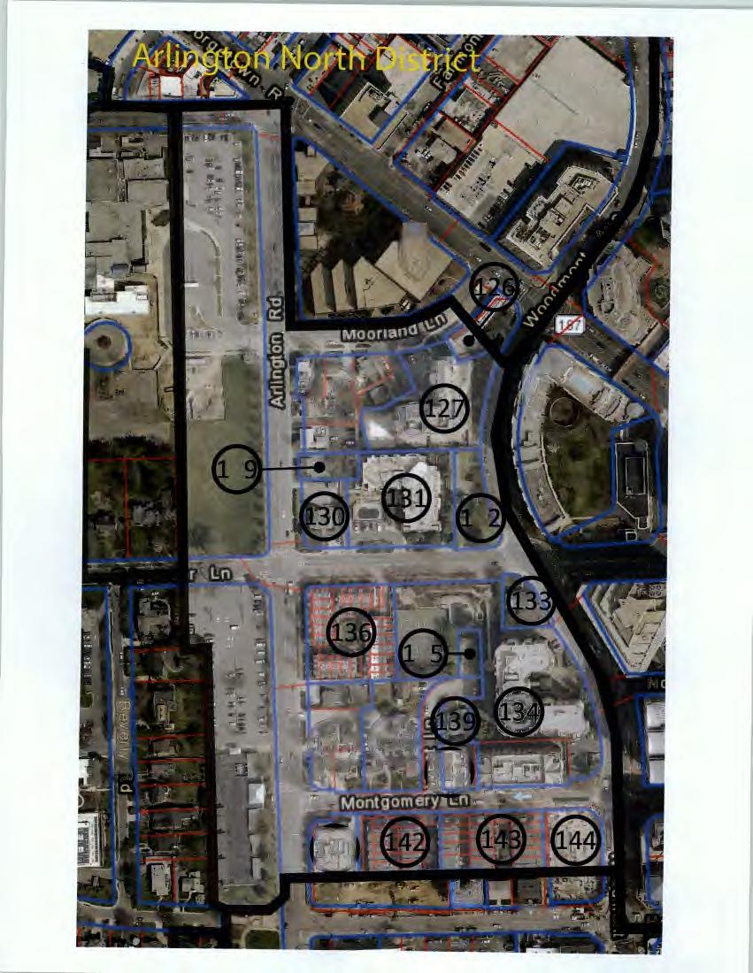

51
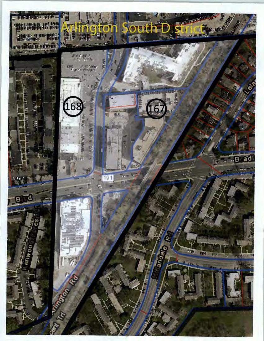

52
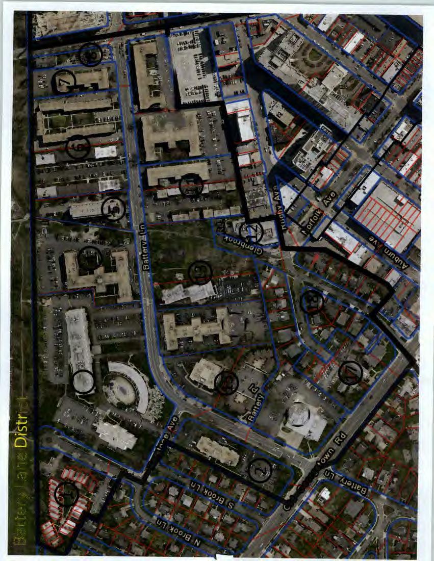

53
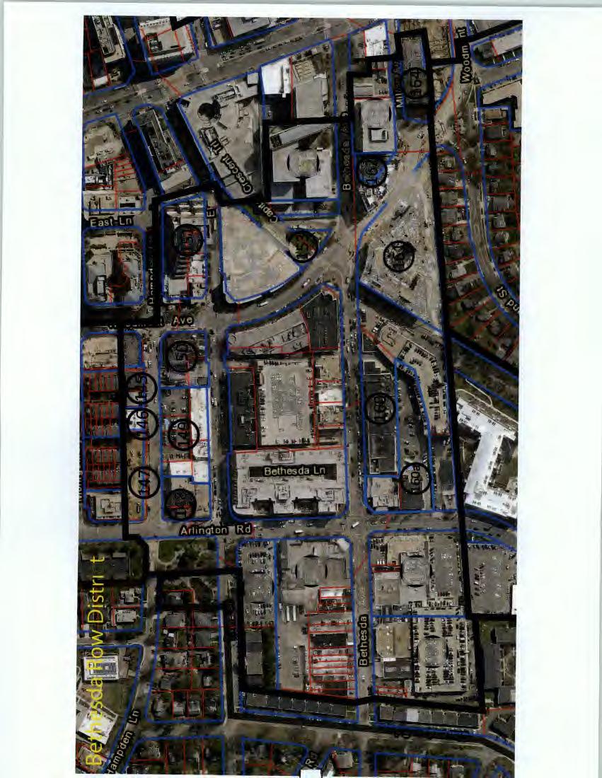
54
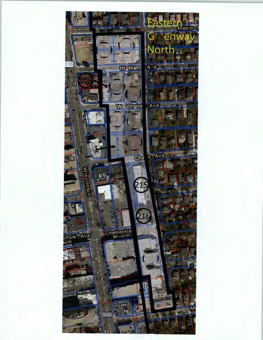
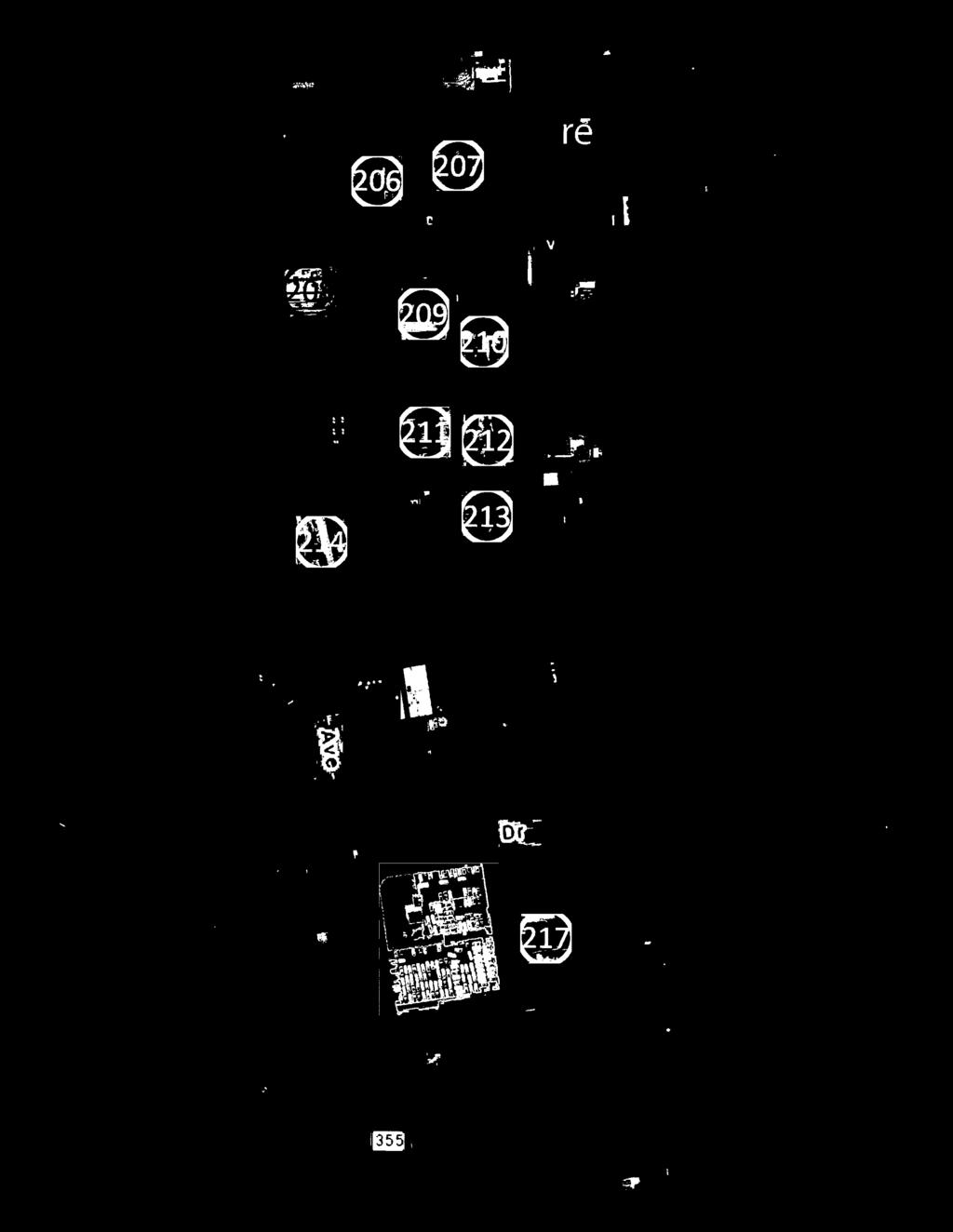
55


56

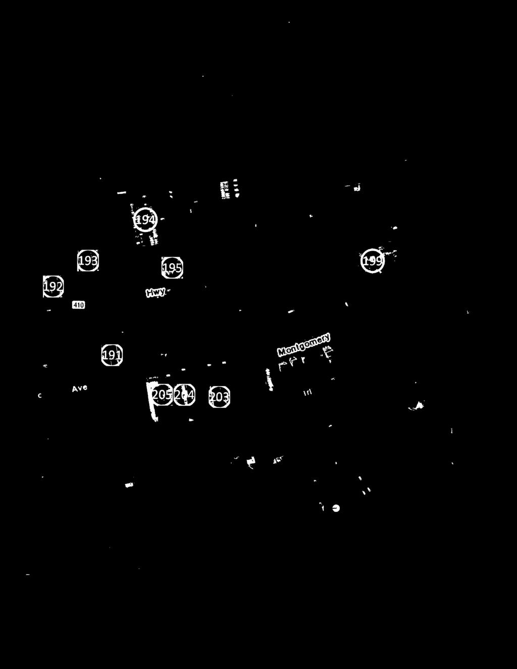
57
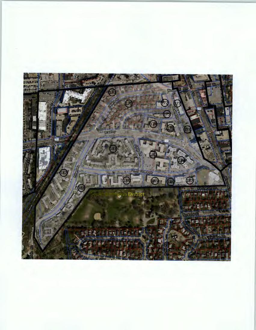

58


59
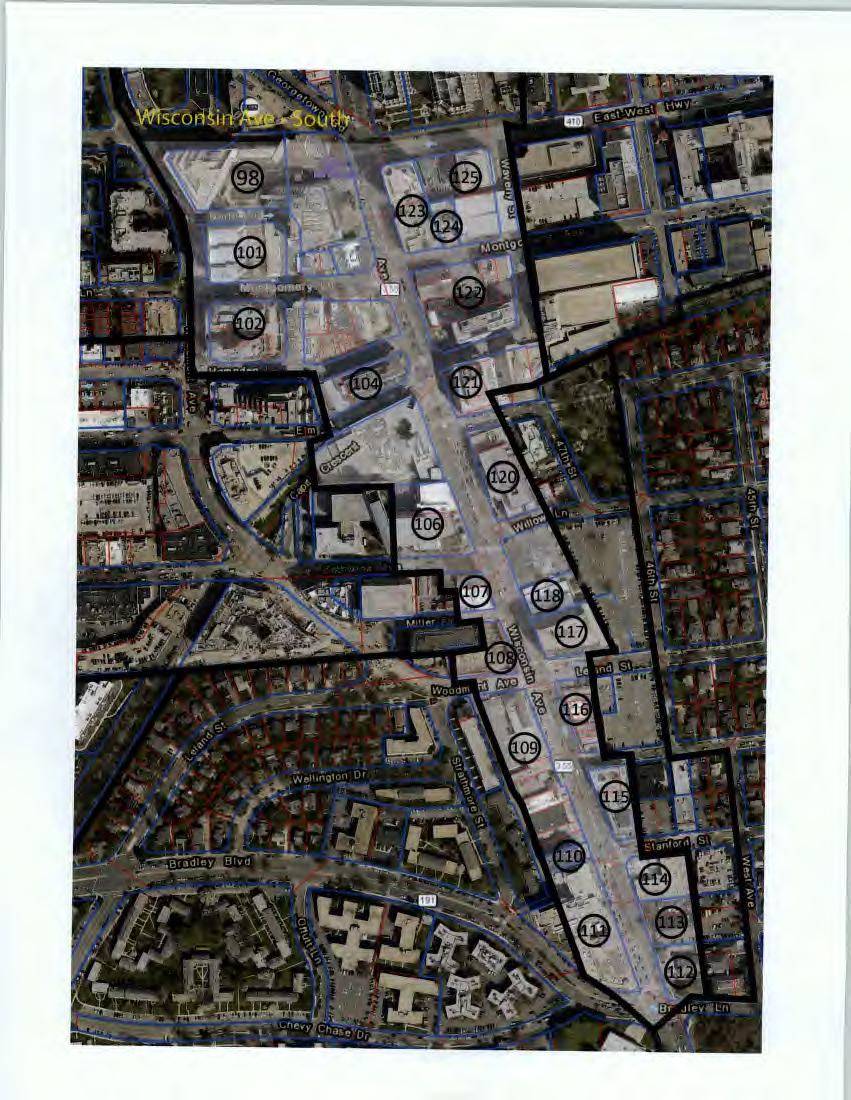

60
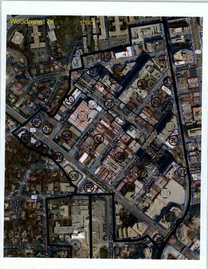


61
MONTGOMERY COUNTY PLANNING DEPARTMENT THE MARYLAND NATIONAL CAPITAL PARK AND PLANNING COMMISSION
 MONTGOMERY COUNTY PLANNING DEPARTMENT THE MARYLAND NATIONAL CAPITAL PARK AND PLANNING COMMISSION Bethesda Downtown Sector Plan, Work Session #1 MCPB Item No. Date: 7-20-15 Leslye Howerton, Planner Coordinator,
At first Work Session on October 22, At second Work Session on November 19, At third Work Session on December 3, 2015
 At first Work Session on October 22, 2015 Staff Reviewed Infrastructure: Transportation Capacity School Capacity Willett Branch Proposed Staging Language At second Work Session on November 19, 2015 Land
Agenda. 3. Outstanding Items. How it would work (DRP) Urban Design Guidelines language in Sector Plan (Concepts) vs. Guidelines Document (Detail)
 Urban Design Guidelines language in Sector Plan (Concepts) vs. Guidelines Document (Detail)") Work Session #14 Planning Board June 9, 2016 Agenda 1. Big Picture Items to Confirm Upfront 2. Detailed Topics for Conversation a) Park Impact Payment b) Priority Sending Sites - Additional Incentives
Work Session #14 Planning Board June 9, 2016 Agenda 1. Big Picture Items to Confirm Upfront 2. Detailed Topics for Conversation a) Park Impact Payment b) Priority Sending Sites - Additional Incentives
S C O P E O F W O R K A P R I L
 white flint 2 sector plan S C O P E O F W O R K A P R I L 2 0 1 2 MONTGOMERY COUNTY PLANNING DEPARTMENT M-NCPPC MontgomeryPlanning.org 1 white flint 2 sector plan Scope of Work abstract This scope of work
MONTGOMERY COUNTY PLANNING DEPARTMENT THE MARYLAND NATIONAL CAPITAL PARK AND PLANNING COMMISSION
 MONTGOMERY COUNTY PLANNING DEPARTMENT THE MARYLAND NATIONAL CAPITAL PARK AND PLANNING COMMISSION Bethesda Downtown Sector Plan, Work Session #8 MCPB Item No.8 Date: 02-25-16 Leslye Howerton, Planner Coordinator,
master plan of highways bus rapid transit amendment
 Scope of Work master plan of highways bus rapid transit amendment September 2011 Montgomery County Planning Department M-NCPPC MontgomeryPlanning.org 1 Scope of Work master plan of highways bus rapid transit
MEMORANDUM BACKGROUND. lcouncilmembers should bring their copy of the Plan to the meeting.i. AGENDA ITEM #l0a November 28, 2017.
 AGENDA ITEM #l0a November 28, 2017 Worksession MEMORANDUM November 22, 2017 TO: FROM: SUBJECT: County Council ~ Marlene Michaelson, Senior Legislative Analyst Grosvenor-Strathmore Metro Area Minor Master
MONTGOMERY COUNTY PLANNING DEPARTMENT THE MARYLAND-NATIONAL CAPITAL PARK AND PLANNING COMMISSION
 MONTGOMERY COUNTY PLANNING DEPARTMENT THE MARYLAND-NATIONAL CAPITAL PARK AND PLANNING COMMISSION MCPB Item No. 6 Date: 7.22.13 Bethesda Purple Line Station Minor Master Plan Amendment, Scope of Work Elza
Status Report: MD 355 Project
 Status Report: MD 355 Project OCTOBER 2006 M-NCPPC MONTGOMERY COUNTY PLANNING DEPARTMENT Summary of Community Comments, and break to the Results of the MD 355 Participation Session Brookside Gardens -
MONTGOMERY COUNTY PLANNING DEPARTMENT THE MARYLAND NATIONAL CAPITAL PARK AND PLANNING COMMISSION
 MONTGOMERY COUNTY PLANNING DEPARTMENT THE MARYLAND NATIONAL CAPITAL PARK AND PLANNING COMMISSION MCPB Item No. Date: 5.3.18 8000 Wisconsin Avenue Sketch Plan No. 320180120 Matthew Folden, Planner Coordinator,
Rock Spring Master Plan Community Meeting #6: Land Use + Transportation Forecasts
 Rock Spring Master Plan Community Meeting #6: Land Use + Transportation Forecasts May 23, 2016 Ι Walter Johnson High School Andrea Gilles, andrea.gilles@montgomeryplanning.org Ι www.montgomeryplanning.org/community/rockspring/
MONTGOMERY COUNTY PLANNING DEPARTMENT THE MARYLAND NATIONAL CAPITAL PARK AND PLANNING COMMISSION
 MONTGOMERY COUNTY PLANNING DEPARTMENT THE MARYLAND NATIONAL CAPITAL PARK AND PLANNING COMMISSION Bethesda Downtown Sector Plan, Work Session #5 MCPB Item No. Date: 12-15-15 Leslye Howerton, Planner Coordinator,
TO: FROM: SUBJECT: Background
 TO: FROM: SUBJECT: Long Range Planning Committee and Zoning Committee of the Planning Commission Kellie Brown and Margaret Rhodes, Planning Division, CPHD DATE: June 8, 2017 Courthouse Square Implementation
The transportation system in a community is an
 7 TRANSPORTATION The transportation system in a community is an important factor contributing to the quality of life of the residents. Without a sound transportation system to bring both goods and patrons
DRAFT. October Wheaton. Design Guidelines
 October 2011 DRAFT Wheaton Design Guidelines 2 Draft - Design Guidelines - Wheaton Sector Plan Contents 04 Section 1: Introduction 06 Section 2: Context 08 Section 3: Design Guidelines 09 Goal 1: Create
THE 355/270 CORRIDOR:
 THE 355/270 CORRIDOR: Strategic Ideas for Sustaining a Livable Work Place Project Summary ACCESS LIFE DESIGN HEALTH WORK Montgomery County Planning Department The Maryland-National Capital Park and Planning
Town Center (part of the Comprehensive Plan)
") Town Center (part of the Comprehensive Plan) Mercer Island Town Center Looking North (2014) In 1994, a year-long process culminated in a set of design guidelines and code requirements for the Town Center
Town Center (part of the Comprehensive Plan) Mercer Island Town Center Looking North (2014) In 1994, a year-long process culminated in a set of design guidelines and code requirements for the Town Center
MEMORANDUM. Resolution Approving the Sandy Spring Rural Village Plan
 AGENDA ITEM #7A February 24,2015 MEMORANDUM February 20, 2015 TO: County Council.{"",,\~ FROM: Marlene Michaelson, Senior Legislative Analyst Tl \ Glenn Orlin, Deputy Council Administrator &0 SUBJECT:
MONTGOMERY COUNTY PLANNING DEPARTMENT
 MONTGOMERY COUNTY PLANNING DEPARTMENT THE MARYLAND-NATIONAL CAPITAL PARK AND PLANNING COMMISSION MCPB Item No.: Date: 5-03-18 Pike and Rose, Phase I: Site Plan Amendment No. 82012002D Rhoda Hersson-Ringskog,
MONTGOMERY COUNTY PLANNING DEPARTMENT THE MARYLAND NATIONAL CAPITAL PARK AND PLANNING COMMISSION
 MONTGOMERY COUNTY PLANNING DEPARTMENT THE MARYLAND NATIONAL CAPITAL PARK AND PLANNING COMMISSION MCPB Item No. 8 Date: 3.30.2017 Project Name: Lot 31/31A Bethesda, Site Plan Amendment, No. 82007018C Elza
JUSTIFICATION STATEMENT FOR SITE PLAN NO Site Plan Justification for Chevy Chase Lake Townhouses
 I. INTRODUCTION JUSTIFICATION STATEMENT FOR SITE PLAN NO. 820150050 Site Plan Justification for Chevy Chase Lake Townhouses Applicant, CC Associates LLC (the Applicant ), by its attorneys, Linowes and
PROJECT NARRATIVE AND JUSTIFICATION STATEMENT
 7000 WISCONSIN AVENUE SKETCH PLAN NO. 320190090 PROJECT NARRATIVE AND JUSTIFICATION STATEMENT I. INTRODUCTION Starr Capital LLC and Woodfield Development Company (collectively, the Applicant ) are the
WOODMONT TRIANGLE AMENDMENT TO THE SECTOR PLAN FOR THE BETHESDA CBD
 APPROVED AND ADOPTED M A R C H 2 0 0 6 WOODMONT TRIANGLE AMENDMENT TO THE SECTOR PLAN FOR THE BETHESDA CBD THE MARYLAND-NATIONAL CAPITAL PARK AND PLANNING COMMISSION 8787 Georgia Avenue, Silver Spring,
Citizen Comment Staff Response Staff Recommended Revision Planning Committee
 Citizen Comment Staff Response Staff Recommended Revision Planning Committee Area No. 1: Owner desires retail land uses. Area No. 1a: Owner of two small parcels adjacent to Area No. 1 desires retail land
ARLINGTON COUNTY, VIRGINIA
 ARLINGTON COUNTY, VIRGINIA County Board Agenda Item Meeting October 15, 2005 DATE: September 28, 2005 SUBJECT: Request to Advertise the adoption of the 2005 Clarendon Sector Plan C. M. RECOMMENDATION:
Review of Opportunity Area C Draft Comprehensive Plan and Draft BOS Follow-On Motions. Special Working Group Meeting March 4, 2015
 Review of Opportunity Area C Draft Comprehensive Plan and Draft BOS Follow-On Motions Special Working Group Meeting March 4, 2015 The slides that follow identify where the draft Comprehensive Plan has
Bethesda. Downtown Plan Design Guidelines. Approved July access + mobility. community identity. habitat + health. equity. water.
 Bethesda Downtown Plan Design Guidelines community identity equity habitat + health access + mobility water energy Approved July 2017 THE MONTGOMERY COUNTY PLANNING DEPARTMENT THE MARYLAND-NATIONAL CAPITAL
Wheaton CBD & Vicinity Sector Plan D E S I G N G U I D E L I N E S
 Wheaton CBD & Vicinity Sector Plan D E S I G N G U I D E L I N E S 1 a b s t r a c t This document contains the design guidelines the property owners, community members, and planners should use to implement
3. VISION AND GOALS. Vision Statement. Goals, Objectives and Policies
 Vision Statement Queen Creek s interconnected network of parks, trails, open spaces and recreation opportunities provide safe and diverse activities and programs that sustain its unique, small town, equestrian
CHARLES PUTMAN CHARLES PUTMAN AND ASSOCIATES, INC
 MEMORANDUM CHARLES PUTMAN & ASSOCIATES, INC. LAND DEVELOPMENT CONSULTANTS PLANNING ZONING PERMITTING 4722 NW Boca Raton Boulevard, Suite C-106 Boca Raton, Florida 33431 Phone: 561/994-6411 FAX: 561/994-0447
Gold Line Bus Rapid Transit Transit Oriented Development (BRTOD) Helmo Station Area Plan
 Helmo Station Area Plan") Appendix F Gold Line Bus Rapid Transit Transit Oriented Development (BRTOD) Helmo Station Area Plan Introduction and Purpose of the Plan The Gold Line Bus Rapid Transit facility is an eleven-mile dedicated
Appendix F Gold Line Bus Rapid Transit Transit Oriented Development (BRTOD) Helmo Station Area Plan Introduction and Purpose of the Plan The Gold Line Bus Rapid Transit facility is an eleven-mile dedicated
County Council Presentation. White Oak Science Gateway Planning Board Draft Master Plan June 17, 2014
 County Council Presentation White Oak Science Gateway Planning Board Draft Master Plan June 17, 2014 http://montgomeryplanning.org/community/wosg/index.shtm Nancy Sturgeon, Lead Planner www.nancy.sturgeon@montgomeryplanning.org
2.7 ac park. TOTAL 5,403 DU 1,297,900 sf 1,105,450 sf 3.87 ac 5,563 DU 1,121,200 sf 1,105,450 sf 3.87 ac
 PLAN AMENDMENT 2013-I-B1: SEVEN CORNERS SPECIAL STUDY Summary of Pre-staffing Comments Planner: Bernard Suchicital bsuchi@fairfaxcounty.gov (703) 324-1254 Background On October 29, 2013, the Board of Supervisors
master plan of highways
 scope of work master plan of highways abstract This Scope of Work outlines the tasks and goals of updating the Master Plan of Highways, as well as the outreach that will be used in the planning process.
At the public hearings in October, numerous Bethesda area residents spoke of their hopes for the Plan, but also of their concerns about:
 January 17, 2017 Honorable Roger Berliner President, Montgomery County Council Stella B. Werner Council Office Building 100 Maryland Ave. Rockville, MD 20850 RE: Bethesda Downtown Plan Dear President Berliner
MONTGOMERY COUNTY PLANNING DEPARTMENT THE MARYLAND-NATIONAL CAPITAL PARK AND PLANNING COMMISSION
 MONTGOMERY COUNTY PLANNING DEPARTMENT THE MARYLAND-NATIONAL CAPITAL PARK AND PLANNING COMMISSION Staff Report: Sketch Plan #320110010, Mid-Pike Plaza ITEM #: MCPB HEARING DATE: January 20, 2011 REPORT
Silver Line CPAM UPDATE. Transportation and Land Use Committee October 14, 2016
 Silver Line CPAM UPDATE Transportation and Land Use Committee October 14, 2016 Purpose Recap Project History and Map Changes Provide Overview of CPAM Components Discuss Transportation Impacts Discuss Fiscal
MONTGOMERY COUNTY PLANNING DEPARTMENT THE MARYLAND-NATIONAL CAPITAL PARK AND PLANNING COMMISSION
 MONTGOMERY COUNTY PLANNING DEPARTMENT THE MARYLAND-NATIONAL CAPITAL PARK AND PLANNING COMMISSION MCPB Item No. Date10/25/12 Sketch Plan No. 32012004, White Flint Mall Redevelopment Nkosi Yearwood, Senior
Bethesda Downtown Plan Annual Monitoring Report. May 2018
 Bethesda Downtown Plan Annual Monitoring Report May 2018 THE MONTGOMERY COUNTY PLANNING DEPARTMENT THE MARYLAND-NATIONAL CAPITAL PARK AND PLANNING COMMISSION Abstract This report meets the 2017 Bethesda
MONTGOMERY COUNTY PLANNING DEPARTMENT THE MARYLAND-NATIONAL CAPITAL PARK AND PLANNING COMMISSION
 MONTGOMERY COUNTY PLANNING DEPARTMENT THE MARYLAND-NATIONAL CAPITAL PARK AND PLANNING COMMISSION MCPB Item No. Date: 05/12/2016 North Bethesda Conference Center Parking Structure, Mandatory Referral No.
ATTACHMENT. To the west, north, and east of the block, primarily singlefamily detached residential patterns, with some townhouses, predominate.
 COMMENT / REVISION MATRIX (as of ) for Washington and Kirkwood Special GLUP Study "Plus" and Concept Plan 1 2 Resolve inconsistency between American Legion site area noted in Map 1 1.36 AC 1.29 AC and
Public input has been an important part of the plan development process.
 Lakewood s Comprehensive Plan recognizes that transportation helps shape the community, and that the way the community provides for the safe and efficient movement of people affects the character of the
EXISTING COMPREHENSIVE PLAN
 EXISTING COMPREHENSIVE PLAN Town Center Land Use Element: V. LAND USE POLICIES Town Center Mercer Island's business district vision as described in "Your Mercer Island Citizen-Designed Downtown" was an
Executive Summary. NY 7 / NY 2 Corridor
 Executive Summary NY 7 / NY 2 Corridor Transportation and Land Use Study December 2005 Prepared for: Town of Colonie Capital District Transportation Committee Prepared by: Introduction: Land use decisions
MONTGOMERY COUNTY PLANNING DEPARTMENT
 MONTGOMERY COUNTY PLANNING DEPARTMENT THE MARYLAND-NATIONAL CAPITAL PARK AND PLANNING COMMISSION MCPB Item No. Date: 04/05/2018 850 Sligo Avenue Sketch Plan No. 320180090 Neil Sullivan, Planner Coordinator,
Date: April 10, 2017 City Council Work Session April 24, 2017: Status Report on the Comprehensive Plan Update and Transportation Master Plan
 AGENDA REPORT To: From: By: Honorable Mayor and City Council Members Warren Hutmacher, City Manager Sharon Ebert, Director Community Development Date: April 10, 2017 Agenda: City Council Work Session April
Bethesda Downtown Plan
 Bethesda Downtown Plan Planning Board Update Connecticut Avenue Location Economic Sustainability Social Environmental Scope Coming Soon! Team Listening, Twitter Outreach We Are Here Engagement Challenge
ELMVALE ACRES SHOPPING CENTRE MASTER PLAN
 ELMVALE ACRES SHOPPING CENTRE MASTER PLAN Contents 1.0 INTRODUCTION... 2 2.0 LOCATION... 2 3.0 EXISTING CONTEXT... 2 4.0 VISION & GUIDING PRINCIPLES... 2 5.0 LAND USE AND BUILT FORM... 4 5.1 St. Laurent
Seneca Meadows. Block 4 Locate office, technology, and medical development adjacent to I Screen views of garage structures from I-270.
 Seneca Meadows Seneca Meadows has an industrial park in its southern end and a mixed-use employment area planned for the north end. The district benefits from extensive I-270 visibility, stream valley
New Partners for Smart Growth Conference February 5, 2010
 Dan Stroh, Planning Director City of Bellevue Planning and Community Development Bellevue, WA New Partners for Smart Growth Conference February 5, 2010 Summary of Project Long-range plan update for Bel-Red
REQUEST Current Zoning: O-15(CD) (office) Proposed Zoning: TOD-M(CD) (transit oriented development mixed-use, conditional)
 (office) Proposed Zoning: TOD-M(CD) (transit oriented development mixed-use, conditional)") Rezoning Petition 2016-117 Zoning Committee Recommendation January 4, 2017 REQUEST Current Zoning: O-15(CD) (office) Proposed Zoning: TOD-M(CD) (transit oriented development mixed-use, conditional) LOCATION
Rezoning Petition 2016-117 Zoning Committee Recommendation January 4, 2017 REQUEST Current Zoning: O-15(CD) (office) Proposed Zoning: TOD-M(CD) (transit oriented development mixed-use, conditional) LOCATION
Preliminary Recommendations Tk Takoma/Langley Crossroads Sector Plan
 Preliminary Recommendations Tk Takoma/Langley Crossroads Sector Plan Vision is to achieve a Transit Oriented, pedestrian friendly Community that Celebrates and builds upon the cultural Diversity of the
CHAPTER 12 IMPLEMENTATION
 CHAPTER 12 IMPLEMENTATION The 2010 Town of Denton Comprehensive Plan is intended to capture a vision of the future of Denton. As such, it provides a basis for a wide variety of public and private actions
CITY OF CHARLOTTESVILLE, VIRGINIA CITY COUNCIL AGENDA
 CITY OF CHARLOTTESVILLE, VIRGINIA CITY COUNCIL AGENDA Agenda Date: December 16, 2013 Action Required: Adoption of Resolution Presenter: Staff Contacts: Title: James E. Tolbert, AICP, Director of NDS James
COMMUNITY DESIGN. GOAL: Create livable and attractive communities. Intent
 COMMUNITY DESIGN Intent An attractive, well-designed County will attract quality development, instill civic pride, improve the visual character of the community, and create a strong, positive image for
Northwest Rail Corridor and US 36 BRT Development Oriented Transit Analysis 4.4 STATION AREA FINDINGS
 4.4 STATION AREA FINDINGS Each station is different, and each one requires a separate set of recommendations based on the vision for the site. This section outlines an initial TOD strategy and recommendations
Planning Board Briefing
 Planning Board Briefing Why Now? The Sector Plan Implementation Chapter States: Before Stage 1 begins, the following must occur: Approval of the Sectional Map Amendment. Approval of the Greater Lyttonsville
Rock Spring Master Plan Community Meeting #8: Preliminary Recommendations
 Rock Spring Master Plan Community Meeting #8: Preliminary Recommendations July 18, 2016 Ι Walter Johnson High School Andrea Gilles, andrea.gilles@montgomeryplanning.org Ι www.montgomeryplanning.org/community/rockspring/
Long Branch Sector Plan
 June 2012 Long Branch is one of Montgomery County s most affordable, older communities and has served as a gateway community, especially for newly arriving immigrants, since the 1960s. Many within this
City of Farmington. Downtown Plan. Amendment to the 1998 Master Plan Adopted October 11, 2004
 City of Farmington Amendment to the 1998 Master Plan Adopted October 11, 2004 Introduction Planning Background 1 Scope and Components of the Plan Amendment 2 Concept Introduction 3 Plan Concepts 3 Conceptual
Staff Report and Recommendation
 Community Planning and Development Planning Services 201 W. Colfax Ave., Dept. 205 Denver, CO 80202 p: 720.865.2915 f: 720.865.3052 www.denvergov.org/cpd TO: City Council Neighborhoods and Planning Committee
LAND USE AMENDMENT DOWNTOWN COMMERCIAL CORE (WARD 7) MACLEOD TRAIL SE AND 5 AVENUE SE BYLAW 254D2017
 MACLEOD TRAIL SE AND 5 AVENUE SE BYLAW 254D2017") Page 1 of 10 EXECUTIVE SUMMARY This Land Use Amendment application seeks to redesignate a full downtown block (currently the YWCA site) from a Direct Control based on the CM-2 District (Land Use Bylaw
Page 1 of 10 EXECUTIVE SUMMARY This Land Use Amendment application seeks to redesignate a full downtown block (currently the YWCA site) from a Direct Control based on the CM-2 District (Land Use Bylaw
Transportation. Strategies for Action
 Transportation A major priority for the Overlake Neighborhood is to develop a multimodal transportation system. To achieve this system, a balance has to be found among travel, circulation and access needs;
Westwood Shopping Center Sketch Plan, Plan # February 23, 2017 Item # 9
 Westwood Shopping Center Sketch Plan, Plan # 320170010 February 23, 2017 Item # 9 Westwood II Site 64,111 s.f. Manor Care site: vacant two story building HOC-Westwood Towers, 15 story tower To be considered
MONTGOMERY COUNTY PLANNING DEPARTMENT THE MARYLAND-NATIONAL CAPITAL PARK AND PLANNING COMMISSION
 MONTGOMERY COUNTY PLANNING DEPARTMENT THE MARYLAND-NATIONAL CAPITAL PARK AND PLANNING COMMISSION MCPB Item No. Date: 1/15/2015 Bethesda North Marriott Hotel and Conference Center: Limited Site Plan Amendment
DRAFT PLAN PRESENTATION
 DRAFT PLAN PRESENTATION 1.23.2018 AGENDA Process Project Schedule Results from Visioning Workshop Draft Plan Highlights Concept Plans Feedback Next Steps PROJECT SCHEDULE KICK-OFF WORKSHOP August 29 th
MONTGOMERY COUNTY PLANNING DEPARTMENT THE MARYLAND-NATIONAL CAPITAL PARK AND PLANNING COMMISSION
 MONTGOMERY COUNTY PLANNING DEPARTMENT THE MARYLAND-NATIONAL CAPITAL PARK AND PLANNING COMMISSION Long Branch Sector Plan, Worksession 5 MCPB Item No. Date: 4.11.13 Melissa Williams, Senior Planner, Area
4 Bethesda Metro Center, Bethesda, Maryland Statement of Justification Sketch Plan
 I. Introduction 4 Bethesda Metro Center, Bethesda, Maryland Statement of Justification Sketch Plan BOP Bethesda Metro Center LLC, an affiliate of Brookfield Property Partners (the "Applicant") is submitting
Pedestrian and Bike Bridge LOGO
 6.2.2 Pedestrian and Bike Bridge The proposed pedestrian and bike crossing re-envisions the existing bridge at Pismo Creek on Cypress Street. The bridge is currently underutilized by vehicular through
Description. Summary. MCPB Item No. Date: 01/17/13. Bethesda Crescent, Limited Site Plan Amendment, A, A
 THE MARYLAND-NATIONAL CAPITAL PARK AND PLANNING COMMISSION MCPB Item No. Date: 01/17/13 Bethesda Crescent, Limited Site Plan Amendment, 81984005A, 81984003A Parag Agrawal, Senior Planner, parag.agrawal@montgomeryplanning.org,
TREASURE COAST REGIONAL PLANNING COUNCIL M E M O R A N D U M. To: Council Members AGENDA ITEM 5H
 TREASURE COAST REGIONAL PLANNING COUNCIL M E M O R A N D U M To: Council Members AGENDA ITEM 5H From: Date: Subject: Staff October 17, 2008 Council Meeting Local Government Comprehensive Plan Review Draft
Proposed Comprehensive Plan Strategies DRAFT for discussion June 28, 2017
 Proposed Comprehensive Plan Strategies DRAFT for discussion June 28, 2017 Land Use Rural Areas Refine the Farm and Forest area (FF) Update FF boundaries to account for existing lots less than five acres
ARLINGTON COUNTY, VIRGINIA. County Board Agenda Item Meeting of February 23, 2019
 ARLINGTON COUNTY, VIRGINIA County Board Agenda Item Meeting of February 23, 2019 DATE: February 15, 2019 SUBJECT: Amendment to the Master Transportation Plan (MTP) Map to add a new section of North Kansas
MONTGOMERY COUNTY PLANNING DEPARTMENT THE MARYLAND-NATIONAL CAPITAL PARK AND PLANNING COMMISSION
 MONTGOMERY COUNTY PLANNING DEPARTMENT THE MARYLAND-NATIONAL CAPITAL PARK AND PLANNING COMMISSION MCPB Item No. 2 Date: 2.8.2018 7359 Wisconsin Avenue: Sketch Plan No. 320180070, Preliminary Plan No. 120180040,
RESOLUTION NO. R Refining the route, profile and stations for the Downtown Redmond Link Extension
 RESOLUTION NO. R2018-32 Refining the route, profile and stations for the Downtown Redmond Link Extension MEETING: DATE: TYPE OF ACTION: STAFF CONTACT: Capital Committee Board PROPOSED ACTION 09/13/2018
MONTGOMERY COUNTY PLANNING DEPARTMENT THE MARYLAND NATIONAL CAPITAL PARK AND PLANNING COMMISSION
 MONTGOMERY COUNTY PLANNING DEPARTMENT THE MARYLAND NATIONAL CAPITAL PARK AND PLANNING COMMISSION MCPB Item No. 3 Date: 1.5.17 7272 Wisconsin Avenue: Sketch Plan Amendment No. 32016004A, Preliminary Plan
TRANSPORTATION ELEMENT GOALS, OBJECTIVES, AND POLICIES
 TRANSPORTATION ELEMENT GOALS, OBJECTIVES, AND POLICIES GOAL 2 The City shall provide a safe, convenient, effective, and energy efficient multimodal transportation system which is coordinated with the Future
S A C R A M E N T O C O U N T Y JACKSON HIGHWAY & GRANT LINE EAST VISIONING STUDY
 JACKSON HIGHWAY & GRANT LINE EAST S A C R A M E N T O C O U N T Y P L A N N I N G D E P A R T M E N T SUMMARY AND WORKBOOK November 19, 2008 History of the Visioning Study Sacramento County has two growth
Community Meeting November 18, 2015
 Top Concerns We ve Heard Use of Urban Road Code Total number of units and effect on schools and transportation Land swaps with Parks Department: how do these benefit the community? Zoning classifications:
Town Center. Block 5 Existing multifamily residential units are expected to remain.
 Area Guidelines Germantown s districts should be developed as distinct communities with unique features that are supported through the guidelines. The guidelines not only help distinguish these districts
Chapter 1.0 Introduction
 Chapter 1.0 Introduction 1.1 Background The North Metro commuter rail line is part of the RTD FasTracks regional transit system expansion program to build more than 100 miles of rail transit throughout
South Davis County COMMUNITY SPOTLIGHT
 South Davis County COMMUNITY SPOTLIGHT Davis/SLC Community Connector Bus Rapid Transit line connecting SLC & Davis County RTP Phase 1 Project Generate 3,100 average weekday riders Relieve congestion on
Issues Requiring Future Study
 Issues Requiring Future Study Transportation planning is an ongoing process that tends to identify new issues as it finds solutions for others. Some issues are so complex that a solution to one problem
SDOT DPD. SDOT Director s Rule DPD Director s Rule DCLU DR SED DR of 7 CITY OF SEATTLE
 SDOT SDOT Director s Rule 2-07 DPD Applicant: CITY OF SEATTLE Page 1 of 7 Supersedes: DCLU DR 11-93 SED DR 93-4 Seattle Department of Transportation (SDOT) Department of Planning and Development (DPD)
ARTICLE 6: Special and Planned Development Districts
 ARTICLE 6: Special and Planned Development Districts 6-10 Traditional Neighborhood Development (TND) District 6-10.10 Purpose and Intent The Traditional Neighborhood Development (TND) District provides
Courthouse Square Implementation Comment/Response Matrix
 Courthouse Square Implementation /Response Matrix 1 Are open space symbols binding? GLUP No, open space symbols are not binding, as the GLUP is a policy instrument illustrating the County s future vision
ASPEN HILL Minor Master Plan Amendment
 ASPEN HILL Minor Master Plan Amendment Project Briefing Planning Board Agenda Item #7 Andrea Gilles, Area 2 June 5, 2014 Briefing Purpose 1. Follow-up evaluation on Mixed-Use land use in the Minor Amendment
Draft Memorandum #1: Goals and Vision for Revitalization
 Keizer Revitalization Plan Draft Memorandum #1: Goals and Vision for Revitalization Submitted to: City of Keizer April 12, 2018 (revised) Prepared By: Angelo Planning Group and Otak, Inc. Project No. 17482.A
Courthouse Square Planning & Urban Design Study Working Group Meeting #11 September 2, 2014
 Courthouse Square Planning & Urban Design Study Working Group Meeting #11 September 2, 2014 1 Study Area Courthouse Square DRAFT Design Concepts A B C 3 Public Feedback July 23 Workshop & Online Survey
SUBJECT: Waterfront Hotel Planning Study Update TO: Planning and Development Committee FROM: Department of City Building. Recommendation: Purpose:
 Page 1 of Report PB-23-18 SUBJECT: Waterfront Hotel Planning Study Update TO: Planning and Development Committee FROM: Department of City Building Report Number: PB-23-18 Wards Affected: 2 File Numbers:
A. WHAT IS A GENERAL PLAN?
 I. Introduction A. WHAT IS A GENERAL PLAN? A general plan is the planning guideline for the future of a city. It contains goals and policies which regulate urban development, the protection of the natural
Urban Planning and Land Use
 Urban Planning and Land Use 701 North 7 th Street, Room 423 Phone: (913) 573-5750 Kansas City, Kansas 66101 Fax: (913) 573-5796 Email: planninginfo@wycokck.org www.wycokck.org/planning To: From: City Planning
PLAN ELEMENTS WORKSHOP. April 5, 2016
 PLAN ELEMENTS WORKSHOP April 5, 2016 needs more housing. But there is no one-size fits-all solution. Every neighborhood has its own character. In some places, density is not only appropriate it is badly
Transit-Oriented Mixed Use Zoning in Montgomery County, Maryland
 Transit-Oriented Mixed Use Zoning in Montgomery County, Maryland Nkosi Yearwood Community-Based Planning Division Montgomery County Planning Department Rail Volution 2007 Miami, Florida The General Plan
Welcome. Comprehensive Plan & Transportation Plan Open House November 7, 2012
 Welcome Comprehensive Plan & Transportation Plan Open House November 7, 2012 Agenda Proposed future land use plan Comprehensive Plan strategies Traffic forecasts Future traffic operations Possible future
PLANNING COMMISSION WORKSESSION AGENDA. City Hall Second Floor Conference Room 9027 Center Street. July 1, :30 PM
 MEMBERS Harry J. Clark, Chairperson Bruce Wood, Vice-Chairperson Russell Harrison Ken Johnson Robert W. Schilpp Martha Wilson PLANNING COMMISSION WORKSESSION AGENDA City Hall Second Floor Conference Room
MONTGOMERY COUNTY PLANNING DEPARTMENT THE MARYLAND-NATIONAL CAPITAL PARK AND PLANNING COMMISSION
 MONTGOMERY COUNTY PLANNING DEPARTMENT THE MARYLAND-NATIONAL CAPITAL PARK AND PLANNING COMMISSION MCPB Item No. 6 Date: 5-9-13 Site Plan No. 820130090, West Chevy Chase Heights Erin Grayson, Senior Planner,
Today Land & People. Northeast Nampa Gateway District. Employment. Land Use Characteristics. Demographics. Current Zoning
 Today Land & People Employment Major employers include Saint Alphonsus, the College of Western Idaho, the Auto Mall, Sorrento Lactalis and Walmart. 3,004 jobs in 2010 (COMPASS-CIM 2040 TAZ data) 4,345
MONTGOMERY COUNTY PLANNING DEPARTMENT THE MARYLAND-NATIONAL CAPITAL PARK AND PLANNING COMMISSION
 MONTGOMERY COUNTY PLANNING DEPARTMENT THE MARYLAND-NATIONAL CAPITAL PARK AND PLANNING COMMISSION MCPB Item No. Date: 1/26/12 Hanover Shady Grove, Sketch Plan 320120020 Joshua Sloan, Coordinator, Joshua.Sloan@MontgomeryPlanning.org,
CONTENTS BACKGROUND AND CONTEXT... 3 Plan Area... 3 History... 3 Previous Planning Initiatives... 4 PLANNING FRAMEWORK... 5 Countywide Transit
 CONTENTS BACKGROUND AND CONTEXT... 3 Plan Area... 3 History... 3 Previous Planning Initiatives... 4 PLANNING FRAMEWORK... 5 Countywide Transit Corridors Functional Master Plan... 5 Veirs Mill Road Bus