VIRGINIA DRIVE SPECIAL PLAN
|
|
|
- Eugene Lawson
- 5 years ago
- Views:
Transcription

1 August 15, 2017 Staff Report to the Municipal Planning Board CASE #GMP & LDC Item # 7 VIRGINIA DRIVE SPECIAL PLAN Location Map Subject Site SUMMARY Applicant City of Orlando, Planning Office Project Planner Michelle Beamon Robinson, AICP Updated: July 20, 2017 Property Location: The subject property 6. Add two Future Land Use Policies S.13.8 is generally located south of Princeton Aveand S nue, north of Weber Street, east of Orange Avenue and west of Mills Avenue. Staff s Recommendation: (± 103 acres, District 3). Approval of the requests. Applicant s Request: 1. Amend Chapter 62 of the Land Development Code to add the Virginia Drive Special Plan as Section Amend the map in LDC Section , the North Orange Avenue Special Plan. 3. Amend Future Land Use Policy S Amend Future Land Use Figure LU-2 Part C 5. Amend the boundary of Future Land Use Policy S Public Comment Three community meetings were held the Virginia Drive/Lake Highland Transportation and Land Use Study; the meetings were held on August 1, 2016, September 20, 2016 and October 26, The study was approved by the Municipal Planning Board on February 21, 2017.
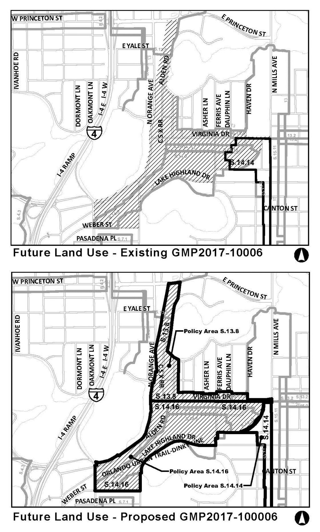
2 Page 2 Project Analysis Project Description The subject property is generally located south of Princeton Avenue, north of Weber Street, east of Orange Avenue and west of Mills Avenue and is approximately 103 acres. The property is within City Council District 3, which is represented by City Commissioner Robert F. Stuart. The City is requesting a new special plan for the Virginia Drive area in conjunction with the Virginia Drive/Lake Highland Transportation and Land Use Study which was approved by the Municipal Planning Board on February 21, The request is to: 1. Amend Chapter 62 of the Land Development Code to add the Virginia Drive Special Plan as Section Amend the map in LDC Section , the North Orange Avenue Special Plan boundary. 3. Amend Future Land Use Policy S Amend Future Land Use Figure LU-2 Part C. 5. Amend the boundary of Future Land Use Policy S Add two Future Land Use Policies S.13.8 and S Background This proposed GMP and LDC amendments are in conjunction with the Virginia Drive/Lake Highland Transportation and Land Use study. Three community meetings were held to uncover the community s shared values; the meetings were held on August 1, 2016, September 20, 2016 and October 26, The Virginia Drive/Lake Highland Special Plan is intended to achieve the following objectives: Establish rights-of-way needed for the following roadways; Virginia Drive, Brookhaven Drive and Alden Road Establish certain cross section criteria for the following roadways; Virginia Drive, Brookhaven Drive, Lake Highland Road and Alden Road. Establish a review requirement for the pedestrian underpass. Establish urban design principles that will be utilized during the appearance review process. Consistency with 163, Florida Statutes The proposed GMP amendments are being processed as a large scale amendment to the Official Future Land Use Map in accordance with the requirements of Chapter (3), Florida Statutes. As provided in Chapter 163, large scale amendments require two public hearings before City Council and are subject to an expedited state review process by the State Department of Economic Opportunity Division of Community Planning and other regional agencies. This amendment is an out of cycle amendment. Conformance with the GMP Subarea Policies S.13.4 and S.14.5 Portions of the study area are within Subarea Policies S.13.4 and S Subarea Policy S.13.4 The subject property is part of the Mills Avenue and Colonial Drive Urban Design and Strategic Plan which was completed in The Virginia Drive /Lake Highland Transportation and Land Use Study is the updated plan for this area. Regardless, this site is consistent with this policy which is described below. Policy S.13.4 All development in this area shall be consistent with the recommendations and guidelines of the Mills Avenue and Colonial Drive Urban Design and Strategic Plan. This LDC amendment is consistent with this subarea policy. The properties that are within this subarea policy are within the Mills/Virginia Focus area within the Mills Avenue and Colonial Drive Urban Design and Strategic Plan, the applicable sections are below. 5. Dinky Line Trail Trail located parallel to Haven Drive, forming a green adjacent to neighborhood and buffering the redevelopment of the Mills Nebraska Lumber site. Boardwalk across Lake Formosa provides public access to lake. Potential easement to provide connection to Wilfred/Lang Triangle park. 6. Virginia Drive Streetscape City to explore opportunities to moderate vehicle speeds, provide parking lanes, determine feasibility of continuous wider sidewalks and evaluate bicycle connections to and through the corridor.
3 Page 3 Potential elimination of on-street parking to accommodate bicycle lanes and/or wider sidewalks and street trees. The Dinky Line Trail improvements have been completed and the Virginia Drive Streetscape and Virginia Drive cross section are addressed within this LDC amendment. Subarea Policy S.14.5 Subarea Policy S.14.5 is for the OUC/Lake Highland Development Plan. This property is located at 1020 Highland Drive, 567 Lake Highland Drive and 500 Brookhaven Drive. Currently 1020 Highland Drive is vacant, and 567 Lake Highland Drive and 500 Brookhaven Drive are developed with a surface parking lot and the Lake Highland Prep sports fields. The purpose of this subarea policy is to guide the redevelopment of this site, which shall be developed as an urban, mixed-use, pedestrian and transit-accommodating infill/redevelopment project that embraces the best practices of sustainable development and Traditional Neighborhood Design (TND). The development program is a maximum of 91 dwelling units (max. density of 16 du/ac), 65,000 sq. ft. of commercial use, and 30,000 sq. ft. of office use (max. intensity of 0.3 FAR). This LDC amendment is consistent with this subarea policy. Upon redevelopment of this site, this subarea policy and this LDC amendment will be required to be met. P R OPOSED GMP A MENDMENTS GMP Amendments Future Land Use Subarea Policy S.14.13, S and Future Land Use Figure LU-2 Part C are proposed to be amended and Future Land Use Subarea Policies S.13.8 and S are proposed to be created with this application. The amendments are described below. Future Land Use Figure LU-2 Part C. Future Land Use Figure LU-2 Part C is proposed to be amended to move the subarea boundary of 7 and 14. This change is shown on page 12 of this staff report. Subarea Policy S This policy is proposed to be amended to reflect the new Virginia Drive/Lake Highland Transportation and Land Use Study. The amendments are listed below in strikethrough/underline format. Policy S The area within the boundaries of this Subarea Policy has been identified as an area of transition from a historically industrial enclave to a more diversified, mixed use, urban infill redevelopment area. In order to implement the Alden Road, Brookhaven Drive, North Orange Avenue, and Virginia Drive Urban Design Plan (2001) and the Virginia Drive/Lake Highland Transportation and Land Use Study (2017), promote redevelopment and increase compatibility with the surrounding Park Lake/Highland and Lake Formosa neighborhoods, the following regulations shall apply: a. Existing industrial uses on property zoned I-G/t may be continued or substituted with other industrial uses allowed in the I-G/t zoning district, but shall not be expanded. Any redevelopment on property zoned I-G/t shall conform to the uses, densities and intensities allowed under the Mixed Use Corridor Medium Intensity future land use designation. Prior to redevelopment, the owners of the property zoned I-G/t shall request a Growth Management Plan amendment and rezoning to assign a Mixed Use Corridor Medium Intensity future land use designation and associated MU-1/t or PD/t zoning. b. In order to encourage mixed residential, office and cultural arts related uses (i.e., indoor theatre, galleries, craft studios, etc.) in this area, the City shall provide the following incentives: i. Application fees shall be waived for GMP Amendments that assign a Mixed Use Corridor-Medium Intensity future land use designation and for an associated rezoning of MU-1/t or PD/t, consistent with the Alden Road, Brookhaven Drive, North Orange Avenue, and Virginia Drive Urban Design Plan. Platting fees shall also be waived.
4 Page 4 4 ii. Vacant Land, Land Use Compatibility and Transportation Study requirements shall be waived for GMP Amendments that assign a Mixed Use Corridor- Medium Intensity future land use designation. c. In order to protect the nearby Park Lake/Highland and Lake Formosa neighborhoods from incompatible uses, the following uses shall be prohibited on property within the Mixed Use Corridor-Medium Intensity future land use designation: iii. Parking/Principal Use i. Intensive Retail ii. Automotive Service d. When the properties along Brookhaven Drive redevelop, the redevelopment must follow the Virginia Drive/Lake Highland Transportation and Land Use Study. Brookhaven Drive is envisioned as a low speed street to provide primary access to larger projects, transit routes, residential development and parking areas. The improvements shall include on street parking, wider sidewalk on the north side, street trees and streetscape amenities. under the Mixed Use Corridor-Medium Intensity future land use designation, the property owner shall contribute to a Street Tree Fund for any new development, substantial enlargement or substantial improvement in accordance with the procedures established in Section 61 of the Land Development Code. This contribution shall fulfill the requirements for any new street trees required under Section 60 of the Land Development Code and ensure the timely implementation of streetscape improvements along Brookhaven Drive. Subarea Policy S The S subarea policy boundary is proposed to be amended to remove the area that is within the new Virginia Drive/Lake Highland Transportation and Land Use Study. The subarea policy map is show on page 5 of this staff report. Subarea Policy S.13.8 A new subarea policy is needed to encompass the subject property. The proposed subarea policy map is show on page 5 of this staff report. The proposed text for the new Subarea Policy 13.8 is as follows: Subarea Policy S.13.8 All development in this area shall be consistent with the recommendations and guide lines of the Virginia Drive/Lake Highland Transportation and Land Use Study. Subarea Policy S A new subarea policy is needed to encompass the subject property. The proposed subarea policy map is show on page 5 of this staff report. The proposed text for the new Subarea Policy is as follows: Subarea Policy S All development in this area shall be consistent with the recommendations and guide lines of the Virginia Drive/Lake Highland Transportation and Land Use Study.
5 Page 5 5
6 Page 6 6 P R OPOSED LDC A MENDMENTS Proposed LDC Amendments The subject property has a mixture of land uses; MU-1/T, I-G/T, PD/T, AC-3A/T, MU-2/T, MU-2/T/SP, AC-N/T and P/T. This amendment will amend these zoning districts to add SP for the new Virginia Drive Special Plan. A portion of the property that is currently zoned SP is being rezoned from the North Orange Avenue Special Plan LDC Section to the Virginia Drive Special Plan. This change is displayed on the map on page 10 of this staff report. P R OPOSED SPECIAL PLAN OVERLAY Proposed Special Plan Overlay The proposed Special Plan Overlay is listed below and the associated map is located on page 9 of this staff report. Section Virginia Drive Special Plan (a) Relationship to the Growth Management Plan. The Growth Management Plan (GMP) calls for an Urban Design Plan for the Virginia Drive corridor (Urban Design Objective 1.4 and Policy 1.4.2), performance standards for mixed-use corridors in the Traditional City (Urban Design Element Goal 2, Objective 2.1, and Goal 4, Objective 4.1, and Policy 4.1.1), encourages redevelopment in this corridor (Future Land Use Policy S.14.13), and has standards for complete streets (Transportation Objectives 1.33 through 1.36 and associated policies). This Special Plan implements the recommendations from the Urban Design Plan and establishes performance standards. (b) Support Document. The Virginia Drive Special Plan implements the Virginia Drive/Lake Highland Transportation Study, which was completed in The purpose of this study was to develop a multimodal transportation network that supports the community s vision of sustainability, vitality, mobility, and safety within the corridor, promotes responsible development and re-use and provides a framework that encourages economic investment. The study outlines strategies to improve the study area in terms of pedestrian, bicycle, transit, roadway, infrastructure and aesthetic projects. (c) Objectives. The overall purpose of the Virginia Drive Special Plan is to strategically guide transportation improvements and development activities to preserve and strengthen the historic, cultural and social character of the Virginia/ Lake Highland area. The specific objectives of this Special Plan are to: 1. Establish rights of-way needed for the following roadways: Virginia Drive, Brookhaven Drive and Alden Road. 2. Establish certain cross section criteria for the following roadways: Virginia Drive, Brookhaven Drive, Lake Highland Road and Alden Road. 3. Establish a review requirement for a proposed pedestrian underpass. 4. Establish urban design principles for redevelopment and new development of properties within the overlay area. (d) Review Process. All properties undergoing site and external building improvements, substantial improvement, substantial enlargement, or redevelopment are subject to this special plan overlay. Existing legally non-conforming uses, buildings or sites are not required to meet this special plan until the property undergoes redevelopment, subject to this review process. Review for compliance with the overlay must be accomplished through one of the following procedures: 1. Master plan pursuant to Chapter 65, Part 2H. 2. Where a master plan is not required, the applicant must submit a request for a Final Site Plan Approval by the Planning Official by way of a determination application. 3. Appearance Review by the Planning Official through a determination application. No building permit shall be issued until this review process has been completed. (e) Complete Streets. This Special Plan implements the complete streets concept, which is an approach that encourages roadways to be planned, designed, operated, and maintained to enable safe, convenient and comfortable travel and access for users of all ages and abilities regardless of their mode of transportation, be it walking, bicycling, driving or
7 Page 7 7 riding public transportation. The roadway improvements listed below will help balance travel modes, prioritize routes and accommodate expected growth. 1. Rights-of-Way and Easement Requirements. Projects with frontage along the following roads must be evaluated with each project to determine if any additional right of way or easements are required. Below are the final roadway widths for planning purposes. a. Virginia Drive width shall be 72 total width or 36 from the centerline to the property line. b. Brook Haven Drive width shall be 60 total width or 30 from the centerline to the property line. c. Alden Road width shall be 72 total width or 36 from the centerline to the property line. d. Alden Road is proposed for realignment. Properties with frontage along Alden Road from Princeton Street to Magnolia Avenue must be evaluated for right of way needs. 2. Cross Section Criteria. The City s vision is to create complete streets for Virginia Drive, Brookhaven Drive, Lake Highland Drive, Alden Road, and Orange Ave. This will be accomplished through a combination of City-initiated capital improvement projects and participation by property owners proportionate to the scope of their redevelopment plans. Each redevelopment project will be evaluated to identify the type and location of required improvements. a. All street frontages must adhere to the City s policy on Complete Streets and include dedicated space for pedestrians, bicyclists, and motor vehicles. On-street parking and appropriate landscaping must also be included. The specific configuration of all 5 of these elements within the available right-of-way will be determined as part of the final engineering and design for the street improvements. b. Virginia Drive is envisioned with an active public realm for all transportation modes. i. Interim improvements (within existing right of way) shall include wider sidewalks, improved landscaping and street trees, sharrows or other interim bicycle improvements, and onstreet parking where feasible. ii. Final improvements (based on final right of way width) shall include dedicated space for bicycles (such as mutiuse path, bike lanes, buffered bike lanes or a cycle track), green parkway, on street parking, wide sidewalks, street trees, streetscape amenities, and underground utilities. iii. Limited or no vehicular access to projects that front Virginia Drive. c. Brookhaven Drive is envisioned as a low speed street to provide primary access to larger projects, transit routes, residential development and parking areas. The improvements shall include on street parking, wider sidewalk on the north side, street trees and streetscape amenities. d. Lake Highland Drive is envisioned as a low speed street that balances vehicular, pedestrian and bicycle access and provides connections to destinations both within and outside the study area. Improvements shall include on street parking, bulb outs in place of striped pavement, street trees, and a sidewalk on the south side of the road. 3. Pedestrian/Cyclist Underpass a. A pedestrian and cyclist underpass under the railroad tracks at E. New Hampshire Street is desired by the City. b. As part of any redevelopment proposal on Alden Road at New Hampshire should be evaluated for potential to preserve ROW for a future underpass. (f) Permitted and Prohibited Uses. In order to encourage redevelopment in accordance with the vision for this area, the following restrictions and changes to allowable uses are required. 1. The following uses are prohibited on property within the Mixed Use Corridor Medium Intensity future land use designation: parking/principal use, intensive retail and automotive service. 2. Commercial uses are required on the street level along Orange Avenue. If office uses expand into this area, mixed use buildings should be designed with offices and/or residential uses above commercial. 3. In the I-G/T zoning district, industrial uses may be substituted within the same building. No existing industrial use shall be expanded. No industrial use shall be established in a new building, or in a building previously used for non-industrial purposes. (g) Industrial Rezoning. I-G/T property must be rezoned to MU-1/T or PD/T. Application fees shall be waived for the GMP amendment, zoning amendment and plat applications provided the proposal is consistent with this Special Plan. (h) Infrastructure Needs. Projects resulting in increased density or intensity shall be evaluated to determine if a transportation study or sanitary sewer infrastructure study is required. (i) Height Limits. All buildings are subject to the maximum height in the zoning district. In addition, for buildings facing
8 Page 8 8 the following locations, the following height limits apply. If requirements conflict, the more restrictive height limit is applicable. 1. Alden Road: 7 stories 2. Virginia Drive: 5 stories 3. Orange Avenue: 5 stories 4. Orlando Urban Trail: 3 stories Nothing shall preclude the master plan or Planning Official review from providing building height transitions and massing projects appropriately. (j) Design Standards. All new site and external building improvements requires an Appearance Review. These urban design standards will be utilized during the appearance review process. A site is expected to meet the urban design principals to the extent feasible. 1. Buildings on Virginia Drive and Brookhaven Drive shall front the street with parking in the rear. 2. Sites shall provide cross access to adjacent sites and shared parking where feasible. 3. Sites adjacent to the Orlando Urban Trail shall provide pedestrian connections from the site to the Orlando Urban Trail. Fencing shall be CPTED style fencing, not privacy fencing. The lighting shall be pedestrian in scale. Lighting for the trail is encouraged, and an exception to Section (a) of the City s lighting code may be approved to provide offsite illumination that serves the trail. 4. Site plans should incorporate a gridded street network with short block lengths, consistent lot sizes, a unified urban form along street frontages, and pedestrian connections that break up long blocks and building masses. 5. Buildings should maintain clear design themes, consistent use of materials, styling and design details. 6. Scale, massing and architectural style of infill buildings should respect the context of the location and should avoid abrupt discrepancies in scale and height to provide transitions to the surrounding neighborhood.

9 P Paaggee9 9 Vi r gi ni a Dr i ve S p ec ia l Pl a n

10 Page North Orange Ave Special Plan Amendment

11 Page Figure LU-2 Part C Amendment
12 Page Findings In review of the proposed LDC amendment, it is found that: 1. The proposed Future Land Use Subarea Policy amendment and Land Development Code amendment are consistent with State Comprehensive Plan (Chapter 187, Florida Statutes). 2. The proposed Future Land Use Subarea Policy amendment and Land Development Code amendment are consistent with the East Central Florida Strategic Policy Plan. 3. The proposed Future Land Use Subarea Policy amendment and Land Development Code amendment are consistent with the provisions of Chapter 163, Part II, Florida Statutes. 4. The proposed Future Land Use Subarea Policy amendment and Land Development Code amendment are consistent with the objectives and policies of the City s adopted Growth Management Plan (GMP); particularly Policy S.13.4 and S The proposed Future Land Use Subarea Policy amendment and the Land Development Code amendment are consistent with the purpose and intent of the requirements of the Land Development Code. 6. The proposed Future Land Use Subarea Policy amendment and the Land Development Code amendment are compatible with the surrounding development pattern. Recommendation Staff recommends approval of the proposed amendments to the City of Orlando Growth Management Plan and the Land Development Code. Review/Approval Process Next Steps 1. MPB minutes scheduled for review and approval by City Council. 2. Forward to City Attorney s Office for legal review 3. 1st reading of the GMP Ordinance and LDC Ordinance 4. Transmittal package of GMP sent to Florida Department of Economic Opportunity (DEO) for review. 5. The second reading of the GMP Ordinance and LDC Ordinance. 6. The GMP ordinance becomes effective after 31 days after the state land planning agency notifies the City that the plan amendment is complete and the LDC amendment becomes effective immediately.
E O L A F I V E. Location Map SUMMARY G M P Z O N I T E M S # 1 A. & B.
 N. Eola Drive Staff Report to the Municipal Planning Board August 18, 2015 G M P 2 0 1 5-0 0 0 1 9 Z O N 2 0 1 5-00016 I T E M S # 1 A. & B. A N X 2 0 1 2-0 0 0 0 5 G M P 2 0 1 2-0 0 0 0 6 Z O N 2 0 1
VIRGINIA / LAKE HIGHLAND TRANSPORTATION AND LAND USE STUDY
 VIRGINIA / LAKE HIGHLAND TRANSPORTATION AND LAND USE STUDY COMMUNITY MEETING #2 - PRESENTATION OVERVIEW 1 INTRODUCTION 2 CONTEXT STUDIES 3 VISION FRAMEWORK 4 DEVELOPMENT SCENARIOS 2 1 INTRODUCTION Project
ARTICLE 6: Special and Planned Development Districts
 ARTICLE 6: Special and Planned Development Districts 6-10 Traditional Neighborhood Development (TND) District 6-10.10 Purpose and Intent The Traditional Neighborhood Development (TND) District provides
DENVER DESIGN DISTRICT GDP
 DENVER DESIGN DISTRICT GDP Urban Design Standards and Guidelines November 17, 2008 Amended February 3, 2016 City and County of Denver CF Property Management, Inc. C/O Denver Design District - Starboard
CITY OF PUYALLUP. Background. Development Services
 CITY OF PUYALLUP Development Services 333 South Meridian Puyallup WA 98371 To: City Council From: Katie Baker, AICP, Planning Division Re: South Hill Neighborhood Plan Adoption Date: (Meeting date: February
Gold Line Bus Rapid Transit Transit Oriented Development (BRTOD) Helmo Station Area Plan
 Helmo Station Area Plan") Appendix F Gold Line Bus Rapid Transit Transit Oriented Development (BRTOD) Helmo Station Area Plan Introduction and Purpose of the Plan The Gold Line Bus Rapid Transit facility is an eleven-mile dedicated
Appendix F Gold Line Bus Rapid Transit Transit Oriented Development (BRTOD) Helmo Station Area Plan Introduction and Purpose of the Plan The Gold Line Bus Rapid Transit facility is an eleven-mile dedicated
L AND USE SUBAREA POLICY S.13.7
 Staff Report to the Municipal Planning Board February 18, 2014 G M P 2 0 1 3-0 0 0 3 3 I TEM # 6 ROSEMERE NEGHBORHOOD - FUTURE L AND USE SUBAREA POLICY S.13.7 Case Number GMP2013-00033 Applicant City of
4.1.3 LAND USE CATEGORIES
 4.1.3 LAND USE CATEGORIES a. City Center District The City Center District incorporates the existing character and mix of uses in downtown Belmont to encourage redevelopment and new development in keeping
ORDINANCE WHEREAS, this Ordinance is consistent with the City of Winter Garden Comprehensive Plan; and
 ORDINANCE 17-06 AN ORDINANCE OF THE CITY COMMISSION OF THE CITY OF WINTER GARDEN, FLORIDA, CREATING ARTICLE XIV OF CHAPTER 118 OF THE CITY OF WINTER GARDEN CODE OF ORDINANCES PROVIDING FOR THE EAST PLANT
Bloor St. W. Rezoning - Preliminary Report
 STAFF REPORT ACTION REQUIRED 1638-1644 Bloor St. W. Rezoning - Preliminary Report Date: April 1, 2008 To: From: Wards: Reference Number: Toronto and East York Community Council Acting Director, Community
Incentive Zoning Regulations Florida Municipal City of Orlando
 Topic: Resource Type: State: Jurisdiction Type: Municipality: Year (adopted, written, etc.): 2002 Community Type applicable to: Title: Incentive Zoning Regulations Florida Municipal City of Orlando Document
VIRGINIA/LAKE HIGHLAND TRANSPORTATION & LAND USE STUDY STRATEGIC PLAN
 VIRGINIA/LAKE HIGHLAND TRANSPORTATION & LAND USE STUDY STRATEGIC PLAN DRAFT REPORT - JANUARY 16, 2017 ACKNOWLEDGEMENTS CITY OF ORLANDO COMMISSION Mayor Buddy Dyer District 1 Commissioner Jim Gray District
ARLINGTON COUNTY, VIRGINIA
 ARLINGTON COUNTY, VIRGINIA County Board Agenda Item Meeting October 15, 2005 DATE: September 28, 2005 SUBJECT: Request to Advertise the adoption of the 2005 Clarendon Sector Plan C. M. RECOMMENDATION:
Staff Report and Recommendation
 Community Planning and Development Planning Services 201 W. Colfax Ave., Dept. 205 Denver, CO 80202 p: 720.865.2915 f: 720.865.3052 www.denvergov.org/cpd TO: City Council Neighborhoods and Planning Committee
BROOKHILL NEIGHBORHOOD MODEL ZONING MAP AMENDMENT PREFACE TO APPLICATION
 BROOKHILL NEIGHBORHOOD MODEL ZONING MAP AMENDMENT PREFACE TO APPLICATION June 15, 2015 Revised: August 1, 2016 I. VISION Brookhill is a proposed community based upon the principles of Albemarle County
Planning & Zoning Commission Staff Report
 Planning & Zoning Commission Staff Report Meeting Date: May 26, 2015 Drafted by: Katherine Harrison-Rogers CASE # Z2886 PROJECT NAME: APPLICANT/ REPRESENTATIVE: Shawna Runyan PROPERTY OWNER: 1840 (previously
38 Queen s University Campus Master Plan Part 1
 38 Queen s University Campus Master Plan Part 1 46 The Campus at the City Scale Chapter 4 The Campus at the City Scale 39 Queen s is an urban University centrally located in Kingston. Decisions made by
TREASURE COAST REGIONAL PLANNING COUNCIL M E M O R A N D U M. To: Council Members AGENDA ITEM 5H
 TREASURE COAST REGIONAL PLANNING COUNCIL M E M O R A N D U M To: Council Members AGENDA ITEM 5H From: Date: Subject: Staff October 17, 2008 Council Meeting Local Government Comprehensive Plan Review Draft
September 25th, 2018 $2000 fee pd CC
 2.7267 acres 2018I-00075 September 25th, 2018 $2000 fee pd CC Rezoning Review Criteria Analysis - Map Amendment Application Number: 2018I-00075 805 W. 38 th Avenue October 19, 2018 (amd.) September 17,
Planning Commission April 4, 2013 BOCC Workshop Page 1
 Planning Commission April 4, 2013 BOCC Workshop Page 1 Planning Commission April 4, 2013 BOCC Workshop Page 2 Planning Commission April 4, 2013 BOCC Workshop Page 3 Planning Commission April 4, 2013 BOCC
Staff Report to the North Ogden City Planning Commission
 Staff Report to the North Ogden City Planning Commission SYNOPSIS / APPLICATION INFORMATION Application Request: Concept review on a legislative application to rezone land located at approximately 1750
THAT the attached Terms of Reference for the Thornhill Centre Street Study be approved.
 COMMITTEE OF THE WHOLE AUGUST 18, 2003 THORNHILL CENTRE STREET STUDY PLANNING FILE: 15.92 Recommendation The Commissioner of Planning recommends: THAT the attached Terms of Reference for the Thornhill
Welcome. Walk Around. Talk to Us. Write Down Your Comments
 Welcome This is an information meeting introducing the applications for proposed redevelopment of the Yorkdale Shopping Centre site at 3401 Dufferin Street and 1 Yorkdale Road over the next 20+ years,
Appendix C: Interim Mixed-Use Evaluation Criteria
 Appendix C: Interim Mixed-Use Evaluation Criteria C-1 Appendix C: Interim Mixed-Use Evaluation Criteria PURPOSE: The implementation of numerous policies contained within the Master Plan hinges on the creation
5 TOWN OF MARKHAM OFFICIAL PLAN AMENDMENT NO. 144 MILLIKEN MAIN STREET SECONDARY PLAN
 5 TOWN OF MARKHAM OFFICIAL PLAN AMENDMENT NO. 144 MILLIKEN MAIN STREET SECONDARY PLAN The Planning and Economic Development Committee recommends the following: 1. The communication from Brendan O Callaghan,
A. Background Summary of Existing Challenges and Potential Possibilities. 1. Summary of Existing Assets and Potential Opportunities
 A. Background 1 A Main Street Master Plan Study was performed and completed in October of 2007. The study was initiated to review current land uses and development patterns along Main Street, from Parrish
Chapter 1.0 Introduction
 Chapter 1.0 Introduction 1.1 Background The North Metro commuter rail line is part of the RTD FasTracks regional transit system expansion program to build more than 100 miles of rail transit throughout
Osceola County Board of County Commissioners 1 Courthouse Square, Suite 1100 Kissimmee, FL
 1/10/11 Item Number DRI08-0006 Osceola County Board of County Commissioners 1 Courthouse Square, Suite 1100 Kissimmee, FL 34741 407-742-0200 Applicant & Owner Center Lake Properties, LLLP and Formally
EXECUTIVE SUMMARY DRAFT CHAPTER 1 INTRODUCTION EXECUTIVE SUMMARY
 CHAPTER 1 EXECUTIVE SUMMARY INTRODUCTION Through the joint efforts of the City of Tulsa planning staff and the Land Services division of Indian Nations Council of Governments (INCOG), the Berryhill Land
CHAPTER 1. Ms. Guajardo s Class - Central Elementary CH 1 1
 INTRODUCTION CHAPTER 1 Ms. Guajardo s Class - Central Elementary CH 1 1 1.1 SETTING South Centre City is a linear corridor south of Downtown Escondido paralleling Centre City Parkway and South Escondido
TRANSPORTATION ELEMENT
 TRANSPORTATION ELEMENT GOAL I: To create and maintain a safe, efficient and aesthetic transportation system that encourages multi-modal transportation and promotes the mobility strategies of the Ocala
PLANNING COMMISSION REPORT
 PLANNING COMMISSION REPORT REZONING CASE NO. RZ-14-002 REPORT DATE: February 10, 2015 CASE NAME: 9990 W. Alameda Ave. Rezoning PLANNING COMMISSION DATE: February 18, 2015 ADDRESS OF REZONING PROPOSAL:
Planning Commission Staff Report June 5, 2008
 Owner/Applicant Taylor Village Sacramento Investments Partners, LP c/o Kim Whitney 1792 Tribute Road #270 Sacramento, CA 95815 Staff Recommendation Planning Commission Staff Report Project: File: Request:
D1 September 11, 2013 Public Hearing APPLICANT:
 D1 September 11, 2013 Public Hearing APPLICANT: BEACH MUNICIPAL FEDERAL CREDIT UNION PROPERTY OWNER: SISTERS II, LLC STAFF PLANNER: Karen Prochilo REQUEST: Conditional Change of Zoning (AG-2 Agriculture
BUILDING SCALE AND SETBACKS 5 ELEMENTS:... 5 FAÇADES (COMMERCIAL/RESIDENTIAL) 5
 5") VISION STATEMENT 3 UTILIZATION OF THE GUIDELINES 3 IMPLEMENTATION 3 PROCEDURES FOR DESIGN REVIEW 3 LAND USE AND ZONING 4 LAND USE 4 ELEMENTS:... 4 ZONING 4 ELEMENTS:... 4 BUILDING SCALE AND SETBACKS 5
VISION STATEMENT 3 UTILIZATION OF THE GUIDELINES 3 IMPLEMENTATION 3 PROCEDURES FOR DESIGN REVIEW 3 LAND USE AND ZONING 4 LAND USE 4 ELEMENTS:... 4 ZONING 4 ELEMENTS:... 4 BUILDING SCALE AND SETBACKS 5
Draft Memorandum #1: Goals and Vision for Revitalization
 Keizer Revitalization Plan Draft Memorandum #1: Goals and Vision for Revitalization Submitted to: City of Keizer April 12, 2018 (revised) Prepared By: Angelo Planning Group and Otak, Inc. Project No. 17482.A
CHARLES PUTMAN CHARLES PUTMAN AND ASSOCIATES, INC
 MEMORANDUM CHARLES PUTMAN & ASSOCIATES, INC. LAND DEVELOPMENT CONSULTANTS PLANNING ZONING PERMITTING 4722 NW Boca Raton Boulevard, Suite C-106 Boca Raton, Florida 33431 Phone: 561/994-6411 FAX: 561/994-0447
REZONING GUIDE. Zone Map Amendment (Rezoning) - Application. Rezoning Application Page 1 of 3. Return completed form to
 - Application. Rezoning Application Page 1 of 3. Return completed form to") Zone Map Amendment (Rezoning) - Application COMMUNITY PLANNING & DEVELOPMENT REZONING GUIDE Rezoning Application Page 1 of 3 PROPERTY OWNER INFORMATION* CHECK IF POINT OF CONTACT FOR APPLICATION Property
Zone Map Amendment (Rezoning) - Application COMMUNITY PLANNING & DEVELOPMENT REZONING GUIDE Rezoning Application Page 1 of 3 PROPERTY OWNER INFORMATION* CHECK IF POINT OF CONTACT FOR APPLICATION Property
open public hearing and allow public comment request to continue LPA public hearing to January 16, 2014 at 10:30 am
 TODAY S AGENDA Work Session LPA Transmittal Public Hearing open public hearing and allow public comment request to continue LPA public hearing to January 16, 2014 at 10:30 am staff will issue a recommendation
Urban Planning and Land Use
 Urban Planning and Land Use 701 North 7 th Street, Room 423 Phone: (913) 573-5750 Kansas City, Kansas 66101 Fax: (913) 573-5796 Email: planninginfo@wycokck.org www.wycokck.org/planning To: From: City Planning
The transportation system in a community is an
 7 TRANSPORTATION The transportation system in a community is an important factor contributing to the quality of life of the residents. Without a sound transportation system to bring both goods and patrons
North Fair Oaks Community Plan Summary and Information
 North Fair Oaks Community Plan Summary and Information WHAT IS THE NORTH FAIR OAKS COMMUNITY PLAN? The North Fair Oaks Community Plan is part of the San Mateo County General Plan, and establishes policies
The Maryland-National Capital Park and Planning Commission Prince George s County Planning Department Development Review Division
 The Maryland-National Capital Park and Planning Commission Prince George s County Planning Department Development Review Division 301-952-3530 Note: Staff reports can be accessed at www.mncppc.org/pgco/planning/plan.htm.
CONSENT CALENDAR CITY PLANNING COMMISSION AGENDA ITEM NO: A.1, A.2 STAFF: LARRY LARSEN
 Page 8 CONSENT CALENDAR CITY PLANNING COMMISSION AGENDA ITEM NO: A.1, A.2 STAFF: LARRY LARSEN FILE NO: CPC PUZ 14-00013 - QUASI-JUDICIAL FILE NO: CPC PUD 14-00014 QUASI-JUDICIAL PROJECT: APPLICANT: OWNER:
Mobility Districts and Traffic Studies
 Mobility Districts and Traffic Studies During the last Comprehensive Plan update in 2008, the City of Sarasota identified the need to develop a citywide strategy for enhancing the mobility options of all
1071 King Street West Zoning Amendment Application - Preliminary Report
 STAFF REPORT ACTION REQUIRED 1071 King Street West Zoning Amendment Application - Preliminary Report Date: August 9, 2012 To: From: Wards: Reference Number: Toronto and East York Community Council Director,
Planning Board Briefing
 Planning Board Briefing Why Now? The Sector Plan Implementation Chapter States: Before Stage 1 begins, the following must occur: Approval of the Sectional Map Amendment. Approval of the Greater Lyttonsville
CPD Rules and Regulations. Arapahoe Square Zoning and Design Standards/Guidelines
 CPD Rules and Regulations Arapahoe Square Zoning and Design Standards/Guidelines Denver Planning Board May 4 th, 2016 Sponsor & Community Partners Sponsored by Albus Brooks, Council District 9 Developed
Executive Summary. NY 7 / NY 2 Corridor
 Executive Summary NY 7 / NY 2 Corridor Transportation and Land Use Study December 2005 Prepared for: Town of Colonie Capital District Transportation Committee Prepared by: Introduction: Land use decisions
Don Mills Crossing Study and Celestica Lands Development Application Community Meeting, Open House, and Breakout Discussions
 Consultation Summary Don Mills Crossing Study and Celestica Lands Development Application Community Meeting, Open House, and Breakout Discussions This report is not intended to provide a verbatim transcript
REPORT OF THE PLANNING AND DEVELOPMENT DEPARTMENT FOR APPLICATION FOR REZONING ORDINANCE TO PLANNED UNIT DEVELOPMENT AUGUST 18, 2016
 REPORT OF THE PLANNING AND DEVELOPMENT DEPARTMENT FOR APPLICATION FOR REZONING ORDINANCE TO PLANNED UNIT DEVELOPMENT AUGUST 18, 2016 AWH The Planning and Development Department hereby forwards to the Planning
McCowan Precinct Plan Study Background & Deliverables
 1 DRAFT & WITHOUT PREJUDICE McCowan Precinct Plan Study Background & Deliverables In September, 2011, City Planning (Scarborough District) began a study of an area within the Scarborough Centre, identified
Baumgarten MPUD. Exhibit 3 Evaluation Criteria
 Pursuant to LDC subsections 10.02.13 B, 10.02.08 F and Chapter 3 G. of the Administrative Code, staff s analysis and recommendation to the Planning Commission, and the Planning Commission s recommendation
CONTENTS 8.0 LAND USE 8.1 GENERAL LAND USE 8.2 RESIDENTIAL 8.3 MIXED USE 8.4 COMMERCIAL 8.5 EMPLOYMENT LANDS
 8-2 Land Use 8.0 LAND USE CONTENTS 8.1 GENERAL LAND USE 8.1.1 Uses provided for in all Land Use Designations 8.1.2 Uses prohibited in Hazardous Lands, Hazardous Sites and Special Policy Areas 8.1.3 Uses
Steering Committee Meeting
 Neighborhood Planning Initiative NPI EAST CENTRAL AREA PLAN Steering Committee Meeting November 9, 2017 6:00PM 8:00PM Tears McFarlane House East Central Area Plan Steering Committee Meeting 11/9/17 AGENDA
KEIZER STATION PLAN INTRODUCTION
 KEIZER STATION PLAN INTRODUCTION Planning for this area began in 1987 when the Keizer Comprehensive Plan established the Chemawa Activity Center and McNary Activity Center. The first Chemawa Activity Center
REQUEST FOR QUALIFICATIONS
 REQUEST FOR QUALIFICATIONS VILLAGE OF HAMBURG COMPREHENSIVE ZONING/LAND USE REGULATIONS UPDATE Prepared By: Village of Hamburg 100 Main Street Hamburg, New York 14075 Village of Hamburg RFQ Page 1 of 10
8 Oak Street - Official Plan and Zoning By-law Amendment Application - Preliminary Report
 STAFF REPORT ACTION REQUIRED 8 Oak Street - Official Plan and Zoning By-law Amendment Application - Preliminary Report Date: March 17, 2014 To: From: Wards: Reference Number: Planning and Growth Management
Figure 1- Site Plan Concept
 Figure 1- Site Plan Concept Parking will be provided underground on three levels at rate of 1.0 space/ unit; this rate includes all visitors parking. MMM Group has prepared a parking assessment (April,
AWH REPORT OF THE PLANNING AND DEVELOPMENT DEPARTMENT FOR APPLICATION FOR REZONING ORDINANCE TO PLANNED UNIT DEVELOPMENT
 AWH REPORT OF THE PLANNING AND DEVELOPMENT DEPARTMENT FOR APPLICATION FOR REZONING ORDINANCE TO PLANNED UNIT DEVELOPMENT MAY 8, 2014 The Planning and Development Department hereby forwards to the Planning
14 October 10, 2012 Public Hearing APPLICANT: MPB, INC
 14 October 10, 2012 Public Hearing APPLICANT: MPB, INC PROPERTY OWNER: MUNDEN & ASSOCIATES, LP STAFF PLANNER: Karen Prochilo REQUEST: Conditional Change of Zoning (AG-1 & AG-2 to Conditional O-2) ADDRESS
PLAN ELEMENTS WORKSHOP. April 5, 2016
 PLAN ELEMENTS WORKSHOP April 5, 2016 needs more housing. But there is no one-size fits-all solution. Every neighborhood has its own character. In some places, density is not only appropriate it is badly
Land Use Amendment in Southwood (Ward 11) at and Elbow Drive SW, LOC
 at and Elbow Drive SW, LOC") 2018 November 15 Page 1 of 10 EXECUTIVE SUMMARY This land use amendment application was submitted by Rick Balbi Architect on 2017 August 31 on behalf of Sable Developments Ltd, and with authorization from
2018 November 15 Page 1 of 10 EXECUTIVE SUMMARY This land use amendment application was submitted by Rick Balbi Architect on 2017 August 31 on behalf of Sable Developments Ltd, and with authorization from
Tonight s Agenda. Summary Presentation Open House. Group Discussion Next Steps: online community wide survey
 Community Open House February 22, 2018 Tonight s Agenda Summary Presentation Open House Station 1: Project Overview and Community Input Station 2: Draft Vision and Guiding Principles Station 3: Western,
CHAPTER 12 IMPLEMENTATION
 CHAPTER 12 IMPLEMENTATION The 2010 Town of Denton Comprehensive Plan is intended to capture a vision of the future of Denton. As such, it provides a basis for a wide variety of public and private actions
POLICY AMENDMENT AND LAND USE AMENDMENT TUXEDO PARK (WARD 9) CENTRE STREET N AND 26 AVENUE NE BYLAWS 36P2017 AND 234D2017
 CENTRE STREET N AND 26 AVENUE NE BYLAWS 36P2017 AND 234D2017") Page 1 of 11 EXECUTIVE SUMMARY This application proposes to redesignate a single parcel of land in the Community of Tuxedo Park from Commercial Corridor 2 (C-COR2 f1h10) District to Mixed Use Active Frontage
Page 1 of 11 EXECUTIVE SUMMARY This application proposes to redesignate a single parcel of land in the Community of Tuxedo Park from Commercial Corridor 2 (C-COR2 f1h10) District to Mixed Use Active Frontage
Town of Portola Valley General Plan. Nathhorst Triangle Area Plan
 Town of Portola Valley General Plan Amended December 10, 1997 Table of Contents Introduction... 1 Planning Area... 1 Objectives... 2 Principles... 2 Standards... 4 Description... 4 Community Commercial...
EXHIBIT A. Tax Increment Reinvestment Zone No. 1 (Town Center) First Amended Project Plan 1
 First Amended Project Plan 1") EXHIBIT A Tax Increment Reinvestment Zone No. 1 (Town Center) First Amended Project Plan 1 1 As amended by Resolution No. 2008-02-001(TR1R) of the Tax Increment Reinvestment Zone No.1, and approved to
EXHIBIT A Tax Increment Reinvestment Zone No. 1 (Town Center) First Amended Project Plan 1 1 As amended by Resolution No. 2008-02-001(TR1R) of the Tax Increment Reinvestment Zone No.1, and approved to
City Council Special Meeting AGENDA ITEM NO. C.
 City Council Special Meeting AGENDA ITEM NO. C. DATE: 01/04/2019 TO: Honorable Mayor and City Council Members SUBJECT: Transit Villages Specific Plan project Study Session (Development Services Director
City of Nogales General Plan
 Open Space, Parks, Recreation and Trails City of Nogales General Plan Residents of Nogales place a high priority in the development of a comprehensive system of open space, parks, recreation and trails
Northwest Rail Corridor and US 36 BRT Development Oriented Transit Analysis 4.4 STATION AREA FINDINGS
 4.4 STATION AREA FINDINGS Each station is different, and each one requires a separate set of recommendations based on the vision for the site. This section outlines an initial TOD strategy and recommendations
Illustration of Eastlake Farmer s Cooperative Grain Elevator. Chapter 5: implementation 5-1
 Illustration of Eastlake Farmer s Cooperative Grain Elevator Chapter 5: implementation 5-1 chapter 5: implementation Introduction The Eastlake Subarea Plan includes a wide range of recommendations intended
Welcome to the Oakridge Centre Open House
 Welcome to the Oakridge Centre Open House Why is the City hosting this event? This open house is to inform you of a rezoning application submitted to the City of Vancouver to amend the existing CD-1 (Comprehensive
VILLAGE OF CLEMMONS PLANNING BOARD DRAFT STAFF REPORT
 VILLAGE OF CLEMMONS PLANNING BOARD DRAFT STAFF REPORT PETITION INFORMATION Docket # C-226 Staff Megan Ledbetter Petitioner(s) JBJH Properties, LLC Owner(s) JBJH Properties, LLC Subject Property 5892-49-1766
WEST LOOP DESIGN GUIDELINES CHECKLIST
 WEST LOOP DESIGN GUIDELINES CHECKLIST Section 1.0 General Strategies 1.1 DESIGN EXCELLENCE: ENCOURAGE HIGH QUALITY AND INNOVATIVE DESIGN OF NEW BUILDINGS WITHIN THE WEST LOOP WITHOUT BEING PRESCRIPTIVE
Establish a network of streetscaped vehicle and pedestrian routes that connect within and outside the Plan area.
 This Plan s urban design goals are to create an urban scale, walkable community with connections to transit, parks, and services and with amenities and facilities for residents and employees. The 1992
4 LAND USE DESIGNATIONS
 4 LAND USE DESIGNATIONS Chapter 4 describes the land use designations and densities that will implement the development vision for North Burlingame outlined in Chapter 3. Land use densities are described
Tyvola & Archdale Transit Station Area Plan. June 5, 2008
 Tyvola & Archdale Transit Station Area Plan Second Public Meeting June 5, 2008 Presentation Outline 1. Purpose and Process 2. Station Area Overview 3. Plan Recommendations 4. Comments Received and Proposed
8 October 14, 2015 Public Hearing
 8 October 14, 2015 Public Hearing APPLICANT & PROPERTY OWNER: PRICE S HOLDINGS, LLC STAFF PLANNER: Karen Lasley REQUEST: A. Conditional Use Permit (Automobile Repair Garage) B. Change in Nonconforming
S C O P E O F W O R K A P R I L
 white flint 2 sector plan S C O P E O F W O R K A P R I L 2 0 1 2 MONTGOMERY COUNTY PLANNING DEPARTMENT M-NCPPC MontgomeryPlanning.org 1 white flint 2 sector plan Scope of Work abstract This scope of work
NORTH COLLEGE PARK. Residential Neighborhood and Neighborhood Center OBJECTIVES EXISTING SITUATION AND ISSUES CONCEPT
 Greenbelt Metro Area Sector Plan - Subarea Design Policies and Guidelines - North College Park 119 NORTH COLLEGE PARK Residential Neighborhood and Neighborhood Center CONCEPT North College Park is envisioned
North Central Texas APA Transit-Oriented Development Seminar. Case Study City of North Richland Hills TOD. February 20, 2009
 North Central Texas APA Transit-Oriented Development Seminar Case Study City of North Richland Hills TOD February 20, 2009 1. Background TOD Code Adoption 2. Regulating Plans 3. Street Types 4. Special
City of Redmond. Urban Holding Area Master Planning Requirements and Approval Process
 City of Redmond Urban Holding Area Master Planning Requirements and Approval Process June 21, 2006 City of Redmond: Urban Holding Area Master Planning Requirements and Approval Process Table of Contents
Narcoossee Roadway Corridor
 Community Meeting Narcoossee Roadway Corridor April 5, 2012 Meeting Agenda Purpose of Meeting Continuation of Study Update Process (Previous Meetings Oct. & Nov., 2011) Tonight s Objective Review Proposals
Planned Development Review Revisions (Project No. PLNPCM )
") Planned Development Review Revisions (Project No. PLNPCM2014-00139) Standard residential development Planned Development Example: Smaller lot sizes than what is allowed to create open space amenity. What
Planned Development Review Revisions (Project No. PLNPCM2014-00139) Standard residential development Planned Development Example: Smaller lot sizes than what is allowed to create open space amenity. What
Chapter 2: Vision, Goals and Strategies
 Chapter 2: Vision, Goals and Lake Elmo Today & Tomorrow Comprehensive Plan 2040 2 VISION, GOALS & STRATEGIES - DRAFT 4-6-2018 INTRODUCTION Comprehensive Plan Purpose Perhapse the most important objective
The Five Components of the McLoughlin Area Plan
 The Five Components of the McLoughlin Area Plan This documents contains the complete language of the five components of the McLoughlin Area Plan: The Vision Statement The Values The Guiding Principles
Cobb County Design Guidelines Mableton Parkway & Veterans Memorial Highway Community Design Workshop January 12, 2017
 Community Design Workshop January 12, 2017 Agenda Opening Remarks / Introductions Scope of Work Existing Conditions Key Issues / Opportunities VPS Summary Draft Vision & Goal Statement Implementation Concepts
A. WHAT IS A GENERAL PLAN?
 I. Introduction A. WHAT IS A GENERAL PLAN? A general plan is the planning guideline for the future of a city. It contains goals and policies which regulate urban development, the protection of the natural
FDOT D4 Complete Streets
 FDOT D4 Complete Streets Context Sensitive Solutions Directs that complete street solutions will complement the context of the community. Collaborative approach to decision making, project development,
implementation10 Village of Greendale Comprehensive Plan: Greendale, Wisconsin. Revisiting a Greenbelt Community
 implementation10 Village of Greendale Comprehensive Plan: 2010 - Village of Greendale Comprehensive Plan: 2010 - Implementation The recommendations of this Plan must be implemented by the Village of Greendale,
Allen Street Civic District Redevelopment Area Plan Redevelopment Plan & Proposal State College Planning Commission State College Redevelopment
 Allen Street Civic District Redevelopment Area Plan Redevelopment Plan & Proposal State College Planning Commission State College Redevelopment Authority September 17, 2015 Discussion Points Overview of
13 THORNHILL YONGE STREET STUDY IMPLEMENTATION CITY OF VAUGHAN OPA 669 AND TOWN OF MARKHAM OPA 154
 13 THORNHILL YONGE STREET STUDY IMPLEMENTATION CITY OF VAUGHAN OPA 669 AND TOWN OF MARKHAM OPA 154 The Planning and Economic Development Committee recommends the adoption of the recommendations contained
LAND USE ELEMENT. Purpose. General Goals & Policies
 LAND USE ELEMENT Purpose This Land Use Element contains the goals and policies necessary to support the City s responsibility for managing land resources and guiding development through implementing regulations,
Preliminary Recommendations Tk Takoma/Langley Crossroads Sector Plan
 Preliminary Recommendations Tk Takoma/Langley Crossroads Sector Plan Vision is to achieve a Transit Oriented, pedestrian friendly Community that Celebrates and builds upon the cultural Diversity of the
TOP TEN LIST OF COMMUNITY CONCERNS REGARDING PROPOSED AMENDMENTS TO CHAPTER 42
 TOP TEN LIST OF COMMUNITY CONCERNS REGARDING PROPOSED AMENDMENTS TO CHAPTER 42 1. Extend the urban area to Beltway 8 in stages, over say a three-year period, prioritizing development in transit and declining
178 Carruthers Properties Inc.
 178 Carruthers Properties Inc. Planning Rationale for 178 Carruthers Avenue Site Plan Control Application June 2014 Table of Contents 1.0 Introduction 2.0 Overview of Subject Property 3.0 Current Zoning
DRAFT FOR COMMENT: EASTLAKE AVENUE PEDESTRIAN DISTRICT OVERLAY ORDINANCE
 DRAFT FOR COMMENT: EASTLAKE AVENUE PEDESTRIAN DISTRICT OVERLAY ORDINANCE Background: One of many actions in the 1998 Eastlake Neighborhood Plan was a proposal for an Eastlake Avenue Pedestrian District
REQUEST Current Zoning: O-15(CD) (office) Proposed Zoning: TOD-M(CD) (transit oriented development mixed-use, conditional)
 (office) Proposed Zoning: TOD-M(CD) (transit oriented development mixed-use, conditional)") Rezoning Petition 2016-117 Zoning Committee Recommendation January 4, 2017 REQUEST Current Zoning: O-15(CD) (office) Proposed Zoning: TOD-M(CD) (transit oriented development mixed-use, conditional) LOCATION
Rezoning Petition 2016-117 Zoning Committee Recommendation January 4, 2017 REQUEST Current Zoning: O-15(CD) (office) Proposed Zoning: TOD-M(CD) (transit oriented development mixed-use, conditional) LOCATION
PLANNED UNIT DEVELOPMENT Date: April 5, 2018
 PLANNED UNIT DEVELOPMENT Date: April 5, 2018 DEVELOPMENT NAME SUBDIVISION NAME LOCATION Robert Myers Robert Myers 2955 and 2989 Dauphin Street (Southeast corner of Dauphin Street and Sage Avenue) CITY