CHICAGO S PLACEMAKING PROGRAMS
|
|
|
- Deirdre Campbell
- 5 years ago
- Views:
Transcription


1 NACTO Designing Cities Connections: Can Our Public Transportation Infrastructure Also Foster Public Life? CHICAGO S PLACEMAKING PROGRAMS Luann Hamilton Deputy Commissioner Chicago Department of Transportation

2 Placemaking in the Public Way Placemaking is the iterative process of transforming common space into community place by cultivating a sense of ownership, belonging, and safety through community engagement, physical transformation and the nurturing of community capacity and local leadership. Reflect the needs and cultures of the community Foster human connection, mutual civic trust and neighborhood activity Support local businesses Build social capital and community capacity Strengthen walkable neighborhoods and non-motorized transportation. Re-imagine the potential of city streets

3 Placemaking Placemaking refers to a collaborative process by which we can shape our public realm in order to maximize shared value. More than just promoting better urban design, Placemaking facilitates creative patterns of use, paying particular attention to the physical, cultural, and social identities that define a place and support its ongoing evolution. - Project for Public Spaces Successful public places Are accessible to the community Encourage pedestrian activity Provide a sense of comfort and community image Places where people gather and socialize
4 Placemaking: Promotes economic vitality by connecting businesses to the public way, encouraging pedestrian activity Creates an inviting community engage and provides accessible places for community gathering Softens the urban environment by providing trees and landscaping, making streets more inviting, increasing pedestrian and commercial activity Creates a sense of community, bringing people together and promoting community activity Promotes walkable and bikeable communities If you plan cities for cars and traffic, you will get cars and traffic. If you plan your cities for people and places, you will get people and places. - Fred Kent, Project for Public Spaces


5 Public Right of Way = Public Space Chicago s public way represents 23% of the City s land area = Over 70% of the City s total Public Open Space


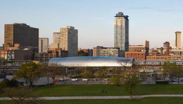
6 Cermak McCormick CTA Elevated Station


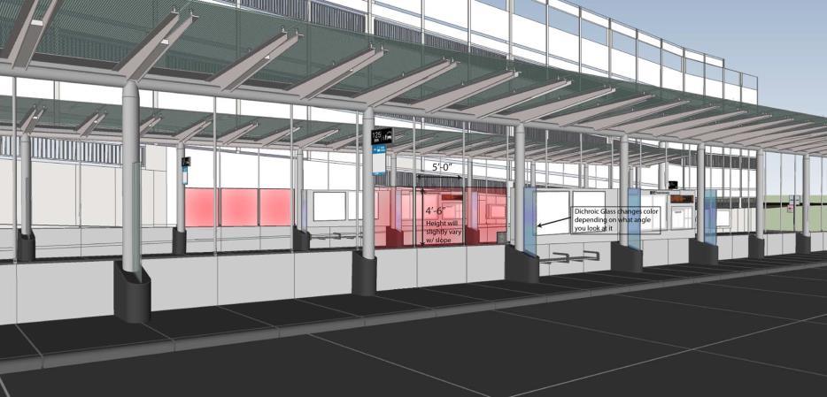
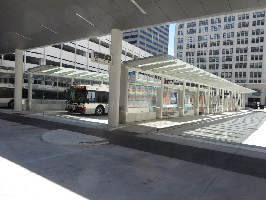
7 Union Station Transit Center

8 Washington Street Before Loop Link

9 Washington Street With Loop Link


10 Getting to Great Streets Modal hierarchy & Mode share Safe, Sustainable, Beautiful Streets Ecological Services Placemaking
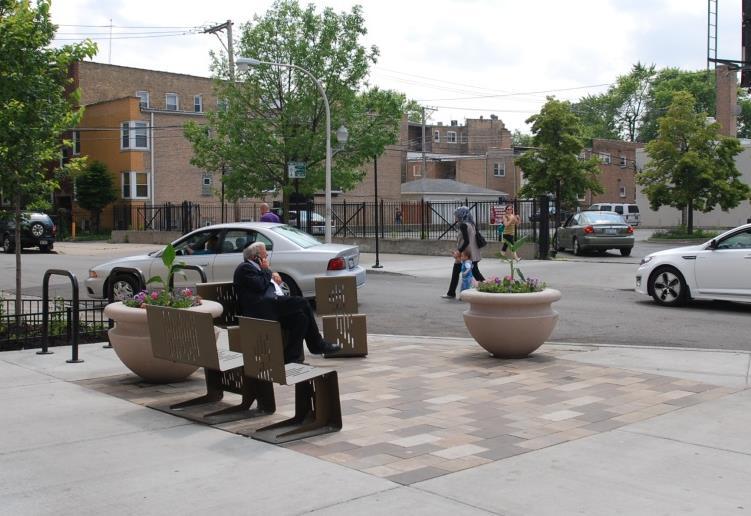
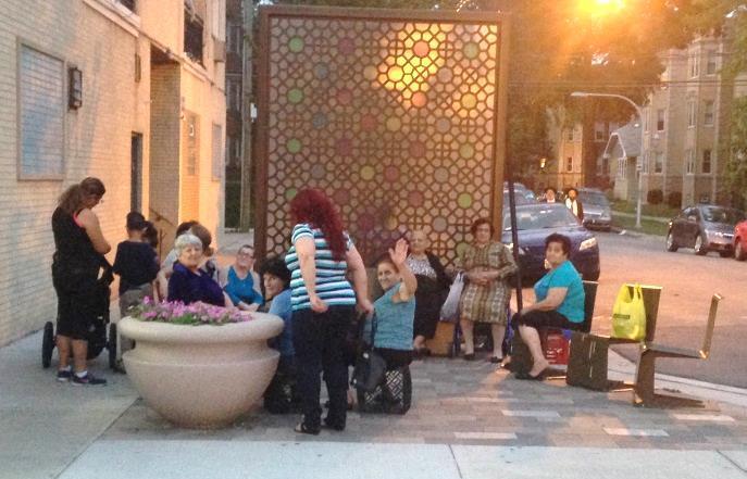
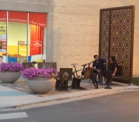
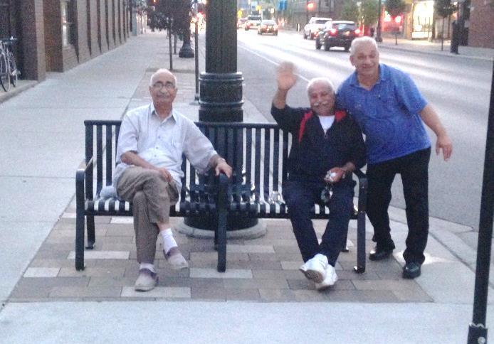
11 CDOT s Livable Streets Program CDOT s Livable Streets Program implements placemaking through the Streetscape and Sustainable Design and Make Way For People programs. Including tactical urbanism, public-private programming, and small and large capital projects. A livable street provides not only opportunities for travel on a variety of modes, but also for the range to activities that make a great community: a spot to sit and chat with neighbors, space for children to play, space for events, expression of community identity through banners, kiosks, paving choices. Placemaking Tools Street Furniture Community Identifiers Trees, planters, green space Signage and Way finding Sidewalk and Roadway pavement Bump outs and seating areas Art and Cafes Lighting Reforming the street Programming and Activation


12 Complete Streets Tools Increase Pedestrian Safety Wider sidewalks Bump-outs at intersections Pedestrian refuge islands Textured crosswalks Updated ADA ramps Buffer zone Increase Bike Safety Cycle tracks Dedicated bike lane Shared bike lane Colored pavement Sense of Identity/Community Ownership Community Identifiers


13 The Continuum of Placemaking Cultural Programming and activation Tactical Urbanism Small scale capital and full scale prototyping Large scale capital and programming implementation

14 CHIdeas
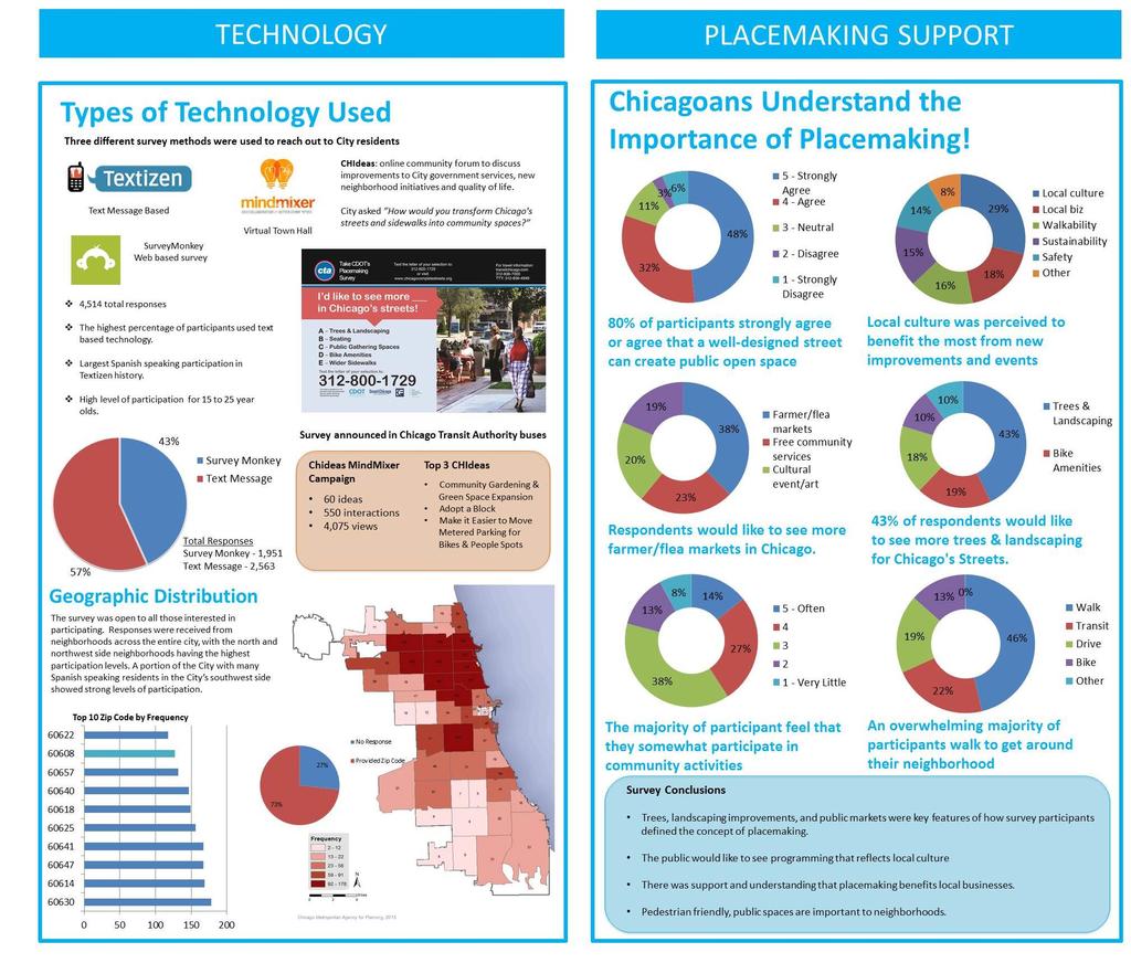
15 Placemaking Survey


16 Lawrence Avenue Streetscape Wider sidewalks Road diet Bump-outs at intersections Dedicated bike lane Pedestrian refuge islands Plaza Improvement Textured crosswalks S treet trees and landscaping Infiltration planters Permeable pavers Energy efficient white light Transit friendly infrastructure

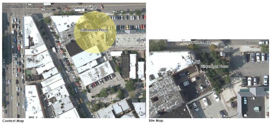

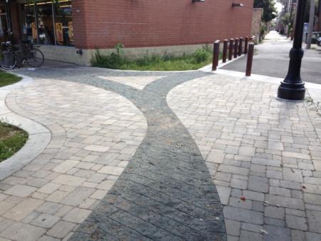
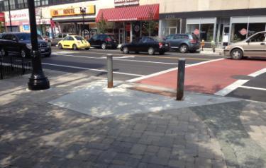
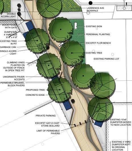
17 Lawrence Ave. Streetscape Lawrence Avenue Streetscape: Claremont Plaza


18 Devon Avenue Streetscape, Kedzie Ave to Leavitt St Wider sidewalks New street and pedestrian lighting Bump outs Seating Areas Crosswalks Trees Pavers Planters Community identifiers

19 Devon Avenue Streetscape, Kedzie Avenue to Leavitt Street


20 Fulton Market Streetscape L stop and bus routes provide for easy access the area. Flex street accommodates existing meat packers while allowing for changing uses and festival spaces New minimalistic street furniture invites on street interaction Gateway and cobbled intersections help to create a sense of place and neighborhood identity Project Scope includes: Flex street Single drive lane, wide sidewalks, flush design Enhanced Lighting Large scale street lighting with improved nighttime visibility Reclaimed cobbled intersections Gateway Section 1 Project Area L Station L Blue Line Halsted Street Bus Route


21 Argyle Shared Street Broadway to Sheridan CTA train station Asian market place Night market Community support Business support


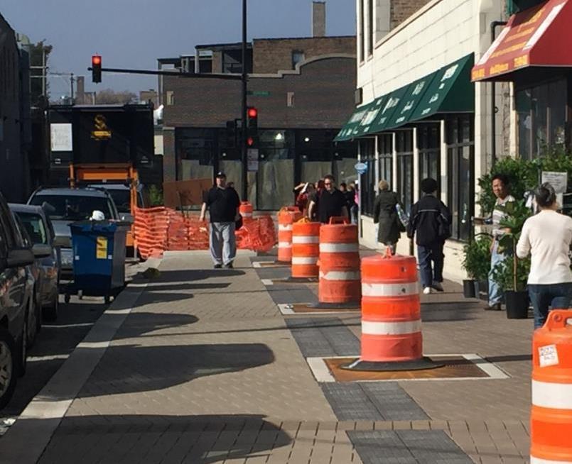
22 Argyle Shared Street Under Construction

23 Argyle Shared Street Night Market

24 Ordinance adopted in 2012 authorized CDOT to administer programs to develop outdoor public enjoyment areas, and to allow the operation of such placemaking programs Program Benefits MAKE WAY FOR PEOPLE Creates spaces that cultivate community and culture Promotes Economic Development Improves Street Safety Provides Access to Open Space Creates a strong public health agenda for Chicago Encourages Pedestrian Activity


25 Make Way for People Program People Spots Parklets / platforms on street parking zones typically along narrow sidewalks or streets with high pedestrian volumes. 47th Street People Spots Lakeview People Spots People Streets Convert excess asphalt into hardscape parks, creating safer intersections and more public open space. People Alleys Enable use of alleys for artwalks, seating and events to support placemaking and economic development. Lincoln Hub Jefferson Park People Alley Lakeview Sunday Spots Tweet Seats Pop-Up Tables & Chairs


26 State Street Median People Spot
 Year-round operation & activation of plazas that reflect an emphasis on neighborhood culture and history of each location.")
27 People Plaza Program Goals People Plazas activate existing CDOT Malls, Plazas and Triangles with new programming and retail opportunities. 1) Year-round operation & activation of plazas that reflect an emphasis on neighborhood culture and history of each location. 2) Equitable geographic distribution of People Plazas: the city has been divided into five regions; at least one plaza from each region must be activated each year, with ten plazas the first year and ten additional plazas in each additional year. 3) Local Community Participation in activation, planning and programming of performances, art exhibitions, temporary markets, etc. 4) Spur local economic development via local merchant partners. 5) Revenue Generation Capital Improvements & Upgrades: Maintenance services above and beyond current city obligations for the first two years and full maintenance services thereafter. Minor capital improvements to support proposed activation services. 6) Revenue Generation for the City The revenue will pay for annual costs of the Activation and Maintenance Services. Revenue streams can come from sponsorships, limited advertising, grants, donations, retail or other innovative solutions


28 Activate! People Plazas Public/Private Partnership started in 2015 Latent Design Corporation was selected through an RFP process to activate, maintain and upgrade People Plazas Goal to transform underutilized public plazas into cultural and economic catalysts throughout the City Builds on CDOT s Make Way for People Program Private partner raises revenues for program support through sponsorship, advertising, retail, marketing and grants Latent Design provides activation services, scheduling and programming, that includes community engagement and capacity building Quote: Latent Design

29 Equitable distribution Plazas need to be selected from one of six regions throughout the City 20 currently activated plazas 16 City neighborhoods People Plaza Locations Austin Avondale Bridgeport Chinatown Englewood Garfield Park Hegewisch Little Italy Little Village Old Town Pilsen Ravenswood/North Center University Village Uptown Wicker Park Woodlawn


30 How Do We Activate Public Plazas? On the Final Friday of every month, Activate! holds programmed events in plazas throughout the City to promote after school / work participation. Some are recurring events sponsored by community organizations or program private partners. Through MUSICAL performances Through THEATRE performances Human Beatbox, Englewood Plaza Mr. Fluxus, Woodard Plaza Theater Y at Woodard Plaza 77 Beats, Old Town School of Folk Music Jackson-Homan-Fifth Plaza


31 Through Arts & Crafts activities Through LITERARY events FrankenToyMobile, Englewood Plaza Through COMMUNITY EVENTS and initiatives Little Library Ewing + Indianapolis + 100th Movie Night, Sunnyside Mall Egg-stravaganza, Northcenter Town Square


32 Through PUBLIC ART installations Through DANCE performances Simantikos Dance, 34th & Halsted You Are Beautiful by Matthew Hoffman, Allen Lee Plaza, Chinatown Joffrey Ballet, Polish Triangle


33 Through ECONOMIC DEVELOPMENT opportunities Temporary Vendor Structures are a key component of the Make Way for People ordinance, allowing for these structures to be placed in outdoor public enjoyment areas. Boombox Prefabricated micro retail kiosk constructed from recycled shipping containers. Provide short term pop-up retail opportunities for local entrepreneurs and community activators. First Boombox was installed in Wicker Park s Mautene Court September 2015 For additional information go to


34 Changing Public Spaces Jackson-Homan-Fifth Plaza Activating the public way and engaging communities, increase pedestrian activity, promote economic development, deter crime, improve public perception of safety and provide opportunities for creative placemaking.


35 Stay In Touch Website Facebook facebook.com/cdotnews
Urban Interventions for Placemaking: Making Walkable Streets for Healthy Neighborhoods
 Urban Interventions for Placemaking: Making Walkable Streets for Healthy Neighborhoods Lunch Talks@CAF: Design for Health November 28 th, 2012 Janet L. Attarian, AIA, LEED AP BD+C Livability and Sustainable
WEST LOOP DESIGN GUIDELINES CHECKLIST
 WEST LOOP DESIGN GUIDELINES CHECKLIST Section 1.0 General Strategies 1.1 DESIGN EXCELLENCE: ENCOURAGE HIGH QUALITY AND INNOVATIVE DESIGN OF NEW BUILDINGS WITHIN THE WEST LOOP WITHOUT BEING PRESCRIPTIVE
NOVEMBER 2016 AARP IN ST. LOUIS & CITIZENS FOR MODERN TRANSIT PLACEMAKING STRATEGIES FOR ST. LOUIS TRANSIT DRAFT
 NOVEMBER 2016 AARP IN ST. LOUIS & CITIZENS FOR MODERN TRANSIT PLACEMAKING STRATEGIES FOR ST. LOUIS TRANSIT DRAFT SECTION 3 RECOMMENDATIONS AARP IN ST. LOUIS + CMT + ARCTURIS + THE INNIS GROUP 37 SECTION
Broadway/Lawrence Streetscape Design Charrette March 7, 2014
 Design Charrette March 7, 2014 Agenda Introductions Goals for Charrette Project Overview Project Scoping Alternative Development Streetscape Concepts Overview Phase 1: North of Leland Avenue 2015 construction
Fifth and Detroit Street Design May 2017 Capital Improvements Committee. DOWNTOWN Street Design
 1 Fifth and Detroit Street Design May 2017 Capital Improvements Committee Agenda 2 Review Street Configuration Prior Meeting Review Outreach Synopsis Functional Street Design Refinements Curb Edge, Turning
MISSION STREETSCAPE PLAN. Neighborhood Commercial Streets handle continuous activity. Neighborhood Commercial STREET ROW: Main Design Treatments
 Neighborhood Commercial STREET ROW: 64-80 Main Design Treatments CORNER reduce crossing distance for pedestrians, create entrances to a residential area and slow cars down. help widen sidewalk allocating
CNU CHARTER AWARDS 2018 ARGYLE SHARED STREET FACT SHEET
 CNU CHARTER AWARDS 2018 ARGYLE SHARED STREET FACT SHEET Submission Category: I. The Region: Metropolis, City and Town X II. Neighborhood, District and Corridor III. Block, Street and Building Best of title:
Sahuarita District & Phase 1 Master Plan. Town Council December 11, 2017
 Sahuarita District & Phase 1 Master Plan Town Council December 11, 2017 Visioning Study Visioning Process Advisory Group Meetings Community Questionnaire Town Center Case Studies Community Analysis The
Roanoke Rapids Streetscape Master Plan. City Council Presentation
 SCHEDULE: Stakeholder Meeting/Kick off November,2016 Master Planning Phase (November March 2017) Public Meeting #1 December 13, 2016 Review Meeting with Key Stakeholders Refine Concepts Based on Input
The University District envisions, in its neighborhood
 Envisioning the University District Link Light Rail in Seattle s neighborhoods CIY OF SEALE CONCEP-LEVEL SAION AREA PLANNING RECOMMENDAION RESOLUION # 30165 EXHIBI L Vision 08.2000 he University District
Commercial Node Plan Devine Street/Jackson Blvd. COLUMBIA, SC
 Commercial Node Plan Devine Street/Jackson Blvd. COLUMBIA, SC 9.17.13 AGENDA 1 Introductions 2 Project Update 3 Concepts 4 Recommendations 5 Next Steps Introductions Project Update Process 5-Phase Process
GREENING THE BOULEVARD Master Plan Concepts for Venice Boulevard between Lincoln and Sawtelle
 GREENING THE BOULEVARD Katherine Spitz Associates Inc. 4212½ Glencoe Avenue Marina Del Rey, CA 90292 310 574 4460 Fax 574 4462 January 2008 Table of Contents Overview Proposed Design Improvements Illustration
Lambeth Main Street Streetscape Improvements
 Lambeth Main Street Streetscape Improvements Open House October 5th, 2017 Agenda 1. Introduction 2. Project Background 3. Context 4. Project Objectives 5. Design Principles & Approach 6. Streetscape Design
Silverdale Regional Center
 Silverdale Regional Center Vision for Silverdale Regional Center The Silverdale Regional Center Plan (Plan) will guide the evolution of the Silverdale Regional Center from a collection of strip malls and
FROM DUPONT CIRCLE NORTH TO CALIFORNIA STREET, NW. Welcome!
 FROM DUPONT CIRCLE NORTH TO CALIFORNIA STREET, NW Welcome! Meeting Agenda 6:00 PM Open House 6:30 PM Presentation 7:00 PM Open House / Q&A at the Boards Project Design Team Connecticut Avenue, NW Project
Hopkins. Development Guidelines May Overview. Sponsored by: Blake Road Corridor Collaborative City of Hopkins
 Hopkins Blake Road LRT Station Area Development Guidelines May 2015 Sponsored by: Blake Road Corridor Collaborative City of Hopkins Overview Hopkins is a dynamic community of over 17,000 residents located
COMPLETE GREEN STREET CHECKLIST
 COMPLETE GREEN STREET CHECKLIST This document was developed to dissect the structure of an urban street and explore opportunities to make our streets more complete while also integrating green street strategies.
Public input has been an important part of the plan development process.
 Lakewood s Comprehensive Plan recognizes that transportation helps shape the community, and that the way the community provides for the safe and efficient movement of people affects the character of the
Jenifer Street Reconstruction Neighborhood Engagement Meeting November 4, 2015
 Jenifer Street Reconstruction Neighborhood Engagement Meeting November 4, 2015 Hosted by the Marquette Neighborhood Association Facilitated by Urban Assets Funded in part by the City of Madison Neighborhood
Lehigh Acres Land Development Regulations Community Planning Project
 Lehigh Acres Land Development Regulations Planning Effort Summary In July, 2010 Commissioner Frank Mann invited the Lehigh Acres community to start discussing how to achieve their recently adopted community
open house 3 CITY OF SALEM Downtown Streetscape Plan
 open house 3 Streetscape concepts CITY OF SALEM Downtown Streetscape Plan analysis concepts we are here refined concepts & document Feb 13th 1 2 3 apr 18th KICKOFF OPEN HOUSE Streetscape Work Group Walking
Lower Merion Commercial Districts Issues and Characteristics Handbook November 2013
 Lower Merion Commercial Districts Issues and Characteristics Handbook November 2013 DRAFT TOWNSHIP-WIDE VISION: To maintain and enhance commercial areas to complement the surrounding high-quality residential
VISION AND GUIDING DESIGN PRINCIPLES
 pleasure point commercial corridor VISION AND GUIDING DESIGN PRINCIPLES Public Draft November 26, 2018 County of Santa Cruz with assistance from MIG CONTENTS PART I: INTRODUCTION AND VISION... 3 Community
City of Dallas Complete Streets Program. SAME Infrastructure Forum February 2, 2018
 City of Dallas Complete Streets Program SAME Infrastructure Forum February 2, 2018 Complete Streets Design Manual Adopted by City Council January 27, 2016 JANUARY 27, 2016 2 What are Complete Streets?
ANCHOR TO ANCHOR. Rescale the street to create an iconic boulevard.
 ANCHOR TO ANCHOR Rescale the street to create an iconic boulevard. UR NE ER UV GO NE LA OBJECTIVES 1. Maintain appropriate traffic flow and prioritize commercial curb access 2. Mark gateways at the street
Chicago Neighborhoods 2015: Assets, Plans and Trends A project of The Chicago Community Trust
 NORTHWEST SIDE Jefferson Park Milwaukee/Lawrence Corridor Study August 2008 Community Areas: Jefferson Park Department of Planning and Development, Skidmore, Owings & Merrill LLP, Applied Real Estate Analysis,
Table of Contents. Elm Avenue Improvement Plan City of Waco, Texas. Introduction 1. Existing Context 1 Figure 1 2.
 Table of Contents Introduction 1 Existing Context 1 Figure 1 2 Plan Guidelines 3 Future Urban Form 4 The West-End 4 Main Street 6 The East-End 7 Figure 2 9 Public Improvement Recommendations 7 General
A Vibrant Downtown. Chapter 5 Cary Public Art Opportunities 31
 A Vibrant Downtown Cary s vision for Downtown is a unique, vibrant, dynamic, pedestrian friendly location; a regional destination and a place to live, work, and recreate, according to the 2001 Town Center
The Project. In 2013, construction was completed between 100 Street and 102 Street.
 The Project Jasper Avenue New Vision (JANV) is a major catalyst project identified in the Capital City Downtown Plan (2010) between 92 Street and 109 Street, including the streets half a block north and
The Village of Shirlington
 The Village of Shirlington Suburban Smart Growth Without Rail Transit July 2018 Agenda History (1940 to present) Attributes and Outcomes Lessons Learned Setting the Stage Arlington County Arlington is
Chapter 1: Introduction
 Chapter 1: Introduction The Penn Avenue Community Works Corridor Vision and Implementation Framework presents an integrated communitybased vision and a coordinated, long-term implementation framework for
BROOKLYN PARK / 85TH AVE LRT STATION CDI DEVELOPMENT GUIDELINES DRAFT
 August 2018 Page intentionally left blank The Brooklyn Park Library adjacent to the 85th Ave LRT Station Area. OVERVIEW The Blue Line LRT Extension / Bottineau corridor offers a unique opportunity to leverage
2. reimagine kings way undercroft as a community space
 2. reimagine kings way undercroft as a community space CLARENDON STREET CLARKE STREET QUEENS BRIDGE STREET MORAY STREET CITY ROAD BALSTON STREET BOYD KINGS WAY POWER STREET KAVANAGH WEST GATE FREEWAY Figure
Local Placemaking Opportunities
 What if We Built Elmira Around Places? Elmira Downtown Development Annual Meeting April 26, 2006 Planning & Design PPS Highlights 48 states, 24 countries 1200 communities 1 million visitors to our web
Guerrilla Bike Lanes & Tactical Urbanism. Ohio Transportation Engineering Conference Columbus, OH October 2016
 Guerrilla Bike Lanes & Tactical Urbanism Ohio Transportation Engineering Conference Columbus, OH October 2016 Obstacles of Place Roadways have divided us High mobility in Urban Districts Safety in the
DOWNTOWN NORFOLK COUNCIL ACTION PLAN. Strategic Initiatives Focus Area Objectives. Departmental Focus Area Key Objectives
 DOWNTOWN NORFOLK COUNCIL ACTION PLAN FY18 Strategic Initiatives Focus Area Objectives Departmental Focus Area Key Objectives STRATEGIC INITIATIVES FOCUS AREA OBJECTIVE #1: NURTURE A VIBRANT URBAN ENVIRONMENT
Place-Making Portsmouth
 Place-Making Portsmouth Jane Lafleur, MCRP Lift360 October 31, 2016 On Saturday, October 29, 2016, approximately 45 people gathered at Discover Portsmouth for an afternoon Place-Making session. Jane Lafleur,
Study Area. Capitol Way. Greening America s Capitals 11/13/2014. A Greening America s Capitals Project
 Olympia, WA: Greening Capitol Way Supporting Communities move towards sustainability is a priority for the federal government. A Greening America s Capitals Project Office of Sustainable Communities U.S.
Pedestrian and Bike Bridge LOGO
 6.2.2 Pedestrian and Bike Bridge The proposed pedestrian and bike crossing re-envisions the existing bridge at Pismo Creek on Cypress Street. The bridge is currently underutilized by vehicular through
38 Queen s University Campus Master Plan Part 1
 38 Queen s University Campus Master Plan Part 1 46 The Campus at the City Scale Chapter 4 The Campus at the City Scale 39 Queen s is an urban University centrally located in Kingston. Decisions made by
RE-Imagining the Downtown Colorado Springs Master Plan
 RE-Imagining the Downtown Colorado Springs Master Plan 2016 APA Colorado State Conference October 25, 2016 Overview 8:00 Welcome, Introductions, and Overview 8:15 Downtown s Planning History 8:30 A Market
Maplewood Avenue Downtown Complete Street Project
 Maplewood Avenue Downtown Complete Street Project Second Public Meeting January 24, 2018 Welcome and Introduction of Project Team City Planning and Public Works Staff City of Portsmouth Juliet Walker Planning
Robbinsdale LRT Station. CDI Development Guidelines. August Overview
 Robbinsdale LRT Station August 2018 Overview The City of Robbinsdale may have the coolest opportunity site along the 13 mile stretch of the Bottineau LRT corridor / Blue Line extension. Located a block
Ashland BRT Environmental Assessment: logos of CTA, CDOT, Chicago Department of Housing and Economic Development
 Ashland BRT Environmental Assessment: logos of CTA, CDOT, Chicago Department of Housing and Economic Development Overview The Chicago Transit Authority (CTA), in partnership with the Chicago Department
Pinellas County. Staff Report
 Pinellas County 315 Court Street, 5th Floor Assembly Room Clearwater, Florida 33756 Staff Report File #: 16-416A, Version: 1 Agenda Date: 3/29/2016 Subject: Election of the Chairman and Vice-Chairman of
Courthouse Square Planning & Urban Design Study. Courthouse Square Working Group #13 October 15, 2014
 Courthouse Square Planning & Urban Design Study Courthouse Square Working Group #13 October 15, 2014 1 Courthouse Square Process Working Group Community Courthouse Square Advisory Groups & Civic Associations
Streets Vision
 streets 86 2.9 Vision : The Most Prevalent and Important Public Spaces Fixed routes of human travel have served as corridors for commerce and places for human interaction from the earliest trails and foot
Hamilton Road Corridor Streetscape Master Plan. Open House October 4 th, 2017
 Hamilton Road Corridor Streetscape Master Plan Open House October 4 th, 2017 Agenda 1. Introductions Agenda Overview 2. Project Background 3. Existing Conditions 4. Strengths, Weaknesses, Opportunities
Hockessin Community Redevelopment Plan
 Hockessin Community Redevelopment Plan 3.1 Introduction The Community Redevelopment Plan for the Village of Hockessin is the result of the people s vision for a distinct village center that serves as the
1 Adapted from the Statewide Transit-Oriented Development Study by CalTrans, 2006
 APPENDIX C: LAND USE PLANNING FOR ENHANCED RAIL SERVICE 72 BACKGROUND One of the consistent themes heard from localities in the Route 29 corridor Planning Forums was the need for expanding rail service
Conceptual Design. Main Street Enhancement and Extension Project. Bothell, Washington. June 11, 2009
 Conceptual Design Main Street Enhancement and Extension Project Bothell, Washington June 11, 2009 Berger/ABAM Engineers and Cascade Design Collaborative, Inc For Main Street Bothell to succeed it must
SFMTA PHELAN LOOP AND PUBLIC PLAZA PHELAN OCEAN AVENUE
 SFMTA Municipal Transportation Agency Image: a bus in front of the Palace of the Legion of honor SFMTA PHELAN LOOP AND PUBLIC PLAZA PHELAN AVENUE @ OCEAN AVENUE Community Meeting May 23, 2012 San Francisco,
THE 355/270 CORRIDOR:
 THE 355/270 CORRIDOR: Strategic Ideas for Sustaining a Livable Work Place Project Summary ACCESS LIFE DESIGN HEALTH WORK Montgomery County Planning Department The Maryland-National Capital Park and Planning
VEHICULAR AND PEDESTRIAN CIRCULATION
 This perspective sketch communicates the intended character and quality of a proposed streetscape design. Locate benches near a major intersection where people tend to gather. Seating and lighting provide
QUESTION 8: What are your Public Realm priorities for implementation? What would you like to see happen first? TELL US WHAT YOU THINK
 Public Realm Plan How will the Public Realm Plan be implemented? The Public Realm Plan document will set out a vision for the next 30 years. Over time, Plan elements and aspects can be implemented as opportunities
Community Assistantship Program. Milaca Downtown Revitalization
 Community Assistantship Program Milaca Downtown Revitalization Prepared in partnership with City of Milaca Prepared by Zachary Jorgensen Research Assistant University of Minnesota December, 2009 CAP Report
Transportation. Strategies for Action
 Transportation A major priority for the Overlake Neighborhood is to develop a multimodal transportation system. To achieve this system, a balance has to be found among travel, circulation and access needs;
DRAFT ROOSEVELT ROAD. District Recommendations. Figure 5.23 The Roosevelt Road Corridor
 CHAPTER 5 Figure 5.23 The Road Corridor Road will develop as a mixed-use corridor, emphasizing regional retail, west of the river and mixed-use development east of the river. KEY RECOMMENDATIONS 1. High
PUBLIC RIGHT-OF-WAY IN THIS CHAPTER PUBLIC REALM
 PUBLIC RIGHT-OF-WAY This section provides design guidelines for improvements in the public right-of-way. The public right-of-way refers to streets, sidewalks, non-vehicular thoroughfares, parks and greenways
GAMMAGE SQUARE - RECOMMENDATIONS
 GAMMAGE SQUARE - RECOMMENDATIONS We envision an expanded cultural district surrounding the historic ASU Gammage. Creating a cultural district will enhance the existing historic landmark by activating the
Urban Greening Plan Proposed Policies and Programs Matrix Existing City Plans and Goals Programs Policies Notes/Comments
 Urban Greening Plan Circulation Plan for Bicyclists and Pedestrians (2007) 1.1 - Develop a coordinated Trail Maintenance Volunteer Program that identifies funding and leverages community efforts and partnerships
EXISTING PLANS Harriet Festing Center for Neighborhood Technology Midlothian Community Meeting March 12, 2015
 EXISTING PLANS Harriet Festing Center for Neighborhood Technology Midlothian Community Meeting March 12, 2015 BENEFITS Bring economic, community + environmental benefits Enhance property values Use
Cleveland Park Streetscape and Drainage Improvement Project 1
 Cleveland Park Streetscape and Drainage Improvement Project 1 Urban Context Washington, D.C. Connecticut Avenue Cleveland Park Streetscape and Drainage Improvement Project 2 Neighborhood Context Contributing
TRANSPORTATION & STREET DESIGN
 TRANSPORTATION & STREET DESIGN Review of Goals Connect neighborhoods to Square Enable access to the river Improve pedestrian environment Reorient road network to local use Three Specific Areas of Intervention
ROBBINSDALE LRT STATION CDI DEVELOPMENT GUIDELINES
 August 2018 OVERVIEW The City of Robbinsdale has a prime-opportunity site in the middle of the 13 mile stretch of the Bottineau LRT corridor / Blue Line extension. Robbinsdale offers a prominent, vital,
The Lincoln Neighborhood Corridor Plan. The LiNC
 October 1, 2014 Planning Commission Study Session The Lincoln Neighborhood Corridor Plan The LiNC Purpose of Tonight s Meeting Introduction to The LiNC Review of Existing Conditions and Community Identified
Town Center (part of the Comprehensive Plan)
") Town Center (part of the Comprehensive Plan) Mercer Island Town Center Looking North (2014) In 1994, a year-long process culminated in a set of design guidelines and code requirements for the Town Center
Town Center (part of the Comprehensive Plan) Mercer Island Town Center Looking North (2014) In 1994, a year-long process culminated in a set of design guidelines and code requirements for the Town Center
Sheridan Boulevard S TAT I O N A R E A P L A N S H E R I D A N B O U L E VA R D S TAT I O N A R E A P L A N
 Sheridan Boulevard S TAT I O N A R E A P L A N 1 City of Lakewood Adopted November, 2006 S H E R I D A N B O U L E VA R D S TAT I O N A R E A P L A N The Vision The City of Lakewood s overall vision is
5.0 WAYFINDING STREETSCAPE DESIGN MASTER PLAN 55
 OVERVIEW 57 SIGN TYPE A: GATEWAY 57 SIGN TYPES B & C: WAYFINDING KIOSKS & BOLLARDS 58 SIGN TYPES D: POLE MOUNTED ELEMENTS 59 SIGN TYPE E: LARGE-SCALE TYPOGRAPHIC INSTALLATION 60 SIGN TYPE F: VERTICAL CHOPSTICKS
Baraga Avenue PlacePlan Marquette, MI July 24 th, 2014
 Baraga Avenue PlacePlan Marquette, MI July 24 th, 2014 Presentation Outline Project Purpose Acknowledgements Placemaking Overview PlacePlan Process Design Overview PlacePlan Recommendations Physical Design
Status Report: MD 355 Project
 Status Report: MD 355 Project OCTOBER 2006 M-NCPPC MONTGOMERY COUNTY PLANNING DEPARTMENT Summary of Community Comments, and break to the Results of the MD 355 Participation Session Brookside Gardens -
Long Lost Allies? Walking Advocates & Business District Organizations. Matt Kazinka Lake Street Council. Shaina Brassard Seward Redesign
 Long Lost Allies? Walking Advocates & Business District Organizations Shaina Brassard Seward Redesign Rob Hanson West Broadway Business and Area Coalition Matt Kazinka Lake Street Council Jamie Schumacher
Carlsbad Village Redevelopment Concept Summary of Features
 Carlsbad Village Redevelopment Concept Summary of Features Calthorpe Associates November 5, 2003 The Redevelopment Concept illustrates a vision for the future of Carlsbad Village. The overall vision of
From Dismal to Great: How Underperforming Commercial Corridors are Crafting a Healthier, Better Connected Future
 From Dismal to Great: How Underperforming Commercial Corridors are Crafting a Healthier, Better Connected Future October 7, 2015 Urban Land Institute Fall Meeting San Francisco Participants: Moderator:
PIKE PINE RENAISSANCE: ACT ONE. October 19, 2017
 PIKE PINE RENAISSANCE: ACT ONE October 19, 2017 WATERFRONT SEATTLE PROGRAM PROJECT INTRODUCTION Pike and Pine streets, between First and Melrose avenues Pedestrian and streetscape improvements Budget:
The open space system should provide connective elements, relate to natural resources, and enhance the suburban character of the landscape..
 The open space system should provide connective elements, relate to natural resources, and enhance the suburban character of the landscape.. Mixed-use and infill development should maintain or enhance
City of Farmington. Downtown Plan. Amendment to the 1998 Master Plan Adopted October 11, 2004
 City of Farmington Amendment to the 1998 Master Plan Adopted October 11, 2004 Introduction Planning Background 1 Scope and Components of the Plan Amendment 2 Concept Introduction 3 Plan Concepts 3 Conceptual
The Private Role in a Public-Private Partnership. Ask Me Anything Conference May 30, 2018
 The Private Role in a Public-Private Partnership Ask Me Anything Conference May 30, 2018 1 Thoughts to Share Today Schmit+Associates Essential Elements of a P3 Community Vision Market Demand Economic Viability
5. Implementation. Challenges
 5. Implementation The Campus plan builds on the work that has been done so far by the Campus Concept Committee comprised of representatives from the North End Outreach Network (NEON), the New North Citizens
Mix of Uses Guide for Transit-Oriented Development MIX OF USES
 MIX OF USES Creating a Destination Magnet A diversity of uses such as retail, housing, offices, civic and entertainment within the TOD creates a destination magnet for transit users and TOD neighbors.
appendix and street interface guidelines
 appendix five: building and street interface guidelines appendix 5 building and street interface guidelines BOULEVARDS Boulevards are generally characterized by higher levels of traffic movement at higher
Urban Design & Placemaking
 Urban Design & Placemaking What is Urban Design? Urban Design is the discipline of creating equitable, vibrant, and sustainable places with distinct identities. The profession pulls from other built environment
Streets, Connectivity & Built Environment Working Group August 2, 2017
 Streets, Connectivity & Built Environment Working Group August 2, 2017 DOWNTOWN OAKLAND SPECIFIC PLAN WELCOME Streets, Connectivity & Built Environment Working Group Social Equity Meeting August 2, 2017
Johnson Street Bridge Public Realm Update
 Johnson Street Bridge Public Realm Update August 20, 2015 Background Johnson Street Bridge Replacement Project impacts a diverse range of stakeholders In addition to a new bridge, the project also includes
THE CIVIC DISTRICT DEVELOPMENT OPPORTUNITIES
 1 THE CIVIC DISTRICT DEVELOPMENT OPPORTUNITIES The Civic District is the physical and emotional heart of the downtown. It is also a major gateway into the central core, establishing the image and identity
SOUTH UNIVERSITY Street Design Alternatives in Progress
 1 Alternatives in Progress 2016.01.20 Meeting Agenda 2 1. Progress & Schedule 2. Utilizing the Street Design Manual 3. Site Characteristics and Input Received 4. Street Geometry What can we accomplish
6. DOWNTOWN. The Downtown Element focuses on supporting and expanding the vitality and enhancement of Downtown Chico as the City s central core.
 VISION In 2030, Downtown Chico is the heart of the community and the center of cultural activity. Engaging and active at the street level, it is a multi-story, mixed-use hub, with specialty retail, restaurants,
The Lower SaLuda Greenway
 The Lower SaLuda Greenway InITIaTIve a FLourIShInG Greenway. a hub For economic GrowTh. a ConneCTIon BeTween CoMMunITIeS. In April 2017 the Michael J. Mungo Foundation and Lexington County commissioned
A Vision for Upper Merrimack Presented by MIT Department of Urban Studies and Planning
 A Vision for Upper Merrimack Presented by MIT Department of Urban Studies and Planning A Vision for Upper Merrimack Who we are: A group of graduate students at MIT. Planning consultants for the City of
SECTION TWO: Overall Design Guidelines
 SECTION TWO: Overall Design Guidelines This section provides overall design principles and guidelines for the Gardnerville Mixed-use Overlay. They provide criteria for mixed-use places consisting of residential,
A BLUEPRINT FOR BROCKTON A CITY-WIDE COMPREHENSIVE PLAN
 A BLUEPRINT FOR BROCKTON A CITY-WIDE COMPREHENSIVE PLAN Public Meeting October 2016 1 Plan Summary and Discussion Public Meeting May 4 2017 City of Brockton Bill Carpenter, Mayor Department of Planning
City of Hermosa Beach Administrative Policy #
 City of Hermosa Beach Administrative Policy # SUBJECT: Living Streets Policy Date: Approved by: City Council Authority: Public Works Department & Community Development Department Mayor, PURPOSE The City
Village of Pemberton DOWNTOWN ENHANCEMENT INITIATIVE FRONTIER STREET PILOT PROJECT WE NEED YOUR HELP TO REVIEW THE PLAN
 Village of Pemberton DOWNTOWN ENHANCEMENT INITIATIVE FRONTIER STREET PILOT PROJECT WELCOME TO THE NEW FRONTIER STREET! WE NEED YOUR HELP TO REVIEW THE PLAN The Village of Pemberton would like your feedback
Olde Towne Vision Plan
 Olde Towne Vision Plan Introduction In 2016, the City of Bellevue will complete its move of City offices from Olde Towne Bellevue to its new municipal complex on Wall Street. The City intends to sell its
3.1 community vision. 3.3 required plan elements
 Chapter 3 Community Form 3.1 community vision 3.2 Parks & landscaping concepts 3.3 required plan elements D R A F T 20 Community Form Chapter 3 3.0 Community form 3.1 community vision The Specific Plan
Regional Placemaking: Connecting Towns as Places
 Regional Placemaking: Connecting Towns as Places Philip Myrick, Project for Public Spaces Corning, NY May 13, 2009 30 years - 1000 communities - 46 states - 12 countries Two City Streets It is difficult
Urban Design and Livability
 Urban Design and Livability City of Sacramento Planning Academy April 6, 2015 Bruce Monighan AIA Urban Design Manager, City of Sacramento How do we define cities in their characteristics of livability?
City of Tacoma Planning and Development Services
 Agenda Item E-1 City of Tacoma Planning and Development Services To: Planning Commission From: Elliott Barnett, Planning Services Division Subject: Tacoma Mall Regional Center Subarea Plan and EIS Meeting
The transportation system in a community is an
 7 TRANSPORTATION The transportation system in a community is an important factor contributing to the quality of life of the residents. Without a sound transportation system to bring both goods and patrons
INSTITUTIONAL USE DESIGN COMPATIBILITY TECHNIQUES
 INSTITUTIONAL USE DESIGN COMPATIBILITY TECHNIQUES INTRODUCTION Community institutions are an important part of the character and vitality of neighborhoods in Forsyth County. Institutional uses include