TOD GUIDANCE DOCUMENT & CITY SPECIFIC PLANS
|
|
|
- Bruce Fowler
- 5 years ago
- Views:
Transcription

 And")

1 National Dissemination Workshop Guidance Documents For Transit Oriented Development (TOD), Non-Motorised Transport (NMT) And Public Bicycle Sharing (PBS) TOD GUIDANCE DOCUMENT & CITY SPECIFIC PLANS IBI Group itrans March 4, 2016


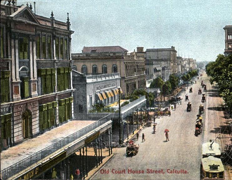
2 Where we started Source: Source: Mumbai, 1910 Calcutta, 1930


3 Where we have reached Source: Chennai UTTIPEC, India New Delhi


4 Where we are headed IBI Group IBI Group Gurgaon Naya Raipur


5 1. BAPUJI NAGAR PRECINCT CONCEPTUAL ZONING 2. MASTER CANTEEN STATION CBD TOD NODE MAHARISHI COLLEGE SQUARE 5. LAKE ZONE PRECINCT Smart Cities 4. SAHEED NAGAR PRECINCT Proposed VIEW

6 DEMYSTIFYING TOD DEMYSTIFYING TOD T = Transit frequency and usefulness O = Orienting infrastructure for making pedestrian connections between transit and development D = Development featuring a mix of uses and densities Source: Dena Belzer, Strategic Economics


7 WHAT TOD IS NOT high densities + tall buildings


8 WHAT TOD IS NOT METRO CASH AND CARY isolated developments


9 WHAT TOD IS NOT only higher order transit

10 WHAT TOD IS NOT a greenfield development model


11 WHAT TOD IS NOT 75% of our cities are middle class- need a large supply of smaller sized homes a solution to all urban problems
12 TOD: A PARADIGM SHIFT IN PLANNING INDIAN CITIES Forces mirco-level planning using the transit station as a catalyst investment Smart Growth Strategy - both land and infrastructure are used efficiently Compact nodes of moderate-to-high density Context Sensitive Design: Greenfield Redevelopment Urban Infill Mix of pedestrian-friendly land uses accessible from transit stations Walking & cycling as the primary modes for mobility Integrating the Informal Sector in Station Area Planning

13 TOD IN THE INDIAN CONTEXT Now, I am able to combine and comprehend the meaning of "Bus do kadam", "75 m" and " m which collectively signifies that the Bus should be available within do kadam i.e. within a walking distance. Mr. L.K. Panigrahi, Chief Engineer (Projects) Naya Raipur Development Authority 13

14 TOD Supportive Regulations.. Attempts in India- Ahmedabad Proposed Local Area Plans for the overlay zones Differential FSI- high in CBD area, along Sabarmati riverfront and transit corridor Removed height restrictions Increased ground coverage from existing 30% to 51% Premium FSI for energy efficient buildings Mandatory water harvesting, waste water reuse and solar energy for plot areas > 5000 sqm

15 TOD Supportive Regulations.. Attempts in India- Bangalore


16 TOD Supportive Regulations.. Attempts in India- Mumbai Shop-Line concept built into DCR/ DP Inclusionary housing requirement Parking Restrictions Differential FARs: Decentralized infrastructure In lieu of FAR as a by-right controlling mechanism use open space & parking at the parcel level to guide development

17 TOD Supportive Regulations.. Attempts in India- Naya Raipur Reduced parking standards Well-designed transit station for a high quality user experience Proposed streetscape design Active frontage- street facing buildings Mixed use development TOD supportive Ground Coverage, FAR, Height and Other Controls
18 National-level GIUIDANCE DOCUMENT
19 Lessons Learned 1. Station Area Planning to determine appropriate densification; 2. Special Overlay Zoning Districts as supplemental provisions to existing regulations 3. Differential FARs to adjust for contextual variation according to on-ground conditions; 4. Land Pooling to proactively push market towards TODs around station; 5. Density bonuses (higher FARs) in exchange of public infrastructure investments by private sector; and 6. Mixed-Use Development within a walking distance from transit stations
20 How will the Guidance Document help cities- HOW? Streamline the process of TOD planning in the country Avoid duplication of effort by individual governments/ municipalities Sensitive to contextual variations and on-ground realities Applicability at various scales Diverse user groups Flexible standard for development of Greenfield areas & redevelopment of infill areas
21 Target Users- WHO? State & Local Planning Agencies City s readiness for implementing TOD Development along transit corridors Improving infrastructure Transit Agencies Station Area Planning Active marketing of TOD opportunities Joint development at stations Private Stakeholders Real estate development Joint development opportunities

22 TOD Guidance Document - STEP BY STEP Based on: Lessons Learned from Best Practices Current Initiatives in India; and Workshop Feedback Framework for Guidance Document based on five themes

23 STEP- 1 ASSESS
24 STEP-1 ASSESS Determine the city s preparedness for undertaking TOD initiatives Defines the scale and scope of the TOD planning area Identify stakeholders for undertaking an inclusive process.
 Metro (planned) Feeder Service- Mini Buses IPT- Shared Auto Mini Bus 20% Bus 3% Walk 44% IPT 1% Car 3% 94% Potential Transit Users Two Wheeler 25% Cycle 4% 74% Potential")
25 ASSESS NATURE OF TRANSIT MUMBAI Multiple transit modes: Suburban railway- 3 Metro (1existing + 5 planned) Monorail (1 + 8 planned) BEST buses BHOPAL Expanding higher order transit service BRTS (1 operational+ 11 lines) Metro (planned) Feeder Service- Mini Buses IPT- Shared Auto Mini Bus 20% Bus 3% Walk 44% IPT 1% Car 3% 94% Potential Transit Users Two Wheeler 25% Cycle 4% 74% Potential Transit Users


26 ASSESS NATURE OF TRANSIT- BHOPAL


27 ASSESS NATURE OF TRANSIT- MUMBAI Suburban Railways Monorail BEST Services Asalpha Station Western Express Highway
28 ASSESS CURRENT INITIATIVES MUMBAI Statutory Plans Development Plan Update Regional Plan Update Other ongoing initiatives: Mobility Plan Station Area Traffic Improvement Schemes BHOPAL Statutory Plans Master Plan Update Draft Statewide TOD Policy Other ongoing initiatives: Metro DPR Preparing Zonal Plans Smart City Initiative Draft DP released in April 2015 relied heavily on TOD Principles No micro level planning initiative No integration of TOD principles with the existing statutory documents. No micro level planning initiative

29 ASSESS SCALE & SCOPE MUMBAI Corridor Versova - Andheri - Ghatkopar Metro Corridor Comparatively new transit corridor Create a basis for future development of TOD studies for all upcoming corridors. BHOPAL Priority Corridor: BRTS- TR4; Metro- Line 1 & Line 3 Corridor level TOD approach with multi-modal integration of different modes of transportation. Station Area Plan- Asalpha Identified by stakeholders


30 Assess TOD Scale- Mumbai Versova-Andheri-Ghatkopar First east-west transit link Metro Phase-I Corridor 10 Kms; 12 Stations Pilot Station- Asalpha
 Metro: Line 1 & Line 3")
31 Assess TOD Scale- Bhopal Priority Corridor: BRTS- TR4 (Operational Corridor) Metro: Line 1 & Line 3
32 Assess TOOLS HOW TO DETERMINE SCALE OF TOD PLAN?

33 ASSESS STAKEHOLDERS- BHOPAL Multiplicity of agencies Land use planning falls under the purview of Town and Country Planning at state level or development authority.

34 ASSESS STAKEHOLDERS- MUMBAI Multiplicity of agencies Overlapping roles & responsibilities Development Plan is not applicable to Special Planning Areas

35 STEP- 2 ENABLE
36 STEP-2 ENABLE
37 ENABLE PROJECT CHAMPIONS MUMBAI Identified Local Champions: Mumbai Transformation Support Unit Municipal Corporation of Greater Mumbai Formed a multi-agency Task Force BHOPAL State Agency- UD&ED was identified as nodal agency Formulated Transit Agency: Metro SPV & BRT SPV Proposed Smart City SPV Mumbai Task Force MTSU Convener IBI Group Coordinator MCGM (DP) MMRDA (T&CP) MCGM (R&T) BEST SRA Traffic Police
 Bhumi- Vikas Adhiniyam- 2012 State-wide TOD Policy underway Source: http://theperfectslum.")
38 ENABLE ADDRESS POLICY LEVEL BARRIERS MUMBAI Recommended modifications to: Master Plan; Redevelopment Policies- not linked to locational proximity to transit (Housing & Slum) BHOPAL Recommended modifications to: Existing Development Planprepared in 1995 for 2005 (No transit & land use integration) Bhumi- Vikas Adhiniyam State-wide TOD Policy underway Source:
39 ENABLE CAPACITY BUILDING MUMBAI Draft Development Plan preparation process built capacity for town planners in the MCGM Development Plan team BHOPAL Insufficient capacity building at local level
40 STEP- 3 PLAN+DESIGN


41 STEP-3 PLAN + DESIGN PRINCIPLES 12 GUIDING PRINCIPLES 9 SUPPORTNG PRINCIPLES


42 STEP-3 PLAN+DESIGN 1 MULTIMODAL INTEGRATION 2 FIRST & LAST MILE CONNECTIVITY 3 INTERCONNECTED STREET NETWORK 4 COMPLETE STREETS 5 NMT NETWORK 6 TRAFFIC CALMING


43 STEP-3 PLAN+DESIGN MIX LAND USES STREET ORIENTED BUILDING OPTIMIZE DENSITIES MANAGE PARKING INFORMAL SECTOR HOUSING DIVERSITY

44 STEP-3 PLAN + DESIGN PRINCIPLES

45 STEP-3 PLAN + DESIGN PRINCIPLES
46 STEP-3 PLAN + DESIGN Template to develop a TOD Plan / Policy/ Strategy for the applicable scale- City, Corridor, Station & Site TOD Guiding Principles
47 PLAN + DESIGN PLANNING PROCESS MUMBAI Corridor level analysis Mapped station-wise issues and opportunities Developed Station Area Typologies Proposed mode share and development targets Identified corridor-wide strategies and implementation mechanisms Selected Pilot Area Delineated Station Area Plan boundary Prepared Station Area Planning Framework Planning Outcomes: Land Assembly Plan, Traffic and Parking Plan, Public Realm Plan BHOPAL Corridor level analysis Mapped station-wise development opportunities Developed Station Area Typologies Proposed mode share and development targets Identified corridor-wide strategies and implementation mechanisms Proposed priority Station Areas Recommended station accessibility improvements

48 PLAN+DESIGN TOOL-3A- CITYWIDE
49 PLAN+DESIGN TOOLS TOOL 3: HOW TO CREATE TOD PLANS- Citywide, Corridor, Station & Site? TOOL 4: HOW-TO PREPARE DEVELOPMENT CONTROL REGULATIONS (DCRs) MODIFICATION

50 Station Area Planning- Mumbai- Asalpha Pilot Study


51 Mumbai- Asalpha Station Area - Characteristics


52 Asalpha Station Area Characteristics

53 Station Area Planning Framework- Asalpha Station

54 Asalpha Station Area Planning Layers 1 Environment and Historic


55 Asalpha Station Area Planning Layers 1 Environment and Historic


56 Asalpha Station Area Planning Layers 2 Existing and Proposed Settlements
57 Asalpha Station Area Planning Layers 3 Transit Corridors

58 Asalpha Station Area Planning Layers 4 Street Grid

59 Asalpha Station Area Planning Layers 4 Street Grid

60 Asalpha Station Area Planning Layers 4 Street Grid

61 Asalpha Station Area Planning Layers 4 Street Grid


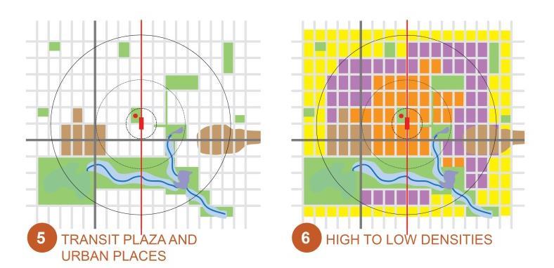
62 Asalpha Station Area Planning Layers 5 Transit Plaza and Urban Places


63 Asalpha Station Area Planning Layers 6 High to Low Densities

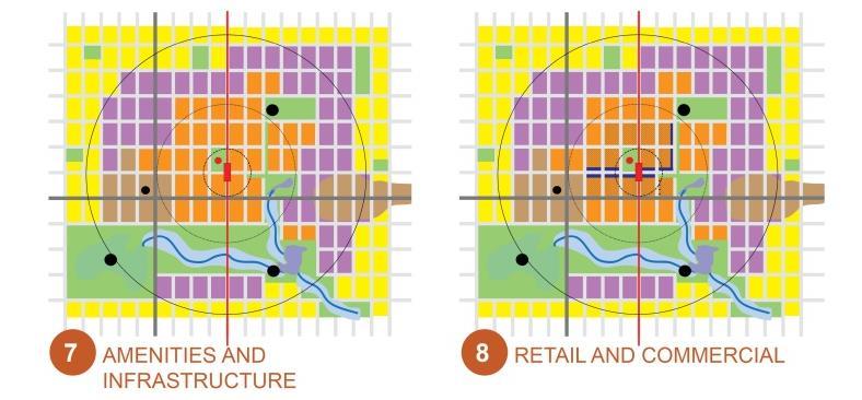
64 Asalpha Station Area Planning Layers 7 Amenities and Infrastructure


65 Asalpha Station Area Planning Layers 8 Retail and Commercial


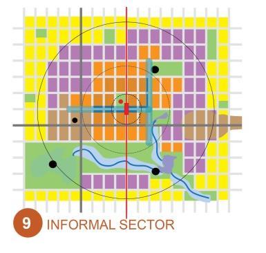
66 Asalpha Station Area Planning Layers 9 Informal Sector

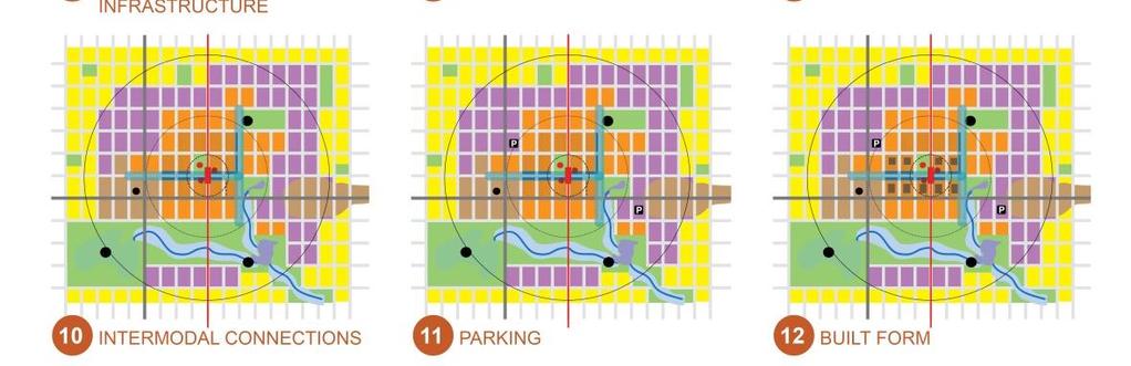
67 Asalpha Station Area Planning Layers 10 Intermodal Connections

68 Asalpha Station Area Planning Layers 11 Parking Hyper TOD Zone No Parking Medium Density 0.35 per 100 sqm Low Density 0.5 per 100 sqm Amenities per 100 sqm

69 Asalpha Station Area Planning Layers 12 Complete Streets and Built Form Ground Coverage = 40% - 80%

70 Station Area Traffic and Parking Management Plan Hyper TOD Zone No Parking Medium Density 0.35 per 100 sq.m. Low Density 0.5 per 100 sq.m. Amenities per 100 sq.m.

71 Land Assembly Plan Residential Mixed Use(R-C Zone) 26% Exisiting Developm ent 7% Roads 26% Industrial 3% Commercial Mixed Use Zone 10% Community Facilities 1% Health 2% Education 6% NDZ 6% Open Spaces 13%

72 Asalpha Station Area Development Targets
73 STEP- 4 INVEST
74 STEP-4 INVEST Adequate financing including augmenting the private sector s role Benefits of increased land values for implementing TOD
75 INVEST FINANCING TOOLS 1. Land Banking- Urban Infill 2. Land Pooling- TP Schemes (Greenfield) 3. Premium FARs in exchange of providing: Public amenities Public open space Achieving IGBC or Green Building certification Affordable housing units Public access for creating small block sizes 4. Transit Agency: Rail + Property Land Value Capture Joint Development 5. Align with Smart City Project/ funding & other central government programs

76 INVEST FINANCING TOOLS

77 STEP- 5 IMPLEMENT
78 STEP-5 IMPLEMENT Innovative implementation mechanisms Development of review checklist for local staff
79 IMPLEMENT PHASING STRATEGY Development Potential Vacant Land Availability Government owned lands Market Strength Infrastructure Carrying Capacity Balanced Employment + Population Distribution Identify Origin & Destination Station Land Use Mix Improved Station Accessibility First and Last Mile Connectivity Multimodal Integration Walkability to Station Parking Timing: Long Term TOD Opportunity Short-Term TOD Priority Emerging TOD Market Inactive TOD Market


80 IMPLEMENT PHASING STRATEGY- BHOPAL Development Opportunities Habibganj Station ISBT Accessibility Destination areas that have high footfall for pedestrians: Habibganj Naka University Gate Nanke Petrol Pump Top N Down Roshanpura Nadra Bus Stand Bhopal Talkies
81 IMPLEMENT ROLES AND RESPONSIBILITY- MUMBAI
82 IMPLEMENT STATUTORY RELEVANCE MUMBAI BHOPAL Recommendations for DCRs: Allow variable FSI and provide incentive FSI for affordable housing and sidewalk improvement No parking adjacent to transit station and reduced and shared parking proximate to station. Parking included in FSI if above grade. Prohibit dead compound walls Provide active front setbacks varying with street widths Include min sidewalk requirements as per street width Prepare State-wideTOD policy and relevant bye-laws Establish a TOD Overlay District as a Special Area in Development Plan under preparation Notification of Rules & Regulations to establish statutory relevance for TOD Principles.

83 IMPLEMENT MONITORING AND EVALUATION
84 CSP Key Inputs to Guidance Document Learnings Guidance Document Input Developing a station area plan was MCGM s priority Data availability challenges could potentially derail TOD process Multiple stakeholders within a Task Force facilitated information exchange and agreements Implementation roles can affect project delivery Lack of knowledge about accessibility component of TOD The Guidance Document must recognize a city s needs and be applicable at all scales The Step-by-Step TOD Process must be flexible to accommodate data challenges TOD Task Force must be multidisciplinary and multi-agency Implementation roles must be specified to ensure delivery of project goals Accessibility can be addressed at smaller scales. Pilot projects should be encouraged

85 IBI GROUP GENERIC GUIDANCE DOCUMENT & CITY SPECIFIC PLANS- TOD Session 1: Panel Discussion

86 CHALLENGES IN INTEGRATED TOD PLANNING Conflicting Policies & Values Overlapping Institutional Responsibilities Timing of Transit & Land Use Decisions Obsolete Development Regulations Lack of structure in Real Estate Markets Technical Capacities
SUSTAINABLE TRANSPORT & INTEGRATED LAND USE PLANNING
 SUSTAINABLE TRANSPORT & INTEGRATED LAND USE PLANNING UNESCAP Capacity Building Workshop, Colombo Integrated Land use and Urban Transport Planning : Principles and Practices 31st October 2017 ACTIVE TRANSPORTATION
TRANSIT ORIENTED DEVELOPMENT
 TRANSIT ORIENTED DEVELOPMENT Dhaka September 13, 2018 Prof. H. M. Shivanand Swamy Centre of Excellence in Urban Transport Why TOD? Economic Increased Density in prime, Convenient Locations Environmental
Integrated Multi Modal Public Transit Hub
 Leaders Programme in Urban Transport Planning and Management Integrated Multi Modal Public Transit Hub at Central Business District- Ahmedabad Neela Munshi (Senior Town Planner) Deepa Dave (AM Urban Planner)
Town of Oakville Streetscape Strategy
 Town of Oakville Streetscape Strategy Endorsed by PDC on February 10, 2014 (PD-011-14) Town of Oakville Streetscape Strategy [endorsed by PDC February 10, 2014] 0 Town of Oakville Streetscape Strategy
LEADERS IN URBAN TRANSPORT PLANNING. Ahmedabad Urban Development Authority
 LEADERS IN URBAN TRANSPORT PLANNING Ahmedabad Urban Development Authority Regional Context Gandhinagar Twin City 4 Growth centers and Satellite Towns Sanand SIR, Changodar SIR Dholera SIR, SEZs 2 What
MPD 2021 Review TOD Policy
 MPD 2021 Review TOD Policy CURRENT CITY PATTERN: Population Density evenly distributed all over city. Large Travel distances & pollution due to segregated land use and vehicular dependency. Rohtak Road
TRANSIT-ORIENTED DEVELOPMENT POLICY DRAFT. City Planning and Development Department Kansas City, Missouri
 TRANSIT-ORIENTED DEVELOPMENT POLICY DRAFT City Planning and Development Department Kansas City, Missouri What is Transit Oriented Development (TOD)? Development that focuses land uses around a transit
An advanced tool for assessing and guiding sustainable urban development
 Improving Transportation Demand Management through Sustainable Urban Planning and Design: Recommendations from International Green Model City Initiative (IGMC) Lu Haifeng Secretary-General Global Forum
Urban Design Manual PLANNING AROUND RAPID TRANSIT STATIONS (PARTS) Introduction. Station Study Areas
 Introduction. Station Study Areas") 111111 PLANNING AROUND RAPID TRANSIT STATIONS (PARTS) Introduction The ION rapid transit system will link Waterloo, Kitchener and Cambridge through a central transit corridor (CTC). There are a number
111111 PLANNING AROUND RAPID TRANSIT STATIONS (PARTS) Introduction The ION rapid transit system will link Waterloo, Kitchener and Cambridge through a central transit corridor (CTC). There are a number
PLAN ELEMENTS WORKSHOP. April 5, 2016
 PLAN ELEMENTS WORKSHOP April 5, 2016 needs more housing. But there is no one-size fits-all solution. Every neighborhood has its own character. In some places, density is not only appropriate it is badly
Municipal Development Plan Update Urban Service Area and Hamlets
 ENCLOSURE 1 Municipal Development Plan Update Urban Service Area and Hamlets Priorities Committee January 24, 2017 MUNICIPAL DEVELOPMENT PLAN UPDATE SHAPING OUR FUTURE MDP Update - Agenda MDP Update Public
Complete Neighbourhood Guidelines Review Tool
 Complete Neighbourhood Guidelines Review Tool Prepared By: City of Regina Planning Department October 2014 Page 1 of 14 Community Development Review Checklist for Secondary Plans and Concept Plans The
Making TOD Work in the Heart of Suburban Sprawl
 Making TOD Work in the Heart of Suburban Sprawl Rocky Mountain Land Use Institute March 6, 2009 Speakers Ben Herman, FAICP, Principal Clarion Associates Darcie White, AICP, Principal Clarion Associates
CDAC. Update: Downtown Dartmouth Update: CDAC July 25 th Motion
 CDAC Update: Downtown Dartmouth Update: CDAC July 25 th Motion 2018-10-24 Downtown Dartmouth Plan Open House October 22, 2018 6:00 pm Open House 6:30 pm Presentation + Q&A 7:20 pm Open House 8:30 pm Close
CHAPTER 7: Transportation, Mobility and Circulation
 AGLE AREA COMMUNITY Plan CHAPTER 7 CHAPTER 7: Transportation, Mobility and Circulation Transportation, Mobility and Circulation The purpose of the Transportation, Mobility and Circulation Chapter is to
Status Report: MD 355 Project
 Status Report: MD 355 Project OCTOBER 2006 M-NCPPC MONTGOMERY COUNTY PLANNING DEPARTMENT Summary of Community Comments, and break to the Results of the MD 355 Participation Session Brookside Gardens -
Tyvola & Archdale Transit Station Area Plan. June 5, 2008
 Tyvola & Archdale Transit Station Area Plan Second Public Meeting June 5, 2008 Presentation Outline 1. Purpose and Process 2. Station Area Overview 3. Plan Recommendations 4. Comments Received and Proposed
D-O LRT Zoning Discussion. Chapel Hill Boards & Commissions October 16, 2017
 D-O LRT Zoning Discussion Chapel Hill Boards & Commissions October 16, 2017 Update on Overall D-O LRT Station Area Initiative Objectives Design and educate on principles of Good Transit-Oriented Development
The West Vaughan Employment Area Secondary Plan Policies
 Part 2: The West Vaughan Employment Area Secondary Plan Policies 2.1 General Policies It is the policy of Council: 2.1.1. That the West Vaughan Employment Area (the WVEA), identified on Schedule 1, will
Lesson 6. Corridor Planning
 Lesson 6 Corridor Planning 1 Learning Outcomes Identify land use strategies and solutions that can be incorporated into multimodal transportation corridor plans Identify land use stakeholders and describe
MONTGOMERY COUNTY METRO STATION AREA DESIGN CHARRETTE
 MONTGOMERY COUNTY METRO STATION AREA DESIGN CHARRETTE Shady Grove Metro Station Area Charrette Closing Presentation October 25-28, 2000 MONTGOMERY COUNTY, MD M-NCPPC Design Collective, Inc. Architects
Implementation Guide Comprehensive Plan City of Allen
 Implementation Guide 2030 Comprehensive Plan City of Allen DRAFT 2015 Implementation Guide Allen 2030 Comprehensive Plan INTRODUCTION The Comprehensive Plan serves as a guide for the growth and development
Cobb County Design Guidelines Mableton Parkway & Veterans Memorial Highway Community Design Workshop January 12, 2017
 Community Design Workshop January 12, 2017 Agenda Opening Remarks / Introductions Scope of Work Existing Conditions Key Issues / Opportunities VPS Summary Draft Vision & Goal Statement Implementation Concepts
Annexure 1. STRATEGY for better Urban Form
 Annexure 1 STRATEGY for better Urban Form Demarcate the planning localities Mapping of the city should be carried out to identify the various localities. These localities can be mapped based on similarities
Integrated Urban Development. April Reflections from the NZPI Study Tour of Portland, Seattle and Vancouver
 Integrated Urban Development April 2009 Reflections from the NZPI Study Tour of Portland, Seattle and Vancouver Integrated Urban Development Urban Growth Management Transportation Transit Orientated Mixed
Chapter 1: Introduction
 Chapter 1: Introduction The Penn Avenue Community Works Corridor Vision and Implementation Framework presents an integrated communitybased vision and a coordinated, long-term implementation framework for
TRANSIT ORIENTED DEVELOPMENT PINELLAS COUNTY MPO LIVABLE COMMUNITIES INITIATIVE PINELLAS COUNTY COMPREHENSIVE PLAN AMENDMENTS
 PINELLAS COUNTY MPO LIVABLE COMMUNITIES INITIATIVE MODEL LAND DEVELOPMENT CODE TRANSIT ORIENTED DEVELOPMENT PINELLAS COUNTY COMPREHENSIVE PLAN AMENDMENTS MPO Livable Communities Initiative Goal: Improve
Stakeholders Advisory Working Groups (SAWGs) Smart Growth and TOD Land Use (#11) SAWG Meeting
 Smart Growth and TOD Land Use (#11) SAWG Meeting") Presentation - Part II Tappan Zee Bridge/I-287 Corridor Project July 21, 2010 Slide 1. David Kooris (Regional Plan Association) welcomed members of the Land Use Stakeholders Advisory Working Groups (SAWGs)
Presentation - Part II Tappan Zee Bridge/I-287 Corridor Project July 21, 2010 Slide 1. David Kooris (Regional Plan Association) welcomed members of the Land Use Stakeholders Advisory Working Groups (SAWGs)
Blueprint Denver Task Force Meeting #16 February 22, 2018
 Blueprint Denver Task Force Meeting #16 February 22, 2018 Agenda Welcome, Meeting Overview and Process Update Change Categories Small Group Recommendations Discussions: Land Use and Built Form General
TRANSPORTATION ELEMENT GOALS, OBJECTIVES, AND POLICIES
 TRANSPORTATION ELEMENT GOALS, OBJECTIVES, AND POLICIES GOAL 2 The City shall provide a safe, convenient, effective, and energy efficient multimodal transportation system which is coordinated with the Future
GO Station Mobility Hubs: Draft Precinct Plans. Committee of the Whole July 12, 2018
 GO Station Mobility Hubs: Draft Precinct Plans Committee of the Whole July 12, 2018 Purpose of this Workshop Present Draft Precinct Plans for the 3 GO Station Mobility Hubs Continue the conversations that
DELIVERING ON THE TRANSIT PROMISE
 DELIVERING ON THE TRANSIT PROMISE Dena Belzer October 6, 2015 Presentation Overview 1. Puget Sound As a Transit Region: Putting SeaTac in Context 2. Starting at the Beginning: How Does TOD Work? 3. Strategies
LEED-ND 101: Practical Strategies for Achieving Sustainability Goals. Travis Parker Lakewood Planning Director
 LEED-ND 101: Practical Strategies for Achieving Sustainability Goals Travis Parker Lakewood Planning Director Metro Vision Idea Exchange Oct 11, 2012 West Corridor Stations West Corridor Overview West
Downtown Hamilton Transit Terminal
 Downtown Hamilton Transit Terminal T R A N S I T - S U P P O R T I V E U R B A N D E S I G N G U I D E L I N E S A L I S S A G O L D E N M A S T E R S R E P O R T J U L Y 2 0 0 9 S C H O O L O F U R B
3. Endorse the LRT vision in transforming Surrey into Connected-Complete-Livable communities, and more specifically, the official vision statement:
 CORPORATE REPORT NO: R038 COUNCIL DATE: February 20, 2017 REGULAR COUNCIL TO: Mayor & Council DATE: February 16, 2017 FROM: General Manager, Engineering FILE: 8740-01 SUBJECT: Surrey Light Rail Transit
Ryoko Iizuka Finance, Economics and Urban Department
 THE WORLD BANK www.worldbank.org/eco2 Eco 2 Cities Guide Ryoko Iizuka Finance, Economics and Urban Department 09.12.2011 1 Challenge: How? The 350 page Eco 2 Book elaborates on the principles, methods
13 THORNHILL YONGE STREET STUDY IMPLEMENTATION CITY OF VAUGHAN OPA 669 AND TOWN OF MARKHAM OPA 154
 13 THORNHILL YONGE STREET STUDY IMPLEMENTATION CITY OF VAUGHAN OPA 669 AND TOWN OF MARKHAM OPA 154 The Planning and Economic Development Committee recommends the adoption of the recommendations contained
REVIEW AND EVALUATION OF REGIONAL LAND USE
 REVIEW AND EVALUATION OF REGIONAL LAND USE AND TRANSPORTATION SCENARIOS #220831 Environmental Justice Task Force October 7, 2014 VISION 2050 Process Development of Guiding Vision for Land Use and Transportation
Blueprint Denver A BLUEPRINT FOR AN INCLUSIVE CITY. Executive Summary
 Blueprint Denver A BLUEPRINT FOR AN INCLUSIVE CITY Executive Summary PUBLIC REVIEW DRAFT 2 1/7/2019 DENVERIGHT BLUEPRINTDENVER Blueprint Denver: A Blueprint for an Inclusive City An Equitable City Planning
The transportation system in a community is an
 7 TRANSPORTATION The transportation system in a community is an important factor contributing to the quality of life of the residents. Without a sound transportation system to bring both goods and patrons
TOD strategy in LAC Region
 HOW TRANSIT ORIENTED DEVELOPMENT -TOD -COULD TRANSFORM URBAN SPACE Vanessa Velasco, Urban Specialist. welascobernal@worldbank.org Source: Metro Sabana,2017 TOD strategy in LAC Region 1. TOD context 2.
SPRINGHILL LAKE TRANSIT VILLAGE
 Greenbelt Metro Area Sector Plan - Subarea Design Policies and Guidelines - Springhill Lake Transit Village 113 SPRINGHILL LAKE TRANSIT VILLAGE Residential Neighborhood and Village Center CONCEPT Springhill
Town Center (part of the Comprehensive Plan)
") Town Center (part of the Comprehensive Plan) Mercer Island Town Center Looking North (2014) In 1994, a year-long process culminated in a set of design guidelines and code requirements for the Town Center
Town Center (part of the Comprehensive Plan) Mercer Island Town Center Looking North (2014) In 1994, a year-long process culminated in a set of design guidelines and code requirements for the Town Center
PUBLIC OPEN HOUSE HURONTARIO-MAIN CORRIDOR SECONDARY PLAN
 PUBLIC OPEN HOUSE HURONTARIO-MAIN CORRIDOR SECONDARY PLAN Tuesday, February 28, 2012 6pm 9pm 1 st Floor Atrium, City Hall 2 Wellington Street West, Brampton 1 POLICY FRAMEWORK The 2006 Provincial Growth
PART 5: DEVELOPMENT FRAMEWORK Figure 57: Proposed Height
 Figure 57: Proposed Height 103 Figure 58: Proposed Land Use 104 Figure 59: 3D Image of the Initial Height and Land Use in the Study Area 105 4.3.2 Landmarks and Nodes The growth of Sandton from an out
1.3 TRANSIT VISION 2040 FROM VISION TO ACTION THEME 1: PUTTING TRANSIT AT THE CENTRE OF COMMUNITIES. Fully integrate transit with community planning
 TRANSIT VISION 2040 FROM VISION TO ACTION TRANSIT VISION 2040 defines a future in which public transit maximizes its contribution to quality of life with benefits that support a vibrant and equitable society,
Transportation Land Use Integration & Regional Planning. Don Kostelec, AICP Senior Planner, Louis Berger Group February 1, 2010
 Transportation Land Use Integration & Regional Planning Don Kostelec, AICP Senior Planner, Louis Berger Group February 1, 2010 Transportation Land Use Integration DOT-HUD-EPA Sustainable Communities Initiative
City of Villages Parking Strategies. William Anderson, FAICP City Planning & Community Investment San Diego Parking Symposium July 14, 2006
 City of Villages Parking Strategies William Anderson, FAICP City Planning & Community Investment San Diego Parking Symposium July 14, 2006 City of Villages Strategy A hierarchy of walkable, mixed use districts
TRANSIT ORIENTED DEVELOPMENT PROMOTING INTEGRATED LAND USE AND TRANSIT PLANNING
 TRANSIT ORIENTED DEVELOPMENT PROMOTING INTEGRATED LAND USE AND TRANSIT PLANNING Presented by: Trevor McIntyre, Director, IBI Group Bankim Kalra, Team Leader- Urban Planning and Design, IBI Group India
Transit / Housing Oriented Redevelopment
 Broward County Urban Planning and Redevelopment Department Kick-Off Meeting October 24, 2007 Transit / Housing Oriented Redevelopment 1 Future Land Use 2 Broward County Charter Voters approved in 1974.
TOD 203 CORRIDOR PLANNING and TOD
 2 CORRIDOR PLANNING and Scales of What You Will Learn The Transit Corridor Types of Corridors Objectives and Strategies for Transit and at the Corridor Level Main Street Corridor Planning and Your Trainers
City of Tacoma Planning and Development Services
 Agenda Item E-1 City of Tacoma Planning and Development Services To: Planning Commission From: Elliott Barnett, Planning Services Division Subject: Tacoma Mall Regional Center Subarea Plan and EIS Meeting
UDF PLANS AND GUIDELINES
 UDF PLANS AND GUIDELINES 5 Land Use Land Use Development Plan Plan no. 3 Land Use Development Mixed Use Retail / Leisure Residential Civic and Institutional Proposed Zoning Table Development Edges Plan
WELCOME and introduction
 1 WELCOME and introduction Mobility Hub Locations within Burlington STUDY OVERVIEW STUDY OBJECTIVES The City of Burlington is developing four Area Specific Plans, one for each of Burlington s Mobility
Plano Tomorrow Vision and Policies
 Plano Tomorrow Vision and Policies PLANO TOMORROW PILLARS The Built Environment The Social Environment The Natural Environment The Economic Environment Land Use and Urban Design Transportation Housing
Employment and Commercial Review Analysis of Policy Directions
 Employment and Commercial Review Analysis of Policy Directions Appendix A The following analysis is town staff s response to the policy directions provided by the consultants who prepared the Employment
THE 355/270 CORRIDOR:
 THE 355/270 CORRIDOR: Strategic Ideas for Sustaining a Livable Work Place Project Summary ACCESS LIFE DESIGN HEALTH WORK Montgomery County Planning Department The Maryland-National Capital Park and Planning
2040 LUP is a part of the Comprehensive Plan and carries the same legal authority. Economic Challenges
 1.1. Guiding Anchorage s Growth Where will new residents settle over the next two decades? Where will people work, shop, and play? Will there be enough room to grow? How will Anchorage look? Will growth
Public Open House #1
 Public Open House #1 TONIGHT S AGENDA Welcome Project Overview The Big Picture The Station Area The Analysis Thoughts about Future Change Breakout Group Discussions Summation / Next Steps Project Overview
CHAPTER 12 IMPLEMENTATION
 CHAPTER 12 IMPLEMENTATION The 2010 Town of Denton Comprehensive Plan is intended to capture a vision of the future of Denton. As such, it provides a basis for a wide variety of public and private actions
TREASURE COAST REGIONAL PLANNING COUNCIL M E M O R A N D U M. To: Council Members AGENDA ITEM 5H
 TREASURE COAST REGIONAL PLANNING COUNCIL M E M O R A N D U M To: Council Members AGENDA ITEM 5H From: Date: Subject: Staff October 17, 2008 Council Meeting Local Government Comprehensive Plan Review Draft
Status Update (2006 vs. Now) Citizen s Advisory Committee February Plan for Prosperity
 Citizen s Advisory Committee February Plan for Prosperity") Status Update (2006 vs. Now) Citizen s Advisory Committee February 2018 Plan for Prosperity 2000 2017 2000 2017 Gardnerville Population 6,000 5,760 5746 5,500 5,000 5,067 5,550 5,165 5,394 5,412 5,250
Status Update (2006 vs. Now) Citizen s Advisory Committee February 2018 Plan for Prosperity 2000 2017 2000 2017 Gardnerville Population 6,000 5,760 5746 5,500 5,000 5,067 5,550 5,165 5,394 5,412 5,250
Chapter 4. Linking Land Use with Transportation. Chapter 4
 Chapter 4 Linking Land Use with Transportation Chapter 4 59 Chapter 4 Linking Land Use with Transportation Community Design and Transportation Program Introduction Since the 1950s, the predominant development
Edward R. Sajecki Commissioner of Planning and Building
 Corporate Report Clerk s Files Originator s Files CD.03.POR DATE: TO: FROM: SUBJECT: Chair and Members of Planning and Development Committee Meeting Date: February 27, 2012 Edward R. Sajecki Commissioner
Port Credit Local Advisory Panel October 20 th Meeting
 Port Credit Local Advisory Panel October 20 th Meeting Focus Of This Evening s Meeting: 1. Hurontario Main Street Higher Order Transit Study 2. Port Credit Mobility Hub & GO Station Parking Structure Study
Tony Garcia, City-County Planning Commission & Beth Alden, Hillsborough MPO
 Tony Garcia, City-County Planning Commission & Beth Alden, Hillsborough MPO TOD Defined A compact neighborhood with housing, jobs and neighborhood services within easy walking distance of a transit station
City of Fort Lauderdale UPTOWN URBAN VILLAGE. Public Workshop December 7, 2016
 Public Workshop December 7, 2016 Workshop Agenda Introductions Project Presentation o o o History Project Scope/Timeline Character of Study Area o o o o Land Use Public Realm/Pedestrian Mobility Multimodal
TOWN OF NEW CASTLE - Master Plan Update
 Our Presentation Today (1) Recap the Master Planning Process To Date (2) Present the Outline of the Master Planning Work Plan (3) Present the Calendar for the Master Plan (4) Outline the scope of a Downtown
Midtown Greenway Land Use and Development Plan Executive Summary
 Midtown Greenway Land Use and Development Plan Executive Summary Introduction The Midtown Greenway Land Use and Development Plan sets policy direction for land use and development in the Midtown Greenway
Welcome. Walk Around. Talk to Us. Write Down Your Comments
 Welcome This is an information meeting introducing the applications for proposed redevelopment of the Yorkdale Shopping Centre site at 3401 Dufferin Street and 1 Yorkdale Road over the next 20+ years,
City of Long Beach. creating vibrant and exciting places
 City of Long Beach creating vibrant and exciting places Land Use Element Urban Design Element Overview of the two draft General Plan elements Discuss areas of change Economic goals of the plans Case study
Mobility Hub Guidelines: Tools for Achieving Successful Station Areas
 Mobility Hub Guidelines: Tools for Achieving Successful Station Areas This paper introduces Metrolinx s recently released Mobility Hub Guidelines and highlights two key aspects of the document: the importance
FUNDING CORRIDOR REVITALIZATION
 FUNDING CORRIDOR REVITALIZATION Integrated corridor planning for the 21 st Century America Planning Association Annual Conference Atlanta, GA April 27, 2014 Mariia Zimmerman, MZ Strategies, LLC mariia@mzstrategies.com
City of Bristol Route 6 Corridor Implementation Program
 City of Bristol Route 6 Corridor Implementation Program FITZGERALD & HALLIDAY, INC. Innovative Planning, Better Communities June 2017 Route 6 Corridor Plan IMPLEMENTATION PROGRAM The following Implementation
Official Plan Review
 Official Plan Review Summary Report - The Built Environment August 2014 Part 1: Introduction Planning for a healthy, prosperous and sustainable community is an important goal for our municipality. From
Cumberland Region Tomorrow is a private, non-profit, citizen based regional organization working with Greater Nashville Regional Council
 Cumberland Region Tomorrow is a private, non-profit, citizen based regional organization working with Greater Nashville Regional Council and others in the public and private sectors, dedicated to planning
5 th Regional EST Forum in Asia A new decade in sustainable transport
 5 th Regional EST Forum in Asia A new decade in sustainable transport Keynote address on India s Experience in Implementing Sustainable Urban Transport By Sri Saugata Roy Hon ble Minister of State for
City of Lake Mary, Florida. Evolution of a Historic Downtown with Transit Oriented Development Strategies
 City of Lake Mary, Florida Evolution of a Historic Downtown with Transit Oriented Development Strategies What is Transit Oriented Development? Walkable villages located at and around transit stations in
Subregion 4 Central Avenue-Metro Blue Line Corridor Transit-Oriented Development (TOD) Implementation Project. Community Meeting April 27, 2011
 Implementation Project. Community Meeting April 27, 2011") Subregion 4 Central Avenue-Metro Blue Line Corridor Transit-Oriented Development (TOD) Implementation Project Community Meeting April 27, 2011 Overview Introduction to Subregion 4 TOD Implementation Program
Subregion 4 Central Avenue-Metro Blue Line Corridor Transit-Oriented Development (TOD) Implementation Project Community Meeting April 27, 2011 Overview Introduction to Subregion 4 TOD Implementation Program
Subarea 4 Indian Creek. Vision The combination of park networks and transportation amenities make Subarea 4 the greenest hub in the Corridor.
 indian creek 180 extends south from 101st Street to I-435. The I-435 and Metcalf intersection is one of the primary intersections in the Kansas City Metro Area. The area includes several residential neighborhoods
TOD 101 CREATING LIVABLE COMMUNITIES WITH TRANSIT
 1 CREATING LIVABLE COMMUNITIES WITH TRANSIT What are transit Centered Communities? Benefits of Partnerships to Support and Implement What You Will Learn Portland s Pearl District Your Trainers Today Catherine
Atlanta BeltLine. Subareas 9 & 10. Master Plan Updates. March 26, Washington Park Jamboree 1
 Atlanta BeltLine Subareas 9 & 10 Master Plan Updates March 26, 2018 Washington Park Jamboree 1 22 miles, connecting 45 neighborhoods 22 MILES of transit 46 MILES of streetscapes and complete streets 33
Land Use Amendment in Southwood (Ward 11) at and Elbow Drive SW, LOC
 at and Elbow Drive SW, LOC") 2018 November 15 Page 1 of 10 EXECUTIVE SUMMARY This land use amendment application was submitted by Rick Balbi Architect on 2017 August 31 on behalf of Sable Developments Ltd, and with authorization from
2018 November 15 Page 1 of 10 EXECUTIVE SUMMARY This land use amendment application was submitted by Rick Balbi Architect on 2017 August 31 on behalf of Sable Developments Ltd, and with authorization from
Ten Mile Creek Planning Area
 PLANNING AREA POLICIES TEN MILE CREEK Ten Mile Creek Planning Area Location and Context The Ten Mile Creek Planning Area ( Ten Mile Creek area ) is located south of the current Boise AOCI, generally south
THE GARDEN CITY PLAN. City of St. Catharines Official Plan. City of St. Catharines
 THE GARDEN CITY PLAN City of St. Catharines Official Plan City of St. Catharines August 2010 APPROVAL INFORMATION This Official Plan of the City of St. Catharines Planning Area, known as the Garden City
Local Growth Planning in North Central Green Line Communities
 2018 April 30 Page 1 of 6 EXECUTIVE SUMMARY This report outlines a high-level scope for local growth planning for north central Green Line communities. The catalyst for this review is the significant investments
Transit-Oriented Development
 Transit-Oriented Development Path to Sustainability West Windsor February 22, 2007 George S. Hawkins Context for Presentation NJ Future is a non-partisan, 501(c)3 non-profit organization. Offer perspective,
CITY OF CHARLOTTESVILLE, VIRGINIA CITY COUNCIL AGENDA
 CITY OF CHARLOTTESVILLE, VIRGINIA CITY COUNCIL AGENDA Agenda Date: December 16, 2013 Action Required: Adoption of Resolution Presenter: Staff Contacts: Title: James E. Tolbert, AICP, Director of NDS James
SUBJECT: GO Station Mobility Hubs Preferred Concepts: Aldershot GO, Burlington GO and Appleby GO. Planning and Development Committee - Public Meeting
 Page 1 of Report PB-76-17 SUBJECT: GO Station Mobility Hubs Preferred Concepts: Aldershot GO, Burlington GO and Appleby GO TO: FROM: Planning and Development Committee - Public Meeting Planning and Building
MAIN STREET ECONOMIC DEVELOPMENT STRATEGY
 MAIN STREET ECONOMIC DEVELOPMENT STRATEGY A PATHWAY TO A BETTER POUGHKEEPSIE DRAFT Working Paper #2: Planning Strategies Submitted December 1 st, 2015 to the City of Poughkeepsie LAND USE LAW CENTER PACE
Transit Oriented Development. Overview
 Trammell Crow Residential Sean G. Hyatt, Managing Director Transit Oriented Development What is TOD? TOD in King County TOD Characteristics and Examples Veloce (Alexan Redmond TOD) About Trammell Crow
Rio/29 Small Area Plan. Design Plan & Implementation Framework Open House - January 25, 2018
 Rio/29 Small Area Plan Design Plan & Implementation Framework Open House - January 25, 2018 MEETING PURPOSE PRESENTATION 1. Orient to the updated design plans 2. Introduce implementing options 3. Explain
TransitSupportive. Guidelines GHD. Canadian Institute of Planners 2012 Awards for Planning Excellence Award Category: Planning Publications
 TransitSupportive Guidelines Canadian Institute of Planners 2012 Awards for Planning Excellence Award Category: Planning Publications GHD Project Summary We would like to nominate the Ontario Transit-Supportive
NEC of Central Avenue and Indian School Road
 NEC of Central Avenue and Indian School Road For this location, there are two applicable plans that provide guidance on development. The two plans include the Indian School Specific Plan (1991) and the
WITNESS STATEMENT Of. Ronald Blake. On behalf of the Intervenor The Corporation of the City of Markham
 Filed: 2013-06028 EB-2012-0451 Exhibit L.EGD.COM.2 Page 1 of 7 WITNESS STATEMENT Of Ronald Blake On behalf of the Intervenor The Corporation of the City of Markham In the matter of an application by Enbridge
John M. Fleming Managing Director, Planning and City Planner. Old East Village Dundas Street Corridor Secondary Plan Draft Terms of Reference
 Report to Planning and Environment Committee To: From: Subject: Chair and Members Planning & Environment Committee John M. Fleming Managing Director, Planning and City Planner Old East Village Dundas Street
New Partners for Smart Growth Conference February 5, 2010
 Dan Stroh, Planning Director City of Bellevue Planning and Community Development Bellevue, WA New Partners for Smart Growth Conference February 5, 2010 Summary of Project Long-range plan update for Bel-Red
Official Plan Review: Draft Built Form Policies
 PG.30.1 REPORT FOR ACTION Official Plan Review: Draft Built Form Policies Date: May 15, 2018 To: Planning and Growth Management Committee From: Chief Planner and Executive Director, City Planning Division
CITY OF PUYALLUP. Background. Development Services
 CITY OF PUYALLUP Development Services 333 South Meridian Puyallup WA 98371 To: City Council From: Katie Baker, AICP, Planning Division Re: South Hill Neighborhood Plan Adoption Date: (Meeting date: February
FORMER CANADIAN FORCES BASE (CFB) ROCKCLIFFE SECONDARY PLAN. Official Plan Amendment XX to the Official Plan for the City of Ottawa
 ROCKCLIFFE SECONDARY PLAN. Official Plan Amendment XX to the Official Plan for the City of Ottawa") FORMER CANADIAN FORCES BASE (CFB) ROCKCLIFFE SECONDARY PLAN Official Plan Amendment XX to the Official Plan for the City of Ottawa 1 INDEX THE STATEMENT OF COMPONENTS PART A THE PREAMBLE PAGE Purpose...
FORMER CANADIAN FORCES BASE (CFB) ROCKCLIFFE SECONDARY PLAN Official Plan Amendment XX to the Official Plan for the City of Ottawa 1 INDEX THE STATEMENT OF COMPONENTS PART A THE PREAMBLE PAGE Purpose...