PLANNING PROPOSAL AMENDMENT TO PENRITH LOCAL ENVIRONMENTAL PLAN 2010 REZONING AND RECLASSIFICATION OF 7 SITES IN ERSKINE PARK AND ST CLAIR
|
|
|
- Charity Mason
- 5 years ago
- Views:
Transcription
1 PLANNING PROPOSAL AMENDMENT TO PENRITH LOCAL ENVIRONMENTAL PLAN 2010 REZONING AND RECLASSIFICATION OF 7 SITES IN ERSKINE PARK AND ST CLAIR
2 Contents Executive Summary Introduction Background: Public Open Space Reinvestment Project Background: Erskine Park Improvements Site descriptions and context The Planning Proposal (Part 1 and Part 2) Part 1 - Objectives and Intended Outcomes Part 2 - Explanation of Provisions Justification (Part 3) Sections to be addressed Section A - Need for the Planning Proposal Section B - Relationship to Strategic and Statutory Planning Framework Section C - Environmental, Social and Economic Impacts Environmental Impacts Social and economic impacts Section D - State and Commonwealth Interests Mapping (Part 4) Community Consultation (Part 5) Project Timeline (Part 6) Figures 1 Chronology of studies into open space planning 9 2 Land proposed to be rezoned and reclassified from RE1 to R2 and Community land to Operational 30 3 Anticipated project timeframe 58 3
3 Tables 1 Reserves considered as part of the Planning Proposal 6 2 Gateway process 7 3 Land proposed to be reclassified and rezoned 27 4 Proposed amendments to Schedule 4 Classification and reclassification of public land 28 5 Information required by Practice Note Consistency with LEP aims 39 7 Summary of vegetation on the site 44 8 Summary of ecology observations 46 9 Summary of dwellings, parking and traffic implications 48 Appendices A. Penrith Recreation and Cultural Facilities Strategy (2004) Penrith City Council B. Penrith Open Space Action Plan (2007) Penrith City Council C. Public Open Space Reinvestment Project Report (2015) Clouston Associates D. Draft Public Open Space Masterplan (2015) Clouston Associates E. Consultation Report KJA Engaging Solutions F. Assessment Against the Penrith Community Plan JBA G. Consistency of Planning Proposal with Local Planning Directions JBA H. Assessment against State Environmental Planning Policies and Section 117 Directions JBA I. Property Information Penrith City Council J. Arboriculture Assessment Glenyss Laws K. Parking and Traffic Assessment Parking and Traffic Consultants L. Council Reports and Minutes Penrith City Council M. Ecology Assessment Eco Logical Australia N. Contamination Assessment Douglas Partners 4
4 EXECUTIVE SUMMARY Several open space reviews carried out in the Penrith Local Government Area (LGA) over the last 10 years have indicated a growth in the demand for quality recreational facilities and opportunities. Funding these improvements is a challenge, but it also presents an opportunity to re-examine the future of open space and reserves that are under-used and not meeting residents expectations. Council has developed a model for funding improvements to other suburbs and has designed a framework to guide the review of land identified as local parks and reserves by selling surplus land. Erskine Park, an established suburb with a 2016 population forecast of 6,741 people, was identified for a pilot project to gather feedback on the community s recreation priorities; identify the availability and suitability of Council parks in the suburb; and to gauge community support for funding improvements to open spaces in their suburb by selling surplus lands. Council currently owns 19 parks and reserves (approximately 26 hectares of open space) in Erskine Park and provides approximately 30% more open space than the widely accepted standard for the provision of local open space in an urban context. All parks/reserves in Erskine Park were acquired by Council as a form of local infrastructure contribution in the 1980s and 90s. Several are too small, isolated, hidden, irregularly shaped or close to other reserves to be well used by the community. They have been linked with crime and anti-social behaviour and community safety concerns. Their maintenance is a cost to Council that is not justified by benefit to the community. As demonstrated throughout this report, rigorous investigations and extensive community consultation have informed the identification of 7 parcels of land to be sold. To facilitate the sale of this land, it will need to be rezoned from Public Recreation (RE1) to Low Density Residential (R2) and reclassified from Community to Operational land. The proposed rezoning and reclassification of the land may result in the potential for approximately 21 new dwellings to be constructed. The level of open space provided in Erskine Park will remain 17% above the general standard of open space provision required in new release areas. Proceeds from the sale of this land will directly go to improving other existing open space within Erskine Park, and providing new recreational infrastructure such as cycle and pedestrian paths. Council anticipate that the rezoning and reclassification of the land will generate approximately $7 million in net revenue to be invested into the upgrade and improvement of parks and open space reserves within Erskine Park. To demonstrate to the community the agreed improvements will be realised, Council has forward funded $2.65 million for projects in the suburb as detailed in this proposal. The selection of sites for disposal under this Planning Proposal has been the subject of an iterative process including extensive community consultation, ecological and tree assessment, as well as consideration of the usability and safety of the reserves. 5
5 The reserves considered as part of the rezoning proposal are identified in Table 1 below. Table 1 Reserves considered as part of the Planning Proposal Full Reserves for Disposal Regulus Reserve Partial Reserves for Disposal Pacific and Phoenix Reserve Land Surplus to S94 requirements Ashwick Reserve Dilga Reserve Capella Reserve Chameleon Reserve Spica Reserve 6
6 1.1 INTRODUCTION This Planning Proposal requests an amendment to Penrith Local Environmental Plan 2010 (LEP 2010) to change the zoning and classification of seven small public reserves in Erskine Park. The sites identified in this Planning Proposal are currently classified as community land and zoned RE1 Public Recreation. To enable the sale of the subject land, all of the sites the subject of this proposal will require reclassification and rezoning. It is proposed that this land be reclassified to operational land and be rezoned to R2 Low Density Residential to enable sale of the sites. The Local Government Act 1993 requires all public land (any land vested in, or under the control of Council, except for roads, Crown Land or a common) to be classified as one of two categories: Community or Operational. Community Land is generally open to the public and includes parks, reserves and sports grounds. Operational Land is generally land held as a temporary asset or used by Council to carry out its functions (work depots and garages) or to provide car parking. Community Land cannot be sold and cannot be leased or licensed for more than 21 years. No such restrictions apply to Operational Land. The classification of the subject land needs to be changed to prepare Council s subject landholdings for divestment. The funds generated through the sale of this surplus land will provide an opportunity to improve existing, valued open space. This document sets out the justification for and explains the intended effect of the requested amendment. The preparation of a Planning Proposal is the first step in the NSW Department of Planning and Environment s (the Department) Gateway Process for amending LEP The Gateway Process is the current process for making or amending local environmental plans. There are a number of steps that may require the amendment of the Planning Proposal through the Gateway Process. Table 2 sets out these steps. Table 2 Gateway process No. Step Explanation 1 Planning Proposal Council prepares a document explaining the effect of and justification for the making or amending of a local environmental plan. 2 Gateway The Minister for Planning and Environment, acting as a checkpoint, determines whether a Planning Proposal should proceed. 3 Community Consultation The Planning Proposal is publicly exhibited. 4 Assessment Council considers the submissions received in response to the public exhibition, varying the Planning Proposal as necessary. 5 Drafting Parliamentary Counsel prepares a draft local environmental plan/amendment. 6 Decision The Minister approves the local environmental plan, making it law. 7
7 1.1 BACKGROUND: PUBLIC OPEN SPACE REINVESTMENT PROJECT Penrith City Council established the Public Open Space Reinvestment Project to deliver enhanced open spaces to the local community and to responsibly manage their finances and assets. Council has undertaken numerous reviews of open space provision and requirements in the Penrith LGA to inform the current project, specifically in relation to the standard of open space and recreational facilities needed and expected by the local community and visitors to the LGA. The studies undertaken by Council include the Recreation and Cultural Facilities Strategy adopted by Council on 15 March 2004 (Appendix A) and the Open Space Action Plan adopted 25 June 2007 (Appendix B). In reviewing future community needs and the community land for which Council is responsible, a number of Council s properties were identified as being potentially surplus to Council and the community s needs. Figure 1 sets out the chronology of studies undertaken into open space. Given the gap in time since the initial identification of surplus land in the documents referenced above, it was important to confirm and review land identified as surplus in a more contemporary context. Council s Public Open Space Reinvestment Project (Appendix C) responds to the recommendations in these studies and aims to improve the quality of local open space in the Penrith Local Government Area. Review of public open space has been undertaken on a suburb by suburb basis. A framework has been developed to provide transparent criteria to assess whether particular land is surplus. It is important that both a site evaluation and contextual analysis of each suburb is undertaken to ensure strategic decisions can be made. Erskine Park was selected as an initial case study in this review given the suburb s established nature and opportunity for improvements. Erskine Park is a prime pilot project as all reserves located in the suburb which have been identified for whole or partial divestment were originally acquired by Council through Section 94 contributions or under contributions plans that have since been repealed. Accordingly, all revenue generated through the rezoning and sale of the land must be allocated towards open space upgrades within Erskine Park. The first step in the review process requires an analysis of the distribution, provision and accessibility of local open space at a suburb wide level. The second phase involves the assessment of individual open space parcels using an evaluation criteria matrix. Recommendations are then developed based on both the suburb analysis and the merits of individual parcels. The importance of analysing the identified parcels in their suburb context before evaluating each site will lead to more strategic decisions about retention or disposal. The framework which has been designed is replicable, which means Council can apply the process followed for Erskine Park in other suburbs where surplus open space has been identified. A total of 20 reserves in Erskine Park were evaluated and recommendations made as to whether to retain and reinvest, sell part of the reserve to better 8
8 consolidate the remaining space in each reserve or sell the park. 9
9 The information collected during the consultation program, along with technical studies commissioned by Council then informed the development of a draft Open Space Master Plan (OSMP) (refer to Appendix D). This OSMP identifies specific sites where improvements could be made; the types of upgrades and facilities needed; and which under-utilised spaces might be sold to fund improvements. The Draft OSMP provides the strategic framework for the management and improvement of open space in Erskine Park for the next 5-10 years and is intended to be concurrently exhibited with this Planning Proposal (Appendix D). People s Lifestyle, Aspirations and Needs Study (2003) Recreation and Cultural Facilities Strategy (2004) Open Space Action Plan (2007) Draft Public Open Space Reinvestment Report Clouston Associates (2015) Draft Erskine Park Open Space Masterplan Report Clouston Associates (2015) Figure 1 Chronology of studies into open space planning 10
10 1.2 BACKGROUND: ERSKINE PARK IMPROVEMENTS At its meeting on 26 October 2015, Council resolved to endorse forward funding for some of the proposed upgrade works to the open space areas in Erskine Park. This advanced funding aims to provide the community with a level of confidence that the intended upgrade works resulting from the disposal of the reserves would be delivered (Appendix L). The reclassification and rezoning process has an anticipated program of 18 months until completion and as such the funds generated from the sale of the land may not be realised immediately. The funds received from the divestment of the subject sites are to be allocated to the works identified in the Draft OSMP which include the following: $1 million towards the provision of approximately four (4) kilometres of continuous footpaths along the Swallow and Peppertree loop road. The Swallow and Peppertree loop road encircles many major community destinations including James Erskine Primary School, Erskine Park High School, Peppertree Reserve, childcare and community facilities. $369,867 towards improvements to the Pacific and Phoenix Reserve. The proposed works include a water splash pad, weather shelter, seating and pathways. $385,519 towards improvements at Spica Reserve. The proposed works include paving and edging, seating walls, planting and landscaping, a playground and installation of softfall, mulch, seats, bike racks, bollards and a weather shelter. $291,166 towards improving Skylark Reserve. The proposed works include seating walls, planting and landscaping, play equipment and installation of softfall, mulch and seating. $278,101 towards improving Capella Reserve. The proposed works include paving and edging treatments, seating walls, planting and landscaping, turf and picnic furniture. $150,000 towards completing the Chameleon Reserve amenity and storage building located alongside the existing netball courts. Any funding received through the divestment of the subject land parcels discussed in this Planning Proposal in addition to the requirements for the works identified above will be allocated to upgrade and improvement works for parks and reserves located in Erskine Park. 11
11 1.3 SITE DESCRIPTIONS AND CONTEXT The land identified as surplus to Council and community needs in Erskine Park has been categorised into three groups. The first two groups include reserves which have been identified for either full disposal or part disposal taking into account community feedback and Clouston s review. The third group includes those sites identified in the rescinded Erskine Park Section 94 Plan which are no longer required to meet community and drainage needs. Some of the technical studies prepared to support the draft Erskine Park Planning Proposal refer to additional sites which have since been removed to reflect Council s resolutions. 12


12 GROUP 1 Proposed for Full disposal Regulus Reserve: Regulus Reserve is located on the corner of Swallow Drive and Regulus Street. The reserve has a steep slope down to the south from Swallow Drive and is partially vegetated with grass, shrubs and 13 mature trees. The site is surrounded by one and two storey low density residential dwellings. A bus stop is located on Swallow Drive within the boundaries of the reserve. This reserve does not contain any footpaths or recreation infrastructure and has a sloping topography that limits its recreational use. The northern part of this reserve, fronting Swallow Drive, will be retained in Council's ownership to allow the upgrades to the bus stop as identified in the draft OSMP. The potential upgrade works include improving the quality of part of the Spica Reserve which is also located along Swallow Drive, 150m from this site. Proposed works include upgrading the bus stop area surrounds; extending the footpath along Swallow Drive and providing additional street tree planting for increased shade. Address Lot Area for disposal Current zone Proposed zone 73 Swallow Drive, Erskine Park Lot 3280 DP ,400sqm (entire site) RE1 Public Recreation R2 Low Density Residential 12

13 Plan showing current zoning of subject site and surrounds 13


14 GROUP 1 Proposed for Full disposal Dilga Crescent Reserve: Dilga Crescent Reserve has frontage to both Erskine Park Road and Dilga Crescent. The reserve is generally rectangular in shape and slopes gently to the north towards Erskine Park Road. The reserve is partially vegetated with grass, shrubs and 21 mature trees. One storey low density residential dwellings adjoin the site on the eastern and western boundaries. This reserve is noisy due to its dual frontage to Dilga Crescent and Erskine Park Road, a regional distributor road. The reserve is located in close proximity (approximately 300m) to the Andrew Thompson Reserve and the Phoenix Reserve where Council plans significant upgrade works. The land can be developed subject to servicing requirements and the subdivision proposed is indicative only. Address Lot Area for disposal Current zone Proposed zone 9A Dilga Crescent, Erskine Lot 148 DP ,315 out of 2,315 sqm RE1 Public Recreation R2 Low Density Residential Park 14

15 Plan showing current zoning of subject site and surrounds 15


16 GROUP 2 Proposed for Partial disposal Pacific and Phoenix Reserve: This reserve has frontage to Pacific Road and Phoenix Crescent. The land is adjoined by low density residential dwellings to the east and south. The Pacific and Phoenix Reserve is a well vegetated reserve with children s play equipment. A relatively small portion of the reserve is proposed to be rezoned and sold. The area of the reserve is offset from the main part of the park and does not contribute substantially to the quality of the open space. The area to be rezoned represents 9.8% (1,234m2) of the total area of Pacific and Phoenix Reserve and will generate funds to upgrade the remainder of the park and create a more regular and high quality space. Address Lot Area for disposal Current zone Proposed zone 27A Phoenix Crescent, Erskine Lot 1444 DP ,234 out of 12,510 sqm RE1 Public Recreation R2 Low Density Residential Park 16

17 Plan showing current zoning of subject site and surrounds 17

 however the space is not being used to its full potential, does not contain any formal recreational facilities and is in close proximity to many other")
18 GROUP 2 Sites proposed for Partial disposal Capella Street Reserve: Capella Street Reserve occupies a large area of land with frontage to Capella Street. The land subject to this Planning Proposal is located in the eastern portion of the reserve and is vegetated with mature trees and turf. The subject land is adjoined by low density residential dwellings to the west. Capella Reserve is a large reserve (9,200m2) however the space is not being used to its full potential, does not contain any formal recreational facilities and is in close proximity to many other reserves Columba Place Reserve (approximately 200m from the site) and Chameleon Reserve (approximately 500m away). The portion of the site to be rezoned represents 18% of the total reserve area and comprises land in the lower section of the reserve that offers little recreational amenity. The sale of a portion of this reserve will enable funds for improvements to the western portion of the reserve. The north-south public thoroughfare and the east-west through link to Pisces Lane and Erskine Park High School are to be retained. Pisces Lane will be extended to provide vehicular access to the land. Address Lot Area for disposal Current zone Proposed zone 11A Canopus Place & 8a Kawana Lot 2174 DP & 1,700 out of 9,752 sqm RE1 Public Recreation R2 Low Density Residential Place, Erskine Park Lot 376 DP

19 Plan showing current zoning of subject site and surrounds 19


20 GROUP 2 Proposed for Partial disposal Spica Reserve: Spica Reserve is irregularly shaped and currently includes a portion of land surrounded on three sides by residential dwellings. This portion of land is the subject of the Planning Proposal and is generally flat with two mature trees, secluded and surrounded by one and two storey low density residential dwellings. Spica Reserve is well located opposite Erskine Park High School and has laneway access to Spica Place. The eastern portion of the reserve is obscured from public view and provides opportunities for antisocial behaviour. Rezoning and altering the use of this section of the reserve will enable funds for improvement of the remainder of the reserve and other reserves in the area, enhancing the functionality of the open space and minimising the current crime risk. Address Lot Area for disposal Current zone Proposed zone 85 Swallow Drive, Erskine Lot 3281 DP ,500 out of 4,499 sqm RE1 Public Recreation R2 Low Density Residential Park 20

21 Plan showing current zoning of subject site and surrounds 21


22 Part Chameleon Reserve: Group 3 Surplus to Section 94 The Chameleon Drive site has frontage to Chameleon Drive and adjoins an at-grade car park. The site slopes down from the south to a small creek on the northern boundary. The site is surrounded by one and two storey low density residential dwellings. The site is largely cleared with only a small number of trees located in the northeastern corner. The portion of the reserve to be rezoned is surplus to Council s needs as it was acquired a number of years ago, under the now repealed Erskine Park Residential Release Area Development Contributions Plan (2003), to provide land for a neighbourhood facility. Council has since delivered a number of new facilities to serve the needs of Erskine Park residents and the neighbourhood facility is no longer required on the site. As shown in the area for disposal plan, a lot boundary adjustment will be required on the south-western lot boundary to enable a more regular shape for efficient subdivision design. Address Lot Area for disposal Current zone Proposed zone 25 Chameleon Drive, Erskine Lot 1106 DP ,484 sqm RE1 Public Recreation R2 Low Density Residential Park 22

23 Plan showing current zoning of subject site and surrounds 23

 as part of the M4 Motorway.")
24 Group 3 Surplus to Section 94 Ashwick Reserve: Ashwick Reserve has a single frontage to Ashwick Circuit and otherwise interfaces with the existing drainage reserve, adjoining residential dwellings and the RMS M4 Corridor land. The subject land is cleared of mature trees and adjoins low scale dwellings to the north-west. An independent study provided to Council in 2012 identified that the drainage basin was no longer required due to the drainage incorporated in residential subdivision in St Clair and Erskine Park as well as the drainage basins provided by the Roads and Maritime Service (RMS) as part of the M4 Motorway. As such, the original purpose of the land being open space is now redundant and the land is able to be sold to generate funds for upgrading of other parks in the area. Address Lot Area for disposal Current zone Proposed zone 11 Ashwick Circuit, St Clair Lot 35 DP ,817m2 (entire site) RE1 Public Recreation R2 Low Density Residential 24

25 Plan showing current zoning of subject site and surrounds 25
26 2.0 THE PLANNING PROPOSAL (PART 1 AND PART 2) 2.1 PART 1 - OBJECTIVES AND INTENDED OUTCOMES The key objective of this Planning Proposal is to enable Council owned properties in Erskine Park to be rezoned and reclassified to facilitate their sale so that the proceeds may be used to upgrade and enhance other parks, streets and spaces in Erskine Park. The objectives of this Planning Proposal are to: improve the quality and range of public spaces and recreation options available to residents in Erskine Park; improve the connections between public spaces and recreation places in Erskine Park; ensure that open space is sustainable, safe and fit for purpose; improve the public open space within Erskine Park by minimising the ongoing maintenance and expenses; enable Council to better manage and allocate its finances, securing the long term financial sustainability of Council; and generate funding to achieve the above objectives. The main intended outcome of the Planning Proposal is to change the zoning and classification of the seven parcels of public land identified in Table 3 from Community to Operational classification and zoning from recreation to residential. The more general intended outcomes of the Planning Proposal are to: facilitate the sale of Council owned sites that are identified as being more isolated, too small or too irregularly shaped to be well used by the community or located too close to other areas of open space to justify improvement or retention; permit a scale of development on the sites that is commensurate with the existing surrounding development; and generate financing that can be used towards enhancing the quality of open space to better suit the needs of residents. 26
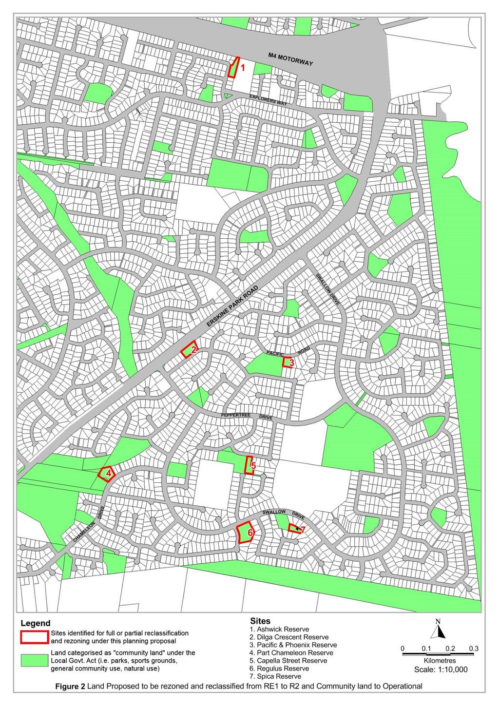
27 Table 3 Land proposed to be reclassified and rezoned Site Address Legal Description Site 1: Regulus Reserve 73 Swallow Drive, Lot 3280 DP Erskine Park Site 2: Dilga 9A Dilga Crescent, Crescent Reserve Erskine Park Lot 148 DP Site3: Pacific and Phoenix Reserve (part) 27A Phoenix Crescent, Erskine Park Lot 1444 DP Site 4: Capella Street 11A Canopus Close, Reserve (part) Erskine Park Lot 2174 DP Site 5: Spica Reserve (part) Site 6: Chameleon Drive (part) 85 Swallow Drive, Erskine Park 25 Chameleon Drive, Erskine Park Lot 3281, DP Lot 1106 DP Erskine Park Site 7: Ashwick Reserve 11 Ashwick Circuit, St Clair Lot 35 DP A detailed breakdown of the current and proposed LEP planning controls for each site is provided at Appendix F. 2.2 PART 2 - EXPLANATION OF PROVISIONS This Planning Proposal recommends amendments to LEP 2010 to reclassify and rezone land within Erskine Park. The following amendments to LEP 2010 are proposed: Reclassify subject land identified in blue on Figure 2 from Community land to Operational land. Inclusion of the subject land into Schedule 4 Classification and reclassification of public land, specifically listing the land in Part 2 Land classified, or reclassified, as operational land interests changed. Table 4 below outlines the proposed amendments to Schedule 4 Classification and reclassification of public land. Rezone subject land identified on map currently zoned as RE1 Public Open Space to R2 Low Density Residential Amend the Land Zoning Map, Height of Buildings Map and Lot Size Map to reflect the development parameters surrounding the subject land. Generally, each site is proposed to either be completely or partially amended to have a zoning of R2 Low Density Residential with maximum building height of 8.5 metres and minimum lot size of 550m 2. The above amendments to the LEP 2010 are expected to deliver approximately 21 new 27
28 dwellings on the seven sites affected. The Draft Open Space Strategic Masterplan (Draft OSMP) prepared by Clouston Associates provides an indicative subdivision pattern across each of the land parcels the subject of this Planning Proposal. It is expected that an individual dwelling will be provided on the majority of these lots, except three lots which are capable of accommodating dual occupancy dwellings (two dwellings per lot). Spica Reserve is also expected to be subdivided in a manner which provides opportunities for surrounding lots to increase in size rather than any new additional lots. As such, no new dwellings are expected on the portion of Spica Reserve the subject of this proposal. The OSMP (refer to Appendix D) is to be publicly exhibited concurrently with this Planning Proposal. A description of the subject land, and interests Council has in this land (easements, etc.) to be changed, is provided in Table 4 below, whilst the location of the subject land is illustrated in Figure 2. Table 4 Proposed amendments to Schedule 4 Classification and reclassification of public land Site Address Legal description Erskine Park Trusts, Easements and Interests Trusts / Interests Discharged Future Intentions for the sites Site 1: Regulus Reserve 73 Swallow Drive, Erskine Park Lot 3280 DP Public Reserve Easement to drain water Yes No Council intends to dispose of its asset within 6 months or as soon as is practicable upon rezoning/reclassification to ensure the community receives the benefit of the proceeds as quickly as possible. Site 2: Dilga Crescent Reserve 9A Dilga Crescent, Erskine Park Lot 148 DP Public Reserve Easements for underground mains and electricity purposes Yes No Council intends to dispose of its asset within 6 months or as soon as is practicable upon rezoning/reclassification to ensure the community receives the benefit of the proceeds as quickly as possible. Site 3: Pacific and Phoenix Reserve (part) 27A Phoenix Crescent, Erskine Park Lot 1444 DP Public Reserve Yes Council intends to dispose of its asset within 6 months or as soon as is practicable upon rezoning/reclassification to ensure that community receives the benefit of the proceeds as quickly as 28
29 Site 4: Capella Street Reserve (part) Site 5: Spica Reserve (part) Site 6: Chameleon Reserve (part) St Clair 11A Canopus Close, Erskine Park 85 Swallow Drive, Erskine Park 25 Chameleon Drive, Erskine Park Lot 2174 DP Lot 3281 DP Lot 1106 DP possible. Public Reserve Yes Council intends to dispose of its asset within 6 months or as soon as is practicable upon rezoning/reclassification to ensure the community receives the benefit of the proceeds as quickly as possible. Public Reserve Yes Council intends to dispose of its asset within Easement to drain No 6 months or as soon as is water practicable upon rezoning/reclassification to ensure the community receives the benefit of the proceeds as quickly as possible. Public Reserve Easements for underground mains and electricity purposes Yes No Council intends to dispose of its asset within 6 months or as soon as is practicable upon rezoning/reclassification to ensure the community receives the benefit of the proceeds as quickly as possible. Site 7: Ashwick Reserve 11 Ashwick Circuit, St Clair Lot 35 DP Drainage Reserve Easements to drain water Covenant requiring consent for access to or from the motorway Yes No No Council intends to dispose of its asset within 6 months or as soon as is practicable upon rezoning/reclassification to ensure the community receives the benefit of the proceeds as quickly as possible. Fencing Restriction Yes 29
30 30
31 3.0 JUSTIFICATION (PART 3) 3.1 SECTIONS TO BE ADDRESSED Part 3 of the Planning Proposal is divided into the following subsections: Section A - Need for the Planning Proposal (see 3.2 below) Section B - Consistency with Strategic and Statutory Planning Framework (see 4.0 below) Section C - Environmental, Social and Economic Impacts (see 5.0 below) Section D - State and Commonwealth Interests (see 6.0 below) 3.2 SECTION A - NEED FOR THE PLANNING PROPOSAL As outlined in Section 1.0, it has been identified that Erskine Park and St Clair have greater physical areas of open space available than is required to meet the needs of residents. However, the quality and variety of open space is not appropriate, so ensuring reinvestment through rezoning and reclassification and the sale of selected parcels is necessary. Through extensive studies, it has also been determined that there are opportunities for existing open spaces to be enhanced to better service the community and increase the enjoyment of these spaces for residents and visitors. The most appropriate method of rezoning and reclassifying the land is through the planning proposal process. The planning proposal process is open, transparent and provides a rigorous framework for the merits of the proposal to be assessed. Q1 Is the Planning Proposal the result of any strategic study or report? Numerous Council led studies have informed the current Planning Proposal, and specifically the subject sites which are proposed to be rezoned and reclassified. The need for this Planning Proposal was highlighted in: 1. Community engagement; and 2. Previous studies (refer Figure 1). Before making any formal decisions on whether any land parcels could be sold, Council carried out two stages of community consultation to identify community needs and identify which land parcels could be sold. Further details of the community consultation undertaken to date are described in Part 5 and in the Consultation Report provided at Appendix E. 31
32 People s Lifestyle Aspiration and Needs Study (PLANS) PLANS was informed by an assessment of the community s needs and aspirations to establish plans and strategies to preserve and enhance quality of life of residents in the Penrith LGA. PLANS contains a series of objectives that seek to rationalise small and underutilised parks (objective 2.2) and provide high quality open space. The study identifies the need to progressively build upon the existing network of local and regional walking and cycling paths (objective 3.2) and improve public accessibility to open space for all members of the public. Overall, the PLANS identifies a focus on: the need to consider the quality of open space (rather than just the quantity) through larger and more accessible areas that cater for different age groups and interests; and the importance of social inclusion and accessible design factors in the planning and design of open space. The Planning Proposal is the result of the PLANS as it seeks to consolidate the surplus areas of open space into higher quality and more usable and accessible spaces. Open Space Action Plan The Open Space Action Plan 2007 identifies Council s open space land holdings and outlines the strategies and actions for the future aims of this land. The Open Space Action Plan implements the broad findings of the PLANS into a more direct plan that provides a more detailed assessment of specific open space reserves throughout Penrith. The plan identifies the land holdings in Erskine Park and St Clair as primarily comprising pocket parks and linear drainage spaces. The plan identifies that improving the quality of the City s open space areas and facilities will involve a review of the merit of smaller open space areas, particularly where there are a variety of existing parks and open space to meet local community needs. The Planning Proposal supports this aim as it seeks to rationalise the high number of pocket parks in Erskine Park and St Clair to reduce maintenance expenditure and improve the quality of other parks and reserves that are fit for purpose. The proposal facilitates the Open Space Action Plan objective to Facilitate Diverse Recreational & Cultural Program Development (Objective 5). The proposal will improve the desirability of parks and reserves by improving accessibility and the range of facilities in parks to encourage their use by all members of the community. The improvements to existing parks which will be facilitated through the proposal will ensure there are greater opportunities for diverse recreational pursuits to be satisfied. Draft Open Space Master Plan The information collected during the consultation program, along with technical studies commissioned by Council then informed the development of a draft Open Space Master Plan (OSMP). The draft OSMP identifies specific sites where improvements could be made, the types of upgrades and facilities needed, and which underutilised spaces might be sold to fund improvements. The draft OSMP is intended to be concurrently exhibited with this Planning Proposal. Given the status of the subject land within Erskine Park, being land purchased utilising section 94 funds, all proceeds from the sale of these 32
33 land parcels will be directed towards upgrading open space/recreational infrastructure in Erskine Park. The draft OSMP provides the strategic framework for the management and improvement of open space in Erskine Park for the next 5-10 years and establishes the following objectives that align with the objectives and intended outcomes of this Planning Proposal: 1. increase the amenity of existing open space and its recreational offering; 2. ensure equitable access to open space and recreation infrastructure for all residents; and 3. provide a delivery framework that ensures investment in open space and recreational infrastructure is well targeted to meet the community s needs. The draft OSMP identifies a number of existing parks that are no longer fit for purpose and outlines the way that revenue generated from their sale may be used to provide public domain improvements including: A review of lighting, particularly along pedestrian and cycle paths to ensure that existing facilities are able to be used safely; Additional street tree planting to improve year round interest in open space and improve amenity factors such as sun shading; Road corridor infrastructure improvements including upgrades to bus stops, paving, lighting, seating, shade and weather protection; and The implementation of an Active Movement Network which includes the installation of a continuous footpath along the Swallow Drive and Peppertree Drive loop as a high priority. In addition to the general recommendations for public domain upgrades, the Draft OSMP identifies specific upgrade works to a number of reserves to which this proposal applies. These sites include: Spica Reserve; Capella Reserve; and Phoenix and Pacific Reserve. Further details of the recommendations for public domain upgrades are provided in the Draft OSMP. Given the status of the subject land within Erskine Park, being land purchased utilising section 94 funds, all proceeds from the sale of these land parcels will be directed towards upgrading open space/recreational infrastructure in Erskine Park. Council currently owns 19 parks and reserves in Erskine Park and provides approximately 30% more open space than the widely accepted standard for the provision of local open space within an urban context 1. Overall, approximately 26 hectares of open space is available in Erskine Park. All parks/reserves in Erskine Park were acquired by Council as a form of local infrastructure contribution in the 1980s-90s. A number of these parks 1 A standard of 2.83 hectares/1000 people is generally adopted as the required amount of open space in new release areas (referenced in the People s Lifestyle Aspiration and Needs Study p.iii) 33
34 can be classified as small, isolated, irregularly shaped and in close proximity to one another. The parcel of land in St Clair the subject of this proposal was originally designated as open space for drainage purposes. It has been identified by Council that these reserves are no longer needed for drainage purposes and therefore are surplus. Q2 Is the Planning Proposal the best means of achieving the objectives or intended outcomes, or is there a better way? Council owns a large amount of open space in Erskine Park. The suggested improvements to a number of Erskine Park reserves are not currently prioritised within Council s existing asset renewal program. The asset renewal program aims to replace what is currently provided, not to create new facilities. Council has been receiving requests from the communities over a number of years from residents in established areas for the types of recreational offerings provided in newer release areas. These improvements could not be achieved within Council s current available funds however are made possible by the sale of surplus open space. This Planning Proposal is the best means of achieving the stated objectives and intended outcome. To facilitate the sale of surplus land within Erskine Park and St Clair, the subject land is required to be rezoned and reclassified. As outlined in Section 1.0, Community land has a number of restrictions and cannot be leased, licensed or any other estate granted over the land for more than 21 years, and may only be leased or licensed for more than 5 years if public notice of the proposed lease or licence is given. As no such restrictions apply to operational land, this Planning Proposal is the best means of reclassifying and rezoning the land to facilitate its sale and development. 34
35 4.0 SECTION B - RELATIONSHIP TO STRATEGIC AND STATUTORY PLANNING FRAMEWORK Q3 Is the Planning Proposal consistent with the objectives and actions of the applicable regional or sub-regional strategy (including the Sydney Metropolitan Strategy and exhibited draft strategies)? NSW Government s Framework - Metropolitan and Subregional Plans The current metropolitan plan for Sydney, A Plan for Growing Sydney provides a high level strategic framework for managing the growth of Sydney, which is relevant to the Planning Proposal. The plan establishes four key goals for Sydney: 1. A competitive economy with world-class services and transport; 2. A city of housing choice, with homes that meet our needs and lifestyles; 3. A great place to live with communities that are strong, healthy and well connected; and 4. A sustainable and resilient city that protects the natural environment and has a balanced approach to the use of land and resources. The proposal is consistent with these goals as it seeks to provide Council with the opportunity to increase funding to improve the quality of existing areas of open space to better serve the community. The reclassification of the subject land parcels will permit minor residential growth in areas that are appropriately located in close proximity to open space, transport and services. The proposal will also enable greater housing choice and the improvement of open space to meet the lifestyle choices and needs of existing and future residents in Erskine Park and St Clair. The open space improvements facilitated by the proposed rezoning and reclassification of the land parcels will ensure the Erskine Park and St Clair communities become stronger, healthier and more well connected through improved access to high quality open space and enhanced pedestrian/cycleway networks. Specifically, the Planning Proposal will facilitate the achievement of Direction 3.2 of the plan, to create a network of interlinked, multi-purpose open and green spaces across Sydney. The Direction identifies the need to establish appropriate planning for the open space needs of the community. This Planning Proposal will achieve this aim as it will address the practical recreational and open space needs of the community that have been determined in consultation with local residents. The Planning Proposal is also consistent with Direction 3.3 of the plan, which aims to create healthy built environments as it will facilitate funding that will be used to deliver infrastructure such as outdoor fitness equipment, improved access to parks through shared paths and improved public transport facilities that are located in close proximity to recreation areas. 35
36 As outlined in Section 5.1, the rezoning and reclassification will not result in any significant adverse environmental impacts and will support a sustainable and balanced approach to providing a mix or housing and open space. The land to which this proposal applies is located in the Western Subregion under A Plan for Growing Sydney. The priorities for the subregion are: 36
37 A competitive economy. Accelerate housing supply, choice and affordability and build great places to live. Protect the natural environment and promote its sustainability and resilience. The rezoning and reclassification is consistent with these priorities as it seeks to increase the supply of housing in appropriate locations close to public transport, open space and services by generating approximately 21 new dwellings across the 7 sites. The proposal will increase the supply of housing in an area located in close proximity to the Western Sydney Employment Area, identified under A Plan for Growing Sydney, and will result in an improvement in the quality of existing open space in the area. The sites are also located close to the Western Sydney Parklands. The parklands provide a continual stretch of parkland from Leppington to Quakers Hill and provide significant entertainment and recreation facilities including the Sydney International Equestrian Centre and the Blacktown Olympic Park. The parklands will offer significant open space and recreational facilities to the Erskine Park and St Clair areas. The proposal will also assist, to a minor degree in the acceleration of housing supply, choice and affordability while creating great places to live. Consistent with Council s endorsed Cooling the City Strategy, tree planting and landscaping is planned in many of the reserves identified for improvement to mitigate against the Urban Heat Island Effect. More broadly, street tree planting is proposed as part of the public domain improvements in Erskine Park. An inevitable consequence of urban infill development is that a limited number of trees can be retained on development sites. However, where possible, it is recommended that significant trees be retained or alternative solutions be developed to ensure the landscape character of the locality is not adversely impacted. Q4 Is the Planning Proposal consistent with Council s local strategy or other local strategic plan? Council s Framework Strategic Planning Council s strategic planning framework consists of the following documents: Community Plan Community Engagement Strategy Delivery Program (including the one year Operational Plan) Resourcing Strategy City Strategy The documents of most relevance for this Planning Proposal are the Community Plan, the Delivery Program (including the one year Operational Plan), and the City Strategy. 37
38 The Community Plan identifies our communities long term aspirations for Penrith City, setting Outcomes and Strategies. Appendix F examines the consistency of this Planning Proposal with the outcomes and strategies, demonstrating that the Planning Proposal is consistent with the Community Plan. The Delivery Program (including the one year Operational Plan) is Council s 4 year work program, identifying Priorities to help implement the Community Plan. The Priorities for include: More local jobs; and Making sure that services and infrastructure are adequate. Given these priorities, Council has the following focuses: focussing on investment and growth in the City s key centres, Penrith Health and Education Precinct and Western Sydney Employment Area; creating opportunities for activities on and around the Nepean River; advocating for a stadium that is capable of hosting national and international events (entertainment and sport); and working with government to secure the Penrith Lakes Parklands and participate in unlocking future development potential. The reclassification of the subject land will provide Council with the ability to trade, lease or develop the land, allowing Council to utilise its property portfolio to manage its finances responsibly and improve the quality of local open space. The Planning Proposal is generally consistent with the relevant local strategies of Council and the relevant Penrith strategic plans as outlined below. Council s Framework Local Planning Documents All parcels intended to be rezoned as part of this pilot project in Erskine Park are proposed to be given a R2 Low Density Residential zone. The planning objective of the R2 zone is to protect the locality's single dwelling character and the application of this zone will ensure that the established character of development in the area is maintained. Council has also published detailed development controls to promote appropriate residential housing design and to stimulate a vibrant streetscape. The future development on these sites is expected to be generally consistent with these detailed development controls. NSW Government s Framework - Local Planning Directions and State Environmental Planning Policies The Minister for Planning and Environment issues Local Planning Directions that Councils must follow when preparing a Planning Proposal. The directions cover the following broad categories: Employment and resources; Environment and heritage; Housing, infrastructure and urban development; Hazard and risk; Regional planning; and Local plan making. 38
39 The NSW Government also publishes State Environmental Planning Policies. These documents deal with matters of State or regional planning significance. This Planning Proposal is considered to be consistent with all applicable Local Planning Directions and relevant State Environmental Planning Policies. Appendix G and Appendix H examine the consistency of this Planning Proposal with these documents. NSW Government s Framework LEP Practice Note The Department of Planning and Environment has also published LEP Practice Note relating to the Classification and reclassification of public land through a local environmental plan. This practice note provides guidance on the process to classify or reclassify public land through a local environmental plan, including the level of information Council must provide in this Planning Proposal (provided at Appendix G). Table 5 also sets out where the information is provided or provides a succinct response. Table 5 Information required by Practice Note No Information Where Addressed/Response 1 The reasons why the planning proposal Throughout has been prepared, including the merits of the Proposal. 2 The current and proposed classification Appendix I of the land. 3 The reasons for the reclassification Section Justification including how this relates to Council s Section Relationship strategic framework. to Strategic Planning Framework 4 The nature of council s interest in the Appendix I land 5 How and when the interest was first Appendix I acquired 6 The reasons council acquired an Appendix I interest in the land. 7 Any agreements over the land together Appendix I with their duration, terms, controls, agreement to dispose of the land. 8 An indication, as a minimum, of the magnitude of any financial gain or loss from the reclassification and of the type(s) of benefit that could arise. 9 The asset management objectives being pursued, the manner in which they will be achieved and the type of benefits the council wants. 10 Whether there has been an agreement for the sale or lease of the land. 11 Relevant matters required in plan making under the EP&A Act. There will be no financial gain or loss as a consequence of the reclassification. The type of financial benefit that could arise would occur if the land was sold to another party. Throughout There has not been an agreement for the sale or lease of the land. Council intends to realise its assets following the reclassification of the land. Throughout 39
40 Penrith Local Environmental Plan 2010 The proposal is consistent with the aims of the Penrith LEP 2010, as outlined in Table 6 below. Table 6 Consistency with LEP aims LEP Aims (a) to provide the mechanism and planning framework for the management, orderly and economic development, and conservation of land in Penrith, (b) to promote development that is consistent with the Council s vision for Penrith, namely, one of a sustainable and prosperous region with harmony of urban and rural qualities and with a strong commitment to healthy and safe communities and environmental protection and enhancement, (c) to accommodate and support Penrith s future population growth by providing a diversity of housing types, in areas well located with regard to services, facilities and transport, that meet the current and emerging needs of Penrith s communities and safeguard residential amenity, (d) to foster viable employment, transport, education, agricultural production and future investment opportunities and recreational activities that are suitable for the needs and skills of residents, the workforce and visitors, allowing Penrith to fulfil its role as a regional city in the Sydney Metropolitan Region, (e) to reinforce Penrith s urban growth limits by allowing rural living opportunities where they will promote the intrinsic rural values and functions of Penrith s rural lands and the social well-being of its rural communities, Comment The Planning Proposal will facilitate the orderly and economic development of surplus land in Penrith while maintaining a sufficient amount of open space for the local community that will be upgraded to improve its usability and accessibility. The Planning Proposal will facilitate additional housing of a type and density that is commensurate with that of the surrounding land. The proposal will provide for the improvement and upgrade of various parks and reserves in the Erskine Park and St Clair localities and will assist in achieving the Council s vision. The proposal will facilitate a range of additional housing types in areas appropriately located in close proximity to open space, transport and services. The proposed divestment of open space will ensure that only surplus land is provided to support Penrith s future population. Additional housing will be provided in close proximity to transport, open space, services and will be commensurate with that of the existing surrounding residential character. The proposal will improve recreation facilities by improving the quality, diversity, accessibility and range of recreational facilities in the locality. The upgrades to open space will be provided to meet the needs of the local residents, workforce and visitors. While the proposal doesn t facilitate rural living, it will improve the range and diversity of dwelling types in a residential locality and will maintain the existing residential character of the locality. 40
41 LEP Aims (f) to protect and enhance the environmental values and heritage of Penrith, including places of historical, aesthetic, architectural, natural, cultural, visual and Aboriginal significance, (g) to minimise the risk to the community in areas subject to environmental hazards, particularly flooding and bushfire, by managing development in sensitive areas, (h) to ensure that development incorporates the principles of sustainable development through the delivery of balanced social, economic and environmental outcomes, and that development is designed in a way that assists in reducing and adapting to the likely impacts of climate change. Comment The proposal will not adversely impact on the significance of any items or land of heritage significance. The proposal will not have any significant adverse impacts on flooding or bushfire management and will facilitate the improvement of environmental maintenance. The proposal will achieve a balance between environmental, social and economic outcomes by utilising surplus land to provide additional and diverse housing types while improving the accessibility, quality and diversity of open space. Relationship to Section 94 Contributions Plans As previously stated, the land identified in this Planning Proposal for divestment is surplus to Council s needs. All of the reserves located in Erskine Park identified for whole or partial divestment in this proposal were originally acquired by Council through Section 94 contributions or under contributions plans that have since been repealed. Accordingly, all revenue generated through the rezoning and sale of the land is to be allocated towards open space upgrades within Erskine Park. Council currently owns 19 parks and reserves in Erskine Park and provides approximately 30% more open space than the widely accepted standard for the provision of local open space within an urban context 2. Overall, approximately 26 hectares of open space is available in Erskine Park. A number of the reserves to be partially retained are identified for upgrade works under the Penrith City Local Open Space Development Contribution Plan (s94). The upgrade works for each of these parks is outlined below: Pacific and Phoenix Reserve - Provide playground equipment and park furniture; Capella Street - Provide pathway from Capella Street to Canopus Close Spica Reserve - Provide playground equipment and park furniture; and Chameleon Drive Reserve - Provide landscaping and park furniture The sale of the land identified in this Planning Proposal will facilitate the provision and upgrade of these facilities in addition to the allocation of any section 94 funds. Overall the disposal and sale of the reserves will provide additional funds that will directly facilitate the upgrade and improvement of the open space in Erskine Park. The Proposal is consistent with the various S94 contributions plans in this regard. 2 A standard of 2.83 hectares/1000 people is generally adopted as the required amount of open space in new release areas (referenced in the People s Lifestyle Aspiration and Needs Study p. iii) 41
42 Q5 Is the Planning Proposal consistent with applicable State Environmental Planning Policies? An assessment of the Planning Proposal against the applicable State Environmental Planning Policies (SEPPs) is set out in Appendix H. Q6 Is the Planning Proposal consistent with applicable Ministerial Directions (s.117 directions)? An assessment of the Planning Proposal against the applicable Section 117 directions is set out in Appendix H. Relationship with the Greater Sydney Commission Draft West District Plan The Planning Proposal has been assessed against the draft Greater Sydney Commission West District Plan and found to be consistent. A statement on the review and a response by the Department of Planning is detailed below. At the time of exhibition of Planning Proposal the Greater Sydney Commission has released the Draft West District Plan for public comment. Information Note 6 accompanying release of the draft Plan states: What is the process for planning proposals that are yet to be exhibited? The relevant planning authority should consider planning proposals that are yet to be exhibited against the draft District Plans to see if an amendment may be required. The relevant planning authority should discuss any proposed changes with the Department of Planning and Environment s relevant regional team to determine if any change is required to the Gateway Determination. In accordance with Note 6, the Erskine Park Planning Proposal has been assessed against the draft West District Plan, most relevantly sections 4.6 and sections 4.7 (as outlined below) and that review referred to the Department of Planning and Environment for review. The results are presented below: Sections of the West District Plan relevant to the Erskine Park Planning Proposal 4.6 Create Great Places in the West District: Improving amenities Create healthy, well designed, safe and inclusive places that encourage economic and social activity, vibrancy and community spirit Provide the kind of places and facilities that help build a more cohesive community Better Places Seven Principles, notably relevant being: Functional, responsive, fit for purpose Enhance walking and cycling Create opportunities for more recreation and community facilities 42
43 Consideration of the Planning Proposal against the relevant GSC draft West District Plan provisions: The Erskine Park Planning Proposal seeks to rezone and reclassify 7 sites in Erskine Park and St Clair which are no longer required for the purposes for which they were identified several decades ago. Recent recreation, drainage and community facility needs studies and reviews by Council (and provided with the PP) have confirmed the sites are no longer required for these purposes. The rezoning and reclassification of these 7 sites - and any eventual sale of these properties by Council - will permit minor additional housing, but most relevantly to the GSC draft West District Plan provisions, permit reinvestment of all moneys raised into the improvement of recreation and community facilities in Erskine Park. Recreation studies and management plans have identified a range of new facilities on specific sites that will be embellished, including: shared pathways/cycleways, footpaths (connecting the community to facilities and each other while enhancing recreation offerings); embellished local parks to increase the range and quality of facilities on offer and create magnetic places for the community to visit and congregate; functional, fit for purpose parks which are well designed and, through increased visitation, enhance vibrancy, social activity and community spirit; park and recreation designs which draw on local character and local needs to augment strengths and address any limitations; and significant additional landscaping to enhance amenity and appeal of parks and streets across Erskine Park. Submission to DP&E for review and response: In accordance with item 2 in the Greater Sydney Commission Note 6 requirements listed above, on 13 January 2017 this review against the West District Plan was submitted to the DP&E for consideration and instruction as to whether any change is required to the Gateway Determination. In response to the review, on 16 January 2016 the DP&E Sydney Region West Office advised as follows: Thank you for sending through this information. The explanation provided above should be placed and contained within the proposal itself. Given this assessment has not led to any other changes to the proposal, an alteration of the Gateway determination is not required. In accordance with the Department s instruction above, the review against the Draft West District Plan by the greater Sydney Commission is incorporated in this Planning Proposal. 43
44 5.0 SECTION C - ENVIRONMENTAL, SOCIAL AND ECONOMIC IMPACTS 5.1 ENVIRONMENTAL IMPACTS Q7 Is there any likelihood that critical habitat, threatened species, populations or ecological communities, or their habitats, will be adversely affected as a result of the proposal? The land is not identified on the Natural Resources Sensitive Land Map in Penrith LEP The landscape significance of the existing trees is recognised by the Scenic and Landscape Values Map and associated provisions in LEP This Planning Proposal does not recommend any amendment of this map or provisions, which will continue to apply to the land. The provisions require any new development to be located and designed to minimise its visual impact. DCP 2014 also provides detailed development controls for the preservation of trees and vegetation. The subsequent development of the land may help manage existing environmental impacts and respond to a changing climate by planting trees and vegetation in more strategically located areas. Public domain improvements will include improved street tree planting, green walls, shade structures and water, which will contribute positively to the cooling of Erskine Park. There are no known items or sites of European or Aboriginal cultural heritage that would be affected by the proposal. Council will consult with the Aboriginal Land Council as part of the Planning Proposal process. Q8 Are there any other likely environmental effects as a result of the Planning Proposal and how are they proposed to be managed? This Planning Proposal does not recommend the amendment of those provisions in the LEP 2010 that require new development to identify and manage its environmental impacts, such as the preservation of trees and vegetation and the management of stormwater. These provisions will continue to apply to the land. Other potential environmental effects of the proposed reclassification and rezoning to low density residential uses are explored below Arboriculture Assessment A Preliminary Arboriculture Assessment of the existing vegetation on the subject land parcels has been prepared by Glenyss Laws Consulting Arborist and is provided at Appendix J. The Preliminary Arboriculture Assessment identifies that a number of the sites contain the following endangered or threatened communities: Cumberland Plain Woodland a Critically Endangered Ecological Community under the Environment Protection and Biodiversity 44
45 Conservation Act 1999 (EPBC Act). Shale Gravel Transition Forrest an Endangered Ecological Community under the Threatened Species Conservation Act 1995 (TSC Act) and a Critically Endangered Ecological Community under the EPBC Act. 45
46 Glenyss Laws Consulting Arborist identifies that in a number of instances the Eucalyptus Tereticornis (Cumberland Plain Woodland) contained with the land parcels are dead, or over mature and reaching the end of their useful life expectancy. As such, removal of these trees is recommended and will not be of concern in the future development of the sites for residential dwellings. Where trees are to be removed in the future, it is recommended that a proactive policy of replacement is adopted. A number of trees surveyed across the land parcels were noted as being poorly maintained and therefore their condition rigour and retention value are low. This appears to be due, in part, to the large number of smaller and fragmented open space in Erskine Park and St Clair and the sparse allocation of resources able to be provided to each reserve. Table 7 below outlines the observation of each site, identifying the number of trees, the number recommended to be retained and comments on the existing trees. Table 7 Summary of vegetation on the site Site Regulus Reserve Dilga Reserve Pacific and Phoenix Reserve (part) Capella Street Reserve (part) No. of trees Priority for retention 13 trees and three copses of planted trees Comment 3 Nine trees identified as dominant species in the Cumberland Plain Woodland group Four trees are dead, two trees are in irreversible decline and six trees are over mature and have a short useful life expectancy trees identified as the dominant species in Cumberland Plain Woodland group 11 trees have a short useful life expectancy and one tree is dead trees associated with Cumberland Plain Woodland group One of the six trees associated with Cumberland Plain Woodland group may provide suitable habitat for native wildlife which will need to be further investigated The remaining trees are non-local specimens and are recommended for removal 20 1 Poor maintenance has resulted in borer infestation and a reduction in overall condition rigour and retention value for the majority of trees 46
47 Site Spica Reserve (part) Chameleon Drive (part) Ashwick Reserve No. of trees Priority for retention Comment 19 0 Poor maintenance has resulted in borer infestation and a reduction in overall condition rigour and retention value 2 trees appear to be associated with the Cumberland Plain Woodland group, however are over mature and have a short useful life expectancy One tree outside of the subject land is a remnant Cumberland Plane Woodland specimen. A Tree Protection Zone (TPZ) is recommended in the detailed design phase of any new development. - - No trees are located on the subject land, however a number are located in close proximity and may be affected by future development. TPZs are recommended in the detailed design phase of any new development. Each of the trees identified on the land parcels are subject to a Tree Preservation Order imposed by Penrith Council under Clause 5.9 of the Penrith LEP This Clause requires the granting of Development Consent or a Permit Issued by Council for the removal of trees. Therefore, at the relevant stage of the development process, approval would need to be granted from Council for the removal of any trees. The Preliminary Arboriculture Assessment recommends that the future development of the sites should be accompanied by a Tree Protection Plan and a more Detailed Arboriculture Assessment to assess impacts on the trees or the removal of trees. This detailed assessment must consider whether it is appropriate for particular trees to be removed and if necessary, specify if any mitigation or management measures are required following further investigations. Notwithstanding this future requirement, the Preliminary Arboriculture Assessment finds that the exiting trees and vegetation located on the site will not prevent the reclassification and rezoning of the land for residential development as the reclassification and rezoning would not result in any significant adverse impacts on the existing vegetation. The detailed design of the dwellings and subdivision allotments on the subject land parcels will be required to respond to the location of the trees and incorporate any removal if this is supported by an ecological assessment. 47
48 5.1.2 Ecology An ecological due diligence assessment has been prepared by Eco Logical Australia (Appendix M) to assess the ecological value and development constraints for the relevant reserves identified in this Planning Proposal. The assessment included a site survey and desktop review of potential flora and fauna that may occupy the sites. Ashwick and Capella reserves were not included in the ecological assessment for the following reasons: Ashwick: The reserve does not contain any trees hence there are no ecological constraints on the site. This is confirmed in the Arboriculture Assessment; and Capella: the portion of the site identified for disposal includes a fragmented stand of trees in a poor condition. Poor maintenance practices have resulted in borer infestation and a reduction in overall condition, vigour and retention value. The assessment confirms that Shale Plane Woodland of the Cumberland Plane Woodland vegetation type is mapped across all of the sites considered in the assessment. Notwithstanding this, the assessment considers that all of the sites are suitable for rezoning as much of the vegetation observed is in a poor condition that would not meet listing criteria as a threatened species. Should the removal of trees be required during the development stage, it is not expected this will have any significant adverse impacts on the local occurrence or significance of any threatened species. Table 8 sets out commentary provided by Eco Logical on each site. Table 8 Summary of ecology observations Site Dilga Reserve The site contains a stand of remnant vegetation that forms part of the Shale Plains Woodland, a sub-community of Cumberland Plain Woodland. The general health of the trees is considered to be poor and would not meet the criteria for listing under the EPBC Act. Removal of the vegetation would be unlikely to have a significant impact on the occurrence of CPW. No threatened fauna species have been observed on the site and the fauna habitat is generally poor however some vegetation may provide potential roosting and foraging habitat. Eco Logical consider that the vegetation within the reserve is in generally poor health with poor long term viability, accordingly the reserve is recommended for urban development. 48
49 Site Regulus Reserve Pacific and Phoenix Reserve (part) Spica Reserve (part) Chameleon Drive (part) Comment The site contains a number of exotic ground cover species and a large remnant Grey Box, being a part of the Shale Plains Woodland, a sub-community of the CPW. The general health of the trees is considered to be poor and would not meet the criteria for listing under the EPBC Act. Removal of the vegetation would be unlikely to have a significant impact on the occurrence of CPW. Habitat for fauna is generally limited, however roosting and foraging vegetation is present that may be inhabited by threatened species. Eco Logical consider that the biodiversity value of the site is relatively low given the small area of CPW is unlikely to provide connectivity at a regional scale. Accordingly rezoning of the site is unlikely to facilitate development that will have a significant impact on CPW. The part of the site identified for disposal contains a number of exotic and non-local species as well as a Grey Box and Red Gum, being a part of the Shale Planes Woodland, a sub-community of the CPW. The general health of the trees is considered to be poor and would not meet the criteria for listing under the EPBC Act. Removal of the vegetation would be unlikely to have a significant impact on the occurrence of CPW. Habitat for fauna is generally limited, however roosting and foraging vegetation is present that may be habited by threatened species. Eco Logical consider that the biodiversity value of the site is relatively low given the small area of CPW is unlikely to provide connectivity at a regional scale. Accordingly rezoning of the site is unlikely to facilitate development that that will have a significant impact on CPW. The part of the site identified for disposal contains exotic ground covers and shrubs with three large remnant Grey Box, being a part of the Shale Planes Woodland, a subcommunity of the CPW. The general health of the trees is considered to be poor and would not meet the criteria for listing under the EPBC Act. Removal of the vegetation would be unlikely to have a significant impact on the occurrence of CPW. Habitat for fauna is generally limited however roosting and foraging vegetation is present that may be habited by threatened species. Eco Logical consider that only three remnant significant trees are on the site with all other vegetation planted. Accordingly, the site is recommended to be rezoned for residential development. The part of the site identified for disposal contains exotic ground covers and shrubs with no CPW observed. Habitat for fauna is generally limited with the young age of vegetation being unlikely to habit threatened fauna. Eco Logical consider that the site does not contain any threatened species and as such no assessment is required. 49
50 Eco Logical confirm that the rezoning of all sites is suitable as the long term viability of the Cumberland Plain Woodland is poor with no natural recruitment, isolated vegetation and any restoration would require extensive planting and weeding. The health of a number of the trees was poor and as such presents limited opportunities for threatened fauna species, although there is some potential for roosting and foraging. Due to the highly mobile nature of the species expected to occur on the site, the rezoning of the land is not anticipated to have any significant impacts on the long term survival of these species Traffic and Parking Assessment The rezoning and reclassification of land parcels sought as part of the Planning Proposal will have limited potential environmental impacts. One key consideration which has been assessed in a preliminary manner is traffic and parking impacts as a result of potential future residential development. A Traffic and Parking Assessment has been prepared by Parking and Traffic Consultants (Appendix K) to assess the potential future traffic impacts resulting from the rezoning and reclassification of the sites. The Assessment identifies the indicative number of dwellings to be constructed on each site and determines the existing and future capacity of the local road network to accommodate the anticipated increase in traffic. The assessment considers the existing road network in the locality of the site which includes State arterial roads such as the M4 Western Motorway and Erskine Park Road as well as the various local roads and traffic conditions on these roads. The RMS Guide to Traffic Generating Developments Updated Surveys Technical Direction has been adopted to anticipate the future traffic generation rates of the expected residential development. The Assessment conservatively adopts the maximum RMS rate of 1.39 vehicle trips per hour in morning peak times and 1.32 vehicle trips per hour in afternoon peak times. Table 9 below provides a summary of the proposed number of dwellings and parking, traffic and access implications associated with those dwellings. Table 9 Summary of dwellings, parking and traffic implications Site Regulus Reserve Dilga Reserve No of Dwellings 6 (four dwellings and 2 dual occupancy) AM trips PM Trips Parking allocation Access and sightlines Access location is suitable. Sightlines and grades to be resolved during design stage Access location is suitable Access is recommended to not be provided to Erskine Park Road. 50
51 Site Pacific and Phoenix Reserve (part) Capella Street Reserve (part) Chameleon Reserve (part) Ashwick Reserve No of Dwellings AM trips PM Trips Parking allocation Access and sightlines Access location is suitable Access location is suitable Access width to battle-axe lots to be considered during design Access location is suitable Access width to battle-axe lots to be considered during design 2 (dual occupancy) Access location is suitable Based on the above, the traffic generated from each dwelling will result in an increase in the number of vehicles using three local roads and at their intersection with Erskine Park Road, as follows: Swallow Drive/Erskine Park Road intersection increase of four vehicular trips in the AM and PM peak Peppertree Drive/Erskine Park Road intersection increase of 31 vehicular trips in the AM peak and 29 vehicular trips in the PM peak. Explorer Way/Erskine Park Road intersection increase of 6 vehicular trips in the AM peak and 5 vehicular trips in the PM peak. Parking and Traffic Consultants consider that the greatest traffic increase of 31 vehicular trips per hour at the Peppertree Drive/ Erskine Park Road intersection will result in an additional trip every 1.9 minutes and is unlikely to have any significant impact on the intersection performance. It is noted by Parking and Traffic Consultants that vehicles may use alternative access routes to Erskine Park Road which includes signalised intersection at Swallow Drive and Erskine Park Road, therefore disbursing traffic movements more evenly across the existing road network. Due to the size and location of the reserves, being in walking distance to low scale residential dwellings, the existing traffic generated by these parks is likely to be negligible in the surrounding road network. 51
52 Suitable access and site lines are able to be achieved on each of the sites in accordance with the Penrith Development Control Plan 2014 and the relevant Australian Standards. The Traffic and Parking Assessment concludes that the proposal to reclassify and rezone the subject land to facilitate approximately 21 new dwellings will have no notable impact on the operation of the surrounding road network and that no upgrade works are required. Further detailed assessment of potential traffic and parking impacts is likely to be required in the future stages of the development process when approval is sought for the subdivision of land or construction of new dwellings Contamination A Phase 1 Contamination Assessment for the Spica and Regulus Reserves and is provided at Appendix N. The assessment provided a historical land use analysis and also provides an analysis of soil samples from the sites. The Assessment provides that the sites are suitable for rezoning to residential uses however identifies that a significant amount of building rubble was observed at Regulus Reserve. The presence of unknown fill on a site may be indicative of possible contamination and the assessment recommends additional site investigations be undertaken to further characterise the fill material on the site. Accordingly, these site investigations will be undertaken prior to the sale or any development on Regulus Reserve. 5.2 SOCIAL AND ECONOMIC IMPACTS Q9 Has the Planning Proposal adequately addressed any social and economic effects? Social Impacts This proposal directly seeks to ensure that economic and social benefits are delivered in a more sustainable and strategic manner for the Erskine Park community. The sale of the identified land will generate funding to be directed towards prioritised open space improvements as well as the provision of additional and improved recreational infrastructure such as cycle and pedestrian paths. Council s awareness of the potential and perceived social impacts associated with the project prompted the development of a detailed communication and engagement strategy which included planned opportunities being provided for the community to be involved with the project. This level of community consultation was undertaken outside of the Department of Planning s requirements for Planning Proposals. Council recognises that the community living in close proximity to the parks will be the most affected and have noted the following concerns and social impacts raised in relation to the proposal: the potential loss of amenity these spaces offer neighbouring residents; the sale of surplus park land might impact on the property values of the surrounding residents; the affected reserves can form part of a social memory; additional residential development may result in a loss of privacy; 52
53 the divestment of the reserves may result in the loss of easy access to open space; the reserve is one of the reasons the surrounding residents chose to purchase their property; and the sale and redevelopment of these reserves may have adverse impacts on the wildlife. Many community members considered that the proposed upgrades and improvements and the sale of some of the lesser used parks will have a positive social impact on the community. Comments raised by the community with respect to the potential positive outcomes from the project included: Younger people in the community have limited access to purpose built facilities which may be provided by the proposed upgrade works; The identified parks don t cater for the growing community and are currently unoccupied and poorly activated spaces; The area needs an upgrade of paths, picnic areas and well-lit spaces; The area needs more usable spaces which may be provided as a result of the project; and The area needs improved walking and cycling paths which may be provided as a result of the project. The parks that have been identified are specifically selected as they offer minimal usability and create potential safety and undesirable social environments due to poor surveillance. Generally, the parks identified for disposal are either too small, too isolated, too hidden or too irregularly shaped to be well used by the community, while others are too close to others to justify improvement or retention. As the funds raised from the sale of any parks will be reinvested in Erskine Park, the proposal provides an opportunity to enhance the level of amenity and recreation options available to the community. The anticipated improved social outcomes as a result of the proposal are: Improved access to areas of open space, for all members of the community; Improved facilities that will cater for a diverse range of people; and Improved access and security facilities, improving safety and social presence in these spaces. The proposal will deliver recreation infrastructure that is fit for purpose and financially sustainable, allowing Council better satisfy the needs of residents. While the proposal in part removes direct access to open space for immediately adjoining residents, the overall benefits of the upgrades to the quality and accessibility to open space will improve the safety and usability of open space for all members of the community. As previously stated, the level of open space provided in Erskine Park will remain 17% above the general standard of open space provision required in new release areas. The broader social benefits associated with the project cannot achieved without the proposal. Given the above, it is evident that the proposal will deliver significant social and economic benefits. If the proposal were not to proceed, these benefits would not be realised and the current open space would continue to exist without any further improvements. It is acknowledged that there will be a net 53
54 reduction in the quantity of open space. However, on balance the social and economic benefits of enhanced open spaces in other parks within Erskine Park ensure that the positive benefits outweigh any loss of open space. At a more site specific level, the nature of the zoning proposed for the land parcels, being R2 low density residential, will ensure that the future development on these sites is commensurate with the existing built form and housing typologies of Erskine Park and St Clair. The future single dwelling and dual occupancy typologies to be delivered reflect the scale, nature and social qualities of development in the locality. The Public Open Space Reinvestment Project is underpinned by an aim to rationalise open space provision to allow for improved spaces which more appropriately satisfy community recreational needs. Care has been taken to ensure that the open space provision in Erskine Park does not reduce to unacceptable levels for the current population, and future populations. The 2016 population forecast for Erskine Park is 6,741 people. This number is forecast to grow to 6,935 by The application of contemporary rates of open space provision (2.83 hectares of open space per thousand of population) creates a demand for approximately hectares of open space in 2036 in the suburb. This means a surplus of more than two and a half (2.5) hectares would be retained which means the current and future community members and future residents will continue to enjoy access to suitable levels of open space. The overall provision of open space for Erskine Park residents has only examined parks at a local level. Other parks and community infrastructure beyond a local level have not been taken into account, such as: the adjoining regional open space along the Ropes Creek corridor on the eastern boundary of the suburb owned by the State Government (approx. 82 hectares); substantial sports playing fields provided in Erskine Park High School; and the increased amenity afforded to Erskine Park once the Open Space Master Plan is implemented). Stage 1 of these works are described and costed below. Overall, the proposal will result in a net increase in social benefits for the residents of the locality Economic Impacts In addition to enhancing the current state of open space and recreational infrastructure in the locality through the sale of select land not currently meeting the needs of the community, the proposal will minimise maintenance costs of up-keeping reserves which are surplus to the needs of Council and the community. The allowance for additional dwellings appropriately located in close proximity to open space, transport and services will increase housing supply and choice in the Erskine Park Council anticipates that the rezoning and reclassification of the land will generate approximately $7 million in net revenue to be invested into the upgrade and improvement of parks and open space reserves within Erskine Park. To demonstrate to the community the agreed improvements will be realised, Council has forward funded $2.65 million to deliver the projects identified in the draft OSMP along with public domain improvements. 54
55 This includes a further $1 million dedicated to providing continuous footpaths along the Swallow and Peppertree Drive loop road as well as a dedicated cycle route. The progression of the reclassification and rezoning through to the sale of the surplus land will provide a significant increase in the amount of funding made available to the Erskine Park community for recreation improvements to be rolled out in the future. The above considerations demonstrate that residents within Erskine Park and St Clair have immediate and high quality access to a diverse range of open spaces and community facilities. Overall, the proposal will result in a net increase in economic benefits for the residents of the locality. 55
56 6.0 SECTION D - STATE AND COMMONWEALTH INTERESTS Q10 Is there adequate public infrastructure for the Planning Proposal? The reclassification and rezoning of the land will provide a direct opportunity for Council to provide additional and improved public infrastructure and facilities in existing parks and reserves in the locality. The rezoning and sale of surplus land will improve the amount of resources and maintenance that Council is able to dedicate to existing public infrastructure. Given the scale of the potential future residential development, it is considered unlikely that any significant upgrades to existing infrastructure will be required or any new infrastructure will be necessary. There is likely to be capacity in the existing infrastructure to adequately service the approximate 21 new dwellings to be facilitated through the proposal. The low level of infill development proposed will have no notable impacts on existing infrastructure such as local roads, schools or the existing retail centres. The positive impacts include the opportunity for Council to generate revenue for investment in community infrastructure and the public domain. Further detailed investigations will be undertaken as part of the future development process when approval is sought for the subdivision of land or construction of new dwellings, will determine if any specific upgrades or extensions of existing infrastructure are required. Q11 What are the views of State and Commonwealth public authorities consulted in accordance with the Gateway determination? State and Commonwealth authorities will have the opportunity to provide comment on the Planning Proposal during the formal exhibition period. Note: this section will be updated following consultation with State Agencies. Approximately 21 dwellings will be delivered as part of this project which will not place significant additional demand on the existing infrastructure in Erskine Park. The rezoning and reclassification of the land is expected to facilitate positive social outcomes through delivering footpaths and by implementing the recommendations of the draft Open Space Masterplan. This Planning Proposal will not generate a need for significant additional public infrastructure. Any subsequent proposal to develop or use the Land will need to address the suitability of current infrastructure, proposing, funding and delivering solutions to overcome any identified shortfall. The various sites are all located in close proximity to the local centre which is well provisioned with community, education and health services and facilities. State and Commonwealth Public Authorities It is expected that the Department s Gateway Determination will require Council to consult with the NSW Office of Strategic Lands. In addition: the Governor s approval is required for the extinguishment of public reserve status and other interests in the Land. Local Planning Direction 1.3 requires Council to consult the Director- General of the Department of Primary Industries about resources and any 56
57 extraction operations occurring in the area subject to this Planning Proposal. 57
58 7.0 MAPPING (PART 4) This Planning Proposal recommends changes to the maps in Penrith LEP These will be provided following the Gateway Determination. Maps and site specific details of the land affected by this proposal are provided in Section
59 8.0 COMMUNITY CONSULTATION (PART 5) Community Consultation to date A structured community consultation program has been undertaken over a period of two months, with an aim to empower the community to be a decision maker in the Erskine Park pilot project. The outcomes of this community consultation program are described in the Consultation Report provided at Appendix E. The consultation program for the project followed three focus groups with residents across the Penrith LGA, held in early March 2015 to test community views on the subject of surplus land. The outcomes of these sessions informed Council s approach to the engagement program for the project. During April and May 2015, Council officers spoke to the Erskine Park community about the opportunity to fund sustainable improvements in recreation spaces in Erskine Park by selling some of the Council owned land that is not meeting the community s recreation needs. The Community Consultation Report outlines the Stage One consultation activities and methods which were undertaken in April and May The community consultation sought feedback on the proposed sale of the reserves outlined in this proposal and the changes the community would support. The following activities were undertaken during the preliminary community consultation: two community information sessions; a letterbox drop to surrounding residents; a community survey accessed online and at consultation events; a student workshop with local high school students; and intercept surveys. This consultation sought general feedback on the concept and identified spaces where residents would like to see improvements and spaces that were viewed as underutilised by the community. The Stage One survey found that there was broad support for the concept, with 73% of respondents indicating that they either strongly support or somewhat support the concept. The information collected in Stage One, along with technical studies commissioned by Council informed the development of the draft OSMP which identifies specific sites where improvements could be made; the types of upgrades and facilities needed; and which underutilised spaces might be sold to fund improvements. The Draft OSMP formed the basis of Stage Two consultation activities in August and September To ensure residents were properly consulted, the views of the community were sought through numerous channels. Overall, the two stage consultation program involved: a suburb-wide letter box drop; targeted letters to approximately 800 landowners within 100m of affected parks and reserves; targeted doorknocking of directly affected residents; targeted communication with parents at Council owned childcare; 59
60 survey delivered online and face to face; two community drop in sessions; and social media outreach. 60
61 The feedback received during Stage Two was analysed and used to help refine the draft OSMP. Many comments focused on specific sites. For example, specific comments were supportive of opportunities for improvement to Chameleon Reserve and the recommendations in the draft OSMP. Strong community support provided for three particular sites to be retained. These reserves included Warbler, Aquarius and Mohawk and Sennar Reserves. Given the feedback received during the consultation process, Council decided that these reserves should not be included in the Planning Proposal for reclassification and rezoning, despite them being identified as unfit for their current purpose in the range of preliminary studies. With the removal of these sites from the project, a balance has been achieved between the community desires and the intent of disposing of surplus land which is unfit for purpose to enhance other more suitable areas of open space. Planning Proposal Community Consultation Community consultation (including a public hearing for sites in need of reclassification from community to operational and for rezoning) will be undertaken in accordance with section 57 of the EP&A Act. This Planning Proposal will be publicly exhibited for at least 28 days following the LEP Gateway determination. Exhibition venues will include Penrith Civic Centre, Council s Queen Street Office and library branches. All exhibition material will also be available on Council s website. Public notice of the public exhibition will be given in local papers and on Council s website. After the exhibition period has concluded, an independently chaired public hearing will be held subject to section 57(6) of the EP&A Act and section 29 of the Local Government Act 1993 for the land given it involves reclassification from community to operational. There will be further notification in the local media of the public hearing as well as direct correspondence with any parties that provide a submission or request to attend a hearing at least 21 days before such hearing. A report will then be submitted to Council with details of the results of the public hearing and also submitted to the Secretary of the Department and Minister for Planning. 61

62 9.0 PROJECT TIMELINE (PART 6) The project timeline is anticipated to run in accordance with the actions and dates outlined in Figure 3 below. Gateway Determination November 2016 Public exhibition / public agency consultation To occur outside the December 2016 late January 2017 summer school holiday period. Public Hearing March 2017 Council assessment /Post exhibition report April May 2017 Final Planning Proposal June 2017 Department of Planning and Environment Review Preliminary counsel drafting July August 2017 Gazettal September 2017 Figure 3 - Anticipated project timeframe
Planning Proposal Charlestown Swim and Leisure Centre LEP Amendment
 Planning Proposal Charlestown Swim and Leisure Centre LEP Amendment Amendment No. 4 to Lake Macquarie Local Environmental Plan 2014 (PP_2014_LAKEM_005_00) Local Government Area: Name of Draft LEP: Lake
Planning Proposal Toronto Road, Booragul. Amendment to Lake Macquarie Local Environmental Plan (LMLEP) 2014
 2014") Planning Proposal Toronto Road, Booragul Amendment to Lake Macquarie Local Environmental Plan (LMLEP) 2014 Local Government Area: Name of Draft LEP: Subject Land: Land Owner: Applicant: Folder Number:
Planning Proposal Toronto Road, Booragul Amendment to Lake Macquarie Local Environmental Plan (LMLEP) 2014 Local Government Area: Name of Draft LEP: Subject Land: Land Owner: Applicant: Folder Number:
Planning Proposal Concurrent DA/LEP Amendment for Belmont North Pharmacy Amendment No. 24 to Lake Macquarie Local Environmental Plan (LMLEP) 2014
 2014") Planning Proposal Concurrent DA/LEP Amendment for Belmont North Pharmacy Amendment No. 24 to Lake Macquarie Local Environmental Plan (LMLEP) 2014 Local Government Area: Name of Draft LEP: Subject Land:
Planning Proposal Concurrent DA/LEP Amendment for Belmont North Pharmacy Amendment No. 24 to Lake Macquarie Local Environmental Plan (LMLEP) 2014 Local Government Area: Name of Draft LEP: Subject Land:
GREENBANK DEVELOPMENT MASTERPLAN
 DEVELOPMENT MASTERPLAN POTENTIAL TRAIN STATION COMMUNITY CENTRE Greenbank will be a connected masterplanned community providing easy access to local and surrounding amenity. Affordable quality homes, green
North District What we heard
 What we heard Vision to 2056 and Priorities Governance and implementation Infrastructure and funding The vision for a metropolis of three cities, and the 30 minute city. Feedback emphasised: That for the
Lake Macquarie City. A copy of the published amendment including the instrument and maps, is provided in Attachment 7 of this report.
 Planning Proposal Amendment No. 77 to Lake Macquarie Local Environmental Plan 2004 and proposed Amendment to Draft Lake Macquarie Local Environmental Plan 2013 Minor Zone Boundary Adjustment - Pasminco
Welcome to our exhibition
 Welcome to our exhibition The Homes & Communities Agency (HCA) welcomes you to this public exhibition explaining our proposals for the redevelopment of the former Lea Castle Hospital site. About the Homes
TIDAPA Structure Plan
 TIDAPA Structure Plan Prepared by Tract Consultants 28 MARCH 2017 0217-0074 Table of Contents 01 STRATEGIC CONTEXT Executive Summary Regional Context Page 3 Page 4 02 LOCAL CONTEXT Aerial Photograph Local
FORMER CANADIAN FORCES BASE (CFB) ROCKCLIFFE SECONDARY PLAN. Official Plan Amendment XX to the Official Plan for the City of Ottawa
 ROCKCLIFFE SECONDARY PLAN. Official Plan Amendment XX to the Official Plan for the City of Ottawa") FORMER CANADIAN FORCES BASE (CFB) ROCKCLIFFE SECONDARY PLAN Official Plan Amendment XX to the Official Plan for the City of Ottawa 1 INDEX THE STATEMENT OF COMPONENTS PART A THE PREAMBLE PAGE Purpose...
FORMER CANADIAN FORCES BASE (CFB) ROCKCLIFFE SECONDARY PLAN Official Plan Amendment XX to the Official Plan for the City of Ottawa 1 INDEX THE STATEMENT OF COMPONENTS PART A THE PREAMBLE PAGE Purpose...
Western City District What we heard
 What we heard Vision to 2056 and Priorities Governance and implementation Infrastructure and funding The protection of the natural landscape including biodiversity and the Metropolitan Rural Area for food
South District What we heard
 What we heard Vision to 2056 and Priorities Governance and implementation Infrastructure and funding Feedback supported: The vision for a metropolis of three cities, but emphasised the importance of infrastructure
Draft Western District Plan
 Powered by TCPDF (www.tcpdf.org) Draft Western District Plan Submission_id: 31440 Date of Lodgment: 15 Dec 2017 Origin of Submission: Online Organisation name: Goodman Property Services Australia Pty Ltd
CITY OF FREMANTLE LOCAL PLANNING SCHEME NO. 4 AMENDMENT NO. 68 SCHEME AMENDMENT REPORT
 CITY OF FREMANTLE LOCAL PLANNING SCHEME NO. 4 AMENDMENT NO. 68 SCHEME AMENDMENT REPORT CITY OF FREMANTLE PLANNING AND DEVELOPMENT SERVICES 8 WILLIAM STREET FREMANTLE WA 6160 PLANNING AND DEVELOPMENT ACT
Central City District What we heard
 What we heard Vision to 2056 and Priorities Governance and implementation Infrastructure and funding The vision for a metropolis of three cities, and the 30 minute city. Feedback requested: Clearer communication
INCREMENTAL CHANGE AREA REVIEW March 2015 Page 1
 INCREMENTAL CHANGE AREA REVIEW March 2015 Page 1 Table of Contents Introduction... 3 Background to Review... 3 Comparison of the Schedules to the General Residential Zone... 7 Methodology... 7 Policy Context...
4 RESIDENTIAL ZONE. 4.1 Background
 4 RESIDENTIAL ZONE 4.1 Background The residential areas within the City are characterised by mainly lowrise dwellings sited on individual allotments. Past architectural styles, settlement patterns and
Draft Western District Plan
 Powered by TCPDF (www.tcpdf.org) Draft Western District Plan Submission_id: 31356 Date of Lodgment: 14 Dec 2017 Origin of Submission: Online Organisation name: APP Corporation PTY LTD Organisation type:
Chapter 2: OUTLINE PLANNING APPLICATION PROPOSALS. A New Garden Neighbourhood Matford Barton 17
 Chapter 2: OUTLINE PLANNING APPLICATION PROPOSALS A New Garden Neighbourhood Matford Barton 17 2.1. SUMMARY AND STATUS OF THE PROPOSALS 2.1.1. The parameter plans and associated wording in this chapter
DRAFT GREATER SYDNEY REGION PLAN OBJECTIVES, STRATEGIES AND ACTIONS
 Greater Sydney Commission DRAFT GREATER SYDNEY REGION PLAN OBJECTIVES, STRATEGIES AND ACTIONS Issued: 26 OCTOBER 2017 Version: 1 Subject: Greater Sydney Region and District Plans This information note
Draft Eastern District Plan
 Draft Eastern District Plan Submission_id: 31238 Date of Lodgment: 13 Dec 2017 Origin of Submission: Online Organisation name: Turrulla Gardens Pty Ltd C/- Mecone Organisation type: Industry First name:
MDP -- District Plan Webform Submissions Submission Details
 MDP -- District Plan Webform Submissions Submission Details Completed Time Represented By Who Title Age Bracket 03/31/2017-16:44 I am submitting my Mr 40-49 organisation's submission First Name Last Name
Thanks for attending this information session about plans to provide new housing, open space and community facilities at North Eveleigh.
 Welcome Thanks for attending this information session about plans to provide new housing, open space and community facilities at North Eveleigh. We received your feedback on an initial concept in late
Planning Proposal under section 55 of the EP&A Act
 FOR PUBLIC EXHIBITION [Brief description] Monday 10 October to Monday 27 October 2014 Planning Proposal under section 55 of the EP&A Act Port Macquarie-Hastings LEP 2011 (Amendment No 32) Mixed land zone
DAREBIN PLANNING SCHEME AMENDMENT C137
 Who is the planning authority? Planning and Environment Act 1987 DAREBIN PLANNING SCHEME AMENDMENT C137 EXPLANATORY REPORT This amendment has been prepared by the Darebin City Council, who is the planning
Town Planning Report. Combined Planning Permit and Planning Scheme Amendment Request under Section 96A of the Planning and Environment Act 1987
 Town Planning Report Combined Planning Permit and Planning Scheme Amendment Request under Section 96A of the Planning and Environment Act 1987 1 Henry Street, Belmont Prepared by Tract Consultants for
Tāhuhu whakaruruhau ā-taone The sheltering ridge pole
 B2. Tāhuhu whakaruruhau ā-taone - Urban growth and form B2.1. Issues Tāhuhu whakaruruhau ā-taone The sheltering ridge pole Auckland s growing population increases demand for housing, employment, business,
DRAFT WESTERN CITY DISTRICT PLAN PLANNING PRIORITIES AND ACTIONS
 Greater Sydney Commission DRAFT WESTERN CITY DISTRICT PLAN PLANNING PRIORITIES AND ACTIONS Issued: 26 OCTOBER 2017 Version: 1 Subject: Greater Sydney Region and District Plans This information note is
Eastern City District Plan
 OUR GREATER SYDNEY 2056 Revised Draft Eastern City District Plan OVERVIEW Bayside Burwood Canada Bay City of Sydney Inner West Randwick Strathfield Waverley Woollahra Snapshot of the Eastern City District
Appendix H: Easement cross sections
 Appendix H: Easement cross sections SHARED PATH 1.5m FOOTPATH NATURE STRIP 7.3m CARRIAGEWAY 2.7m NATURE STRIP EXISTING PIPELINE 150mm DIA 5.0m (approx.) LOCAL ACCESS ROAD EXISTING PIPELINE 500mm DIA 2.7m
Draft South West District Plan - Campbelltown City Council Submission Attachment 1
 Draft South West District Plan - Campbelltown City Council Submission Attachment 1 Campbelltown City Council Report and Resolution - Draft South West District Plan - Draft Submission Ordinary Meeting 28/03/17
Group Executive Liveability and Natural Assets
 Strategic policy Community Gardens Policy Corporate Plan reference: Endorsed by Council on: Policy Owner: A healthy environment Maintaining and enhancing the region s natural assets, liveability and environmental
Carterton Construction Ltd is bringing forward plans for up to 85 new family homes and extra care facilities on land east of Burford.
 Welcome Carterton Construction Ltd is bringing forward plans for up to 85 new family homes and extra care facilities on land east of. We are at the early stages of designing our proposals and have a number
OUR GREATER SYDNEY A metropolis of three cities. OVERVIEW. connecting people. DRAFT Greater Sydney Region Plan
 OUR GREATER SYDNEY 2056. A metropolis of three cities. OVERVIEW. connecting people. DRAFT Greater Sydney Region Plan October 2017 This document is an overview of the draft Greater Sydney Region Plan. To
10.0 Open Space and Public Realm
 10.0 Open Space and Public Realm 10.0 Open Space and Public Realm The Public Open Space System is comprised of: outdoor spaces available for public use that are either publicly owned (e.g., parks and
Ebbsfleet Development Corporation
 Title of Paper Planning and Housing Delivery Report September 2018 Presented by Sub-Committee Mark Pullin, Chief Planning Officer Planning Committee Purpose of Paper and Executive Summary This paper provides
ROAD CLOSURE AND LAND USE AMENDMENT SILVER SPRINGS (WARD 1) NORTHEAST OF NOSEHILL DRIVE NW AND SILVER SPRINGS ROAD NW BYLAWS 2C2018 AND 29D2018
 NORTHEAST OF NOSEHILL DRIVE NW AND SILVER SPRINGS ROAD NW BYLAWS 2C2018 AND 29D2018") Page 1 of 19 EXECUTIVE SUMMARY This application proposes redesignating two parcels in the community of Silver Springs from Special Purpose Future Urban Development (S-FUD) District and undesignated road
Page 1 of 19 EXECUTIVE SUMMARY This application proposes redesignating two parcels in the community of Silver Springs from Special Purpose Future Urban Development (S-FUD) District and undesignated road
CITY CLERK. Parkland Acquisition Strategic Directions Report (All Wards)
") CITY CLERK Clause embodied in Report No. 10 of the, as adopted by the Council of the City of Toronto at its meeting held on November 6, 7 and 8, 2001. 10 Parkland Acquisition Strategic Directions Report
CITY CLERK Clause embodied in Report No. 10 of the, as adopted by the Council of the City of Toronto at its meeting held on November 6, 7 and 8, 2001. 10 Parkland Acquisition Strategic Directions Report
1.0 Purpose of a Secondary Plan for the Masonville Transit Village
 Report to Planning and Environment Committee To: Chair and Members Planning & Environment Committee From: John M. Fleming Managing Director, Planning and City Planner Subject: Masonville Transit Village
Town of Cobourg Heritage Master Plan. Statutory Public Meeting
 Town of Cobourg Heritage Master Plan Statutory Public Meeting April 25 th 2016 Presentation Overview 1. Introduction 2. Project background and schedule overview 3. Review of strategic direction content
RECREATION AND OPEN SPACE ELEMENT GOALS, OBJECTIVES, AND POLICIES
 RECREATION AND OPEN SPACE ELEMENT GOALS, OBJECTIVES, AND POLICIES Goal 7 To provide park facilities, recreation programs, and open space resources that are safe, adequate, and accessible to all City residents,
Appendix 1 Structure plan guidelines
 Appendix 1 Structure plan guidelines This appendix forms part of the regional policy statement [rps]. 1.1. Introduction Structure plans are an important method for establishing the pattern of land use
CITY VIEW OBJECTIVES
 SECTION 2: CITY VIEW OBJECTIVES CONTENTS 2.1 Introduction 1 2.2 Strategic Direction 1 2.3 The City View Resource Management Issues for the City 1 2.4 The Goal 3 2.5 The City View Objectives 3 Palmerston
Planning Proposal. Rockdale Local Environmental Plan Two storey residential development in the R2 and R3 zones
 Planning Proposal Rockdale Local Environmental Plan 2011 Two storey residential development in the R2 and R3 zones 16 October 2014 Contents Part 1 Part 2 Part 3 Part 4 Part 5 A statement of the Objectives
WHITELEY TOWN COUNCIL NORTH WHITELEY DEVELOPMENT SEPTEMBER 2014
 WHITELEY TOWN COUNCIL NORTH WHITELEY DEVELOPMENT SEPTEMBER 2014 Dear Resident This Special Edition of the Whiteley Voice which has been prepared in conjunction with the North Whiteley Consortium is to
WELCOME GYPSY LANE. Wider Site Location plan. Proposals for the development of LAND OFF FOXLYDIATE LANE WEBHEATH. Proposals for the development of
 WELCOME The developers are preparing an outline planning application for a residential led development and need the community s views in order to develop the proposals further WHAT IS PROPOSED? A high
Re: The Northern Road and 1-29 Bradley Street, Glenmore Park Submission to Draft Sydney West District Plan
 3 April 2017 Mr. Sean O Toole West District Commissioner Greater Sydney Commission PO Box 257 Parramatta NSW 2124 Dear Sean, Re: 2065-2113 The Northern Road and 1-29 Bradley Street, Glenmore Park Submission
Welcome. Proposals for land at Smug Oak Lane BRICKET WOOD
 Proposals for land at Smug Oak Lane BRICKET WOOD Previous Linden Homes and Wates Developments scheme Welcome Welcome to Linden Homes and Wates Developments public exhibition. Working together as joint
URBAN DESIGN BRIEF. 2136&2148 Trafalgar Road. Town of Oakville
 URBAN DESIGN BRIEF 2136&2148 Trafalgar Road Town of Oakville Prepared By: METROPOLITAN CONSULTING INC For 2500674 Ontario Inc November 2016 TABLE OF CONTENTS Page No. 1.0 Introduction/Description of Subject
Planning Proposal Wangi Power Station Complex Administrative Amendment Lake Macquarie Local Environmental Plan 2014
 Planning Proposal Wangi Power Station Complex Administrative Amendment Lake Macquarie Local Environmental Plan 2014 (Post Exhibition Version) Local Government Area: Name of Draft LEP: Subject Land: Land
Plan Modification to Chapter B2 of the Auckland Unitary Plan(AUP) Operative in part (15 November 2016)
 Operative in part (15 November 2016)") UNITARY PLAN UPDATE REQUEST MEMORANDUM TO FROM Phill Reid Linley Wilkinson DATE 25 September 2018 SUBJECT Plan Modification to Chapter B2 of the Auckland Unitary Plan(AUP) Operative in part (15 November
UNITARY PLAN UPDATE REQUEST MEMORANDUM TO FROM Phill Reid Linley Wilkinson DATE 25 September 2018 SUBJECT Plan Modification to Chapter B2 of the Auckland Unitary Plan(AUP) Operative in part (15 November
Western Sydney Parklands Australia s Largest Urban Park
 Western Sydney Parklands Australia s Largest Urban Park 37 WLA 1 MAGAZINE 21 38 WESTERN SYDNEY PARKLANDS AUSTRALIA S LARGEST URBAN PARK Large urban parks have dual roles to play in meeting the demands
Appendix 7 Precinct Analysis Carlton
 Appendix 7 Precinct Analysis Carlton (Andover Street) Rezone from R2 Low Density Residential to R3 Medium Density Residential Retain existing B1 Neighbourhood Centre zone Existing Zoning Map (R2 Low Density
INTRODUCTION NORTH HEYBRIDGE GARDEN SUBURB
 INTRODUCTION This event is being hosted by the promoters of the proposed North Heybridge Garden Suburb who are working with Maldon District Council and other key stakeholders on the preparation of a comprehensive
Draft Ada Street Cardiff Area Plan
 Draft Ada Street Cardiff Area Plan (Draft Amendment to Lake Macquarie Development Control Plan 2014) Exhibition: The draft Area Plan is on public exhibition from 29 February 2016 to 29 March 2016. Submissions:
A Growing Community Rural Settlement Areas
 Town of Huntsville Official Plan Review - POLICY BACKGROUND PAPER A Growing Community Rural Settlement Areas BACKGROUND: In addition to the fully municipally-serviced Urban Settlement Area and the Hidden
I539. Smales 2 Precinct
 I539. Smales 2 Precinct I539.1. Precinct Description The Smales 2 Precinct applies to a 4.8 hectare block of land located on the southern side of Northcote Road and fronting Lake Pupuke, Takapuna. The
Integrated Urban Structuring in Australia An Overview of Principles and Practice
 ACNU08 Brisbane Integrated Urban Structuring in Australia An Overview of Principles and Practice Wendy Morris Ecologically Sustainable Design Pty Ltd Melbourne, Australia esdesign@netspace.net.au Ecologically
LAND USE AMENDMENT CORNERSTONE (WARD 3) 60 STREET NE AND COUNTRY HILLS BOULEVARD NE MAP 26NE BYLAW 22D2017
 60 STREET NE AND COUNTRY HILLS BOULEVARD NE MAP 26NE BYLAW 22D2017") Page 1 of 14 EXECUTIVE SUMMARY This Land Use Amendment application covers an area of 43.76 hectares ± (108.14 acres ±) located in northeast Calgary, bound by Country Hills Boulevard NE to the south and
Page 1 of 14 EXECUTIVE SUMMARY This Land Use Amendment application covers an area of 43.76 hectares ± (108.14 acres ±) located in northeast Calgary, bound by Country Hills Boulevard NE to the south and
submission_details represented_by_who title age_bracket first_name last_name organisation position_in_organisation withhold_name address_1
 submission_details represented_by_who title age_bracket first_name last_name email organisation position_in_organisation withhold_name address_1 I am making a personal submission 50-59 X Targeting jobs
6 Growth Management Challenges and Opportunities
 6 Growth Management Challenges and Opportunities The Town has established a goal of attaining a 50% participation rate with respect to employment opportunities versus residential population. The Town s
Variation No 1: Dundalk & Environs Development Plan Core Strategy
 Variation No 1: Dundalk & Environs Development Plan 2009-2015 Core Strategy Adopted on 29 th August 2011 CONTENTS Page Section 1 1.0 Synopsis 1 1.1 Background Document 1 1.2 Variation of Dundalk and Environs
Welcome to our public exhibition
 About our development Welcome to our public exhibition This exhibition gives you the chance to view and comment on our proposals for a new residential development of 165 high-quality homes, along with
Local Growth Planning in North Central Green Line Communities
 2018 April 30 Page 1 of 6 EXECUTIVE SUMMARY This report outlines a high-level scope for local growth planning for north central Green Line communities. The catalyst for this review is the significant investments
Land Use Amendment in Southwood (Ward 11) at and Elbow Drive SW, LOC
 at and Elbow Drive SW, LOC") 2018 November 15 Page 1 of 10 EXECUTIVE SUMMARY This land use amendment application was submitted by Rick Balbi Architect on 2017 August 31 on behalf of Sable Developments Ltd, and with authorization from
2018 November 15 Page 1 of 10 EXECUTIVE SUMMARY This land use amendment application was submitted by Rick Balbi Architect on 2017 August 31 on behalf of Sable Developments Ltd, and with authorization from
WATERLOO STATE SIGNIFICANT PRECINCT SUMMARY OF STUDIES
 WATERLOO STATE SIGNIFICANT PRECINCT SUMMARY OF STUDIES Technical studies will be undertaken to inform the master planning process for the Waterloo precinct to develop a Precinct Proposal to redevelop the
As will be detailed, our site plays a strategic role in providing these opportunities.
 29 March 2017 Greater Sydney Commission PO Box 257 Parramatta NSW 2124 Email: info@gsc.nsw.gov.au Dear Sir/Madam, RE: DISTRICT PLAN-SOUTH WEST AREA. Woodward Park and Liverpool CBD. I have been requested
13 THORNHILL YONGE STREET STUDY IMPLEMENTATION CITY OF VAUGHAN OPA 669 AND TOWN OF MARKHAM OPA 154
 13 THORNHILL YONGE STREET STUDY IMPLEMENTATION CITY OF VAUGHAN OPA 669 AND TOWN OF MARKHAM OPA 154 The Planning and Economic Development Committee recommends the adoption of the recommendations contained
Session 4 New Urban Regions and Major Urban Extensions. Tackling Western Sydney s Urban Growth
 Session 4 New Urban Regions and Major Urban Extensions Tackling Western Sydney s Urban Growth Stephanie Barker Rohan Dickson & Associates and consultant to NSW Growth Centres Commission Friday 8 February
I615. Westgate Precinct
 I615. Westgate Precinct I615.1. Precinct Description The Westgate Precinct is located approximately 18km west of the Auckland city centre. There are seven Sub-precincts in the Westgate Precinct: Sub-precinct
3. VISION AND GOALS. Vision Statement. Goals, Objectives and Policies
 Vision Statement Queen Creek s interconnected network of parks, trails, open spaces and recreation opportunities provide safe and diverse activities and programs that sustain its unique, small town, equestrian
Section Three, Appendix 16C Medium Density Housing, Design Assessment Criteria (Residential 8A zone)
") APPENDIX 16C MEDIUM DENSITY HOUSING, DESIGN ASSESSMENT CRITERIA (RESIDENTIAL 8A ZONE) PURPOSE OF APPENDIX 16C (RESIDENTIAL 8A ZONE) In the Residential 8A Zone the following are defined as restricted discretionary
APPENDIX 16C MEDIUM DENSITY HOUSING, DESIGN ASSESSMENT CRITERIA (RESIDENTIAL 8A ZONE) PURPOSE OF APPENDIX 16C (RESIDENTIAL 8A ZONE) In the Residential 8A Zone the following are defined as restricted discretionary
Plumpton Neighbourhood Development Plan Revised Pre Submission Document - Regulation 14 Consultation
 REPRESENTATIONS... Plumpton Parish Council Plumpton Neighbourhood Development Plan Revised Pre Submission Document - Regulation 14 Consultation Representations submitted on behalf of: Cala Homes (South
UNIVERSITY TOWN NEIGHBOURHOODS 5.5 HOUSING MELBOURNE CAMPUS MASTER PLAN 2014
 5.5 169 EXISTING CONDITIONS & VISION NEIGHBOURHOOD VISION The provision of on-campus housing into the future will continue to be an important element of the La Trobe University experience. A long-term
SITE ANALYSIS CALVARY HOSPITAL NORTH ADELAIDE LARGE INSTITUTIONS AND COLLEGES DPA CALVARY HOSPITAL
 SITE ANALYSIS Located at: 81-100 Strangways Terrace 55-79 Barnard Street 2-34 Hill Street 312-320 Ward Street HISTORY The Calvary Hospital was established in 1900 and is one of Adelaide's oldest hospitals.
Welcome to the Oakridge Centre Open House
 Welcome to the Oakridge Centre Open House Why is the City hosting this event? This open house is to inform you of a rezoning application submitted to the City of Vancouver to amend the existing CD-1 (Comprehensive
OKEFORD FITZPAINE NEIGHBOURHOOD PLAN
 OKEFORD FITZPAINE NEIGHBOURHOOD PLAN Dear Parishioner, The Neighbourhood Plan Project Team have prepared this leaflet to summarise the full Neighbourhood Plan document. It provides a summary of the Vision,
SECTION E. Realizing the Plan
 SECTION E Realizing the Plan 60 DESIGN REGINA - OFFICIAL COMMUNITY PLAN SECTION E Realizing the Plan Design Regina has been an ambitious plan-making exercise, with a high level of community, stakeholder,
GREENVALE CENTRAL PRECINCT STRUCTURE PLAN
 76 Conservation area boundary. Low Fence to exclude vehicles but allow pedestrian access Front boundary of allotment 5.0m MINIMUM SETBACK Path providing public access to dwellings fronting Conservation
Part 12 Precinct Area Plans - Wyee West
 TABLE OF CONTENTS 1 INTRODUCTION... 1 1.1 BACKGROUND... 1 1.2 EXTENT OF AREA PLAN... 1 1.3 EXISTING CHARACTER... 2 1.4 ENVIRONMENTAL ATTRIBUTES AND CONSTRAINTS... 2 1.5 DESIRED FUTURE CHARACTER... 3 1.6
A VISION FOR BLAIRGOWRIE
 Welcome to the Westpark Partnership and Lidl UK GmbH Community Presentation. The purpose of this presentation is for you to view and comment upon the revised and updated proposals for the allocated development
WELCOME. Land North of STEVENAGE. We would like to thank you for attending our public exhibition today.
 WELCOME We would like to thank you for attending our public exhibition today. The purpose of this event is to share our proposals and hear your thoughts on our ideas. Members of the project team are on
Newcourt Masterplan. November Exeter Local Development Framework
 Newcourt Masterplan November 2010 Exeter Local Development Framework Background The Exeter Core Strategy Proposed Submission sets out the vision, objectives and strategy for the development of Exeter up
Subdivision Design Criteria. Penihana North GUIDELINES TO THE RULES
 Created September 2013 Penihana North Subdivision Design Criteria GUIDELINES TO THE RULES This part of the Plan sets out the design criteria for subdivision in Penihana North. The criteria will be considered
Draft Western District Plan
 Powered by TCPDF (www.tcpdf.org) Draft Western District Plan Submission_id: 31371 Date of Lodgment: 14 Dec 2017 Origin of Submission: Online Organisation name: Mecone Pty Ltd Organisation type: Industry
North Oakville East Parks Facilities Distribution Plan. November, 2009
 North Oakville East November, 2009 POLICY CONTEXT 1) Purpose a) The purpose of this document is to be a guide for the location, configuration, design and development of the parks system for the North Oakville
Executive Summary.. 1. Introduction
 Executive Summary.. 1. Introduction 1.1. Park and Open Space Development... 1 1.2. Park and Open Space Designations and Zones.... 2 1.3. Types of Parks... 2 1.4. Types of Open Spaces... 3 1.5. Who Should
CONTENTS 8.0 LAND USE 8.1 GENERAL LAND USE 8.2 RESIDENTIAL 8.3 MIXED USE 8.4 COMMERCIAL 8.5 EMPLOYMENT LANDS
 8-2 Land Use 8.0 LAND USE CONTENTS 8.1 GENERAL LAND USE 8.1.1 Uses provided for in all Land Use Designations 8.1.2 Uses prohibited in Hazardous Lands, Hazardous Sites and Special Policy Areas 8.1.3 Uses
ROCHFORD LOCAL DEVELOPMENT FRAMEWORK: Sustainability Appraisal/ Strategic Environmental Assessment. Rochford Core Strategy Preferred Options Document
 ROCHFORD LOCAL DEVELOPMENT FRAMEWORK: Sustainability Appraisal/ Strategic Environmental Assessment Non Technical Summary Rochford Core Strategy Preferred Options Document October 2008 SUSTAINABILITY APPRAISAL
BETTER DEVELOPMENT. The Greens will take on shoddy developers
 BETTER DEVELOPMENT For the Community, by the Community The Greens will take on shoddy developers As our city grows, we need to protect the quality of our homes and our neighbourhoods. We can create spaces
9 CITY OF VAUGHAN OFFICIAL PLAN AMENDMENT NO BOCA EAST INVESTMENTS LIMITED
 9 CITY OF VAUGHAN OFFICIAL PLAN AMENDMENT NO. 631 - BOCA EAST INVESTMENTS LIMITED The Planning and Economic Development Committee recommends the adoption of the recommendations contained in the following
City of Surrey PLANNING & DEVELOPMENT REPORT File:
 City of Surrey PLANNING & DEVELOPMENT REPORT File: 7916-0362-00 Planning Report Date: July 10, 2017 PROPOSAL: Development Permit Development Variance Permit to allow a truck/trailer staging area and to
Public Consultation. Land at Monks Farm, North Grove. Welcome
 Welcome Welcome to our public exhibition for development on Land at Monks Farm, orth Grove. Gallagher Estates and Gleeson Strategic Land are preparing an outline planning application for new homes, open
REVISED DRAFT NORTH DISTRICT PLAN PLANNING PRIORITIES AND ACTIONS
 Greater Sydney Commission REVISED DRAFT NORTH DISTRICT PLAN PLANNING PRIORITIES AND ACTIONS Issued: 26 OCTOBER 2017 Version: 1 Subject: Greater Sydney Region and District Plans This information note is
PHASE III: Reserved Matters Submission
 Statement of Compliance with the outline approval for the proposed residential development of land at: BURGES LANE, WIVELISCOMBE PHASE III: Reserved Matters Submission Foreword Contents: This Statement
Planning and Growth Management Committee. Chief Planner and Executive Director, City Planning Division. Pg12013 (File No NNY 34 OZ)
") 865 York Mills Road Official Plan Amendment Application Preliminary Report STAFF REPORT ACTION REQUIRED Date: February 28, 2012 To: From: Wards: Reference Number: Planning and Growth Management Committee
865 York Mills Road Official Plan Amendment Application Preliminary Report STAFF REPORT ACTION REQUIRED Date: February 28, 2012 To: From: Wards: Reference Number: Planning and Growth Management Committee
1.0 INTRODUCTION. Brantham Industrial Area Regeneration - Factory Lane - Brantham
 1.0 INTRODUCTION Welcome to this exhibition of our proposals for the regeneration of the Brantham Industrial Area located off Factory Lane in Brantham. This presentation will give you an opportunity to
Sawtell Town Centre Development Control Plan
 Sawtell Town Centre Development Control Plan ABN 79 126 214 487 CONTENTS INTRODUCTION... 1 PREAMBLE... 1 HOW TO USE THIS DCP... 1 LAND TO WHICH THIS PLAN APPLIES... 1 MASTERPLAN... 2 VISION... 2 CHARACTER
QUEENSTOWN LAKES DISTRICT COUNCIL SUBDIVISION DESIGN GUIDELINES
 Attachment C: Draft QLDC Subdivision Design Guidelines QUEENSTOWN LAKES DISTRICT COUNCIL DESIGN GUIDELINES A DESIGN GUIDE FOR AND DEVELOPMENT IN THE URBAN ZONES QUEENSTOWN OFFICE 10 Gorge Road Queenstown
Statement of Community Involvement LAND OFF SOUTHDOWN ROAD HORNDEAN, HAMPSHIRE
 LAND OFF SOUTHDOWN ROAD HORNDEAN, HAMPSHIRE CONTENTS Page 1. Introduction 3 2. Pre-application Discussions 4 3. The Consultation Process 5 4. Consultation Feedback 7 5. Responses to Consultation Feedback
Cranfield University Masterplan
 Central Bedfordshire Council EXECUTIVE Tuesday, 5 December 2017 Cranfield University Masterplan Report of: Cllr Nigel Young, Executive Member for Regeneration, (nigel.young@centralbedfordshire.gov.uk )