Land Use and Urban Form
|
|
|
- Gladys Evans
- 5 years ago
- Views:
Transcription


1 CHAPTER 8 LAND USE CONSIDERATIONS Planners and community leaders across the country recently have observed increased public interest in reducing or reversing the trend of urban sprawl and its consequences. These efforts largely are motivated by the impacts associated with suburban development patterns: consumption of sensitive land for development, costly expansion of public infrastructure, and increasing traffic congestion. The physical distance between complementary land uses (e.g., between home and work, home and school, or home and shopping) and a lack of overall street connectivity leads to unintended consequences: Increased vehicle miles traveled and energy consumption; Longer commute times; Increased air pollution; Heightened infrastructure and public service costs; and Decreased resource lands. The KYOVA 2040 Metropolitan Transportation Plan respects the variety of local smart growth planning initiatives underway such as investment in downtowns, suburban place-making, and rural preservation and promotes transportation improvements sensitive to the overall goals of these initiatives within the context of the regional transportation system. Land use and urban form considerations included in the KYOVA 2040 MTP focus on the inherent relationship between land use (demand), urban form (design), and transportation (supply) for improving the efficiency of the regional transportation system while promoting livability within local communities. The consideration of land use during the development of the KYOVA 2040 MTP is not a replacement for quality land use planning nor does it intend to supplant local planning initiatives of the member jurisdictions. Instead, it serves as an additional piece of information that should be studied. Land use is an important consideration because transportation professionals are quickly concluding that the days of addressing transportation needs through supply side (building more roadway capacity) strategies are limited. This is particularly true in the KYOVA region given its challenging natural environment. In addition, the competition for transportation resources and aging infrastructure suggests that a comprehensive approach that considers both the demand and supply sides of the equation represents a successful strategy. Regions that embrace this approach to planning will be better positioned to maintain quality of life and economic vitality. Land Use and Urban Form Land use serves as the foundation of the built environment. It defines the type, mix, and general location of uses within communities and ultimately defines the boundaries for neighborhoods, commercial nodes, and employment centers. Communities make efforts to influence patterns of land use when they develop a future land use map within a comprehensive plan. A comprehensive plan typically represents the community s vision for how to promote local growth and prosperity. Urban form is the physical expression of land use as vision becomes reality in the physical world. It is commonly measured by street patterns, block lengths, building heights, building setbacks, average residential density, and average non-residential intensity. Putting these design elements in categories allows the region s consistency to be measured and identifies the natural progression from rural to suburban to urban. The components of urban form traditionally are regulated through the community s zoning ordinance, subdivision ordinance, engineering specifications, or architectural design standards.
 The transect, popularized most recently by townplanner Andres Duany, provides a framework for organizing design elements that characterize urban form observed in")
.")
2 This diagram illustrates how the transect classifies elements of the human environment from rural to urban, in a left-to-right sequence. (Source: Duany, Plater-Zyberk, 2007) The transect, popularized most recently by townplanner Andres Duany, provides a framework for organizing design elements that characterize urban form observed in the human environment. It is based on a continuum from natural environment to urban core. Different categories are used for specific urban form types which vary in intensity and urban character (see diagram above). The number of urban form categories in a transect varies from community to community based on the complexity of their built and natural environments. Urban Form and Travel Behavior As explained above, urban form represents physical elements of the built environment. These physical elements can influence the comfort, speed, cost, convenience, attractiveness, and safety of movement between places in the community. Transportation infrastructure and systems can affect how land is developed in terms of size, shape, and intensity. Where land uses fall and how they are designed (i.e., urban form) can favor one mode of travel over others and may influence overall travel behavior by changing the ease of use or accessibility of various modes of travel for meeting daily needs. For example, if low-density development is spread out, residents of such areas must rely almost entirely on automobiles to get from place to place. On the other hand, denser urban centers that combine complementary uses near each other enable greater choice in transportation. Evaluating the relationship between land use, urban form, and travel behavior produces several benefits. When collectively considered more informed decisions can be made which have a positive impact on the region including: Impacts to sensitive land uses (such as environmentally-sensitive areas) can be minimized when facilities identified for transportation investments are located after considering appropriate land use patterns and development intensities for the area. 2. Prime locations for development can be stimulated if transportation investments consider available capacity or appropriate mobility options. 3. Complementary activities can be placed next to existing or planned transportation infrastructure, making the most of land use opportunities and dedicated transportation investments. 4. The quantity and location of travel demand can be influenced by land use decisions, highlighting the factors (i.e., trip generation, trip length, and travel mode) that influence the efficiency of a proposed transportation system. 5. Combining specific streetscape design elements can transform transportation corridors from vehicle-dominated thoroughfares into community-oriented streets that safely and conveniently accommodate all modes of travel.
3 Influence of Urban Form The Four D s The Four Ds density, diversity, design, and (travel) distance are characteristics of urban form that influence travel behavior. Regions that understand these characteristics can use them to leverage their growth so that it aligns with their desire for a more effective and efficient transportation system. The following is a brief summary of the four Ds influence on travel behavior. Density Some people dislike references to residential density and non-residential intensity because they envision problems associated with traffic congestion or unattractive buildings. Other people view the benefits associated with the availability of housing options. Those who promote residential density and non-residential intensity likely view the diverse housing and travel options as beneficial to the community because of the variety offered. In general, residential density refers to the number of housing units per area of land. It is most commonly reported in dwelling units per acre but also can be reported in persons per acre using household size characteristics. Dense urban projects sometimes measure residential density in floor-arearatio (FAR), which is the ratio of gross building floor area to the total lot area. Non-residential intensity (e.g., commercial, office, or industrial uses) is commonly reported in floor-area-ratio for both suburban and urban conditions. In the KYOVA region, location often is the main factor in determining density and intensity. The farther away from the urban core, the more likely an area is to have lower density and intensity. The Trends and Conditions Report (December 2004) prepared by the Florida DOT and the Center for Urban Transportation Research at the University of South Florida stated: Independent of other factors, increased residential density and non-residential intensity create higher travel demand for a geographic area, but it also encourages shorter trip lengths and more mobility options (i.e., transit, bicycle, and walking) that more efficiently links complementary land uses within a concentrated area. Diversity One type of development gaining in popularity is walkable mixed-use development. By creating places where people can live, play, work, and shop in one general area, these developments combine various public amenities with compatible land uses in a centralized location. Successful mixed-use developments around the country generally include residential uses and one or more of the following: commercial, office, light industrial, civic, hotel, public parks or plazas, and dedicated open space. Promoting a mix of land uses in new development often is associated with the initiatives of smart growth, new urbanism, transit-oriented development, and traditional neighborhood development. While mixed-use developments come in a variety of forms, they typically are categorized as either vertical mixed-use buildings or horizontal mixed-use sites. Both vertical and horizontal mixed-use developments contribute positively to the creation of places that enliven urban districts while meeting the everyday needs of the community. They offer many advantages over single-use developments in fostering a more efficient, livable transportation system: shorter trip lengths, modal choice (i.e., automobile, transit, bicycle, and walking), convenient access, and internal trip capture. In some communities, hurdles remain to building mixed-use development because of the local government s continued adherence to Euclidean zoning, which generally isolates residential, commercial, office, and industrial uses to separate zoning districts. The KYOVA region can consider establishing flexible, performance-based standards for appropriate locations in the community (e.g., downtown, main street, neighborhood centers, other core areas) to support emerging urban centers through policy. 8-3


4 Design Urban design is the essence of city-building. It shapes the blocks, neighborhoods, and districts that give our cities identity and provides overall organization to the built environment. Various elements of urban design provide a threedimensional physical form to the requirements for density and diversity established in locally adopted comprehensive plans or zoning ordinances. The emphasis for urban design is the public realm, which is created by public space (e.g., streets, plazas, open space) and the buildings that define them. Urban design looks at the various elements that influence these spaces and applies design elements to provide connections between people, places, and buildings. Specific elements of urban design street pattern, streetscape design, block size, building scale and massing, parking, and landscaping influence travel mode choice and travel behavior when supported by appropriate minimum densities and diversity of land uses. These design elements provide context to the transportation system and celebrate the street network as the centerpiece to the public realm. Combining design elements (e.g., bicycle lanes, sidewalks, bus stops, street trees, and on-street parking) in the streetscape can transform transportation corridors from vehicle-dominated thoroughfares to community-oriented streets that safely and conveniently accommodate all modes of travel. The type, placement, and scale of design elements included in the streetscape for transportation corridors generally vary with the context of the surrounding environment. The orientation, scale, and massing of buildings on a site relative to the adjacent transportation corridor can reinforce those design elements that support a complete street or multimodal corridor concept. Literature from around the country cites safe, predictable connections between adjacent properties, orientation of buildings and parking that favor a park once mentality, and elimination of excessive parking requirements as ways to promote a more balanced transportation system that favors walking between nearby destinations once arriving to the site by automobile or regional transit. 8-4 Quality urban design embraces the public realm as a component of the built environment. Many of the urban design concepts are explored in further detail in the Downtown Huntington Access Study, a sister study to the KYOVA 2040 MTP.

5 Distance The travel distance between origin and destination is one primary factor (along with travel mode choice) for influencing travel behavior. The physical distance between complementary land uses in more rural or suburban settings tends to promote automobile travel, particularly since safe, convenient facilities usually are not available for pedestrians and bicyclists. Mixed-use, highly-dense urban environments decrease the travel distance between complementary land uses, and support transit, bicycle, and walking as viable alternatives to the automobile for meeting daily travel needs. How do communities integrate the land use, urban form, and transportation elements of local smart growth initiatives emerging in the KYOVA region? 1. Continue to support local initiatives that result in a more efficient, livable transportation system (street connectivity, complete streets, walkable mixed-use developments, etc.). 2. Partner with local, regional, state, and federal agencies that share a common vision for implementing smart growth development. 3. Develop livable street design guidelines for major arterial and collector streets (begin with endorsement of the cross-section design recommendations in this report and expand to include the Institute of Transportation Engineers/Congress for the New Urbanism recommendations). Include recommendations for cross-section, lane width, planting specifications, sidewalk, street lighting, etc. Ultimately, this will facilitate standardization of design treatments in the different communities. 4. Prepare best development practices and conduct design summits to educate and encourage developers to incorporate these principles into their land use planning and development process. 5. Respect local government control and their desire to implement smart growth initiatives when programming improvements to the regional transportation system. 6. Build grassroots support for amending the local comprehensive plans to encourage through policy more sustainable development patterns. 7. Establish flexible, performance-based zoning and subdivision standards that support emerging smart growth initiatives through regulation. Give consideration to form-based codes or unified development codes that better integrate use standards and development controls. 8. Develop design guidelines that establish development priorities and core design principles for implementing smart growth initiatives. 9. Prioritize projects in the capital improvements plan that influence the timing and location of new development to better utilize existing infrastructure including roads, transit, and utilities. 10. Understand that one size does not fit all for implementing smart growth development. New plans, programs, or policies adopted by elected officials should acknowledge the differences between rural, suburban, and urban settings. 11. Reinvest in existing infrastructure and promote infill development or redevelopment that can be served by transit instead of continued sprawl out from the core of the community. 12. Identify champions of change for continuing the momentum of smart growth from initial vision through project ribbon cutting. 13. Seek state and federal funding supportive of activities to improve the quality of development and protect human health and the environment. 8-5


6 Accommodating Future Growth The KYOVA study area has experienced modest growth over the years even as the physical geography created challenges to connectivity. Yet, transportation professionals still must predict where, when, what type, and how much growth will occur over time. These predictions become the cornerstone of the growth forecasts used to build travel models that seek to identify future needs in the area. Therefore, the consideration of land use takes on an empirical role in the development of the KYOVA 2040 MTP. Areas of potential growth were identified by geographic constraints analysis, community plans, and local interviews. To develop a uniform way to refer to the form of growth, a series of character areas specific to the region were developed. Character areas are different categories of land use that help define development patterns. Forecasting different categories of land use will improve the accuracy of the socioeconomic characteristics of the region considered as part of the KYOVA 2040 MTP. The ten character areas were developed: Mixed Use City Living (CL) Town Living (TL) Village Living (VL) The remainder of this chapter focuses on the creation and application of the character areas as well as the identification of areas likely to receive future growth. The section begins with a brief description of each proposed character area as well as supportive graphics. Mixed Use City Living (CL) City living areas such as those found in Huntington are characterized by a mix of residential, office, civic and commercial structures. City centers such as the downtown areas are exciting and vibrant living environments due to their mixture of land uses. Higher population densities can be found in city living areas as individuals live, work, and shop within a central area. The densities and proximity of uses foster a pedestrian-friendly environment. Transit access via local bus service is available in core areas of the City living area. Population densities fluctuate daily as individuals commute from urban and rural areas to work and shop within city living areas. City living areas are served by a complex network of roads including local, regional and interstate facilities. Suburban Fringe Traditional Suburb (TS) Clustered Suburb (CS) Rural Living Suburb (RLS) Redevelopment/Infill Areas Urban Industrial (UI) Rural Industrial (RI) Commercial: Urban Mixed Use (UC) Rural/Suburban Mixed Use (R/SC) 8-6

 Traditional suburbs such as Freeman Estates and Harveytown in West Virginia and Rockwood in Ohio are made up of large-lot residential structures with little to")
 Village living areas are characterized by a mix of residential and agricultural land uses.")

7 Town Living (TL) Town living areas such as those found in Ironton, Barboursville, Wayne, and Milton are characterized by a mix of land uses such as residential, commercial, retail, office, and some industrial. Town living areas are connected to the rural and city areas through enhanced roadway networks. This community type has a medium population density due to the influence of residential land uses. A town environment does contain some pedestrian features, while also catering to vehicle use. Suburban Fringe Traditional Suburb (TS) Traditional suburbs such as Freeman Estates and Harveytown in West Virginia and Rockwood in Ohio are made up of large-lot residential structures with little to no retail or commercial land uses. These areas contain low to medium population densities. Access is achieved through local streets and collectors. Village Living (VL) Village living areas are characterized by a mix of residential and agricultural land uses. Village living areas in the long established hamlets of Athalia, Lesage and Lavalette and other similar small communities contain a high degree of separation between structures due to land uses that promote large lot sizes and the preservation of open spaces and wooded areas. Village living areas have lower population levels than those found in urban and city areas. Due to the spacing of land uses, villages cater primarily to the automobile mode of travel. Clustered Suburb (CS) Clustered suburbs such as Saddlebrooke and Cornerstone are a mix of single and multifamily residential structures in close proximity to supporting commercial centers. Moderate population densities can be found as land uses are mixed together. Conservation-based cluster subdivisions leave large areas of open space to provide individuals with uninterrupted views of the surrounding environment. Pedestrian access is considered in design, primarily within neighborhoods. Access is achieved through local streets and collectors. 8-7


8 Rural Living Suburb (RLS) Rural living suburbs such as Amilda, Salt Rock, and Waterloo are made up of large-lot residential structures that have a high degree of separation between buildings. Most of the natural landscape is left intact as structures are sparsely integrated into the rural environment. Access is achieved through local streets and collectors that connect to driveways. Rural Industrial (RI) Rural industrial areas such as those located near Lesage are usually found in an area isolated from other uses. These isolated areas are typically situated on, or surrounded by, large parcels of open land. Rural industrial areas are often distant from residential or commercial uses. Rural industrial access is limited to vehicles using local streets or collectors. Redevelopment/Infill Areas Redevelopment/Infill Areas include urban, suburban and rural fringe areas where redevelopment of existing uses, infill within existing developed areas, and adaptive reuse of existing structures can all help to revitalize existing communities. These areas include a variety of uses including industrial, commercial, residential, and mixed uses. Urban Industrial (UI) Urban industrial areas such as Kinetic Park in Huntington are in close proximity to a mix of commercial and residential structures. Vehicle as well as pedestrian access between land uses is possible in urban industrial areas. These areas may be targeted for redevelopment efforts that could expand the mixture of uses and change the transportation needs. Commercial: Urban Mixed Use (UC) Urban commercial areas such as Pullman Square are usually a mix of various types of commercial structures that provide a variety of goods and services. In certain areas, the urban streetscape supports pedestrian access between the residential and commercial areas. Parking lots for vehicle access are also available. 8-8

9 Rural/Suburban Mixed Use(R/SC) Scattered rural neighborhoods such as Salt Rock, Rome Township, and Prichard are served by commercial stores that provide mainly general services due to the high degree of separation between buildings and neighborhoods. Suburban areas may have a mix of land uses that collectively create centralized commercial areas that are easily accessible by vehicle. However, in both areas, parcel-level access via individual driveways is predominant along regional corridors and collectors. Table 8.1 communicates the relative density ranges for each of the KYOVA character areas. Table 8.1 Character Area Density Range Character Area Floor Area Ratio Dwelling Units per Acre City Living (CL) to 15 Town Living (TL) 0.25 to to 8 Village Living (VL) 0.05 to to 4 Traditional Suburb (TS) n/a 1 to 4 Clustered Subdivision (CS) 0.25 to to 8 Rural Living (RLS) n/a 0.1 to 0.5 Urban Industrial (UI) 0.25 to 0.5 n/a Rural Industrial (RI) 0.25 to 0.5 n/a Urban Mixed Use (UC) 2.0 n/a Rural/Suburban Mixed-Use (R/SC) n/a 0.1 to 1 Suitability Assessment During the planning process, a variety of information was collected to verify the suitability of certain lands for future growth. An inventory of existing conditions was completed for the region using geographic information system (GIS) data, aerial photography, field photos, and windshield surveys. This information was used to characterize the study area based on existing land use patterns and development conditions. Particular attention was paid to physical features in the context of the surrounding environment. Several conditions were noted: Distribution of open space Size and character of buildings Land use mix Size and character of streets Available travel modes Internal and external connections Topography and environmental constraints In addition, a review was conducted of locally adopted plans, programs, and policies administered by the region s member jurisdictions. This information was used to inventory existing development controls for preparing a business-asusual development scenario. The review included local plans, policies and development codes. The result was a series of thematic maps that communicate constraints, suitability, and future growth areas. This information was reviewed and endorsed by plan participants. Ultimately, the information was used to assist with the allocation of forecasted socioeconomic data (housing and employment) and used to feed the demand side of the regional travel model. The maps on the following pages are the results of this work. 8-9

10 Land Suitability 8-10

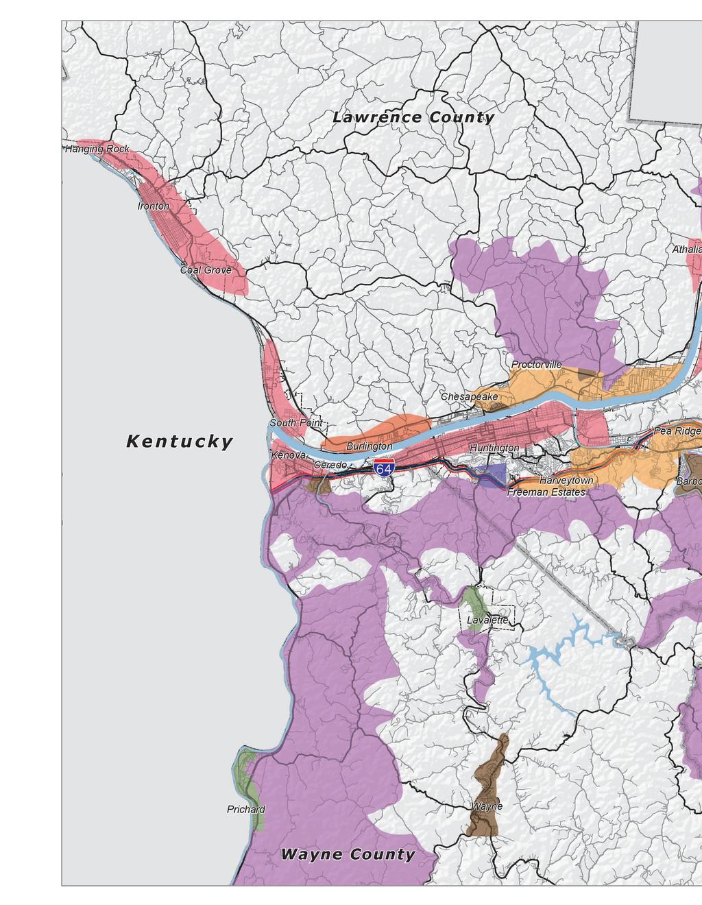
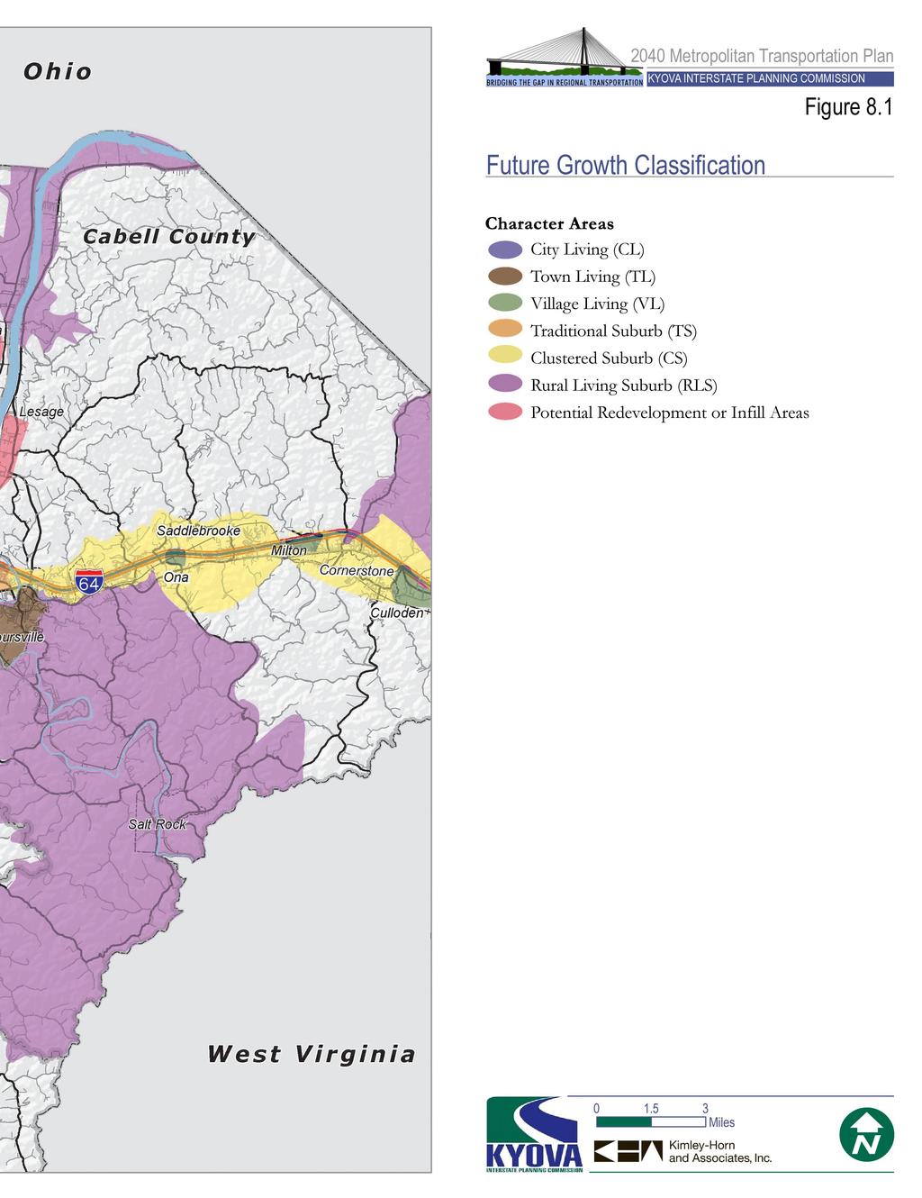
11 Land Suitability with Potential Growth Areas The Land Suitability map shown above considers the suitability of land to receive future growth. Not to be confused with a regulatory plan, this map is simply an expression of where growth likely will occur based on the suitability of land to receive growth. Suitability is an expression of a combination of market forces, environmental conditions, accessibility to public infrastructure, and proximity to existing development. Figure 8.1 (Future Growth Classification) on the following page represents the consideration of suitability and then applies the designation of appropriate and predicted character areas described earlier in this chapter. The result is a representation of a likely growth future for the region based upon data available at the time of this plan. More information regarding the allocation of future growth can be found in the travel demand model documentation available under separate cover. 8-11
12 This page intentionally left blank. 8-12
13
14 This page intentionally left blank. 8-14
Chapter #3 LAND USE AND SCENARIO PLANNING
 Chapter #3 LAND USE AND TABLE OF CONTENTS 3.0 Land Use and Scenario Planning...3-1 3.1 Introduction IMAGINE 2040...3-1 3.2 Background...3-3 3.2.1 4D Analysis...3-3 3.3 Imagine 2040 Scenario Planning...3-7
4.1.3 LAND USE CATEGORIES
 4.1.3 LAND USE CATEGORIES a. City Center District The City Center District incorporates the existing character and mix of uses in downtown Belmont to encourage redevelopment and new development in keeping
Chapter 4. Linking Land Use with Transportation. Chapter 4
 Chapter 4 Linking Land Use with Transportation Chapter 4 59 Chapter 4 Linking Land Use with Transportation Community Design and Transportation Program Introduction Since the 1950s, the predominant development
CITY OF MARYLAND HEIGHTS. Mixed-Use
 CITY OF MARYLAND HEIGHTS Mixed-Use BIG IDEA: Mixed-use is a development approach that should be given strong consideration as part of the Comprehensive Plan update, and subsequent amendments to the Zoning
Living in Albemarle County s Urban Places
 Living in Albemarle County s Urban Places ALBEMARLE COUNTY, VIRGINIA A Closer Look at Albemarle s Approach to Managing Growth and Creating Quality Urban Environments www.albemarle.org Page 2 Living in
EXISTING COMPREHENSIVE PLAN
 EXISTING COMPREHENSIVE PLAN Town Center Land Use Element: V. LAND USE POLICIES Town Center Mercer Island's business district vision as described in "Your Mercer Island Citizen-Designed Downtown" was an
Corridor Vision. 1Pursue Minnehaha-Hiawatha Community Works Project. Mission of Hennepin County Community Works Program
 1Pursue Minnehaha-Hiawatha Community Works Project Minnehaha-Hiawatha Community Works is a project within the Hennepin Community Works (HCW) program. The mission of the HCW program is to enhance how the
DRAFT Subject to Modifications
 TREASURE COAST REGIONAL PLANNING COUNCIL M E M O R A N D U M To: Council Members AGENDA ITEM 8 From: Date: Subject: Staff May 19, 2017 Council Meeting Florida Department of Transportation Complete Streets
Subregion 4 Central Avenue-Metro Blue Line Corridor Transit-Oriented Development (TOD) Implementation Project. Community Meeting April 27, 2011
 Implementation Project. Community Meeting April 27, 2011") Subregion 4 Central Avenue-Metro Blue Line Corridor Transit-Oriented Development (TOD) Implementation Project Community Meeting April 27, 2011 Overview Introduction to Subregion 4 TOD Implementation Program
Subregion 4 Central Avenue-Metro Blue Line Corridor Transit-Oriented Development (TOD) Implementation Project Community Meeting April 27, 2011 Overview Introduction to Subregion 4 TOD Implementation Program
COMMUNITY DESIGN. GOAL: Create livable and attractive communities. Intent
 COMMUNITY DESIGN Intent An attractive, well-designed County will attract quality development, instill civic pride, improve the visual character of the community, and create a strong, positive image for
Plano Tomorrow Vision and Policies
 Plano Tomorrow Vision and Policies PLANO TOMORROW PILLARS The Built Environment The Social Environment The Natural Environment The Economic Environment Land Use and Urban Design Transportation Housing
Sacramento Area Council of Governments (SACOG)
") Sacramento Area Council of Governments (SACOG) The Blueprint Vision The SACOG Board of Directors adopted the Preferred Blueprint Scenario in December 2004, a bold vision for growth that promotes compact,
Sacramento Area Council of Governments (SACOG) The Blueprint Vision The SACOG Board of Directors adopted the Preferred Blueprint Scenario in December 2004, a bold vision for growth that promotes compact,
Policies and Code Intent Sections Related to Town Center
 Policies and Code Intent Sections Related to Town Center The Town Center Vision is scattered throughout the Comprehensive Plan, development code and the 1994 Town Center Plan. What follows are sections
Cumberland Region Tomorrow is a private, non-profit, citizen based regional organization working with Greater Nashville Regional Council
 Cumberland Region Tomorrow is a private, non-profit, citizen based regional organization working with Greater Nashville Regional Council and others in the public and private sectors, dedicated to planning
CHAPTER 7: Transportation, Mobility and Circulation
 AGLE AREA COMMUNITY Plan CHAPTER 7 CHAPTER 7: Transportation, Mobility and Circulation Transportation, Mobility and Circulation The purpose of the Transportation, Mobility and Circulation Chapter is to
CHAPTER 1. Ms. Guajardo s Class - Central Elementary CH 1 1
 INTRODUCTION CHAPTER 1 Ms. Guajardo s Class - Central Elementary CH 1 1 1.1 SETTING South Centre City is a linear corridor south of Downtown Escondido paralleling Centre City Parkway and South Escondido
SECTION ONE: INTRODUCTION. introduction
 introduction 1 INTRODUCTION Since it was first established in 1843 as a trading post for the Hudson s Bay Company, Victoria has evolved into a Provincial capital city that is recognized across Canada and
CITY OF CHARLOTTESVILLE, VIRGINIA CITY COUNCIL AGENDA
 CITY OF CHARLOTTESVILLE, VIRGINIA CITY COUNCIL AGENDA Agenda Date: December 16, 2013 Action Required: Adoption of Resolution Presenter: Staff Contacts: Title: James E. Tolbert, AICP, Director of NDS James
hermitage town center
 hermitage town center A Community Vision prepared by Strada for The City of Hermitage and The Mercer County Regional Planning Commission January 2007 table of contents introduction 3 design principles
Implementation Guide Comprehensive Plan City of Allen
 Implementation Guide 2030 Comprehensive Plan City of Allen DRAFT 2015 Implementation Guide Allen 2030 Comprehensive Plan INTRODUCTION The Comprehensive Plan serves as a guide for the growth and development
CHAPTER 3 VISION, GOALS, & PLANNING PRINCIPLES. City of Greensburg Comprehensive Plan. Introduction. Vision Statement. Growth Management Goals.
 CHAPTER 3 VISION, GOALS, & PLANNING PRINCIPLES Introduction The Greensburg Comprehensive Plan is intended as a working community document. A combination of long and short-term goals, this document is intended
FUTURE LAND USE ELEMENT
 FUTURE LAND USE ELEMENT GOAL I: To create and sustain a great place to live, play, and prosper Objective 1: The City of Ocala shall incorporate the principles and strategies of the Ocala 2035 Vision into
The Five Components of the McLoughlin Area Plan
 The Five Components of the McLoughlin Area Plan This documents contains the complete language of the five components of the McLoughlin Area Plan: The Vision Statement The Values The Guiding Principles
Gold Line Bus Rapid Transit Transit Oriented Development (BRTOD) Helmo Station Area Plan
 Helmo Station Area Plan") Appendix F Gold Line Bus Rapid Transit Transit Oriented Development (BRTOD) Helmo Station Area Plan Introduction and Purpose of the Plan The Gold Line Bus Rapid Transit facility is an eleven-mile dedicated
Appendix F Gold Line Bus Rapid Transit Transit Oriented Development (BRTOD) Helmo Station Area Plan Introduction and Purpose of the Plan The Gold Line Bus Rapid Transit facility is an eleven-mile dedicated
Town Center (part of the Comprehensive Plan)
") Town Center (part of the Comprehensive Plan) Mercer Island Town Center Looking North (2014) In 1994, a year-long process culminated in a set of design guidelines and code requirements for the Town Center
Town Center (part of the Comprehensive Plan) Mercer Island Town Center Looking North (2014) In 1994, a year-long process culminated in a set of design guidelines and code requirements for the Town Center
LAND USE OVERVIEW WHAT YOU WILL FIND IN THIS CHAPTER
 LAND USE WHAT YOU WILL FIND IN THIS CHAPTER Information about the City s expected population and employment growth. Description and capacity of existing and future land use designations. Policies that
Definitions. Average Daily Traffic Demand (ADT): The actual number or projected number of cars that pass a point in a 24-hour period.
: The actual number or projected number of cars that pass a point in a 24-hour period.") Definitions Access Management: A combination of physical techniques and transportation policies used to control the flow of traffic between roads and the surrounding lands. Alternative City Form Scenarios:
Definitions Access Management: A combination of physical techniques and transportation policies used to control the flow of traffic between roads and the surrounding lands. Alternative City Form Scenarios:
Executive Summary. NY 7 / NY 2 Corridor
 Executive Summary NY 7 / NY 2 Corridor Transportation and Land Use Study December 2005 Prepared for: Town of Colonie Capital District Transportation Committee Prepared by: Introduction: Land use decisions
V. Vision and Guiding Principles
 V. Vision and Guiding Principles The Master Plan for the Powers Ferry Corridor seeks a foundation in the desires of the community. At times, various elements of the community offered opposing viewpoints,
Chapter 1: Introduction
 Chapter 1: Introduction The Penn Avenue Community Works Corridor Vision and Implementation Framework presents an integrated communitybased vision and a coordinated, long-term implementation framework for
Chapter 3: Land Use and Local Planning
 3.1 Chapter 3: Land Use and Local Planning 2040 3.2 Chapter 3: Land Use and Local Planning CONTENTS Introduction 3.3 Coordinating Thrive MSP 2040 and Transportation Policy Plan 3.6 Coordination of Regional
7Page 72 CLEMMONS COMMUNITY COMPASS 5 DEVELOPMENT AND GROWTH
 5 Development and Growth WHHAATT DDOOEESS IITT I MMEEAANN TTOO BBEE SSUUSSTTAAI IINNAABBLLEE?? Many communities throughout the U.S. are taking on the challenge of becoming more sustainable. But what exactly
IMPLEMENTATION STRATEGIES. In This Chapter. Goals & Strategies 182 Project List 183 Future Land Use 186 CHAPTER 11 IMPLEMENTATION STRATEGIES
 In This Chapter Goals & Strategies 182 Project List 183 Future Land Use 186 11 IMPLEMENTATION STRATEGIES NORTH AUGUSTA, SC 2017 COMPREHENSIVE PLAN 179 Individual commitment to a group effort that is what
Section 4 BUILDING THE MASTER PLAN
 The Master Plan 33 Section 4 BUILDING THE MASTER PLAN Figure 4:1. A collaborative effort characterized the two design workshops sponsored by DISC to create hypothetical Master Plans for the Towers Property
North Fair Oaks Community Plan Summary and Information
 North Fair Oaks Community Plan Summary and Information WHAT IS THE NORTH FAIR OAKS COMMUNITY PLAN? The North Fair Oaks Community Plan is part of the San Mateo County General Plan, and establishes policies
Prepared for the Citizens of Forsyth County by the City-County Planning Board
 Prepared for the Citizens of Forsyth County by the City-County Planning Board Bryce A. Stuart Municipal Building 100 East First Street, Winston-Salem, NC 27101 336.727.8000 www.cityofws.org/planning www.legacy2030.com
Chapter 1.0 Introduction
 Chapter 1.0 Introduction 1.1 Background The North Metro commuter rail line is part of the RTD FasTracks regional transit system expansion program to build more than 100 miles of rail transit throughout
Lehigh Acres Land Development Regulations Community Planning Project
 Lehigh Acres Land Development Regulations Planning Effort Summary In July, 2010 Commissioner Frank Mann invited the Lehigh Acres community to start discussing how to achieve their recently adopted community
Ivywild On The Creek PRELIMINARY CREEK DISTRICT MASTER PLAN
 Ivywild On The Creek PRELIMINARY CREEK DISTRICT MASTER PLAN Introduction: Rejuvenating an extraordinary Creekside neighborhood THE CREEKSIDE DISTRICT The Ivywild On The Creek Neighborhood District Master
Visioning Statement and Guiding Principles
 Visioning Statement and Guiding Principles Planning for the Future The General Plan The General Plan represents Woodland's shared vision of the future and defines a path to lead the community toward its
A BLUEPRINT FOR BROCKTON A CITY-WIDE COMPREHENSIVE PLAN
 A BLUEPRINT FOR BROCKTON A CITY-WIDE COMPREHENSIVE PLAN Public Meeting October 2016 1 Plan Summary and Discussion Public Meeting May 4 2017 City of Brockton Bill Carpenter, Mayor Department of Planning
City of Long Beach. creating vibrant and exciting places
 City of Long Beach creating vibrant and exciting places Land Use Element Urban Design Element Overview of the two draft General Plan elements Discuss areas of change Economic goals of the plans Case study
CHAPTER 7: VISION AND ACTION STATEMENTS. Noble 2025 Vision Statement
 CHAPTER 7: VISION AND ACTION STATEMENTS This chapter presents the vision, policy and action statements that transform the comprehensive planning study, an analysis of Noble s past, future trends and community
Land Use Amendment in Southwood (Ward 11) at and Elbow Drive SW, LOC
 at and Elbow Drive SW, LOC") 2018 November 15 Page 1 of 10 EXECUTIVE SUMMARY This land use amendment application was submitted by Rick Balbi Architect on 2017 August 31 on behalf of Sable Developments Ltd, and with authorization from
2018 November 15 Page 1 of 10 EXECUTIVE SUMMARY This land use amendment application was submitted by Rick Balbi Architect on 2017 August 31 on behalf of Sable Developments Ltd, and with authorization from
PILLAR FOUR INTEGRATE LAND USE & TRANSPORTATION
 PILLAR FOUR INTEGRATE LAND USE & TRANSPORTATION 8 Scarborough Centre on the Move Transportation Master Plan 123 8 Transportation Pillar Four Integrate Land Use & The fourth pillar focuses on the relationship
Mobility Districts and Traffic Studies
 Mobility Districts and Traffic Studies During the last Comprehensive Plan update in 2008, the City of Sarasota identified the need to develop a citywide strategy for enhancing the mobility options of all
Complete Neighbourhood Guidelines Review Tool
 Complete Neighbourhood Guidelines Review Tool Prepared By: City of Regina Planning Department October 2014 Page 1 of 14 Community Development Review Checklist for Secondary Plans and Concept Plans The
The transportation system in a community is an
 7 TRANSPORTATION The transportation system in a community is an important factor contributing to the quality of life of the residents. Without a sound transportation system to bring both goods and patrons
Staff Report and Recommendation
 Community Planning and Development Planning Services 201 W. Colfax Ave., Dept. 205 Denver, CO 80202 p: 720.865.2915 f: 720.865.3052 www.denvergov.org/cpd TO: City Council Neighborhoods and Planning Committee
Corridors. Re-vitalize our Corridors and Gateways
 Corridors Re-vitalize our Corridors and Gateways Artist s rendering from the 287 Strategic Plan, 2015 Corridors are the major throughways of Loveland but they also provide important commercial, community
1.0 VISION STATEMENT. December 6, PRINCIPLES
 Vision Statement Lincoln Regional Airport 1.0 VISION STATEMENT 1.1 City LOCATION of AND OVERVIEW The Easton Lincoln Place Land Use Master Plan identifies the principles, goals, policies, and standards
Integrating Land Use and Transportation
 FEATURE Integrating Land Use and Transportation For years the transportation profession has emphasized mobility in the development of plans, programs, and projects. This emphasis on mobility moving people
TOD 101 CREATING LIVABLE COMMUNITIES WITH TRANSIT
 1 CREATING LIVABLE COMMUNITIES WITH TRANSIT What are transit Centered Communities? Benefits of Partnerships to Support and Implement What You Will Learn Portland s Pearl District Your Trainers Today Catherine
Additional information about land use types is given in Chapter 5. Design guidelines for Centers and Neighborhoods are given in Chapter 7.
 4. Place Types Introduction In Albemarle County s Development Areas, the Neighborhood is the fundamental unit of community planning. The County s Neighborhood Model, an adopted part of the Comprehensive
Proposed Comprehensive Plan Strategies DRAFT for discussion June 28, 2017
 Proposed Comprehensive Plan Strategies DRAFT for discussion June 28, 2017 Land Use Rural Areas Refine the Farm and Forest area (FF) Update FF boundaries to account for existing lots less than five acres
Joint Meeting City Council and the Plan Commission. September 1st, 2015
 Joint Meeting City Council and the Plan Commission September 1st, 2015 1 The City Plan Commission shall recommend a City Plan for the physical development of the City Article IX Section 2 of the City of
WELCOME and introduction
 1 WELCOME and introduction Mobility Hub Locations within Burlington STUDY OVERVIEW STUDY OBJECTIVES The City of Burlington is developing four Area Specific Plans, one for each of Burlington s Mobility
TRANSIT ORIENTED DEVELOPMENT PINELLAS COUNTY MPO LIVABLE COMMUNITIES INITIATIVE PINELLAS COUNTY COMPREHENSIVE PLAN AMENDMENTS
 PINELLAS COUNTY MPO LIVABLE COMMUNITIES INITIATIVE MODEL LAND DEVELOPMENT CODE TRANSIT ORIENTED DEVELOPMENT PINELLAS COUNTY COMPREHENSIVE PLAN AMENDMENTS MPO Livable Communities Initiative Goal: Improve
Urban Design Manual PLANNING AROUND RAPID TRANSIT STATIONS (PARTS) Introduction. Station Study Areas
 Introduction. Station Study Areas") 111111 PLANNING AROUND RAPID TRANSIT STATIONS (PARTS) Introduction The ION rapid transit system will link Waterloo, Kitchener and Cambridge through a central transit corridor (CTC). There are a number
111111 PLANNING AROUND RAPID TRANSIT STATIONS (PARTS) Introduction The ION rapid transit system will link Waterloo, Kitchener and Cambridge through a central transit corridor (CTC). There are a number
QUINCE ORCHARD/FIRSTFIELD CORRIDOR CITY OF GAITHERSBURG MTAP 2017
 QUINCE ORCHARD/FIRSTFIELD CORRIDOR CITY OF GAITHERSBURG MTAP 2017 ULI LEADERSHIP INSTITUTE 2017 The Team Allison Davis, WMATA Daniel Park, Rodgers Consulting Debbie Albert, Arlington County Harry Ross,
DRAFT. 10% Common Open Space
 % OF CHARLOTTE IS CATEGORIZED AS A. LAND USES : Placeholder map displaying location of Place Type GOALS: Accommodate XX% of future growth. Provide a concentration of primarily commercial and civic activity
Status Update (2006 vs. Now) Citizen s Advisory Committee February Plan for Prosperity
 Citizen s Advisory Committee February Plan for Prosperity") Status Update (2006 vs. Now) Citizen s Advisory Committee February 2018 Plan for Prosperity 2000 2017 2000 2017 Gardnerville Population 6,000 5,760 5746 5,500 5,000 5,067 5,550 5,165 5,394 5,412 5,250
Status Update (2006 vs. Now) Citizen s Advisory Committee February 2018 Plan for Prosperity 2000 2017 2000 2017 Gardnerville Population 6,000 5,760 5746 5,500 5,000 5,067 5,550 5,165 5,394 5,412 5,250
CHAPTER 3. Growth Management
 CHAPTER 3 Growth Management Photo courtesy of J. Sinclair Photography/Visit Winston-Salem Chapter 3. Growth Management Plan Goal: Manage growth and development to reduce sprawl, create a more compact and
A Growing Community Rural Settlement Areas
 Town of Huntsville Official Plan Review - POLICY BACKGROUND PAPER A Growing Community Rural Settlement Areas BACKGROUND: In addition to the fully municipally-serviced Urban Settlement Area and the Hidden
Lesson 6. Corridor Planning
 Lesson 6 Corridor Planning 1 Learning Outcomes Identify land use strategies and solutions that can be incorporated into multimodal transportation corridor plans Identify land use stakeholders and describe
IMPLEMENTING SOMERSET COUNTY S INVESTMENT FRAMEWORK
 IMPLEMENTING SOMERSET COUNTY S INVESTMENT FRAMEWORK SMART CONSERVATION THROUGH SMART GROWTH NJ LAND CONSERVATION RALLY March 22, 2014 Laurette Kratina, PP, AICP, Supervising Planner Somerset County Planning
City of Bristol Route 6 Corridor Implementation Program
 City of Bristol Route 6 Corridor Implementation Program FITZGERALD & HALLIDAY, INC. Innovative Planning, Better Communities June 2017 Route 6 Corridor Plan IMPLEMENTATION PROGRAM The following Implementation
City of Heath. Town Center Concept
 In the give-and-take of getting projects designed, financed, and approved, the famous refrain from the film Field of Dreams is heard often: if you build it, they will come. From the perspective of the
Midtown Greenway Land Use and Development Plan Executive Summary
 Midtown Greenway Land Use and Development Plan Executive Summary Introduction The Midtown Greenway Land Use and Development Plan sets policy direction for land use and development in the Midtown Greenway
Section 3: Land Use M C H E N R Y K A N E. Figure 3.1: Potential Future Municipal Boundaries. Future Municipal Boundaries. County Land Use Plans
 Section 3: Land Use Figure 3.1: Potential Future Municipal Boundaries Land use and transportation are intertwined; yet, land use and transpor- tation planning are often undertaken as separate disciplines.
Silverdale Regional Center
 Silverdale Regional Center Vision for Silverdale Regional Center The Silverdale Regional Center Plan (Plan) will guide the evolution of the Silverdale Regional Center from a collection of strip malls and
TRANSPORTATION AND LAND USE
 CHAPTER 10 TRANSPORTATION AND LAND USE Transportation and land use are intimately linked. The expansion of a highway typically spurs housing, employment growth and land development in the communities that
, C-MS I June 3, 2016 $1500 pd chk #216918
 , C-MS-8 LOTS 21 THROUGH 40, INCLUSIVE, BLOCK 299 CLEMENTS ADDITION TO THE CITY OF DENVER SOUTHEAST QUARTER OF SECTION 34, TOWNSHIP 3 SOUTH, RANGE 68 WEST, SIXTH PRINCIPAL MERIDIAN, CITY
WATERFORD Plan of Preservation, Conservation and Development Supplement Part 1 - Policy Element
 WATERFORD 2012 Plan of Preservation, Conservation and Development 2015 Supplement Part 1 - Policy Element Effective June 11, 2015 2015 Plan Update GOAL To respond to the evolving land use needs and continually
TRANSPORTATION ELEMENT GOALS, OBJECTIVES, AND POLICIES
 TRANSPORTATION ELEMENT GOALS, OBJECTIVES, AND POLICIES GOAL 2 The City shall provide a safe, convenient, effective, and energy efficient multimodal transportation system which is coordinated with the Future
Transportation. Strategies for Action
 Transportation A major priority for the Overlake Neighborhood is to develop a multimodal transportation system. To achieve this system, a balance has to be found among travel, circulation and access needs;
Chapter 1 - General Design Guidelines CHAPTER 1 GENERAL DESIGN GUIDELINES
 CHAPTER 1 GENERAL DESIGN GUIDELINES 1.0 INTRODUCTION This Publication has been developed to provide current, uniform procedures and guidelines for the application and design of safe, convenient, efficient
GUIDING PRINCIPLES IN THIS CHAPTER
 GUIDING PRINCIPLES The guiding principles and design concepts in this chapter work together with the Chapel Hill 2020 Comprehensive Plan to support new public places that can be enjoyed by all while also
Designing Walkable Urban Thoroughfares: A Context Sensitive Approach
 Designing Walkable Urban Thoroughfares: A Context Sensitive Approach Communities Want: Flexibility Compatibility with adjacent land uses Balanced land use/transportation functions Safe and attractive streets
The Corporation of the Town of Milton
 Report To: From: Council Barbara Koopmans, Commissioner, Planning and Development Date: May 7, 2018 Report No: Subject: Making it Possible Positioning the Town s Strategy for Growth and Economic Development
Unique. Livable. Connected. Sustainable. Anticipate and Manage Change. Variety of Housing Choices. Enhanced Arterial Corridors
 Neighborhood Vision The Old Town Neighborhoods are Unique, Livable, Connected, and Sustainable. As mature, established neighborhoods, many of the ideas and opportunities expressed by stakeholders in support
4 Sustainability and Growth Management
 4 Sustainability and Growth Management Introduction Traditionally, has assumed growth and development with limited consideration for the long-term negative social, environmental or economic impacts on
CONTENTS 8.0 LAND USE 8.1 GENERAL LAND USE 8.2 RESIDENTIAL 8.3 MIXED USE 8.4 COMMERCIAL 8.5 EMPLOYMENT LANDS
 8-2 Land Use 8.0 LAND USE CONTENTS 8.1 GENERAL LAND USE 8.1.1 Uses provided for in all Land Use Designations 8.1.2 Uses prohibited in Hazardous Lands, Hazardous Sites and Special Policy Areas 8.1.3 Uses
Tri-County Transportation & Land Use Study. Steering Committee Meeting May 14, 2009
 Tri-County Transportation & Land Use Study Steering Committee Meeting May 14, 2009 Agenda Recap of Study Goals and Objectives Update on CV Land Use Model: Business as Usual (BAU) Growth Scenario Pros vs
THE POLICY FRAMEWORK FOR WALKABLE COMMUNITIES. Community Technical Assistance Program Building Active Communities Institute March 2016
 THE POLICY FRAMEWORK FOR WALKABLE COMMUNITIES Community Technical Assistance Program Building Active Communities Institute March 2016 ACTIVE COMMUNITIES BACK THEN ACTIVE COMMUNITIES BACK THEN Lifestyle
URBAN DESIGN BRIEF. 2136&2148 Trafalgar Road. Town of Oakville
 URBAN DESIGN BRIEF 2136&2148 Trafalgar Road Town of Oakville Prepared By: METROPOLITAN CONSULTING INC For 2500674 Ontario Inc November 2016 TABLE OF CONTENTS Page No. 1.0 Introduction/Description of Subject
SECTION II SECTION II STATEMENT OF GOALS, OBJECTIVES, PRINCIPLES, ASSUMPTIONS, POLICIES AND STANDARDS
 STATEMENT OF GOALS, OBJECTIVES, PRINCIPLES, ASSUMPTIONS, POLICIES AND STANDARDS 1 2 STATEMENT OF GOALS, OBJECTIVES, PRINCIPLES, ASSUMPTIONS, POLICIES AND STANDARDS INTRODUCTION The New Jersey Municipal
AWH REPORT OF THE PLANNING AND DEVELOPMENT DEPARTMENT FOR APPLICATION FOR REZONING ORDINANCE TO PLANNED UNIT DEVELOPMENT
 AWH REPORT OF THE PLANNING AND DEVELOPMENT DEPARTMENT FOR APPLICATION FOR REZONING ORDINANCE TO PLANNED UNIT DEVELOPMENT MAY 8, 2014 The Planning and Development Department hereby forwards to the Planning
RESIDENTIAL DISTRICTS
 RESIDENTIAL DISTRICTS The residential district standards have been revised to reflect on-the-ground conditions, while continuing to respect the use patterns established within the neighborhoods. This will
Anatomy of A Vibrant Downtown. Anatomy of a Vibrant Downtown
 Anatomy of A Vibrant Downtown The goal of MAIN ST. REVITALIZATION PLANNING is to provide a framework that will help transform your downtown into a VIBRANT DOWNTOWN a place where people love to LIVE, WORK,
BROOKLYN PARK / 85TH AVE LRT STATION CDI DEVELOPMENT GUIDELINES DRAFT
 August 2018 Page intentionally left blank The Brooklyn Park Library adjacent to the 85th Ave LRT Station Area. OVERVIEW The Blue Line LRT Extension / Bottineau corridor offers a unique opportunity to leverage
Section 9 NEIGHBORHOOD DESIGN
 Section 9 NEIGHBORHOOD DESIGN City of Lancaster Comprehensive Plan D u n k i n, S e f k o & A s s o c i a t e s, I n c. NEIGHBORHOOD DESIGN INTRODUCTION There are many ways in which a neighborhood can
Calvert County Comprehensive Plan
 Calvert County Comprehensive Plan Summary of Key Outcomes from the Issue Identification Workshops and Surveys February May, 2017 Providing an Efficient and Multi-modal Transportation System Overall, the
Strategic Growth Area #1 Northampton Boulevard Corridor Area
 Strategic Growth Area #1 Northampton Boulevard Corridor Area Description Strategic Growth Area #1 has established itself as a major employment center in Southside Hampton Roads. Opportunities exist to
ARLINGTON COUNTY, VIRGINIA
 ARLINGTON COUNTY, VIRGINIA County Board Agenda Item Meeting October 15, 2005 DATE: September 28, 2005 SUBJECT: Request to Advertise the adoption of the 2005 Clarendon Sector Plan C. M. RECOMMENDATION:
Nader Obied Abd al raheem hathat. Dr. Farid S. Al-Qeeq
 Submit from Nader Obied Abd al raheem hathat Submit to Dr. Farid S. Al-Qeeq DEC. 2010 NEW URBANISM : is the most important planning movement this century, which emerged during the late 1980s and early
Chapter 2: Vision, Goals and Strategies
 Chapter 2: Vision, Goals and Lake Elmo Today & Tomorrow Comprehensive Plan 2040 2 VISION, GOALS & STRATEGIES - DRAFT 4-6-2018 INTRODUCTION Comprehensive Plan Purpose Perhapse the most important objective
VILLAGE OF CLEMMONS PLANNING BOARD DRAFT STAFF REPORT
 VILLAGE OF CLEMMONS PLANNING BOARD DRAFT STAFF REPORT PETITION INFORMATION Docket # C-226 Staff Megan Ledbetter Petitioner(s) JBJH Properties, LLC Owner(s) JBJH Properties, LLC Subject Property 5892-49-1766
Ten Mile Creek Planning Area
 PLANNING AREA POLICIES TEN MILE CREEK Ten Mile Creek Planning Area Location and Context The Ten Mile Creek Planning Area ( Ten Mile Creek area ) is located south of the current Boise AOCI, generally south
Franklin/Myrtle School Small Area Plan Adopted February 18, 2003
 Franklin/Myrtle School Small Area Plan Adopted February 18, 2003 Introduction This plan area includes properties on all four corners of the Franklin/Myrtle School intersection. The magnitude of development