The Gore Road Queen Street East to Castlemore Road
|
|
|
- Damian Griffith
- 5 years ago
- Views:
Transcription


1 Municipal Class Environmental Assessment The Gore Road Queen Street East to Castlemore Road Public Open House # 1 Date: Thursday May 29, 2014 Time: 5:30pm to 8:30pm Location: Gore Meadows Community Centre

2 1 Welcome to Public Open House # 1 We invite you to learn about the Municipal Class Environmental Assessment for The Gore Road (from Castlemore Road to Queen Street East) Questions? Ask any member of the team here tonight. If we don t have an answer, we ll get it for you This evening we will introduce you to the project, specifically: What this study is about Why this planning study is being done What has happened so far What the planning process is moving forward How you can help plan the improvements to The Gore Road We are looking for your feedback. Please take a sheet from the registration table and record your comments on: The work we have done to date. What areas of study are important to you? The environment? The cultural features? The flow of transportation? The proposed criteria for evaluating the improvements Please submit your comment sheet here or send your feedback to Neal Smith, Project Manager, Region of Peel neal.smith@peelregion.ca


3 2 Why This Study? Why Now? We are one of the fastest growing Regions in Canada. As our population grows, so does our demand for safe and efficient roadways that accommodate cars, transit, pedestrians and cyclists The recent widening of The Gore Road stems from planning work that was completed over a decade ago to accommodate the growth that we see today and expect by 2020 Since good planning takes time, we re starting now to investigate options and complete the necessary studies for The Gore Road to be ready for future growth beyond 2020 McVean Drive Corridor under Study The Gore Road Clarkwway Drive

4 3 Making The Gore Road Better Complete Streets. The intent is for The Gore Road to be as functional and comfortable as possible for all who use it. This includes children, seniors, cyclists, motorists, transit users and pedestrians, including those with disabilities. Ensuring that there is a place for trees and the natural environment are other key characteristics of a complete street Recent improvements to The Gore Road have included the addition of 2 lanes, sidewalks, intersection redesign and turning lanes Other work included bridge widening, utility relocation, drainage improvements and safety measures such as school crossings Design concepts for this study will consider: - Better transit facilities (e.g., bus bays, shelters) - Continuous sidewalks and safer pedestrian crossings - Space for cyclists - Traffic signal coordination - New or modified bridges - Additional through lanes or turning lanes - Multi-use path to The Gore Road Meadows Community Centre Source: Complete Streets by Design, Toronto Centre for Active Transportation


5 4 Design Ideas to Consider Many cities have found ways to improve the safety and attractiveness of walking and cycling. Here are some ideas that may be considered for The Gore Road: Eglinton Avenue West Etobicoke, Toronto Bike path and sidewalk set back to create car waiting area at stop sign for minor cross street and reduce blockage of sidewalks and paths Separate bicycle and pedestrian crossings where multiuse pathways cross an intersection Bicycle detection through in-pavement detectors and/or push buttons Rochussenstraat Rotterdam, The Netherlands Separate areas for pedestrians, cyclists, and bus loading at bus stops Dedicated traffic signals for left turns, right turns, bicycles, and pedestrians to reduce conflicts between turning vehicles and crossing cyclists / pedestrians Eendrachtsplein Rotterdam, The Netherlands Protected waiting area behind the curb for waiting through and turning cyclists Setback crosswalk reduces pedestrian crossing distance High-visibility crosswalk and bicycle markings at conflict areas Two-stage turn queue boxes for bicycle left turns Sherbourne Street Toronto Finch Hydro Corridor Trail North York, Toronto Bedumerweg Groningen, The Netherlands Source of all photos: AECOM
6 5 Study Schedule and Planning Process November The Gore Road EA Completed Design and Construction (2 Phases) Peel Long Range Transportation Plan (LRTP) Update We Are Here Winter/Spring 2014 Phase 3a Summer/Fall 2014 to Winter 2015 Phase 3b Spring/Summer 2015 Phase 4 Recommendations included: The Gore Road widening from Queen Street East to Castlemore Road (2 to 4 lanes in certain sections) Realigning the centreline south of Fitzpatrick Drive to mitigate impacts to cemeteries and watercourses This phase involved: Detailed design and approvals Acquiring 45m of right-of-way Construction in phases This phase involved: Identifying The Gore Road improvements (e.g., future widening, transit enhancements and active transportation) High level evaluation of alternative solutions Addressed Phases 1 and 2 of the Class Environmental Assessment Process This phase involves: Confirm Phases 1 and 2 of the LRTP Problem and opportunity statement Document existing and future conditions (e.g., traffic, natural, socioeconomic and cultural environments) Field investigations (e.g., natural environment) Preliminary design concepts This phase involves: Review and consider input received during and following Public Open House # 1 Evaluation of alternative design concepts Preliminary recommended design concept Project description Mitigation measures Next steps This phase involves: Review and consider input received during and following Public Open House # 2 File Environmental Study Report Public opportunity to request additional studies and review by the Minister of the Environment


7 6 Future Land Use City of Brampton, Secondary Plan Area 47 1 Corridor under Study Project Study Area


8 7 Problem/Opportunity Statement The problem/opportunity statement forms the basis for the entire study. For The Gore Road, the statement is: Approved and planned growth within and outside the study area will require improvement to avoid traffic congestion and deterioration of road conditions over the next 10 to 25 years These factors affect the level of service and adequacy of the road resulting in the need for improvements Alternative design concepts to address these problems will consider opportunities to increase road capacity, enhance streetscape conditions and encourage the use of non-auto modes of transportation by providing supporting infrastructure based on Complete Streets (e.g., transit stops, better accommodations of cyclists and pedestrians including people with disabilities)
9 8 Transportation Existing and Future Conditions

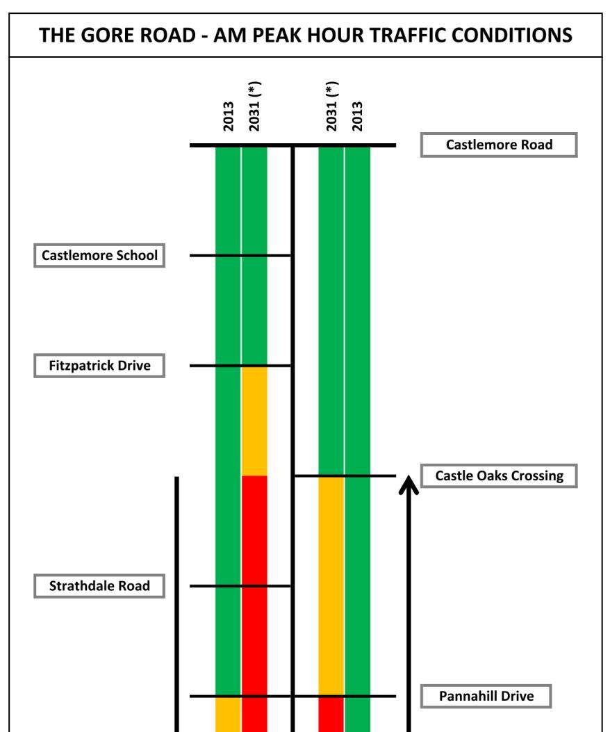
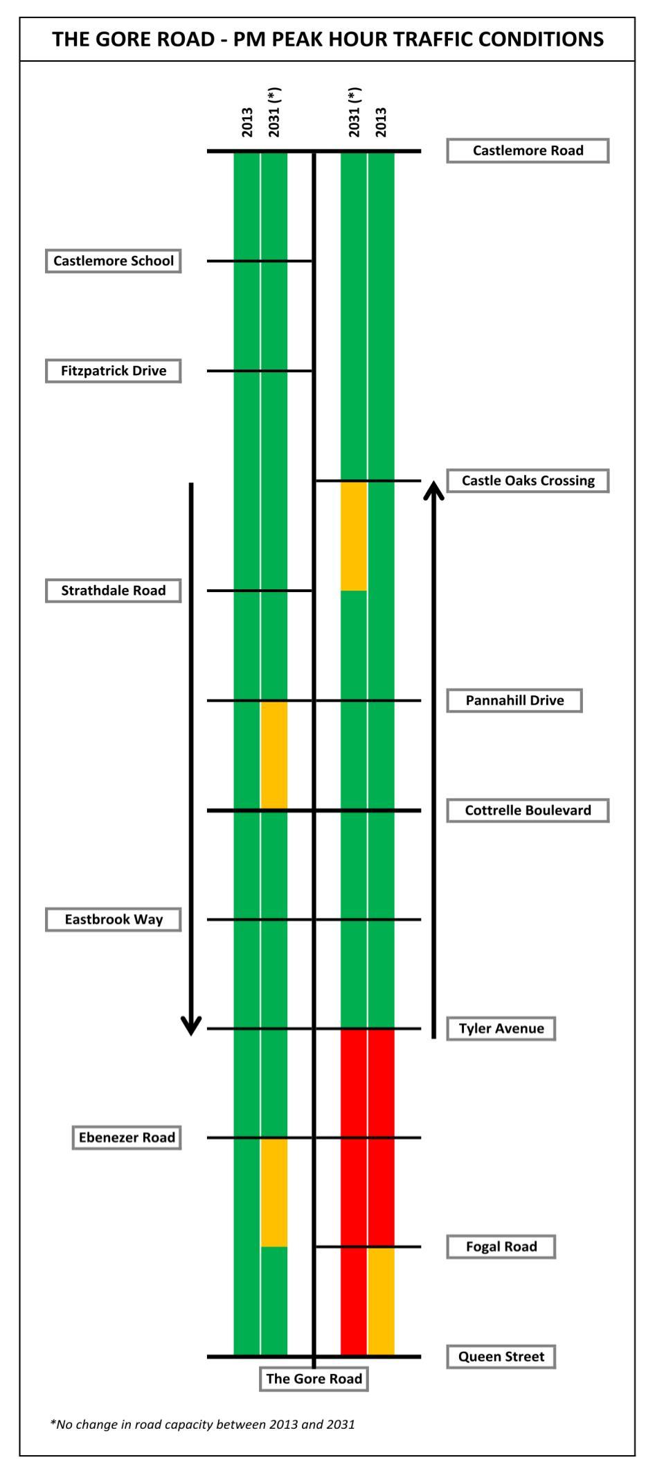
10 9 Transportation Operations and Safety Traffic Volumes/Growth The Gore Road has experienced dramatic growth in usage since the 1990s but demand has leveled off since Planned development to the north of Castlemore Road and beyond is expected to trigger a surge in future demand. The Gore Road will be congested when that development is complete (after 2020) Intersection Operations/Congestion With the recent widening, all intersections on The Gore Road currently operate well, with the exception of Queen Street, where several movements are delayed during peak periods. Delays are also known to occur during concentrations of school, religious, or banquet traffic Vehicular Safety We are continuing to investigate the safety record of The Gore Road, but nothing unusual or problematic has emerged yet Transit In peak periods, there is a bus on The Gore Road every 12 minutes south of Cottrelle, and every 20 minutes to the north. Brampton Transit plans to increase service in accordance with demand. Brampton has designated The Gore Road as a Primary Transit Corridor Pedestrian Movement and Personal Safety A multi-use trail is planned for the west side of The Gore Road Improvements can be made in maintenance practices that will help the pedestrian environment Cycling Activity and Safety Only Castle Oaks Crossing has bike lanes today Bicycle Lane on Castle Oaks Crossing Need to maintain clear paths for pedestrians 12,000 10,000 8,000 6,000 4,000 2,000 0 Average Daily Traffic on The Gore Road Brampton Transit in The Gore Road Area NB SB

11 10 Existing Environmental Conditions: West Humber Tributary Fluvial geomorphology is used to understand the historical and possible future movement of the stream channel allows for the proper planning of road structures such as bridges and culverts So far, we have reviewed historical aerial photography as well as surficial geology, land use and topography Future activities include a field assessment along the stream to collect additional important data


12 11 Existing Environmental Conditions: Aquatic (water) Field investigations on various aquatic features of the adjacent stream will identify how road improvements could affect fish communities and habitat Preliminary research has confirmed that this is currently classified as a degraded warm water stream with no sensitive species Future investigations will study fish habitat features such as: - Bank stability - Barriers to fish movement McVean Drive Watercourse crossings to be investigated Clarkwway Drive - Aquatic vegetation The Gore Road West Humber River Tributary at North Wylies Bridge-West Side of Road West Humber River Tributary at South Wylies Bridge-East Side of Road


13 12 Existing Environmental Conditions: Terrestrial (on ground) The following 6 vegetation types are found within the study area: Types 1,2,3 and 5 1. Mineral Cultural Meadow Ecosite 2. Dry-Moist Old Field Meadow Type 3. Fresh-Moist Ash Lowland Deciduous Forest Type 4. Fresh-Moist Willow Lowland Deciduous Forest Type 5. Cattail Mineral Shallow Marsh Type McVean Drive Types 2 and 5 Types 2 and 4 Types 1, 5 and 6 Clarkwway Drive 6. Reed-canary Grass Mineral Meadow Marsh Type None of the above communities are considered to be rare within the Region of Peel or Provincially Significant A tree inventory survey will be completed along the entire corridor Project study area will also be screened for potential Species at Risk (e.g., Butternut Tree, Barn Swallows) Type 2 The Gore Road Type 1 Type 2 Cattail Mineral Shallow Marsh Type Fresh Moist Ash Lowland Deciduous Forest Type


14 13 Existing Environmental Conditions: Drainage and Stormwater Management Stormwater Management Pond Outlet to West Humber Tributary Castlemore Bridge Wylie North Bridge Stormwater Management Pond South of Castle Oaks Crossing Wylie South Bridge Recessed Catchbasin at Castlemore Bridge Culvert and Drainage Ditch South of Castlemore Road Catchbasin South of Castle Oaks Crossing


 recently went through a full")
15 14 Existing Environmental Conditions: Archaeology and Built Heritage Archaeology The existing road does not have any archaeological interest, however, there are 12 areas in the surrounding area that may be of archaeological interest Built Heritage The following cultural heritage resources are located near The Gore Road Ebenezer Schoolhouse 4494 Ebenezer Road *Designated* Ebenezer Primitive Methodist Chapel and Cemetery 8999 The Gore Road *Designated* Mature Spruce Tree Line St. John Cemetery Ebenezer Schoolhouse (today Ebenezer Community Hall) recently went through a full restoration


16 15 Existing Land Uses North Area Primarily open space and institutional recreational Predominately low to medium residential with several schools, religious/spiritual institutions that serve the surrounding community


17 16 Existing Land Uses South Area Retail commercial uses, provide a variety of goods and services including food, medical, clothing, financial and personal care that cater the ethnically diverse community
18 17 Preliminary Evaluation Criteria Before we can decide on the best alternatives for The Gore Road, we need to identify the criteria that will be used to evaluate the alternatives Please use the comment sheet to tell us which criteria are important to you Technical Transportation Effect on transit, cycling and pedestrian facilities Effect on local street connectivity Effect on safety Effect on overall network delay and future road capacity beyond 2020 Constructability Effect on ease of construction including phasing Stormwater Management Effect on stormwater management including drainage patterns Utility Conflicts Effect on existing utilities located within and outside of the Region s right of way Natural Environment Terrestrial Features Effects on terrestrial habitats or functions (e.g., trees, shrubs, vegetation) Effect on terrestrial species including Species at Risk Aquatic Features Effects on aquatic habitat or functions Effect on aquatic species including Species at Risk Groundwater and Surface Water Effect on groundwater Effect on surface water Socio-Economic Environment Property Requirements Effect on public property Effect on private property Overall Community Effect on existing established communities and businesses, noise/dust/vibration Effect on planned future land use along corridor Street Character and Vibrancy Effect on visual character of road corridor Effect on urban design Cultural Environment Archaeological Resources Effect on known or potential significant archaeological resources Built Heritage and Cultural Landscape Effect on built heritage resources and cultural landscape features Costs Effect on value/cost-benefit and affordability
19 18 Alternatives Under Consideration Many alternatives are being considered to address problems and opportunities: Long List of Alternative Ideas Screening Result Alternative Groups for Further Study 1. Increase Intersection Capacity a. More green time for North-South traffic b. Longer traffic signal cycle length c. Double left turn lanes d. High-capacity intersection designs to reduce turning traffic conflicts Carry Forward (Group 1) (for testing and refinement) Carry Forward (Group 1) Carry Forward (Group 2) Carry Forward (Group 2) (at grade options) e. Pedestrian bridges or tunnels across The Gore Road Set Aside, not appropriate in this context Alternative Group 1: Operational Improvements (No Infrastructure) 1a) More green time for N-S traffic 1b) Increase cycle length 1c) Coordinate signal timing 1d) Signage review/ improvement f. Wide median for two-stage pedestrian crossings Set Aside, excessive penalties to pedestrians 2. Increase Roadway Capacity a. Adding one through lane in each direction throughout the corridor b. Use reversible lanes to increase peak direction capacity without widening in both directions 3. Manage Gore Road Operations a. Reduce the number of intersections and driveways Carry Forward (Group 3) Carry Forward (Group 3) (five-lane option with tidal flow operation) Carry Forward (Group 3) Alternative Group 2: Localized Site Specific Infrastructure Changes 2a) Double left turn lanes 2b) High-Capacity intersection designs 2c) Reduce driveway left turns 2d) Implement bus bays b. Implement bus bays c. Restrict left turns (in peak periods, or all day) Carry Forward (Group 2) Carry Forward (Group 2) d. Restrict truck traffic No Further Action, trucks already restricted from using The Gore Road e. Coordinate signal timing f. Increase the speed limit Set Aside, not desirable g. Ensure road signs are clear and properly located h. Restrict advertising and other motorist distractions No Further Action, By-Laws in place i. Providing trip planning and real-time traffic information to influence motorists decisions to use The Gore Road (time, mode, route of travel) Carry Forward (Group 1) Carry Forward (Group 1) No Further Action, GTA-wide activity, not specific to The Gore Road Alternative Group 3: Whole of Corridor Infrastructure Changes 3a) Adding one lane in each direction in part or all of the corridor 3b) Five-lane configuration with Tidal Flow operation (reversible median lane) 3c) Eliminate midblock left turns
20 19 Analysis and Evaluation Process Review and comment on: - Draft Evaluation Criteria - Alternative Design Focus Areas: - Increasing intersection capacity - Increasing midblock capacity - Managing corridor operations Grouping of Short Listed Design Alternatives Consider Feedback from Public and Agencies/ Stakeholders Confirm Evaluation Methodology Weighting/scoring vs Paired Comparison vs Multi- Factor Evaluation Approaches Qualitative + Quantitative Develop Evaluation Criteria Public Open House #1 May 29, 2014 *We Are Here* Respond to Agency and Public Comments Alternative Design Concepts including Supporting Plans Showing Limits of Construction Evaluation of Alternative Design Concepts and Select the Recommended Concept Project Team/ Region Meeting Agency/Stakeholder Meetings Refine/Finalize Alternative Design Concept Evaluation for Presentation to the Public Public Open House #2 Early 2015 Consider Feedback from Public and Agencies/ Stakeholders Alternative Group 1: Operational Improvements (No Infrastructure) Alternative Group 2: Localized or Site Specific Infrastructure Changes Alternative Group 3: Whole Corridor Infrastructure Changes Overview of POH #1 Review of engineering assessments Identification and Evaluation of Alternative Design Concepts Recommended Alternative Design Concept including Project Description and Property Requirements Mitigation Measures Next Steps Respond to Agency and Public Comments
21 20 What s Next for the Study? Study s Next Steps Confirm existing conditions through site specific investigations Spring/Summer 2014 Describe and evaluate alternative design concepts Fall/Winter 2014 Identify preliminary recommended design concept Early 2015 Consult with key stakeholders and review agencies prior to Open House # 2 Notification and hosting of Open House # 2 Early 2015 Please note, timing and cost of improvements are determined at the end of the study following confirmation of the recommended design alternative(s).
22 21 How You Can Participate Planning Your Way The best plan for The Gore Road will be created with input of the community Thank you for your participation and feedback today Please submit your comment sheet here or send your feedback by , fax or letter to Neal Smith or Stephen Schijns (see below) To stay connected, please visit the study website at If you have signed in, you will be added to the study mailing list Neal Smith, C.E.T Project Manager Region of Peel 10 Peel Centre Drive, Suite B, 4 th Floor Brampton, Ontario L6T 4B9 Tel: ext Toll Free: , Fax: neal.smith@peelregion.ca Stephen Schijns, P.Eng Project Manager AECOM 5080 Commerce Boulevard Mississauga, Ontario L4W 4P2 Tel: Direct: stephen.schijns@aecom.com
23 The Gore Road s Role in the Community We want to know what The Gore Road means to you and how it can best suit your needs in the future Using the sticky dots, highlight areas on the large map that are of concern and use post-it notes provided here to tell us what you feel should be important considerations when it comes to planning for your road and the community. Use this list to get you thinking: Safety Economic Vitality Utilities Traffic Congestion Place post-it notes on blank space below Noise Right of Way Constraints Water Crossings Cultural Heritage Resources School Crossings Aging Society Cycling Crossing Areas between Traffic Lights Vibration Walking Path Connectivity Stormwater Management Bridges Access to Businesses Nature Unsignalized Interesctions
Mavis Road Class Environmental Assessment
 Mavis Road Class Environmental Assessment Public Information Centre #2 Wednesday November 9, 2016 6:00 to 8:00 p.m. Please sign in and complete a comment sheet Review the displays on your own or join in
St. Clair Avenue West Area Transportation Master Plan
 1 (Between Keele Street and Old Weston Road) Public Information Centre 1 December 2, 2015 2 Welcome Welcome to the first Public Information Centre for the St. Clair Avenue West Area. The panels will present
Highway 427 Industrial Secondary Plan Area 47 Schedule C Class Environmental Assessment For Arterial Roadways
 Welcome to Pubic Information Centre #1 Highway 427 Industrial Secondary Plan Area 47 Schedule C Class Environmental Assessment For Arterial Roadways Welcome to Open House # 1 Tonight, we invite you to.
Commissioners Road West Realignment Environmental Assessment
 City of London Commissioners Road West Realignment Environmental Assessment Public Information Centre No. 1 March 30, 2017 Welcome to the Public Information Centre This first Public Information Centre
Bostwick Road. Municipal Class Environmental Assessment. Public Information Centre #2 June 14, City of London
 Bostwick Road Municipal Class Environmental Assessment Public Information Centre #2 June 14, 2017 Welcome! Welcome to the 2 nd Public Information Centre for the. Representatives from the and the consulting
Commissioners Road West Realignment Environmental Assessment
 City of London Commissioners Road West Realignment Environmental Assessment Public Information Centre No. 2 November 29, 2017 Welcome to the Public Information Centre This 2 nd Public Information Centre
Portage Parkway Environmental Assessment Public Information Centre No. 1
 City of Vaughan Portage Parkway Environmental Assessment Public Information Centre No. 1 November 25, 2015 Welcome to the Public Information Centre This first Public Information Centre (PIC) introduces
Bostwick Road. Municipal Class Environmental Assessment. October 13, City of London. Bostwick Road Municipal Class Environmental Assessment
 Bostwick Road Municipal Class Environmental Assessment October 13, 2016 Welcome! Welcome to the first Public Information Centre for the Bostwick Road Municipal Class Environmental Assessment. Representatives
Municipal Class EA Study Public Information Centre No. 1 December 13, :00 pm 7:00 pm. Please sign in so we can keep you updated on this study
 Reconstruction of Regional Road 45 (Creek Road) Between Regional Road 27 (River Road) and Regional Road 63 (Canborough Road) in the Township of Wainfleet Municipal Class EA Study Public Information Centre
Improvements Municipal Class Environmental Assessment. Public Information Centre #1 June 11, 2015
 Western Road & Sarnia Road/Philip Aziz Avenue Improvements Municipal Class Environmental Assessment Public Information Centre #1 June 11, 2015 1. Welcome We re hosting this Public Information Centre (PIC)
Heritage Road Improvements from Steeles Avenue to Rivermont Road
 The Corporation of the City of Brampton Heritage Road Improvements from Steeles Avenue to Rivermont Road Class Environmental Assessment Study (Schedule C) September 19, 2013 The Corporation of the City
WELCOME TO OPEN HOUSE TWO November 28, 2018
 Langstaff Road Weston Road to Highway 7 Class Environmental Assessment Study WELCOME TO OPEN HOUSE TWO November 28, 2018 Please sign in and join our mailing list Study Overview York Region is conducting
Baby Point Wastewater Pumping Station Forcemain Class Environmental Assessment Study
 Baby Point Wastewater Pumping Station Forcemain Class Environmental Assessment Study Public Drop-in Event 1 Thursday, October 12, 2017 6:00 p.m. to 8:00 p.m. Humbercrest United Church Welcome Welcome to
Recreational Pathway Crossing of Richmond Street Municipal Class Environmental Assessment. Public Information Centre #2 April 22, 2015
 Recreational Pathway Crossing of Richmond Street Municipal Class Environmental Assessment Public Information Centre #2 April 22, 2015 1. Study Process PHASE 1 PHASE 2 PHASE 3 PHASE 1 : Problem/Opportunity
City of Toronto. Emery Village Transportation Master Plan
 City of Toronto Emery Village Transportation Master Plan May 2009 Emery Village Transportation Master Plan Toronto, ON May 2009 Consulting Inc. 100 York Blvd., Suite 300 Richmond Hill, ON L4B 1J8 Tel:
WELCOME TO OPEN HOUSE # 3
 Bayview Avenue Class Environmental Assessment Study Steeles Avenue to Elgin Mills Road WELCOME TO OPEN HOUSE # 3 Please sign in and join our mailing list Why Are We Here Tonight? Study Process and Purpose
City of Cornwall Municipal Class Environmental Assessment. Proposed Improvement and Extension of Lemay Street
 Welcome City of Cornwall Municipal Class Environmental Assessment Proposed Improvement and Extension of Lemay Street Redevelopment and Design of the Municipal Works Yard Public Information Centre #1 Thursday,
FANSHAWE PARK ROAD/RICHMOND STREET INTERSECTION IMPROVEMENTS. PUBLIC INFORMATION CENTRE 2 June 16, 2016
 FANSHAWE PARK ROAD/RICHMOND STREET INTERSECTION IMPROVEMENTS Municipal Class Environmental Assessment PUBLIC INFORMATION CENTRE 2 June 16, 2016 ACCESSIBILITY Under the Accessibility Standards 2015 for
Lower Don River West Remedial Flood Protection Project TABLE OF CONTENTS. Page. Executive Summary
 TABLE OF CONTENTS Page Executive Summary 1.0 INTRODUCTION...1-1 1.1 Purpose of the Undertaking...1-1 1.2 Study Area Description...1-1 1.3 Description of the Undertaking...1-1 1.4 Rationale for the Undertaking...1-2
Welcome. Community Consultation Meeting November 28, Review and discuss the Bathurst Quay Neighbourhood Plan Framework
 Welcome Community Consultation Meeting November 28, 2016 Why Are We Here Today? Review and discuss the Bathurst Quay Neighbourhood Plan Framework Review and discuss an Action Plan for Implementation Next
Western Road/Wharncliffe Road North Widening from Platts Lane to Oxford Street. Municipal Class Environmental Assessment Public Information Centre #1
 Western Road/Wharncliffe Road North Widening from Platts Lane to Oxford Street Municipal Class Environmental Assessment Public Information Centre #1 June 11, 2014 Welcome Welcome to the first Public Information
The purpose of tonight s PIC is to:
 The purpose of tonight s PIC is to: Provide an overview of the work completed to date and a summary of the Class EA process being followed; Provide a summary of public input received so far, including
Second Line West Pedestrian/Cyclist Crossing of Highway 401 Class EA. Second Line West Pedestrian/Cyclist Crossing of Highway 401 Class EA
 1 1 Purpose of Public Information Centre #2 To provide interested and/or potentially affected stakeholders with an opportunity to participate in the planning and decision-making process for this Municipal
Better Cycling. The City will update the cycling master plan (London ON Bikes) based on the approved BRT network.
 based on the approved BRT network.") Better Cycling Dedicated bike facilities will be constructed along BRT corridors where space is available. Nearby bike routes will also be upgraded to ensure a complete network is available for cyclists.
Better Cycling Dedicated bike facilities will be constructed along BRT corridors where space is available. Nearby bike routes will also be upgraded to ensure a complete network is available for cyclists.
Rapid Transit Implementation Working Group
 Rapid Transit Implementation Working Group October 12, 2017 1 Agenda 1. Consultation Update 2. Technical Work Update 3. LTC Rapid Transit Integration 4. Next Steps 2 Consultation Update 3 Consultation
Public Information Centre No. 1 King-Vaughan Road Bridge Replacement Municipal Class Environmental Assessment City of Vaughan
 Public Information Centre No. 1 King-Vaughan Road Bridge Replacement Municipal Class Environmental Assessment City of Vaughan Date: April 7, 2016 Location: Al Palladini Community Centre, Meeting Room #1
Blackfriars Bridge Municipal Class Environmental Assessment. Public Information Centre #1 November 19 th, 2014
 Blackfriars Bridge Municipal Class Environmental Assessment Public Information Centre #1 November 19 th, 2014 Why are you here tonight? To determine the future requirements of the river crossing at Blackfriars
The West Vaughan Employment Area Secondary Plan Policies
 Part 2: The West Vaughan Employment Area Secondary Plan Policies 2.1 General Policies It is the policy of Council: 2.1.1. That the West Vaughan Employment Area (the WVEA), identified on Schedule 1, will
North York Centre South Service Road
 North York Centre South Service Road Municipal Class Environmental Assessment Addendum Potential Changes to Doris Avenue, Bonnington Place & Tradewind Avenue Study Summary (June 11, 2015) toronto.ca/nyc-south-road.
Toronto Complete Streets Guidelines
 Toronto Complete Streets Guidelines 108 110 7.1 Green Infrastructure Design Principles 112 7.2 Context-Sensitive Green Streets 114 7.3 Key Green Street Elements Green infrastructure refers to natural and
The Illinois Department of Transportation and Lake County Division of Transportation. Route 173, including the Millburn Bypass
 The Illinois Department of Transportation and Lake County Division of Transportation welcome you to this Public Hearing for U.S. Route 45 from Illinois Route 132 to Illinois Route 173, including the Millburn
Scope of Services. River Oaks Boulevard (SH 183) Corridor Master Plan
 Corridor Master Plan") Scope of Services River Oaks Boulevard (SH 183) Corridor Master Plan PROJECT AREA The project area consists of the River Oaks Boulevard (SH 183) corridor bounded by SH 199 at the northern end and the Trinity
Scope of Services River Oaks Boulevard (SH 183) Corridor Master Plan PROJECT AREA The project area consists of the River Oaks Boulevard (SH 183) corridor bounded by SH 199 at the northern end and the Trinity
GLEN ROAD PEDESTRIAN BRIDGE ENVIRONMENTAL ASSESSMENT STUDY PUBLIC INFORMATION CENTRE #2 OCTOBER 24, 2017
 GLEN ROAD PEDESTRIAN BRIDGE ENVIRONMENTAL ASSESSMENT STUDY PUBLIC INFORMATION CENTRE #2 OCTOBER 24, 2017 Glen Road Pedestrian Bridge Class Environmental Assessment 1 WELCOME! Welcome to the second Public
Welcome to the Public Information Update for
 Welcome to the Public for 1 Tonight, we invite you to. Welcome to the Public 01 02 03 04 05 WelcomeL Sign-in and take a comment sheet Learn about the process. Review findings of previous studies. Learn
The Lincoln Neighborhood Corridor Plan. The LiNC
 October 1, 2014 Planning Commission Study Session The Lincoln Neighborhood Corridor Plan The LiNC Purpose of Tonight s Meeting Introduction to The LiNC Review of Existing Conditions and Community Identified
Vaughan Metropolitan Centre (VMC) Black Creek Renewal CLASS ENVIRONMENTAL ASSESSMENT
 Black Creek Renewal CLASS ENVIRONMENTAL ASSESSMENT") PUBLIC INFORMATION CENTRE Vaughan Metropolitan Centre (VMC) Black Creek Renewal Wednesday, May 10, 2017 6:00 p.m. to 8:00 p.m. Add photo Project Management, Environmental Assessment, Stormwater Management
PUBLIC INFORMATION CENTRE Vaughan Metropolitan Centre (VMC) Black Creek Renewal Wednesday, May 10, 2017 6:00 p.m. to 8:00 p.m. Add photo Project Management, Environmental Assessment, Stormwater Management
Public Information Centre. Welcome
 Transportation Improvements from the Beaver Creek Bridge to the Entrance of Santa s Village District of Muskoka Municipal Class Environmental Assessment Welcome Please sign in Take a comment sheet Staff
URBAN DESIGN BRIEF. 2136&2148 Trafalgar Road. Town of Oakville
 URBAN DESIGN BRIEF 2136&2148 Trafalgar Road Town of Oakville Prepared By: METROPOLITAN CONSULTING INC For 2500674 Ontario Inc November 2016 TABLE OF CONTENTS Page No. 1.0 Introduction/Description of Subject
Public Hearing. Charlotte County-Punta Gorda MPO - Meeting Rooms A and B March 14, open house at 4 p.m., formal presentation at 5 p.m.
 Public Hearing Charlotte County-Punta Gorda MPO - Meeting Rooms A and B March 14, 2019 open house at 4 p.m., formal presentation at 5 p.m. Welcome to the Public Hearing for the Harborview Road (CR 776)
Rapid Transit Implementation Working Group September 14, 2017
 Rapid Transit Implementation Working Group September 14, 2017 BACKGROUND Council approved the Rapid Transit Master Plan and Updated Business Case on July 25, 2017. Approval of the RTMP confirmed the BRT
WILLIAM STREET STORM SEWER OUTFALL. PUBLIC INFORMATION CENTRE March 23, 2017
 WILLIAM STREET STORM SEWER OUTFALL Municipal Class Environmental Assessment PUBLIC INFORMATION CENTRE March 23, 2017 ACCESSIBILITY Under the Accessibility Standards 2015 for Customer Service Regulation
Public Information Centre
 Public Information Centre Sunnidale Road Highway 400 Transmission i Watermain Crossing January 31, 2012 Sir Robert Barrie Room, 2 nd Floor, City Hall 4:00 pm to 7:00 pm As part of the Environmental Assessment
GEOMETRIC IMPROVEMENTS AND WATERMAIN LOOPING MUNICIPAL CLASS ENVIRONMENTAL ASSESSMENT
 GEOMETRIC IMPROVEMENTS AND WATERMAIN LOOPING MUNICIPAL CLASS ENVIRONMENTAL ASSESSMENT Veterans Way (previously Powerline Road) and Klondike Park Road Wasaga Beach Welcome Please sign in Take a comment
ENBRIDGE GAS DISTRIBUTION INC. Proposed Relocation for Ninth Line, Markham and Whitchurch-Stouffville. Environmental Screening Report
 Page 1 of 18 ENBRIDGE GAS DISTRIBUTION INC. Proposed Relocation for Ninth Line, Markham and Whitchurch-Stouffville Environmental Screening Report July 2011 Page 2 of 18 Table of Contents 1.0 INTRODUCTION
Don Mills Crossing Study and Celestica Lands Development Application Community Meeting, Open House, and Breakout Discussions
 Consultation Summary Don Mills Crossing Study and Celestica Lands Development Application Community Meeting, Open House, and Breakout Discussions This report is not intended to provide a verbatim transcript
Meeting Agenda. City of Guelph. River Systems Advisory Committee. Agenda Items. Item 1, 2 and 3. Item 4 Ward to Downtown Pedestrian Bridge
 Meeting Agenda City of Guelph River Systems Advisory Committee September 19, 2018 City Hall, Meeting Room B From 4:00 to 6:00 p.m. Meeting Chair: Mariette Pushkar Agenda Items Welcome to all Item 1, 2
SPECIAL COMMITTEE OF THE WHOLE DECEMBER 9, 2002 BLOCK 57/58 WEST BLOCK PLAN BLOCK PLAN FILE BL.57/58W.99 HUNTINGTON BUSINESS PARK LAND OWNERS
 SPECIAL COMMITTEE OF THE WHOLE DECEMBER 9, 2002 BLOCK 57/58 WEST BLOCK PLAN BLOCK PLAN FILE BL.57/58W.99 HUNTINGTON BUSINESS PARK LAND OWNERS Recommendation The Commissioner of Planning recommends: THAT
Adelaide Street / Canadian Pacific Railway (CPR) Grade Separation. Public Information Centre #1
 Grade Separation. Public Information Centre #1") 1 Adelaide Street / Canadian Pacific Railway (CPR) Why Are We Here? 2 The purpose of Public Information Centre (PIC) #1 is to: Introduce the study Provide the study background and context Identify the
1 Adelaide Street / Canadian Pacific Railway (CPR) Why Are We Here? 2 The purpose of Public Information Centre (PIC) #1 is to: Introduce the study Provide the study background and context Identify the
Welcome. Walk Around. Talk to Us. Write Down Your Comments
 Welcome This is an information meeting introducing the applications for proposed redevelopment of the Yorkdale Shopping Centre site at 3401 Dufferin Street and 1 Yorkdale Road over the next 20+ years,
Burloak Drive Grade Separation
 Burloak Drive Grade Separation Transit Project Assessment Process Public Meeting #1 March 30, 2017 GO Lakeshore West Service Plan Weekday Rush Hour 15-minute, two-way service between Aldershot* and Union
Master Environmental Servicing Plan & Secondary Plan
 1 East Side Lands Stage 2 Master Environmental Servicing Plan & Secondary Plan Public Consultation Centre #4 March 20, 2018 Welcome! Today s Agenda Please sign in at the registration table. 6:00 pm 6:30
38 Queen s University Campus Master Plan Part 1
 38 Queen s University Campus Master Plan Part 1 46 The Campus at the City Scale Chapter 4 The Campus at the City Scale 39 Queen s is an urban University centrally located in Kingston. Decisions made by
Adelaide Street / Canadian Pacific Railway (CPR) Grade Separation Class Environmental Assessment. Public Information Centre 3
 Grade Separation Class Environmental Assessment. Public Information Centre 3") 1 Adelaide Street / Canadian Pacific Railway (CPR) Grade Separation Study Process and Purpose of PIC 3 2 Study Commencement February 2016 Phase 1: Problem and Opportunity Identify problems and opportunities
1 Adelaide Street / Canadian Pacific Railway (CPR) Grade Separation Study Process and Purpose of PIC 3 2 Study Commencement February 2016 Phase 1: Problem and Opportunity Identify problems and opportunities
WELCOME! 8 8:30 6: TH STREET IMPROVEMENTS. Open House. Presentation & Q&A
 WELCOME! 168 TH STREET IMPROVEMENTS 6:30 Open House 7 8 Presentation & Q&A 8 8:30 Open House WELCOME Todd Pfitzer City of Omaha Engineer Bob Stubbe City of Omaha Public Works Director Jon Meyer Project
Seneca Meadows. Block 4 Locate office, technology, and medical development adjacent to I Screen views of garage structures from I-270.
 Seneca Meadows Seneca Meadows has an industrial park in its southern end and a mixed-use employment area planned for the north end. The district benefits from extensive I-270 visibility, stream valley
This page left intentionally blank.
 July 2012 This page left intentionally blank. Table of Contents Appendix A : Project Development Checklist Appendix B: At-Grade Rail Crossings Appendix C: Maintenance and Operations Examples Appendix D:
elcome Public Information Centre No. 3 May 12, 2009 Burnhamthorpe Road East From Arista Way to Dixie Road Class Environmental Assessment (EA) Study
 Study") W elcome to Public Information Centre No. 3 for the Burnhamthorpe Road East From Arista Way to Dixie Road Class Environmental Assessment (EA) Study You can participate in this study by: Signing the attendance
W elcome to Public Information Centre No. 3 for the Burnhamthorpe Road East From Arista Way to Dixie Road Class Environmental Assessment (EA) Study You can participate in this study by: Signing the attendance
Public Information Centre #1
 and Highway 401 Interchange Improvements WELCOME Public Information Centre #1 Veterans Memorial Parkway Extension and Highway 401 Interchange Improvements Study May 23, 2012 4 p.m. to 7 p.m. Brief Overview
7.0 SOCIAL, ECONOMIC, AND ENVIRONMENTAL ISSUES
 7.0 SOCIAL, ECONOMIC, AND ENVIRONMENTAL ISSUES The following list of social, economic, and environmental issues have been identified based on a preliminary inventory of resources in the project area, an
Welcome. Date: Thursday March 2, 2017 Time: 6:30 p.m. 9:00 p.m. Location: Woodview School Gym, 69 Flatt Road, Burlington Presentation Time: 7:00 p.m.
 Welcome Public Information Centre No.2 City of Burlington, City of Hamilton, Region of Halton Waterdown Road Widening Detailed Design Craven Avenue to Mountain Brow Road Date: Thursday March 2, 2017 Time:
Report to: Development Services Committee Report Date: April 24, 2017
 SUBJECT: Cornell Rouge National Urban Park Gateway - Report on Design Charrette and Next Steps PREPARED BY: Lilli Duoba, MES, MCIP, RPP, Manager, Natural Heritage (ext. 7925) REVIEWED BY: Marg Wouters,
London s Bus Rapid Transit System
 London s Bus Rapid Transit System HERITAGE WORKSHOP November 7, 2017 1 Agenda 1. Introductions 2. Overview of Transit Project Assessment Process 3. Archaeology and Heritage Approval Process 4. Role of
URBAN DESIGN BRIEF Gordon Street City of Guelph. Prepared on behalf of Ontario Inc. March 25, Project No. 1507
 URBAN DESIGN BRIEF 1131 Gordon Street City of Guelph Prepared on behalf of 1876698 Ontario Inc. March 25, 2016 Project No. 1507 423 Woolwich Street, Suite 201, Guelph, Ontario, N1H 3X3 Phone (519) 836-7526
Appendix B-13: Community Stakeholders Group Meeting Materials and Minutes
 Appendix B-13: Community Stakeholders Group Meeting Materials and Minutes PREPARED BY IBI Group and WSP London s Rapid Transit Initiative Community Stakeholder Group Meeting Summary Report for October
Lambeth Main Street Streetscape Improvements
 Lambeth Main Street Streetscape Improvements Open House October 5th, 2017 Agenda 1. Introduction 2. Project Background 3. Context 4. Project Objectives 5. Design Principles & Approach 6. Streetscape Design
Elfrida Growth Area Study
 Elfrida Growth Area Study Public Information Centre #2 December 6, 2017 6:00-8:30 pm PLANNING & ECONOMIC DEVELOPMENT DEPARTMENT Purpose of the Study The Elfrida Area has been identified as the preferred
East River Waterfront Esplanade and Piers New York, New York Draft Environmental Impact Statement
 East River Waterfront Esplanade and Piers New York, New York Draft Environmental Impact Statement October 12, 2006 CEQR No.: TO COME ULURP Nos.: TO COME Lead Agency: Lower Manhattan Development Corporation
PUBLIC HEARING. Thursday, December 14, 2017 FDOT Urban Office 2198 Edison Avenue Jacksonville, FL 32204
 DISTRICT TWO PUBLIC HEARING I 10 (SR 8) from I 295 to I 95 Project Development & Environment Study Duval County, Florida Financial Project Number 213326 2 22 01 Efficient Transportation Decision Making
Maplewood Avenue Downtown Complete Street Project
 Maplewood Avenue Downtown Complete Street Project Second Public Meeting January 24, 2018 Welcome and Introduction of Project Team City Planning and Public Works Staff City of Portsmouth Juliet Walker Planning
Shift Rapid Transit Public Participation Meeting May 3, 2017
 Shift Rapid Transit Public Participation Meeting May 3, 2017 Shift Rapid Transit Initiative Largest infrastructure project in the city s history. Rapid Transit initiative will transform London s public
PLANNING, DESIGN & DEVELOPMENT OPEN HOUSE
 PLANNING, DESIGN & DEVELOPMENT OPEN HOUSE Proposal to re-zone 34.9 hectares (86 acres) on the east side of Winston Churchill Boulevard, north of Old Pine Crest Road from Agricultural to Industrial Mineral
Public Information Centre # 2 Coronation Park Drainage Improvements Town of Oakville Municipal Class Environmental Assessment
 November 26, 2014 Public Information Centre # 2 Coronation Park Drainage Improvements Town of Oakville Municipal Class Environmental Assessment Study Area & Drainage System Legend Coronation Project Park
Laird in Focus Community Information Session
 Laird in Focus Community Information Session Tuesday, December 5, 2017 St. Anslem Catholic School, 182 Bessborough Drive Session 1: 5:30 pm - Presentation and Question and Answer Period 6:15 pm - Breakout
Environmental Study Report
 Square One Drive Extension Municipal Class Environmental Assessment and Preliminary Design Prepared for: City of Mississauga Prepared by: Stantec Consulting Ltd. 300W-675 Cochrane Drive Markham, ON L3R
SECTION II SECTION II STATEMENT OF GOALS, OBJECTIVES, PRINCIPLES, ASSUMPTIONS, POLICIES AND STANDARDS
 STATEMENT OF GOALS, OBJECTIVES, PRINCIPLES, ASSUMPTIONS, POLICIES AND STANDARDS 1 2 STATEMENT OF GOALS, OBJECTIVES, PRINCIPLES, ASSUMPTIONS, POLICIES AND STANDARDS INTRODUCTION The New Jersey Municipal
Derry Green Corporate Business Park
 Town of Milton Derry Green Corporate Business Park Urban Design Guidelines BMI/Pace - June 2010 Draft 3 Prepared by: Brook McIlroy Planning + Urban Design / Pace Architects Suite 300-51 Camden Street Toronto,
Integration of Trees into Roads Policy - the road to success -
 Integration of Trees into Roads Policy - the road to success - Trees, People and the Built Environment 3 City of Birmingham, UK April 5 th, 2017 Ian Buchanan Natural Heritage and Forestry Regional Municipality
GUIDELINES WESTON LOCATION: URBAN DESIGN GUIDELINES
 Development in the Weston area will be consistent with the following urban design guidelines. The guidelines correspond to Site and Area Specific Policies 45, 46, 47, 48, 49, 51, 52 and 232 in Chapter
Master Plan Class Environmental Assessment for Downtown Mississauga Road Improvements
 Master Plan Class Environmental Assessment for Downtown Mississauga Road Improvements Public Information Centre # 1 Wednesday June 25, 2014 5:30 p.m. to 8:00 p.m. Mississauga Civic Centre Great Hall Welcome
Lakeview and Port Credit District Policies Review Public Engagement Process
 Lakeview and Port Credit District Policies Review Public Engagement Process Brook McIlroy Planning + Urban Design/PACE Architects MSAi Architects Poulos and Chung Transportation Engineers December 11,
Ashbridges Bay TTC Maintenance and Storage Facility
 Ashbridges Bay TTC Maintenance and Storage Facility September 8, 2010 Presented to Government Review Team 1 Presentation Overview Overview of the Project Status of Transit Project Assessment Process Potential
TORONTO TRANSIT COMMISSION AND THE REGIONAL MUNICIPALITY OF YORK
 TORONTO TRANSIT COMMISSION AND THE REGIONAL MUNICIPALITY OF YORK NOTICE OF PREPARATION OF AN ADDENDUM REPORT TO THE HIGHWAY 7 CORRIDOR AND VAUGHAN NORTH-SOUTH LINK ENVIRONMENTAL ASSESSMENT & RESPONSE TO
Master Environmental Servicing Plan & Secondary Plan
 East Side Lands Stage 2 1 Master Environmental Servicing Plan & Secondary Plan Public Information Centre #1 June 16, 2016 Welcome! Today s Agenda Please sign in at the front desk. 5:30 pm 6:30 pm: Open
Alternative Routes. St. Vital to La Verendrye Station - Southern Loop Transmission Corridor. 20 different segments 4 segments common to all routes
 Alternative Routes St. Vital to La Verendrye Station - Southern Loop Transmission Corridor In a fixed right-of-way St. Vital to Letellier Station 20 different segments 4 segments common to all routes Goal
Scarborough Waterfront Project
 Scarborough Waterfront Project Public Information Centre #1 Environmental Assessment Terms of Reference September 10, 2014 Agenda Open House Presentation 7:00 to 7:30 pm Presentation 7:30 to 8:15 pm History
Chairman and Members of the Planning and Development Committee. Thomas S. Mokrzycki, Commissioner of Planning and Building
 LA.09.TOR (Toronto) DATE: TO: FROM: SUBJECT: Chairman and Members of the Planning and Development Committee Thomas S. Mokrzycki, Commissioner of Planning and Building Central Waterfront Secondary Plan
A larger version of this map is located on the last page of this PDF.
 MAP Committee Input McLoughlin Area Draft Vision Map A larger version of this map is located on the last page of this PDF. 1. The map above is intended to portray a vision for the McLoughlin area. It highlights
EXECUTIVE SUMMARY. Introduction
 EXECUTIVE SUMMARY Introduction State Route 68 is a designated scenic route that connects the world-renowned Monterey Peninsula to US Highway 101 and the Salinas Valley. SR 68 is a key route for bicycle,
Inform you of the purpose and scope of the study for PTH 100 and a proposed future St. Norbert Bypass;
 WELCOME The intent of today s Open House is to: Inform you of the purpose and scope of the study for PTH 100 and a proposed future St. Norbert Bypass; Review highway crossing locations, future access closures
Emery Village Road 2A Municipal Class Environmental Assessment Study
 PW12.11 STAFF REPORT ACTION REQUIRED Emery Village Road 2A Municipal Class Environmental Assessment Study Date: March 30, 2016 To: From: Wards: Reference Number: Public Works and Infrastructure Committee
Figure 3-1: Public Realm Plan
 3 Public Realm Figure 3-1: Public Realm Plan 3.1 Public Realm Concept The public realm concept for the Little Mountain site integrates a clear and accessible movement network with public spaces for social
Update. What is the Osborne Bridge Rehabilitation project all about and how is it being planned? Neighbourhood Advisory Committee (NAC)
") Update JANUARY 2010 Neighbourhood Advisory Committee (NAC) ARTS AND CULTURE Gas Station Theatre BUSINESS Osborne Village BIZ Downtown BIZ COMMERCIAL PROPERTY OWNER Great-West Life COMMUNITY ORGANIZATIONS
Update JANUARY 2010 Neighbourhood Advisory Committee (NAC) ARTS AND CULTURE Gas Station Theatre BUSINESS Osborne Village BIZ Downtown BIZ COMMERCIAL PROPERTY OWNER Great-West Life COMMUNITY ORGANIZATIONS
Building Great Neighbourhoods. Strathcona
 Building Great Neighbourhoods Strathcona March 21, 2018 Becky Redford Project Manager, Planning & Design Building Great Neighbourhoods Integrated Infrastructure Services Welcome and Purpose To provide
SECTION 4(f) DE MINIMIS DOCUMENTATION
 DE MINIMIS DOCUMENTATION") SECTION 4(f) DE MINIMIS DOCUMENTATION Illinois Route 60/83 IL 176 to the intersection of IL 60 (Townline Road) Lake County P-91-084-07 Mundelein Park and Recreation District Project Limit SECTION 4(f)
SECTION 4(f) DE MINIMIS DOCUMENTATION Illinois Route 60/83 IL 176 to the intersection of IL 60 (Townline Road) Lake County P-91-084-07 Mundelein Park and Recreation District Project Limit SECTION 4(f)
TABLE OF CONTENTS Page
 TABLE OF CONTENTS Table of Contents Page 1 INTRODUCTION... 1-1 1.1 Introduction and Background... 1-1 1.1.1 Current Class Environmental Assessment Study... 1-1 1.2 Study Area (Section 1)... 1-3 1.3 Ontario
SCTPO Project Summary September 2014
 A1A MULTIMODAL CORRIDOR PLANNING AND ENGINEERING ANALYSIS Florida Department of Transportation SCTPO Project Summary September 2014 PRESENTATION FOOTER Meeting Agenda What We Plan To Do Project Background
Table of Contents. Executive Summary...S-1
 Table of Contents Executive Summary...S-1 1: Project Description... 1-1 A. Project Identification... 1-1 B. Background to the Proposed Project... 1-5 C. Description of the Project Site... 1-8 D. Description
PROPOSED REDEVELOPMENT OF THE GLEN ABBEY GOLF CLUB. STREETSCAPE DESIGN STUDY (excerpt from the Urban Design Brief) TOWN OF OAKVILLE.
 TOWN OF OAKVILLE.") PROPOSED REDEVELOPMENT OF THE GLEN ABBEY GOLF CLUB STREETSCAPE DESIGN STUDY (excerpt from the Urban Design Brief) TOWN OF OAKVILLE OCTOBER, 2016 for 2.4.2 STREETS Streets are the single largest component
PROPOSED REDEVELOPMENT OF THE GLEN ABBEY GOLF CLUB STREETSCAPE DESIGN STUDY (excerpt from the Urban Design Brief) TOWN OF OAKVILLE OCTOBER, 2016 for 2.4.2 STREETS Streets are the single largest component
Presentation Overview
 DETROIT RIVER INTERNATIONAL CROSSING STUDY Presentation to Windsor Rotary Club October 23, 2006 1 Presentation Overview 1. Overview 2. Progress Update Technical Work Program Environmental Work Program
The Cambie Corridor 2015 Fall workshop series. What we heard WORKSHOP OUTLINE
 The Cambie Corridor 2015 Fall workshop series W 16 AVE Area 5 CAMBIE CORRIDOR Phase 3 What we heard ovember 21, 2015, 9am-noon, 1:30-4:30pm Peretz Centre 89 Participants* WORKSHOP OUTLIE Introductions