Papplewick Neighbourhood. Papplewick Parish Council. Plan. Issues Scoping Document
|
|
|
- Prudence King
- 5 years ago
- Views:
Transcription

1 Papplewick Neighbourhood Papplewick Parish Council Plan Issues Scoping Document February 2017
2 Papplewick Neighbourhood Plan Issues Scoping Document Produced by the Neighbourhood Plan Working Group on behalf of Papplewick Parish Council: Councillor Stephen Walker (Lead) Roger Barrett Michael Blatherwick Janet Brothwell Maggie Else Debbie Fairholme Councillor Carolyn Hesketh Kathryn Holmes Marguerite Hull Richard Hull Ben Marshall Baz Mayoh Councillor Nigel Penlington Councillor Stephanie Roberts Councillor Jules Salmons Councillor Terry Savage Amanda Sherwin Carol Spencer Keith Tunstall Anthony Northcote (Professional Advisor) The Parish Council received professional planning support from Anthony Northcote and Rachael Bust from NEIGHBOURHOOD-PLAN.CO.UK during the production of this Neighbourhood Plan. NEIGHBOURHOOD-PLAN.CO.UK For any query relating to the Neighbourhood Plan contact: Liz Gretton Clerk to the Council Tel liz.papplewickpc@sky.com Web: 2

3 The Neighbourhood Plan Process The Neighbourhood Plan process involves three main overarching stages: Designation of a Neighbourhood Area; Plan Production; and Examination. The diagram below sets out a more detailed set of steps: Locality NEIGHBOURHOOD-PLAN.CO.UK were appointed in January 2017 to provide Papplewick Parish Council with professional assistance in the production of the Papplewick Neighbourhood Plan. Designation of Papplewick Parish as a Neighbourhood Planning Area A formal application was made by Papplewick Parish Council in early 2016 requesting that they be recognised as a Neighbourhood Area for the purpose of producing a neighbourhood plan, in accordance with the Neighbourhood Planning Regulations Gedling Borough Council publicised this application to produce a neighbourhood plan for a 6 week period during February/April After reviewing the comments submitted, Gedling Borough Council designated the Parish of Papplewick as a neighbourhood area on 11 August In response to the application submitted by the Parish Council, the Borough Council has acknowledged that a neighbourhood plan area that reflects the Parish boundary would be a logical and appropriate area for the preparation of a neighbourhood plan. The name of the neighbourhood area is the 'Papplewick Neighbourhood Area'. 3

4 The plan below identifies the designated Neighbourhood Area: Gedling Borough Council Crown Copyright OS Licence No. LA

5 Papplewick Parish The 'parish of Papplewick' occupies 715 hectares, and is situated towards the west of central Nottinghamshire. The village of Papplewick is located in the west of the parish, surrounded largely by arable and dairy farmland. It is located approximately 12km north of Nottingham and 10km south of Mansfield. Papplewick Pumping Station is a working museum comprising steam-powered pumping engines, cooling pond and grounds. It is situated in open agricultural land to the east of the parish, approximately 1 mile (2 km) east of the village. The 2011 census found 756 inhabitants in 309 dwellings. The parish is bounded to the north by Ravenshead; to the north-west by Newstead; to the west by Linby; to the east by Calverton and to the south by Arnold and Bestwood St Albans. To the south-west lies Hucknall which is located in the District of Ashfield. The Great Nottingham Aligned Core Strategy Adopted 2014 The Greater Nottingham Aligned Core Strategy was adopted in September 2014, it covers Broxtowe, Gedling and the City of Nottingham. The document sets out the strategic policy direction for future development in Gedling Borough. It will be used to help decide planning applications and guide the location and design of development in the borough. The Core Strategy: provides a broad guide to development and growth in the Borough, setting out locations for major sites (over 500 houses) sets out key issues faced by the Borough to 2028 co-ordinates policies, priorities and programmes together with the public resources to deliver them The Core Strategy does not: set out specific sites for smaller developments (less than 500 houses) set out detailed policies to control future development A legal challenge to the Aligned Core Strategies was submitted to Broxtowe Borough, Gedling Borough and Nottingham City Councils by Calverton Parish Council. The challenge was subject to a High Court Hearing which took place on 24 th March 2015 Calverton Parish Council v Nottingham City Council; Broxtowe Borough Council; and Gedling Borough Council [2015] EWHC 1078 (Admin). This challenge involved an application brought under section 113 of the Planning and Compulsory Purchase Act 2004 ( the Act ) to quash, in part, the Greater Nottingham - Broxtowe Borough, Gedling Borough and Nottingham City - Aligned Core Strategies ( the ACS ), adopted by the Defendants in September The ACS is part of the development plan for each of the three Council s areas. The challenge related to the approach of the ACS to the review of the Green Belt. 5
6 The judgement was published on the 21 st April 2015 and the legal challenge was unsuccessful such that the Aligned Core Strategy remains a statutory part of the Development Plan. The main implications of the Aligned Core Strategy on Papplewick are: Papplewick is not a designated Settlement the in Aligned Core Strategy and therefore it is not identified for any specific growth The neighbouring Parishes of Linby, Calverton, Ravenshead and Bestwood St Albans are all identified for significant strategic growth which may impact upon Papplewick Papplewick is surrounded and washed over by the Nottingham/Derby Green Belt The Gedling Local Planning Document Submission 2016 Whilst the Greater Nottingham Aligned Core Strategy sets out the overall strategic policy framework for Gedling, more detailed policies and appropriate sites to address the Borough s development needs to 2028 are to be set out in the emerging Local Planning Document. Consultation was undertaken between May 2016 and July 2016 on the Publication Draft. On 17th October 2016 the Local Planning Document was submitted to the Government for examination. The document sets out a range of Policies on a series of topics, many of which are applicable to Papplewick. This includes policies on the Green Belt: Policy LPD 12 - Reuse of Buildings within the Green Belt Policy LPD 13 - Extensions to Buildings within the Green Belt Policy LPD 14 - Replacement of Buildings within the Green Belt Policy LPD 15 - Infill Development within the Green Belt The Local Planning Document also sets out Policies on heritage, including Conservation Areas and Local Green Space which are relevant to Papplewick. The Local Planning Document does not allocate any land within Papplewick for future development. The Local Planning Document Policies Map illustrates various environmental and other designations covering Papplewick. Within Papplewick these include: Papplewick Conservation Area Papplewick Hall Historic Park & Garden Protected Open Space (3 areas at Village Hall & land to south; Playing Field; and Griffins Head) Green Belt Local Green Space (west of Moor Road) Papplewick Pumping Station Scheduled Ancient Monument and Historic Park & Garden Recreational Route (along former railway line) Local Wildlife Site (6 areas) 6

7 Extract from Gedling Local Planning Document Publication Draft Policies Map Gedling Borough Council 7

8 Relationship to Other Neighbourhood Plans Papplewick Parish Council as the qualifying body for the Papplewick Neighbourhood Plan has agreed to work closely with Linby Parish Council as the qualifying body who are also developing a Neighbourhood Plan for Linby at this time. The two Parish Councils have agreed to jointly fund employing a traffic consultant - who will look specifically at the issues related to the roads, including traffic management for vehicles, pedestrians and cyclists. The two Neighbourhood Plans will however be produced separately. Previous Neighbourhood Plan Consultation 2016 Information and ideas workshops were held in May 2016, these were run as launch events and were held on Sunday 22 nd May and Tuesday 31 st May in the Papplewick and Linby Village Hall. The meetings were well attended and a wide range of topics were discussed. A list of issues of concern was created, and some agreement on what we wish to conserve and maintain in the community over the coming years. Some 18 people attended the Sunday event and a further 38 people attended the Tuesday event. Neighbourhood Plan Consultation Issues & Options 2017 A questionnaire was circulated in February 2017 to all households in the Parish and some households just beyond the Parish boundary who receive the Papplewick village newsletter. Completed questionnaires have been requested to be returned by 10 th March 2017, completed questionnaires can be returned to the Griffin's Head Public House or the Village Hall in hard copy or to the Clerk to the Parish Council by . 8
9 Scoping Meeting A Neighbourhood Plan Working Group was formed, the group met for the first time on 10 th November They discussed aspirations, and the aims of the plan. They reviewed the feedback from the community meetings held in May They examined plans issued by other councils and suggested possible areas of interest for the Papplewick Plan. Main Issues for the Papplewick Neighbourhood Plan could be summarised as follows: Built Environment (Local Character & Heritage) Traffic & Highways Natural Environment (Green Belt & Open Space) Threats from Housing Growth Outside of Parish Character & Setting, Topography & Rights of Way Built Environment (Local Character & Heritage) Housing Design Village & Conservation Area Character Integration of Outlying Parts of the Parish Local Housing Need Protection of the Streetscene Relationship to the Countryside 9
10 Natural Environment (Green Belt & Open Space) Review of The Green Belt Character & Setting Protection of Green Space, Parks, Open Land, Footpaths & Woodland Character & Setting, Topography & Right of Way Protection of Setting & Topography Role of the Rights of Way Network, Linkages Around the Parish & Pavements Surrounding Countryside Uses Conservation Area & Heritage Assets Quality of Building Design & Environmental Impact Threats from Housing Growth Outside of Parish Threats From Scale of Growth Top Wighay Farm (in Linby Parish) North of Papplewick Lane (in Linby Parish) Local Planning Document Site Allocations in Linby, Ravenshead, Calverton and Bestwood Village Opportunities From Growth in Adjacent Areas Infrastructure Requirements of Aligned Core Strategy Infrastructure Requirements of Local Planning Document 10
11 Traffic & Highways Pollution & Air Quality Traffic in Village Centre and Impact on Pedestrians & Cyclists Speed & Volume of Traffic Role of the A60 Through the Parish Traffic Calming in Village Centre Other Planning Policy Evidence Base Policies and proposals must be based on a robust and comprehensive evidence base, in accordance with Government guidance. The Aligned Core Strategy was based on a wide range of supporting documents, the Gedling Local Planning Document is supported a large number of documents forming the library for the public examination currently underway. Strategic Housing Land Availability Assessment The SHLAA undertaken during 2015 across Nottingham City, Broxtowe and Gedling sought suggestions for potential sites that may be suitable for housing. The Strategic Housing Land Availability Assessment is an annual review of potential housing sites. Its purpose is to help us understand where and when housing could be built in the future. Sites in the Strategic Housing Land Availability Assessment are assessed against a range of criteria to establish their suitability, availability and achievability for development. The results of the Strategic Housing Land Availability Assessment feed into the production of development plan documents including this Neighbourhood Plan and the Gedling Local Planning Document. The assessment includes land that has come forward from a range of sources, including sites that have already been granted planning permission and sites that have been put forward by landowners and developers. It is important to note that inclusion in the Strategic Housing Land Availability Assessment process does not in itself allow for development to occur on site and that planning permission must still be granted. Some of the sites in the assessment can only come forward if planning policy is changed. Decisions to change planning policy are taken through the development plan process. 11
12 The SHLAA is an online tool, the snapshot below illustrates the latest position following the 2015 call for sites. 12
.")
13 Within the Parish of Papplewick, two sites were identified as being suitable (site 806 on Mansfield Road) or suitable to policy change (site 976 north of Altham Lodge). Of these the site on Mansfield Road has planning permission for residential development in the form of a replacement dwelling (2013/0772). Neither of these sites have been allocated for development in the Gedling Local Planning Document Publication Draft. The Site Selection Document for the Gedling Local Planning Document Publication Draft also assessed the site north of Altham Lodge, now referred to as Site A3, it concluded as follows: 13


14 Papplewick Conservation Area Appraisal Areas of special architectural or historic interest are designated as Conservation Areas to help preserve and enhance them for future generations. 14
15 A draft Papplewick Conservation Area Appraisal was produced to highlight qualities of the area that are seen worthy of protection and enhancement. The appraisal was never finalised, however the document and associated maps provide useful background information. Gedling Borough Council Crown Copyright OS Licence No. LA
16 The draft Appraisal defines the special interest of the Papplewick Conservation Area as being: A number of features are key to the special architectural and historic interest of Papplewick, and these are best summarised as follows: the prevalence of vernacular buildings, largely associated with farming whether as farmhouses, cottages, or subsidiary buildings such as barns; construction materials particularly the predominant honey-coloured, local stone, used for buildings, boundary walls and embankments, which provides coherence; the retention of historic architectural details particularly with regard to door and window openings, and timber, horizontal sliding sash windows; the sense of enclosure (provided by either greenery or the stone buildings) along Church Lane, Blidworth Waye (to the north of Top Farm), Linby Lane, and Main Street, and the way in which this contrasts with a sense of open space and connection with the surrounding farmland along Moor Road, Forest Lane and Blidworth Waye (south of Top Farm); the rolling landscape, open countryside around the village, and the use of hedges, and local stone walls and embankments as boundary markers which help to maintain Papplewick s rural character; the meandering road pattern of Church Lane, Blidworth Waye, Hall Lane, Linby Lane and Main Street, which, along with the topography and boundary treatments, provides closed views within the Conservation Area of traditional structures and/or greenery; the presence of a medieval building (St James s Church tower) which, as well as being of special interest in its own right, helps to give a picture of Papplewick s development over time; the contrast between the polite architecture of Papplewick Hall, and the vernacular architecture of other historic buildings within the village; the contrast between the open views of farmland to the east, and the park and Hall to the west (from Blidworth Waye), which add extra interest to this part of the Conservation Area; the survival of earthworks from the middle ages or medieval times, and the remnant of the hollow way, which help to connect the village with its earliest settlers. All of these key features contribute to the rural character of Papplewick, and help to provide its sense of place. Other contributory factors include the generally high level of maintenance of front gardens, the abundance of greenery, and the use of small stone blocks (particularly at the entrance to Hall Lane) to manage verge parking. The draft Appraisal also defined a number of buildings considered to be of local interest, areas of significant landscape features and open space, together with features that make positive or negative contributions to the streetscene. The draft Appraisal also identifies key views and vistas. 16

17 Gedling Borough Council Crown Copyright OS Licence No. LA
18 Retail The Broxtowe, Gedling, Nottingham and Rushcliffe Retail Study 2015 does not set out any particular requirements for Papplewick. Employment The Nottingham City Region Employment Land Provision Study does not set out any particular requirements for Papplewick. Housing As detailed in the Gedling Five Year Housing Land Supply Assessment 2016, within Papplewick there is only 1 site on Mansfield Road that has an extant planning consent for a single dwelling. Heritage A document was produced in October 2015 Impact of Possible Development Sites on Heritage Assets in Gedling Borough Council (to inform the preparation of the Local Planning Document). The purpose of the document is to assess the impact of the development of possible development sites in the Borough on the range of heritage assets, including Listed Buildings (and their settings), Conservation Areas, Registered Parks and Gardens, Scheduled Ancient Monuments, local interest buildings and other nonrecorded historic buildings. This document was supplemented by an Assessment of Impact of LPD Development Sites on Scheduled Monuments produced in January 2017 and amended in February In relation to Papplewick the documents confirm the following: Linby and Papplewick Conservation Areas are least affected by possible development sites. 18

19 Gedling Borough Council Crown Copyright OS Licence No. LA The sites in blue on Schedule A are not considered to have an impact on heritage assets. The sites in yellow on Schedule B are considered to have an impact on heritage assets. The assessment draws the following conclusions with regard to the likely magnitude of impact on heritage assets. Environment and Resources A Landscape Character Assessment was undertaken by URS in December This work has been undertaken to assess the impact of development on specific sites in terms of both landscape and its visual impact and to identify any opportunities for mitigation. This has no particular implications for Papplewick. The Green Space Strategy prepared by Gedling Borough Council provides a vision and objectives for how the Council publicly owned green spaces should be planned and managed. It highlights some key data relating to Papplewick as follows: At the time of the 2012 study there was no waiting list for allotment plots The Church graveyard is at full capacity Papplewick has no alternative burial ground provision 19


20 The Local Green Space Report 2016 identifies one site in Papplewick for designation as a Local Green Space at Walk Mill Pond / Moor Pond Woods. Gedling Borough Council Crown Copyright OS Licence No. LA
 in consultation with the")

21 The Greater Nottingham Strategic Flood Risk Assessment does not raise any significant issues for Papplewick. It was prepared by Black & Veach in June 2008 (updated October 2008 and October 2010) in consultation with the Environment Agency to inform how future development should take place and to assist emergency planning in Greater Nottingham. Data produced by the Environment Agency highlights the following areas at risks of flooding in Papplewick: 21
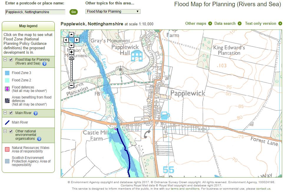
22 22

23 Surface water flooding potential poses a limited constraint on future development opportunities within Papplewick. The Greater Nottingham and Ashfield Outline Water Cycle Study February 2010 prepared by Entec consultants, considers in more detail the likely water related constraints and impacts of the development levels set out for Greater Nottingham and Ashfield. In relation to Papplewick it does not identify any specific findings. A number of documents have been prepared regarding the issues associated with a review of the Green Belt. The methodology framework was prepared by Ashfield, Broxtowe, Gedling and Nottingham City Councils to establish a common means of assessing the purposes of the Green Belt as part of a robust assessment of Green Belt boundaries within their area. If required, more detailed methodologies informed by local circumstances will be set out by each local authority in their Green Belt review documents. Gedling has undertaken an assessment of broad areas and specific sites against the purposes of the Green Belt. The Green Belt Assessment does not itself determine whether or not land is included in the Green Belt or not. It is the role of the Local Planning Document to formally revise Green Belt boundaries and to allocate land for development. 23

24 This assessment continues to identify Papplewick as a village washed over by the Green Belt. It states: The Green Belt around Papplewick is valuable in achieving the purposes of the Green Belt in particular due to the narrow gaps with nearby settlements and the historic character of the area. Broad Areas to the east are of lower value as there is less risk of coalescence with other settlements Papplewick is a traditional linear village with a mix of open and less open areas such that parts of the settlement contribute to the openness of the Green Belt. Gedling Borough Council Crown Copyright OS Licence No. LA

25 Gedling Borough Council Crown Copyright OS Licence No. LA

26 The assessment identifies scores, lower scores mean that a site or general area is, overall, less valuable in terms of the Green Belt. Whilst a site may have a low overall score, it may score particularly highly for one single Green Belt purpose. In these instances, it could be considered to be of sufficient importance on that one single purpose for the site to be retained as Green Belt. This will be particularly important for the following Green Belt purposes: Check the unrestricted sprawl of settlements. Prevent neighbouring towns from merging into one another. Preserve the setting and special character of historic settlements. Whether sites are so important for one of the Green Belt purposes that they should not be removed from the Green Belt will be considered as part of making decisions about which sites should be allocated. No changes have been made to the Green Belt with regard to Papplewick. The Habitats Regulation Assessment (HRA) Screening Record was undertaken for the Core Strategies. This found that there could be potentially significant effects on parts of the prospective Sherwood Forest Special Protection Area. It concluded that a precautionary approach should be followed and that policies should not encourage further visitors to this part of the Greenwood Community Forest. Supplementary Screening Records in reference to Calverton and Top Wighay Farm in Gedling were subsequently undertaken. The Screening Record for Top Wighay concluded that the scale of development would not be likely to have significant impact on any European site. Potential effects on the Sherwood Forest prospective Special Protection Area could not be ruled out. Following consultation with Natural England, a number of appropriate mitigation measures are identified and required to be in place to avoid significant effects from development at Calverton. No measures are required in Papplewick. 26
27 Growth and Infrastructure The Greater Nottingham Infrastructure Delivery Plan, considers infrastructure requirements related to the Core Strategies of Broxtowe, Erewash, Gedling, Nottingham and Rushcliffe Councils. It seeks to ascertain what additional infrastructure is needed to support the level of growth, when it is required and the resources needed to deliver it. The report also considers the viability of strategic sites, as there are no allocations proposed in Papplewick it does not set out any definitive recommendations for the Parish. Parking Provision for Residential Developments Supplementary Planning Document from 2012 sets out to ensure that new development is supported by the appropriate level of parking provision to accommodate demand, without exceeding demand which would lead to poorly designed developments that are dominated by the car, and without resulting in a shortfall which could lead to potential problems for highway safety. The Gedling Replacement Local Plan 2005 The Local Plan, which was adopted on 12 July 2005, provides the current planning framework for the Borough alongside the Aligned Core Strategy. The Local Plan will be replaced by the emerging Local Planning Document once it is adopted. The Local Plan identified particular areas as suitable for housing, industry, retail and other uses. It also includes specific policies to control the location and design of development within the Borough and to protect its heritage and local character. Planning applications are assessed against the Local Plan. The Local Plan identifies a number of designations which are relevant to the Papplewick Neighbourhood Plan including: Nottingham and Derby Green Belt Protected Open Space Sherwood Forest Sites of Importance for Nature Conservation 27

28 Extract from Replacement Local Plan Proposals Map 28
29 29
30 Statutory Heritage Records The Statutory list of Listed Buildings cites the following in Papplewick: Grade I Papplewick Hall, off Blidworth Waye (Formerly Main Street) Church of St. James, Church Lane Grade II* Engine House, Boiler House and workshop at Papplewick Pumping Station, Longdale Lane Grade II Chetwynd House and Boundary Wall, off Blidworth Waye (Formerly Main Street) Stable range at Papplewick Hall off Blidworth Waye, (Formerly Main Street) Walled kitchen garden 100 metres north of Papplewick Hall, Off Blidworth Waye Top Farmhouse and adjoining stables, Blidworth Waye Barn and stable at Top Farmhouse, Blidworth Waye Gate piers and boundary wall, Church of St. James, Church Lane 2 headstones 8 metres south-east of south porch, Church of St. James, Church Lane Chest tomb 8 metres south of south porch, Church of St. James, Church Lane 3 headstones 10 metres south of Tower, Church of St. James, Church Lane Obelisk 20 metres north-west of Vincent Lodge, Forest Lane The Griffins Head, Forest Lane 1 and The Barn, Linby Lane Boiler house chimney at Papplewick Pumping Station Smithy, stable and cartshed at Papplewick Pumping Station Cooling pond at Papplewick Pumping Station (Formerly listed as Retaining Walls to Reservoir) Deputy's house at Papplewick Pumping Station Superintendent's house at Papplewick Pumping Station Boundary wall and gates at Papplewick Pumping Station 9a, 9b, 11,15, 17, 19, 21, 23, 25 Main Street 49 (Pembroke Cottage), 51 and 53 Main Street The Old Post Office, 55 Main Street Morton's Farmhouse, 57 Main Street Stable and garage to south of Morton's Farm, Main Street Papplewick Lodge and adjoining stables, Main Street Sundial 16 metres north of Papplewick Lodge, Main Street 67, 69, 71,73 Main Street (Formerly listed as Nos 68-71) Howe Plantation Obelisk, 70 metres north-east of Woodland Grange, Mansfield Road Boundary stone 500 yards west of Mansfield Road Boundary stone 30 metres north of Howe Plantation Obelisk, Mansfield Road Boundary stone to north of Papplewick Pumping Station, Longdale Lane, at SK Boundary stone to north of Papplewick Pumping Station, Longdale Lane, at SK Boundary stone at entrance to Newstead Grange at SK The Statutory list of Ancient Monuments cites the following in Papplewick: Papplewick Pumping Station 30
31 The Statutory list of Historic Parks and Gardens cites the following in Papplewick: Grade II* Papplewick Hall Grade II Papplewick Pumping Station The Conservation Area Appraisal identifies the following local heritage designations: Buildings of Local Interest Gateway to Papplewick Hall, Blidworth Waye Wheelwrights Cottage, 30 Main Street West View Farmhouse and adjoining outbuildings, 46 Main Street Other Significant Buildings Gardener's Cottage, Hall Lane Ward Cottage, Blidworth Waye 11 Linby Lane The Nottinghamshire Minerals Local Plan 2016 The Minerals Local Plan was published for consultation during February and March Whilst the Papplewick Neighbourhood Plan cannot address any minerals or waste matters by law, existing or proposed minerals and waste proposals may impact upon other planning issues being addressed in the Neighbourhood Plan. The Bestwood 2 site which has consent for the extraction of Sherwood Sandstone through to 2023 lies partly within the Parish of Papplewick. A proposed eastern extension lies outside but immediately adjacent to the Parish of Papplewick. 31

32 Nottinghamshire County Council 32

33 Papplewick Neighbourhood Plan Issues Scoping Document February 2017 Papplewick Neighbourhood Plan is led by a Partnership of local organisations including Papplewick Parish Council and local residents For More information: Papplewick Parish Council
Papplewick Neighbourhood Plan
 Papplewick Neighbourhood Plan Papplewick Parish Council Issues Scoping Document & Evidence Base February 2017 Papplewick Neighbourhood Plan 2017-2028 Issues Scoping Document & Evidence Base February 2017
Papplewick Neighbourhood Plan
 Papplewick Neighbourhood Plan Papplewick Parish Council SEA & HRA Screening September 2017 Papplewick Neighbourhood Plan 2017-2028 Strategic Environmental Assessment and Habitats Regulation Assessment
Linby Neighbourhood Plan Masterplan Safeguarded Land Top Wighay Farm March Linby Neighbourhood Development Plan Masterplan 1
 Linby Neighbourhood Plan Masterplan Safeguarded Land Top Wighay Farm March 2017 Linby Neighbourhood Development Plan Masterplan 1 Linby Neighbourhood Development Plan Masterplan 2 Contents: Section 1:
Sustainability. Calverton Neighbourhood Plan. SEA Screening Statement & HRA
 Sustainability Calverton Neighbourhood Plan SEA Screening Statement & HRA November 2016 Calverton Neighbourhood Plan 2016-2028 Submission Plan Submitted to Gedling Borough Council in accordance with Regulation
LONGDEN VILLAGE DEVELOPMENT STATEMENT
 LONGDEN VILLAGE DEVELOPMENT STATEMENT 2017-2027 1 Longden Development Statement 2017-2027 15/01/18 1. Background 1.1 Longden Village Longden village is a very rural and traditional community first mentioned
Newcourt Masterplan. November Exeter Local Development Framework
 Newcourt Masterplan November 2010 Exeter Local Development Framework Background The Exeter Core Strategy Proposed Submission sets out the vision, objectives and strategy for the development of Exeter up
ROCHFORD LOCAL DEVELOPMENT FRAMEWORK: Sustainability Appraisal/ Strategic Environmental Assessment. Rochford Core Strategy Preferred Options Document
 ROCHFORD LOCAL DEVELOPMENT FRAMEWORK: Sustainability Appraisal/ Strategic Environmental Assessment Non Technical Summary Rochford Core Strategy Preferred Options Document October 2008 SUSTAINABILITY APPRAISAL
Parish of Repton NEIGHBOURHOOD DEVELOPMENT PLAN
 Parish of Repton NEIGHBOURHOOD DEVELOPMENT PLAN BASIC CONDITIONS STATEMENT December 2018 CEF 4 Legal Requirements This statement has been produced by the NDP Working Group on behalf of Repton Parish Council
INTRODUCTION NORTH HEYBRIDGE GARDEN SUBURB
 INTRODUCTION This event is being hosted by the promoters of the proposed North Heybridge Garden Suburb who are working with Maldon District Council and other key stakeholders on the preparation of a comprehensive
Copyright Nigel Deeley and licensed for reuse under this Creative Commons Licence
 1 Copyright Nigel Deeley and licensed for reuse under this Creative Commons Licence Prepared by the Neighbourhood Plan Steering Group on behalf of Garway Parish Council with assistance from 2 Table of
Statement of Community Involvement LAND OFF SOUTHDOWN ROAD HORNDEAN, HAMPSHIRE
 LAND OFF SOUTHDOWN ROAD HORNDEAN, HAMPSHIRE CONTENTS Page 1. Introduction 3 2. Pre-application Discussions 4 3. The Consultation Process 5 4. Consultation Feedback 7 5. Responses to Consultation Feedback
3. Neighbourhood Plans and Strategic Environmental Assessment
 1. Introduction This report sets out a draft Screening Determination for the Preston Parish Council s Neighbourhood Plan and has been prepared by rth Hertfordshire District Council. The purpose of the
Site Assessment Technical Document Appendix A: Glossary
 Central Bedfordshire Council www.centralbedfordshire.gov.uk Site Assessment Technical Document Appendix A: Glossary July 2017 1.1.11-1 - ii Appendix A: Glossary Term Agricultural Land Classification AONB
Settlement Boundaries Methodology North Northumberland Coast Neighbourhood Plan (August 2016)
") Introduction This background paper sets out a methodology for the definition of settlement boundaries in the North Northumberland Coast Neighbourhood Plan. The neighbourhood plan is planning positively
Introduction This background paper sets out a methodology for the definition of settlement boundaries in the North Northumberland Coast Neighbourhood Plan. The neighbourhood plan is planning positively
Effingham Neighbourhood Plan 1. Basic Conditions Statement
 Effingham Neighbourhood Plan 1 Basic Conditions Statement Effingham Neighbourhood Plan 2016: Basic Conditions Statement 2 Contents This statement has been prepared by Effingham Parish Council to accompany
Plumpton Neighbourhood Plan Site Assessment Report
 Plumpton Neighbourhood Plan Site Assessment Report May 2016 1 Contents 1. Introduction 3 2. Methodology 4 2.1 Identification of Potential Sites 4 2.2 Assessment Process 5 2.3 Assessment Criteria 6 2.4
Public Consultation 23 January Peel Hall, Warrington Board 1. A message from Satnam... Site history...
 Board 1 A message from Satnam... Thank you for attending today s public consultation about proposals to develop a new residential neighbourhood at. The display boards show why the development is needed
Wallingford Neighbourhood Plan
 Wallingford Neighbourhood Plan Introduction What is neighbourhood planning? Neighbourhood planning was introduced by the Localism Act 2011 to give local people more influence over how development comes
Land at Rampton Road. Cottenham
 Land at Rampton Road Cottenham Introduction TEP is preparing an outline planning application for 54 dwellings on 6.9 hectares of land adjacent to Rampton Road, Cottenham on behalf of the owners Cambridgeshire
Habitat Regulations Assessment (HRA) Screening Determination. May 2017
 Screening Determination. May 2017") Cholsey Parish Council Cholsey Neighbourhood Plan Habitat Regulations Assessment (HRA) Screening Determination May 2017 Cholsey Neighbourhood Plan Page! 1 of! 10 SASR - HRA v1.1 Page Left Intentionally
Cholsey Parish Council Cholsey Neighbourhood Plan Habitat Regulations Assessment (HRA) Screening Determination May 2017 Cholsey Neighbourhood Plan Page! 1 of! 10 SASR - HRA v1.1 Page Left Intentionally
Perth and Kinross Council Development Management Committee 8 June Pre-Application Report by Development Quality Manager
 Perth and Kinross Council Development Management Committee 8 June 2016 5(3)(i) 16/259 Pre-Application Report by Development Quality Manager Residential development at St Martins Road, Land 120 metres West
BEDFORD BOROUGH COUNCIL PLAN IMPLEMENTATION MONITORING REPORT
 BEDFORD BOROUGH COUNCIL PLAN IMPLEMENTATION MONITORING REPORT 2017-18 Summary 1 Progress on local development documents 1 Local development documents adopted in the monitoring period 1st April 2017 31st
Reserved Matters application for a site that straddles the boundary between CBC and BBC
 BBC APPLICATION 15/02682/MAR NUMBER CBC APPLICATION CB/15/04294/RM NUMBER LOCATION Wixams Land at former storage depot, Bedford Road, Wilstead Bedfordshire PROPOSAL Reserved Matters Application for Strategic
Kibworth Harcourt. Introduction. Introduction
 Introduction Introduction Welcome to this public exhibition on the proposals for the delivery of new homes on land at The Kibworths. The purpose of today s exhibition is to give you the opportunity to
Copyright Nigel Deeley and licensed for reuse under this Creative Commons Licence
 1 Copyright Nigel Deeley and licensed for reuse under this Creative Commons Licence Prepared by the Neighbourhood Plan Steering Group on behalf of Garway Parish Council with assistance from 2 Table of
Plumpton Neighbourhood Development Plan Revised Pre Submission Document - Regulation 14 Consultation
 REPRESENTATIONS... Plumpton Parish Council Plumpton Neighbourhood Development Plan Revised Pre Submission Document - Regulation 14 Consultation Representations submitted on behalf of: Cala Homes (South
Draft Hailey Neighbourhood Plan
 Persimmon Homes (Wessex) Draft Hailey Neighbourhood Plan Representations to West Oxfordshire District Council s Regulation 16 Consultation December 2018 2 Copyright 2018 Persimmon Homes Ltd. All rights
Examination of South Cambridgeshire Local Plan
 Matter SC6A - Policy SS/5 Waterbeach New Town Historic England( formerly English Heritage) 874 Rep Nos 59748, 60250, 60253 Examination of South Cambridgeshire Local Plan Historic England, Hearing Statement
Sustainability Statement. Whitby Business Park Area Action Plan
 Sustainability Statement Whitby Business Park Area Action Plan November 2014 Contents Page 1. Introduction 1 2. Scoping 3 3. Sustainability Appraisal of Options 6 4. Assessment of Draft Area Action Plan
WELCOME TO THE NEW WILTON PARK
 WELCOME TO THE NEW WILTON PARK VISION HISTORY OF WILTON PARK TOWARDS A PLANNING APPLICATION Our objective is to create a truly outstanding environment at Wilton Park. At the heart of our proposals is a
Welcome to our exhibition
 Welcome to our exhibition The Homes & Communities Agency (HCA) welcomes you to this public exhibition explaining our proposals for the redevelopment of the former Lea Castle Hospital site. About the Homes
GUILDFORD BOROUGH GREEN BELT AND COUNTRYSIDE STUDY
 GUILDFORD BOROUGH GREEN BELT AND COUNTRYSIDE STUDY Volume II - Addendum On behalf of Guildford Borough Council PPG Ref : BNL.0287 April 2014 COPYRIGHT The conents of this document must not be copied or
LEEDS SITE ALLOCATIONS PLAN MATTER 3 GREEN BELT KCS DEVELOPMENT AUGUST 2017
 LEEDS SITE ALLOCATIONS PLAN MATTER 3 GREEN BELT KCS DEVELOPMENT AUGUST 2017 Smith Limited Suite 9C Joseph s Well Hanover Walk Leeds LS3 1AB T: 0113 2431919 F: 0113 2422198 E: planning@peacockandsmith.co.uk
Neighbourhood Plan Representation
 Date: 10 th November 2017 Neighbourhood Plan Representation Land to the east of Callow Hill Road, Alvechurch Introduction This representation has been prepared by RPS Planning and Development on behalf
Neighbourhood Planning Local Green Spaces
 Neighbourhood Planning Local Green Spaces Introduction... 2 1. Why green space is important... 4 2. Neighbourhood plans and green space... 6 3. Evidence... 8 Statutory designations... 9 Green space audit...
Public Consultation. Land at Monks Farm, North Grove. Welcome
 Welcome Welcome to our public exhibition for development on Land at Monks Farm, orth Grove. Gallagher Estates and Gleeson Strategic Land are preparing an outline planning application for new homes, open
Oxford Green Belt Study. Summary of Final Report Prepared by LUC October 2015
 Oxford Green Belt Study Summary of Final Report Prepared by LUC October 2015 Project Title: Oxford Green Belt Study Client: Oxfordshire County Council Version Date Version Details Prepared by Checked by
UTT/16/1466/DFO GREAT DUNMOW MAJOR
 UTT/16/1466/DFO GREAT DUNMOW MAJOR PROPOSAL: LOCATION: APPLICANT: AGENT: Reserved matters approval for the accesses to the site and principal roads within the site including spine road following outline
Local Development Scheme
 Local Development Scheme 2012 2016 The Local Development Scheme (LDS) is a project plan that outlines how and when the Authority will update its planning policies and other associated documents. It ensures
UTT/17/2075/FUL - (BERDEN) (Referred to Committee by Councillor Janice Loughlin. Reason: In the Public Interest)
 (Referred to Committee by Councillor Janice Loughlin. Reason: In the Public Interest)") UTT/17/2075/FUL - (BERDEN) (Referred to Committee by Councillor Janice Loughlin. Reason: In the Public Interest) PROPOSAL: LOCATION: APPLICANT: Amendments to the design of a scheme for a 49.99MW battery
UTT/17/2075/FUL - (BERDEN) (Referred to Committee by Councillor Janice Loughlin. Reason: In the Public Interest) PROPOSAL: LOCATION: APPLICANT: Amendments to the design of a scheme for a 49.99MW battery
Everton s Neighbourhood Plan. Site Allocation - Assessment Criteria
 Everton s Neighbourhood Plan Site llocation - ssessment Criteria Introduction 1.1 This report assesses all the sites identified through the emerging Neighbourhood Plan for Everton and their potential for
Ebbsfleet Development Corporation
 Title of Paper Planning and Housing Delivery Report September 2018 Presented by Sub-Committee Mark Pullin, Chief Planning Officer Planning Committee Purpose of Paper and Executive Summary This paper provides
Briefing Document of CNP. June 2017
 Cholsey Parish Council Cholsey Neighbourhood Plan Briefing Document of CNP June 2017 Cholsey Neighbourhood Plan Page! 1 of! 8 Cholsey Plan Briefing v1.4 Page Left Intentionally Blank Cholsey Neighbourhood
SOUTH CAMBRIDGESHIRE DISTRICT COUNCIL. Planning and New Communities Director
 SOUTH CAMBRIDGESHIRE DISTRICT COUNCIL REPORT TO: Planning Committee 5 June 2013 AUTHOR/S: Planning and New Communities Director S/0747/13/FL HISTON Construction of Car Park at Histon Baptist Church, Station
Cookham Parish Council s Response to The Draft Local Borough Plan
 Cookham Parish Council s Response to The Draft Local Borough Plan As Agreed at the Planning Committee Meeting on 10 th January 2017. Designation of Poundfield as a Local Green Space The Parish Council
Sutton cum Lound Neighbourhood Plan
 Sutton cum Lound Parish Neighbourhood Plan 2016-2031 Pre-Submission Consultation Version Sutton cum Lound Neighbourhood Plan 2016-2031 Sutton cum Lound Neighbourhood Plan Steering Group on behalf of Sutton
DEVELOPMENT MANAGEMENT REPORT
 ITEM A07-1 DEVELOPMENT MANAGEMENT REPORT TO: BY: Development Management Committee (South) Development Manager DATE: 21 June 2016 DEVELOPMENT: SITE: WARD: APPLICATION: APPLICANT: Outline application for
Welcome. Land adjacent Sandy Lane WALTHAM CHASE THE PROPOSED SITE
 Land adjacent Sandy Lane WALTHAM CHASE Existing Linden Homes developments Welcome Welcome to Linden Homes Southern s ( Linden ) public exhibition about its proposals for a range of high-quality homes for
Wildlife and Planning Guidance: Neighbourhood Plans
 Wildlife and Planning Guidance: Neighbourhood Plans This Leaflet is one of a series of 4 Wildlife and Planning Guidance Leaflets and is intended to provide useful information to assist you to campaign
an Inspector appointed by the Secretary of State for Communities and Local Government
 Appeal Decision Site visit made on 23 January 2017 by Gareth Wildgoose BSc (Hons) MSc MRTPI an Inspector appointed by the Secretary of State for Communities and Local Government Decision date: 6 February
Test Valley Borough Council. Strategic Housing Land Availability Assessment (SHLAA)
") Test Valley Borough Council Strategic Land Assessment (SHLAA) Appendix 2 Southern Test Valley Sites Where a Change in Policy is Required for Residential Development Final Version as at 1 st April 2014
Test Valley Borough Council Strategic Land Assessment (SHLAA) Appendix 2 Southern Test Valley Sites Where a Change in Policy is Required for Residential Development Final Version as at 1 st April 2014
About 10% of the Borough's population lives in the seven rural parishes. Population figures from the 1991 census are given below:-
 8. THE DISTRICT VILLAGES 8.1 Population About 10% of the Borough's population lives in the seven rural parishes. Population figures from the 1991 census are given below:- Village No. of Persons Cottingham
Neighbourhood Planning Site Assessment Pro-forma and Guide Version 2
 Neighbourhood Planning Site Assessment Pro-forma and Guide Version 2 September 2014 Site HNP 006 Land East of Stanbridge Road and North of Lower Road 1. Background information Site location and use Site
WELCOME GYPSY LANE. Wider Site Location plan. Proposals for the development of LAND OFF FOXLYDIATE LANE WEBHEATH. Proposals for the development of
 WELCOME The developers are preparing an outline planning application for a residential led development and need the community s views in order to develop the proposals further WHAT IS PROPOSED? A high
3(iv)(b) TCP/11/16(29)
(b) TCP/11/16(29)") 3(iv)(b) TCP/11/16(29) TCP/11/16(29) Planning Application 09/02229/AML Erection of a dwellinghouse, garage with upper floor accommodation and stables (Approval of Matters Specified by Conditions) at land
3(iv)(b) TCP/11/16(29) TCP/11/16(29) Planning Application 09/02229/AML Erection of a dwellinghouse, garage with upper floor accommodation and stables (Approval of Matters Specified by Conditions) at land
Joint Core Strategy Rushden Sustainable Urban Extension
 Date Page 1 of 18 Report Originator Title Planning Manager Joint Core Strategy Rushden Sustainable Urban Extension 1. PURPOSE OF REPORT 1.1 To consider representations received on the emerging Joint Core
Great Easton Neighbourhood Plan Statement of Basic Conditions
 Great Easton Neighbourhood Plan 2017-2031 Statement of Basic Conditions OCTOBER 2016 GREAT EASTON PARISH COUNCIL Contents 1.0 Introduction....Page 2 2.0 Summary of Submission Documents and Supporting Evidence..
Welford-on-Avon Neighbourhood Plan Consultation Event Sunday, 6 April Your name Your address
 Welford-on-Avon Neighbourhood Plan Consultation Event Sunday, 6 April 2014 Your name Your email address Please either: - complete this feedback form and put it in the box before leaving the Memorial Hall
DUNSFOLD NEIGHBOURHOOD PLAN Site Selection Policies
 DUNSFOLD NEIGHBOURHOOD PLAN Site Selection Policies The criteria for assessing sites for future housing and business development in Dunsfold are set out below. (Development criteria, covering what it is
Urban Growth Boundaries
 Urban Growth Boundaries Discussion Document July 2008 Contents page Introduction... 3 What are urban growth boundaries?... 3 The need to manage growth... 3 Purpose of urban growth boundaries... 4 How will
REFERENCE: B/03745/12 Received: 02 October 2012 Accepted: 05 October 2012 WARD(S): Totteridge Expiry: 30 November 2012.
: Totteridge Expiry: 30 November 2012.") LOCATION: 15A Pyecombe Corner, London, N12 7AJ REFERENCE: B/03745/12 Received: 02 October 2012 Accepted: 05 October 2012 WARD(S): Totteridge Expiry: 30 November 2012 Final Revisions: APPLICANT: PROPOSAL:
LOCATION: 15A Pyecombe Corner, London, N12 7AJ REFERENCE: B/03745/12 Received: 02 October 2012 Accepted: 05 October 2012 WARD(S): Totteridge Expiry: 30 November 2012 Final Revisions: APPLICANT: PROPOSAL:
1. Objectives of this consultation
 1. Objectives of this consultation Provide an update on the results of the December 2014 consultation Provide a summary of the Pre-Submission Plan which is now out for formal consultation To ask for your
SPG 1. * the northern and western sections which are open fields used for pasture and grazing;
 SPG 1 1.0 INTRODUCTION This development brief is based on the allocation of the Priors Hall site for employment and countryside recreational purposes in the Corby Borough Local Plan. The brief is intended
Wildlife and Planning Guidance: Local Plans
 Wildlife and Planning Guidance: Local Plans This Leaflet is one of a series of 4 Wildlife and Planning Guidance Leaflets and is intended to provide useful information to assist you to campaign effectively
Stanton Drew Parish Neighbourhood Plan Landscape and Environment
 Contents Introduction... 2 Scope of the Document... 2 Our Definition of a View... 2 Proposed Policies... 3 Criteria for a Protected View... 3 Views Assessed... 4 View 1: from cricket ground north towards
The Gwennap Parish Vision Statement
 QUICK GUIDE What is a Neighbourhood Development Plan? Ultimately it is a document used by developers or anyone wishing to submit a planning application that describes the vision, strategy, plans, regeneration,
Former North Works, Lickey Road, Longbridge, Birmingham
 Committee Date: 14/11/2013 Application Number: 2013/06431/PA Accepted: 27/08/2013 Application Type: Full Planning Target Date: 26/11/2013 Ward: Longbridge Former North Works, Lickey Road, Longbridge, Birmingham
Persimmon Homes Thames Valley Date received: 2 nd April week date(major): 2 nd July 2014 Ward: Nascot
: 2 nd July 2014 Ward: Nascot") PART A Report of: DEVELOPMENT MANAGEMENT SECTION HEAD Date of Committee: 26 th June 2014 Site address: Rounton, 28, Nascot Wood Road Reference Number: 14/00497/REM Description of Development: Reserved
PART A Report of: DEVELOPMENT MANAGEMENT SECTION HEAD Date of Committee: 26 th June 2014 Site address: Rounton, 28, Nascot Wood Road Reference Number: 14/00497/REM Description of Development: Reserved
Perth and Kinross Council Development Management Committee 20 February 2013 Report of Handling by Development Quality Manager
 Perth and Kinross Council Development Management Committee 20 February 2013 Report of Handling by Development Quality Manager 4(4)(iii) 13/81 Erection of sports hall, associated changing facilities, offices
Calverton Neighbourhood Plan. Submission Plan. The Plan
 Calverton Neighbourhood Plan Submission Plan The Plan November 2016 Calverton Neighbourhood Plan 2016-2028 Calverton Neighbourhood Plan Submission Version - November 2016 Submission Plan Submitted to Gedling
SOUTH CAMBRIDGESHIRE DISTRICT COUNCIL. REPORT TO: Planning Committee 1 April 2015 Planning and New Communities Director
 SOUTH CAMBRIDGESHIRE DISTRICT COUNCIL REPORT TO: Planning Committee 1 April 2015 AUTHOR/S: Planning and New Communities Director Application Number: Parish(es): Proposal: Site address: Applicant(s): Recommendation:
WHITELEY TOWN COUNCIL NORTH WHITELEY DEVELOPMENT SEPTEMBER 2014
 WHITELEY TOWN COUNCIL NORTH WHITELEY DEVELOPMENT SEPTEMBER 2014 Dear Resident This Special Edition of the Whiteley Voice which has been prepared in conjunction with the North Whiteley Consortium is to
Chapter 2: OUTLINE PLANNING APPLICATION PROPOSALS. A New Garden Neighbourhood Matford Barton 17
 Chapter 2: OUTLINE PLANNING APPLICATION PROPOSALS A New Garden Neighbourhood Matford Barton 17 2.1. SUMMARY AND STATUS OF THE PROPOSALS 2.1.1. The parameter plans and associated wording in this chapter
Replacement Golf Course Facilities and Residential Development, Churston. Environmental Statement Non-Technical Summary
 Replacement Golf Course Facilities and Residential Development, Churston Environmental Statement Non-Technical Summary July 2011 Reproduced from the Ordnance Survey s map with the permission of the Controller
ALLERTHORPE NEIGHBOURHOOD PLAN
 Allerthorpe s Neighbourhood Plan sets out a vision for the Parish for the next 15 years (2018 2033) that builds on and reflects the opinions and views of parish residents. VISION In 2033 Allerthorpe will
Blenheim Lane. Nottingham Energy Park. Informal Planning Guidance January Approved By: Portfolio Holder for Planning & Transportation
 Blenheim Lane Former Allotments Site Nottingham Energy Park Approved By: Portfolio Holder for Planning & Transportation Informal Planning Guidance January 2012 Cities Revealed Copyright by The Geoinformation
Balcombe Neighbourhood Plan. Habitats Regulations Assessment Screening Report
 Balcombe Neighbourhood Plan Habitats Regulations Assessment Screening Report Produced for Regulation 14 of the Neighbourhood Planning (General) Regulations 2012 17 th July 2015 1.0 Introduction 1.1 This
Ipswich Issues and Options for the Ipswich Local Plan Review, August 2017, Public Consultation
 Ipswich Issues and Options for the Ipswich Local Plan Review, August 2017, Public Consultation Having reviewed the issues and options documents, the Society has made the following response: Part 1 Strategic
Linden Homes Proposals for land off Ringwood Road, Verwood
 Welcome Welcome to Linden Homes first public exhibition displaying proposals for new homes on land off Ringwood Road in Verwood. Award-winning house builder Linden Homes, part of the Galliford Try Group,
DEVELOPMENT MANAGEMENT REPORT
 ITEM A08-1 DEVELOPMENT MANAGEMENT REPORT TO: BY: DATE: DEVELOPMENT: SITE: WARD: APPLICATION: APPLICANT: Development Management Committee Development Manager Proposed live/work unit in connection with existing
SOUTH EAST LINCOLNSHIRE LOCAL PLAN: HOUSING PAPER DONINGTON (JUNE 2016)
") SOUTH EAST LINCOLNSHIRE LOCAL PLAN: HOUSING PAPER DONINGTON (JUNE 2016) 1 DONINGTON S PLACE IN THE SPATIAL STRATEGY 1.1 Policy 2 of the South East Lincolnshire Local Plan 2011-2036 Draft for Public Consultation
SOUTH EAST LINCOLNSHIRE LOCAL PLAN: HOUSING PAPER DONINGTON (JUNE 2016) 1 DONINGTON S PLACE IN THE SPATIAL STRATEGY 1.1 Policy 2 of the South East Lincolnshire Local Plan 2011-2036 Draft for Public Consultation
Brookside Walk Children's Play Area, London, NW4
 LOCATION: Brookside Walk Children's Play Area, London, NW4 REFERENCE: H/05584/13 Received: 26 November 2013 Accepted: 11 December 2013 WARD(S): Hendon Expiry: 05 February 2014 Final Revisions: APPLICANT:
DRAFT STRATEGIC ENVIRONMENTAL ASSESSMENT REPORT
 DRAFT STRATEGIC ENVIRONMENTAL ASSESSMENT REPORT Published by Limpsfield Parish Council in accordance with EU Directive 2001/42 on Strategic Environmental Assessment and with the Environmental Assessment
Welford-on-Avon. Neighbourhood Development Plan Welford-on-Avon Parish Council
 Welford-on-Avon Neighbourhood Development Plan 2011-2031 Welford-on-Avon Parish Council Parish Consultation: Summary Version December 2014 January 2015 Foreword This is the latest version of the Welford
Former Temple Cowley Pools, Oxford TEMPLE COWLEY LIBRARY * ELEVATION SHOWN IS INDICATIVE AND SUBJECT TO FINAL DESIGN AND AGREEMENT.
 OPEN SPACE TEMPLE COWLEY LIBRARY library beyond Proposed apartments Proposed apartments Proposed houses Temple Road * ELEVATION SHOWN IS INDICATIVE AND SUBJECT TO FINAL DESIGN AND AGREEMENT. * Welcome
Schedule of Planning Applications Committee Date: 23 May Reference: 06/17/0726/F Parish: Hemsby Officer: Mr J Beck Expiry Date:
 Schedule of Planning Applications Committee Date: 23 May 2018 Reference: 06/17/0726/F Parish: Hemsby Officer: Mr J Beck Expiry Date: 22-05-2018 Applicant: Proposal: Site: Mr Gillett Change of use to the
Welcome to our Public Consultation
 About our development This exhibition gives you the chance to view and comment on our emerging plans for a proposed residential development located on land to the West of Alwyn Road, Rugby. Welcome to
CA//17/02777/FUL. Scale 1:1,250. Planning Services Canterbury City Council Military Road Canterbury Kent CT1 1YW
 O CA//17/02777/FUL Scale 1:1,250 Map Dated: 15/03/2018 Planning Services Canterbury City Council Military Road Canterbury Kent CT1 1YW AGENDA ITEM NO 16 PLANNING COMMITTEE APPLICATION NUMBER: SITE LOCATION:
Neighbourhood Planning Guidance Local Green Spaces
 Neighbourhood Planning Guidance Local Green Spaces Introduction This guidance note has been produced for communities preparing neighbourhood plans in North Dorset to help them to identify, assess and designate
EAST LANGTON PARISH NEIGHBOURHOOD PLAN. Submission version
 EAST LANGTON PARISH NEIGHBOURHOOD PLAN Submission version 2011 2031 Contents Chapter heading Page Introduction from Chair 3 1. Why Neighbourhood Plans are important 5 2. Why we need a Neighbourhood Plan
Appendix C. Members Pre-Consultation Briefing. Local Plan - Gypsy and Traveller Sites. January 2018
 Appendix C Members Pre-Consultation Briefing Local Plan - Gypsy and Traveller Sites January 2018 Subject to approval from Cabinet on the 30 th January 2018 Chesterfield Borough Council will shortly be
Planning and Regulatory Committee 20 May Applicant Local Councillor Purpose of Report
 Planning and Regulatory Committee 20 May 2014 7. APPLICATION FOR PLANNING PERMISSION FOR THE CARRYING-OUT OF DEVELOPMENT PURSUANT TO PLANNING PERMISSION REFERENCE NUMBER 603451 DATED 28 FEBRUARY 2007 WITHOUT
an Inspector appointed by the Secretary of State for Communities and Local Government
 Appeal Decision Site visit made on 6 November 2017 by Rachel Walmsley BSc MSc MA MRTPI an Inspector appointed by the Secretary of State for Communities and Local Government Decision date: 19 th January
Warren Farm, Ampthill
 1 Welcome The developers of the Warren Farm site, Bloor Homes and Connolly Homes, are holding this exhibition on the emerging Design Codes for the development prior to their formal submission to Central
STATEMENT OF OBJECTION TO THE PROPOSED DEVELOPMENT OF LAND AT CHURCH CLIFF DRIVE FILEY
 STATEMENT OF OBJECTION TO THE PROPOSED DEVELOPMENT OF LAND AT CHURCH CLIFF DRIVE FILEY You will be aware that Scarborough borough council have adopted a new local plan that includes land at Church Cliff
Repton Parish Neighbourhood Development Plan - Consultation March 2017
 Repton Parish Neighbourhood Development Plan - Consultation March 2017 25 replies Policy No Comments Response H1 Agree 22 Amend to include Milton Road & footpath but exclude above footpath. Neither agree
Great Easton Sustainable Housing Development Sites - Site Seven, Broadgate extension site SHLAA Ref HSG/03)
") Great Easton Sustainable Housing Development Sites - Site Seven, Broadgate extension site SHLAA Ref HSG/03) 1. Introduction The Great Easton Neighbourhood Plan Group are preparing a Neighbourhood Plan
Great Easton Sustainable Housing Development Sites - Site Seven, Broadgate extension site SHLAA Ref HSG/03) 1. Introduction The Great Easton Neighbourhood Plan Group are preparing a Neighbourhood Plan
Response by The Dartington Hall Trust
 Consultation Response by The Dartington Hall Trust Site Reference: SH_39_02_08/13 Contents Introduction 1 Site Description 2 Development Proposal and Context 3 Site Technical Assessment 4 Planning Policy
Reporter: Section 3 Place, Drymen, pp reference: Body or person(s) submitting a representation raising the issue (including reference number):
 submitting a representation raising the issue (including reference number):") Issue 10 Drymen Development plan Reporter: Section 3 Place, Drymen, pp.66-69 reference: Body or person(s) submitting a representation raising the issue (including reference number): Nadja Ray (85) Stuart
Issue 10 Drymen Development plan Reporter: Section 3 Place, Drymen, pp.66-69 reference: Body or person(s) submitting a representation raising the issue (including reference number): Nadja Ray (85) Stuart
Proposed Sheffield City Region Combined Green Belt Review A Common Approach August 2014
 Proposed Sheffield City Region Combined Green Belt Review A Common Approach August 2014 1.1 Purpose To achieve the principles of Duty to Cooperate, it is beneficial for all Local Authorities within the