State Route 6 Corridor Study Final Report
|
|
|
- Franklin Eaton
- 6 years ago
- Views:
Transcription


1 D R A F T State Route 6 Corridor Study Final Report Atlanta Regional Commission
2 State Route 6 Corridor Study Final Report Prepared for: Atlanta Regional Commission Prepared by: URS Corporation 1000 Abernathy Road, Suite 900 Atlanta, Georgia In Association with: Joel F. Stone, Jr. Inc. Market+Main Inc. Michael Ronkin PEQ: Planners for Environmental Quality Ralph Whitehead Associates Schapiro Research Group Urban Collage, Inc. URS Project Number:
3 ACKNOWLEDGEMENTS Study Partners City of Powder Springs Cobb County Douglas County Fulton County Paulding County Stakeholder Advisory Committee Participant Organizations Chattahoochee Technical College City of Austell City of College Park City of College Park Economic Development City of College Park Public Works City of East Point City of East Point Residents City of Hiram Cobb Chamber of Commerce Cobb County Community Development Douglas County Chamber of Commerce Duke Realty Corporation Fulton Industrial District Georgia International Convention Center Georgian Bank Hartsfield Jackson Atlanta International Airport Hartsfield Area Transportation Management Association Kroger Store Livable Communities Coalition MARTA Paulding Chamber of Commerce Paulding County Resident Sandtown Association South Fulton Chamber of Commerce South West Austell Neighbor Agencies Atlanta Regional Commission Georgia Department of Transportation Georgia Regional Transportation Authority Final Report
4 Table of Contents 1.0 SR 6 Study Introduction and Background Study Area Study Process Study Activities Study Documentation Public Engagement Activities SR 6 Corridor Overview Goals and Objectives Market and Development Trends Transportation Trends Identified Needs Alternatives Development Transportation and Land Use Alternatives Land Use Public Input SR 6 Corridor Recommendations ARC Planned and Programmed Projects Transportation Recommendations Roadway Capacity Roadway Operations, Traffic Management and Freight Transit Bicycle/Pedestrian Other Land Use Future Land Use Framework Planning Subareas Implementation Program and Considerations Envison6 RTP SR 6 Corridor Study Transportation Projects Implementation Considerations Appendices Appendix A: Public Outreach Documentation Appendix B: Norfolk Southern Settlement Agreements Final Report i
5 List of Figures Figure 1 1: SR 6 Corridor Study Area Figure 3 1: Roadway and Transit Recommendations Figure 3 2: Traffic Operations and Other Recommendations Figure 3 3: Proposed Typical Section Figure 3 4: Roadway with Rain Garden Typical Section Figure 3 5a: Sustainable Growth Framework Dallas to I Figure 3 5b: Sustainable Growth Framework I 20 to HJAIA Figure 3 6: Powder Springs West Figure 3 7: I 20 Interchange Figure 3 8: Camp Creek East List of Tables Table 1 1: General Public Outreach Efforts Table 1 2: Stakeholder and Leadership Meetings Table 3 1: ARC Envision6 RTP Planned and Programmed Projects within the SR 6 Study Area Table 3 2: SR 6 Corridor Projects Identified as Unfunded Regional Priorities in Envision Table 4 1: Envision6 Planned and Programmed Project Cost by Implementation Period Table 4 2: Envision6 Planned and Programmed Project Cost by Project Type Table 4 3: Estimated Costs for Recommended SR 6 Corridor Transportation Projects Table 4 4: Potential Funding Sources Final Report ii
6 1.0 SR 6 Study Introduction and Background In early 2006, the Atlanta Regional Commission (ARC) initiated a corridor study for State Route Six (SR 6), a major regional travel corridor. The corridor study was proposed to address five major categories transportation, transit, land use urban design, corridor management, and financial programming and identify a series of recommendations for inclusion in the Regional Transportation Plan (RTP) and the Transportation Improvement Program (TIP). The study included identifying deficiencies within the study corridor, assessing benefits and costs of alternative strategies, and selecting a preferred alternative program of policies and projects within the financial constraints for the study area. This report serves as the final documentation for the study. Many organizations and persons participated in the corridor planning process. Representatives from local, regional, and state jurisdictions and agencies as well as interest groups and citizens were involved. A consulting team led by URS Corporation was retained to conduct the study. The project was sponsored by the ARC, along with matching contributions from local governments, including the four counties: Paulding, Cobb, Douglas, and Fulton as well as the City of Powder Springs. The Georgia Regional Transportation Authority (GRTA), Georgia Department of Transportation (GDOT), Metropolitan Atlanta Rapid Transit Authority (MARTA) and local governments were included as members of the Stakeholder Advisory Committee to ensure regional and local coordination. 1.1 Study Area The SR 6 corridor study area extends 32.5 miles from SR 61 in Paulding County to I 85 at Hartsfield Jackson Atlanta International Airport (HJAIA). The study area, shown in Figure 1 1, includes the lands buffering the corridor within one half mile on either side. The corridor traverses four counties (Paulding, Cobb, Douglas, and Fulton) and seven municipalities (the Cities of Hiram, Dallas, Powder Springs, Austell, Douglasville, East Point, and College Park). Final Report 1 1


7 'Baldwin Creek' STUDY AREA MAP PAULDING DOUGLAS COBB CHEROKEE FULTON FORSYTH GWINNETT DEKALB ROCKDALE 120 D a l l a s PAULDING SILV ER COMET TR AIL H i r a m 'Powder Springs Creek' 176 P o w d e r S p r i n g s 'Mud Creek' 'Noses Creek' COBB Norfolk Southern Whitaker Intermodal Terminal 'Olley Creek' S m y r n a 'Nickajack Creek' M a r i e t t a 285 'Poplar Creek' 'Rottenwood Creek' 'Long Island Creek' 'Nancy Creek' FAYETTE CLAYTON HENRY 92 'Gothards Creek' L i t h i a S p r i n g s A u s t e l l 'Peachtree Creek' COWETA Miles State Route 6 Silver Comet Trail Intermodal Terminal Interstate Highways State Highways Town Centers Activity Centers Rivers & Streams State Park Airports LEGEND Railroad Cities MARTA Stations MARTA Railways Segment 1 Segment 2 Segment 3 Segment 4 V i l l a R i c a 'Keaton Creek' 'Billy Creek' 'Town Brook' DOUGLAS 'Dog River' Miles 5 'Gothards Creek' 'Bear Creek' D o u g l a s v i l l e 'Tanyard Brook' 'Little Bear Creek' in 'Pea Creek' 'Anneewakee Creek' 92 'Crooked Creek' 6 Sweetwater Creek State Park 'Sweetwater Creek' D o u g l a s v i l l e 'Line Creek' 92 'Deep Creek' 20 'Chattahoochee River' 'Utoy Creek' FULTON 166 FULTON COUNTY AIRPORT 'North Utoy Creek' 'Camp Creek' 285 'South Utoy Creek' 'Proctor Creek' Arts Center Midtown Bankhead North Avenue Civic Center A t l a n t a Ashby West Lake Five Points Hamilton E. Holmes Vine City Garnett Georgia State West End Oakland City E a s t P o i n t C o l l e g e P a r k College Park 85 Lakewood-Ft. McPherson HARTSFIELD - JACKSON ATLANTA Airport INTL AIRPORT H a p e v i l l e CLAYTON STATE ROUTE 6 CORRIDOR STUDY Figure 1-1: Study Area Map
8 A major identifying character of the corridor is that the roadway is not referred to as SR 6. The common names for SR 6, designated by the various jurisdictions, and used by those who travel in the corridor are: US Highway 278 or 278 Paulding, Cobb, and Douglas Counties Jimmy Campbell Parkway Paulding County Jimmy Lee Smith Parkway Paulding County Wendy Bagwell Parkway Paulding County C.H. James Parkway Cobb and Douglas Counties Thornton Road Cobb County, Douglas County Camp Creek Parkway Fulton County To respond to the varying characteristics and needs of the corridor, the study area was divided into four individual segments for data reporting, analysis and alternatives development and testing: Segment 1 SR 61 to Norfolk Southern s Whitaker Intermodal Terminal at Westside Road (11.4 miles) Segment 2 Westside Road to I 20 (5.75 miles) Segment 3 I 20 to I 285 (12 miles) Segment 4 I 285 to I 85 (3.3 miles) 1.2 Study Process Study Activities The SR 6 corridor study involved the following tasks: Evaluation of current corridor conditions; Definition of goals and objectives; Identification of specific corridor needs; Development and evaluation of alternative strategies for addressing corridor needs; and Identification of final recommendations for long range transportation and land use changes. The study approach was multimodal and comprehensive, integrating land use, development, and market assessment in the study. Public involvement was coordinated closely with ARC and participant jurisdictions and was directed by a Final Report 1 3
9 Public Involvement Plan. Innovative public outreach activities were included in the study to broaden participation, such as a stakeholder bus tour, on site public informational events at the Silver Comet Trail and Sweetwater Creek State Park, and a scientifically conducted public opinion survey Study Documentation While the final report presents an overview of findings identified throughout the study process, the focus of the report is to provide long range transportation and land use recommendations. All documentation of the planning process and evaluation results is included in the report by reference. In development of the SR 6 Corridor Study recommendations, six reports have been produced that present both technical and qualitative information, research, and findings. This section provides an overview of each document. All documents are available in electronic format from ARC and the ARC website: Baseline Conditions The Baseline Conditions Report (October 2006) offers a snapshot of current conditions throughout the study area. This includes demographic and socioeconomic characteristics, current land uses, and market conditions. The report provides an assessment of the current transportation features and roadway function as well as the environmental conditions present in the corridor. Recommendations offered in prior studies and plans that have a bearing on SR 6 are summarized. Commentary received through public meetings and stakeholder interviews is also included Needs Assessment The Needs Assessment Report (April 2007) presents existing and future multimodal transportation needs identified through both qualitative and quantitative analysis. Analysis of roadway safety, transit, bicycle, pedestrian, and freight needs were undertaken. Existing and future land use characteristics were considered and evaluated within the context of long range transportation needs. Discussed in this report are major issues impacting transportation as well as environmental and land use interests facing the SR 6 corridor. Using the information gathered in this report, the study team identifies transportation strategies, projects and programs as well as growth management strategies to effectively support the continued development of the SR 6 corridor over the next 25 years. Final Report 1 4
10 Alternatives Analysis The Alternatives Analysis Report (October 2007) focuses on alternatives identification, scenario development, and assessment. This report presents the scenario development process and provides a summary of scenario findings, along with additional transportation strategies. Specifically, the transportation scenarios include major roadway capacity projects and new transit services for evaluation within the ARC travel demand model. Complementing the transportation scenarios are supportive land use concepts. Additional transportation strategies for freight; roadway operations, safety and design; transit; bicycle and pedestrian facilities; and transportation demand management were developed Market Assessment The Market Assessment Report presents the overall market trends for population and employment within the corridor study area. The market assessment was used to provide a realistic economic basis on which to develop land use and development recommendations Survey Findings This report, Public Support for Alternatives to Improve SR 6 (August 2007) presents the findings of a scientific public opinion survey conducted by The Schapiro Group for the SR 6 study. A poll was conducted among a random sample of 500 adults during July 2007 to identify general public interest and support for proposed transportation improvement strategies. Survey data from this study fall into several categories: how residents use SR 6, their thoughts on the state of SR 6 today, their preferences for various traffic mitigation alternatives, and their preferences for various overall improvement alternatives Public Involvement Plan The goal of the public involvement plan is to inform and educate the public on the study process, options and products inherent to the development of improvement strategies for the corridor. This report identified the techniques and schedule for public involvement throughout the study. Several techniques were applied to achieve the study s outreach goals including stakeholder interviews and committee structures, public meetings and displays, collateral materials, and media/governmental affairs coordination. Final Report 1 5
11 1.2.3 Public Engagement Activities The SR 6 Corridor Study conducted a thorough community outreach process throughout the study. Many forms of outreach were utilized including public meetings, stakeholder meetings, focus groups, on site meetings, displays and surveys. In addition, more than 500 people received written materials and provided feedback to the process. Innovative outreach techniques used on the project included a stakeholder bus tour in July 2006, on site events at the Silver Comet Trail and Sweetwater Creek State Park in April and June 2007, and a public opinion research survey in July The innovative outreach tools provided information about the study and opportunities for a broader public participation than is generally achieved in long range transportation planning studies. Public information meetings were conducted in each of the four corridor segments to insure broad, geographic representation and an opportunity to participate in the process. A comprehensive list of public outreach efforts is provided in Table 1 1. Table 1 1: General Public Outreach Efforts Category Description or Location Date General Public Information Meetings Focus Groups Community Meetings or Presentations Presentation of Baseline Conditions September 18, 19, 20 and 26, 2006 Presentation of Proposed Alternatives August 20, 22, 27, and 29, 2007 Public Safety Community July 31, 2007 Freight Community July 31, 2007 Bicycle and Pedestrian Community August 1, 2007 Transit Community August 2, 2007 Hiram City Council Meeting January 9, 2007 Powder Springs City Council September 19, 2006 Fulton Industrial Business Association February 20, 2007 City of East Point Town Hall Meeting March 29, 2007 Southwest Austell Neighborhood Association Meeting April 2, 2007 South Fulton Chamber of Commerce Eggs & Issues Meeting April 12, 2007 Southwest Austell Neighborhood Association Meeting April 16, 2007 Final Report 1 6
12 Table 1 1: General Public Outreach Efforts Category Description or Location Date Douglas County Chamber of Commerce Meeting April 17, 2007 Sandtown Homeowners Association Meeting May 3, 2007 College Park Representatives May 11, 2007 East Point City Council May 14, 2007 College Park City Council June 4, 2007 City of Powder Springs June 6, 2007 Sandtown Homeowners Association June 7, 2007 SR 6 Day on the Silver Comet Trail April 21, 2007 On Site Events SR 6 Day at Sweetwater Creek State Park June 2, 2007 Chattahoochee Technical College, Hiram January 11, 2007 Cobb County Public Library, Powder Springs January 24, 2007 Displays Douglas County Public Library, Douglasville February 11, 2007 East Point Business Association April 10, 2007 Grace Baptist Church April 15, 2007 Riverside Church April 22, 2007 Participant jurisdiction and stakeholder involvement were a critical element of the study. As indicated previously, all of the regional and state transportation partners were included in the study: MARTA, GRTA, and GDOT. As a state route, coordination with GDOT was particularly important, and the study team met with GDOT leadership and staff in July 2007 to present and discuss proposed strategies for the corridor. Oneon one meetings with county Commissioners were conducted. As owner of the Whitaker Intermodal Terminal, Norfolk Southern was a key stakeholder. The Intermodal Terminal was the meeting location for the bus tour, and Norfolk Southern provided a tour of their operations. The summary list of stakeholder and leadership outreach activities is listed in Table 1 2. The complete documentation of public outreach for the corridor study is included in Appendix A. Final Report 1 7
13 Table 1 2: Stakeholder and Leadership Meetings Category Purpose Date SR 6 Bus Tour Kick off study July 19, 2006 Stakeholder Presentation of Baseline Conditions December 13, 2006 Advisory Committee Presentation of Corridor Needs March 1, 2007 (SAC) Meetings Presentation of Alternatives August 15, 2007 Partners Briefing Presentation of Corridor Needs March 23, 2007 City of East Point Meeting July 25, 2006 Paulding County Meeting August 9, 2006 Cobb County Meeting August 9, 2006 Transportation and City of College Park Meeting August 16, 2006 Land Use/ Fulton County Meeting August 17, 2006 Development City of Austell Meeting November 20, 2006 Coordination City of Douglasville Meeting November 21, 2006 Meetings HJAIA Planning Meeting November 28, 2006 Fulton County Meeting August 13, 2007 Cobb County Meeting August 20, 2007 December 14, 2007 ARC Transportation Air Quality Committee Meeting Study Briefing Transportation Coordinating Committee Briefing July 12, 2007 January 10, 2008 July 20, 2007 January 4, 2008 GDOT Coordination Meeting July 25, 2007 County and City Bill Edwards, Fulton County Commission July 13, 2006 Leader Briefings Tom Worthan, Douglas County Commission August 8, 2006 Joe Jerkins, Mayor, City of Austell October 24, 2006 Jack P. Longino, Mayor, City of College Park October 25, 2006 Ed Cahill, Chair, Douglas County Chamber of Commerce October 26, 2006 Boyd Austin, Mayor, City of Dallas November 8, 2006 Leslie Hamrick, President, South Fulton Chamber of Commerce November 10, 2006 Final Report 1 8
14 Table 1 2: Stakeholder and Leadership Meetings Category Purpose Date Carmen Rollins, Mayor, City of Hiram, and Jody Palmer November 14, 2006 John Hall, President, Paulding County Chamber of Commerce November 14, 2006 John Davis, President, Sandtown Community Association November 14, 2006 Paul Benson, Ph.D., Dean, Chattahoochee Technical College November 15, 2006 Joe Macon, Mayor, City of East Point November 14, 2006 Sam Olens, Chairperson, Cobb County Board of Commissioners July 20, 2007 Tom Worthan, Chairperson, Douglas County Board of Commissioners July 30, 2007 City of Powder Springs December 4, 2007 William Edwards, Fulton County Commissioner, District 7 November 8, 2007 Commission Briefings Sam Olens, Chairperson, Cobb County Board of Commissioners and David November 21, 2007 Montanye, Cobb County Transportation Douglas County Commission December 4, 2007 Annette Kesting, Cobb County Board of Commissioners December 14, 2007 Paulding County Commission January 22, 2008 Final Report 1 9
15 2.0 SR 6 Corridor Overview In the SR 6 corridor, population is projected to increase by 46 percent, from approximately 89,300 in 2005 to 130,000 by The number of households is anticipated to grow by 52 percent to 51,500, while employment is forecasted to grow by 45 percent to 144,600 jobs. This growth will have significant impacts on transportation and community infrastructure along the corridor. Areas that will need special consideration include but are not limited to the following areas: housing, retail space, office space, roadway, transit, and bicycle and pedestrian facilities. Furthermore, future development should be created in accord with these needs, such as developing employment centers that have access to transit, or conversely, bringing transit to employment centers. Essential to the planning process and SR 6 specifically is a combined effort between the various municipalities and governing bodies that reside along the lengthy study area. Working in concert with local and regional bodies will increase the efficacy of the recommended projects. 2.1 Goals and Objectives Development of goals is an important element of a transportation planning study, as they can ensure that appropriate actions are taken within the corridor to meet long range transportation needs for the community, jurisdictions, and region. The goals serve as the building blocks for crafting various alternative scenarios as well as establish the study s policy framework. The SR 6 Corridor Study goals are as follows: Increase safety. Maintain and preserve corridor. Protect and improve the environment, contribute to the economic vitality and the quality of life. Improve accessibility for people and goods. Maintain and improve mobility and system performance. Coordinate corridor transportation improvements with land use decisions planning, zoning, and site and development approvals. Work toward a sustainable multimodal transportation facility that meets the needs of all users. 2.2 Market and Development Trends The fast paced growth which has occurred across the SR 6 study area is expected to continue. The recent and projected population and household growth rates for the corridor are approximately three times the national average and just above the Atlanta Final Report 2 1
16 Metropolitan Statistical Area s (MSA s) phenomenal growth rate. The residents that live in the corridor are relatively young, have moderate educational attainment levels, and have comparatively low income levels. The corridor has a greater residential concentration when compared with its proportion of employees. The largest employment sectors in the corridor are: 1) Services, 2) Transportation, Communications, and Utilities, and 3) Retail Trade. In addition, there is a considerable presence of Wholesale Trade and Manufacturing in the SR 6 corridor. Significant household growth (almost 10,000 households) is expected for the corridor over the next 10 years. The corridor as a whole could accommodate single family detached, single family attached (townhomes), and multi family (condominiums or apartments). Higher density residential development is feasible in the segments located closer in. Notable retail growth (almost 725,000 square feet) is also projected in the corridor over the next 10 years. There is opportunity for both new retail development and redevelopment in different segments of the corridor. The challenge is that a few points along the corridor are reaching retail saturation, while other segments along the corridor remain underserved by retail. An increase in the corridor s office development (approximately 1.2 million square feet) is also anticipated in the next 10 years. The corridor as a whole could accommodate small scale, local serving office, multi tenant, multi story office, and office integrated in industrial uses/parks. Small scale, local serving office is more appropriate in segments located further from Atlanta, and higher density office seems feasible in segments located closer to Atlanta. Industrial space is expected to increase (approximately 2.6 million square feet) over the next 10 years in the SR 6 corridor. The corridor as a whole could accommodate both light industrial and distribution uses. Light industrial is more appropriate in segments located further from Atlanta and distribution and flexible space seems feasible in segments located closer to Atlanta. The SR 6 corridor in its entirety demonstrates every step in the development cycle. Segment 4 is urban and was built out during the 1970 s and 1980 s. It has experienced disinvestment over the last decade but is in the early stages of redevelopment now. The land prices and market pressure for this prime, intown location are pushing towards higher density and mixed use development. Segment 3 is a portion of the corridor that transitions from urban to suburban. There is significant investment that is bridging urban and suburban development Final Report 2 2
17 type and style around Camp Creek Marketplace. This level of investment is spawning additional development of all types in the area. Segment 2 is suburban and has been experiencing disinvestment over the last decade as the typical forms of suburban development and tenants have either moved further away. Much of the segment is constituted by declining strip centers and business parks that are transitioning to secondary and tertiary tenants. Segment 1 is exurban and transitioning to suburban in nature. It is at the beginning of the suburbanization cycle of intense residential and retail development. The western most portion of the segment that is largely undeveloped land is quickly changing. Because the land prices are relatively low, most of the new development that is occurring follows a separated land use pattern. Because of the varying positions within the development and redevelopment cycle among the individual segments in the corridor, there is not a single market characteristic to address. Instead, there are opportunities to make land use and transportation decisions that could serve to help and enhance market performance along the SR 6 corridor. As redevelopment continues in Segments 2 and 4, a different development pattern should be used as a model to not only allow, but actually incent, higher density and mixed use development. The same development pattern should be pursued in Segments 1 and 3 as new development continues, so these segments do not face the identical redevelopment issues ten years from now. There are four key trends and strategies that are recommended for SR 6: more office and industrial development; housing product diversification; retail pruning; and nodal development. Much of the corridor is on a path now for residential and retail development. Many policy changes would have to occur at the jurisdictional level to help to change the development pattern. Deliberate decision to rezone areas and not allow continued rezonings is necessary for these important economic contributors. There is opportunity for this corridor to become more of a destination for employment in the future. Since the population base now is sizable and its expected growth is high, increasing the opportunities to work in the area, instead of commuting out of the area, is viable to capture more employees locally. An increase in the diversity of housing product is also needed. This simply means allowing mixed products and a variety of price points. Diversity is what can make an Final Report 2 3
18 area thrive. Single family homes, townhomes, condos, and apartments should all be allowed to develop here. They should be co located and not separated into clusters. This will enable life cycle housing, which means persons of all income brackets and age can live in the same community and in close proximity to each other. More housing choices could aid in building a stronger commercial employment and tax base, as more choices allows a greater variety of people to live and work in the area. Housing product diversification is primarily needed at the high end of the spectrum within different segments of the corridor. Additionally, quality rental product is sorely needed in different segments of the corridor as well. There is some strip center development along SR 6 that is ripe for redevelopment. It is important to make room for new businesses, just as it is important to make room for new residents. Retail pruning is going to be critically important along the corridor in the future. This basically means that having abundant low quality space is actually worse than having less space but of higher quality. Secondary and tertiary retail uses can overwhelm the marketplace and discourage the interest of developers and potential merchants. A critical component in redevelopment in relation to retail is to ensure that existing retail is successful and sustainable. It is better to have fewer tenants or lower total square footage and have it be quality and the kind consumers want, than filling up existing shopping centers with discount, low quality, or under performing retailers. Moving towards more nodal development along the corridor will be important for the future. In lieu of linear, spread out development stretching out along and facing SR 6, concentrating development at key nodes would be better for long term development viability and sustained investment. Nodal development enables the maximum leveraging of investment, whether infrastructure, residential, retail, office, or industrial. It can also serve to greatly enhance the opportunities for transit and pedestrian movement in the corridor. Further, it allows more focused and concentrated efforts by both the public and private sectors to implement successful development over the longterm. 2.3 Transportation Trends The continued growth and development will result in travel demand increases throughout the corridor. The ARC travel demand model was used to evaluate just how much growth would occur, given the anticipated growth patterns. The model indicates that total number of trips occurring daily in the corridor was approximately 616,500 trips in Between 2005 and 2030, it is forecasted that trips will increase by 47 percent to nearly 907,000 trips. As a portion of work trips, total daily work trips in 2005 Final Report 2 4
19 was 171,700, increasing by 57 percent to 269,000 by Interestingly, the model indicates that work trips beginning and ending in the study area will increase by 115 percent between 2005 and The model indicates that many of the person trips with an origin in the study area terminate within Segment 1 (SR 61 to Westside Road), Cobb County, and the City of Atlanta. For trips terminating in the study area, the largest number of trip origins is from Segment 1 of the study area, Cobb County, Paulding County, and the City of Atlanta. The analysis shows the average distance for trips remains roughly the same between 2005 and 2030, but the average time to complete those trips increases, due to greater traffic volumes. Overall, one of the greatest determinants of transportation need is total population and population concentration or density. Transportation and mobility needs tend to increase with significant population growth. The location and types of employment also impact transportation needs, as follows: high rise office employment tends to generate significant commuter traffic; industrial and manufacturing employment tends to generate more freight and goods movement; and commercial employment typically generates a greater number of non work shopping trips. Existing estimated and future forecast population, household, and employment totals and densities were reviewed fro 2005 and In general, population, household, and employment densities are greatest in Segments 2 and 4. Segment 4 has a higher concentration of employment than any other segment due to the proximity of the airport. Population and employment densities are expected to increase slightly, from 1.2 to 1.8 persons per acre and 1.4 to 2.0 jobs per acre between 2005 and Identified Needs The roadway conditions analysis indicated that forecasted corridor growth will substantially impact both study area and corridor travel. Model estimates indicated acceptable corridor peak period level of service (LOS) in 2005 for most sections. However by 2030, much of the corridor will face increased congestion during the morning or afternoon peak periods. SR 6 lacks enough capacity for future traffic demands. Major cross streets and intersections along the corridor will likely require capacity additions or traffic operational improvements. Final Report 2 5
20 Related to roadway crashes, the corridor appears to have a higher incidence of: Collisions with animals Intersection crashes Overturned vehicle crashes Rear end crashes The transit analysis found that the numerous providers and existing service design in the corridor leave service gaps. Existing transit stops lack pedestrian amenities and facilities, such as sidewalks. A market for express bus service to connect residences to regional employment centers is emerging. The strongest transit market is in the portion of the SR 6 corridor near the airport, and there are potentially underserved transit markets in the Paulding and Douglas County sections of the corridor. Local bus services could serve the shorter shopping and personal errand trips. Overall, few bicycle and pedestrian facilities are provided within the corridor study area. Except for the Silver Comet Trail, the corridor lacks designated bicycle routes. Few sidewalks exist, and the presence of worn, heavy footpaths at certain locations along the corridor indicates that pedestrians are equally underserved. Pedestrians cross roadways outside of designated crosswalks or intersections due in part to a lack of pedestrian amenities and infrequent marked crosswalks. Bicycle and pedestrian facilities are needed to provide connectivity, mobility, and access to key destinations along the corridor, including downtowns and activity centers. Connections are needed to the natural resources within the region, such as the Sweetwater Creek State Park, located just north of the Chattahoochee River. The Atlanta Region s position as a transportation hub is vital to the local economy. As identified in the Atlanta Regional Freight Mobility Plan, the region has one of the highest concentrations of workers in the wholesale trade and transportation services in the country. Significant freight generators in the corridor include the Norfolk Southern Whittaker Intermodal Terminal and HJAIA. Hindrances to efficient freight movement in the corridor study area include: Numerous at grade rail crossings; Conflicts between trucks and vehicular traffic; and Lack of knowledge of existing congestion management tools by freight operators. Final Report 2 6
21 The Norfolk Southern Whitaker Intermodal Terminal is anticipated to expand operations over time. Settlement agreements between Norfolk Southern and adjacent jurisdictions were established when the Terminal was developed, which identify Norfolk Southern s plans for the site. Copies of the agreements are included in Appendix B. Related to land use, programs and policies are needed throughout the corridor to: Preserve open space; Optimize existing and future transportation investments along the corridor; Steer growth to existing town and city centers and where infrastructure is in place; Integrate mixed use development; Broaden housing choices; Improve pedestrian connectivity and safety; and Minimize abundance of commercial zoning. The types of housing anticipated in the corridor include single family detached, singlefamily attached (town homes) and multi family (condominiums or apartments). Currently, the balance of rental to owner occupied housing is greater than the regional average, but it is expected the ratio will move towards the regional average of 65 percent owner to 35 percent rental occupied. Future trends indicate a slight increase in rental housing in Paulding and Douglas County portions of the corridor and a substantial increase in owner occupied housing near the airport. The greatest increase in housing and employment is expected in the northwestern portion of the corridor. 2.5 Alternatives Development Transportation and Land Use Alternatives During the alternatives identification and assessment task, both short and long range transportation and land use strategies were identified. Short range transportation strategies focused on providing traffic operations improvements, bicycle and pedestrian facilities, and transit supportive improvements. Major, long range capacity improvements were identified and compared by evaluating three different scenarios. A baseline scenario considered what is anticipated in the corridor if no changes or additional investments are undertaken from what is currently programmed. The types of transportation projects assumed were existing plus committed (E+C) projects from the Mobility 2030 RTP and FY TIP. Final Report 2 7
22 Two alternate scenarios were developed to compare against the baseline, a trends scenario and a corridor assets scenario. The trends scenario assumed that current growth, development, and personal travel trends will continue through This means the predominant mode of transportation in 2030 will still be the single occupant vehicle (SOV). The transportation focus was to manage the forecasted increase in commuter traffic and provide congestion mitigation for the critical locations within the corridor. The trends scenario evaluated whether Segments 1, 3, and 4 should be widened to six lanes, and Segment 2 should be widened to eight general purpose lanes or seven lanes, which included a reversible high occupant vehicle (HOV) lane. The corridor assets scenario focused on the natural and built resources within the corridor. The purpose of transportation projects in this scenario were to support or enhance the assets with public preservation or investment. The corridor assets scenario focused on providing a parallel travel corridor to SR 6 and widening the section of SR 6/Camp Creek Parkway for capacity addition as well as initiating new local bus service. The corridor assets projects were carried forward to the recommendations Land Use Three land use concepts were developed to accompany the transportation scenarios: a regional growth framework, a local growth framework, and a sustainable growth framework. The regional growth framework was based on the ARC Envision6 Regional Development Policy for metropolitan Atlanta, which provides a vision to unify the Atlanta Region. The plan views the region from a macro scale and combines areas with similar land uses. It does not allocate land uses at the parcel level, but it does form a strong foundation for planning initiatives at the local level. It helps tie together the plans of various governments and municipalities and provides a single direction for growth of the region. The local growth framework was based on existing future land use policies for the various jurisdictions in the SR 6 corridor study area. This framework reflected the local desires of each jurisdiction and indicates preferred land uses at a parcel specific level of detail. Though the Envision6 Regional Development Policy for Atlanta was used as a basis for future development plans, the existing jurisdictional boundaries are defining edges for different kinds of developments. The sustainable growth framework combined both the regional and local land use plans, while adding components that specifically address the three sustainability Final Report 2 8
23 principles: environmental protection, economic growth, and social equity. This approach stressed the fact that planning and development enacted by jurisdictions is not limited by political boundaries but impacts others in sometimes profound ways and therefore encourages cooperation and coordination between multiple jurisdictions Public Input Extensive public and stakeholder outreach activities were conducted in July and August 2007 to review and comment on the various alternatives. Notable was the scientificallyconducted public opinion poll, results of which are included in the public outreach documentation. Focus groups, general public meetings, and targeted stakeholder meetings were conducted. The following provides an overview of comments received from stakeholders and the public. Responding to the various options for providing congestion relief, there was strong support for widening SR 6/Camp Creek Parkway from I 285 to I 20. Participants expressed that the interchange at I 85 also be redesigned with the widening. Access to HJAIA was also questioned. The airport entrance currently has only one through lane from SR 6/Camp Creek Parkway. Support was also expressed for construction of the parallel parkway to SR 6, though some also supported widening SR 6 for its entire length within the corridor. Concern was expressed about how the parallel parkway on Lee, Sweetwater and Lithia Springs Road would impact existing development. The alignment serves primarily residential areas. Some participants indicated reservations about the reversible HOV lane for safety and ability for persons to use the lane. Addressing access and traffic controls along SR 6 was mentioned by many. The frequency of traffic signals was cited as the reason for congestion, not the lack of capacity. SR 6 was viewed as providing interstate travel and should have limited access instead of the frequent driveways. The need for reducing the frequent curb cuts (driveways) in portions of the corridor, such as Hiram, was indicated. Specific choke points at the interchanges and Camp Creek Marketplace were identified. Roadways outside of the corridor were cited frequently as problematic. Herschel Road, Washington Road, and SR 92 should be widened. Traffic congestion on I 20 and at the interchange of I 20 at I 285 impact traffic on SR 6. The I 20/I 285 interchange was also identified as a reason large trucks are using alternative routes and other facilities in the state route network in trying to avoid the interchange. Final Report 2 9
24 Addressing traffic operational woes was a major topic of discussion. Participants indicated a need to reduce the number of traffic signals or at least to optimize signal timing. Large trucks cause backups at traffic signals because of the time it takes for them to stop and start. More storage space is needed at intersections and interchanges such as Maxham Road and I 285, so that turning traffic does not spill onto the throughlanes. Improved signage is needed throughout the corridor for wayfinding and directions. Other strategies suggested for improving traffic operations included changeable message signs and incident management (Highway Emergency Response Operators, H.E.R.O. Program). Traffic at the Camp Creek Marketplace was identified as a traffic hot spot; traffic during peak commute times spills over onto I 285, and it is difficult to travel past the entrances to the Marketplace for through traffic. In that the corridor is used heavily by large trucks, means to control the truck traffic were cited frequently. Large trucks often violate red lights to avoid stopping or because the green time at the signals is too short. Participants questioned whether trucks could be restricted during certain times of day to reduce conflicts between commuter traffic and large trucks. Solutions for truck routing should be identified. In that the Intermodal Terminal and industrial areas in and around the corridor create demand for services, a need for more fuel stops for truck operators was citied. Although the wider outside truck lane concept was generally supported, concern was expressed that this strategy was insufficient to address the problem. Participants identified the need to provide amenities and facilities for bicyclists and pedestrians, including access to commercial centers. Requests for bicycle and pedestrian facility improvements included: Bicycle facilities on Humphries Hill Road, Westside Road, and US 278; A trail to link the park and ride lot to the Silver Comet Trail; Safe pedestrian facilities on SR 6 from I 20 to US 278, including the intersection at US 278; Lighting along SR 6 within the Austell area and overall corridor lighting; Pedestrian bridge at Maxham Road; Pedestrian crossing upgrades at Washington Road and Herschel Road at other major intersections; Landscaping for bicyclists and pedestrians to improve aesthetics; Placing sidewalks behind guard rails instead in front of them; Pedestrian and bicyclist friendly ordinances; and Multiuse trails. Final Report 2 10
25 Related to transit, a need for improved transit services was expressed, and specific discussions were oriented around how buses operate in mixed traffic. Support for dedicated bus lanes, park and ride lots, and better transit linkages were conveyed. A suggested transit service option for Segment 4 (I 285 to I 85) included a local circulator to connect the MARTA rail stations park and ride lots to destinations in the area, including HJAIA. The types and location of new development and redevelopment was frequently mentioned. New facilities at and around HJAIA will alter travel patterns and demand. The primary means of transportation for the continuing residential growth north of I 20 are private automobiles and there are few alternative means to travel. Final Report 2 11
26 3.0 SR 6 Corridor Recommendations The SR 6 Corridor Study recommendations include specific projects and broad strategies or policies for future implementation. Both transportation and land use recommendations have been developed. The study s horizon is year Projects presented in this section include existing projects in the ARC Envision6 RTP and newly identified projects generated through the SR 6 needs assessment and project identification process. The types of transportation projects fall into the following categories: roadway capacity, roadway operations, freight, transit, and bicycle and pedestrian facilities. Factors considered during recommendations development include: ARC Regional plans and policies; Study goals and objectives; Data analysis and technical considerations; Jurisdictional plans; Input and guidance from the participating county, municipalities, and planning partners; Public and community input; and Balance of needs and resources. To ensure that the SR 6 Corridor Study recommendations are comprehensive and reflect community and regional needs, outreach with planning partners, stakeholders, and the general public were undertaken to refine the proposed alternatives, as discussed in Section 2. Based on input received through this process, proposed transportation and land use alternatives were refined to result in the draft recommendations. In some instances the corridor jurisdictions may have institutional, legislative, or regulatory concerns that should be considered prior to adopting these recommendations. 3.1 ARC Planned and Programmed Projects The regional Envision6 RTP was adopted September 26, The SR 6 Corridor Study was conducted as ARC was updating the Region s long range transportation plan (LRTP) from Mobility 2030 to Envision6. Planned and programmed projects that are within or adjacent to the study area from both LRTPs were considered during the needs assessment and alternatives identification process. A critical factor in the Envison6 RTP was that some projects that had previously been included in the Mobility 2030 RTP were eliminated due to a lack of funding. Final Report 3 1
27 Tables 3 1 and 3 2 list both the funded and unfunded projects in the SR 6 study area, respectively. A majority of the projects address vehicular mobility through capacity additions or operational improvements. The greatest investments are planned for roadways that provide critical regional transportation connections for the SR 6 corridor, the largest being addition of four managed lanes on I 20 from H.E. Holmes Drive to Bright Star Road (AR H 200, AR H 201). Other major projects slated for I 20 include the reconstruction of the interchange at I 285, which includes a collector distributor system development from the interchange at I 285 to SR 6 (AR 939) and bus rapid transit (BRT) between the Hamilton E. Holmes MARTA rail station and Fulton Industrial Boulevard (M AR 287). Cross corridor connections slated for roadway capacity additions include widening SR 61 to four lanes (PA 061C1, PA 061D), SR 92 to four lanes (PA 092B1), SR 360/Macland Road to four lanes (CO 367), Bill Carruth Parkway to four lanes (PA 015), US 78/Veterans Memorial Highway to four lanes (DO 016), Washington Road to four lanes (FS 200B), US 29/Roosevelt Highway to four lanes (FS 049), SR 70/Fulton Industrial Boulevard to six lanes, and a new four lane roadway connecting SR 92 and SR 6 (East Hiram Parkway, PA 016. Only one pedestrian improvement is programmed, sidewalks on US 78/Veterans Memorial Highway from SR 6 to Rose Hill Road (CO AR BP185). A project that has remained in the Envision6 RTP as a regional priority but currently has no identified funding is the addition of truck lanes on SR 6. This project, split into five segments, would widen SR 6 to six lanes, inclusive of truck lanes, from West Hiram Parkway in Paulding County to US 29/Roosevelt Highway in Fulton County (AR 924A through AR 924E). The SR 6 Corridor Study has identified alternative projects to address needs related to mobility and freight movement in consideration of these projects removal from the fiscally constrained Envision6 RTP. Final Report 3 2
28 Table 3-1: ARC Envision6 RTP Planned and Programmed Projects within the SR 6 Study Area ARC Project Number CO-AR- BP185 PA- 061C2 GDOT PI Number Description/Location Endpoints US 78 (Veterans Memorial Highway) SR 61 (Villa Rica Highway), widen 2 to 4 lanes AR Park and ride facilities for Xpress bus service AR Park and ride facilities for Xpress bus service M-AR- 287 AR-H- 200 AR-H- 201 I-20 West Bus Rapid Transit (BRT) I-20 West Managed Lanes (4 lanes) I-20 West Managed Lanes (4 lanes) From SR 6 (Thornton Road) in Douglas County to Rosehill Street in City of Austell From Winndale Road to US 278 (Jimmy Campbell Parkway) Project Type Pedestrian Facility Bridge Capacity SR 6/I-20 West Transit Facilities SR 6/Hiram Transit Facilities From H.E. Holmes MARTA Station/Fulton Industrial Boulevard From SR 280 (H.E. Holmes Drive) in City of Atlanta to SR 6 (Thornton Road) in Douglas County From SR 6 (Thornton Road) to Bright Star Road in Douglas County Fixed Guideway Transit Capital Managed Lanes (Auto/Bus) Managed Lanes (Auto/Bus) TIP/RTP Status Programmed City of Austell Sponsor Location Length (miles) Cobb County Programmed GDOT Paulding County Programmed GRTA Douglas County Programmed GRTA Paulding County Long-Range MARTA Fulton County and the City of Atlanta Long Range GDOT Multi- County Programmed GDOT Douglas County Network Year Total Cost $586,000 N/A 2010 $1,350, $3,500, $1,500, $31,000, $270,795, $178,223,000 AR I-285 at I-20 West Interchange Reconstruction From SR 6 (Thornton Road) to I-285 West - includes interchange and ramp reconstruction and associated 6-lane collector/distributor system Interchange Capacity Programmed GDOT City of Atlanta $97,500,000 Final Report
29 Table 3-1: ARC Envision6 RTP Planned and Programmed Projects within the SR 6 Study Area ARC Project Number GDOT PI Number Description/Location Endpoints CO Lewis Road, 2 lanes From US 278 (C.H. James Parkway) to SR 6 Business (Marietta Street) at New CO SR 360 (Macland Road), widen 2 to 4 lanes DO US 78 (Bankhead Highway), widen 2 to 4 lanes FS SR 70 (Fulton Industrial Boulevard), widen 4 to 6 lanes FS-021 Virginia Avenue Connector, widen from 2 to 4 lanes FS-049 N/A US 29 (Roosevelt Highway), widen 2 to 4 lanes FS-059 N/A SR 314 (Riverdale Road) Extension, 4 lanes FS-200B Washington Road: Segment 2, widen 2 to 4 South Square From SR 120 (Marietta Highway) in Paulding County to SR 176 (New Macland Road / Lost Mountain Road) in Cobb County From South Sweetwater Road to SR 6 (Thornton Road) From SR 6 (Camp Creek Parkway) to I-20 West From US 29 (Main Street) to I-85 South From SR 279 (Old National Highway) to Clayton County Line From near intersection with US 29 (Roosevelt Highway) to SR 6 (Camp Creek Parkway) From SR 6 (Camp Creek Parkway) to Delowe Drive Project Type Roadway Operational Upgrades General Purpose Roadway Capacity General Purpose Roadway Capacity General Purpose Roadway Capacity General Purpose Roadway Capacity General Purpose Roadway Capacity General Purpose Roadway Capacity General Purpose TIP/RTP Status Programmed City of Powder Springs Sponsor Location Length (miles) Cobb County Programmed GDOT Cobb County Programmed GDOT Douglas County Long Range GDOT Fulton (South) Long Range City of College Park Long Range City of College Park Programmed City of College Park Long Range City of East Fulton (South) Fulton (South) Fulton (South) Fulton (South) Network Year Total Cost $12,746, ,793, $15,321, $11,526, ,490, $12,768, $9,000, $14, Final Report
30 Table 3-1: ARC Envision6 RTP Planned and Programmed Projects within the SR 6 Study Area ARC Project Number GDOT PI Number Description/Location Endpoints FS-200C Washington Road: Segment 3, widen 2 to 4 lanes PA-015 S Bill Carruth Parkway, widening and new alignment, 4 lanes Project Type lanes Roadway Capacity From Delowe Drive to Legion Way From SR 92 (Hiram Douglasville Highway) near intersection of Panter School Road to intersection of US 278 (Jimmy Lee Smith Parkway) and SR 120 (Marietta Highway) General Purpose Roadway Capacity General Purpose Roadway Capacity TIP/RTP Status Sponsor Location Length (miles) Point Long Range City of East Point Fulton (South) Programmed GDOT Paulding County Network Year Total Cost ,837, $24,334,000 PA East Hiram Parkway, 4 lanes PA- 061C SR 61 (Villa Rica Highway): Segment 3, widen 2 to 4 lanes PA-061D SR 61 (Confederate Avenue / Cartersville Highway): Segment 4, widen 2 to 4 lanes From intersection of SR 92 (Hiram Douglasville Highway) and SR 120 Connector (Hiram Sudie Road) to US 278 (Jimmy Lee Smith Parkway) between Metromont Road and Poplar Springs Road From Dallas-Nebo Road to US 278 (Jimmy Campbell Parkway) From SR 6 Business (Memorial Drive) to Bartow County Line General Purpose Roadway Capacity General Purpose Roadway Capacity General Purpose Roadway Capacity Programmed GRTA Paulding County Programmed GDOT Paulding County Long Range GDOT Paulding County $25,605, $37,283, $87,864,000 Final Report
31 Table 3-1: ARC Envision6 RTP Planned and Programmed Projects within the SR 6 Study Area ARC Project Number PA- 092B1 GDOT PI Number Description/Location Endpoints Metro Arterial Collector: SR 92 (Hiram Acworth Highway), widen 2 to 4 lanes From Nebo Road to SR 120 (Marietta Highway) Project Type General Purpose Roadway Capacity TIP/RTP Status Sponsor Location Length (miles) Programmed GDOT Paulding County Network Year Total Cost $78,188,000 Total $987,739,954 Source: Envision 6 Regional Transportation Plan and FY Transportation Improvement Program, August 29, 2007 Final Report
32 Table 3-2: SR 6 Corridor Projects Identified as Unfunded Regional Priorities in Envision6 ARC Project Number GDOT PI Number Description/Location Endpoints AR-924A SR 6 (Thornton Road) Truck Lanes: Segment 1, widen from 4 to 6 lanes AR-924B SR 6 (Thornton Road) Truck Lanes: Segment 2, widen from 4 to 6 lanes AR-924C SR 6 (Camp Creek Parkway) Truck Lanes: Segment 3, widen from 4 to 6 lanes AR-924D SR 6 (Camp Creek Parkway) Truck Lanes: Segment 4, widen from 4 to 6 lanes AR-924E SR 6 (Camp Creek Parkway) Truck Lanes: Segment 5, widen from 4 to 6 lanes From West Hiram Parkway in Paulding County to I-20 West in Douglas County From I-20 West to SR 70 (Fulton Industrial Boulevard) From SR 70 (Fulton Industrial Boulevard) to I-285 South From I-285 West to Herschel Road From Herschel Road to US 29 (Roosevelt Highway Project Type General Purpose Roadway Capacity General Purpose Roadway Capacity General Purpose Roadway Capacity General Purpose Roadway Capacity General Purpose Roadway Capacity TIP/RTP Status Sponsor Location Length (miles) Long Range GDOT Multi- County Programmed GDOT Douglas County Long Range GDOT Fulton (South) Long Range GDOT Fulton (South) Long Range GDOT Fulton (South) Network Year Total Cost $92,942, $21,800, $57,991, $10,903, $10,205,600 Total $193,843,200 Source: Envision6 RTP Unfunded Needs (Defunded from Mobility 2030 but Still a Regional Priority), August 28, Final Report
33 3.2 Transportation Recommendations Responding to the major identified needs, consideration of regional and study goals, and community input, transportation recommendations have been developed for roadway capacity additions, new transit service, traffic operational and safety improvements, and bicycle and pedestrian facilities. The framework for developing projects, developed during the alternatives analysis phase, was built on consideration of major natural and built resources within the corridor. Identified transportation projects are intended to support or enhance the assets or resources with public preservation or investment, as is appropriate. Features identified as major corridor resources or assets include: The Silver Comet Trail; Norfolk Southern Whitaker Intermodal Terminal 1 ; Existing town centers of Hiram, Powder Springs, and Austell; Activity centers at the intersections of US 278, I 20, I 285 and Campbellton Road; Water resources (Chattahoochee River, Camp Creek, Sweetwater Creek, and accompanying watersheds and wetlands); Sweetwater Creek State Park; and Hartsfield Jackson Atlanta International Airport. Roadway capacity and transit recommendations are illustrated in Figure 3 1, and traffic operations and other recommendations are illustrated in Figure 3 2. Envision6 RTP projects are also included on the figures for reference. The following provides narrative descriptions of the recommended projects or strategies Roadway Capacity Two projects are recommended for roadway capacity additions: widening SR 6/Camp Creek Parkway from four lanes to six lanes between I 285 and I 85 and widening and extending Lee, Sweetwater, and Hiram Lithia Springs Roads as a parkway from I 20 to Hiram. Combined, the widening of SR 6 between I 285 and I 85 and the widening and extension of Lee, Sweetwater, and Hiram Lithia Springs Roads tested favorably in the travel demand model. For two congestion prioritization measures used by ARC, the concept results in a reduction of peak period hours of delay from 305 hours in the existing plus committed (E+C) model to 289 hours with the improvements (intensity 1 The Norfolk Southern Whitaker Intermodal Terminal is a rail-truck transfer facility. According to Norfolk Southern, there are on average, 1,000 truck trailers served per day. During the peak season, the number of truck trailers served per day increases to 2,000. Final Report 3 8


34 STUDY AREA MAP CHEROKEE FORSYTH PA-061-D D a l l a s PA-061-C PA-092B1 CO M a r i e t t a PAULDING DOUGLAS GWINNETT COBB DEKALB FULTON ROCKDALE CLAYTON HENRY FAYETTE 120 PA-061-C PA-015 PAULDING SI LVER COMET TRAIL 120 H i r a m 92 AR-610 PA-016 B R O WNSVILL WIDEN HIRAM-LITHIA SPRINGS ROAD TO 4 LANES FROM U.S. 78 TO BROWNSVILLE ROAD HIR A M LI THIA SPRIN G S RD E RD DO REALIGN AND EXTEND HIRAM-LITHIA SPRINGS ROAD FROM BROWNSVILLE ROAD TO SR 6 AS A 4 LANE ROADWAY P o w d e r S p r i n g s Norfolk Southern Whitaker Intermodal Terminal 6 A u s t e l l 5 SILVE R COMET TRAIL COBB S m y r n a 285 COWETA Miles Interstate Highways State Highways Cities Study Area MARTA Stations and Rail Silver Comet Trail Activity Centers State Park Intermodal Terminal Town Centers LEGEND ARC RTP Capacity Projects ARC RTP Transit Projects V i l l a R i c a Miles 5 ALIGN LEE AND SWEETWATER ROADS INTO ONE 6 LANE 78 ROADWAY FROM U.S. 78 TO I-20 INTERCHANGE D o u g l a s v i l l e 20 DOUGLAS AR-606 AR-H-201 S WEET W AT DO-243 E R RD Sweetwater Creek State Park 92 DO AR-H FS-003 Planned GRTA Park and Ride 166 WIDEN SR 6 TO 6 LANE ROADWAY FROM I-285 TO I-85 M-AR-287 FULTON COUNTY AIRPORT A t l a n t a NEW BUS ROUTE BETWEEN FORT MCPHERSON MARTA STATION AND FULTON INDUSTRIAL BOULEVARD PARK AND RIDE LOT 285 FS-200B FS-059 FS-049 AR-939 Hamilton E. Holmes FULTON FS-200C E a s t P o i n t West Lake East Point C o l l e g e P a r k College Park 85 HARTSFIELD - JACKSON ATLANTA INTL AIRPORT Airport CL-057 Bankhead FS-021 Midtown Peachtree Center Ashby Vine City Five Points West End Lakewood-Ft. McPherson H a p e v i l l e Arts Center North Avenue Civic Center Garnett Georgia State F o r e s t P a r k STATE ROUTE 6 CORRIDOR STUDY Figure 3-1: Recommended Roadway Capacity and Transit Projects


35 STUDY AREA MAP PAULDING DOUGLAS COWETA COBB CHEROKEE FULTON FAYETTE Miles Interstate Highways State Highways Cities Study Area CLAYTON MARTA Stations and Rail Silver Comet Trail Activity Centers State Park Intermodal Terminal Town Centers DEKALB LEGEND FORSYTH HENRY Intersection Operational Improvements GWINNETT ROCKDALE 120 l a R i c a D a l l a s VILLA RICA HWY 61 PAULDING A C AD E MY DR 120 * ACCESS MANAGEMENT PLAN 5 * TRAFFIC OPERATIONS ASSESSMENT 6 SILVER COMET T RAIL SEABOARD AVE SILVER COMET TRAIL BIKE / PED CONNECTIONS POWDER SPRINGS ACCESS IMPROVEMENTS B R O WNSVILL MULTI-USE TRAIL WITH HIRAM-LITHIA SPRINGS RD, LEE AND SWEETWATER ROAD WIDENING HIR A M LI THIA SPRIN G S RD OTHER CORRIDOR-WIDE RECOMMENDATIONS - NOT SHOWN ON MAP * 13' OUTSIDE TRAVEL LANE FOR LARGE TRUCKS * SHARE THE ROAD PROGRAM Miles H i r a m D o u g l a s v i l l e DOUGLAS 78 FLO R ENCE RD COBB E RD 8 92 OLD LO S T MTN RD P o w d e r S p r i n g s RICH ARD D. SAILO CO S WEE T WAT RS PKWY Norfolk Southern Whitaker Intermodal Terminal ER RD 166 A u s t e l l MAXHAM ROAD SKY VIEW DR 92 5 CO-AR-BP-185 Sweetwater Creek State Park SILVE R COMET TRAIL OAK RID G E RD 20 SUBAREA PLAN FOR CAMP CREEK MARKETPLACE S m y r n a FULTON COUNTY AIRPORT ACCESS TO CHATTAHOOCHEE RIVER HJAIA CHANGEABLE MESSAGE SIGNS M a r i e t t a FULTON A t l a n t a Hamilton E. Holmes E a s t P o i n t C o l l e g e P a r k West Lake College Park 85 HARTSFIELD - JACKSON ATLANTA INTL AIRPORT Airport East Point Bankhead Midtown Peachtree Center Ashby Vine City Five Points Oakland City West End Lakewood-Ft. McPherson H a p e v i l l e CLAYTON Arts Center North Avenue Civic Center Garnett Georgia State STATE ROUTE 6 CORRIDOR STUDY Figure 3-2: Traffic Operations and Other Projects
36 measure) and a reduction in the total hours of congestion, from 2.02 in the E+C model to 1.86 with the improvements (duration measure). The total daily vehicle delay in hours remained stable, resulting in 52,451 total hours in the E+C model and 52,548 total hours with the improvements (extent measure). One of the striking model results is that the improvements provide a considerable increase in mobility without degrading the travel time index or average congested travel speed. The total vehicle miles traveled (VMT) increases by 88,600 VMT to 4,801,100 with the improvements, as compared to the E+C model. Both projects have unique built, natural, and cultural resources that will require consideration as they continue through preliminary engineering and design. It is recommended that a Context Sensitive Solutions (CSS) approach be employed to ensure the roadway designs minimize adverse impacts to sensitive resources as well as support the critical corridor assets. 2 In addition, it is recommended that rain gardens be constructed for stormwater management as conditions permit throughout the corridor. The following provides planning level descriptions and considerations for each project as well as a discussion of rain gardens. Widen SR 6 (Camp Creek Parkway) to six lanes from I 285 to I 85 SR 6/Camp Creek Parkway provides a critical link to HJAIA as well as the surrounding associated development. According to HJAIA, over 84.8 million passengers passed through the airport in 2006, ranking it number one in passenger volume globally. As an employment center, HJAIA employs over 56,500 workers directly. As part of the HJAIA master plan, continued expansion of the airport facilities is underway, with development of a consolidated rental car facility (CONRAC), new international terminal, renovations to the central passenger terminal, and south complex expansion. 3 Airport expansion, coupled with continued development along SR 6 will increase travel along the corridor. Growth and redevelopment within East Point and College Park is also anticipated. The needs assessment found that without any additional capacity, the section of SR 6, east of I 285, will operate at level of service (LOS) F by In order to provide needed corridor mobility between I 285 and I 85, it is recommended that SR 6 be widened to six lanes, three through lanes in each direction. Portions of the corridor currently have frontage roads. A continuation of the frontage road or backage 2 Context Sensitive Solutions: SAFETEA-LU Section 6008.Section 109(c) (2) of title 23, USC includes consideration of identified documents and materials that define the core principles of context sensitive solutions (CSS) by eight "Characteristics of the process that yield excellence" and seven "Qualities that characterize excellence in transportation design", 3 Hartsfield-Jackson Atlanta International Airport Presentation to WTS Atlanta (October 4, 2007). Final Report 3 11
37 roadway system should be evaluated to see if it is feasible to extend the roads along with the main line widening. Concerns expressed by the public and stakeholders during the alternatives assessment phase include how the widening would impact SR 6 access to I 85 and the entrance to HJAIA, access at I 285, and access at cross streets along SR 6. Ongoing coordination with HJAIA and GDOT will be required to ensure the widening can be woven into the system to system interchanges at the airport, I 85 and I 285. As traffic has grown in the corridor, stakeholders indicated that it is difficult for vehicles to enter SR 6 from cross streets due to heavy peak period traffic volumes. A major consideration for the six lane widening is integrating multiple modes. MARTA Routes 82 and 88 operate on SR 6 in this section of SR 6/Camp Creek Parkway. MARTA Routes 82 (Camp Creek/Barge Road Park/Ride) and 88 (Camp Creek/Welcome) travel along SR 6 between Washington Road and Roosevelt Highway. The routes currently stop at two locations in the section: Herschel Road and at a private access road. Sidewalks are absent in this section. Widening SR 6 though this section should be considered along with current and future transit operations to ensure operational service efficiency and safety. In terms of natural resources, Camp Creek parallels SR 6 for a portion of the section from I 285 to I 85. A crossing of Camp Creek occurs east of Washington Road. Roadway widening could impact the Creek and actions should be undertaken to minimize negative impacts. Extend Lee, Sweetwater, and Hiram Lithia Springs Roads as a parkway from I 20 to a direct SR 6 connection in the vicinity of Old Dallas Highway, east of Hiram The rapid growth in residential development that has occurred in and adjacent to the SR 6 corridor study area in Cobb, Douglas, and Paulding Counties is anticipated to continue. As a state route with an interchange with I 20, SR 6 will continue to serve as a major freight connection for the Norfolk Southern Whitaker Intermodal Terminal and for other freight traffic. The SR 6 corridor in this section crosses two major named creeks, Powder Springs Creek and Sweetwater Creek and accompanying wetlands as well as other creeks and tributaries. The sensitivity of the wetlands and watersheds along and adjacent to SR 6 make it difficult to widen. In response to anticipated growth in both commuter and freight traffic as well as environmental sensitivity of the SR 6 corridor, the widening and extension of Lee, Sweetwater, and Hiram Lithia Springs Roads as a parkway from I 20 to SR 6, east of Hiram is recommended to provide an alternative travel corridor. Final Report 3 12
38 The Lee, Sweetwater, and Hiram Lithia Springs Roads concept includes widening the roadway to six lanes from I 20 to US 78 and to four lanes from US 78 to SR 6. Douglas County is currently undertaking design to widen and realign Lee and Sweetwater Roads. According to the Technical Memorandum: Lee Road/South Sweetwater Road Corridor Analysis (December 2004), Lee and South Sweetwater Roads are to be designed as a four lane divided roadway from I 20 to Skyview Drive. An alternate three lane section, with a dual left turn lane, will be developed from Skyview Drive to US 78 due to constraints on roadway widening from adjacent historical properties. Douglas County staff indicated that the concept includes a sidewalk on one side of the road and a multiuse path on the other side. Both North Sweetwater Road and Hiram Lithia Springs Road were identified as part of the statewide bicycle route network, Central Route 15. The Douglas County widening project is currently programmed for The current Lee, Sweetwater, and Hiram Lithia Springs Road concept breaks the project into three sections: Widening Lee and Sweetwater Road to six lanes from I 20 to US 78; Widening Hiram Lithia Springs Road to four lanes from US 78 to Brownsville Road; and Realigning and extending Hiram Lithia Springs Road from Brownsville Road to SR 6, connecting to SR 6 in the vicinity of Old Dallas Highway. Eight to ten foot wide multiuse side paths are envisioned to accompany the widening as is a landscaped, 20 foot median, as illustrated in Figure 3 3. Access management strategies should be employed to minimize curb cuts or driveways to protect throughput capacity for vehicular travel and reduce potential conflict points of persons using the multiuse trail at trail crossings. From review of the area, it is recognized that existing historic and new developments may place constraints on the widening. To avoid potential impacts to historic properties in Lithia Springs, a narrower typical section should be used or the roadway should be diverted around this area. Care should be taken to minimize impacts to adjacent development. Final Report 3 13
39 Figure 3 3: Proposed Typical Section An opportunity exists to connect the multiuse path system with the Silver Comet Trail between Hiram and Powder Springs. With improvements to Lee Road, south of I 20, the multiuse trail system could directly link the Silver Comet Trail to the Sweetwater Creek State Park. In addition, Douglas County is interested in applying Livable Centers Initiative (LCI) principles within the former downtown Lithia Springs, near the intersection of US 78 and Sweetwater Road, so integrating multiple modes within the corridor is essential. Stakeholder feedback received regarding the draft recommendations indicated a desire to incorporate the Lee, Sweetwater, and Hiram Lithia Springs Road concept into the state route network, as a SR 6 connector. In addition, it was suggested that the facility be assessed as a potential limited access roadway. During the alternatives analysis phase, a shorter segment of the Lee, Sweetwater, and Hiram Lithia Springs Road was tested in the model as a limited access parkway. The model testing indicated greater mobility resulted from the longer, at grade arterial concept than the shorter limited access parkway. Adjacent land use impacts of a limited access parkway would differ than the concept presented herein. In addition, providing multimodal connections with multiuse paths may be restricted in a limited access parkway. Utilize rain gardens in median or shoulders where conditions are appropriate Rain gardens are recommended as a method to manage stormwater and filter water for water quality and water control for all roadway capacity projects. This is particularly critical in the SR 6 corridor as stormwater runoff impacts water quality of the Chattahoochee River and the area s watersheds. Rain gardens are considered a Final Report 3 14
40 bioretention facility and are categorized as a Low Impact Development (LID) stormwater best practice. Rain gardens along transportation corridors can provide the following benefits: Provide a natural approach to water quality and water quantity problems associated with development and impervious surfaces; Reduce rainwater runoff and the amount of storm sewer system needed to manage stormwater; Control erosion and reduce pollution during and after construction; and Provide an aesthetic view for roadway users. Rain gardens have been primarily been implemented in the Midwest, Northeast and Northwest. According to Low Impact Development: A Literature Review by the Environmental Protection Agency, implementing a rain garden can be less costly than traditional stormwater treatments. 4 Rain garden implementation considerations include soil types, site conditions and adjacent land uses. As a planning level study, this study does not have the required data available to identify precise locations for rain gardens for the recommended capacity projects. Applicability and appropriate use of rain gardens for recommended projects should be developed during preliminary engineering and design. A conceptual roadway cross section with a rain garden is illustrated in Figure 3 4. As water runs off the roadway into a rain garden, the water is absorbed by plants, infiltrated into the ground, and is slowed before discharging into the adjacent land. In general, native plant materials are used within rain gardens because they are hardy and require little maintenance. In addition, the dense roots of native plants help break up heavy soils and increase infiltration. Typical rain gardens are four to eight inches deep. 4 Environmental Protection Agency, Low Impact Development: A Literature Review (Washington, D.C., October 2000), Page 4. Final Report 3 15


41 Figure 3 4: Roadway with Rain Garden Typical Section Roadway Operations, Traffic Management and Freight A number of roadway operations, traffic management and freight improvements are recommended for the SR 6 corridor. Most roadway operational improvements were identified to optimize vehicular throughput and mobility or improve safety. In general, operational and traffic management projects are less costly and take less time to implement than capacity adding improvements. Operational improvements can include: Turning lanes at applicable intersections; Expanded lane or shoulder widths; Curb, gutter, and drainage; Sidewalks; Bicycle lanes; Horizontal or vertical alignment revisions to improve sight distances; Upgrade of traffic control devices at certain intersections, including signalization; and Intersection geometric improvements including alignment or turning radii. The public opinion survey conducted within the corridor study area indicated that those living in the corridor support operational improvements. Survey respondents evaluated several alternatives for reducing traffic along SR 6, and the top priority was reducing wait times at intersections. Some operational improvements are recommended corridor wide, while others are site specific. Final Report 3 16
42 Corridor-wide Operational Improvements The following operational improvements are recommended for the entire corridor. Develop truck friendly lanes with weigh in motion and signal priority vehicle control technology A major corridor need is to provide travel capacity for both passenger vehicles and large trucks hauling freight. Accommodating heavy truck volumes and general purpose traffic volumes can be a challenge. Throughout the study, stakeholders and the public consistently listed high volume truck traffic SR 6 as a concern for safety and congestion. The ARC Regional Freight Mobility Plan indicated overall in the Region, total freight tonnage is projected to increase by 78 percent between 2005 and Within the SR 6 corridor study area, the Norfolk Southern Whitaker Intermodal Terminal is slated for expansion. According to Norfolk Southern officials, the Terminal is built out at 60 percent, so a planned full build out of the facility will send more large trucks onto SR 6. In order to provide some separation between large trucks and general purpose traffic, it is recommended that the outside lane on SR 6 in each direction be widened to 13 feet. The wider outside travel lane would increase the buffer between the outside lane and adjacent lanes. The wider outside lanes would be coupled with Intelligent Transportation System (ITS) technologies as appropriate: weigh in motion detection and signal priority. These technologies could decrease congestion, delay, and red light running for trucks at signalized intersections along the SR 6 corridor with roadway grades that are five percent or greater. Possible technologies for consideration include wireless magnetic sensors or in ground sensors. Wireless magnetic sensors are able to identify vehicle classification, vehicular speeds, and traffic volumes and can be adapted to modify green time at signalized intersections. In ground fiber optic load sensor systems detect when the balance of traffic volumes in stopped condition exceeds a defined threshold and changes the traffic signal at the intersection. These systems address congestion relief and truck signal priority in order to reduce idling and delays and prevent red light running. 5 Atlanta Regional Commission, Regional Freight Mobility Plan, page 9. Final Report 3 17
43 Conduct a corridor wide traffic operations assessment For the SR 6 Corridor Study, traffic operations were reviewed on a planning level basis, which means a limited amount of new or existing data was reviewed on a macro level to identify major needs. Only a few intersections were identified for more detailed examination due to safety reasons or responding to public comment. However, from traffic engineering field visits conducted in the SR 6 corridor, it was determined that a comprehensive traffic operational assessment was needed. As the corridor has made a relatively quick transition from rural to urban travel patterns and from moderate to heavy traffic volumes during commute times, the corridor needs to serve its current and future role a regional commuter and freight thoroughfare. Specific items that should be reviewed and assessed are signage, pavement markers, traffic controls, location and placement of raised medians, and suitability for large truck travel. Field review and public input indicate a need for a comprehensive examination of signage to improve wayfinding and operations. Stakeholder comment received following the draft recommendations indicated a need for raised medians throughout the corridor. Some signage is distracting; other signs are obstructed. At some intersections, pavement markings could be extended to lengthen storage capacity where pavement is present. Traffic controls should be optimized. The design characteristics of SR 6 intersections should be evaluated, with an emphasis on providing safe and trouble free movement of trucks through the corridor. Characteristics such as curb radii, grade, and sight distance should be investigated. Larger curb radii could allow more room for trucks to maneuver and potentially decrease delay at intersections. Trucks are affected by grade, particularly when accelerating or decelerating. The sight distance needed for safely passing, stopping, and turning for large trucks should be provided throughout the corridor, particularly at intersections and access points. Develop a Share the Road Program Many passenger vehicle drivers are uncomfortable driving in the vehicle mix with numerous large trucks, as is the case along the SR 6 corridor. A Share the Road Program can assist in increasing public awareness about limitations on trucks such as longer stopping distances, blind spots, slower acceleration, and large turning radii. Increasing awareness and educating the public can be done through pamphlets, signage, enforcement, and even interactive programs. Final Report 3 18
44 Share the road programs have been initiated in the State of Washington and British Columbia. In Washington, a Share the Road Program known as Ticketing Aggressive Cars and Trucks (TACT) was undertaken as a pilot program. TACT combined law enforcement and education activities to minimize aggressive driving between automobiles and trucks. In British Columbia, the Fraser Canyon Highway was designated as a safety corridor to improve travel for all roadway users. As part of this initiative, a Drive Smart Share the Road Program was established. This program educates non commercial drivers about sharing the roadway with trucks through the use of brochures and mounting various decals on trucks. Develop an access management plan for the SR 6 corridor The SR 6 corridor extends through four counties and seven municipalities. The type and frequency of access along the corridor varies greatly. As indicated in the Baseline Conditions Report, the greatest number of driveways per mile occur in Segments 1 and 2 of the corridor (SR 61 to I 20), with concentrations of 19 to 23 driveways per mile between Maxham Road and I 20 on the northeast side of SR 6, 15 to 18 driveways per mile between SR 92 and US 78 on the northeast side of SR 6, and 10 to 14 driveways per mile between Paulding Parkway and SR 92 on both sides of SR 6. The remainder of the corridor has fewer than nine driveways per mile. In order to manage access more effectively throughout the corridor, development of a corridor wide access management plan is recommended. Access management is the systematic control of the location, spacing, design, and operation of driveways, median openings, interchanges, and street connections to a roadway The purpose of access management is to provide vehicular access to land development in a manner that preserves the safety and efficiency of the transportation system. 6 The importance of managing access along SR 6 cannot be emphasized enough. Currently, GDOT policy guidelines for access to the corridor vary by corridor section. The inconsistency in access granting allows some jurisdictions to have many access points, whereas others have very few. Overall, the more access that is granted, the more travel is impeded by conflicts created by vehicles accessing adjacent parcels. The access management plan should be comprehensive and multijurisdictional, so that a consistent approach is applied throughout the corridor. Georgia guidelines for access 6 Transportation Research Board, Access Management Manual (Washington, D.C.: National Academy of Sciences, 2003), Page 3. Final Report 3 19
45 onto state facilities are specified in GDOT s Regulations for Driveway and Encroachment Control. Specific tools for access management include both roadway design approaches and land use controls. Access management tools that should be considered to preserve the corridor for travel include: Multijurisdictional access management program and plan; Driveway consolidation and establishment of minimum driveway spacing; Locating driveways away from intersections; Interparcel connectivity and access requirements; Construction of secondary roadway network and parallel access roads to provide access to properties on a roadway other than SR 6; Landscaped or raised medians; and Integrating access management into other planning activities (such as land use plans, zoning and planning regulations, codes and standards) Site-Specific Corridor Improvements The following site specific operational improvements address safety, access, freight and mobility concerns. The intersections of SR 6 at Nathan Dean Boulevard (SR 61), US 78/278, Maxham Road, Oak Ridge Road/Skyview Drive, Fulton Industrial Boulevard, I 20, and I 285 were flagged during the safety assessment as locations with higher crash frequencies. A site safety visit was conducted to better observe operations at these locations to assist in determining improvement strategies to minimize the number of crashes and provide safer passage for motorists and pedestrians. The inspection team included study team staff, representatives from GDOT s Office of Traffic Operations, GDOT District 7 (Metro) and GDOT District 6 Traffic Operations personnel. Provide operational improvements near intersection of SR 6 at SR 61/Nathan Dean Parkway The intersection of SR 6 at SR 61/Nathan Dean Parkway was identified for field review due to a higher frequency of crashes. The intersection is a four leg signalized intersection with protected only left turn phases on all approaches. At SR 61/Nathan Dean Parkway, just south of SR 6, there is a two lane bridge. A side street (Windale Road) is immediately on the opposite side of the bridge (a T intersection). Motorists wishing to make a left turn from the southbound direction create a traffic backup over the bridge on SR 61. The congestion occurring at the intersection of Windale Road and Final Report 3 20
46 SR 61, in turn, has negative impacts on SR 6. A majority of the crashes at this intersection are rear end type collisions (83 percent), followed by angle type crashes (seven percent). SR 61 is planned to be widened to four lanes in Responding to the unique situation at this intersection, the following improvements are recommended: Ensure the proposed roadway and bridge widening on SR 61 accommodates left turns onto Windale Road with an exclusive left turn lane. Install a roundabout at the intersection of SR 61 and Windale Road to reduce congestion along SR 61, should the proposed SR 61 project not be constructed in Build a road connecting Hay Renfroe Drive to Sub Station Road. This will provide continuous access between SR 6 and SR 61. Install a traffic signal at the nearby intersection of SR 6 and Old Harris Road to relieve congestion. Provide operational improvements at intersection of SR 6 at US 78/278 The intersection of SR 6 at US 78/278 was identified for field review due to a higher frequency of crashes. SR 6 at US 78/278 is a four leg signalized intersection with protected only left turn phases on all approaches. There is an active project to install a red light running photo enforcement system at this intersection. The crash data revealed that a majority of the crashes at this intersection were rear end type collisions (57 percent), followed by angle type crashes (14 percent). The following operational improvements are recommended for this location: Remove redundant directional signage at the intersection, particularly on westbound US 78/278. Move overhead lane assignment signs to remove visual obstruction to traffic signal and provide notification of lane assignment earlier. Change the right turn only lane on westbound US 78/278 to a shared through/right lane. This lane ends about 400 feet west of SR 6. Provide operational improvements at intersection of SR 6 at Maxham Road The intersection of SR 6 at Maxham Road was identified for field review due to a higher frequency of crashes. SR 6 at Maxham Road is a four leg signalized intersection with protected only left turn phases on all approaches. There is a planned project to install a median on the east side of this intersection approaching Maxham Road. The project will also include signal and pedestrian upgrades. The crash data revealed that a Final Report 3 21
47 majority of the crashes at this intersection were rear end type collisions (51 percent), followed by sideswipe same direction type crashes (18 percent). The following operational improvements are recommended for this location: Review lane assignments and make changes, based on traffic volumes. Provide two through lanes for Maxham Road eastbound traffic. Change right turn only lane to a shared through/right lane (west side of Maxham Road). This will entail downsizing the existing channelization island at the far side of the intersection in order to provide access to the two current receiving lanes. Extend median on Maxham Road to reduce conflicts with driveways (east side of Maxham Road). Provide operational improvements at intersection of SR 6 at Oak Ridge Road/Skyview Drive The intersection of SR 6 at Oak Ridge Road/Skyview Drive was identified for field review due to a higher frequency of crashes. SR 6 at Oak Ridge Road/Skyview Drive is a four leg signalized intersection with protected only left turn phases on all approaches. There is a planned project to upgrade/improve the right turn lane and the radii on the eastside (Oak Ridge Road) of the intersection to better serve commercial vehicles and improve the overall efficiency of the intersection. The crash data revealed that a majority of the crashes at this intersection were rear end type collisions (61 percent), followed by angle type crashes (12 percent). The following operational improvements are recommended for this location: Review lane assignments and make changes, based on traffic volumes. Change right turn only lane to a shared through/right lane (east bound Skyview Drive). Add left turn only pavement marking arrows on westbound Oak Ridge Road. Provide operational improvements at intersection of SR 6 at I 20 The intersection of SR 6 at I 20 was identified for field review due to a higher frequency of crashes. SR 6 at I 20 is a diamond interchange, with a loop ramp from southbound SR 6 to eastbound I 20. It includes two signals on opposite ends of the I 20 overpass, providing access to eastbound and westbound I 20. Motorists traveling east on I 20 from southbound SR 6 must be in the dedicated right turn lane in order to take the loop ramp inbound. This maneuver is made difficult by the lack of signage along the Final Report 3 22
48 corridor as motorists near the interstate. The crash data indicated that the majority of the crashes occurred on the ramps or where the ramps meet the mainline SR 6 traffic. The following operational improvements are recommended for this location: Replace signage to include diagrammatic sign to indicate entrance to I 20 ramps, particularly for southbound SR 6 to eastbound I 20. Change alignment of westbound I 20 ramp for truck turning movements onto southbound SR 6. Provide operational improvements at intersection of SR 6 at Fulton Industrial Boulevard/SR 70 The intersection of SR 6 at Fulton Industrial Boulevard/SR 70 was identified for field review due to a higher frequency of crashes. SR 6 at Fulton Industrial Boulevard/SR 70 is a four leg signalized intersection with protected only dual left turn phases on all approaches. This intersection is currently equipped with red light running cameras on all approaches. Fulton Industrial Boulevard/SR 70 is home to numerous warehouses, distribution centers, trucking companies, and other freight related businesses. The crash data revealed that a majority of the crashes at this intersection were rear end type collisions (57 percent), followed by sideswipe same direction and angle type crashes (at 13 percent each). The following operational improvements are recommended for this location: Add mini skip pavement markings at turning lanes on northbound SR 6. Restripe inside edge of median to extend dual left turn lanes on northbound SR 6. Repair or replace strobe signals. Upgrade route marker sign assemblies at all intersection legs. Install cross hatching in the striped median on northbound SR 6. Install signage to prevent motorists exiting the QT gas station in the northeast quadrant from the right out access point nearest SR 6 onto Fulton Industrial Boulevard, from making a left turn on SR 6. This maneuver requires traversing four lanes of traffic on Fulton Industrial Boulevard. Provide operational improvements at intersection of SR 6 at I 285 The intersection of SR 6 at I 285 was identified for field review due to a higher frequency of crashes. Public and stakeholder input also indicated this interchange is a concern, particularly during commute times. SR 6 at I 285 is a diamond interchange Final Report 3 23
49 and includes two signals on opposite ends of the I 285 overpass, providing access to eastbound and westbound I 285. There is a planned project to extend the SR 6 southbound left turn lane by 500 feet to provide additional storage capacity. The crash data indicated that the majority of the crashes occurred on the ramps or where the ramps meet the mainline SR 6 traffic. The following operational improvements are recommended for this location: Adjust signal timing to clear overpass during signal cycle. Refurbish pavement markings on overpass. Provide operational improvements at intersection of SR 6 at SR 92 The intersection of SR 6 at SR 92 was identified through stakeholder and public input as a problem intersection. SR 92 was cited by many to be a major freight route. SR 6 at SR 92 is a four leg signalized intersection with protected left turns on all approaches. The current roadway configuration along SR 92 consists of a two lane, two way section of road. SR 92 has been identified by GDOT and ARC as a Metro Arterial Collector and plans to widen SR 92 from two to four lanes is in the Envision6 RTP. The project will widen and reconstruct SR 92 from Nebo Road to SR 120 and provide two, 12 foot lanes in each direction separated by a 20 foot raised median, curb and gutter, five foot sidewalks, and turn lanes at major intersections. The current roadway configuration along SR 6 provides left turn bays of at least 250 feet. However, during times of high congestion, the queue of vehicles in the left turn lane spill onto the travel lanes. The planned widening project facilitates configuration changes along SR 6 to better serve motorists turning onto SR 92. The inspection team proposed the following projects for the intersection: Remove the Type B median crossover opening on SR 6. Add dual left turn lanes from SR 6 onto SR 92 in each direction. Due to the timing of the existing SR 92 widening, the recommended operational improvement will likely not occur until after the widening project to SR 92. Prohibit left turns from the Norfolk Southern Whitaker Intermodal Terminal to Westside Drive Westside Drive/SR 6 Spur is the intermodal connector from SR 6 to the Norfolk Southern Whitaker Intermodal Terminal. The intended freight route for all vehicles Final Report 3 24
50 entering and exiting the Intermodal Terminal is to and from the Westside Drive/SR 6 Spur, southwest to SR 6. Data collected at the Terminal s exit and stakeholder input indicated that a number of trucks were entering or exiting to the northeast to Austell Powder Springs Road, a roadway not designated as a freight route. Traffic counts performed at the site indicated that approximately 13 percent of the truck trailers that day traveled to of from Austell Powder Springs Road. The recommendation action, to prohibit left turns from the Terminal to Westside Drive, is being completed by GDOT in November Install changeable message signs regarding parking/other conditions at Hartsfield Jackson Atlanta International Airport Communicating real time travel information to motorists is one of the goals of ITS to improve system efficiency. SR 6 serves as a critical connector to HJAIA and is also home to airport related facilities, including off airport park and fly operators. In response to continued growth and development at HJAIA, it is recommended that changeable message signs be deployed, east of I 285, to inform travelers to HJAIA of conditions at the airport, such as parking conditions, so that they can modify their trip as conditions warrant. It is probable that the message signs could be interconnected to ITS infrastructure on I 85 or I 285. Provide access improvements at Powder Springs As indicated in the recommendation for a corridor wide access management plan, there are inconsistent access controls along SR 6. In portions of the corridor, GDOT acquired access rights so that gaining new access to SR 6 is strictly controlled. One such location is Powder Springs. The study team conducted a field visit with Powder Springs staff to identify strategies to improve connectivity to SR 6/C.H. James Parkway. Due to the unique access management considerations in the Cobb County section of the SR 6 corridor, particularly related to the City of Powder Springs, several specific access strategies are recommended for selected properties adjacent to SR 6. One parcel is situated along SR 6/C.H. James Parkway between Brownsville Road and Hill Road, Southwest. The property is currently on the market. A curb cut directly onto SR 6 is not recommended, due to the propertyʹs location in the curve, accompanying sight distance, and safety issues. However, to enhance the accessibility of the site and its development potential, it is recommended that access be offered off of Hill Road at the western property line, as the current driveway stub is located too close to the signalized intersection of Hill and SR 6. Final Report 3 25
51 For the properties located at the intersection of Richard D. Sailors Parkway and SR 6/C.H. James Parkway and on the west side of SR 6 along Florence Road, no additional access directly to SR 6 is recommended due to sight distance and related safety issues, constraints of existing development, and the Silver Comet Trail. However, this is an area that holds great opportunity, including redevelopment of Rhodes Furniture distribution facility. Therefore, it is recommended that the City of Powder Springs undertake a master plan/redevelopment plan for this area that focuses on mobility, subarea connectivity, internal connectivity and interparcel access from Hill Road to Florence Road. This could result in an overlay used by the City of Powder Springs as they consider zoning and land use requests and give developers a vision of the infrastructure that will support their project. The definition of the infrastructure should include the capacity and traffic movement needed to support the ultimate or long term needs. Examples of similar efforts include Deerfield Development, North Point Parkway, and Midtown Atlantaʹs Blueprint. Another location involves a strip commercial plaza on Hopeland Industrial Drive which is parallel to SR 6/C.H. James Parkway. The development is behind a Waffle House and Texaco gas station on the northeast corner of the intersection of SR 6 and Florence Road. The access to the commercial plaza is indirect and unclear. Additional wayfinding signs that would more clearly identify specific access points from Florence Road and from Hopeland Industrial Drive to the plaza strip development are recommended. Along SR 6/CH James Parkway between Florence Road near Elliott Road, there is a new commercial plaza that is currently vacant. There is also a residential development just to the rear of the plaza called Silverbrook. At this location, there is already a driveway stub to the property directly east to the side of the plaza. At this location, the best option appears to be the addition of a service/backage road to the existing driveway stub as well as the same access treatment for the property, currently for sale but not yet developed just south of the existing vacant commercial plaza. Develop subarea plan at Camp Creek Marketplace, which includes the interchange of SR 6 at I 285 Stakeholder and public input from College Park and East Point revealed that the new development on SR 6 at Camp Creek Marketplace has resulted in a change of travel patterns that has snarled traffic on SR 6 and at the interchange at SR 6 and I 285. A more detailed subarea plan with a comprehensive traffic impact study is recommended Final Report 3 26
52 to identify specific solutions, which cannot be identified through the SR 6 corridor study Transit The existing public transit services operated in the corridor include commuter express bus service between Hiram and I 20 and local bus service between the Camp Creek Marketplace and Roosevelt Highway. Overall, the corridor conditions vary greatly for transit needs. A number of transit service expansions are planned by the various transit agencies, and this study supports implementation of the planned services. The greatest need for increased transit service was identified in Segment 3, from I 20 to I 285. Where transit services are currently in place, a need to provide transit amenities, including bus shelters, sidewalks, pedestrian connections, route information, and trash receptacles, was identified. The following provides descriptions of transit recommendations. Initiate new local bus route from Sandtown to the Lakewood/Fort McPherson MARTA Station In response to underserved transit target markets and to improve overall transit system connectivity, a new local bus route is recommended to connect the Sandtown area with the Lakewood/Fort McPherson MARTA Station. The new MARTA bus route would originate from the Lakewood/Fort McPherson MARTA rail station and serve Greenbriar Mall, Campbellton Road, the Sandtown Community and the SR 6/Fulton Industrial Boulevard area. Starting at the Lakewood/Fort McPherson MARTA Rail Station, the route would operate on McClelland Avenue then via Langford Parkway to Greenbriar Mall. The route would continue on Greenbriar Parkway to the Barge Road park and ride facility. The route would then travel via Bunker Hill Drive, Fairburn Road, and Campbellton Road through the Sandtown Community to SR 6 and terminate at a planned GRTA park and ride lot at Fulton Industrial Boulevard. The route is proposed to operate initially on weekdays from 6:00 am to 7:00 pm and provide 30 minute frequencies during the peak periods (6:00 am to 9:00 am and 4:00 pm to 7:00 pm) and 60 minute frequencies during the mid day (9:00 am to 4:00 pm). The recommended service concept has been forwarded to MARTA for their review and consideration in service planning. It is recommended that the need for transit amenities along the route, including bus shelters, sidewalks, pedestrian connections, route information, and trash receptacles, be reviewed during service development. Final Report 3 27
53 Implement planned transit services Due to the extreme length and diverse development patterns and activities, the SR 6 corridor presents challenges for justifying the need for implementation of new premium and local transit services over the planning horizon. There are lengthy undeveloped portions of the corridor that will most likely take many years to develop and are not conducive to deployment of transit services. In developing potential transit alternatives, focus was placed on sustaining existing services and implementing planned services and facilities. The pending planned projects include: GRTA Hiram park and ride lot expansion targeted for service in late 2008; GRTA SR 6 park and ride lot targeted for service in late 2009; Future GRTA Fulton Industrial Boulevard park and ride lot; Future GRTA Xpress Route 465 Douglasville/Airport implementation; Douglas County Transit Study planned for 2010; and Airport modifications to improve access and capacity of ground transportation area currently underway with estimated late 2008 completion. Park and ride capability is already provided at the Hiram location, but an expansion is under development. The current GDOT SR 6 lot located near I 20 will be replaced by a new park and ride lot served by GRTA Xpress buses. A new GRTA park and ride lot adjacent to the Fulton Industrial Boulevard and SR 6 intersection will serve as both a parking facility and interface with Xpress bus and MARTA services. A new Xpress Route 465 will provide weekday peak period service between Douglas County locations and the airport. HJAIA is in the process of relocating and improving the ground transportation functions and areas within the airport complex, which should help address vehicular congestion in the terminal area and allow additional capacity for expanded transit bus services. Douglas County plans to conduct a countywide study in 2010 to determine the feasibility of implementing additional transit services. In addition to these new projects and services, MARTA recently realigned a number of bus routes in the eastern portion of the corridor, which will be monitored to ensure that the revisions result in improved service for the community and increased ridership. Implementation of these projects will facilitate mobility options within the SR 6 corridor. Provide transit pedestrian connections, where applicable As presented in the Needs Assessment Report, safe pedestrian facilities are critical components of an urban area s efficient transportation network, as they can facilitate Final Report 3 28
54 shorter walk trips between residential and activity areas as well as serve as access routes to public transit services. Pedestrian facilities are very limited throughout the SR 6 corridor. In addition, a number of footpaths were noted along the SR 6 right ofway, indicating that numerous walk trips are occurring, especially in developed areas. It was also noted that no planned related pedestrian facility projects along the corridor are included within the regional planning process. Consideration should be given to including sidewalk placement in the vicinity of the following locations within the corridor area to improve general connectivity as well as provide expanded access to existing and future transit services: Connecting the apartments and Access Road area westward along the south side of SR 6 from Hershel Road connecting with Washington Road, Desert Drive, and crossing I 285 to the Camp Creek Market Place. Connecting Washington Road westward along the north side of SR 6 passing and crossing I 285 to the Camp Creek Market Place. Within the vicinity of the SR 6 and Fulton Industrial Boulevard to connect the planned GRTA park and ride lot with area development. Along SR 6, south of I 20 extending from Blairs Bridge Road northward to Westfork Drive/Court, to provide connectivity between various retail and commercial activities and the programmed GRTA park and ride lot. Along SR 6 in the vicinity of SR 92 to provide connectivity between various retail and commercial activities and the expanded GRTA park and ride lot in Hiram adjacent to the Movies 278 complex Bicycle/Pedestrian As discussed, SR 6 is a major regional travel corridor for passenger vehicles and vehicular freight movement for longer distance, regional mobility. A challenge along the corridor has been that the development of retail, commercial, and service destinations such as grocery stores, big box retail stores, and car dealerships, and restaurants is oriented to SR 6, with driveways and access directly to SR 6. These developments have resulted in local market vehicular trips which can conflict with longer distance, regional trips but also create development nodes where the need for pedestrian facilities becomes evident. In addition, the Silver Comet Trail crosses and parallels the corridor from Powder Springs to Dallas. Both the commercial development nodes and Silver Comet Trail need better connections to adjacent developments with pedestrian and bicycle facility infrastructure. In general, the overall study recommendation for pedestrian and bicycle facilities is to provide the facilities on connecting and parallel roadway network and between developments but not to Final Report 3 29
55 provide this infrastructure directly on SR 6. The following provides the recommended policies and strategies to increase pedestrian and bicycle infrastructure. Connect the Silver Comet Trail and Sweetwater Creek State Park with pedestrian and bicycle infrastructure The Silver Comet Trail has provided a major spine for recreational and other travel for alternative modes in a portion of the corridor. Two opportunities exist to connect the Silver Comet Trail with the Sweetwater Creek State Park with bicycle and pedestrian infrastructure. One concept is to connect the Silver Comet Trail to the Sweetwater Creek State Park with a greenway, multiuse trail. A possible alignment of the greenway is to follow Powder Springs Creek to Sweetwater Creek from the vicinity of Powder Springs and the Silver Comet Trail to the Sweetwater Creek State Park for an approximate length of 17.4 miles. Another concept is to provide multiuse side paths along with the recommended Lee, Sweetwater, and Hiram Lithia Springs Road parkway. As proposed, the multiuse path would be provided on both sides of the parkway, for an approximate length of 9.7 miles in one direction. Provide pedestrian infrastructure in conjunction with new development and redevelopment In sections of the SR 6 corridor, where destinations are accessible only from SR 6, pedestrians and bicyclists will need access along SR 6. Setback sidewalks and on road shoulder/bikeways are the most appropriate facilities for these sections. In conjunction with access management strategies, good interconnectivity between parcels, as well as sidewalks along the frontage/backage roads will be needed. A sidewalk on one side only of frontage roads will suffice where there are no pedestrian accessible destinations between the frontage roads and SR 6. Backage roads may require sidewalks on both sides of the road, if the side of the backage road away from SR 6 also has pedestrian accessible destinations. On road shoulder bicycle lanes should be provided on both sides of frontage and backage roads. Provide pedestrian facilities, bicycle lanes or route connections to Silver Comet Trailheads and crossings within the study area, as appropriate For bicyclists using the Silver Comet Trail to access destinations along SR 6, connecting streets and roads must be designed with bicycle and pedestrian access, and intersections must be designed for their safety and convenience. Some provisions must be made for bicyclists and pedestrians to access their final destination along the SR 6 Final Report 3 30
56 corridor. This will be easier in areas where destinations are located along frontage or backage roads. Locations in the vicinity of the study area with trailheads or crossings include: Old Lost Mountain Road crossing (east of SR 6), Florence Road Trailhead (west of SR 6), Isley Stamper Road crossing, Cleburne Parkway crossing, Rosedale Drive crossing, Hiram Trailhead at Seaboard Drive and the Paulding Chamber Trailhead at Academy Drive Other Other recommendations which have been identified through the study process but are not specific mode oriented strategies include forming a multijurisdictional alliance, coordinating Travel Demand Management programs, and providing access to the Chattahoochee River from SR 6. Form a multijurisdictional alliance to advocate for land use/access management/funding for transportation improvements and for freight operations It is recognized that the four counties and seven municipalities served by SR 6 have different needs and issues related to SR 6. However, consistent issues throughout the corridor include increasing freight travel, environmental sensitivity, and realization that actions taken by a single jurisdiction can positively or negatively impact other jurisdictions. Some advancement of understanding collective issues has been communicated through multijurisdictional outreach. At the outset of the study, a corridor bus tour brought together community leaders to have face to face discussions about corridor issues and needs. Ongoing coordination with the stakeholders has occurred throughout the study. A continued multijurisdictional alliance would provide the needed leadership and advocacy to implement transportation and land use recommendations and potentially identify funding for priority projects. Coordinate Travel Demand Management (TDM) programs Feedback from stakeholders and the general public suggests a need for more publicity of existing commuter support services and a broader application of transportation demand management (TDM) strategies for travelers along the corridor. TDM improvements along SR 6 can and should include: Increased marketing of existing regional programs; Broadened public awareness and increased participation in carpooling and vanpooling; Final Report 3 31
57 Greater promotion of park and ride lots; Better promotion and marketing of support services; Increased transit frequency and service area coverage; Regional express bus routes for morning and afternoon peak travel times; and Increased outreach to large employers in the region, particularly to encourage teleworking or flexible scheduling. Two major regional commuter initiatives are available to travelers in metro Atlanta: the Atlanta Regional Commission s Commute Connections Program and The Clean Air Campaign (CAC). The former features a regional ridematching database, a toll free commuter hotline (1 87 RIDEFIND), and an employer based Guaranteed Ride Home program, offering free taxi service for those who use an alternative to driving solo and who experience an emergency or unscheduled overtime. The CAC is a 20 county notfor profit organization whose mission is to educate the public and encourage voluntary efforts to improve air quality. The CAC offers programs and services to employers, employees, schools, and individuals, and serves as a central clearinghouse for information and educational resources. The free, employer based outreach services available to public and private businesses through the CAC include the establishment of worksite based TDM strategies such as: carpooling, vanpooling, transit pass sales, pre tax or subsidy programs for commuters, walking and bicycling promotions, flexible work hour programs, rideshare financialincentive programs, and teleworking initiatives. Presently, there are more than 20 employers and associations located within a five mile radius of SR 6 who are currently partnered with the CAC. Partnership offers employers and their employees access to the following services: Commute options and other smog reduction programs, including car and vanpooling, teleworking and transit pass programs; Marketing the 1 87 RIDEFIND regional rideshare database to employees; Financial incentive programs to encourage alternative commute options; Access to a regional toll free call center (1 877 CLEANAIR) staffed to answer questions, provide tools and resources; Distribution of Smog Alerts on behalf of the Georgia Environmental Protection Division; Access to a web site that offers downloadable tools such as vanpool sign up forms, teleworking fact sheets, and 1 87 RIDEFIND and Guaranteed Ride Home sign up forms; and Final Report 3 32
58 A public information campaign that includes mass advertising, public relations, speaker s bureau and community outreach. Provide access to the Chattahoochee River from SR 6 in Douglas or Fulton Counties Providing access to the Chattahoochee River from SR 6 was identified in discussions with stakeholders. There are limited public access points to the Chattahoochee River outside of the Chattahoochee River National Recreation Area, which only extends as far west as Cobb County. The Trust for Public Land initiated the Chattahoochee River protection program in the 1990s extending from Helen to Columbus, Georgia to protect and preserve the river for drinking water and greenspace preservation. The Trust for Public Land has been successful in conserving 150 miles of river corridor, encompassing over 15,000 acres. The Trust is currently focusing efforts on conserving river lands from the City of Atlanta and into the Fulton Industrial area. The recommendation to provide access to the Chattahoochee River from SR 6 could be coordinated with the local jurisdictions and the Trust for Public Land. Amenities that are recommended to support the river access include a public parking area, development of connecting paths, and a boat landing area. 3.3 Land Use SR 6 is a regional thoroughfare which connects and makes accessible regional and state cultural and economic assets, such as the Silver Comet Trail, the Norfolk Southern Whittaker Intermodal Terminal, Sweetwater Creek State Park and the Chattahoochee River, Fulton Industrial Park, HJAIA, and local assets like historic town centers. It serves as an important corridor for commuter and freight traffic. Its location and function is particularly unique because of its interaction with important water resources like the Chattahoochee River, Sweetwater Creek, and Camp Creek, making it necessary to incorporate water quality practices and wetland conservation in the planning process. The growing pressures on existing natural resources like land and water, cultural resources like parks and schools, and economic resources like transportation infrastructure and industry has triggered the need for land use recommendations to adhere to a sustainable growth framework. The principle of sustainability the intersection between environmental protection, economic growth, and social equity can provide the conceptual foundation for strategies to make maximum use of existing resources and allow maximum benefits to flow to the residents of an area. Final Report 3 33
59 Approaching the future of SR 6 using a sustainability growth framework draws strength from both regional and local visions for the corridor, while adding components that specifically address the three dimensions identified above. This approach stresses the fact that planning and development done by a single jurisdiction is often not limited by political boundaries, but has the capacity to affect others in sometimes profound ways; and therefore encourages cooperation and coordination between multiple jurisdictions. Considering the importance of the corridor assets and the environmental mandate, the sustainability growth framework revolves around three very basic land use typologies that have tight relationships with the individual assets as well as the continuous water resources. Mixed use nodes include relatively dense, interconnected uses that foster LCI type activity centers. Eco industrial uses build on the industrial presence along the corridor and are limited to low impact light industrial warehousing and office support space and favors development that uses land efficiently. Conservation areas respond directly to the wetlands along the corridor and seek to increase and protect open spaces and residential developments that require conservation subdivision practices. The sustainability growth framework for the corridor is shown in Figures 3 5a and 3 5b. The following provides a narrative to accompany the framework, beginning in Paulding County and ending at HJAIA. The land use pattern in the Paulding County section of SR 6 consists of a mixed use nodal development strategy with older town centers of Dallas and Hiram, and SR 92 and SR 360 serving as activity nodes. Overall, a large mixed use core is created for the county that would expand residential and employment opportunities. Housing densification and diversification is stressed so as to make optimum use of the Silver Comet Trail and the historic downtowns. The portion of the corridor in the Powder Springs vicinity recommends industrial uses along SR 6 and higher density commercial and residential mixed uses concentrated at nodes and spread along the edges of greenways. More industrial uses are concentrated around Westfork Drive near the Norfolk Southern Whitaker Intermodal Terminal and near I 20 in Cobb County. The existing LCI node of downtown Austell and potential new nodes at Lithia Springs and the I 20 interchange concentrate activities in traditional town settings and give the corridor multiple focal points. High density office and retail development is recommended around the I 20 interchange, while low to medium density mixed use is oriented towards the greenways. Further intensification of Fulton Final Report 3 34

60
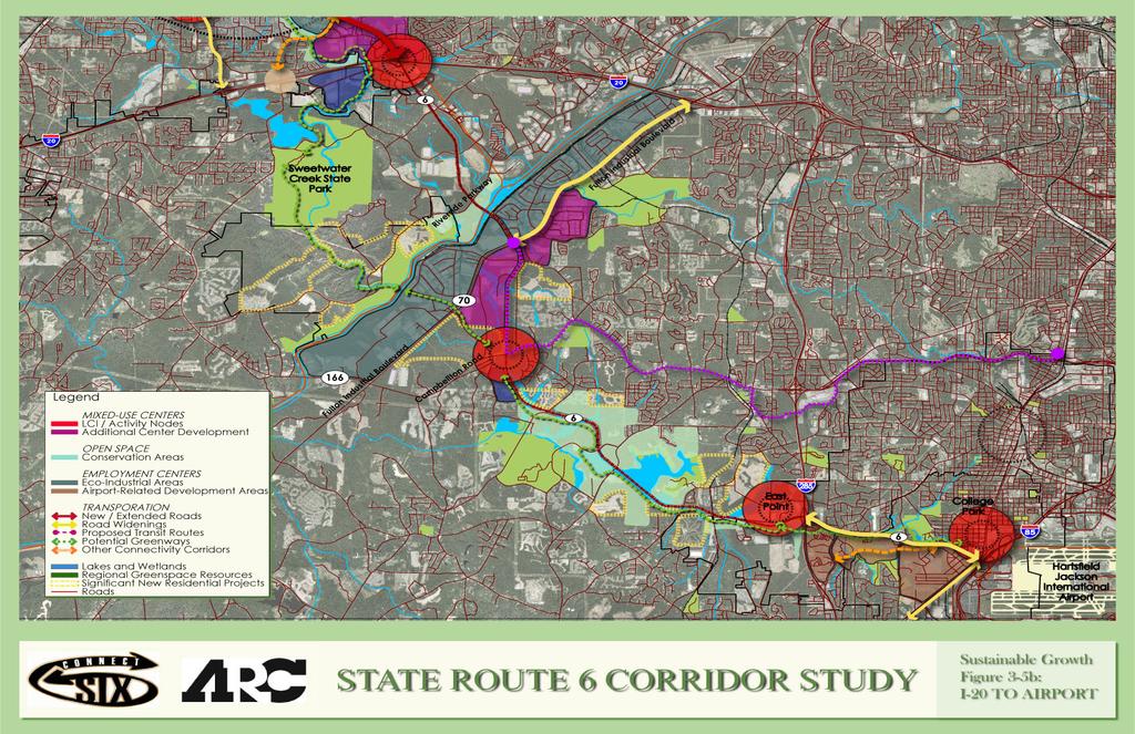
61
62 Industrial Park south of the Chattahoochee River is recommended along with the creation of a multijurisdictional alliance that would help guide development in the area to benefit all three counties: Fulton, Cobb, and Douglas. The area north of the river is developed into mixed use villages that take advantage of the natural settings and provide recreational opportunities. Open space conservation is prioritized and expanded around Wolf Creek Park to enhance community facilities in the area. Residential development in this area is required to use residential subdivision principles. High density commercial and office uses create nodes at I 285 and I 85 connected by mixed uses along the College Park portion of the corridor. Land uses leveraged by the airport constitute a large portion of recommendations for this area. Land use connectivity through the entire corridor is addressed through increased greenway, trail and street networks. Thus the sustainability growth framework layers the three broad land use categories over the basic future land use envisioned by county plans and regional policies, essentially a vision of urban and suburban residential neighborhoods decreasing in density from Atlanta s central core, with adjustments to reflect local priorities and conditions. The framework recognizes the place of the corridor in the future of the region, but gives equal weight to the growth issues that are most pressing to local communities Future Land Use Framework Land use along the SR 6 corridor varies to meet the existing environmental conditions as well as the vision and needs of the population present along it. In this process, care needs to be taken to develop the entire corridor and use its individual parts to make a single entity. The use of common land use policies ensures that new planning and development takes into consideration strategies that help protect and conserve the environment, create economic equity, and enable sound urban design practices like increased connectivity, density, provision for mixed use and infill development and water and wetland conservation. The strategies are intended to increase the quality of air and water and create a healthy environment that in turn provides people with a good quality of life. Some of the strategies that apply to the entire corridor are: Provide development strategies and infrastructure investments to accommodate forecast population and employment growth more efficiently. Final Report 3 37
63 Inform and involve the public in planning at regional, local and neighborhood levels. Coordinate local policies and regulations. Advance sustainable development that supports the protection, preservation and management of the natural environment. Diversify land uses along the corridor. Provide a variety of housing choices to ensure housing for individuals and families of diverse incomes and age groups. Diversify and increase the density of housing types to include multi family housing. Encourage the development of activity centers or nodes at major intersections. Reinforce existing town centers along the corridor. Promote industrial areas to be designed as eco industrial parks. Conserve open spaces and wetlands along the creeks. Provide additional local roadway network along SR 6 that is sensitive to natural resources. Provide a network of trails along the entire length of the corridor so as to connect the communities. As mentioned before, three basic land use types have been used along the corridor. Each of these uses some general guidelines which can be used for similar planning strategies anywhere in the corridor. Multijurisdictional alliance, mixed use nodes, ecoindustrial parks and conservation areas are discussed in further detail in the following sections. Create a multijurisdictional alliance for land use planning The land use strategy that has the most potential for advancing sustainability in the environmentally sensitive area around the Chattahoochee River as well as the corridor as a whole is the formation of a multijurisdictional planning alliance. This organization, discussed in Section 3.2.5, would be voluntary and ideally involving all entities affected by the future of SR 6. The initial objective of the alliance would be for outreach and education to convey and discuss issues surrounding growth in the corridor, along with fundraising for planning studies to address these emerging issues. If stakeholders and alliance leadership desired, powers such as self taxation, such as found in Community Improvement Districts (CIDs), and collective land use policy making could be added to the organization s mandate in the future. However, any land use policy proposals would be vetted through the local jurisdictional land use processes and would need to be approved by the land use making authority, whether a city or county. Final Report 3 38
64 Planning alliances are fairly common but usually rally around special interest topics like affordable housing, community participation or watershed ecology. Others focus on issues particular to a unique geographic area. In the Atlanta Region, the Tri County Alliance is a relevant example merging both approaches. A consortium of stakeholders from South Fulton, Coweta and Fayette Counties concerned specifically about traffic issues, the Tri County Alliance promotes inter governmental relations and initiates strategic and conceptual planning for transportation related projects. 7 A similar organization that deals primarily with land use and economic development is the Michigan Suburbs Alliance ( The geography encompassed by the Michigan Suburbs Alliance is economically declining, inner ring suburbs, while the program consists of forums for regional cooperation, policy initiatives, and redevelopment marketing. Both alliances exhibit organizational structures and agendas similar to one recommended for SR 6. Create mixed use nodes The concept of mixed use nodes revolves around concentrating commercial and housing activity in areas supported by suitable transportation infrastructure as well as diversifying land uses to reflect and respond to changing market conditions. This planning strategy is the foundation of the LCI program and is inspired by the land use patterns of traditional towns in the Region. The activity centers of SR 6, primarily the corridor s historic downtowns and existing LCI areas, contain the most intense development, while adjacent zones are usually less dense but are still well connected and programmatically diverse. Mixed use node development has many benefits. Proximity and diversity of land use results in decreased vehicular trips, which in turn decreases congestion, air and noise pollution and reduces the need for ownership of multiple vehicles. Concentrated populations make the provision of transit a realistic proposition, which in turn supports mobility equity. Higher density development lowers the cost per housing unit, potentially increasing affordability. Denser housing also increases local funds available to make infrastructure investments proportionate to the populations they serve. The list of nodal development s positive aspects is long and multifaceted: Creates economic strength through diverse uses and diverse markets; 7 The Citizen Online, Tri-County Alliance gets update on Hwy. 74, June 19, Final Report 3 39
65 Advances sustainable development through preservation and enhancement of the natural environment; Encourages efficient land use and balanced redevelopment; Preserves historic and cultural resources; Preserves and enhances existing residential neighborhoods; Supports investments in transportation infrastructure and community facilities within the area; Promotes the creation of public plazas and open spaces; Supports interconnectivity of trails and parks; Increases connectivity between adjacent parcels and secondary roadway systems, while decreasing the need for multiple vehicular trips by promoting alternatives to short distance trips though pedestrian and transit oriented developments; and Decreases the need for impervious surfaces. There are several places along the SR 6 corridor where new or expanded mixed use nodes are recommended. Many are strong candidates for further study under the LCI program, either as new LCI areas or as recipients of supplemental planning funds. At a minimum, the following areas should be targeted for priority LCI based planning: Historic center of Hiram, extending north to include the area surrounding the SR 6 and SR 92 intersection; West Powder Springs, including the areas around Florence, Elliott and Angham Roads and the Silver Comet Trail (see Figure 3 6); Historic Lithia Springs, including the US 78 corridor to SR 6; I 20 interchange area (see Figure 3 7); and Camp Creek Marketplace area (see Figure 3 8). Existing LCIs that could benefit from supplemental planning work in relation to SR 6 include Dallas, Austell, and Sandtown. Final Report 3 40
66 Develop eco industrial parks (EIPs) Conventional industrial uses along SR 6 have become increasingly more damaging to the environment as market situations have changed, not only from abandonment of older facilities in favor of new construction on greenfield sites, but also development of new facilities with extremely large impervious surfaces and high energy requirements. Eco industrial parks attempt to counter some of these negative side effects without overly inhibiting the economic benefits that make this land use attractive to local governments. The concept is fairly new, having grown along with the rise of the sustainability movement but built examples tend to be characterized by their differences instead of adhering to a prescribed set of rules. The most applicable set of best practices can be found in the Leadership in Energy and Environmental Design (LEED) standards for core and shell construction and for multiple building and campus construction. Typical LEED recommendations include: Redevelopment of brownfield or other deteriorated urban sites to reduce land conversion, maximize existing infrastructure and remove contamination threats in an economical way. Reduced site disturbance, minimizing damage to natural habitats that occur from temporary construction or building phasing activities, as well as minimizing the need for mass grading. Innovative stormwater management, controlling runoff and improving water quality by pervious pavement, rain gardens and decentralized bio pools. Reduced heat island, limiting the extent of heat reflective or conductive surfaces like pavement and certain roof membranes to lower the local ambient temperature, offsetting the need for air conditioning. Reduction of light pollution, using shielded exterior fixtures to concentrate light where it needs to be, to reduce wasteful over illumination and damage to nocturnal ecosystems. Reduction of energy use through advanced technology, including reduction in water demand for building uses or industrial processes, re use of water for irrigation and other nonessential purposes, highly efficient heating, ventilation, and air conditioning (HVAC) systems for power reduction, low thermaltransmission floor, wall and roof constructions, and others. Minimizing the waste stream, using recycled materials and renewable resources and managing construction waste to limit the amount of landfill. Final Report 3 41
67 Additional LEED information and sustainable development and construction standards can be found at the U. S. Green Building Council. 8 Beyond utilizing general green building practices, eco industrial parks can also employ techniques particular to their function that build on basic principles of sustainability. Several national EIPs show a wide range of responses to enhancing environmental and social responsibility while maximizing economic potential. Highlights include: Industry clustering business development and recruitment to concentrate most or all parts of a production chain within close proximity to reduce transportation costs and maximize intelligence exchange and innovation. Reprocessing or clean manufacturing structuring production systems in an EIP such that waste is used as another process input, minimizing the amount of raw materials and preliminary processing. Local energy generation using industrial buildings and processes to satisfy most or all EIP energy needs, such as solar panel arrays on large roof surfaces, or power generation from biomass or industrial by products. Vertical warehousing multi tiered storage that doubles as building structure and operates with automated retrieval systems, significantly reducing building footprint area without compromising storage capacity. Landfill reclamation locating manufacturing facilities on landfill sites to take advantage of both methane gas production and isolation of industrial hazards. Historically Underutilized Business (HUB) Zones intensifying existing underutilized small business districts through capital influx from federal contracts. EIPs can be as advanced as the level of commitment to sustainability, but the larger the investment in EIP concepts, the greater the level of coordination is required for success. For the study corridor, there are three ways of advancing EIPs at different scales. First, local land use regulations should be incrementally improved (with industrial or economic development agency collaboration) to include LEED and green building standards that target private sector industrial development, possibly along with incentives like energy or water purchase programs or performance based subsidies. Second, concentrations of industrial land uses that cross county borders should be organized under multijurisdictional industrial advocacy groups that can work for better coordination of government and resource use. Finally, sustainable industry should be monitored and promoted at a regional level, especially in conjunction with traffic congestion mitigation and water resource planning. 8 U. S. Green Building Council, Final Report 3 42
68 Identify and expand conservation areas The SR 6 corridor parallels Sweetwater Creek and Camp Creek for much of the corridor and is bisected by one of the state s most important water resources, the Chattahoochee River. The conservation area land use category responds directly to the wetlands, lakes and other watersheds that are impacted by SR 6. These environmentally sensitive lands are generally inappropriate for development due to wet soil, propensity to flood, and steep topography. Conservation areas also include agricultural land and important cultural landscapes. The intent of identifying and expanding conservation areas is to encourage landscape preservation and increase the inventory of natural open spaces along the corridor. This would benefit not only the many communities that live and work nearby, but would also create an opportunity for the greater community to have access to nature, especially rare environments like Sweetwater Creek and would prevent urban development from destroying all vacant land. Conservation areas also apply to residential developments that are suitable for conservation subdivision practices. This development approach is characterized by compact lots and common open spaces, where natural land features are protected and maintained to the greatest extent possible. The benefits of conservation subdivision practices are manifold and include the following: Creation of natural stormwater treatments. Protection of water quality through protection of the watershed. Flexibility of residential design to promote sustainability. Reduction of infrastructure requirements by permitting clustering, resulting in lower costs. Limited erosion and sedimentation through minimal land disturbance. Reduced demand for publicly funded green spaces. Creation of contiguous green spaces with adjacent jurisdictions with expanded greenway and trail systems. Conservation of scenic views. To allow for conservation areas to become an integral part of a community s future, it is necessary for them to be incorporated within local land use regulations and incentives. There are several ways this might be achieved, including impact fees and other revenues for direct acquisition, conservation easements, transfer of development rights (TDR), and others. For the SR 6 corridor, each tool could potentially play a role: Final Report 3 43
69 Direct acquisition Direct acquisition is the most predictable way to add to a jurisdiction s open space network, but it is potentially difficult because of competition for public funds. Possible funding mechanisms include greenspace bonds, impact fees on new development in an area in need of additional open space, or tax revenues from a SPLOST. Geographically specific sources could include tax allocation district (TAD) revenues or funds from future CIDs. Because of funding limitations, this strategy works best for expanding existing parks or providing new ones in areas with chronic need. In the SR 6 corridor, the likely areas include property around the Silver Comet Trail, Sweetwater Creek State Park, and Wolf Creek Park. Properties within existing TAD and LCI areas are also candidates for direct acquisition. Conservation easements This method relies on donations or purchases of land to preserve and protect some intrinsic quality such as scenic view, cultural resource, or habitat from future development. Since they are associated with landscape preservation and not necessarily usable open space, they would apply best to places in the SR 6 corridor that are in danger of disappearing, most notably rural environments that are still active or have their essential qualities intact. Such rural places can be found in isolated pockets in Paulding County, in West Cobb around Elliott Road and Brown Road, and in South Fulton along Campbellton Road and Butner Road. Transfer of development rights The nearby Chattahoochee Hill Country is an excellent model of a TDR program that could apply to portions of the corridor, although this strategy works best when there is both development pressure and significant natural resources or landscapes that are recognizably valuable. TDRs also require significant planning and organization, not the least because they depend on clearly defined sending and receiving areas, to work. The most promising locations in the study area for a TDR program are parts of South Fulton, primarily wetland areas along Camp Creek, which could be elements of a county effort to grow the Hill Country TDR. Another possible location might be Paulding County, given the growing pressure from residential development, the existing natural landscapes especially on the west, and the need for a comprehensive open space network. Other methods A well crafted conservation strategy includes multiple scales, from open space mandates as part of zoning and subdivision regulations, to partnerships with qualified land trusts or similar organizations for large dedications. Ideally, a multijurisdictional alliance, as described previously, could Final Report 3 44
70 take the lead on initiating and managing a comprehensive open space conservation plan Planning Subareas While the sustainability growth framework, as an approach for future land use along the corridor, assumes certain common policies and practices to be applied, certain subareas require a more focused, conceptual level treatment. Three mixed use nodes suitable for additional LCI type planning include: Powder Springs West, the I 20 Interchange and Camp Creek Marketplace. These areas are examined in more detail for opportunities to diversify uses, increase connectivity and preserve open space. The analysis and related development frameworks described below are intended only to illustrate issues and opportunities as well as provoke additional study; they are not conclusive or substitutes for more rigorous planning. Some of these areas, such as the I 20 Interchange, may require changes in the market as well as jurisdictional policy before supporting widespread mixed use development. Nevertheless, each area has traits that would support development intensification and coordination in the future. Similar approaches can address other areas along SR 6. Powder Springs West As illustrated in Figure 3 6, wetland conservation and economic development is encouraged for this area of Powder Springs by using infill development to meet the needs of an increasing population. The economic base for the city is enriched by concentrating industrial uses along SR 6 and commercial mixed uses around these industrial uses. The mixed use strategy capitalizes on the conservation of wetlands around Sweetwater Creek and its tributaries and on the presence of the greenway network created within the city to increase access to the Silver Comet Trail and provide a connection to the Sweetwater Creek State Park. The mixed use developments are fairly intense commercial office with complementary retail and residential uses that capture the market created by the greenway amenities. The strategy of higher density nodal development is used to anchor the intersections of important roads and take advantage of the traffic flow. The key element in this development strategy is increasing connectivity between land uses and parcels to decrease local traffic on SR 6, provide alternative means to reach destinations in and around the city, and encourage a pedestrian friendly environment. Two primary connectivity enhancements are the realignment and connection of the Hiram Lithia Springs Road to the Old Dallas Highway and the extension of Florence Road south to Final Report 3 45
71 Brooks Ln SW Legend: Land Use Land Use - Powder Springs West: Residential Commercial Mixed-Use Office Industrial Lakes and Wetlands Conservation Areas / Open Space Greenways / Trails State Route 6 Roads Changed in Alignment or Length Connectivity Enhancements Increased local street network for a pedestrian friendly environment Greater access to the Silver Comet Trail Industrial along SR6 Fairly intense office with complimentary retail and residential to capture market attracted by greenway amenities Higher density nodal development REYNOLDS RD CLEBURNE PKWY ROSEDALE DR ANGHAM RD Paulding County FOXBORO DR BENSINGER CT PIERCE RD LEE ANNA PATH Powder Springs Dallas Rd Hiram Lithia Springs Rd Morris Rd SW Story Rd SW Elliott Rd SW Angham Rd SW Hiram Lithia Springs Rd Quarters Ln SW Elliott Rd C H James Pky Story Rd Springtide Ln SW Finch Rd Finch Rd Saint George Ter SW Paddocks Way Elliott Rd SW Kilpatrick Rd SW Fambrough Dr SW Lawler Dr SW Old Dallas Hwy SW Pine Way Rd SW Ray Ct SW Glendora Dr SW Hopeland Dr St Claire Pl Florence Rd SW Beaumont Wood Shipp Rd Richard D Sailors Pky Hill Rd SW Hickory Ln SW Dallas Hwy SW Brownsville Rd Moon Rd SW Cobb County Shipp Rd Lochness Ln SW Hobbit Glen SW Hunter Rd SW Wylie Ln SW Old Lost Mountain Rd SW Dallas Hwy SW Meek Rd SW Carlos Ct SW Steading Rd SW Macedonia Rd SW Cathey Cir SW Lynn Dr SW Old Lost Mountain Rd SW Jackson Way Thomas St SW Long St Barrett Ct Jones Ct SW Sutton Ct SW Commodore Rd SW Pinetree Ct SW Pineview Dr SW Atlanta St SW Heath Ct SW Springdale Cir SW Pinetree Dr SW Dillard St Dillard St SW New Macland Rd New Macland Rd SW New Macland Rd Compton Cir SW Marietta St SW Atlanta St Braemore Pl SW STATE ROUTE 6 CORRIDOR STUDY Figure 3-6: Powder Springs West
72 Hill Road. Other enhancements include creating backage roads on either side of SR 6 and increasing connections between the existing local street networks. I 20 Interchange Development recommendations for I 20 are illustrated in Figure 3 7, a mixed use node taking a cue from the proximity to I 20. A solid economic base is created for Douglas and Cobb Counties by the combination of industrial and intense commercial mixeduses. Industrial development is concentrated around Westfork Drive and Maxham Road to benefit Douglas County and in the southeast corner of the I 20 interchange to benefit Cobb County. A trail along Sweetwater Creek connects the Silver Comet Trail to the Sweetwater Creek State Park through Powder Springs. An additional greenway bisecting the area improves access for the residential uses along Blair Bridge Road. Low to medium density mixed uses, consisting of residential, office and retail developments, take advantage of the greenways as development drivers and are oriented to them to capture the high market and residential value created by these amenities. Higher density, more intense office and retail development dominates the intersections of high volume roadways, creating smaller nodes where concentrated activities result in multiple focal points. The development program is strengthened by increasing the local street network to promote pedestrian activity and mobility alternatives. A connection of Maxham Road to Skyview Drive and on to Mount Vernon offers an alternate means for industrial traffic to move from the Norfolk Southern Whitaker Intermodal Terminal to I 20. Existing local streets might be improved through the creation of additional local streets or through extension. Camp Creek East Development in Camp Creek East is generally more intense compared to the rest of the SR 6 corridor, as illustrated in Figure 3 8. The future land use framework builds upon the existing assets of the area such as HJAIA, Camp Creek Marketplace, and access to the interstate highways. Conservation of the Camp Creek environment and creation of the a Camp Creek greenway connecting the Chattahoochee River to the creek headwaters in the vicinity of downtown College Park provides a valuable open space resource to the adjoining communities and the logic for a parkway system, expanding the positive influence of the historic country club. Land use closer to HJAIA maximizes the market potential for hospitality, commercial, and convention uses leveraged by the airport. The Georgia International Convention Center and the (CONRAC) facility with Final Report 3 47
73 Bridgeport Ct William Rd Legend: Land Use Residential Commercial Mixed-Use Office Industrial Lakes and Wetlands Conservation Areas / Open Space Greenways / Trails State Route 6 Roads Changed in Alignment or Length Connectivity Enhancements Land Use - I-20 Interchange: Industrial around Westfork and south of I-20 in Cobb County Intense office and retail development around the I-20 interchange Low to medium density mixed-use consisting of residential, office and retail oriented to wards the creek Sweetwater Creek as a development driver and amenity Greenway connection to Sweetwater Creek State Park and to the Silver Comet Trail Brannon Dr Marian Ct Mt Vernon Rd I-20 Mt Vernon Rd Monier Ave Mount Vernon Rd Mount Vernon Rd Jenny Ln Mount Vernon Rd Crossing Dr Romans Rd Whiteflag Trl Fawn Ln 20 Brumby Cir Aspen Dr Silver Way Silver Creek Dr Silverdale Ln Thornton Rd Campbell Ct Sydney Ct Westfork Blvd Skyview Dr E Thornton Rd Westfork Dr Douglas County Maxham Rd Maxham Rd Tom Murray Fwy Skyview Dr Blairs Bridge Rd Coventry Pt SW Waterford Club Dr Thornton Way Crestmark Dr Cobb County Oak Ridge Pkwy SW I-20 Ramp Bob Arnold Dr Trae Ln Ivy Pointe Row N Blairs Bridge Rd Malvin Dr SW Oak Ridge Rd SW W Pointe Ct Blair Bridge Rd SW Linda Ln S Dillon Rd SW Panda Dr I-20 Thornton Rd Interstate West Pky Cardinal Ln SW Ivy Log Dr SW Ling Way SW Six Flags Rd Ling Dr Devon Mill Way SW Lake Xing Factory Shoals Rd Laura Ln Six Flags Dr Ling Dr SW Grinder Dr SW I-20 Revena Ln Silverton Trl SW First Flags Dr Revena Dr Flamingo Dr S Gordon Rd SW Hembree Dr White Rd Factory Shoals Rd SW Second Flags Dr Pleasant Dr Sibyl Dr SW Flamingo Dr SW Winterbrook Way 20 Wade Rd STATE ROUTE 6 CORRIDOR STUDY Figure 3-7: I-20 Interchange

74 I-285 I-285 Exwy Calmer Cir Leigh Cir Legend: Land Use Residential Commercial Mixed-Use Office Airport Hospitality / Commercial / Convention CONRAC Lakes and Wetlands Conservation Areas / Open Space Greenways / Trails State Route 6 Roads Changed in Alignment or Length Connectivity Enhancements Automated People Mover Land Use - Camp Creek East: Intense office and commercial development leveraged by the airport High density mixed-use south of SR6; redevelopment of existing multi-family residential Higher density nodes of I-285 and I-85 connected by lower density development Creation of a greenway along Camp Creek Redevelopment of parking facilities north of SR6 Fulton County 285 Redwine Rd I-285 Ramp I-285 I-285 Ramp N Desert Dr Desert Cir Scott Cir S Desert Dr Washington Rd I-285 Sir Henry St Duke Of Gloucester St Ale Cir Young Dr Hammarskjold Ave Fox Hunt Ln SW Spanish Trl SW Chestnut Dr I-285 Ramp I Sun Valley Blvd Pelot Dr Janice Dr Palm Springs Dr Redwine Ct W Potomac Dr Victoria Dr Yates Rd Lakemont Dr Arlington Rd Karen Rd Scenic Dr Lucile Ln Duke Of Windsor St Scenic Ter Potomac Dr Potomac Ter Charlestown Dr York Rd Charles Dr Frontage Rd Glenda Dr Mt Olive Rd Dresden Trl Colonial Dr Lakeshore Dr Dodson Dr Colonial Dr Rugby Ave Carol Ct Dodson Ter Carriage Way Herschel Rd Stone Rd Camp Creek Pky Williamsburg Dr Ross Dr Skyline Dr Arundel Rd Brandon Rd Dodson Dr Conn Spring Rd Fairway Dr Golfview Dr Riverdale Rd Heaton Dr Parkview Dr Flowers Dr Rugby Ln Abbott St Horton Dr W Point Ave Lyle Rd Rugby Ter Perkins Dr Harris Dr Redwine Ave Rhodes St Almand Dr Roosevelt Hwy Pierce St Roosevelt St English Ln Cambridge Ave N Atlanta St Princeton Dr Princeton Ave Mercer Ave Walker Ave I-85 N Victoria St N College St Harvard Ave Columbia Ave N Terminal Pky N Atlanta St Rugby Ave John Wesley Ave Napoleon St Oxford Ave S Conley St W Point Ave Lyle Ave Hemphill St John Calvin Ave Autoport Dr Yale Ave Oxford Ave Airport Blvd I-85 Main St Main St Airport Cir I-85 STATE ROUTE 6 CORRIDOR STUDY Figure 3-8: Camp Creek East
Point A Point B Point C Point D. City of Hapeville Public Meeting July 25, 2017
 City of Hapeville Public Meeting July 25, 2017 Fulton County Transit Master Plan Overview Following last year s ¾-cent TSPLOST effort, the Mayors of the 14 Cities outside of Atlanta and the Fulton County
12/9/2013. HOLLYWOOD/PINES CORRIDOR PROJECT AMPO 2013 Annual Conference October 24, Our Perspective. Broward.
 HOLLYWOOD/PINES CORRIDOR PROJECT AMPO 2013 Annual Conference October 24, 2013 Our Perspective Broward Fort Lauderdale 1 Broward Metropolitan Planning Organization Fort Lauderdale Fort Lauderdale Skyline
Gold Line Bus Rapid Transit Transit Oriented Development (BRTOD) Helmo Station Area Plan
 Helmo Station Area Plan") Appendix F Gold Line Bus Rapid Transit Transit Oriented Development (BRTOD) Helmo Station Area Plan Introduction and Purpose of the Plan The Gold Line Bus Rapid Transit facility is an eleven-mile dedicated
Appendix F Gold Line Bus Rapid Transit Transit Oriented Development (BRTOD) Helmo Station Area Plan Introduction and Purpose of the Plan The Gold Line Bus Rapid Transit facility is an eleven-mile dedicated
South Davis County COMMUNITY SPOTLIGHT
 South Davis County COMMUNITY SPOTLIGHT Davis/SLC Community Connector Bus Rapid Transit line connecting SLC & Davis County RTP Phase 1 Project Generate 3,100 average weekday riders Relieve congestion on
BeltLine Corridor Environmental Study
 BeltLine Corridor Environmental Study Citywide Conversation on Transit and Trails April 2, 2009 Agenda & Introductions Introductions Environmental Study Process Overview of the BeltLine Project BeltLine
CHAPTER 7: Transportation, Mobility and Circulation
 AGLE AREA COMMUNITY Plan CHAPTER 7 CHAPTER 7: Transportation, Mobility and Circulation Transportation, Mobility and Circulation The purpose of the Transportation, Mobility and Circulation Chapter is to
Chapter 1.0 Introduction
 Chapter 1.0 Introduction 1.1 Background The North Metro commuter rail line is part of the RTD FasTracks regional transit system expansion program to build more than 100 miles of rail transit throughout
Transportation. Strategies for Action
 Transportation A major priority for the Overlake Neighborhood is to develop a multimodal transportation system. To achieve this system, a balance has to be found among travel, circulation and access needs;
Route 1 Corridor Study
 Route 1 Corridor Study Westbrook, Connecticut A Vision for the Connecticut Shoreline Public Informational Meeting July 28, 2015 Lower Connecticut River Valley Council of Governments Fitzgerald & Halliday,
Executive Summary. NY 7 / NY 2 Corridor
 Executive Summary NY 7 / NY 2 Corridor Transportation and Land Use Study December 2005 Prepared for: Town of Colonie Capital District Transportation Committee Prepared by: Introduction: Land use decisions
Introduction. Chapter 1. Purpose of the Comprehensive Plan Plan Organization Planning Process & Community Input 1-1
 Chapter 1 Introduction Lakewood 2025: Moving Forward Together Purpose of the Comprehensive Plan Plan Organization Planning Process & Community Input 1-1 Purpose of the Comprehensive Plan The Comprehensive
EXISTING COMPREHENSIVE PLAN
 EXISTING COMPREHENSIVE PLAN Town Center Land Use Element: V. LAND USE POLICIES Town Center Mercer Island's business district vision as described in "Your Mercer Island Citizen-Designed Downtown" was an
Secrest Short Cut and Monroe Expressway Small Area Plan AUGUST 29, 2018
 Secrest Short Cut and Monroe Expressway Small Area Plan AUGUST 29, 2018 Background and Process Monroe Expressway will be open by the end of 2018 Union County and Indian Trail identified a need to revisit
Scope of Services. River Oaks Boulevard (SH 183) Corridor Master Plan
 Corridor Master Plan") Scope of Services River Oaks Boulevard (SH 183) Corridor Master Plan PROJECT AREA The project area consists of the River Oaks Boulevard (SH 183) corridor bounded by SH 199 at the northern end and the Trinity
Scope of Services River Oaks Boulevard (SH 183) Corridor Master Plan PROJECT AREA The project area consists of the River Oaks Boulevard (SH 183) corridor bounded by SH 199 at the northern end and the Trinity
Chapter 1: Introduction
 Chapter 1: Introduction The Penn Avenue Community Works Corridor Vision and Implementation Framework presents an integrated communitybased vision and a coordinated, long-term implementation framework for
master plan of highways bus rapid transit amendment
 Scope of Work master plan of highways bus rapid transit amendment September 2011 Montgomery County Planning Department M-NCPPC MontgomeryPlanning.org 1 Scope of Work master plan of highways bus rapid transit
PSRC REVIEW REPORT & CERTIFICATION RECOMMENDATION
 PSRC REVIEW REPORT & CERTIFICATION RECOMMENDATION KITSAP COUNTY COUNTYWIDE PLANNING POLICIES July 2, 2012 BACKGROUND A major emphasis of the Washington State Growth Management Act (GMA) is the need to
Urban Planning and Land Use
 Urban Planning and Land Use 701 North 7 th Street, Room 423 Phone: (913) 573-5750 Kansas City, Kansas 66101 Fax: (913) 573-5796 Email: planninginfo@wycokck.org www.wycokck.org/planning To: From: City Planning
Atlanta BeltLine Corridor Environmental Study. Scoping Meeting August 2008
 Atlanta BeltLine Corridor Environmental Study Scoping Meeting August 2008 What Will We Be Discussing Today? Study Overview - How Did We Get Here? - What Is the Study About? - Who Is Involved? - Where Is
BeltLine Corridor Environmental Study
 BeltLine Corridor Environmental Study Joint TAC and SAC Meeting December 8, 2008 What We Will Discuss Today Outreach and Agency Coordination Scoping Results Existing Conditions Historical and Archeological
The transportation system in a community is an
 7 TRANSPORTATION The transportation system in a community is an important factor contributing to the quality of life of the residents. Without a sound transportation system to bring both goods and patrons
Town Center (part of the Comprehensive Plan)
") Town Center (part of the Comprehensive Plan) Mercer Island Town Center Looking North (2014) In 1994, a year-long process culminated in a set of design guidelines and code requirements for the Town Center
Town Center (part of the Comprehensive Plan) Mercer Island Town Center Looking North (2014) In 1994, a year-long process culminated in a set of design guidelines and code requirements for the Town Center
TRANSPORTATION ELEMENT GOALS, OBJECTIVES, AND POLICIES
 TRANSPORTATION ELEMENT GOALS, OBJECTIVES, AND POLICIES GOAL 2 The City shall provide a safe, convenient, effective, and energy efficient multimodal transportation system which is coordinated with the Future
S C O P E O F W O R K A P R I L
 white flint 2 sector plan S C O P E O F W O R K A P R I L 2 0 1 2 MONTGOMERY COUNTY PLANNING DEPARTMENT M-NCPPC MontgomeryPlanning.org 1 white flint 2 sector plan Scope of Work abstract This scope of work
SH 199 Corridor Master Plan. Community Meeting No. 2 May 31, 2017
 Community Meeting No. 2 May 31, 2017 Transportation Projects On or Near SH 199 SH 199 from 0.3 miles south of FM 1886 to south end of Lake Worth bridge Construct freeway mainlanes and frontage roads 10-Year
CHAPTER 1. Ms. Guajardo s Class - Central Elementary CH 1 1
 INTRODUCTION CHAPTER 1 Ms. Guajardo s Class - Central Elementary CH 1 1 1.1 SETTING South Centre City is a linear corridor south of Downtown Escondido paralleling Centre City Parkway and South Escondido
Harlem Avenue Corridor Plan: Corridor Planning Across Municipal Boundaries
 Harlem Avenue Corridor Plan: Corridor Planning Across Municipal Boundaries Heather Tabbert, Manager, Local Planning and Programs Division Regional Transportation Authority (RTA) Jen McNeil Dhadwal, Principal
Mississippi Skyway Preliminary Engineering Report
 EXECUTIVE SUMMARY Mississippi Skyway Preliminary Engineering Report CITY OF RAMSEY, MINNESOTA DECEMBER 2014 City of RAMSEY EXECUTIVE SUMMARY Project Need and Intent The Mississippi Skyway pedestrian bridge
Small Area Plan. South Gateway
 Small Area Plan Adopted May 12, 2008 South Gateway Purpose. The South Gateway Small Area Plan defines the City s expectations for the future of the southern entrance to the City at Interstate 85 and Highway
South Fulton Parkway Transit Feasibility Study
 South Fulton Parkway Transit Feasibility Study Study Purpose To conduct a high level assessment of potential transit improvements in the South Fulton Parkway Corridor through the evaluation of various
Sacramento Area Council of Governments (SACOG)
") Sacramento Area Council of Governments (SACOG) The Blueprint Vision The SACOG Board of Directors adopted the Preferred Blueprint Scenario in December 2004, a bold vision for growth that promotes compact,
Sacramento Area Council of Governments (SACOG) The Blueprint Vision The SACOG Board of Directors adopted the Preferred Blueprint Scenario in December 2004, a bold vision for growth that promotes compact,
EXECUTIVE SUMMARY DRAFT CHAPTER 1 INTRODUCTION EXECUTIVE SUMMARY
 CHAPTER 1 EXECUTIVE SUMMARY INTRODUCTION Through the joint efforts of the City of Tulsa planning staff and the Land Services division of Indian Nations Council of Governments (INCOG), the Berryhill Land
Atlanta BeltLine Subarea 3 Master Plan Update
 Atlanta BeltLine Subarea 3 Master Plan Update April 14, 2018 Workshop Meeting 1 22 miles, connecting 45 neighborhoods 22 MILES of transit 46 MILES of streetscapes and complete streets 33 MILES of urban
1.0 Introduction. Purpose and Basis for Updating the TMP. Introduction 1
 1.0 Introduction The Town of Castle Rock is situated between the metropolitan areas of Denver and Colorado Springs, amidst a unique terrain of rolling hills, mesas, ravines, and waterways. Like many Front
Public input has been an important part of the plan development process.
 Lakewood s Comprehensive Plan recognizes that transportation helps shape the community, and that the way the community provides for the safe and efficient movement of people affects the character of the
Cobb County Design Guidelines Mableton Parkway & Veterans Memorial Highway Community Design Workshop January 12, 2017
 Community Design Workshop January 12, 2017 Agenda Opening Remarks / Introductions Scope of Work Existing Conditions Key Issues / Opportunities VPS Summary Draft Vision & Goal Statement Implementation Concepts
FUTURE LAND USE ELEMENT
 FUTURE LAND USE ELEMENT GOAL I: To create and sustain a great place to live, play, and prosper Objective 1: The City of Ocala shall incorporate the principles and strategies of the Ocala 2035 Vision into
DRAFT PLAN PRESENTATION
 DRAFT PLAN PRESENTATION 1.23.2018 AGENDA Process Project Schedule Results from Visioning Workshop Draft Plan Highlights Concept Plans Feedback Next Steps PROJECT SCHEDULE KICK-OFF WORKSHOP August 29 th
Corridor Vision. 1Pursue Minnehaha-Hiawatha Community Works Project. Mission of Hennepin County Community Works Program
 1Pursue Minnehaha-Hiawatha Community Works Project Minnehaha-Hiawatha Community Works is a project within the Hennepin Community Works (HCW) program. The mission of the HCW program is to enhance how the
Plano Tomorrow Vision and Policies
 Plano Tomorrow Vision and Policies PLANO TOMORROW PILLARS The Built Environment The Social Environment The Natural Environment The Economic Environment Land Use and Urban Design Transportation Housing
2.0 PURPOSE AND NEED. 2.1 Purpose. 2.2 Need Traffic Congestion in and around Downtown Derry
 2.0 PURPOSE AND NEED Taking into consideration agency and public input, the purpose and need for the Project was identified early in Project planning. As noted in Appendix A, for purposes of meeting the
1.0 INTRODUCTION 1.1 TH 14 WEST STUDY AREA Project Description Functional Classification Purpose of the Project
 1.0 INTRODUCTION 1.1 TH 14 WEST STUDY AREA 1.1.1 Project Description The Trunk Highway (TH) 14 West Corridor is a two-lane roadway approximately 22 miles in length. Located in Nicollet County, the corridor
ARLINGTON COUNTY, VIRGINIA
 ARLINGTON COUNTY, VIRGINIA County Board Agenda Item Meeting October 15, 2005 DATE: September 28, 2005 SUBJECT: Request to Advertise the adoption of the 2005 Clarendon Sector Plan C. M. RECOMMENDATION:
Implementation Guide Comprehensive Plan City of Allen
 Implementation Guide 2030 Comprehensive Plan City of Allen DRAFT 2015 Implementation Guide Allen 2030 Comprehensive Plan INTRODUCTION The Comprehensive Plan serves as a guide for the growth and development
Issues Requiring Future Study
 Issues Requiring Future Study Transportation planning is an ongoing process that tends to identify new issues as it finds solutions for others. Some issues are so complex that a solution to one problem
A. WHAT IS A GENERAL PLAN?
 I. Introduction A. WHAT IS A GENERAL PLAN? A general plan is the planning guideline for the future of a city. It contains goals and policies which regulate urban development, the protection of the natural
FUNDING CORRIDOR REVITALIZATION
 FUNDING CORRIDOR REVITALIZATION Integrated corridor planning for the 21 st Century America Planning Association Annual Conference Atlanta, GA April 27, 2014 Mariia Zimmerman, MZ Strategies, LLC mariia@mzstrategies.com
INDEPENDENCE BOULEVARD AREA PLAN. June 24, 2008
 INDEPENDENCE BOULEVARD AREA PLAN Public Meeting #1 June 24, 2008 Tonight s Agenda Introduction Welcome and Ground Rules Overview Presentation Purpose of the Plan What Brings Us Here? A Tour of the Corridor
SAN RAFAEL GENERAL PLAN 2040 INTRODUCTION AND OVERVIEW
 SAN RAFAEL GENERAL PLAN 2040 INTRODUCTION AND OVERVIEW Steering Committee Presentation February 14, 2018 Purpose of General Plan Guide land use and development decisions Coordinate transportation, infrastructure,
RESOLUTION NO. R Refining the route, profile and stations for the Downtown Redmond Link Extension
 RESOLUTION NO. R2018-32 Refining the route, profile and stations for the Downtown Redmond Link Extension MEETING: DATE: TYPE OF ACTION: STAFF CONTACT: Capital Committee Board PROPOSED ACTION 09/13/2018
City of Farmington. Downtown Plan. Amendment to the 1998 Master Plan Adopted October 11, 2004
 City of Farmington Amendment to the 1998 Master Plan Adopted October 11, 2004 Introduction Planning Background 1 Scope and Components of the Plan Amendment 2 Concept Introduction 3 Plan Concepts 3 Conceptual
IMPLEMENTATION STRATEGIES. In This Chapter. Goals & Strategies 182 Project List 183 Future Land Use 186 CHAPTER 11 IMPLEMENTATION STRATEGIES
 In This Chapter Goals & Strategies 182 Project List 183 Future Land Use 186 11 IMPLEMENTATION STRATEGIES NORTH AUGUSTA, SC 2017 COMPREHENSIVE PLAN 179 Individual commitment to a group effort that is what
DRAFT Subject to Modifications
 TREASURE COAST REGIONAL PLANNING COUNCIL M E M O R A N D U M To: Council Members AGENDA ITEM 8 From: Date: Subject: Staff May 19, 2017 Council Meeting Florida Department of Transportation Complete Streets
Volume 2: Implementation Plan
 Volume 2: Implementation Plan February 25 th 2002 Implementation Introduction This document outlines the steps that should be taken to implement the Washington Heights Neighborhood Plan. The City Council
I. INTRODUCTION. Project Background and Study Area
 I. INTRODUCTION Project Background and Study Area Freedom Parkway is a key east-west corridor connecting I-25 on the west to the Town of Kersey on the east, running approximately one to two miles south
Land Use Amendment in Southwood (Ward 11) at and Elbow Drive SW, LOC
 at and Elbow Drive SW, LOC") 2018 November 15 Page 1 of 10 EXECUTIVE SUMMARY This land use amendment application was submitted by Rick Balbi Architect on 2017 August 31 on behalf of Sable Developments Ltd, and with authorization from
2018 November 15 Page 1 of 10 EXECUTIVE SUMMARY This land use amendment application was submitted by Rick Balbi Architect on 2017 August 31 on behalf of Sable Developments Ltd, and with authorization from
Preliminary Plan Framework: Vision and Goals
 Preliminary Plan Framework: Vision and Goals Draft: May 2015 Introduction Since the Town of Milliken s comprehensive plan was last updated in 2010, the community was heavily impacted by the 2013 flood,
Realities and Assets in an In-Town Shopping Center
 SUSTAIN SOUTHERN MAINE MILL CREEK PILOT LESSONS LEARNED April 15, 2013 Realities and Assets in an In-Town Shopping Center 1. An older shopping district that was laid out in a low-density, strip center
Table of Contents. Elm Avenue Improvement Plan City of Waco, Texas. Introduction 1. Existing Context 1 Figure 1 2.
 Table of Contents Introduction 1 Existing Context 1 Figure 1 2 Plan Guidelines 3 Future Urban Form 4 The West-End 4 Main Street 6 The East-End 7 Figure 2 9 Public Improvement Recommendations 7 General
3. Endorse the LRT vision in transforming Surrey into Connected-Complete-Livable communities, and more specifically, the official vision statement:
 CORPORATE REPORT NO: R038 COUNCIL DATE: February 20, 2017 REGULAR COUNCIL TO: Mayor & Council DATE: February 16, 2017 FROM: General Manager, Engineering FILE: 8740-01 SUBJECT: Surrey Light Rail Transit
Lesson 6. Corridor Planning
 Lesson 6 Corridor Planning 1 Learning Outcomes Identify land use strategies and solutions that can be incorporated into multimodal transportation corridor plans Identify land use stakeholders and describe
Southern Gateway Project and Public Green
 Southern Gateway Project and Public Green Transportation and Trinity River Project Committee May 23, 2016 Purpose of Presentation Provide the history and an overview of the Southern Gateway Project (SGP)
Atlanta BeltLine. Subareas 9 & 10. Master Plan Updates. March 26, Washington Park Jamboree 1
 Atlanta BeltLine Subareas 9 & 10 Master Plan Updates March 26, 2018 Washington Park Jamboree 1 22 miles, connecting 45 neighborhoods 22 MILES of transit 46 MILES of streetscapes and complete streets 33
Sheridan Boulevard S TAT I O N A R E A P L A N S H E R I D A N B O U L E VA R D S TAT I O N A R E A P L A N
 Sheridan Boulevard S TAT I O N A R E A P L A N 1 City of Lakewood Adopted November, 2006 S H E R I D A N B O U L E VA R D S TAT I O N A R E A P L A N The Vision The City of Lakewood s overall vision is
CITY CLERK. Parkland Acquisition Strategic Directions Report (All Wards)
") CITY CLERK Clause embodied in Report No. 10 of the, as adopted by the Council of the City of Toronto at its meeting held on November 6, 7 and 8, 2001. 10 Parkland Acquisition Strategic Directions Report
CITY CLERK Clause embodied in Report No. 10 of the, as adopted by the Council of the City of Toronto at its meeting held on November 6, 7 and 8, 2001. 10 Parkland Acquisition Strategic Directions Report
Midtown Greenway Land Use and Development Plan Executive Summary
 Midtown Greenway Land Use and Development Plan Executive Summary Introduction The Midtown Greenway Land Use and Development Plan sets policy direction for land use and development in the Midtown Greenway
Port Lavaca Future Land Use
 Port Lavaca Future Land Use Introduction The City of Port Lavaca is beginning to see sustained growth, after many years of relative stable population. New single family homes, apartments, and businesses
TOWN COUNCIL / PLANNING COMMISSION
 Workshop #3 TOWN COUNCIL / PLANNING COMMISSION January 20, 2011 Consultant Team In Attendance Tonight BMS Design Group Nevada City and San Francisco Michael Smiley, AICP, ASLA Partner-in-Charge Nancy L.
Rio/29 Small Area Plan. Design Plan & Implementation Framework Open House - January 25, 2018
 Rio/29 Small Area Plan Design Plan & Implementation Framework Open House - January 25, 2018 MEETING PURPOSE PRESENTATION 1. Orient to the updated design plans 2. Introduce implementing options 3. Explain
MORRISVILLE TRANSPORTATION PLAN TOWN COUNCIL PRESENTATION AUGUST 22, 2017
 TOWN COUNCIL PRESENTATION AUGUST 22, 2017 SCENARIO PLANNING CORRIDORS Town Hall Drive Baseline + 2 McCrimmon Parkway Baseline + 2 NC 54 Baseline + 2 7 subregion model runs determining carrying capacity
PART 1. Background to the Study. Avenue Study. The Danforth
 The Danforth 1.1/ Study Purpose & Key Municipal Goals 1.2/ The Local Advisory Committee 1.3/ The Project Team 1.4/ Study Process/Summary of Method 1.5/ Summary of Consultation 1.1 Study Purpose and Key
Gary & Regional Investment Project. October 27, Creating Tomorrow Today Comprehensive Regional Plan - NIRPC
 Creating Tomorrow Today 2040 Comprehensive Regional Plan Gary & Regional Investment Project October 27, 2010 Creating Tomorrow Today - 2040 Comprehensive Regional Plan - NIRPC What is NIRPC? - Northwestern
ELK GROVE GENERAL PLAN VISION
 2-1 CHAPTER 2: 2-2 CREATING OUR The Community Vision for Elk Grove, expressed through a Vision Statement and a series of Supporting Principles, is a declaration of the kind of community that Elk Grove
Date: April 10, 2017 City Council Work Session April 24, 2017: Status Report on the Comprehensive Plan Update and Transportation Master Plan
 AGENDA REPORT To: From: By: Honorable Mayor and City Council Members Warren Hutmacher, City Manager Sharon Ebert, Director Community Development Date: April 10, 2017 Agenda: City Council Work Session April
greenprint midtown SUSTAINABILITY ACTION PLAN 2012
 greenprint midtown SUSTAINABILITY ACTION PLAN 2012 MIDTOWN ALLIANCE SOUTHFACE ENERGY INSTITUTE RENAISSANCE PLANNING GROUP SUSTAINABLE ATLANTA PERKINS+WILL 2 GREENPRINT MIDTOWN 1. Introduction Sustainability
CITY COUNCIL AGENDA REPORT
 CITY COUNCIL AGENDA REPORT Subject: COUNCIL MOTION LRT ALIGNMENT REMOVAL FROM THE TRANSPORTATION MASTER PLAN On February 10, 2016 Councillor Hughes provided notice in accordance with Section 23 of Procedure
Windsor Locks Transit-Oriented Development Planning Grant Request. Project Background
 Windsor Locks Transit-Oriented Development Planning Grant Request Project Background Downtown Windsor Locks runs along Main Street in the vicinity of the intersection of Routes 159 and 140. The current
Transit / Housing Oriented Redevelopment
 Broward County Urban Planning and Redevelopment Department Kick-Off Meeting October 24, 2007 Transit / Housing Oriented Redevelopment 1 Future Land Use 2 Broward County Charter Voters approved in 1974.
Chapter 4. Linking Land Use with Transportation. Chapter 4
 Chapter 4 Linking Land Use with Transportation Chapter 4 59 Chapter 4 Linking Land Use with Transportation Community Design and Transportation Program Introduction Since the 1950s, the predominant development
Comprehensive Development Guide
 INDUSTRIAL ELEMENT Comprehensive Development Guide 1 Industrial Element 7.1 Hardin County Industrial Overview BG PKWY Fort Knox Industrial Corridor Comprised of 11 parcels totaling 720 acres of land 68
CITY OF COLWICH COMPREHENSIVE PLAN LAND USE LAND USE 1
 LAND USE LAND USE 1 WHAT YOU WILL FIND IN THIS CHAPTER: Discussion of today s conditions and tomorrow s projections Discussion of challenges and opportunities Discussion of the environmental quality goals,
4-Town Comprehensive Plan DRAFT 7/30/07
 4-Town Comprehensive Plan DRAFT 7/30/07 Acknowledgements ning Committee Town of Harrisburg Norman Roof Randy Nicol Town of Martinsburg Terry Thisse Paul Kelly Town of Montague Jan Bagdanowicz Wendy Perry
North Fair Oaks Community Plan Summary and Information
 North Fair Oaks Community Plan Summary and Information WHAT IS THE NORTH FAIR OAKS COMMUNITY PLAN? The North Fair Oaks Community Plan is part of the San Mateo County General Plan, and establishes policies
Eastern Terminus TECHNICAL MEMORANDUM CENTRAL BROWARD EAST-WEST TRANSIT ANALYSIS BROWARD COUNTY, FLORIDA
 Eastern Terminus TECHNICAL MEMORANDUM CENTRAL BROWARD EAST-WEST TRANSIT ANALYSIS BROWARD COUNTY, FLORIDA FINANCIAL PROJECT ID NUMBER 411189-2-22-01 FLORIDA DEPARTMENT OF TRANSPORTATION DISTRICT 4 Prepared
495/MetroWest Development Compact Plan Citizen Planner Training Collaborative Conference. March 17, 2012
 495/MetroWest Development Compact Plan Citizen Planner Training Collaborative Conference March 17, 2012 Project Process Local and Regional Priority Areas Growth Scenarios Transportation Investment Categories
C. Westerly Creek Village & The Montview Corridor
 C. Westerly Creek Village & The VISION Community Vision When the goals of the city are achieved Westerly Creek Village, a distinctive community defined by Montview Boulevard and Westerly Creek, is a strong
UPDATE ON THE INDEPENDENCE BOULEVARD AREA PLAN. Citizen Advisory Group Meeting March 3, 2011
 UPDATE ON THE INDEPENDENCE BOULEVARD AREA PLAN Citizen Advisory Group Meeting March 3, 2011 Purpose: Why are we here? To provide an update on the Independence Boulevard Area Plan 1. Overview of the ULI
Concord Community Reuse Project Goals and Guiding Principles. Overarching Goals (OG)
") Concord Community Reuse Project Goals and Guiding Principles Overarching Goals (OG) No priority is implied by the order of presentation of the goals and guiding principles. Overarching goals for the Concord
Concord Community Reuse Project Goals and Guiding Principles Overarching Goals (OG) No priority is implied by the order of presentation of the goals and guiding principles. Overarching goals for the Concord
Corridors. Re-vitalize our Corridors and Gateways
 Corridors Re-vitalize our Corridors and Gateways Artist s rendering from the 287 Strategic Plan, 2015 Corridors are the major throughways of Loveland but they also provide important commercial, community
1 October Dear Citizens of Charlotte and Mecklenburg County,
 1 October 2011 Dear Citizens of Charlotte and Mecklenburg County, As co-chairs of the Center City 2020 Vision Plan Steering Committee, we are proud to present the Center City 2020 Vision Plan, which sets
3. VISION AND GOALS. Vision Statement. Goals, Objectives and Policies
 Vision Statement Queen Creek s interconnected network of parks, trails, open spaces and recreation opportunities provide safe and diverse activities and programs that sustain its unique, small town, equestrian
CITY OF CHARLOTTESVILLE, VIRGINIA CITY COUNCIL AGENDA
 CITY OF CHARLOTTESVILLE, VIRGINIA CITY COUNCIL AGENDA Agenda Date: December 16, 2013 Action Required: Adoption of Resolution Presenter: Staff Contacts: Title: James E. Tolbert, AICP, Director of NDS James
Staff Report and Recommendation
 Community Planning and Development Planning Services 201 W. Colfax Ave., Dept. 205 Denver, CO 80202 p: 720.865.2915 f: 720.865.3052 www.denvergov.org/cpd TO: City Council Neighborhoods and Planning Committee
Downtown Whitby Action Plan
 Downtown Whitby Action Plan Final Report October 2016 Table of Contents Introduction 1 Public Consultation 2 Walkability 3 Downtown Whitby Walkability Map 4 Vision 5 Goal & Objectives 6 Objective 1 7 Objective
AWH REPORT OF THE PLANNING AND DEVELOPMENT DEPARTMENT FOR APPLICATION FOR REZONING ORDINANCE TO PLANNED UNIT DEVELOPMENT
 AWH REPORT OF THE PLANNING AND DEVELOPMENT DEPARTMENT FOR APPLICATION FOR REZONING ORDINANCE TO PLANNED UNIT DEVELOPMENT MAY 8, 2014 The Planning and Development Department hereby forwards to the Planning
Northwest Rail Corridor and US 36 BRT Development Oriented Transit Analysis 4.4 STATION AREA FINDINGS
 4.4 STATION AREA FINDINGS Each station is different, and each one requires a separate set of recommendations based on the vision for the site. This section outlines an initial TOD strategy and recommendations
Comprehensive Plan ADOPTED APRIL 2014
 Comprehensive Plan ADOPTED APRIL 2014 8 8. Outstanding Recreational & Cultural Opportunities We are proud of our community s parks and recreation system. Our community will ensure that the legacy of our
Further input invited as Colchester Growth Strategy nears final phase
 IUE 3 / NOVEMBER 2015 Further input invited as Colchester Growth trategy nears final phase trathcona County is seeking public feedback as it enters the final phase of work on a Growth Management trategy
7Page 1 CLEMMONS COMMUNITY COMPASS 1 PLAN OVERVIEW
 1 Plan Overview WHAT IS I THE CLEMMONS COMMUNITY COMPASS? The Clemmons Community Compass is our community s comprehensive plan. It serves as our blueprint and provides direction for the future of the Village
BROOKLYN PARK / 85TH AVE LRT STATION CDI DEVELOPMENT GUIDELINES DRAFT
 August 2018 Page intentionally left blank The Brooklyn Park Library adjacent to the 85th Ave LRT Station Area. OVERVIEW The Blue Line LRT Extension / Bottineau corridor offers a unique opportunity to leverage