DALTON PIERCY VILLAGE DESIGN STATEMENT
|
|
|
- Phoebe Darleen Mathews
- 6 years ago
- Views:
Transcription

1 DALTON PIERCY VILLAGE DESIGN STATEMENT Published by Dalton Piercy Parish Council 2016 Photography James Burroughs
2 CONTENTS 1. Introduction 2. Dalton Piercy History Ancient Gated Village 3. Dalton Piercy Today 4. The Village Green 5. The Natural Environment 6. The Built Environment 7. Recommendations and Guidelines 8. Appendix 1- Residents Survey and Consultation < ` i

3 Introduction The residents of Dalton Piercy believe it is a very special place as one of the ancient gated villages in the country. Although we wish to preserve all that is good about the village and associated nature reserves, we recognise that it is a living environment which needs to develop in order to maintain itself as a sustainable community. The village has continually evolved and recognises that standing still is simply not an option. Appropriate change and development may be necessary to sustain the community but must be done in keeping with the character of the village. This Village Design Statement has been prepared to try and capture and preserve these special characteristics in such a fashion that they can be used to inform and direct planning issues which will present the village in the future. We recognise that decisions on planning applications will be largely determined by the provisions of Hartlepool Borough Council s Local Plan and the Neighbourhood Plan for the Rural Hinterland of Hartlepool (known as the Rural Plan). It is intended that this design statement will be adopted by Hartlepool Borough Council as a supplemental guidance to planning policies in the Hartlepool Local Plan. This Village Design Statement has been prepared as part of a Neighbourhood Plan for the wider Hartlepool rural area. The Village Design Statement will include: Descriptions of the built environment, the village green and natural form of the parish and surrounding countryside and nature areas, as it currently exists, identifying its essential qualities, backed by photographs and maps. Statements regarding use of space, against which future development proposals can be measured. Recommendations for future development which will act as supplementary planning guidance. Dalton Piercy Parish Council has strong links with Hartlepool Borough Council and other nature groups regarding development and conservation matters. There has been communication between the Parish Council and the Conservation Officer and Planning Officers regarding the Neighbourhood Plan. These and other officers have helped with professional knowledge in the preparation of the Neighbourhood Plan. The Draft Rural Plan has been accepted by the Planning, Regeneration and Neighbourhoods Committees. ii

4 History iii

5 iv


6 Dalton Piercy Today The Parish of Dalton Piercy is a small community with a population of 230 and 101 properties; the nucleus being Dalton Piercy Village, an ancient walled farming village of 68 houses situated around village green. It sits 6 miles from the town of Hartlepool, with the nearest village being Elwick, a 1 mile walk through the footpath, or 2 miles by road. It can be reached via A19, A689 or Elwick Road. Distance to Middlesbrough is 12 miles, Durham 17 miles and Sunderland 20 miles. The village consists of: The Terrace and Dalton Piercy Road, which is the main road that runs through the green. Here the historic buildings are situated. Four cul de sacs branch from Dalton Piercy Road and lie within the village band (Dalton Heights, College Close, Manor Fields and Abbots Lea). These are comprised of newer housing. The Village Hall is behind the Green. It is used for parish council meetings, village events and can be hired. The nearest church, shop and post office is at Elwick. There are no schools at Dalton. School buses run to the primary school at Elwick and secondary school at Throston. Parish allotments are located in the village which include a kids club. Agricultural land and wildlife areas with sites of special scientific interest, surround Dalton Piercy VIllage. Three main footpaths lead from the village to Elwick, Brierton and Hartlepool (Summerhill). Residents, dog walkers, ramblers and tourists frequently use these footpaths. Fishing lakes lie just outside the village ribbon, Abbey Hill half a mile away, which is next to a holiday caravan/camping site and the other at Lakeview, 1 mile away towards the A19. There are an abundance of liveries and riding schools on the village outskirts and surrounding area, so it is no surprise that horse riders frequently are seen throughout the village. The Parish of Dalton Piercy is a special place, an asset to Hartlepool. We all want to preserve and protect this natural oasis with its unique setting and character. v

7 vi


8 The Village Green VG75 Village Green Map The Village Green has been an integral part of the village for hundreds of years. It originates from the Gated Village where residents could graze their cattle and as such it has provided residents with a focal point on which to live and enjoy a peaceful and friendly existence. The current Village Green was awarded this status by the Secretary of State to protect it in the early 1960 s and has since been extended to include the area at the side of Rose Cottage in the 1990 s, as seen on the map above. A Village Green is defined in the COMMONS REGISTRATION ACT 1965 amended by THE COUNTRYSIDE AND RIGHTS OF WAY ACT 2000, as land which has been allotted by or under any Act for the exercise or recreation of the inhabitants of any locality; or on which the inhabitants of any locality have a customary right to indulge in lawful sport and pastimes. The Village Green is registered with the COMMONS REGISTRATION AUTHORITY (Hartlepool Borough Council). The Green is owned and administered by DPPC on behalf of the residents, and they are responsible for its maintenance such as grass cutting, protection from unlawful infringement and use. Unlike most village greens the tracks across the green have been included in the registration and the parish acknowledges the needs of residents to use these tracks to access their current properties and agricultural buildings/land. The inclusion of the tracks is unusual and the parish will ensure that the surface of the tracks is in keeping with their history and appearance in the centre of the village. Both the parish and members of the public are actively involved in using the village green such as the village show. Also improving the village green through the planting of daffodils around village, the planting of snow drops to the west facing slope of the village allotments, the planting and maintaining of many flower tubs along the boundary of the green and the planting and maintaining of a historic cart outside Manor Fields. vii
.")

9 The Natural Environment Dalton Piercy Parish Map As a small rural community the area is enhanced by a Site of Special Scientific Interest and 2 designated Local Wildlife areas. The Howls and The Batts are linked woodland nature reserves managed by the Tees Valley Wildlife Trust and Dalton Piercy Parish Council respectively. They follow the valley of Char Beck (Dalton Beck). Here a rich variety of wildlife and flora can be found, bringing the benefit of access for the local community to nature. The Batts The Batts, owned and managed by the parish council, covers approximately 12 acres and can be accessed via an entrance on the south side of the village green. It comprises waterside and meadow land, including a wild flower meadow. It is also an area of Noted Geological Interest with glacial deposits, sandstone banks, along the beck. It offers grazing land and an abundance of plant and wildlife. viii


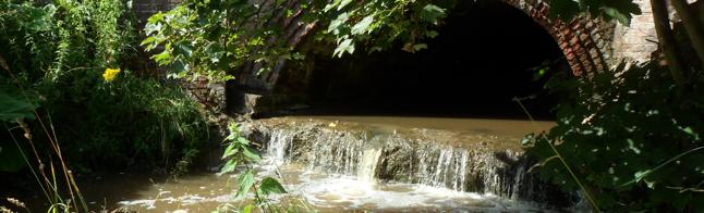
10 The Howls The Batts The Howls Here can be found protected ancient woodland mainly of ash and sycamore which has taken hundreds of years to establish. It plays an important role for wildlife, soils, history and cultural value. This is the only substantial area of ancient woodland in the Borough of Hartlepool. The Howls and The Batts are home to a recorded 53 species of birds, including owls, woodpeckers, skylarks, warblers and the spotted flycatcher during the summer. A number of small and large animals, including voles, bats, stoats, hares, badgers and roe deer make their home here. In The Howls the deer cross to the spinney running alongside the footpath to Elwick as this has a number of hedgerow food sources. Hedgerows are mainly hawthorn, elder and gooseberry. The bats can be seen leaving their roosts to forage particularly during dusk in the summer and can also be seen nesting in many houses and trees in the village. Notable flowers to be found at the two sites include early purple orchids, violets, lesser celandines and the uncommon in this locality, twayblades. At the bottom of The Howls Dalton Beck runs downstream into a Site of Special Scientific Interest, just before the bridge at the eastern end of the village. In this habitat can be found the rare water vole and other amphibians such as newts, frogs and toads.


11 Dalton Beck Dalton Beck gives the reserve an added dimension and plants that like damp conditions and soils thrive here; marsh marigolds, meadowsweet and the foreign invader Himalayan balsam. Dalton village is also fortunate to have the only remaining natural pond in Hartlepool. The pond is rich in amphibians such as newts, frogs and toads. Visitors include moorhens, coots, red admiral, peacock and painted lady butterflies and dragonflies. Hartlepool Borough Council have advocated protection of the countryside and has encouraged the enhancement of biodiversity. The parish fully endorses these goals and are committed to maintaining and preserving the unspoiled natural environments for people to enjoy and safeguarding them for future generations. x


12 The Built Environment The village includes many different styles, from the 1700 s such as Rose Cottage and The Priory to the Terrace from the turn of the 1900 s to modern developments such as College Close and Manor Fields from the 1970 s and Abbots Lea from the 2000 s. Whilst there is a range of developments all have followed the tradition of its history as a gated ribbon village. Within the village there are a number of infill plots for development that have been identified which will allow the village to grow whilst maintaining its historical layout. The village residents do not support any mass developments which either spoil its history or impact on the many special nature areas. In addition any development which requires access across the village green will require the granting of an easement from the parish council. The sites identified for future development are: - The Water Board Land between Leamount and Manor Farm. - The Stack Yard between The Terrace and The Priory. - The land adjacent to Manor Farm. - The land behind Rose Cottage. xi
13 Recommendations and Guidelines Protect the identity of the Parish of Dalton Piercy. Conserving and enhancing the distinctive historical, rural and environmental heritage of the area to maintain the character and vitality of the Parish. Conserving and enhancing the natural environment; Protect and enhance the high quality and sensitive landscape in and around the Parish and its contribution to the enjoyment of Dalton Piercy village. Maintain distinctive views and visual connectivity with the surrounding countryside. Recognizing the important contribution of the open spaces, wildlife areas and green infrastructure makes towards leisure, recreation and wellbeing. Providing Bio and Geo diversity. Locally essential assets not just for the residents of Dalton Piercy but Hartlepool as a whole. Improve the Parish public rights of way network making suitable routes for walking and cycling, Preserve existing access to views, (accessible for the needs of users. leisure and recreation should not be harmed.) Respect these routes, character, function and recreational value and support proposals which conserve or enhance these assets, such as wildlife corridors. Support proposals to protect and improve the assets of Dalton Piercy Parish: The village green, village stone wall, Village Hall, wildlife areas, footpaths, streams, hedgerows, woodland, meadows and allotments. High quality Development in keeping with surrounding; Ensure well designed, high quality infill development which reflects the heritage and distinctive character of Dalton Piercy. That development is not out of keeping with the design of surrounding housing and protecting the amenities of surrounding occupiers. Giving regard to the historic farming and natural environment in terms of local features from the existing landscape and character of heritage assets such as listed buildings. Ensure adequate provision for car parking in all new development. Ensure all those living within and passing through the Parish recognize Dalton Piercy as a home for its residents. Encourage close work with HBC and neighbouring villages to identify and agree ways to address transport and the current traffic infrastructure and safety issues. Encourage all those living within and passing through the Parish to recognize and take responsibility for ensuring the priority of road safety. Ensuring that the any development accommodates the impact of future climate change through actions such as the minimisation of hard landscaping and the village works to minimise the current flooding. To ensure that sewage is managed in an adequate and environmentally friendly way respecting the natural water ways in the adjacent wildlife areas. Support and encourage renewable energy provision. Support the activities of those working from home i.e. appropriate speed of broadband and mobile communications. Create opportunities for local residents Provide specific support for small scale employment initiatives. Support the development of tourist related facilities such as fishing lakes, quad bike track and horse riding schools. Building a healthy community promoting a prosperous rural economy. xii
14 Appendix 1 Residents Survey and Consulation Survey Residents of Dalton Piercy Village and surrounding area were either hand- delivered or sent a web survey. (68 households) What is the tenure of your house? Own with a mortgage 14 Own with no mortgage 12 Rent/council/housing association 2 Live with parents/relatives/friends 2 Rent from private landlord 0 Other 0 What kind of property is it? House 30 Bungalow 0 Other 0 Which of the following have you or your family used in the last 12 months? Any of the 3 village footpaths 25 The Batts Wildlife Area 22 The Village Pond 18 The Beck 17 The Howls Nature Reserve 15 Which of the following wildlife have you seen in and around the village in the last 12 months? Rabbit 29 Owl 26 Hedgehog 25 Moorhen 24 Bats 23 Frog/tadpole/frogspawn 22 Squirrel 21 Hare 19 Coots 18 Dragonfly 17 Stoats 16 Fox 14 Woodpecker 12 Deer 8 Newt 5 xiii
15 Activities Have you or your family engaged with any of the following in the last 12 months? DPPC as a public attendee 19 Village hall 18 DPPC 17 Village improvement group or activity 17 Allotment/Kids club 15 Litter picking 13 Carols around the tree 13 Rural Plan 13 Village Pots/Wheelbarrow 8 Other 1 What type of development would you like to see in the village? None 15 Development restricted to infill (inside the village band) sites 15 If you would like to see development, what types would you believe to be appropriate? Starter homes 16 Bungalows 6 Executive housing 3 Please indicate how you feel the current traffic volumes are for each of the following by selecting one of the following: Low, manageable, a problem, or dangerous. (29 replies) From A19 To A19 Greatham Backroad Dalton to Hartlepool Low Manage Problem Danger Please add anything else you feel should be included in our submission to the rural plan village design statement. Poor broadband Needs better roads and a bus service if many more houses are built While current traffic levels are manageable, increases in those levels to and from Hartlepool and the A19 through the village could cause problems especially as it is not uncommon to meet tractors, horse riders and cyclists on the narrow country road. Village infrastructure and improvements to the village itself to ensure the character is retained. Improvements to the internet and some of the internal car parking issues would be a benefit also. Save village greens by stopping car parking and digging up the turf xiv
16 Not sure if this is even relevant, but the phone line communications to the village are extremely poor. I don t know anywhere else that suffers such low speeds (0.9megabits) in a time where streaming data is becoming the norm. Cars travel through the village and along the country roads far too fast Cars coming through the village often go over the speed limit- dangerous as no footpath (continuous) through the village and young children live in the village. Permanent public transport We need a road to A19 south to stop through traffic. I see vehicles from throston who choose village rather than past hard on a regular basis. This will be much worse when development is started. Traffic problems will increase due to new development opposite High Tunstall and near Greatham using Dalton Road as a short cut to A19 already a problem with current traffic volumes using too narrow roads. Survey Document Source: 30 replies have been received. The survey was conducted by Dalton Piercy Parish Council and residents were given three weeks to reply. The data will be used in the Dalton Piercy Village Design Statement, which will be supplementary to the Rural Plan. Survey information collated by Sophie Chapman DPPC Clerk and Cllr. Burroughs. Produced by Cllr. Burroughs, Dalton Piercy Parish Council. Village Design Statement Source Consultation: Dalton Piercy Parish Council sought 3 volunteers from the Parish Council together with members of the Village Improvement Group to engage with residents and other stake holders over a 6 month period. The group has met regularly with members of the public at the Village Improvement Group meetings over the period of developing the plan. The draft plan has been made available on the Dalton Piercy Website and residents were invited to comment and respond. In addition to engaging residents at these meetings 2 surveys were undertaken, the surveys were both circulated electronically and delivered in hard copy to every household in the parish to ensure as many residents as possible have had the opportunity to input. In addition to residents the group also sought the views and input from Hartlepool Borough Council, Tees Valley Wildlife Trust, Elwick Parish Council and Greatham Parish Council. xv
LONGDEN VILLAGE DEVELOPMENT STATEMENT
 LONGDEN VILLAGE DEVELOPMENT STATEMENT 2017-2027 1 Longden Development Statement 2017-2027 15/01/18 1. Background 1.1 Longden Village Longden village is a very rural and traditional community first mentioned
ALLERTHORPE NEIGHBOURHOOD PLAN
 Allerthorpe s Neighbourhood Plan sets out a vision for the Parish for the next 15 years (2018 2033) that builds on and reflects the opinions and views of parish residents. VISION In 2033 Allerthorpe will
East Harptree Landscape & Character Assessment
 East Harptree Landscape & Character Assessment Produced by East Harptree Parish Council in consultation with local residents September 2014 Contents The Parish of East Harptree: Objective Introduction
About 10% of the Borough's population lives in the seven rural parishes. Population figures from the 1991 census are given below:-
 8. THE DISTRICT VILLAGES 8.1 Population About 10% of the Borough's population lives in the seven rural parishes. Population figures from the 1991 census are given below:- Village No. of Persons Cottingham
If you require support to complete this form please contact Jim Holford who will arrange suitable support to meet your needs
 If you require support to complete this form please contact Jim Holford who will arrange suitable support to meet your needs Jim Holford 1 Hillside Farm Chacewater TR4 8LU 07584135801 jimholford@gmail.com
Our City Centre is a vibrant, creative and welcoming destination, with a modern business, cultural, shopping, leisure and residential offer
 3. Sheffield in 2034 Our City sits at the heart of a strong, distinctive and internationally successful City Region economy which supports innovation and enterprise Our City Centre is a vibrant, creative
Environment Agency Flood Risk Map for the Village of Bridge
 Environment Agency Flood Risk Map for the Village of Bridge December 2016 21 Objective F. Conserving and Enhancing the Natural Environment The National Planning Policy Framework states that the planning
NON-TECHNICAL SUMMARY
 NON-TECHNICAL SUMMARY THE HIDE, BISHOP AUCKLAND PROPOSED ECO CHALET DEVELOPMENT NON-TECHNICAL SUMMARY 1 Introduction 1.1.1 This non-technical summary for the (ES) prepared in relation to the proposed eco-chalet
Planning and Sustainability Statement
 Land adjacent to Manor Farm, Catterick Village Pallett Hill Sand and Gravel Co Ltd Proposed 10 new dwellings, (6 No market dwellings and 4 No affordable dwellings) with access, associated car parking and
Statement of Community Involvement LAND OFF SOUTHDOWN ROAD HORNDEAN, HAMPSHIRE
 LAND OFF SOUTHDOWN ROAD HORNDEAN, HAMPSHIRE CONTENTS Page 1. Introduction 3 2. Pre-application Discussions 4 3. The Consultation Process 5 4. Consultation Feedback 7 5. Responses to Consultation Feedback
Full Name /title*. Address 1. Address 2 Post Code* *.. Phone* *Required fields for draw
 You can return this later to post boxes at: the Parish Council Office, Rowney Green Village Hall, The Petrol Station at Hopwood, or the Library. Closing date 14 th March: Draw on 14 th April 2014 at Alvechurch
3. Neighbourhood Plans and Strategic Environmental Assessment
 1. Introduction This report sets out a draft Screening Determination for the Preston Parish Council s Neighbourhood Plan and has been prepared by rth Hertfordshire District Council. The purpose of the
Hartlepool Rural Neighbourhood Plan Publication Draft
 Hartlepool Rural Neighbourhood Plan 2016 2031 Publication Draft Draft submitted to Hartlepool Borough Council August 2016 FOREWORD The Hartlepool Rural Planning Group was formed from representatives of
The Gwennap Parish Vision Statement
 QUICK GUIDE What is a Neighbourhood Development Plan? Ultimately it is a document used by developers or anyone wishing to submit a planning application that describes the vision, strategy, plans, regeneration,
Copyright Nigel Deeley and licensed for reuse under this Creative Commons Licence
 1 Copyright Nigel Deeley and licensed for reuse under this Creative Commons Licence Prepared by the Neighbourhood Plan Steering Group on behalf of Garway Parish Council with assistance from 2 Table of
Public Consultation. Land at Monks Farm, North Grove. Welcome
 Welcome Welcome to our public exhibition for development on Land at Monks Farm, orth Grove. Gallagher Estates and Gleeson Strategic Land are preparing an outline planning application for new homes, open
Neighbourhood Planning Guidance Local Green Spaces
 Neighbourhood Planning Guidance Local Green Spaces Introduction This guidance note has been produced for communities preparing neighbourhood plans in North Dorset to help them to identify, assess and designate
Land at Rampton Road. Cottenham
 Land at Rampton Road Cottenham Introduction TEP is preparing an outline planning application for 54 dwellings on 6.9 hectares of land adjacent to Rampton Road, Cottenham on behalf of the owners Cambridgeshire
Environmental and Landscape Mapping
 Environmental and Landscape Mapping In support of the Calveley Neighbourhood Plan November 2016 Project Name and Number: Calveley Neighbourhood Plan 16-025 Document Name and Revision: Environmental and
Draft Submission of Chilcompton Parish Council to Mendip Local Plan
 Draft Submission of Chilcompton Parish Council to Mendip Local Plan Note: This is a draft for consultation. The Parish Council urges all villagers and other stakeholders to send comments to: parishclerk@chilcompton.org.
Welford-on-Avon Neighbourhood Plan Consultation Event Sunday, 6 April Your name Your address
 Welford-on-Avon Neighbourhood Plan Consultation Event Sunday, 6 April 2014 Your name Your email address Please either: - complete this feedback form and put it in the box before leaving the Memorial Hall
Basic Habitat Survey Tabernacle Gardens, Pembroke
 Basic Habitat Survey Tabernacle Gardens, Pembroke Produced by The Wildlife Trust of South and West Wales Contact Ecologist: Position: Nathan Walton Wildlife Trust Officer Registered Office: Wildlife Trust
Neighbourhood Plan Representation
 Date: 10 th November 2017 Neighbourhood Plan Representation Land to the east of Callow Hill Road, Alvechurch Introduction This representation has been prepared by RPS Planning and Development on behalf
Stratford Neighbourhood Plan Questionnaire
 Stratford Neighbourhood Plan Questionnaire Please tick the appropriate box or answer in the space provided. If you require further copies of the questionnaire, as more than one person in the household
Neighbourhood Planning Local Green Spaces
 Neighbourhood Planning Local Green Spaces Introduction... 2 1. Why green space is important... 4 2. Neighbourhood plans and green space... 6 3. Evidence... 8 Statutory designations... 9 Green space audit...
Plumpton Parish Neighbourhood Plan. Local Green Spaces and Green Infrastructure
 Plumpton Parish Neighbourhood Plan Local Green Spaces and Green Infrastructure 1. Background The Parish of Plumpton lies within and adjacent to the South Downs National Park. The Plumpton Parish Neighbourhood
Hartlepool Rural Neighbourhood Plan Consultation Draft May 2015
 Hartlepool Rural Neighbourhood Plan 2015 2030 Hartlepool Rural Neighbourhood Plan P a g e 1 FOREWORD The Hartlepool Rural Planning Group was formed from representatives of the Parish Councils of Dalton
Schedule of Planning Applications Committee Date: 23 May Reference: 06/17/0726/F Parish: Hemsby Officer: Mr J Beck Expiry Date:
 Schedule of Planning Applications Committee Date: 23 May 2018 Reference: 06/17/0726/F Parish: Hemsby Officer: Mr J Beck Expiry Date: 22-05-2018 Applicant: Proposal: Site: Mr Gillett Change of use to the
Vigo Neighbourhood Plan Basic Conditions Statement
 Vigo Neighbourhood Plan Basic Conditions Statement Plan Period: 2016 to 2028 Status: Submission Version Qualifying Body: Vigo Parish Council Glossary of Some Terms & Abbreviations Used in this Document
ENVIRONMENTAL AND LANDSCAPE MAPPING
 APPENDIX IV : Environmental and Landscape Mapping ENVIRONMENTAL AND LANDSCAPE MAPPING Calveley Neighbourhood Plan November 2016 ENVIRONMENTAL AND LANDSCAPE MAPPING Calveley Neighbourhood Plan Calveley
WELCOME. North East Haverhill. The Planning Process
 WELCOME North East The site to the North East of, known as Great Wilsey Park, is identified by St Edmundsbury Borough Council in its Core Strategy as capable of delivering a Sustainable Urban Extension.
LOGGERHEADS NEIGHBOURHOOD PLAN LOCAL GREEN SPACE DESIGNATION OCTOBER 2016
 DRAFT LOGGERHEADS NEIGHBOURHOOD PLAN LOCAL GREEN SPACE DESIGNATION OCTOBER 2016 1. Introduction For many local communities, green infrastructure in and around their neighbourhood is an important issue,
Copyright Nigel Deeley and licensed for reuse under this Creative Commons Licence
 1 Copyright Nigel Deeley and licensed for reuse under this Creative Commons Licence Prepared by the Neighbourhood Plan Steering Group on behalf of Garway Parish Council with assistance from 2 Table of
Alder View. Introduction. Alder View. Harwell. The Vision. The Team. Taylor Wimpey
 Introduction Welcome to the public exhibition for, a development by Taylor Wimpey on the land south of Grove Road,. This exhibition will provide an overview of the development proposals for the site and
Parish of Repton NEIGHBOURHOOD DEVELOPMENT PLAN
 Parish of Repton NEIGHBOURHOOD DEVELOPMENT PLAN BASIC CONDITIONS STATEMENT December 2018 CEF 4 Legal Requirements This statement has been produced by the NDP Working Group on behalf of Repton Parish Council
DUNSFOLD NEIGHBOURHOOD PLAN Site Selection Policies
 DUNSFOLD NEIGHBOURHOOD PLAN Site Selection Policies The criteria for assessing sites for future housing and business development in Dunsfold are set out below. (Development criteria, covering what it is
STATEMENT OF OBJECTION TO THE PROPOSED DEVELOPMENT OF LAND AT CHURCH CLIFF DRIVE FILEY
 STATEMENT OF OBJECTION TO THE PROPOSED DEVELOPMENT OF LAND AT CHURCH CLIFF DRIVE FILEY You will be aware that Scarborough borough council have adopted a new local plan that includes land at Church Cliff
INTRODUCTION NORTH HEYBRIDGE GARDEN SUBURB
 INTRODUCTION This event is being hosted by the promoters of the proposed North Heybridge Garden Suburb who are working with Maldon District Council and other key stakeholders on the preparation of a comprehensive
WYNYARD NEIGHBOURHOOD PLAN
 WYNYARD NEIGHBOURHOOD PLAN 2017 2030 Grindon Parish Council with support from Elwick Parish Council Draft Version V2 April 2017 Rosemary Kidd MRTPI Planning Consultant Page 1 Contents: Foreword Page 1
DESIGN & ACCESS STATEMENT
 DESIGN & ACCESS STATEMENT January 2016 Contents Introduction section 1 Section 1 - Introduction Section 2 - Assessment Section 3 - Involvement Section 4 - Evaluation Section 5 - Design Section 6 - Layout
PLANNING DECISION NOTICE
 PLANNING DECISION NOTICE TOWN AND COUNTRY PLANNING ACT, 1990 Applicant WILLITON VILLAGE HALL STEERING COMM. C/O ALISON CALLOWWAY 54 NORTHCROFT WILLITON TAUNTON TA4 4RT Date Registered 11/08/2006 Application
To what extent do you agree or disagree with the four options?
 Issues and options questions The easiest and most effective way to respond to the consultation is by using our online consultation portal www.spelthorne.gov.uk/localplan However you can also email us at
Bluebell Beck, Middlesbrough
 Bluebell Beck, Middlesbrough Bluebell beck winds through meadows and woodland through Acklam between Brookfield to the A19 Mandale interchange. The Friends of Bluebell Beck is a group of enthusiastic volunteers
BREEDON NORTHERN LIMITED
 Non Technical Summary CONTENTS 1 INTRODUCTION... 1 2 SITE DESCRIPTION... 1 3 DESCRIPTION OF THE DEVELOPMENT... 6 4 NEED FOR THE DEVELOPMENT... 8 5 KEY ISSUES CONSIDERED IN THE ENVIRONMENTAL IMPACT ASSESSMENT...
Newcourt Masterplan. November Exeter Local Development Framework
 Newcourt Masterplan November 2010 Exeter Local Development Framework Background The Exeter Core Strategy Proposed Submission sets out the vision, objectives and strategy for the development of Exeter up
Great Easton Neighbourhood Plan Statement of Basic Conditions
 Great Easton Neighbourhood Plan 2017-2031 Statement of Basic Conditions OCTOBER 2016 GREAT EASTON PARISH COUNCIL Contents 1.0 Introduction....Page 2 2.0 Summary of Submission Documents and Supporting Evidence..
PROPOSED RESIDENTIAL DEVELOPMENT LAND AT GREEN LANE, YARM
 PROPOSED RESIDENTIAL DEVELOPMENT LAND AT GREEN LANE, YARM PUBLIC CONSULTATION YOUR VIEW MATTERS TO US LOCATION PLAN Thank you for taking the time to read this information leaflet regarding a proposed residential
March General enquiries: Web site:
 REDEVELOPMENT OF WILSON HOSPITAL FOR MITCHAM LOCAL CARE CENTRE Community Planning & Design Brief for Merton Clinical Commissioning Group and London Borough of Merton March 2016 1. Mitcham Cricket Green
Repton Parish Neighbourhood Development Plan - Consultation March 2017
 Repton Parish Neighbourhood Development Plan - Consultation March 2017 25 replies Policy No Comments Response H1 Agree 22 Amend to include Milton Road & footpath but exclude above footpath. Neither agree
How important is it to use our Neighbourhood Plan to try to find ways of improving the natural environment of the Parish?
 Question 15 Landscape and nature: How important is it to use our Neighbourhood Plan to try to find ways of improving the natural environment of the Parish? If you think it s important, where in the parish
Character Area Summary 6: Canal Zone Stonehouse Town Character Assessment, Bridgend Works from Downton Road
 Character Area Summary 6: Canal Zone An open area, with residential and industrial areas, which has a rural character and a rich historic and natural environment strongly influenced by the Stroudwater
SUSTAINABLE MANAGEMENT
 . Sustainable Management.1 The Concept of Sustainable Management The concept of sustainable management recognises there are limits to the use of natural and physical resources and there is a need to balance
CAERNARFON DEPENDENCY CATCHMENT AREA
 CAERNARFON DEPENDENCY CATCHMENT AREA GWYNEDD UNITARY DEVELOPMENT PLAN - HOUSING Map not to scale Dependency Catchment Area Location 2 Caernarfon Topic Housing To the rear of Bro Eglwys, Bethel. Grid Ref.
Briefing Document of CNP. June 2017
 Cholsey Parish Council Cholsey Neighbourhood Plan Briefing Document of CNP June 2017 Cholsey Neighbourhood Plan Page! 1 of! 8 Cholsey Plan Briefing v1.4 Page Left Intentionally Blank Cholsey Neighbourhood
8.0 Design and Form of Development 43/
 42/ 8.0 Design and Form of Development 43/ Rothwells Farm, Golborne/ Development Statement Figure 7. Site Constraints Key 44/ Site Boundary 360 Bus Route/Stops Existing Trees Underground Water Pipe Sensitive
PART 2 SOUTH DOWNS NATIONAL PARK AUTHORITY SECTION 1 SCHEDULE OF APPLICATION RECOMMENDATIONS
 42 PART 2 SOUTH DOWNS NATIONAL PARK AUTHORITY PLANNING COMMITTEE REPORT OF THE SERVICE MANAGER PLANNING DEVELOPMENT Applications to be determined by the council on behalf of the South Downs National Park
Preliminary Ecological Appraisal
 Preliminary Ecological Appraisal Seminar Outline What is Preliminary Ecological Appraisal (PEA)? What are the main objectives of PEA? Methods of PEA Wildlife legislation and planning policy Examples of
Wild about Bolnore. Welcome to Bolnore Village, situated in the beautiful West Sussex countryside. ResIDENTS INFORMATION GUIDE
 Wild about Bolnore Welcome to Bolnore Village, situated in the beautiful West Sussex countryside. Sustainability has been a key factor in the development of the village and considerable effort has been
Welford-on-Avon. Neighbourhood Development Plan Welford-on-Avon Parish Council
 Welford-on-Avon Neighbourhood Development Plan 2011-2031 Welford-on-Avon Parish Council Parish Consultation: Summary Version December 2014 January 2015 Foreword This is the latest version of the Welford
PLANNING COMMITTEE DATE: 07/09/2015 REPORT OF THE SENIOR MANAGER PLANNING AND ENVIRONMENT SERVICE CAERNARFON. Number: 4
 Number: 4 Application Number: C15/0034/37/LL Date Registered: 21/05/2015 Application Type: Full - Planning Community: Llanaelhaearn Ward: Llanaelhaearn Proposal: Location: Summary of the Recommendation:
Neighbourhood Planning Site Assessment Pro-forma and Guide Version 2
 Neighbourhood Planning Site Assessment Pro-forma and Guide Version 2 September 2014 Site HNP 006 Land East of Stanbridge Road and North of Lower Road 1. Background information Site location and use Site
South Worcestershire Development Plan. South Worcestershire Design Guide Supplementary Planning Document
 South Worcestershire Development Plan South Worcestershire Design Guide Supplementary Planning Document Statement of Consultation: Early Engagement Scoping Paper February 2017 1. Introduction 1.1 This
Watford Local Plan Part 2 Publication Stage Environmental Report. Appendix 3: Consultation Comments
 Watford Local Plan Part 2 Publication Stage Environmental Report Appendix 3: Consultation Comments August 2016 Appendix 3 - Responses to Consultation of the Local Plan Part 2 As required by the SEA Directive,
Basic Conditions Statement. Ugborough Neighbourhood Development Plan Giving our community more power in planning local development...
 Ugborough Neighbourhood Development Plan 2017-2032 Basic Conditions Statement Town and Country Planning Act 1990 (as amended) Paragraph 8(2) of Schedule 4B Statement Submission Date Giving our community
EXTRACT FROM THE CUDDINGTON NEIGHBOURHOOD PLAN The Policies
 EXTRACT FROM THE CUDDINGTON NEIGHBOURHOOD PLAN The Policies Environment and Landscape Policy 1 - Landscape Setting Development should respect and wherever possible enhance the landscape setting of Cuddington
Sutton cum Lound Neighbourhood Plan
 Sutton cum Lound Parish Neighbourhood Plan 2016-2031 Pre-Submission Consultation Version Sutton cum Lound Neighbourhood Plan 2016-2031 Sutton cum Lound Neighbourhood Plan Steering Group on behalf of Sutton
Effingham Neighbourhood Plan 1. Basic Conditions Statement
 Effingham Neighbourhood Plan 1 Basic Conditions Statement Effingham Neighbourhood Plan 2016: Basic Conditions Statement 2 Contents This statement has been prepared by Effingham Parish Council to accompany
Stanton Drew Parish Neighbourhood Plan Landscape and Environment
 Contents Introduction... 2 Scope of the Document... 2 Our Definition of a View... 2 Proposed Policies... 3 Criteria for a Protected View... 3 Views Assessed... 4 View 1: from cricket ground north towards
Cookham Parish Council s Response to The Draft Local Borough Plan
 Cookham Parish Council s Response to The Draft Local Borough Plan As Agreed at the Planning Committee Meeting on 10 th January 2017. Designation of Poundfield as a Local Green Space The Parish Council
Habitat Regulations Assessment (HRA) Screening Determination. May 2017
 Screening Determination. May 2017") Cholsey Parish Council Cholsey Neighbourhood Plan Habitat Regulations Assessment (HRA) Screening Determination May 2017 Cholsey Neighbourhood Plan Page! 1 of! 10 SASR - HRA v1.1 Page Left Intentionally
Cholsey Parish Council Cholsey Neighbourhood Plan Habitat Regulations Assessment (HRA) Screening Determination May 2017 Cholsey Neighbourhood Plan Page! 1 of! 10 SASR - HRA v1.1 Page Left Intentionally
Roeshot & Burton SANG. Hinton Admiral Estate
 Who we are? The Hinton Admiral is the home of the Meyrick family and the Estate today is a 300-year old organisation. The Estate enjoys very diverse land types which range from heathland and river valley
Elderberry Walk. Developer HAB Housing
 Case studies Elderberry Walk Developer HAB Housing Development of 161 new homes on the former Dunmail Primary School site, focused around a central green street, with retained trees, new multifunctional
ROCHFORD LOCAL DEVELOPMENT FRAMEWORK: Sustainability Appraisal/ Strategic Environmental Assessment. Rochford Core Strategy Preferred Options Document
 ROCHFORD LOCAL DEVELOPMENT FRAMEWORK: Sustainability Appraisal/ Strategic Environmental Assessment Non Technical Summary Rochford Core Strategy Preferred Options Document October 2008 SUSTAINABILITY APPRAISAL
Ashtead Neighbourhood Forum Site Assessment AS07 Old Chalk Pit, Pleasure Pit Road. Site ref: AS07 Site address: Old Chalk Pit, Pleasure Pit Road
 Site ref: AS07 Site address: Old Chalk Pit, Pleasure Pit Road Proposed Land Use: Total Site Area (Ha): Housing 0.7ha Description: The site was formally an old chalk pit that has been partially filled and
Welcome to our exhibition
 Welcome to our exhibition The Homes & Communities Agency (HCA) welcomes you to this public exhibition explaining our proposals for the redevelopment of the former Lea Castle Hospital site. About the Homes
Making the case for Sustainable Transport Project Potential
 Making the case for Sustainable Transport Project Potential The Structural Investment Fund (SIF) Strategy for Greater Lincolnshire identifies the barriers to growth identified by having poor transport
Site ref: AS06 Site Name or Address: Murreys Court, Agates Lane
 Site ref: AS06 Site Name or Address: Murreys Court, Agates Lane Proposed Land Use: Total Site Area (Ha): Housing 1.85 Ha Description: It is understood that the owner has no plans to dispose of the site
A Master Plan for High Park s Hillside Garden and other Ornamental Gardens: Recommendations from the High Park Natural Environment Committee
 www.highparknature.org mail@highparknature.org A Master Plan for High Park s Hillside Garden and other Ornamental Gardens: Recommendations from the High Park Natural Environment Committee September 2015
WELCOME. Land North of STEVENAGE. We would like to thank you for attending our public exhibition today.
 WELCOME We would like to thank you for attending our public exhibition today. The purpose of this event is to share our proposals and hear your thoughts on our ideas. Members of the project team are on
DONCASTER METROPOLITAN BOROUGH COUNCIL. PLANNING COMMITTEE - 15th October Expiry Date:
 DONCASTER METROPOLITAN BOROUGH COUNCIL PLANNING COMMITTEE - 15th October 2013 Application 3 Application Number: 13/01158/FUL Application Expiry Date: 31st July 2013 Application Type: Full Application Proposal
Wildlife and Planning Guidance: Neighbourhood Plans
 Wildlife and Planning Guidance: Neighbourhood Plans This Leaflet is one of a series of 4 Wildlife and Planning Guidance Leaflets and is intended to provide useful information to assist you to campaign
Welcome. Welcome to our first Open Day event
 Welcome We are here Welcome to our first Open Day event About us This is the first of many opportunities to have your say on the development of the. Urban&Civic was founded specifically to enable and deliver
Site Assessment Technical Document Appendix A: Glossary
 Central Bedfordshire Council www.centralbedfordshire.gov.uk Site Assessment Technical Document Appendix A: Glossary July 2017 1.1.11-1 - ii Appendix A: Glossary Term Agricultural Land Classification AONB
HIGH LITTLETON AND HALLATROW COMMUNITY PLACEMAKING PLAN
 HIGH LITTLETON AND HALLATROW COMMUNITY PLACEMAKING PLAN DOCUMENT 3 of 4 SNAPSHOT CHARACTER SUMMARY HALLATROW Context B&NES Landscape type: Area 6 Farrington Gurney Farmland/ Area 12 Cam and Wellow Brook
CLEVE PARK, THORNBURY
 CLEVE PARK, THORNBURY Community Planning Day Report Back Broadsheet February 206 A VISION FOR CLEVE PARK Over 0 local people attended the Cleve Park Community Planning Day at Armstrong Hall on Saturday
Frequently Asked Questions
 1. Where is Aylesbury Woodlands? Frequently Asked Questions Aylesbury Woodlands lies to the east of Aylesbury. It is bounded to the south by the A41. To the north is the Aylesbury Arm of the Grand Union
PLANNING STATEMENT. Market House Market Place Kingston upon Thames KT1 1JS
 PLANNING STATEMENT To support planning and listed building consent applications for change of use from Class A1 shop and Class A3 cafe to Class A3 restaurant at: Market House Market Place Kingston upon
Bridge Neighbourhood Plan
 Bridge Neighbourhood Plan Consultation Draft October 2014 Bridge Neighbourhood Plan Draft 1.4 October 2014 Introduction This Plan sets out our vision for the future of Bridge from now until 2030 and lays
Rochford District Council Allocations Development Plan Document: Discussion and Consultation Document Sustainability Appraisal
 Option SWH1 Balanced Communities Option SWH1 1 To ensure the delivery of high quality sustainable communities where people want to live and work Will it ensure the phasing of infrastructure, including
The eight-week period for this application expires on 5 October 2006.
 06/01213/FUL CHANGE OF USE FROM AGRICULTURAL LAND TO PRIVATE CAR PARK AND NEW FENCING. AT Land To The South of Perceval Almhouses, Lower Weald, Calverton FOR Calverton Parochial Church Council INTRODUCTION
The journey so far. The new masterplan for Dargavel Village
 The journey so far Our vision for Dargavel Village began over ten years ago when the original masterplan for transforming the former Royal Ordnance Factory site into a thriving community was established.
Stantonbury Neighbourhood Plan
 Stantonbury Neighbourhood Plan 2018-2031 Basic Conditions Statement October 2018 Intentionally blank 1.0 Basic Conditions Statement Introduction 1.1 This statement has been prepared by Stantonbury Parish
A BEAUTIFUL PLACE FOR LIVING
 A BEAUTIFUL PLACE FOR LIVING BEAULIEU: A PLACE FOR LIFE Beaulieu is a vibrant new district taking shape in Chelmsford, Essex; offering residents inspirational architecture and landscape. Developers Countryside
Applicant: Mr C Fletcher Agent: Ms B Stala Case Officer: Sally Smith (HBC) Jill Lee (WCC) Ward: Stakes Parish Southwick and Widley
 Jill Lee (WCC) Ward: Stakes Parish Southwick and Widley") Site Address: Berewood Phase 2 Development Site, London Road, Purbrook, Waterlooville Proposal: Reserved Matters Application for landscaping of Phase A of the Town Park (under Condition 6(i)d)), together
Site Address: Berewood Phase 2 Development Site, London Road, Purbrook, Waterlooville Proposal: Reserved Matters Application for landscaping of Phase A of the Town Park (under Condition 6(i)d)), together
The targets do not adhere to the government projections or methodology, being aspirational rather than achievable.
 Question 1: Preferred Growth Option (see pages 7-9 of the consultation document) Do you agree with the preferred growth option for the Joint Local Plan? The targets do not adhere to the government projections
WELCOME GYPSY LANE. Wider Site Location plan. Proposals for the development of LAND OFF FOXLYDIATE LANE WEBHEATH. Proposals for the development of
 WELCOME The developers are preparing an outline planning application for a residential led development and need the community s views in order to develop the proposals further WHAT IS PROPOSED? A high
1.3 The following table presents a Statement of Compliance demonstrating how the Standish Neighbourhood Plan meets those requirements.
 1. Introduction 1.1 This Basic Condition Statement was prepared to accompany the draft Standish Neighbourhood Plan (2018). 1.2 Paragraph 8 of Schedule 4B of the Town and Country Planning Act 1990 requires
Rotherhithe Rotherhithe Area Vision Map
 Area Vision Map CWAAP1 Improved pedestrian and cycle links to the wider area Improved link from town centre to River Thames and docks CWAAP2 Brunel Museum NSP79 CWAAP3 Proposed Thames Crossing Station
WELCOME TO THE NEW WILTON PARK
 WELCOME TO THE NEW WILTON PARK VISION HISTORY OF WILTON PARK TOWARDS A PLANNING APPLICATION Our objective is to create a truly outstanding environment at Wilton Park. At the heart of our proposals is a
Kibworth Harcourt. Introduction. Introduction
 Introduction Introduction Welcome to this public exhibition on the proposals for the delivery of new homes on land at The Kibworths. The purpose of today s exhibition is to give you the opportunity to