Neighbourhood Plan. (Conceptual Scheme) NW ¼ & Portion of SW ¼ of Section W4M. September 26, 2017 Approved Version
|
|
|
- Marilyn Maryann Richardson
- 6 years ago
- Views:
Transcription

1 Neighbourhood Plan (Conceptual Scheme) NW ¼ & Portion of SW ¼ of Section W4M September 26, 2017 Approved Version Qualico Communities 100, nd Street SE Calgary, AB T2H 2W4 B&A Planning Group 600, Ave SW Calgary, AB T2P 3T1

2 Project Team Acknowledgements Submitted by: Qualico Communities Prepared by: B&A Planning Group Planning and Urban Design In Association With: BSEI Municipal Consulting Engineers Civil Engineering Bunt & Associates Transportation Engineering Transportation Planning LGN Consulting Engineering Stormwater Management Aresco Ltd. Social and Earth Sciences Research Historical Resources Assessment Ecotone Environmental Ltd. Wetlands and Biophysical Assessment Base Property Consultants Ltd. Environmental Site Assessment McIntosh Lalani Engineering Ltd. Geotechnical Assessment LA West Landscape Architecture Altus Group Economic Consulting Market Analysis TBD Fiscal Impact Analysis
3 Neighbourhood Plan NW ¼ & Portion of SW ¼ of Section W4M Prepared for Rocky View County Ave NE Calgary, Alberta, T2E 6X6 Submitted by Qualico Communities 100, nd Street SE Calgary, AB T2H 2W4 Prepared by B&A Planning Group 600, Ave SW Calgary, AB T2P 3T1 Date September 26, 2017 Version APPROVED
4 Table of Contents & Figures Section No. 1 INTRODUCTION Natural Environment Neighbourhood Plan Purpose User Guide to this Plan The Future of Langdon EQWell A Qualico Communities Initiative Neighbourhood Plan Goals Public Engagement 06 Section No. 2 PLAN AREA DESCRIPTION & EVALUATION 2.1 Location Land Use and Ownership Land Use Context Reserve Analysis Emergency Services Transportation Utility Services Stormwater and Geotechnical Conditions Solid Waste & Recycling Oil and Gas 70 Section No. 5 IMPLEMENTATION 5.1 Plan Implementation Phasing Section No. 3 PAINTED SKY DEVELOPMENT CONCEPT 3.1 Guiding Principles 15 Section No. 4 PLAN POLICIES 4.1 Land Use Strategy Residential Policy Gateway Node Appendix A SITE EVALUATION Appendix B DEVELOPMENT RATIONALE Appendix C OPEN SPACE LANDSCAPE CONCEPTS Appendix D POLICY FRAMEWORK Appendix E TECHNICAL AND SUPPORTING STUDIES Schools Assessment Recreation, Cultural, and Community Uses Open Space, Parks, Pathways and Trails 39 i PAINTED SKY IN LANGDON NEIGHBOURHOOD PLAN
5 Fig. 1 Painted Sky Context 11 Fig. 2 Existing and Adjacent Land Uses 13 Fig. 3 Site Context 14 Fig. 4 Illustrative Concept 17 Table 1 Land Use and Ownership Location 12 Table 2 Primary Land Use Policy Areas 20 Table 3 Land Use Statistics 21 Table 4 Reserve Analysis 48 Fig. 5 Concept Plan 22 Fig. 6 Commercial Nodes & Pedestrian Connections 35 Fig. 7 Langdon School Analysis & Ped. Connections 37 Fig. 8 Open Space Plan 41 Fig. 9 Regional Transportation Plan Off-Site Improvements 52 Fig. 10 Transportation Plan 54 Fig. 11 Pedestrian Circulation 56 Fig. 12 Collector Cross Sections for Local Roadway 57 Fig. 13 Collector Cross Sections for Brander Avenue 58 Fig. 14 Regional Water & Sanitary Servicing 58 Fig.15 Water Servicing Plan 62 Fig.16 Sanitary Plan 63 Fig. 17 Regional Storm Discharge & Off-Site Improvements 66 Fig. 18 Stormwater Servicing Plan 67 Fig. 19 Phasing Plan 72 Fig. 19A Anticipated Lot Widths for Phase 1 and 2 73 QUALICO COMMUNITIES APRIL 2017 ii
 located on the west side of the Langdon.")
6 Section N o. 1 Introduction 1.1 Neighbourhood Plan Purpose The Painted Sky Neighbourhood Plan (Conceptual Scheme) has been prepared for Rocky View County on behalf of Qualico Communities. The plan affects the NW 1/4 and a portion of SW 1/4 of Section W4M comprising approximately ± HA (± acres) located on the west side of the Langdon. This policy document is to be used to guide future land use, subdivision and development permits within the plan boundary. Rocky View Council will consider adoption of this Neighbourhood Plan by Bylaw forming a non-statutory policy document. Conceptual Schemes are developed within the framework provided by an area structure plan. Based on this framework, the Neighbourhood Plan (Conceptual Scheme) must demonstrate how development in the local area will retain the integrity of the overall area structure plan planning concept and how development will be connected and integrated with adjacent areas. Policy sections in the ASP identify the unique requirements that must be addressed in the Neighbourhood Plan due to the location and specific development conditions of the area. The standard technical requirements of a conceptual scheme or master site development plan are identified in the Rocky View County Plan (Section 29 and Appendix C). 01 PAINTED SKY IN LANGDON NEIGHBOURHOOD PLAN
7 Section N o. 1 Introduction 1.2 User Guide to this Plan The Painted Sky Neighbourhood Plan is a companion document to the Langdon Area Structure Plan with its primary purpose to demonstrate consistency and determine suitability of the lands for the intended land uses. Supporting information is contained in the appendices of this document. Appendix A: Site Evaluation Painted Sky is described from a topographical perspective in this appendix. There are relatively minimal physical constraints to development on the subject land. Appendix B: Development Rationale Painted Sky is a logical extension of development in the community. The Development Rationale provides a series of sound planning reasons for why this development makes sense. Appendix C: Open Space Landscape Concepts A key characteristic of Painted Sky is the integration of open space features in strategic locations. Considerable attention has been given to landscaping for these areas, and these concepts are detailed in this appendix. Policy Framework and Technical and Supporting Studies To assist the reader with interpretation and reference, the relevant policy plans and technical supporting studies are listed in the second part of the Appendix of the document. It is recommended that the reader consult and have available the specific documents listed for further information and recommendations when reviewing this plan and its respective policy section. Appendix D: Policy Framework Relevant, provincial and local policy which has been used for guidance in the preparation of this document has been outlined in this appendix Agreements The ultimate success of a community plan can be credited to the foundation laid by direct consultation and agreements with a number of stakeholders reached throughout the planning process. Plan Interpretation The following describes the meaning of some of the key words that are contained in a policy: Shall: a directive term that indicates the actions outlined are mandatory and therefore must be complied with, without discretion, by Administration, the developer, the Development Authority, and Subdivision Authority. Should: a directive term that indicates a preferred course of action by Council, Administration, and / or the developer, but one that is not mandatory. May: Policies referencing this icon indicate the direct commitments made to community members, stakeholders and/or the County and have been added to the CS to mitigate concerns. a discretionary term, meaning the policy in question can be enforced by the County if it chooses to do so, dependent on the particular circumstances of the site and / or application. Appendix E: Technical and Supporting Studies In support of the preparation of this document and development concept a number of required technical and supporting studies have been prepared and submitted under separate cover as part of the review process by Rocky View County. These studies are listed in this appendix QUALICO COMMUNITIES APRIL

8 1.3 The Future of Langdon The neighbourhood of Painted Sky is a highly sought after, family-oriented community, designed from strong planning principles and a commitment to serving the housing, lifestyle and amenity needs of its residents. Painted Sky is a distinct prairie neighbourhood with small town attributes characteristic of rural Alberta. It is ideally suited for raising a family safe, contains an abundance of green space and natural areas, extensive pathways, walkable streets, environmental features, and a future school. Painted Sky has small town charm created through the prairie heritage architectural style reminiscent of original farmhouses, central common gathering areas, and a potential gateway node with local shops and services, and seniors opportunities. This new neighbourhood is a haven for families looking for an alternative to city living, but who still want the convenience of nearby schools, recreation, fire, police and emergency services. By 2025, Langdon will be a charming Hamlet nestled in its surrounding wetlands and agricultural lands. The community s character is rooted in its railway and early-settler heritage, while supporting modern lifestyles through a range of housing, employment, and amenity options. Centre Street provides a focus for meeting the daily needs of people in all stages of life. Residents and visitors travel a network of sidewalks and pathways throughout the community, and enjoy Langdon s parks, recreation facilities, and outdoor gathering spaces. (Langdon Area Structure Plan, p. 22) 03 PAINTED SKY IN LANGDON NEIGHBOURHOOD PLAN

9 Section N o. 1 Introduction 1.4 EQWell A Qualico Communities Initiative We create communities we believe in. Which is why we have created EQWell, an initiative built on a commitment to reduce our impact on the environment, provide ample places for outdoor activity and social gathering spaces and create innovative and diverse communities that cater to all stages of life. Careful planning and consideration has gone into creating each of our communities including Painted Sky. EQWell is comprised of three main pillars each providing guidance and structure to how Qualico develops and cares for their communities. Living Well Designing communities that promote a healthy lifestyle. Environmental Responsibility Commitment to environmental responsibility and reducing the ecological impact of our communities. Social Responsibility Implementing a responsible social influence, including such things as diverse housing options and creating safe communities. We create communities we believe in.
10 1.5 Neighbourhood Plan Goals To align with the community vision, land use strategy and goals of the Langdon Area Structure Plan, six broad themed neighbourhood plan goals have been used for guidance and form foundational elements for the creation of the Painted Sky Development Concept. These goals ensure alignment with the Langdon Area Structure Plan. 1] Create a Great Place to Live. Build an enduring community that includes walkable neighbourhoods, parks, pathways and community amenities with a strong sense of place for people, young and old, to enjoy; 2] Sustainability. Commitment to achieve the best possible economic, social, and environmental outcomes for the neighbourhood and community of Langdon; 3] Land Use and Neighbourhood Design. To determine the appropriate type and location of proposed land uses and their distribution in the proposed neighbourhood, including high level building, street and open space concepts along with the target density for the neighbourhood; 4] Land Suitability and Policy Alignment. Demonstrate the suitability of the subject lands for development by providing a comprehensive development framework grounded in the vision and policies of the Langdon ASP; 5] Infrastructure Improvements. Focus on connections to existing infrastructure to ensure private investment generates the maximum benefit for the community. Establish a strategy to implement appropriate transportation and utility infrastructure improvements and any required off-site improvements; and 6] Meaningful Engagement and Consultation. To undertake community consultation and engagement in order to ensure land use policies and community design will respond appropriately to community concerns. 05 PAINTED SKY IN LANGDON NEIGHBOURHOOD PLAN
11 Section N o. 1 Introduction 1.6 Public Engagement Public consultation during preparation of the Painted Sky Neighbourhood Plan included a number of open house meetings and information sessions along with direct consultation with affected community members. JUNE 2006 June 21, 2006 An open house was held at the Langdon School from 7:00 pm to 9:00 pm. This open house was advertised in the Rocky View Weekly for two consecutive issues prior to the scheduled open house. The purpose of this open house was to discuss the concept of a new community in the area with adjacent neighbours and to adapt the plan to accommodate the preferences of neighbours wherever possible. Approximately 30 people attended this open house, with four comment sheets completed. Respondents noted that they wanted to maintain the small-town feel to the community, with more single-family development, parks and open space, a local grocery store, a hockey rink and other small town amenities. NOV November 14, 2011 A meeting of the Bow North Recreation Board was held with B&A Planning Group presenting a concept that was developed over The Board expressed its desire for active play areas and pathways due to its currently active and family-oriented population. WINTER 2017 January 16, 2017 A second public open house meeting was held in the Winter of 2017 to provide updates and changes following the recently adopted Langdon Area Structure Plan. The open house and engagement program is described in the following pages. QUALICO COMMUNITIES APRIL

.")


12 You re receiving this information sheet because we want to take the opportunity to inform you of the Painted Sky Conceptual Scheme and land use application for the development within the NW ¼ & Portion of SW ¼ of Section W4M by Qualico Communities. The application is currently under review by Rocky View County. Our proposed development is envisioned to be a distinct prairie residential community located on the west side of Langdon. Painted Sky will be primarily single-family housing along with some alternate housing forms (i.e. townhouses and semi-detached as the market dictates). The community will be ideally suited for families and other citizens. This small town community is comprehensively planned with a range of lots sizes, a school site, a gateway node, significant parks and open space, and an interconnecting pathway system. Qualico was founded more than 60 years ago and is in the business of creating homes and communities where people can put down roots and raise their families. Our team has been working on a rural vision for this location for nearly ten years. We are currently meeting with our neighbours and the broader community to gather feedback on our plan and answer any questions, comments or concerns. We value your input every step of the way and we look forward to hearing from you. Respectfully, Information Session January 16, 2017 You are invited to join us on Monday, January 16th, 2017 for an open house information session. The open house will give you a chance to meet with the development team, view the concepts, ask questions and be involved in the planning process for Painted Sky! Monday, January 16 th, :00 pm 9:00 pm Langdon Field House 251 Whitney St NE, Langdon Given that many landowners and stakeholders have changed since 2006, Qualico undertook an extensive public engagement program in to reach out to all new affected landowners and stakeholders for input on the revised plan. On January 16th, 2017 the Painted Sky team hosted a public open house at the Langdon Field House. During the two hour event, nearly 150 nearby residents came by to review the Neighbourhood Plan and to learn more about the proposed development. The open house was a culmination of a two month long public engagement campaign that included an informational project flyer, mail drop postcard invitations, newspaper advertisements and a website launch with a dedicated stakeholder relations domain to field general inquiries and respond to local concerns. The Painted Sky team followed up with open house participants and other stakeholders by administering an online survey. The objective of the survey was to further refine the Painted Sky concept plan and to ensure that Painted Sky becomes a well-integrated addition in the greater Langdon community. The survey received 20 unique participants who responded to a series of qualitative and quantitative questions with dedicated space to provide comments on design specifications including lot sizes, green space and transportation networks. A number of strategies were used to create an effective engagement and communication approach with the surrounding community and other stakeholders. Objectives were outlined primarily to raise awareness with the community, provide opportunity for feedback, and allow the community to stay current with the project prior to consideration of the plan by Council. A What We Heard Report was prepared and made available to the public to report back to the community and that we have heard. These techniques included: Temporary Signage on the 4-way main stop into town and at the Langdon Field House YOU RE INVITED TO OUR Please join us to learn more about the Painted Sky Langdon Neighbourhood Plan. The open house will give you a chance to meet with the development team, view concepts, ask questions and learn more about Painted Sky. Public Open House Painted Sky Neighbourhood Plan Public Open House Monday, January 16, :00 p.m. to 9:00 p.m. Vale View Rd. Glenmore Tr. / Highway 560 Centre St. Langdon OPEN HOUSE Railway Ave. / Twp Rd. 233B Open House Invitation distributed to 1034 residents within expanded circulation area Langdon Field House 251 Whitney Street NE, Langdon Access via Langdon Park For more information, please visit our website paintedskyinlangdon.com Ad in (print/online) along with Langdon News Community Event Listings Ad in (print/online) Rocky View Weekly and Langdon News Media Interview for Rocky View Weekly Dear Neighbour, OPEN HOUSE The Painted Sky Development Team Personal Invitations sent to 11 local organizations and key stakeholders paintedskyinlangdon.com 07 PAINTED SKY IN LANGDON NEIGHBOURHOOD PLAN

13 Section N o. 1 Introduction Open House At-a-Glance 138 ATTENDEES ON JANUARY 16, FEEDBACK FORMS FILLED OUT 80 COMMENTS ON THE FEEDBACK FORMS 161 SUBSCRIBERS FOR NEWSLETTERS 04 PHONE INQUIRIES RECEIVED ABOUT THE PROJECT 18 INQUIRIES RECEIVED ABOUT THE PROJECT Open House Attendees QUALICO COMMUNITIES APRIL
14 Several themes emerged from the feedback: Housing A dominant theme of the feedback received was regarding the proposed lot sizes in painted Sky. While many people expressed satisfaction with a diversity of lot sizes and housing types, some residents are concerned that lot sizes under 60 feet in width will hinder Painted Sky s integration into the hamlet. It was revealed in our face-to-face conversations and through the feedback forms that there was some confusion about lot sizes in the development. Another theme was the public s response to the potential for seniors housing in Painted Sky. Residents spoke with members of the development team at the open house to articulate the need for improved options for seniors housing in the hamlet. Infrastructure Upgrades & Servicing A theme of concern among some of the open house attendees was the growing need for infrastructure upgrades including water, sewer, and stormwater management. Residents expressed concerns about the number of proposed new developments in th Langdon area that are slated for construction prior to the announcement of any infrastructure upgrades, Painted Sky being one of them. Approximately 80% of the homes will be single family with an average 50 foot lot width. 10% of the product will accommodate smaller, single family homes on lots with an average width of 34 feet. The proposed plan also includes a 10% multi-family housing component that would be duplexes and townhomes. The ultimate mix and distribution of housing types will be determined by market demand and Council approvals A typical new community in the City of Calgary averages 8-10 Units per acre in residential density. The planned density for Painted Sky is 4.56 unit per acre while still being able to provide a range of housing forms and meet the requirements of the Langdon ASP. The county and Langdon Water works are responsible for future upgrades to servicing infrastructure in the Hamlet of Langdon. Developers pay servicing levies on a per acre basis that support future infrastructure upgrades The storm pond designed to handle Painted Sky runoff will be a wet pond and sized to accommodate up to a 1:500 year storm event. The volume of the Painted sky Pond has allowed for contribution from off-site lands including portions of Vale View Road and the future development of the former railway lands lying to the south of the Painted Sky Planning area (south of Railway Avenue). Water supply has been confirmed with Langdon Waterworks to service this development and provision of services will be verified with application for each phase of subdivision. Provision of water to each phase will be planned in association with Langdon Waterworks infrastructure projections and the staged upgrading of their water treatment plant and distribution system. Wastewater generated by the Painted Sky development will be conveyed via gravity to a proposed new wastewater lift station located adjacent to the storm pond in the southeast portion of the plan area. The proposed lift station will convey the wastewater flow via force main to the 600 mm force main that connects Balzac to the Langdon Wastewater Treatment Facilities with ultimate discharge of treated effluent being released into the Weed Lake wetland. Upgrades to the wastewater treatment plant are planned to accommodate future growth. 09 PAINTED SKY IN LANGDON NEIGHBOURHOOD PLAN

15 Section N o. 1 Introduction Transportation & Site Access Surrounding residents wanted to ensure that the development is accompanied by traffic solutions to address concerns regarding access points, movement within, to and from the site, and any additional road or infrastructure upgrades that may be required to accommodate new development and help to reduce impacts on the adjacent residents. Green Space Summary of feedback suggests that the vast majority of open house attendees and feedback form respondents are pleased with the amount of green space, open space, and park space within the development. The proposed plan has a total of eight parks and designated open spaces to support the community s need for recreation areas and for Langdon to maintain elements of country living while having the conveniences of a residential subdivision. This whole project will be a fantastic compliment to Langdon! The neighbourhood would be more complete with a few business or retail options. We need more convenience stores and little coffee shops to serve our residents better, and to bring new jobs into the community too. We own a small business here and have lost good employees due to unaffordable housing options here the multifamily and townhome options are in huge demand here! The plan looks great you strike a good balance between residential and open spaces to make the neighbourhood feel like a real Langdon community Brander Avenue will be extended through to Vale View Road and would be built to a core collector standard (10.6 m/21.0 m R/W). Vale View Road will have two accesses and Railway Avenue will have two accesses. No new access to Glenmore is currently proposed, however traffic calming will be provided to address concerns about speeding along Brander Ave. In general, the most common sentiment echoed throughout the evening and through the feedback forms was support for growing the Langdon community and keen interest in the amenities of Painted Sky. Local resident feedback largely agreed that the proposed new neighbourhood would be a good fit in Langdon given that the lot sizes and offering of housing types are in alignment with the diverse needs of the greater community. QUALICO COMMUNITIES APRIL
 Glenmore Trail (HWY 560) The Painted Sky Neighbourhood Plan area is located in Langdon, The plan area affects the NW 1/4 and a portion of the SW 1/4 of Rocky")
16 Section N o. 2 Plan Area Description 2.1 Location Vale View Road (RGE RD 273) Glenmore Trail (HWY 560) The Painted Sky Neighbourhood Plan area is located in Langdon, The plan area affects the NW 1/4 and a portion of the SW 1/4 of Rocky View County, approximately 20 minutes east of the city of Section W4M comprising approximately ±107.9 HA Hamlet Calgary. The lands are located immediately south of Provincial of (± Langdon acres) located on the west side of the Langdon. The Highway 560 (Glenmore Trail), east of Range Road 273 (Vale area is currently comprised of three titles as described in Table View Road) and north of Township Road 233 (Railway Avenue). 1. Qualico Communities has been engaged with the community The existing neighbourhood of Langdon Crossings West and and County respecting the planning of a new community for the proposed neighbourhood of Mornington are located these lands since These efforts and recent participation immediately to the east. in the preparation of the Langdon Area Structure Plan has set the foundation for this policy document. This section provides a brief description of the lands. Railway Avenue (TWP RD 233A) Railway Avenue (TWP RD 233A) Figure 1 Painted Sky Context Glenmore Trail (HWY 560) Glenmore Trail (HWY 560) Vale View Road (RGE RD 273) Hamlet of Langdon Railway Avenue (TWP RD 233A) Railway Avenue (TWP RD 233A) Vale View Road (RGE RD 273) NW W4M SW W4M Conceptual Scheme Boundary Glenmore Trail (HWY 560) Railway Avenue (TWP RD 233A) 11 Sep 23, :46pm W:\911 Painted Sky\DWG\911-CS SEPT23.dwg Legend PAINTED SKY IN LANGDON NEIGHBOURHOOD PLAN (RGE RD 273) NW W4M Conceptual Scheme Boundary Painted Sky Conceptual Sc N Figure Regional C Portion of W 2 1 Section 22- Septem
17 Section N o. 2 Plan Area Description & Evaluation 2.2 Land Use and Ownership The planning area consists of approximately ±107.9 HA (± acres) of predominantly cultivated agricultural land, legally described as the NW 1/4 of Section W4M and a portion of the SW 1/4 of Section W4M. West Langdon Developments Ltd. is a joint venture with Qualico Communities as its managing partner. The Neighbourhood Plan also includes the existing ±1.62 (±4.0 Acre) acreage that had been previously subdivided by description. Table 1 Land Use and Ownership Location Acres Hectares Owner Land Use 1. NW W4M ± ± West Langdon Developments Ltd. RF 2. Portion of SW W4M ± ± West Langdon Developments Ltd. RF 3. Portion of SW W4M ±4.0 ±1.62 Mike Allan & Heather Allan R-3 TOTAL AREA ± ± Land Use Context The general vicinity in and around Langdon has experienced considerable development pressure and this is attributed to its close proximity to the City of Calgary and strong growth in the region. Robust growth combined with rising land prices continue to provide incentives for businesses and individuals to locate outside the city s boundaries. Rocky View County is expected to continue to experience strong growth rates as people seek alternatives to living in the city of Calgary. Lands immediately north, west and south of the subject lands are agricultural containing farmsteads and some country residential development. The lands to the east of the subject lands, are anticipated for residential development and are guided by the Langdon Crossings West (2005) and Mornington (2011) Conceptual Schemes. Langdon Crossings West is predominately built-out as a residential single family community and Mornington has not yet proceeded to the development stage. PAINTED SKY QUALICO IN LANGDON COMMUNITIES NEIGHBOURHOOD APRIL 2017 PLAN 12
18 Figure 2 Existing and Adjacent Land Uses F NE FRF RF RF NE F RF F RF NE NE SE RF SE RF NE RF NE RGE. RD 273 (VALE VIEEW ROAD) RGE. RD 273 (VALE VIEEW ROAD) RF RF 4 ACRES R-3 RF ACRES R-3 4 ACRES R-3 F R-1 R-2 DC75 PS RF HR-1 HR -1 NW HI D C75 HR -2 DC-64 HC DC77 F HC DC2 F RF DC2 SW SE SW HWY 560 (GLENMORE TRAIL) HR-1 HR-1 HR-1 F HR-1 F RF HR-1 DC2 SW NW SE SW ACRES RF HWY 560 (GLENMORE TRAIL) R-3 RF RF NW ACRES SW ACRES SW F R-3 TWP. RD. 233 (RAILWAY AVENUE) RF NW TWP. RD. 233 (RAILWAY AVENUE) RF NW R-1 R-2 RF DC75 NW HC PS 22 HR-1 23 PS RF RF HR-1 HR -1 HI F D C75 HR -2 DC-64 HC DC77 F HC DC2 RF DC85 RF DC HC F PS PS DC97 AH PS RF B-2 B-2 HI RF DC97 PS HI RF-3 RF RF-3 PS RF DC1 38 DC1 38 DC11 DC11 A AH A AH RF DC AH R-1 13 R-3 Legend Neighbourhood Plan Boundary RF Ranch and Farm District R-2 DC Direct Control HR-1 AH Agricultural Holding HR-2 Legend R-1 Residential One District Neighbourhood Plan Boundary Oct 27, :23am W:\911 Painted Sky\DWG\911-CS OCT27.dwg Ranch and Farm District Direct Control Agricultural Holding PAINTED SKY IN LANGDON NEIGHBOURHOOD PLAN Residential One District R-2 HR-1 HR-2 Oct 27, :23am W:\911 Painted Sky\DWG\911-CS OCT27.dwg F AH Residential Two District Hamlet Residential Single Family District Hamlet Residential (2) District NTS Painted Sky Conceptual Scheme Residential Two District Hamlet Residential Single Family District Figure Existing & Adjacent Land Uses Hamlet Residential (2) District Portion of W 2 1 Section W4M September NTS 2016
 Bishop Cres Besse Ave Glenmore Trail (HWY 560) Brander Ave NW22 23-27-4 Bishop Cres Vale View Road (RGE RD 273)")
19 Section N o. 2 Plan Area Description & Evaluation Figure 3 Site Context Glenmore Trail (HWY 560) Bishop Cres Besse Ave Glenmore Trail (HWY 560) Brander Ave NW Bishop Cres Vale View Road (RGE RD 273) Vale View Road (RGE RD 273) SW NW Besse Ave Brander Ave SW Cowan St NW McKinnon St Newton St NW Barber St Thomas St Copeland Ave McKinnon St Barber St Thomas St Cowan St NW Newton St NW Copeland Ave Railway Avenue (TWP RD 233A) Railway Avenue (TWP RD 233A), :23am W:\911 Painted Sky\DWG\911-CS OCT27.dwg Legend Figure Site Context Neighbourhood Plan Boundary Hamlet of Langdon Boundary Oct 27, :23am W:\911 Painted Sky\DWG\911-CS OCT27.dwg Legend Neighbourhood Plan Boundary Hamlet of Langdon Boundary NTS Painted Sky Conceptual Scheme Portion of W 2 1 Section W4M September 2016 NTS Painted Sky Conceptual Scheme Figure Site Context 14 QUALICO COMMUNITIES APRIL 2017 Portion of W 2 1 Section W4M September 2016
20 Section N o. 3 Painted Sky Development Concept Painted Sky Neighbourhood Design A series of principles form the foundation of the Painted Sky development concept. These principles build upon the vision and goals of the Langdon Area Structure Plan as well as incorporate commitments to creating a sustainable community. 3.1 Guiding Principles Painted Sky will be a distinct and attractive neighbourhood in Langdon that integrates and respects existing built form and the heritage of the community. Residents and visitors will have the opportunity to travel via a network of sidewalks and pathways throughout the neighbourhood, and enjoy Langdon s parks, recreation facilities, and outdoor gathering spaces. The majority of residents will live in single-family and multi-family (semi-detached and townhouse) dwellings and be in close proximity to neighbourhood and community destinations. There is a strong commitment to minimize impacts on the environment to provide ample places for outdoor activity, and to create diverse neighbourhoods that cater to all stages of life. Great Place to Live 1 Built Form. Maintain the rural character and small town feel of Langdon and respect the built form and character established in existing neighbourhoods within the community; 2 Active Living. Promote active living and encourage physical activity; 3 Complete Community. The addition of the Painted Sky Neighbourhood will strengthen the Langdon community as a whole and allow residents to live a full lifestyle; 4 Distinct Neighbourhood. Create a neighbourhood that is unique and inviting (human scale, street layout, pedestrian trails, parks, gathering points, squares, architectural theme); 5 Prairie Town Design. Promote a neighbourhood design that fully embraces all seasons, including winter, through a mix of land uses, design of the public realm and built form within the context of Langdon being a winter town and prairie town; variety of housing forms that meet the needs of a wider range of residents, family composition and income levels including opportunities to age-in-place.; 7 Recreation. Incorporate an effective and thoughtful parks and recreation system throughout the community that encourages exercise and socialization of people of all ages; 8 Connectivity & Mobility. Provide a well-connected community that is easy to navigate by foot, bike or car allowing for alternative access options and routes through the extension of streets, sidewalks and pathways in a pedestrian friendly environment; 9 Gateway Node. Provide opportunity and strategically locate local commercial, community services and housing opportunities at the Gateway location of Glenmore Trail and Vale View Road with accessibility in mind while promoting Centre Street as the primary commercial area for the community; 6 Housing Variety & Choice. Sensitively incorporate a 15 PAINTED SKY IN LANGDON NEIGHBOURHOOD PLAN

21 Section N o. 3 Painted Sky Development Concept Painted Sky will be a distinct and attractive neighbourhood in Langdon that integrates and respects existing built form and the heritage of the community. Sustainability 10 Manageable Growth. Promote sensible growth that is in keeping with anticipated servicing and population projections for the community over the next 10 years; 11 Financial Sustainability. Ensure that the design and maintenance of the neighbourhood is cost effective to build, service, and maintain while not compromising on liveability; 12 Water Conservation. Promote high efficiency water consumption and ensure high standards of water management; the environment through recycling, education and use of energy efficient building materials; and 14 Environmental Stewardship. Neighbourhoods conserve and enhance ecosystems and biodiversity through sustainable landscaping and design that beautify streetscapes and build on a prairie micro-climate, flora and fauna. 13 Recycling & Energy Efficiency. Minimize impacts on QUALICO COMMUNITIES APRIL


22 Figure 4 Illustrative Concept Glenmore Trail (HWY 560) 1 SECONDARY ROAD 560 SH 560 ROAD WIDENING Glenmore Trail Purchase Bishop Cres BISHOP CRESCENT Besse Ave BESSE COURT BESSE AVENUE Brander Ave 4 14 BRANDER AVE 10 Vale View Road (RGE RD 273) 5 6 TWP. RD. 233 ) P RD 233A venue (TW Railway A PAINTED SKY IN LANGDON NEIGHBOURHOOD PLAN COPELAND CLOSE COPELAND AVE ROADWAY 5 5 ARBOGAST ST McKinnon St 10 9 VALE VIEW ROAD Apr 21, :18pm W:\911 Painted Sky\DWG\Rendering\911-REN-2017APRIL21.dwg Layout:Render 10 McKINNON STREET 3 McKINNON ST Vale View Road Purchase KERNAGHAN CLOSE BRANDER AVENUE

23 Section N o. 3 Painted Sky Development Concept 1 Gateway to the community 2 Mix of grid and curvilinear road network 3 Housing variety and choice 4 Connectivity with adjacent areas 5 Mobility options 6 Combining water management and recreation opportunities 7 Prairie Town Design 8 Predominately larger-lot residential use 9 Potential school site 10 Wetland conservation 11 Potential mixed use opportunities 12 Potential fire hall QUALICO COMMUNITIES APRIL
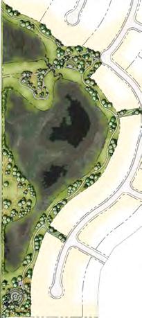
24 Section N o. 4 Plan Policies 4.1 Land Use Strategy Three principal land use policy areas have been identified within the Painted Sky Neighbourhood Plan. Requirements for land use redesignation and subdivision plans will vary according to the location, context, and policy goals of each land use policy area. Residential Neighbourhood Painted Sky is a distinct neighbourhood with a feature park as a focal point. In addition, there will be sub-neighbourhood parks and an interconnecting pathway system linking the school, the proposed gateway node and the existing community of Langdon. The intent is to create a neighbourhood which is identifiable, thereby providing a sense of belonging as well as clarity of orientation within the larger community. Architectural style, detailing of streetscapes, design of urban elements and landscaping are some of the elements which will be used to establish a unique identity for the neighbourhood. Parks and Open Space Painted Sky is designed to provide both active and passive recreation opportunities, to enhance pedestrian connectivity as well as to serve a visual and social function. A comprehensive system of neighbourhood, sub-neighbourhood and linear parks and pathways will provide connectivity within the community of Painted Sky and beyond. The open space system in Painted Sky will become a logical extension of the existing and developing open space network within Langdon. Neighbourhood and sub-neighbourhood parks are located in a manner that enhance social interaction as well as make a visual statement. The central neighbourhood park, the sub-neighbourhood parks and the interconnected linear park and pathway system all work together to achieve a balanced distribution of open space within the broader community. Two wetlands along Vale View Road are proposed to be retained with future adjacent development being designed to complement these natural features. Gateway Node The gateway entrance to Painted Sky from Glenmore Trail is envisioned as a neighbourhood scale commercial centre that provides opportunity for specific needs mixed-use housing, commercial services and other civic uses including emergency services that can both take advantage of the unique gateway location of the site and be integrated sensitively within the surrounding community. The gateway node will be linked with the surrounding residential neighbourhood, the proposed school site, wetland and parks, and the rest of Langdon through an interconnected pathway/sidewalk system. Housing Painted Sky will provide primarily single-family housing with the opportunity to accommodate a diversity of housing choices including small lot single-family housing, and alternate housing forms (i.e. townhouses, semi-detached as the market dictates). Lot sizes will vary and could include a variety of homes including townhouse, semi-detached or duplex products that face onto central common areas. Some larger outlying lots will be situated directly onto natural areas and water features. Market demand will dictate various forms of housing at the subdivision stage on a phased basis. Storm Water Retention Facility and Natural Wetlands A storm water retention facility and high valued wetlands will be integrated within the community which will also act as water features for the enjoyment of community residents. A stormpond has been strategically located in the southeast corner where it will provide the most efficient use of the stormwater infrastructure. Protection and preservation of existing wetlands along the western portion of the neighbourhood will be incorporated into the overall community design. Road Network The Painted Sky community design has been prepared to integrate with existing and future developments, including existing access conditions. The internal road network is typical of Langdon s existing grid pattern of roads, although lanes and some cul-de-sacs are proposed to address design constraints as well as to reduce the visual impact of smaller lot development. Connectivity with the existing Hamlet development to the east is addressed through a continuation of the grid pattern with controlled access. Pedestrian accessibility, however, is seamless and encouraged through the extensive use of sidewalks and connecting pathways. 19 PAINTED SKY IN LANGDON NEIGHBOURHOOD PLAN
25 Section N o. 4 Plan Policies Table 2 Primary Land Use Policy Areas Land Use Development Implementation Approach Residential Gateway Node Open Space, Park and School primarily single-detached housing multitude of lot sizes incorporation of multi-family medium density housing in the form of row housing (townhouse) semi-detached housing transition and buffering of land uses adjacent to other land use areas pedestrian-oriented mixed-use development including residential and local commercial emergency services local neighbourhood-serving uses specific needs housing opportunities (seniors) school site, playing fields, pathways, parks, community open space and natural areas recreational opportunities - both passive and active use walking, hiking, cycling, soccer, baseball, etc. municipal servicing for potable water and sewer comprehensive land use redesignations and subdivision plans linked park and pathway network providing connectivity between the gateway node, the school site, neighbourhoods, and the rest of Langdon maximize direct access to the open space and pathway system from all types of residential development local goods and services linked park and pathway network providing connectivity between the mixed use area, the school site, neighbourhoods, and the rest of Langdon appropriate range of medium density housing types stores fronting on sidewalks on-street angle and parallel parking sidewalk amenities, including patios, street furniture, public art, planters, ornamental street lighting coordination of roadways and pathways linked park and pathway network providing connectivity between the mixed use area, the school site, neighbourhoods, and the rest of the Langdon dedication of municipal and school reserves through subdivision process appropriate balance and integration of recreational uses appropriate balance and integration of landscaped and natural areas Each of these land use policy areas is subject to policies that will provide guidance in the preparation of land use redesignation and subdivision plans. The policies in this Neighbourhood Plan are intended to address an appropriate level of detail while also allowing for a reasonable degree of flexibility and innovation in design and development. QUALICO COMMUNITIES APRIL
26 Land Use Concept and Statistics The Painted Sky Neighbourhood Plan has been prepared to meet the Langdon ASP development criteria (Section 27). The Langdon ASP plans for an approximate population of 13,400. The anticipated number of dwellings and density are as shown below. Table 3 Land Use Statistics Frontage Areas Meters (m) Hectares (ha) Acres (ac) % TOTAL AREA ha ac LESS Environmental Reserve 5.54 ha ac Road Widening (Glenmore Trail) m 0.81 ha 2.00 ac Road Widening (Vale View Road) 7.94 m 1.09 ha 2.69 ac Gross Development Area ha ac 100.0% Gateway Node 4.96 ha ac 4.9% Municipal Reserve (Park) 5.70 ha ac 5.7% Municipal School Reserve (Park) 4.45 ha ac 4.4% Public Utility Lots (PUL) 4.23 ha ac 4.2% Residential Laned 4, m ha ac 15.0% Laneless 11, m ha ac 42.4% Total Frontage 15, m Local Roads Road Widening (Railway Avenue) 5.00 m 0.40 ha 0.99 ac 0.4% Internal Roads/Lanes ha ac 23.0% Interpretation: The above table has been included for convenience and purposes of determining expected density, population and housing type range. Final lot widths, housing type distribution, and lot counts will be determined at the subdivision stage in accordance with the residential policies of this local plan. 21 PAINTED SKY IN LANGDON NEIGHBOURHOOD PLAN
 Glenmore Trail Widening Glenmore Trail (HWY 560) Bishop Cres Gateway Node Glenmore Trail Widening Bishop Cres Besse Ave Gateway Node")
27 Section N o. 4 Plan Policies Figure 5 Concept Plan Glenmore Trail (HWY 560) Glenmore Trail Widening Glenmore Trail (HWY 560) Bishop Cres Gateway Node Glenmore Trail Widening Bishop Cres Besse Ave Gateway Node Besse Brander Ave Ave Vale View Road (RGE RD 273) Vale View Road (RGE RD 273) Vale View Road Widening Vale View Road Widening Wetland Wetland Wetland Wetland MSR MSR (School Site) (School Site) McKinnon St McKinnon St Brander Ave (By Others) (By Others) Railway Avenue (TWP RD 233A) Legend Railway Avenue (TWP RD 233A) Neighbourhood Plan Boundary Residential Legend Parks and School (MR / MSR) Neighbourhood Environmental Plan Reserve Boundary (ER) Residential Parks and School (MR / MSR) Environmental Reserve (ER) Apr 21, :30pm W:\911 Painted Sky\DWG\911-CS APRIL21.dwg Apr 21, :30pm W:\911 Painted Sky\DWG\911-CS APRIL21.dwg Storm Water Pond (PUL) Regional Drainage Ditch (PUL) Storm Water Pond (PUL) Regional Drainage Ditch (PUL) QUALICO COMMUNITIES APRIL 2017 NTS 22 Painted Sky Conceptual Scheme Figure Development NTS Concept
28 4.2 Residential Policy Painted Sky will have a distinct character and sense of place through its community design and built form. The purpose of the Residential Policy Area is to comprehensively plan for a new neighbourhood with rural character, an efficient development pattern, and provision of appropriate land use transitions to lands outside the plan area. The residential component of the Painted Sky Land Use Concept has been prepared to align with Map 5 and the policies contained within Section 8 of the Langdon ASP. The predominant housing anticipated within the residential area will be single detached residences. However semi-detached residences, and townhouses have been incorporated into the overall design to provide housing choice and additional variety. Residential Trends A market demand study was prepared by Altus Group Economic Consulting in the spring of 2016 in support of this land use concept. It is expected that Langdon will continue to represent a significant proportion of overall residential growth in the County and in particular the local trade area. Growth expectations for the life of this Neighbourhood Plan and the Langdon Area Structure Plan (10-20 Years) should see trends in growth occurring among young families with children and among older segments, both with preferences for single family housing and communities. Trends in population and demographics in the Calgary Region indicate that policies should be aimed at adding new housing supply providing for segments of the population in the move-up age range of (35-50) as well as the move-down range of 65+). Trends in Population and Demographics in the Calgary Region Population of the Langdon Trade Area - Expected Growth Rates Market Age Range Growth Potential Langdon Trade Area Value Focused first step housing % Next 5 Years ( ) Boomer-Echo / Early Millennial % Following 10 Years ( ) Boomer Generation % Following 15 Years ( ) Langdon Residential and Commercial Demand Projection (Altus Group, Q2 2016) Expected housing demand in both the Langdon trade area well as the Hamlet could be met by Painted Sky. 23 PAINTED SKY IN LANGDON NEIGHBOURHOOD PLAN
29 Section N o. 4 Plan Policies Residential Density and Population Estimates The Painted Sky development concept anticipates a maximum overall residential density of approximately 4.56 units per gross acre. Twenty percent (20%) of the housing product has been targeted at alternate housing options which will facilitate a variety of housing choice for new residents, and increase the affordability and diversity to the neighbourhood. This is in keeping with the policies of the current Langdon Area Structure Plan and the historical anticipated density expectations which had guided neighbouring development seen in Langdon Crossings West. Housing Type % of Units Anticipated Lot Width Width Range Area Range (ft 2 ) # of Units Dwelling, Single-detached (Single Family) 80% 15.25m (50ft) m (38ft) to 18.29m (60ft) 4,370 to 6, Dwelling, Single-Detached Pioneer Single Family 10% 10.52m (34.5 ft) 9.14m (30ft) to 11.58m (38ft) 3,450 to 4, Dwelling, Semi-detached 5% 8.4m (27.56 ft) 7.62m (25ft) to 8.84m (29ft) 2,875 to 3, Dwelling, Row Housing (Townhouse) 5% 6.86m (22.50 ft) 6.10m (20 ft) to 7.32m (24ft) 2,300 to 2, TOTAL 100% 1,133 DENSITY (UPA) 4.56 Units Per Acre Anticipated Population Housing Units Persons / Dwelling Anticipated Population (Langdon Area Structure Plan) 3512 Interpretation: The above table has been included for convenience and purposes of determining expected density, population and housing type range. Final lot widths, housing type distribution, and lot counts will be determined at the subdivision stage in accordance with the residential policies of this local plan. QUALICO COMMUNITIES APRIL

30 Residential Housing Type The purpose of the Residential Policy is to plan comprehensively for a community with rural character, an efficient development pattern, and to provide for appropriate land use transitions to lands outside the Neighbourhood Plan Area. The creation of a sense of identity is to be achieved through the proposed housing product and streetscapes anticipated for the neighbourhood. Painted Sky is envisioned to be a low-density, single-family community with limited medium density and alternate housing form that is sensitively integrated into the neighbourhood. Focus has been placed on street-oriented design that accommodates a variety of lot widths and home sizes. Painted Sky is designed to be compatible and integrated with the adjacent community development pattern through the use of controlled road access, pedestrian linkages (sidewalks and pathways), and a transition of lot sizes. The Concept Plan contemplates a larger lot interface with existing development to the east. Rendering of a potential streetscape in Painted Sky - Single Family FOR CONCEPTUAL PURPOSES ONLY 25 PAINTED SKY IN LANGDON NEIGHBOURHOOD PLAN
.")

 to 18.29m (60ft) wide lots available.")
31 Section N o. 4 Plan Policies SINGLE-FAMILY HOMES Residential development will be mainly single family homes provided on a range of lot sizes to accommodate a variety of housing product. Single-detached Dwelling (Large Lot). A variety of housing product and lot type is proposed throughout the neighbourhood, with a predominate focus on providing for the single-detached market which is expected to dominate in the Langdon area over the course of the current growth plan. Approximately 80% of the planned residential housing (± 913 homes) is anticipated to be in the form of large lot single family housing constructed on a variety of lot widths and sizes, with both laned and laneless lots options. Lot widths are anticipated to accommodate a greater selection of housing choice with 11.58m (38ft) to 18.29m (60ft) wide lots available. This range of lot size and dominance of single family housing will ensure consistency with the established housing pattern seen in the community today. Rendering of proposed single family housing typologies FOR CONCEPTUAL PURPOSES ONLY Boulevards along streetscapes to create an open feel FOR CONCEPTUAL PURPOSES ONLY Rendering of proposed single family residential FOR CONCEPTUAL PURPOSES ONLY QUALICO COMMUNITIES APRIL


32 Renderings of a potential single family residential streetscape in Painted Sky FOR CONCEPTUAL PURPOSES ONLY 27 PAINTED SKY IN LANGDON NEIGHBOURHOOD PLAN
33 Section N o. 4 Plan Policies ALTERNATE HOUSING TYPES An important part of the vision for Langdon in the next decade is to develop new neighbourhoods as predominately single detached homes while allowing opportunity for other housing types and density to be incorporated into a community design while respecting the existing built form of the community. Housing diversity to support a widening range of household type, income, and preference has been included into the neighbourhood vision for Painted Sky and includes a mixture of semi-detached dwellings (2 attached units), row housing or townhouses (3 or more attached units) and a value-focused housing product called Pioneer Single Family. These alternative housing styles will comprise approximately 20% of the overall housing product for Painted Sky. Single-Detached Dwelling (Pioneer). A portion of the anticipated single-family housing product will be devoted to the entry level market and 10% of the total housing product (± 108 homes) anticipated for Painted Sky will be of this type of housing. These smaller houses and lots will be directed towards laned lots which will accommodate rear detached garages and be planned in the same fashion as the required medium density guidelines for the community. Semi-Detached Dwellings. A limited amount of semidetached houses are anticipated to be located within the neighbourhood. It is anticipated that approximately 5% of the housing product (±56) will be aimed at this market. Semi-detached dwellings may be located along main traffic corridors to promote an alternative streetscape. Row Housing (Townhouse). Rounding out the housing product for Painted Sky will be devoting a portion of the planned laned lots for the development of row housing. Row housing or townhouse homes will be oriented to the street in a similar fashion as the pioneer single-family product and aimed at a similar market. Approximately 5% (± 56 homes) are anticipated. Specifically this townhouse product will be oriented towards the street with parking in the rear and located in proximity to planned community amenities such as parks, school and neighbourhood commercial areas. Policies General The predominant land use shall be low density residential in the form of single-detached dwellings located on a wide range of lot widths; Lot and block layouts shown on the Concept Plan are conceptual only and may not reflect the final design, number or size of lots that may be proposed in future tentative plans of subdivision. The final size, configuration and design of individual parcels proposed through subdivision shall be determined at the tentative subdivision plan approval stage and to the satisfaction of Rocky View County; At the time of subdivision, density for each phase will be calculated and monitored in comparison to the anticipated density and proportion of housing product indicated in this plan; The development concept should incorporate multi-family dwellings, neighbourhood parks, and a system of sidewalks, pathways, and roadways that provide connectivity with Langdon; A suitable range of housing types shall be allowed, provided such housing types are compatible with their surroundings and integrated in an efficient and logical manner. The type of housing product should be comprised of: a. single-detached dwelling (single family); b. single-detached dwelling (pioneer); c. semi-detached dwelling; d. row housing (townhouse); e. seniors housing; Where new residential areas are developed in proximity to developed residential areas, there shall be an acceptable transition between the two areas through appropriate building form similar in height, massing and architectural design; The development concept shall include locally appropriate prairie building styles and aesthetics; QUALICO COMMUNITIES APRIL


34 Rendering of a entranceway & open space in Painted Sky FOR CONCEPTUAL PURPOSES ONLY East entrance - faux-bridge rendering Rendering of pathway integration into Painted Sky FOR CONCEPTUAL PURPOSES ONLY FOR CONCEPTUAL PURPOSES ONLY 29 PAINTED SKY IN LANGDON NEIGHBOURHOOD PLAN
35 Section N o. 4 Plan Policies SENIORS HOUSING As the senior population in Langdon and the County increases in the coming years, opportunities for housing options with the Painted Sky neighbourhood could be realized. It is important that the future residents of Langdon and Painted Sky have the opportunity to remain within the community as they age and have a variety of housing options suited to their income level and required level of support and independence. The inclusion of the proposed alternate housing product will compliment the single detached dwellings and help facilitate a wider range of housing types that can promote aging at home, affordability and more supportive living options. ARCHITECTURAL GUIDELINES The architectural guidelines for Painted Sky are intended to reflect the prairie context and historical significance of Langdon. These guidelines will provide for a compatible variety of massing, colours and housing styles that will assist in achieving the overall vision for Painted Sky, that of a community that expresses and relates to the surrounding regional prairie context. Elements of prairie building styles and aesthetics that will serve as visual organizing principles are intended to be expressed through the use of rural based building form and massing, traditional building colors and materials. These guidelines may be revised from time to time to reflect market changes. Qualico is sensitive to its agricultural neighbours. As such, for lots adjacent to an agricultural operation, additional edge treatment should be considered and implemented through the architectural guidelines with guidance from the County s Agricultural Boundary Design Guidelines Architectural controls will be formulated and implemented by the developer in order to ensure aesthetically coordinated development in keeping with the prairie heritage architectural style and theme. Prairie heritage architectural design elements reflecting Langdon s history should be incorporated into building design; Lighting should conform to Dark Sky Principles and be designed in a manner sensitive to a rural country setting and may include different types of lighting (i.e. fixtures that direct light downward only) as well as reduced levels of lighting; The integration of meaningful neighbourhood gathering places for resident interaction shall include local parks, the natural environment, the potential future school site and a future mixed use area; Seniors housing, public, recreational, and institutional uses such as child care facilities are encouraged and have been included in the land use concept where appropriate; Lots adjacent to an agricultural operation should consider edge treatment such as incorporation of appropriate landscaping and fencing with guidance from the County s Agricultural Boundary Design Guidelines. Alternative Housing The development concept shall include lanes to accommodate the anticipated diversity of housing product, variety and interest to the street and facilitate street oriented design; The following proposed housing types shall be oriented to the street with parking located off a lane: a. Dwellings, Row Housing (Townhouse); b. Dwelling, Single Detached (Pioneer Single Family); Row Housing (Townhouses) should be located in proximity to community amenity areas such as local parks, the future school site, open space, institutional and local commercial uses; and The incorporation of single-detached housing (Pioneer Single Family) should be built on a minimum 9.14m (30ft) lot width. QUALICO COMMUNITIES APRIL
 and Vale View Road intersection will act as the primary entrance and arrival point for the community of Langdon.")

36 4.3 Gateway Node Painted Sky has the opportunity to take advantage of a primary gateway into the community of Langdon. The location of the planning area at the intersection of Glenmore Trail (HWY 566) and Vale View Road intersection will act as the primary entrance and arrival point for the community of Langdon. It is important that this gateway is visually attractive, wellmaintained and provides for an inviting destination. The Painted Sky development concept hopes to take advantage of this unique location and has been designed in accordance with the ASP policies and the Rocky View County Commercial, Office and Industrial Design Guidelines. Alberta Transportation has also been involved in the creation of this attractive gateway along its highway (Glenmore Trail). The purpose of the proposed Gateway Node is to provide a focal point for the Painted Sky neighbourhood and at the same time provide benefit to the overall community without detracting from the opportunities presented along Centre Street. This area is anticipated to be developed near the build-out of the Painted Sky as the last phase. Rendering of proposed fire hall at Gateway Rendering of proposed fire hall at Gateway 31 PAINTED SKY IN LANGDON NEIGHBOURHOOD PLAN 31
37 Section No. 4 Plan Policies Sketch Conceptualization of Proposed Gateway Area GLENM V E AL VI EW RO ORE TR A IL AD CONCEPTUAL DESIGN ONLY - FUTURE MARKET WILL DETERMINE FINAL USE AND DESIGN. QUALICO COMMUNITIES APRIL
38 The proposed Gateway Node aspires to create a centre focused on the neighbourhood. Primary design principles for the gateway has consideration for sight lines, noise attenuation, setbacks, natural land features, innovative building design, and high quality landscaping, signage and parking. Some primary design strategies that are envisioned are: Gateway Development. The future land use concept presented in the Langdon Area Structure Plan recognizes the strategic nature of this gateway and its role as an important entrance into the community which represents a community s welcome and stresses the importance that is becomes a visually attractive and well maintained development. Neighbourhood Commercial. The north-west portion of the planning area presents an ideal location to develop a neighbourhood focused destination that can support a wellintegrated, neighbourhood oriented commercial node located on the periphery of the neighbourhood along arterial and major collector roads. Civic Uses. The incorporation of civic mixed uses into the design concept for the gateway node that can complement surrounding residential, special needs housing (seniors, live/ work), and neighbourhood commercial. The opportunity for small-scale cultural facilities, religious assembly, community meeting space, civic offices or facilities that can foster a lively, walkable neighbourhood with a meaningful gathering place. Specific Needs Housing. To incorporate residential housing aimed at specific needs housing to address an aging population by integrating housing at walkable locations. Housing aimed at seniors is encouraged to be located within easy walking distance to neighbourhood commercial, services, and amenities. The opportunity for a flexible mix of land uses which include residential, neighbourhood commercial, institutional and civic focus. Emergency Services. As Langdon grows beyond the current population, increased demand on the provision of local emergency services will increase (police, fire, and ambulance). To ensure that these services have the opportunity to expand, the proposed gateway node and its strategic location along the Provincial and Local transportation network, can accommodate opportunity for the location of an emergency services facility at the corner of Glenmore Trail and Vale View Road. Policies General Small-scale neighbourhood commercial that serves the convenience needs of local residents should be encouraged and be well-integrated into the overall design; Specific Needs Housing that addresses needs of an aging population should be encouraged and located within easy walking distance to retail, services and amenities; Other related uses should be encouraged within the gateway node including medium density housing, live/work spaces, cultural facilities, community meeting space, places of worship, civic uses and facilities and other related uses; Built Form Policy Locate buildings or civic uses at the corner of main intersections to help facilitate a sense of place and presence; Integrate a unique civic plaza or green space within the gateway node to promote community interaction; Buildings should be oriented in such a way that the rear of the building does not face an adjacent property.; Parking and loading areas should be appropriately screened, or located so as not to be visible from adjacent areas; Consideration of highly articulated facades and landscaping should be incorporated into the overall design; and Roads and pathways should be coordinated with adjacent areas. 33 PAINTED SKY IN LANGDON NEIGHBOURHOOD PLAN

39 Section No. 4 Plan Policies A market demand study has been prepared by Altus Group Economic Consulting in the spring of 2016 in support of this land use concept and viability of commercial opportunity within the neighbourhood activity centre. Some of the key opportunities are discussed below: Commercial Opportunity. A neighbourhood shopping centre of approximately 40,000 ft2 could be developed as part of the later stages of the Painted Sky neighbourhood build out. Commercial Timing and Sensitivity to Centre Street Opportunities. The timing of such development would ensure no competition with the Centre Street area for at least the next ten years and would entail the capture of only a portion of the growth in retail demand from the trade area. Unique Commercial Opportunity. Development would differ from the Centre Street area in that vehicle accessibility and convenience will form a key part of shopping centre design as opposed to the Centre Street area that places priority on pedestrian movement and small-scale local commercial development. Gateway Commercial Opportunity. Targeted uses for commercial adjacent to Highway 560 would be directed towards transient traffic as well as serving the daily needs of Painted Sky neighbourhood. It would also become an attractive service node and gateway into the larger Langdon community. Destination Uses. Commercial uses will be primarily driven by market demand and may include a convenience store, pharmacy, personal service businesses (daycare or fitness facilities) restaurants and a gas station. Drive-through restaurants could specifically be targeted since no such facilities will be permitted on Centre Street. QUALICO COMMUNITIES APRIL
40 Figure 6 Commercial Nodes and Pedestrian Connections kj Painted Sky kj kj Langdon Crossings West Painted Sky Mornington kj kj kj!( S kj kj kj kj n Langdon Crossings West Mornington Langdon Station kj kj kj!(!( S S kj kj!( S Langdon kj kj n kj Meadows Langdon Station Boulder Creek Hanson Ranch Langdon Meadows kj Hanson Ranch kj Boulder Creek kj kj W:\911 Painted Sky\GIS\Maps\CommercialPedestrian8.5x11L.mxd Legend Sep 26, :17 PM W:\911 Painted Sky\GIS\Maps\CommercialPedestrian8.5x11L.mxd kj Commerical Node Park Developing Pedestrian Network Anticipated Commercial S Existing School Future Recreation Centre Existing Green Space kj!( kj Future School kj n Legend Fire Hall Subject Land kj kj Future School Commerical Node kj!( Park S Existing School kj Future Recreation Centre n Fire Hall 400m (5 min Walk) 800m (10 min Walk) Developing Pedestrian Network Anticipated Commercial Existing Green Space Painted Sky Conceptual Scheme Commercial Nodes & Pain Pedestrian Connections Conceptual 400m (5 min Walk) 800m (10 min Walk) Map and data for informational and planning purposes only. Commercia Pedestrian Con Map and data for informationa 35 PAINTED SKY IN LANGDON NEIGHBOURHOOD PLAN
 that is centrally located within the neighbourhood.")

41 Section N o. 4 Plan Policies 4.4 Schools Assessment Painted Sky has been designed to accommodate a future joint municipal and school reserve site (MSR) that is centrally located within the neighbourhood. The Langdon School Analysis & Pedestrian Connections figure shows the coverage of area within a 5 minute walking distance from the future school site. It also shows that virtually the entire Painted Sky neighbourhood is within a 10 minute walking distance. Langdon is very well served by schools and open spaces. Painted Sky will continue this coverage through provision of the MSR site and well connected pedestrian trails, pathways and/or sidewalks. Policies The Developer and the County shall collaborate with school authorities on school development; The location of the new school site is an important design element for the proposed neighbourhood. The amount of land dedicated for a future school site should be consistent with the size requirements delineated in the Reserves Agreement between Rocky View County and the School Authorities; The system of linked open spaces (joint use areas and pathways/trails/sidewalks) provided an important design element for the neighbourhood. This system of open space (open space / joint use) areas shall be maintained in subsequent applications for subdivision approval to the County; The school site should be designed and located on reserve land that is optimized for facilities and play areas; Photo courtesy of The Chestermere Anchor Weekly The school site and facilities should be configured in a manner satisfactory to the School Authorities and the County; The school site should be located on collector roads with appropriate consideration to parent drop off and school bus related traffic movements; The school site shall be situated to minimize hazards associated with student crossings of roads and mitigated through use of innovative design approaches to road design; and The school site shall be sensitively integrated into the proposed opens space and park network and shall ensure pedestrian movement is accommodated. QUALICO COMMUNITIES APRIL
42 Figure 7 Langdon School Analysis & Pedestrian Connections kj Painted Sky kj kj Langdon Crossings West Painted Sky Mornington kj kj kj!( S kj kj kj kj n Langdon Crossings West Mornington Langdon Station kj kj kj!(!( S S kj kj!( S Langdon kj kj n kj Meadows Langdon Station Boulder Creek Hanson Ranch Langdon Meadows kj Hanson Ranch kj Boulder Creek kj kj W:\911 Painted Sky\GIS\Maps\SchoolPedestrian8.5x11L.mxd Legend Sep 26, :15 PM W:\911 Painted Sky\GIS\Maps\SchoolPedestrian8.5x11L.mxd kj Commerical Node Park Developing Pedestrian Network Anticipated Commercial S Existing School Future Recreation Centre Existing Green Space kj!( kj Future School kj Legend n Fire Hall Subject Land kj kj Future School Commerical Node kj!( Park S Existing School kj Future Recreation Centre n Fire Hall 400m (5 min Walk) 800m (10 min Walk) Developing Pedestrian Network Anticipated Commercial Existing Green Space Painted Sky Conceptual Scheme School Analysis & Pain Pedestrian Connections Conceptual 400m (5 min Walk) 800m (10 min Walk) Map and data for informational and planning purposes only. School A Pedestrian Con Map and data for informationa 37 PAINTED SKY IN LANGDON NEIGHBOURHOOD PLAN

43 Section N o. 4 Plan Policies 4.5 Recreation, Cultural, and Community Uses Painted Sky includes a range of opportunities for culture, recreation and community uses including a future school and neighbourhood activity centre. The opportunity for live-work units and artist studios has been incorporated in order to foster a creative and entrepreneurial culture and sense of wellbeing. The gateway node is intended to facilitate a range of institutional and cultural facilities such as religious, educational, cultural and community organizations. Policies Connections to facilitate access for all modes of travel to the proposed Gateway Node, school site, environmental areas and park system shall be encouraged; Recreation, culture, institutional, and community uses shall be encouraged and integrated into the neighbourhood fabric in accordance with the recommendations of the Langdon ASP and County Plan; Community space for meetings, worship, art, performance and learning should be incorporated into the open space network or Gateway Node. and The incorporation of public art into community spaces and public infrastructure should be encouraged where the opportunity arises. QUALICO COMMUNITIES APRIL

44 4.6 Open Space, Parks, Pathways and Trails Painted Sky will consist of a comprehensive system of neighbourhood, sub-neighbourhood, and interconnected linear parks and pathways that will provide connectivity within the community, and will become a logical extension of the existing open space within Langdon. High quality landscaping that reflects the prairie landscape and historical significance of the area will be evident throughout the community, incorporating elements of prairie building styles and aesthetics. Appropriate considerations during subdivision design can assist in maintaining a safe environment. Examples include: where visual surveillance is fundamental, avoidance of linear spaces without public surveillance/access; proper placement of landscaping (shrub plantings, berming) in order to minimize potentially unsafe conditions; and the design of appropriate street lighting to create a sense of security during non-daylight hours. The Painted Sky Neighbourhood Plan provides for a series of parks and an interconnected pathway system that provides strong linkages to the gateway node, proposed school site and existing community. 39 PAINTED SKY IN LANGDON NEIGHBOURHOOD PLAN

45 Section N o. 4 Plan Policies The open space, parks, pathway, trail, and sidewalk network in this Conceptual Scheme is consistent with the network shown on Map 7 of the Langdon ASP. The purpose of the policies in this section is to provide for a comprehensive system of interconnected parks, pathways and open spaces. The Municipal Government Act allows a municipality to require that a landowner/ developer allocate and dedicate up to 10% of land at the time of subdivision for the purposes of providing public parks. Parks, open space and a school site will be provided as illustrated in the Open Space Plan. The plan accommodates over 10% of the plan area in parks, a school site, wetlands and storm water retention facility. In addition to storm water management, the associated areas will serve aesthetic, ecological and recreational functions within the community. The school site is located in a location that is central to the community, and therefore easily accessible by residents. East entrance - faux-bridge rendering QUALICO COMMUNITIES APRIL
 Glenmore Trail Widening 2 Bridge Crossing")
 Vale View Road (RGE")


 Storm Water Pond Separate Sidewalk Monowalk Connection Regional")


46 Figure 8 Open Space Plan Gateway Node Glenmore Trail (HWY 560) Glenmore Trail Widening Glenmore Trail (HWY 560) Glenmore Trail Widening 2 Bridge Crossing Required Bishop Cres Bridge Crossing Required Bishop Cres Besse Ave Gateway Node 2 1 Brander Ave Besse Ave Vale View Road (RGE RD 273) Vale View Road (RGE RD 273) Vale View Road Widening Vale View Road Widening 7 Wetland Wetland Wetland 7 Wetland McKinnon St McKinnon St Brander Ave (By Others) 8 Storm Water Pond 41 Legend Neighbourhood Plan Boundary Road Widening Legend Neighbourhood Plan Boundary Apr 21, :55pm W:\911 Painted Sky\DWG\911-CS APRIL21.dwg Road Widening Apr 21, :55pm W:\911 Painted Sky\DWG\911-CS APRIL21.dwg PAINTED SKY IN LANGDON NEIGHBOURHOOD PLAN (By Others) Railway Avenue (TWP RD 233A) Railway Avenue (TWP RD 233A) Storm Water Pond Separate Sidewalk Monowalk Connection Regional Pathway on South Side of Railway Avenue Local Pathway Separate Sidewalk Monowalk Connection Regional Pathway on South Side of Railway Avenue Local Pathway NTS Painted Sky Conceptual Scheme Figure 12A - Open Space NTS Plan Painted Sky Conceptual Scheme Portion of W 1 2 Section W4M Figure 12A - Open Space April Plan 2017 Portion of W 1 2 Section W4M
47 Section N o. 4 Plan Policies Open Space Features (see Appendix C for detail) 1] Painted Sky / Langdon Crossing West Gateway. The community gateway integrates the existing community of Langdon with the neighbourhood of Painted Sky. The proposed gateway, as a means of crossing the existing drainage corridor, allows the opportunity for a unique transition. The proposed concept illustrates a faux bridge crossing and integrates the regional pathway and sidewalk with new sidewalks and viewing opportunities while showcasing the naturalized drainage corridor. The enhanced crossing concept addresses the mid-block pathway crossing through a narrowed carriageway making pedestrian crossing safer. 2] North Neighbourhood Park. This park will provide passive and active recreation for the north part of the Painted Sky. The programing of the site allows for various recreational opportunities through a diversity of spaces. An enhanced plaza space with an overhead pergola and gateway will promote neighbourhood gatherings and celebrations, and is supported by an adjacent playground area, seating plaza with picnic and games tables and associated site furnishings. The requirements for bollards and site furnishing will be determined at the detailed design stage The central green and orchard will contribute to its uniqueness and sense of place. A bridging component provides connectivity in the far northeast corner of the plan to the existing pathway on the east side of the west ditch. 3] East Neighbourhood Park and Linear Connection. To take advantage of the existing pathway juncture, this proposed neighbourhood park will provide the pedestrian user not only with a contiguous access to the proposed future school site from existing Langdon, but a destination park for relaxation and play. A new regional pathway connection will occur across the drainage corridor allowing for pedestrian movement through the neighbourhoods. A naturalized interface with the drainage corridor including shrubs, trees and seating rocks will allow for a quiet place to sit. Picnic areas, a playground and informal open play spaces make this east neighbourhood park a hub for activity. The linear MR connection takes the regional pathway west to the future Municipal School Reserve site and its associated play fields. The mid-block crossing with a pedestrian safe-zone is designed in such a way to emphasize pedestrian movement and to ensure a safe crossing environment. Low growing grasses and public street art enhance the space providing a decorative element and bringing awareness to the site. QUALICO COMMUNITIES APRIL
48 4] School Site. This central open space area at +/ Ha (10.99 ac) in size will contain a school site and playfields (ball diamond and soccer pitch). With access to the site from four different streets, the site is easily accessible and is a functional amenity to the immediate community as well as to the adjacent Langdon neighbourhoods. Land forming on the site provides visual relief and potential winter (yearround) recreation. Park entry seating nodes are provided at access points as gathering spaces and as entrance transitions. The parcel configuration, street frontages and site grades are optimal for school and playfield development. 5] Central Park. At +/ Ha (2.27 ac) this neighbourhood park is the largest and most conducive for a diverse range of recreation opportunities throughout the year. Surrounded by residential development and in close proximity to the Gateway Node, the functional programming offers users many passive and active recreation opportunities. A playground facility, picnic areas, and a hard court for basketball and other court sports makes this park a destination year round. Land-forming is incorporated for visual relief and year round use. A large public plaza among a grove of trees offers passive recreation such as seating, games tables and an opportunity for public gatherings. This park will contribute to the vibrancy of the Painted Sky community. 6] South Neighbourhood Park. This south neighbourhood park will meet the needs of the southern area of Painted Sky. A central informal open space for active play is supported by a play-ground and associated picnic and seating areas. The Bosque on the west side of the park will provide a buffer and aid in wind protection and shade for park users through the summer season. Gentle land forming in the park provides visual relief and the trellis component provides architectural interest and a space for picnic and games tables. Lounge chairs and other park amenities such as bike racks and trash receptacles will be chosen to support the Painted Sky character and the enhanced public realm. Fencing along the common boundary with the laneway on the northern edge of the park will be required. 43 PAINTED SKY IN LANGDON NEIGHBOURHOOD PLAN Policies Parks and open space shall be addressed during all stages of development and ensure alignment with the County s Parks and Pathways: Planning, Development and Operational Guidelines as development references; That proposed pedestrian and open space network shall provide connections within, and external to, the Neighbourhood Plan area; The proposed open space and trails system shall be coordinated with the wetland and stormwater conveyance system; Incorporate principles of Crime Prevention Through Environmental Design (CPTED) features into the open space plan; Parks shall be designed so as not to create potential entrapment areas. This includes but is not limited to appropriate placement of landscaping materials (shrubs, trees, earth berms), minimizing long, narrow linear parks, and assuring proper lighting of all park spaces; The predominant land uses in the Open Space area shall be, outdoor passive and active recreational uses, wetlands, storm water retention, and school and educational programming; The parks, pathways, sidewalks and public open spaces shall provide recreational and travel opportunities and connections that will accommodate a variety of users and full accessibility (e.g., pedestrians, strollers, wheelchairs, bicycles) as determined appropriate by the developer and the Municipality; and Parks, pathways, sidewalks and public open space shall be designed, constructed, and wellmarked with signs to provide full accessibility and the safe and enjoyable use of those for whom they are intended (e.g., pedestrians, strollers, wheelchairs, bicycles, or the appropriate combination of such users).


49 Section N o. 4 Plan Policies Natural Park at the Western Wetland Bird Blinds Storm Pond Viewing Nodes Regional Pathway Granular Trail Amphitheatre Overland Drainage Connection East Neighbourhood Park Existing Local Pathway Informal Open Play Area Local Pathway Seating Picnic/Play Area Playground Possible Future Regional Pathway QUALICO COMMUNITIES APRIL


50 School Site and Adjacent Open Space Deciduous Trees Please refer to Appendix C on page 85 for fully detailed versions of all Open Space concepts Seating Node Play Fields Seating Node Central Park Pedestrian Plaza Hard Court Multi-sport Area Picnic Tables & Benches Terraced Hill Playground Picnic and Fitness Area Stations Informal Open Play Area Picnic Area 45 PAINTED SKY IN LANGDON NEIGHBOURHOOD PLAN
51 Section N o. 4 Plan Policies 7] Natural Park. The largest part of Painted Sky s open space system is comprised of the existing wetland system on the west side of the community. An Environmental Reserve (ER) buffer and Municipal Reserve (MR) is provided to make this area a key component to the open space system. Open space windows allow for public access to the system which also provide direct connections to the streetscape and other open space parcels. The regional pathway from the east moves through the ER/MR open space and ties to Vale View Road and the two streetscape collectors entering the community. This larger system supports both the need for a recreational component to the community, as well as respects the ecological component and habitat function of the area. A naturalized labyrinth is located at the northwest corner of the site which provides a whimsical element to the landscape for meditation or play. A large MR parcel compliments the natural open space system with land forming and increased vegetation for habitat and a buffer to the road. The southern portion of the park promotes education and interaction with the natural area with an outdoor classroom amphitheatre and seating/picnic opportunities with associated amenities. A small trail system allows nature lovers and bird enthusiasts to venture out into the natural area to take advantage of the proposed bird blinds and seating. Detailed design of park spaces will consider treatment of surfaces, setbacks and site furnishings. 8] Stormwater Pond. The southeast storm water pond and surrounding MR offer functional, recreation and visual benefits. From an open space perspective, a local pathway will provide recreational opportunity around the area and connectivity to adjacent streetscapes and the future pathway to the east. Benches and rock outcroppings offer various places to sit and relax with trees and native shrubs throughout the landscape. Note: Full accessibility implies functional use of the lands by users of all abilities including those who rely on or are dependent on the use of mobility aids. QUALICO COMMUNITIES APRIL
52 4.7 Natural Environment The proposed development concept has considered the long term conservation of valued wetlands and riparian areas through an extensive assessment throughout the plan preparation process. Wetland and associated riparian areas have been incorporated into the design of the neighbourhood and open space and parks system. A Wetlands Assessment and Biophysical Impact Assessment has been prepared and updated by Ecotone Environmental in August 2016 in support of the development concept. The majority of the site is cultivated or previously disturbed. The study identified that the proposed development will have minimal impact on regional habitat fragmentation, loss of wildlife corridor potential, and loss of regional biodiversity. Conservation of two wetlands will be achieved by considering pre-development water quantity, water fluctuation, water quality and ecological conditions. A buffer or setback around the wetlands will be reserved and enhanced with native vegetation in coordination with the design of the Municipal Reserve (MR). Integrating the re-vegetation of the setback areas with the design for the MR parcels, could allow for the incorporation of educational features and opportunities that can benefit the proposed school site, area residents, and visitors to the community. A review of all wetlands was conducted by Alberta Environment and Parks to determine if the wetlands were considered permanent and claimable under the Public Lands Act. None of the wetlands identified by Ecotone Environmental Ltd. were claimed by the Crown. Policies Conservation and effective management of riparian areas and wetlands should be in accordance with Provincial and County policy and guidelines; Riparian protection area should be guided by the Province of Alberta s Stepping Back from the Water Guidelines: A Beneficial Management Practices Guide for New Development near Water Bodies in Alberta s Settled Region; Source water protection strategies should be utilized where appropriate, in order to maintain source water quality and quantity for downstream users and the aquatic environment; Identified wetlands #27 and 33 shall be preserved and incorporated into the proposed development and open space concept in consultation with Alberta Environment; In order to mitigate impacts on rare plant populations associated with impacts to identified wetlands #4, 12 and 27, mitigation measures should be utilized to re-establish these species in consultation with Alberta Environment and Parks; In order to mitigate impacts on bird species at risk, construction activity should be limited to times outside of the peak breeding season (May-July) in compliance with the Migratory Bird Convention Act; Impacts on any of the identified wetlands shall require minimization and/or compensation of impacts and approval to construct shall be in accordance with Alberta Environment and Parks approvals under the Water Act; Wetlands shall be classified according to the Alberta Wetland Classification System to the satisfaction of Alberta Environment and Parks; Value of the wetlands shall be established based on the Alberta Wetland Rapid Evaluation Tool Actual (ABWRET-A) Manual to the satisfaction of Alberta Environment and Parks; Wetland compensation / mitigation proposal shall be based on the Alberta Wetland Mitigation Directive to the satisfaction of Alberta Environment and Parks; and Water Act approvals shall be required after the completion of the Wetland classifications, value assessments and compensation / mitigation proposal has been accepted by Alberta Environment and Parks. 47 PAINTED SKY IN LANGDON NEIGHBOURHOOD PLAN

.")
53 Section N o. 4 Plan Policies 4.8 Reserve Analysis A reserve analysis has been prepared to determine the amount, type, and use of reserves owing within Painted Sky. Areas to be dedicated ER, MR and MSR are shown on Figure 5. Concept Plan. The amount of land to be provided for municipal reserve will be equal to 10% of the Net Developable Area of the titled parcel(s) in accordance with Section 666 of the Municipal Government Act. MR can be a land dedication or can be paid as cash-in-lieu to Rocky View County. The Total MR and MSR dedicated is /- acres (+/ hectares). The balance of the MR and MSR owing will be paid as cash-in-lieu. Table 4 Reserve Analysis Policies Municipal and Environmental Reserve shall be provided as per the Reserve Analysis, and confirmed at the time of Subdivision; Multi-purpose and joint use parks and recreation facilities will be encouraged wherever possible; and Municipal Reserve (MR) and Municipal School Reserve MSR) shall be dedicated and the balance owing paid as cash-in-lieu to Rocky View County as determined at the subdivision stage to the satisfaction of Rocky View County. +/- ac +/- ha Gross Developable Area (GDA) Less Environmental Reserve (ER) Net Developable Area (NDA) MR Outstanding (@ 10%) MR Dedicated MSR Dedicated Total Dedicated (MR & MSR) Balance (to paid as cash-in-lieu) MR remaining (10%) QUALICO COMMUNITIES APRIL

54 4.9 Emergency Services The Painted Sky land use concept has addressed fire and protection (police) response measures and on-site firefighting requirements through consideration of such factors as efficient road design, safe and efficient access for emergency service vehicles, wildland fire protection, and fire control measures. The Hamlet of Langdon is served by a volunteer fire department located within the Hamlet. This fire department will be the primary response for the Plan Area. Police services are provided by the emergency dispatch center in Calgary (911). Rocky View County Peace Officers enforce selected government acts and municipal bylaws. Emergency Response is dispatched through the local volunteer Fire Department in Langdon. The fire station is located at Railway Avenue and east of Centre Street. of Calgary. The Plan area is located within minutes of two major hospitals, namely the Peter Lougheed Centre and the South Health Campus. Policies Crime Prevention Through Environmental Design features should be considered and incorporated into the design and construction of all new development, wherever possible; and At the subdivision stage, water supply for fire suppression purposes must be provided. These emergencies are directed to medical facilities in the City Conceptual rendering of proposed Langdon Fire Hall 49 PAINTED SKY IN LANGDON NEIGHBOURHOOD PLAN
55 Section No. 4 Plan Policies Sketch Conceptualization of Proposed Emergency Services GLENMO R E T R A IL CONCEPTUAL DESIGN ONLY - FUTURE MARKET WILL DETERMINE FINAL USE AND DESIGN. QUALICO COMMUNITIES APRIL
56 4.10 Transportation The regional transportation system has been developed in general accordance with Map 8 of the Langdon ASP. The classifications of the grid road network have been refined through further transportation analysis. Where required, Painted Sky accommodated existing and / or potential changes in access to the provincial transportation network, as identified on Map 8 of the Langdon ASP. The designation and design of local roads within the transportation network, including classification, street sizing, and intersection / access spacing, were determined during the preparation of Painted Sky. A Traffic Impact Assessment was prepared by Bunt and Associates in July 2016 to accompany the Painted Sky Local Plan in alignment with the Langdon ASP. Regional Transportation Network Access to the Painted Sky development will be from Vale View Road, Railway Avenue and Brander Avenue. Direct connections are provided between neighbouring residential areas and key destinations such as Centre Street and existing and planned schools within Langdon Presently, Vale View Road and Railway Avenue are classified as Regional Low Volume Roads (As noted in the Langdon Network Analysis, prepared February 23, 2016, by Watt Consulting Group). Based on the results of the Langdon Network Analysis, Watt Consulting has recommended that: 1] Railway Avenue be upgraded from Centre Street to Vale View Road to an Urban Residential Collector (with protection for a 27m Right-of-Way) prior to the 2020 Horizon. 2] Vale View Road is also recommend to be upgraded to a 2-Lane Regional Arterial Roadway, with a 30m Right-of- Way, prior to the 2020 Horizon. A Transportation Impact Assessment was prepared for the Painted Sky development by Bunt & Associates in July, The primary objectives of this study was to determine: Expected site generated traffic volumes for the proposed uses at 2020, 2030 and 2040 horizons based on the Institute of Transportation Engineers (ITE) Manual. Assign expected site generated traffic volumes to the road network based on anticipated site traffic distribution. Complete capacity analysis for post-development horizons during AM and PM peak hours at the following intersections: Highway 797 (Centre Street North) / Highway 560 Centre Street North / Brander Avenue Centre Street North / Railway Avenue (Township Road 233A) Vale View Road / Railway Avenue Vale View Road / Highway 560 Access points onto Vale View Road and Railway Avenue The key recommendations provided by Bunt are as follows: Intersections: All intersection noted in the Langdon Network Analysis will operate at optimal conditions and no improvements will be required at the 5 year horizon Intersection of Centre Street / Railway Avenue will require an independent northbound left turn lane. Intersection to function optimally as an all-stop controlled intersection Intersection of Centre Street / Brander Avenue will require an independent northbound left turn lane. Intersection to function optimally as an all-stop controlled intersection All intersections noted in the Langdon Network Analysis will operate at optimal conditions and no improvements will be required. 51 PAINTED SKY IN LANGDON NEIGHBOURHOOD PLAN
57 Vale View Road/ 797 Centre Street/ Hwy 560 Upgraded to 2-lane Regional Hwy 560 Requires an independent Arterial Roadway (30m ROW) northbound left turn lane b prior to 2024 Section All-stop N o. 4 Plan controlled Policies interse Upgraded to 2-lane Regional Requires an independent Glenmore Trail (HWY 560) Arterial Roadway (30m ROW) northbound left turn lane by TWP RD 234 prior to 2024 All-stop controlled intersection. Glenmore Trail (HWY 560) TWP RD 234 Regional Low Volume Road Figure 9 Regional Brander Transportation Avenue Plan Off-Site Anderson Improvements Avenue NW SW Regional Low Vale View Road (RGE RD 273) Volume Road Vale View Road (RGE RD 273) Regional Low Volume Road Regional Low Volume Road Vale View Road/ Railway Avenue Vale View Road/ Hwy 560 Upgraded to 2-lane Regional Arterial Roadway (30m ROW) prior to 2024 NW SW Regional Low Volume Road NW SW Glenmore Trail (HWY 560) Regional Low Volume Road Railway Avenue (TWP RD 233A) Centre Street Brander Avenue Railway Avenue (TWP RD 233A) Brander Avenue Centre Street Avenue 4 Street Railway Avenue (TWP RD 233A) Upgraded to an Urban Residential Collector (27m ROW) prior to 2024 Upgraded to an Urban Residential Collector (27m ROW) prior to 2024 Vale View Road/ Railway Avenue Anderson Avenue 2 Avenue Centre Street/ Hwy Street Centre Street Hamlet of Langdon Requires an independent northbound left turn lane by All-stop controlled intersection. TWP RD 234 Hamlet of Langdon Anderson Avenue 2 Avenue 4 Street Dead Horse Road (TWP RD 233) Requires an independent northbound left turn lane by All-stop controlled intersection. Hamlet of Langdon Requires an independent northbound left turn lane b All-stop controlled interse Requires an independent northbound left turn lane by All-stop controlled Dead Horse intersection. Road (TWP RD 233) Upgraded to an Urban Residential Collector (27m ROW) prior to 2024 Dead Horse Road (TWP RD 233) Vale View Road/ Railway Avenue TWP RD 232 TWP RD 232 Oct 27, :24am W:\911 Painted Sky\DWG\911-CS OCT27.dwg Legend TWP RD 232 Neighbourhood Plan Boundary 1:24am W:\911 Painted Sky\DWG\911-CS OCT27.dwg Hamlet of Langdon Boundary Highway/ Provincial Road Legend Regional Arterial (400.12) - 2 Lane Neighbourhood Plan Boundary Urban Primary Collector (400.3) - 2 Lane Oct 27, :24am W:\911 Painted Sky\DWG\911-CS OCT27.dwg Hamlet of Langdon Boundary Urban Residential Collector (400.2) - 2 Lane Highway/ Provincial Road Legend Regional Low Volum Road (400.8) - 2 Lane Regional Arterial (400.12) - 2 Neighbourhood Lane Plan Boundary Urban Primary Collector (400.3) Hamlet - 2 of Lane Langdon Boundary Highway/ Provincial Road Urban Residential Collector (400.2) - 2 Lane Regional Arterial (400.12) - 2 Lane Regional Low Volum Road (400.8) Urban Primary - 2 Lane Collector (400.3) - 2 Lane Urban Residential Collector (400.2) - 2 Lane Regional Low Volum Road (400.8) - 2 Lane Painted Sky Conceptu NTS NTS Figure Regional Transp Off-Site, Im Painted Sky Conceptual Scheme Figure Regional Transportation Plan Painted Sky Conceptual Off-Site, Improvements Scheme Portion of W 1 2 S Figure Regional Transportation Plan Off-Site, Portion Improvements of W 2 1 Section W4M QUALICO COMMUNITIES APRIL September 2017 Portion of W Section W4M September 2016

58 Internal Road Network The internal road network for the proposed Painted Sky development shall consist of core collector standard, urban residential roadways and paved lanes. Collector roadways will be designed with separate sidewalks on both sides of the street, linking the internal sidewalk and pathway network to municipal reserve lots, the future school site and to the regional pathway network. Boulevards along the collector roadways will be landscaped and planted to maximize the pedestrian experience. Residential streets will be constructed with monolithic sidewalk on one side of the street. Painted Sky will be serviced by two east / west collector roadways and one north / south urban collector roadway. There will be two transportation connections to each of Vale View Road and Railway Avenue. Roundabouts and other measures as seen in existing development to the east, will be incorporated to provide traffic calming. Roundabouts will be constructed at the intersection of the collector roadways to improve the efficiency of these intersections and movement of traffic while slowing traffic through the neighbourhood. Rendering of typical street proposed for Painted Sky Policies General A Transportation Impact Assessment may be required as part of the subdivision application for each phase if deemed necessary; A Transportation Impact Assessment may be required for the Gateway Node proposed in Phase 10 if deemed necessary; Collaboration with the Province regarding regional road connections and access to Highway 560 shall occur at each phase of subdivision and Alberta Transportation shall be circulated for comment; The proposed transportation network shall be designed to support an interconnected road and pedestrian system and promote a range of travel options; Roads, pathways, and trails shall connect adjacent neighbourhoods and accommodate a range of users, including pedestrians, cyclists and vehicles; The proposed transportation networks shall encourage alternative forms of transportation and be comprised of roads, sidewalks, pathways and trails; The road classification and layout may be refined through further transportation analysis at the time of subdivision application. Minor changes or modifications will not require an amendment to this Neighbourhood Plan; Regional Transportation Network Development shall provide required road rightsof-way and road widenings in collaboration with Alberta Transportation and Rocky View County and shall be dedicated in Phase 1; 53 PAINTED SKY IN LANGDON NEIGHBOURHOOD PLAN
59 Section N o. 4 Plan Policies Figure 10 Transportation Plan Glenmore Trail (HWY 560) Glenmore Trail (HWY 560) Glenmore Trail Widening Glenmore Trail Widening Bishop Cres Bishop Cres Gateway Node Gateway Node Besse Ave Besse Ave Brander Ave Brander Ave Vale View Road (RGE RD 273) Vale View Road (RGE RD 273) Vale View Road Widening Vale View Road Widening Wetland Wetland Wetland Wetland School School McKinnon St McKinnon St Potential Potential Linkage Linkage (Final Location TBD) (Final Location TBD) (By Others) (By Others) Storm Storm Water Pond Water Pond Railway Avenue (TWP RD 233A) Railway Avenue (TWP RD 233A) Legend Legend Neighbourhood Plan Boundary Neighbourhood Plan Boundary Urban Residential (9.0m/15.0m R/W) Urban Residential (9.0m/15.0m R/W) Country Collector (8.0m/25.0m R/W) Country Road Collector Widening (8.0m/25.0m R/W) Road Widening Apr 21, :38pm W:\911 Painted Sky\DWG\911-CS APRIL21.dwg Apr 21, :38pm W:\911 Painted Sky\DWG\911-CS APRIL21.dwg Core Collector (10.6m/21.0m R/W) Core Collector (10.6m/21.0m R/W) Regional Arterial (10.0m/36.0m R/W) Regional Arterial (10.0m/36.0m R/W) Key Access Points Key Access Points Potential Future Linkage (TBD) Potential Future Linkage (TBD) NTS NTS Painted Sky Conceptual Scheme Painted Sky Conceptual Scheme Figure QUALICO 9.0 COMMUNITIES - Transportation APRIL 2017 Plan Figure Transportation Plan54 Portion of W 2 1 Section W4M Portion of W 2 1 Section W4M April 2017

60 All boundary roadway and future intersection upgrades shall be designed in conformance with Rocky View County and Alberta Transportation design guidelines; Noise Impact/Attenuation studies may be required at the time of subdivision and/or development permit for lands adjacent to and south of Highway 560 in order to determine if and when an interface treatment between adjacent lands and the roadway is required All boundary roadways shall be designed in conformance with the recommendations contained within the Langdon Network Analysis; All applicable transportation off-site levies shall be collected upon endorsement of each phase of subdivision; Agreements respecting oversize improvements (cost sharing / endeavour to assist) will be considered in collaboration with the County to ensure any benefiting or excess capacity resulting from required infrastructure improvements is appropriately compensated; Internal Road Network Vale View Road should be developed as a regional arterial road for industrial use to encourage the separation of residential, commercial, and industrial traffic; a. Prior to the approval of the subdivision application of Phase 5 by the Subdivision Authority, the proposed connection with the Mornington neighbourhood should be reviewed to determine if it is required; Internal collector roadways should be designed and constructed to a Neighbourhood Core Collector Standard. (RVC Servicing Standard 800.7) A modified cross section for this roadway will be submitted by the developer to allow for a 21.0m Right-of-way; Residential streets should be designed and constructed to an Urban Residential standard, (RVC Servicing Standard 400.1); All internal roadways shall be designed and constructed in accordance with Rocky View County Servicing Standards; Alternative standards shall be considered for internal roadway systems, provided they are coordinated with and, where necessary, separated from parks, pathways, bicycle trails, natural areas, and residential development in a safe, efficient, and logical manner; Roadside signage and street lighting shall meet or exceed minimum Rocky View County Servicing Standards and shall be compatible with the character of the community The proposed internal road network should facilitate connectivity within and between the adjacent neighbourhoods of Langdon Crossings West and Mornington; Further consultation with the developer of the planned neighbourhood of Mornington should occur respecting transportation connections for multi-use transportation options (ie. Pedestrian, Cycle and Vehicle); 55 PAINTED SKY IN LANGDON NEIGHBOURHOOD PLAN
 Glenmore Trail Widening Glenmore Trail (HWY 560) Bishop Cres Gateway Node Glenmore Trail Widening Bishop Cres Besse Ave")
61 Section N o. 4 Plan Policies Figure 11 Pedestrian Circulation Glenmore Trail (HWY 560) Glenmore Trail Widening Glenmore Trail (HWY 560) Bishop Cres Gateway Node Glenmore Trail Widening Bishop Cres Besse Ave Gateway Node Besse Brander Ave Ave Vale View Road (RGE RD 273) Vale View Road (RGE RD 273) Vale View Road Widening Vale View Road Widening Wetland Wetland Wetland Wetland School School McKinnon St McKinnon St Brander Ave (By Others) Storm Water Pond (By Others) Railway Avenue (TWP RD 233A) Storm Water Pond Railway Avenue (TWP RD 233A) Legend Neighbourhood Plan Boundary Legend Road Widening Apr 21, :58pm W:\911 Painted Sky\DWG\911-CS APRIL21.dwg Neighbourhood Plan Boundary Road Widening Monowalk Apr 21, :58pm W:\911 Painted Sky\DWG\911-CS APRIL21.dwg Separate Sidewalk Monowalk NTS Separate Sidewalk Painted Sky Conceptual Scheme Figure Pedestrian Circulation NTS Painted Sky Conceptual Scheme QUALICO COMMUNITIES Portion of W 2 1 Section APRIL W4M 2017 Figure Pedestrian Circulation April Portion of W 1 2 Section W4M
62 Figure 12 Collector Cross Sections for Local Roadway 57 PAINTED SKY IN LANGDON NEIGHBOURHOOD PLAN

63 Section N o. 4 Plan Policies Figure 13 Collector Cross Sections for Brander Avenue The difference between the two cross sections is found within the width of the boulevard. The boulevard is narrowed to 2.40m from 2.90m. This difference of 0.50m is transferred into the optional separate sidewalk, to ensure the overall ROW of 21.00m is met. The optional separate sidewalk is expanded from 1.50m to 2.00m. This expansion will give pedestrians greater mobility throughout Painted Sky and will encourage increased usage. QUALICO COMMUNITIES APRIL
64 4.11 Utility Services Utility Infrastructure has been planned to support the proposed land use concept in order to provide essential services to the future residents within the Painted Sky neighbourhood. Utilities will be provided in an efficient and cost-effective manner, through logical extension of existing services. The general location and size of utility rights-of-way, and line assignments, have been determined through the preparation of Painted Sky to the mutual satisfaction of the County, the developer, and franchise utilities (natural gas, electricity, telecommunications). Shallow Utilities Painted Sky will be fully serviced at each phase with shallow utilities (natural gas, electricity, and telecommunications). Expansion and connection to each utility will be provided by extensions to existing services in the area. Potable Water Supply A Water Use Assessment has been prepared by BSEI to determine water demand and infrastructure requirements. Water supply systems for the Hamlet of Langdon all access groundwater sources for potable water. Components of the water distribution system include groundwater supply wells, a treatment facility, pumps for distribution and fire flow, and conventional piping, valves and hydrants. Water supply has been confirmed with Langdon Waterworks to service this development and provision of services will be verified with application for each phase of subdivision. Provision of water to each phase will be planned in association with Langdon Waterworks infrastructure projections and the staged upgrading of their water treatment plant and distribution system. The current water supply system has sufficient capacity to service the required demand anticipated for the initial phases of development. Section of the Langdon Infrastructure Report (Sim-Flo Systems Inc. April 5, 2015) identified staged upgrades for the water treatment plant to meet the future growth projected for the servicing area. With the completion the Stage 1 upgrade, Langdon Waterworks will be able to service the entire Painted Sky development. Two primary connection points to the existing Langdon network is planned, with the installation of a 300mm water main that will create an internal grid main network. One connection will be located at the west end of Brander Avenue. The second connection will be adjacent to the West Wastewater Lift Station, north of Railway Avenue and west of Cowan Street. Minimum Projected Average Day water Demand of 950L/day/unit. Water use projections for the proposed Painted Sky development are approximately 458,000m3/year. 59 PAINTED SKY IN LANGDON NEIGHBOURHOOD PLAN
 NW22 23-27-4 Figure 14 Regional Water & Sanitary Servicing SW22 23-27-4 Vale View Road (RGE RD 273) NW22 23-27-4 ailway Avenue (TWP RD 233A) Brander Avenue")
 Water Treatment Plant Wastewater Treatment Plant Hamlet of Langdon Dead Horse Road (TWP")
65 Section N o. 4 Plan Policies Glenmore Trail (HWY 560) NW Figure 14 Regional Water & Sanitary Servicing SW Vale View Road (RGE RD 273) NW ailway Avenue (TWP RD 233A) Brander Avenue SW Glenmore Trail (HWY 560) Cowan Street West Wastewater Lift Station Centre Street Railway Avenue (TWP RD 233A) Brander Avenue Cowan Street West Wastewater Lift Station Anderson Avenue 2 Avenue 4 Street Hamlet of Langdon Centre Street Anderson Avenue 2 Avenue 4 Street Dead Horse Road (TWP RD 233) Water Treatment Plant Wastewater Treatment Plant Hamlet of Langdon Dead Horse Road (TWP RD 233) Water Treatment Plant Wastewater Treatment Plant TWP RD 232 W:\911 Painted Sky\DWG\911-CS OCT27.dwg Legend Neighbourhood Plan Boundary Hamlet of Langdon Boundary Wastewater Transmission Main 300mm Water MainTWP RD 232 NTS Painted Sky Conceptual Scheme Figure Regional Water & Sanitary Servicing Portion of W 2 1 Section W4M September 2016 Oct 27, :26am W:\911 Painted Sky\DWG\911-CS OCT27.dwg Legend Neighbourhood Plan Boundary Hamlet of Langdon Boundary Wastewater Transmission Main NTS Painted Sky Conceptual Scheme QUALICO COMMUNITIES APRIL 2017 Figure Regional Water 60 & Sanitary Servicing Portion of W 2 1 Section W4M
66 Figure 15 Water Servicing Plan Glenmore Trail (HWY 560) Glenmore Trail (HWY 560) Glenmore Trail Widening Bishop Cres Gateway Node Gateway Node FUTURE CONNECTION Glenmore Trail Widening 300mm WATER LINE 300mm WATER LINE CONNECT TO EXISTING 300mm WATER AT BRANDER AVE CONNECT TO EXISTING 300mm WATER AT BRANDER AVE Bishop Cres Besse Ave Besse Ave Brander Ave Brander Ave Vale View Road (RGE RD 273) Vale View Road (RGE RD 273) Vale View Road Widening Vale View Road Widening FUTURE CONNECTION Wetland Wetland Wetland Wetland FUTURE FUTURE CONNECTION CONNECTION School School McKinnon St McKinnon St Cowan St Cowan St (By Others) (By Others) Railway Avenue (TWP RD 233A) Railway Avenue (TWP RD 233A) Storm Water Pond Storm Water Pond CONNECT TO EXISTING 300mm WATER AT COWAN STREET CONNECT TO EXISTING 300mm WATER AT COWAN STREET Legend 61 Legend Neighbourhood Plan Boundary Road Widening Neighbourhood Plan Boundary Road Proposed Widening W300mm PVC Proposed W300mm PVC Apr 21, :39pm W:\911 Painted Sky\DWG\911-CS APRIL21.dwg Apr 21, :39pm W:\911 Painted Sky\DWG\911-CS APRIL21.dwg BSEI Since 1977 Municipal Consulting Engineers BSEI Since 1977 Municipal Consulting Engineers PAINTED SKY IN LANGDON NEIGHBOURHOOD PLAN Proposed Water Distribution System (Various Sizes) Proposed Connection Water Distribution System (Various Sizes) Connection NTS Painted Sky Conceptual Scheme NTS Figure Water Servicing Plan Painted Sky Conceptual Scheme Figure Water Servicing Plan Portion of W 2 1 Section W4M April 2017 Portion of W 2 1 Section W4M
67 Section N o. 4 Plan Policies Wastewater / Sanitary Sewers Wastewater servicing for the Langdon occurs by way of a wastewater sewage collection system and wastewater treatment facilities owned and operated by Rocky View County. The existing west sanitary lift station currently services the west side of Langdon. It was anticipated that the lift station was adequate to accommodate Painted Sky. Analysis of the west lift station, however, has determined that it is currently being utilized to its maximum capacity and cannot be upgraded to service the Painted Sky development. convey the wastewater flow via force main to the 600mm force main that connects Balzac to the Langdon Wastewater Treatment Facilities with ultimate discharge of treated effluent being released into the Weed Lake wetland. As growth continues within the community, upgrading of the existing wastewater facilities will be required. A Wastewater Servicing Study has been provided by BSEI Engineering to determine wastewater demand and infrastructure requirements. Consequently, wastewater generated by the Painted Sky development will be conveyed via gravity to a proposed new wastewater lift station located adjacent to the storm pond in the southeast portion of the plan area. The proposed lift station will Minimum Projected Average Day Wastewater Flows of 855L/ day/unit Average Day Weather Flow (ADWF) of 13.10L/s, or 1,130m3/day Infiltration rate of 0.28L/s/ha Peak Wet Weather Flow (PWWF) for the Painted Sky project is 71.48L/s Water Conservation Langdon Waterworks philosophy is to consider water as a precious and important resource and one that should be used as sparingly and as efficiently as possible. Proper water stewardship benefits the environment in many ways; including reduced sewage treatment and disposal needs and costs, an increase to servicing capacity, reduction of energy and chemical costs, and the reduction of wasting water in general. This respect for water has been incorporated into the design of the Painted Sky neighbourhood. As a part of the EQWell program, all new residential and business construction will have dual-flush toilets and low flow fixtures. This aids in the reduction of potable water demands daily, and ensures that less water is wasted. Water conservation methods will be incorporated into the design of the water distribution and delivery to new construction and homes within the development. QUALICO COMMUNITIES APRIL
68 Figure 16 Sanitary Plan Glenmore Trail (HWY 560) Glenmore Trail (HWY 560) Glenmore Trail Widening Bishop Cres Gateway Node Gateway Node Glenmore Trail Widening Bishop Cres Besse Ave Besse Ave Brander Ave Brander Ave Vale View Road (RGE RD 273) Vale View Road (RGE RD 273) Vale View Road Widening Vale View Road Widening Wetland Wetland Wetland Wetland School School McKinnon St McKinnon St 63 Legend Legend Neighbourhood Plan Boundary Road Widening Neighbourhood Plan Boundary Road Proposed Widening 300mm Forcemain Proposed Existing 300mm 600mm Forcemain Forcemain Existing 600mm Forcemain Apr 21, :41pm W:\911 Painted Sky\DWG\911-CS APRIL21.dwg Apr 21, :41pm W:\911 Painted Sky\DWG\911-CS APRIL21.dwg BSEI Since 1977 Municipal Consulting Engineers BSEI Since 1977 Municipal Consulting Engineers PAINTED SKY IN LANGDON NEIGHBOURHOOD PLAN (By Others) Railway Avenue (TWP RD 233A) Railway Avenue (TWP RD 233A) CONNECT TO EXISTING 600mm FORCEMAIN TO LANGDON WASTEWATER TREATMENT PLANT Storm Water Pond WASTEWATER LIFT STATION Wastewater Potential Future Collection Connection Mains (Gravity & Various Sizes) Potential Lift Station Future Connection Lift Station (By Others) CONNECT TO EXISTING 600mm FORCEMAIN TO LANGDON WASTEWATER TREATMENT PLANT Storm Water Pond WASTEWATER LIFT STATION Wastewater Collection Mains (Gravity & Various Sizes) NTS Painted Sky Conceptual Scheme NTS Figure 11 - Sanitary Servicing Plan Painted Sky Conceptual Scheme Figure 11 - Sanitary Servicing Plan Portion of W 2 1 Section W4M April 2017 Portion of W 2 1 Section W4M
69 Policies Section N o. 4 Plan Policies General The County shall determine servicing wastewater capacity requirements and allocation within and external to Langdon Potable water and wastewater systems are to be provided in a safe, cost-effective, and fiscally sustainable manner; The County and the water supplier shall determine potable water capacity requirements and allocation within the Langdon; Painted Sky will abide by current and future water conservation practices and methods; Utility rights-of-way and easements shall be provided to accommodate County and potable water utilities and shallow utilities at the subdivision or development permit state, as deemed necessary; The costs to extend all required utility infrastructure as well as offsite costs deemed necessary by the County to serve the proposed development, shall be the responsibility of the developer; Cost recovery for utility oversizing as required by Rocky View County will be negotiated and any benefiting users and/or landowners will be required to share in construction and operating costs; All submissions shall be circulated to Alberta Environment and Parks for review and comment in accordance with the Standards and Guidelines for Municipal Waterworks, Wastewater and Storm Drainage Systems; Shallow Utilities Each phase of the development shall be fully serviced with private shallow utility systems such as electrical, natural gas, and telecommunications; Locations for easements and line assignments for shallow utility extensions shall be determined at the subdivision endorsement stage; Water A Water Use Assessment shall be reviewed with subdivision applications, and / or development permit applications to determine water demand and infrastructure requirements in order to confirm that sufficient potable water is available to service the proposed development; The detailed design for the Painted Sky water distribution system, on a per phase bases, shall be completed in accordance with the current Rocky View County Servicing Standards, and all applicable provincial guidelines; Applications for subdivision and development should include design elements that facilitate fire prevention methods and accessibility by emergency response vehicles for the suppression of fire, and the enhancement of police protection including, but not limited to, adequate site access and property identification; Wastewater The Wastewater Servicing Study shall be reviewed and updated to determine wastewater demand and infrastructure requirements to confirm that sufficient wastewater treatment capacity exists to service the proposed development; The detailed design for the Painted Sky wastewater collection system shall be completed in accordance with the current version of the Rocky View County Servicing Standards, and all applicable provincial guidelines; The detailed design shall incorporate measures to mitigate groundwater infiltration into the wastewater collection system; The proposed wastewater lift station and force main shall be designed in accordance with Rocky View County and Alberta Environment and Parks design guidelines. QUALICO COMMUNITIES APRIL
70 4.12 Stormwater and Geotechnical Considerations A Staged Master Drainage Plan (SMDP) has been submitted under separate cover and has been designed to conform to the approved Master Drainage Plan for Langdon, County Policy and Servicing Standards, Langdon Comprehensive Stormwater Review and Provincial regulations. A geotechnical assessment was also completed to determine the appropriate stormpond requirements. The assessment also includes recommendations for other structures and for this reason these are also included in this section. At the time of subdivision, the stormwater report and pond design will be updated to implement new geotechnical data obtained through groundwater monitoring and further recommendations from the geotechnical consultants regarding lining requirements for the pond and canal system. On-Site Stormwater Management The Painted Sky stormwater management system will be comprised of major / minor collection and conveyance systems that will direct stormwater flow to a stormwater retention facility (storm pond) located in the south east portion of the planning area. Discharge from the proposed Painted Sky wet pond will be pumped at a controlled rate of 1.65L/s/ha through a force main that will connect to the existing overland drainage ditches along the south side of Railway Avenue and on to Weed Lake. Best Management Practices will facilitate the implementation of a volume control target of 40mm. A sedimentation fore-bay will be incorporated into the storm pond design to treat stormwater to Alberta Environment targets, prior to release into the Langdon conveyance system. Off-Site Stormwater Management The Painted Sky storm pond will be designed as a wet pond and sized to accommodate up to a 1:500 year storm event. The volume of the Painted Sky Pond has allowed for contribution from off-site lands including portions of Vale View Road and the future development of the former railway lands lying to the south of the Painted Sky Planning area (south of Railway Avenue). It has been presumed that the future Mornington residential development, which is located immediately to the east of the proposed stormwater pond, will not contribute stormwater as the currently approved Conceptual Scheme for this area notes that the stormwater from the Mornington Dry Pond will be released into the West Ditch, via the Langdon Crossing West Wet Pond. However, it is recognized that these lands remain undeveloped and could be subject to revisions in the future. The placement and sizing of the Painted Sky stormwater pond can accommodate alternate design criteria if required, in consultation with the developer of the adjacent lands and the County. Environmental Mitigation Measures As part of the ongoing commitment to environmental stewardship, Painted Sky will include Low Impact Design (LID) measures that could be implemented during detailed design to further improve the water quality being discharged from Painted Sky. An analysis has also been conducted in order to supply the existing high valued wetland with sufficient water to ensure the wetland survival. This is achieved by directing good quality storm runoff from back of lots, MR sites and adjacent roads, that will try mimic pre-development water level conditions. 65 PAINTED SKY IN LANGDON NEIGHBOURHOOD PLAN
 Vale View Road (RGE RD 273) Vale")

 Railway Avenue (TWP RD 233A) Railway Avenue (TWP RD 233A) UPGRADE")

71 Glenmore Trail Purchase Glenmore Trail Purchase Section N o. 4 Plan Policies Figure 17 Regional Storm Discharge & Off-Site Improvements WEED LAKE EXISTING CULVERT EXISTING CULVERT Vale Road Purchase Vale View Road (RGE RD 273) Vale View Road (RGE RD 273) Vale View Road (RGE RD 273) Vale View Road Purchase NW MORNINGTON DRY POND STORM CONSTRUCT VALE VIEW ROAD DITCH CONSTRUCT VALE VIEW ROAD DITCH POND NW MORNINGTON DRY POND STORM POND SW SW PUMP DISCHARGE FROM PAINTED l/s CONSTRUCT NORTH & SOUTH DITCHES WITH PUMP DISCHARGE RAILWAY AVE UPGRADE FROM PAINTED l/s CONSTRUCT NORTH & SOUTH DITCHES WITH RAILWAY AVE UPGRADE EXISTING CULVERT EXISTING Brander Avenue Glenmore Trail (HWY 560) CULVERT LANGDON CROSSING WEST STORM Brander Avenue LANGDON CROSSING WEST STORM POND CONSTRUCT "PAINTED POND CONSTRUCT "PAINTED SKY DITCH" SKY DITCH" Centre Street Centre Street Glenmore Trail (HWY 560) Railway Avenue (TWP RD 233A) Railway Avenue (TWP RD 233A) UPGRADE CULVERT CROSSING & DITCHES FOR SOUTH DITCH Railway Avenue (TWP RD 233A) Railway Avenue (TWP RD 233A) UPGRADE CULVERT CROSSING & DITCHES CROSSING & DITCHES UPGRADE CULVERT FOR SOUTH DITCH FOR WEST DITCH UPGRADE CULVERT CROSSING & DITCHES FOR WEST DITCH WEED LAKE Legend Neighbourhood Plan Boundary Hamlet of Langdon Boundary Legend Storm Pond Neighbourhood Plan Boundary Hamlet of Langdon Boundary Storm Pond Apr 21, :50pm W:\911 Painted Sky\DWG\911-CS APRIL21.dwg BSEI Since 1977 Apr 21, :50pm W:\911 Painted Sky\DWG\911-CS APRIL21.dwg Municipal Consulting Engineers West Ditch South Ditch East Ditch Proposed Ditch West Ditch South Ditch East Ditch Proposed Ditch NTS Painted QUALICO Sky COMMUNITIES Conceptual APRIL 2017Scheme 66 Figure Regional Storm Discharge NTS
72 Figure 18 Stormwater Servicing Plan Gateway Node Gateway Node Glenmore Trail (HWY 560) Glenmore Trail (HWY 560) Glenmore Trail Widening Glenmore Trail Widening Bishop Cres Bishop Cres Besse Ave Besse Ave Brander Ave Brander Ave Vale View Road (RGE RD 273) Vale View Road (RGE RD 273) Vale View Road Widening Vale View Road Widening Wetland Wetland Wetland Wetland School School McKinnon St McKinnon St (By Others) (By Others) Railway Avenue (TWP RD 233A) Railway Avenue (TWP RD 233A) STORM WATER LIFT STATION Storm Water Pond Storm Water Pond STORM WATER LIFT STATION OVERLAND CONVEYANCE TO WEED LAKE VIA SOUTH DITCH OVERLAND CONVEYANCE TO WEED LAKE VIA SOUTH DITCH 67 Legend Legend Neighbourhood Plan Boundary Neighbourhood Road Widening Plan Boundary Road Proposed Widening 300mm Forcemain Proposed 300mm Forcemain Apr 21, :53pm W:\911 Painted Sky\DWG\911-CS APRIL21.dwg Apr 21, :53pm W:\911 Painted Sky\DWG\911-CS APRIL21.dwg BSEI Since 1977 PAINTED SKY IN LANGDON NEIGHBOURHOOD PLAN Municipal Consulting Engineers BSEI Since 1977 Municipal Consulting Engineers Proposed Storm Sewer Collection System (Gravity - Various Sizes) Proposed Storm Sewer Collection System (Gravity Storm - Water Various Lift Sizes) Station Storm Water Lift Station NTS NTS Painted Sky Conceptual Scheme Figure 11 - Stormwater Servicing Plan Painted Sky Conceptual Scheme Figure 11 - Stormwater Servicing Plan Portion of W 2 1 Section W4M April 2017 Portion of W 2 1 Section W4M
73 Section N o. 4 Plan Policies Policies All proposed subdivision applications shall be supported by a Stormwater Management Plan; Stormwater management and infrastructure shall be designed and constructed in accordance with the approved Master Drainage Plan, County Servicing Standards, County Policy, Langdon Comprehensive Stormwater Review and Provincial regulations; Stormwater management shall include conservation methods such as Low Impact Development (LID) and Best Management Practices (BMPs) and should incorporate stormwater reuse principles in subdivision and development designs; Community and stormwater design should provide wetland treatment systems that improve the stormwater quality; Stormwater shall be conveyed in a manner that protects downstream properties; Stormwater conveyance systems must provide a right-of-way of sufficient width to accommodate upstream stormwater flow; Existing stormwater drainage conveyance systems should be maximized, building on past infrastructure investments within the community; As a condition of subdivision, the applicant will be required to prepare an erosion and sediment control (ESC) plan, identifying ESC measures to be taken to protect on-site wetlands and municipal infrastructure; The applicant will be required to obtain all Water Act approvals from AEP for the disturbance of wetland areas prior to entering into a Development Agreement with the County; Geotechnical Considerations Perimeter weeping tile drainage at footing elevation is recommended for structures with below grade development; All unheated structures should be founded at a depth of 2.1 metres below grade to protect against frost heave; footings within heated structures should be founded at a depth of 1.4 metres below grade; Final site grading plans should be reviewed by a geotechnical engineer; and Recommendations in this geotechnical analysis should be reviewed as part of the development process and specifically for construction of the stormpond The Staged Master Drainage Plan should be done in consultation with adjacent landowners contained within the Mornington Conceptual Scheme to ensure potential servicing opportunities are explored; As a condition of subdivision, the applicant must provide verification of AESRD approvals and registration (EPEA) for the stormwater system; QUALICO COMMUNITIES APRIL
74 4.13 Solid Waste & Recycling Solid waste and recycling in Painted Sky will be managed during all stages of development. The Langdon waste transfer site will serve the Painted Sky Neighbourhood. The established curbside and disposal of solid waste will be expanded to serve this new neighbourhood. Policies The developer shall be responsible for the management and disposal of solid waste generated through all stages of construction and encourage opportunities to divert the range of material from landfill sites; The Langdon Waste Transfer Site shall be the local site to serve the Painted Sky neighbourhood; Residential development consisting of more than two attached dwelling units (e.g. rowhouses) shall coordinate lot layout with the County s Solid Waste and Recycling Services department to ensure that solid waste collection can be collected efficiently; and Condominium residential development shall make their own arrangements for the proper removal and disposal of garbage, recyclables, and other waste materials, as per Rocky View County s Solid Waste Bylaw. 69 PAINTED SKY IN LANGDON NEIGHBOURHOOD PLAN
75 Section N o. 4 Plan Policies 4.14 Oil and Gas Development of Painted Sky along with the planned phasing of development will be coordinated with the decommissioning of existing petroleum and well facilities on site. There is currently a producing natural gas well and pipeline on the SW 1/4 of Section W4M. The facilities are currently owned and operated by EMBER Resources Ltd. When the well surface lease reverts back to the property owner, Alberta provincial environmental law requires the well sites to be reclaimed in an appropriate manner. It is anticipated that the existing well and pipeline is anticipated to be decommissioned prior to the development of Phase 7. A Land Development Information package from the AER was obtained and has identified the locations of all petroleum wells and pipelines (abandoned and operating) in the Plan area. Policies Appropriate development setbacks for the well and the pipeline apply shall be respected until such time the well has been abandoned and reclaimed to the standards required by the Alberta Energy Regulator (AER) Crossing and access agreements shall be in place prior to conditional subdivision plan approval for lands encumbered by a pipeline right-of-way Pathways and other recreational uses may be allowed on pipeline rights-of-way with the consent of the easement holder and at the discretion of the Approving Authority. QUALICO COMMUNITIES APRIL

76 Section N o. 5 Implementation 5.1 Plan Implementation Implementation of the Local Neighbourhood Plan will be through the development process including subdivision and development permits. Architectural Controls will be developed to guide the development permit process. Servicing constraints and market conditions will determine the lands that are able to develop. Development will progress in an orderly manner based on predetermined criteria in Section 27 of the Langdon ASP. Appendix Interpretation 1] The appendices do not form part of this Neighbourhood Local Plan. The intent of the appendices is to provide information and guidelines to support the policies. Infrastructure Costs and Levies 2] The identification, implementation and timing of any required off-site improvements and / or community services should be determined to the satisfaction of the County. 5.2 Phasing Development of the Painted Sky Neighbourhood Plan will be phased in accordance with infrastructure improvements required, market timing and implemented in a logical and efficient order. As a condition of subdivision, the applicant will be required to provide a detailed landscaping plan for all open space and recreational areas associated to each proposed phase of development to the satisfaction of the County s Municipal Lands Department. Policies Phasing should be generally in accordance with the anticipated Phasing Plan; The proposed Phasing Plan is conceptual only and will be confirmed at the time of subdivision; and No amendments to this plan will be required due to changes in the boundary or number of phases. A Construction Management Plan must be submitted for each phase as a condition of subdivision. As a condition of subdivision, the applicant will be required to implement a groundwater measurement program in accordance with the procedures and duration indicated in the County s Servicing Standards for each phase for consideration at the detailed design stage PAINTED SKY IN LANGDON NEIGHBOURHOOD PLAN
77 Section N o. 5 Implementation Glenmore Trail (HWY 560) Figure 19 Phasing Plan HA / 12.26AC Glenmore Trail Purchase HA / 58.87AC HA / 16.18AC Glenmore Trail (HWY 560) Bishop Cres Besse Ave Glenmore Trail Purchase Bishop Cres Vale View Road (RGE RD 273) Vale View Road Purchase HA / 38.14AC Vale View Road (RGE RD 273) Vale View Road Purchase HA / 12.26AC HA / 41.63AC 9a 6.51HA / 16.10AC HA / 38.14AC 9b HA / 58.87AC HA / 20.39AC HA / 41.63AC 10.34HA / 25.56AC 5.75HA / 14.22AC HA / 4.33AC (By Others) HA / 18.97AC HA / 20.39AC HA / 16.18AC 4 McKinnon St 10.34HA / 25.56AC Brander Ave HA / 18.97AC McKinnon St Besse Ave Brander Ave 8 9a Railway Avenue (TWP RD 233A) 6.51HA / 16.10AC 9b 5.75HA / 14.22AC HA / 4.33AC (By Others), :59pm W:\911 Painted Sky\DWG\911-CS APRIL21.dwg Legend Neighbourhood Plan Boundary Phase 1 Access Easement Apr 21, :59pm W:\911 Painted Sky\DWG\911-CS APRIL21.dwg Legend Neighbourhood Plan Boundary Phase 1 Access Easement Railway Avenue (TWP RD 233A) NTS Painted Sky Conceptual Scheme Figure Phasing Plan Portion of W 2 1 Section W4M April 2017 NTS Painted Sky Conceptual Scheme Figure Phasing Plan QUALICO COMMUNITIES APRIL Portion of W 2 1 Section W4M April 2017
78 Figure 19A Anticipated Lot Configurations for Phase 1 and 2 Glenmore Trail (Highway 560) BLOCK 14 BLOCK 14 Vale View Road (Range Road 273) Gateway Node (Future Phase 10) BLOCK 12 BLOCK 13 PHASE 1 BLOCK 10 BLOCK 9 BLOCK 6 BLOCK 7 (WS) (WS) Brander Avenue BLOCK 11 BLOCK 8 (WS) PHASE 2 BLOCK 8 BLOCK 1 BLOCK 2 (WS) BLOCK 3 (WS) BLOCK 4 (WS) BLOCK 5 73 PAINTED SKY IN LANGDON NEIGHBOURHOOD PLAN
79 Section N o. 5 Implementation BLOCK Phases 1 & 2 Anticipated Lot Mix Anticipated Lot Width Range Avg. Anticipated Lot Area Range Avg ft sq. ft ft. (WS) sq. ft ft. (WS) sq. ft ft. (WS) sq. ft ft sq. ft ft sq. ft ft. (WS) sq. ft ft sq. ft ft. (WS) sq. ft ft sq. ft ft. (WS) sq. ft ft sq. ft ft sq. ft ft sq. ft Phase 1 & 2 includes the connection of Brander Avenue with Vale View Road to the west. This opens up a much anticipated second access for the residents on the west side of Langdon. Blocks 5 and 14 include deep wide lots, close to 7500 sq. ft. in size. They provide a compatible transition from the existing neighbourhood on the east edge of Painted Sky. The Average lot width in Phases 1 & 2 is 57 feet, consistent with older neighbourhoods in Langdon. Subsequent phases will provide additional medium density product in order to meet the objectives of the Painted Sky Conceptual Scheme and the Langdon Area Structure Plan. The overall anticipated density for Painted Sky is approximately 4.5 units per acre. This is half the density you would see in a new community in the City of Calgary or bedroom communities such as Airdrie, Chestermere or Cochrane ft sq. ft ft sq. ft ft sq. ft (WS) = Wide Shallow QUALICO COMMUNITIES APRIL
80 Appendix A Site Evaluation The following section provides a description and evaluation of the plan area that aided in the formulation of the proposed development concept and community design. Potential constraints and development influences were evaluated as part of the technical submissions, provided in support of this Neighbourhood Local Plan. Biophysical Considerations ECOTONE Environmental Ltd. was commissioned in 2016 to conduct the terrestrial and wetland ecological components of a Biophysical Impact Assessment (BIA) and a Wetland Impact Assessment (WIA) for the subject lands. Some of the conclusions are highlighted below: The vast majority (92.6-ha or 86.1%) of the study area is covered by previously disturbed upland habitats (i.e. cultivated fields and anthropogenic features). Upland habitats were rated as having low floristic and structural diversity, low native habitat integrity, and low potential to harbour rare plants and wildlife species at risk. Development of upland areas will not result in a significant negative effect on wildlife or native vegetation in the study area. The existing conditions within and adjacent to the Painted Sky Lands has resulted in severe habitat fragmentation effects on the property. As such, many sensitive species have already been significantly impacted. The relatively abundant supply of uplands with low ecological significance dampens the likelihood of additional incremental development contributing significantly to regional habitat fragmentation. The Painted Sky Lands are not considered to be a potential wildlife corridor/route. Local and sub-regional fragmentation of corridor areas, specifically those linking the property to adjacent waterways and semi-native pastures, has already significantly taken place due to historical agricultural activities and urban residential development. Thirty-four (34) wetlands were identified, mapped, and classified. Wetlands account for 14.9-ha or 13.9% of the study area. Historical air photo review suggests a long history of agricultural activity on the property. Wetlands in and around the property have been frequently tilled, either partially or totally. The Wetland Functionality of the thirty-four wetlands was rated as low to moderate (i.e. value category results D, C, and B). All wetlands, with the exception of the two (2) most significant that will be preserved and incorporated into the development, will be lost due to Painted Sky property development activities. The Developer is choosing to pursue compensation for the loss of twenty-two wetlands under the Water Act rather than to retain the wetlands, because: the wetlands have low to moderate overall functionality and, the small size and temporary/seasonal water permanence of the majority of these wetlands limits the likelihood of permanence of these wetlands within a residential development setting. In addition, 10 Wetlands are classified as ephemeral. Loss of ephemeral wetlands does not require compensation under the new Wetland Policy. The proponent will financially compensate for the wetland loss caused by the proposed development. 75 PAINTED SKY IN LANGDON NEIGHBOURHOOD PLAN

81 Appendix A Site Evaluation Drainage The subject lands are characterized by relatively flat to gently rolling topography, varying from approximately to meters in elevation. There are numerous wetlands present on the site; however there are no natural drainage channels. Stormwater solutions to post-development drainage within the eastern portions of Rocky View County, including the Hamlet of Langdon, are a challenge due to the flat topographic character of the terrain. As a result, careful consideration will be given to the Staged Master Drainage Plan in addressing design issues associated with the existing topography. Stormwater management in Langdon is comprised of a network of overland drainage ditches, culverts and storm water retention facilities that collect and convey stormwater runoff to Weed Lake. (Receiving body for all stormwater in the region) There are two primary overland drainage ditches within the Hamlet of Langdon / Langdon ASP area that service the Hamlet of Langdon Regional Drainage Area: the West Ditch and the South Ditch. These ditches are identified in the Langdon Comprehensive Stormwater Review, which was prepared by MPE Engineering Ltd., February 18, The West ditch collects and conveys the overland flow from the following catchments, as referenced in the Langdon Comprehensive Stormwater Review: The stormwater runoff from the Northwest Catchment Area is currently conveyed through Painted Sky via the West Ditch. The design of the Painted Sky development will not alter the current drainage path. The stormwater runoff for the West Catchment Area flows generally from west to east and south to north. The runoff generated from the lands north of Railway Avenue flows towards the northeast corner of Section 21 (immediately west of Painted Sky) where it is conveyed north across Highway 560 (Glenmore Trail) by culvert where it joins up with the stormwater runoff from the Northwest Catchment and flows east along the north side of Glenmore Trail and into the West Ditch in the northeast corner of the Painted Sky lands. The South Ditch is the primary conveyance for all stormwater within the Hamlet of Langdon. All flow from the West ditch enters the South ditch on the south side of Railway Avenue, at the Cowan Street intersection. The South Ditch will require upgrades to increase the conveyance capacity within the ASP area. The culvert crossings at the driveway and roadway locations on the south side of Railway Avenue will require removal and re-installation of larger diameter pipes to accommodate the future stormwater flow. The Northwest Catchment Area (1,043ha); A portion of the West Catchment Area, (900ha); The stormwater discharge from Langdon Crossing West Development; and The proposed Mornington residential subdivision. QUALICO COMMUNITIES APRIL

82 Figure i West Catchment Area Neighbourhood Plan Boundary 77 PAINTED SKY IN LANGDON NEIGHBOURHOOD PLAN
83 Appendix A Site Evaluation Environmental Site Assessment (ESA) A Phase One and Limited Phase Two Environmental Site Assessment (ESA) was completed by Base Property Consultants Ltd. in March Historical uses of the lands and surroundings have been primarily agricultural with limited country residential. The site reconnaissance revealed no obvious environmental concerns, and there has been no record of impairment or environmental violations on the site. There is a producing natural gas well and pipeline on the SW 1/4 of Section W4M currently owned and operated by EMBER Resources Ltd. The lease area right of way and infrastructure will be relocated in accordance with provincial regulations. There are two active water wells located on each of the developable areas of NW and SW 1/4s of Section W4 (one recovery and one observation well at each location). This infrastructure will form part of the Langdon Water Works potable water supply and distribution network and will be considered in future expansion opportunities for their franchise area. There was no obvious evidence of water wells noted during the site reconnaissance of the 5 wells noted in Alberta Environment s Water Well Database on the NW 1/4 of Section W4M. This database also notes the presence of three water wells on the SW 1/4 of Section W4M, all of which are located on a private parcel. Any water wells located on the subject lands no longer required, must be reclaimed as per provincial policy. No ESA was prepared for the existing ±1.62 HA (±4.0 acre) subdivided acreage located adjacent to Railway Avenue (TWP RD 233A), on the SW 1/4 of Section W4M. The property appears to be maintained in an appropriate manner. Based upon the results of the historical records review, site reconnaissance and soil and groundwater sampling information, no significant environmental impairment exists on the subject lands and therefore, no further environmental investigation is required. Geotechnical Analysis Geotechnical Analyses have been ongoing on the site and on the external County road network periodically by McIntosh Lalani Engineering since March 2006 with the exception of the existing ±1.62 HA (±4.0 acre) subdivided acreage and the special development area located in the northwest portion of the planning area. An updated report (July 14, 2016) has been submitted that incorporates previous and current geotechnical field investigations. The purpose of the report is to provide a summary of the site and soil conditions in order to inform the design and construction of the proposed development and stormwater infrastructure. The recommendations are based on the findings of 50 boreholes and 18 test pits and are considered reasonably representative of the site. The geotechnical assessment indicates that the subject lands are considered suitable for the proposed development. The submitted report and recommendations provide overall geotechnical recommendations for site development, grading, surface works, utility installation, stormwater pond liner requirements and residential building design. Groundwater Ongoing groundwater monitoring and testing has occurred, including test pitting in the proposed location of the stormwater management facility. Findings indicate that the groundwater table is at depths of approximately 3 to 5 meters below the existing grade. Recommendations are provided for the construction of a wet pond. Soils Geotechnical evaluations have been conducted on the site by McIntosh Lalani Engineering. The general subsurface stratigraphy consists of silty clay glacial tills overlying sedimentary bedrock. At the surface, topsoil and organic browns are present with thicknesses ranging from approximately 250 to 400 millimetres. The glacial soils are of variable composition, sometimes approaching clayey silt and in discontinuous seams and pockets, sandy silt. The sand and gravel content was generally in trace amounts. Sandstone bedrock was encountered at depths ranging from approximately 6.1 to 9.75 metres below grade. QUALICO COMMUNITIES APRIL
84 Figure ii Land Suitability Rating System HA(8) - 4NW(2) 7WN(10) HA(8) - 4NW(2) HAT(10) HAT(10) W(6) - 5W(2) - 5NM(2) 2HTA(8) - 4NW(2) HTA(7) 2HTA(8) - 4NW(2) 2HTA(7) - 4N(3) 3W(5) NMT(5) Sep 23, :45 PM W:\911 Painted Sky\GIS\Maps\LSRS8.5x11P.mxd Legend Class 2 Class 3 Class 7 Subject Land NTS Painted Sky Conceptual Scheme Land Suitability Rating System Data from Alberta Soil Information Viewer September, 2016 Map and data for informational and planning purposes only Sep 23, :45 PM W:\911 Painted Sky\GIS\Maps\LSRS8.5x11P.mxd Legend Class 2 Class 3 Class 7 Subject Land PAINTED SKY IN LANGDON NEIGHBOURHOOD PLAN


 is adjacent to the north property line. An abandoned railway right-of-way is located south of Twp. Rd.")
85 Appendix A Site Evaluation Development Influences The subject lands are currently cultivated and have been farmed for a number of years. A producing natural gas well, pipeline and lease access road are located on the north-central portion of the SW 1/ W4M. Adjacent land uses include agricultural to the north, south and west and residential development to the east. An existing acreage has been subdivided out of the SW 1/ W4M. Limited country residential acreages exist in the vicinity. Site access is from Rge. Rd. 273 (Vale View Road) at the west property line and Twp. Rd. 233 (Railway Avenue) at the south property line. HWY. 560 (Glenmore Trail) is adjacent to the north property line. An abandoned railway right-of-way is located south of Twp. Rd. 233 across from the SW W4M. Current site conditions Current site conditions Current site conditions QUALICO COMMUNITIES APRIL

 RD 273) Ember Natural Gas Pipeline ROW Ember Natural Gas Pipeline ROW W#1 W#4 W#4 W#34 W#34 W#27 W#27 W#5 W#2 W#2 W#3 W#3 W#30 W#30 W#32 W#32 W#26 W#26 W#6 Besse Ave W#6")

86 N. BDY OF S. 1/2 OF LOT 16 N. BDY OF S. 1/2 OF LOT 19 N. BDY OF S. 1/2 OF LOT 16 N. BDY OF S. 1/2 OF LOT 19 S. BDY LOT N. BDY LOT S. BDY LOT N. BDY LOT Figure iii Development Influences Glenmore Trail (HWY 560) Glenmore W#1 Trail (HWY 560) W#5 Existing Adjacent Residential Existing Development Adjacent Residential Development Vale Vale View View Road Road (RGE (RGE RD 273) RD 273) Ember Natural Gas Pipeline ROW Ember Natural Gas Pipeline ROW W#1 W#4 W#4 W#34 W#34 W#27 W#27 W#5 W#2 W#2 W#3 W#3 W#30 W#30 W#32 W#32 W#26 W#26 W#6 Besse Ave W#6 Besse Ave Bander Ave W#8 Bander Ave W#31 W#8 W#31 W#29 W#29 W#9 W#9 W#10 W#10 McKinnon St McKinnon St Barber St Thomas St Barber St Thomas St Copeland Ave Copeland Ave Centre St Centre St W#33 W#33 5m 5m Telus ROW W#28 W#28 W#25 W#25 W#24 W#24 W#11 W#11 W#22 W#22 W#15 W#15 W#23 W#23 W#21 W#16 W#14 W#21 W#16 W#14 W#17 W#12 W#17 W#12 Existing Existing W#18 Acreages W#18 Acreages W#20 W#13 W#20 W#13 W#19 W#19 Railway Avenue (TWP RD 233A) Railway Avenue (TWP RD 233A) Wastewater Transmission Main ROW Wastewater Transmission Main ROW Cowan St NW 5m Telus ROW Newton St NW Cowan St NW 5m Telus ROW Newton St NW W. BDY LOTS 9 & 10 W. BDY LOTS 9 & 10 Legend Neighbourhood Plan Boundary Legend Natural Gas Pipeline ROW Neighbourhood Buried Cable ROW Plan Boundary Natural Utility ROW Gas Pipeline ROW Buried Access Cable ROW ROW Utility ROW 81 Access ROW Oct 27, :24am W:\911 Painted Sky\DWG\911-CS OCT27.dwg PAINTED SKY IN LANGDON NEIGHBOURHOOD PLAN Oct 27, :24am W:\911 Painted Sky\DWG\911-CS OCT27.dwg 0.25m Contours Gas Well (to be decommissioned) Overland Drainage ROW Temporal 0.25m Contours Wetland - Class 2 Drainage (to be added) Gas Well (to be decommissioned) Seasonal Overland Wetland Drainage - Class ROW 3 Drainage (to be added) Semi-Permanent Temporal Wetland Wetland - Class - Class 2 4 NTS Seasonal Wetland - Class 3 Semi-Permanent Wetland Painted - Class Sky 4 Conceptual Scheme NTS Figure Development Influences Painted Sky Conceptual Scheme 1
87 Appendix A Site Evaluation Archaeological and Historical Considerations A Historical Resources Overview was completed for the Subject Lands in May 2006 by Aresco Ltd. Field and archival investigations demonstrated that there are no historical resources of significance on the Subject Lands. No further investigation concerning historical resources is recommended for the proposed development. Clearance from Alberta Culture and Community Spirit was given in June Historic Resources Act approval was again received May 8, Utility and Telecommunication (Shallow Utilities) Langdon is served by a developing shallow utility network which is located adjacent and to the east of the proposed first phases within Langdon Crossings West development. These utilities are located within existing rights-of-way and contain gas, electrical, telecommunication lines for homes and businesses. This developing shallow utility service network will be expanded to include: 1. Natural Gas a. Atco Gas Qualico Developments West Ltd. Qualico Developments West Ltd. Langdon Langdon Residential Subdivision Historical Resources Overview Residential Subdivision Historical Resources Overview 2. Communications a. Telus Communications b. Telus Fibre Optic c. Cable 3. Electricity ARESCO LTD. SOCIAL AND EARTH SCIENCES RESEARCH a. Fortis Alberta QUALICO COMMUNITIES APRIL
, Railway Avenue (TWP RD 233A/B), Vale View Road and Brander Avenue.")
88 Existing Transportation Network Painted Sky builds upon an existing road transportation network for the community which consists of the primary network roadways of Centre Street, Highway 560 (Glenmore Trail), Railway Avenue (TWP RD 233A/B), Vale View Road and Brander Avenue. The Painted Sky development will initially have a single access on Vale View Drive and through the adjacent community via Brander Avenue. Later phases of development will see access expanded to include a second connection to Vale View Drive, a second connection through the adjacent undeveloped lands of Mornington; and two connections to Railway Avenue. Centre Street Centre Street is a 2-lane road that runs north-south through the Hamlet of Langdon. The posted speed limit is 40 km/h south of Highway 560 to just south of Boulder Creek Drive and north of Highway 560 the posted speed limit is 90 km/h. All study area intersections that intersect Centre Street are two-way stop controlled with the exception of Highway 560 where there is currently an all-way stop with Centre Street. Highway 560 (Glenmore Trail) Highway 560 (Glenmore Trail) is currently a two-lane highway running east/west with a connection to Calgary and a posted speed of 100 km/h west of Highway 797 (Centre Street), and 60 km/h east of Highway 797. Highway 560 intersects Centre Street at a four-way stop controlled intersection and Vale View Road at a two-way stop controlled intersection. The intersection at Centre Street is currently illuminated, while the intersection at Vale View Road has no illumination. Railway Avenue (Twp Rd 233A/B) Railway Avenue (Twp Rd 233A/B)is a two-lane paved roadway east of the site that runs east-west and has a posted speed limit of 40 km/h. Railway Avenue has a gravel surface treatment adjacent to the site. Vale View Road Vale View Road is a two-lane gravel roadway running northsouth adjacent to the west boundary of the site. Brander Avenue Brander Avenue is a two-lane paved roadway running east/west, intersecting Centre Street and currently terminating at the east site boundary of the site. The posted speed limit on Brander Avenue is 40 km/h, slowing down to 30 km/h in the school zone near Centre Street. Based on data available, it is assumed to be classified as UCU 50 in TAC, which corresponds approximately to the Urban Residential Collector (URC) designation in the new Rocky View County road standards. Currently there is a pedestrian corridor and flashing signal crossing at the intersection of Brander Avenue to cross Centre Street due to a school nearby. View of the site from the intersection of Glenmore Trail and Valeview Road 83 PAINTED SKY IN LANGDON NEIGHBOURHOOD PLAN
89 Appendix A Site Evaluation Existing Water Servicing Painted Sky will tie into the existing water system at Brander Avenue. The Water Treatment Plant is located in the east part of Langdon. Existing Wastewater Servicing A wastewater transmission main extends south of Railway Avenue terminating at the Langdon Wastewater treatment plant. Painted Sky will connect to this transmission main at a point to the southeast of the Plan area. Emergency Services Langdon Fire Station 111 serves the southeast area of the County on a volunteer basis. Inter-municipal Agreements with neighbouring municipalities also provide coverage to Langdon. Ambulance services are provided in Rocky View County by Alberta Health Services. The nearest RCMP detachment is located in Strathmore, which along with County peace officers provide policing services in the Langdon area. QUALICO COMMUNITIES APRIL
90 Appendix B Development Rationale The Painted Sky lands have been considered for development since 2005 as a logical extension of development for the community, meeting a number of sound planning considerations. 1] Logical Progression. This proposal is considered a logical progression of existing transportation and servicing infrastructure from Langdon Crossings West which is fully built out. 2] Appropriate Development Timeframe. Development is anticipated to develop over the next years which is in alignment with the vision and expected timeframes of the Langdon Area Structure Plan. 3] Phasing. Planned phasing of the development is in alignment with existing and proposed development located to the east as seen in the Langdon Crossings West and Mornington neighbourhoods. Development is proposed to be from north to south in association with anticipated residential growth and servicing to the east. 4] Natural Planning Boundary. The proposed boundary is a natural planning boundary for the community, providing master planning and infrastructure planning in respect to major transportation and servicing infrastructure. Glenmore Trail, Vale View Road, Railway Avenue form a logical planning boundary. 5] Transportation Efficiencies. One of the primary considerations of this proposal is to improve and provide safer pedestrian and traffic connections with the existing community. The extension of Brander Avenue to Vale View Road, which is one of the two primary east / west collectors, will fulfill an important second link into the neighbourhood of Langdon Crossings West and an alternative route out of the community. 6] Improved Open Space and Park Network. The extension and development of the community pathway, park and open space system will directly benefit existing residents on the west side of the community. 85 PAINTED SKY IN LANGDON NEIGHBOURHOOD PLAN
91 Appendix B Development Rationale 7] Joint Use School Site. The planned second school site for the west side will benefit the community and meet the needs of the expected school population for the community at full build out. 8] Gateway Development Opportunity. The opportunity to develop an attractive neighbourhood activity centre development along the community gateway which provides for housing choice, seniors opportunities, local neighbourhood commercial and potential future community services uses such as an emergency service facility to support future growth in policing and fire services has been considered. 9] Servicing and Infrastructure Improvements. Servicing and Off-site infrastructure upgrades to facilitate development of the subject lands are proposed on existing road and utility networks. 10] Context-sensitive Design and Land Use Compatibility. Painted Sky is planned as a predominately large lot, single family residential neighbourhood that is in keeping with the established development patterns within the community while incorporating diversity in housing choice. 11] Respect for the Past. Painted Sky will respect the past and heritage of the Langdon community which will be seen in the proposed architectural and site design. The rural look and feel is a core development objective for the neighbourhood. QUALICO COMMUNITIES APRIL
92 Appendix C Open Space Landscape Concepts The Painted Sky lands have been considered for development since 2005 as a logical extension of development for the community, meeting a number of sound planning considerations. 1] Community Transition / Gateway 2] Phase 1 - MR 3] MR3 Enlargement 4] MSR / School Site 5] Phase 6 - MR 6] Phase 9 - MR 7] Wetlands 7A] NW Wetland 7B] SW Wetland 8] South Pond 9] Crosswalk 10] Municipal Gateway Buffering 87 PAINTED SKY IN LANGDON NEIGHBOURHOOD PLAN

93 RETURN TO TABLE OF CONTENTS Appendix C Open Space Landscape Concepts QUALICO COMMUNITIES OCTOBER
94 Page intentionally left blank for printing purposes

95 RETURN TO TABLE OF CONTENTS Appendix C Open Space Landscape Concepts QUALICO COMMUNITIES OCTOBER
96 Page intentionally left blank for printing purposes

97 RETURN TO TABLE OF CONTENTS Appendix C Open Space Landscape Concepts QUALICO COMMUNITIES OCTOBER
98 Page intentionally left blank for printing purposes

99 RETURN TO TABLE OF CONTENTS Appendix C Open Space Landscape Concepts QUALICO COMMUNITIES OCTOBER
100 Page intentionally left blank for printing purposes

101 RETURN TO TABLE OF CONTENTS Appendix C Open Space Landscape Concepts QUALICO COMMUNITIES OCTOBER
102 Page intentionally left blank for printing purposes

103 RETURN TO TABLE OF CONTENTS Appendix C Open Space Landscape Concepts QUALICO COMMUNITIES OCTOBER
104 Page intentionally left blank for printing purposes

105 RETURN TO TABLE OF CONTENTS Appendix C Open Space Landscape Concepts QUALICO COMMUNITIES OCTOBER
106 Page intentionally left blank for printing purposes

107 RETURN TO TABLE OF CONTENTS Appendix C Open Space Landscape Concepts QUALICO COMMUNITIES OCTOBER
108 Page intentionally left blank for printing purposes

109 RETURN TO TABLE OF CONTENTS Appendix C Open Space Landscape Concepts QUALICO COMMUNITIES OCTOBER
110 Page intentionally left blank for printing purposes

111 RETURN TO TABLE OF CONTENTS Appendix C Open Space Landscape Concepts QUALICO COMMUNITIES OCTOBER
112 Page intentionally left blank for printing purposes

113 RETURN TO TABLE OF CONTENTS Appendix C Open Space Landscape Concepts QUALICO COMMUNITIES OCTOBER
114 Page intentionally left blank for printing purposes

115 RETURN TO TABLE OF CONTENTS Appendix C Open Space Landscape Concepts QUALICO COMMUNITIES OCTOBER
BRIDGES OF LANGDON CONCEPTUAL SCHEME
 BRIDGES OF LANGDON CONCEPTUAL SCHEME Office Consolidation This page contains the history of relevant bylaws affecting this office consolidation. A copy of the original Bylaw and all amending Bylaws can
ADMINISTRATION RECOMMENDATION 2016 November 03. That Calgary Planning Commission recommends APPROVAL of the proposed Land Use Amendment.
 Page 1 of 12 EXECUTIVE SUMMARY This Land Use Amendment application covers an area of 75.76 hectares ± (187.20 acres ±) located in northeast Calgary, bound by Stoney Trail NE to the north, 128 Avenue NE
LAND USE AMENDMENT CORNERSTONE (WARD 3) 60 STREET NE AND COUNTRY HILLS BOULEVARD NE MAP 26NE BYLAW 22D2017
 60 STREET NE AND COUNTRY HILLS BOULEVARD NE MAP 26NE BYLAW 22D2017") Page 1 of 14 EXECUTIVE SUMMARY This Land Use Amendment application covers an area of 43.76 hectares ± (108.14 acres ±) located in northeast Calgary, bound by Country Hills Boulevard NE to the south and
Page 1 of 14 EXECUTIVE SUMMARY This Land Use Amendment application covers an area of 43.76 hectares ± (108.14 acres ±) located in northeast Calgary, bound by Country Hills Boulevard NE to the south and
Outline Plan in Belvedere (Ward 9) at Street SE, LOC (OP)
 at Street SE, LOC (OP)") 2018 October 04 Page 1 of 12 EXECUTIVE SUMMARY This outline plan application was submitted by B&A Planning Group on 2016 July 15, on behalf of Tristar Communities Inc. for 50.14 hectares (123.89 acres)
2018 October 04 Page 1 of 12 EXECUTIVE SUMMARY This outline plan application was submitted by B&A Planning Group on 2016 July 15, on behalf of Tristar Communities Inc. for 50.14 hectares (123.89 acres)
LAND USE AMENDMENT CORNERSTONE (WARD 3) COUNTRY HILLS BOULEVARD AND STONEY TRAIL NE BYLAW 9D2017
 COUNTRY HILLS BOULEVARD AND STONEY TRAIL NE BYLAW 9D2017") Page 1 of 12 EXECUTIVE SUMMARY This Land Use Amendment application covers an area of 54.92 hectares ± (135.71 acres ±) located in northeast Calgary, bound by Country Hills Boulevard NE to the north and
Page 1 of 12 EXECUTIVE SUMMARY This Land Use Amendment application covers an area of 54.92 hectares ± (135.71 acres ±) located in northeast Calgary, bound by Country Hills Boulevard NE to the north and
Land Use Amendment in Southwood (Ward 11) at and Elbow Drive SW, LOC
 at and Elbow Drive SW, LOC") 2018 November 15 Page 1 of 10 EXECUTIVE SUMMARY This land use amendment application was submitted by Rick Balbi Architect on 2017 August 31 on behalf of Sable Developments Ltd, and with authorization from
2018 November 15 Page 1 of 10 EXECUTIVE SUMMARY This land use amendment application was submitted by Rick Balbi Architect on 2017 August 31 on behalf of Sable Developments Ltd, and with authorization from
Westwind Developments Ltd. PIONEER LANDS AREA STRUCTURE PLAN - PROPOSED AMENDMENT
 FEBRUARY 2013 TABLE OF CONTENTS 1.0 BACKGROUND... 1 1.1 Amendment... 1 2.0 LOCATION & CONTEXT... 2 2.1 Land Ownership... 2 3.0 POLICY CONTEXT... 3 3.1 Municipal Development Plan... 3 3.2 Capital Region
ADMINISTRATION RECOMMENDATION(S) 2018 January 25. That Calgary Planning Commission recommend APPROVAL of the proposed Land Use Amendment.
 2018 January 25. That Calgary Planning Commission recommend APPROVAL of the proposed Land Use Amendment.") Page 1 of 9 EXECUTIVE SUMMARY This land use amendment proposes to redesignate a parcel from DC Direct Control District to Multi-Residential Contextual Grade-Oriented (M-CG) District to allow for multi-residential
Page 1 of 9 EXECUTIVE SUMMARY This land use amendment proposes to redesignate a parcel from DC Direct Control District to Multi-Residential Contextual Grade-Oriented (M-CG) District to allow for multi-residential
GATEWAY AREA STRUCTURE PLAN
 CHESTERMERE GATEWAY AREA STRUCTURE PLAN COMMUNITY OPEN HOUSE SEPTEMBER 22 nd, 2015 PLAN AREA ± 512 hectares (± 1,265 acres) GATEWAY LOCATION UNDEVELOPED LANDS PRESENT AGRICULTURAL USE REGIONAL LAND USE
City of Grande Prairie Development Services Department
 City of Grande Prairie Development Services Department ROYAL OAKS NORTH OUTLINE PLAN OP-07-03 NW 35-71-6 W6M May 7, 2007 Royal Oaks North Outline Plan TABLE OF CONTENTS 1.0 INTRODUCTION........ 3 1.1 Purpose
City of Grande Prairie Development Services Department KENNEDY DEVELOPMENTS LTD. OUTLINE PLAN OP-09-01
 City of Grande Prairie Development Services Department KENNEDY DEVELOPMENTS LTD. OUTLINE PLAN OP-09-01 July 27, 2009 TABLE OF CONTENTS 1.0 Introduction... 1 1.1 Plan Area Location & Context... 1 1.2 Ownership
Complete Neighbourhood Guidelines Review Tool
 Complete Neighbourhood Guidelines Review Tool Prepared By: City of Regina Planning Department October 2014 Page 1 of 14 Community Development Review Checklist for Secondary Plans and Concept Plans The
S o u t h C e n t r a l O u t l i n e P l a n. Leduc Business Park. North Leduc Industrial Area Structure Plan C it y of Led u c.
 Leduc Business Park North Leduc Industrial Area Structure Plan C it y of Led u c Prepared for Farm Air Properties Inc. January, 2007 Table of Contents Page Number 1.0 Purpose of Plan and Definition of
OP Council Resolution June 16, Planning and Development Services
 OP-08-01 Council Resolution June 16, 2008 Planning and Development Services Kingsgate Landing Outline Plan Table of Contents 1.0 Introduction 1 1.1 Purpose of Plan 1 1.2 Plan Area Location 1 1.3 Ownership
Further input invited as Colchester Growth Strategy nears final phase
 IUE 3 / NOVEMBER 2015 Further input invited as Colchester Growth trategy nears final phase trathcona County is seeking public feedback as it enters the final phase of work on a Growth Management trategy
Bylaw No. B-03/2011 Adopted by Airdrie City Council February 21, 2012
 COOPER S CROSSING STAGE 4 Neighbourhood Structure Plan City of Airdrie WESTMARK HOLDINGS LTD. Bylaw No. B-03/2011 Adopted by Airdrie City Council February 21, 2012 CONSULTANTS: LAND USE PLANNING: Southwell
Master Site Development Plan (MSDP) Rocky View County Campus at Balzac East
 Rocky View County Campus at Balzac East") Master Site Development Plan (MSDP) Rocky View County Campus at Balzac East Balzac East, Alberta July 2009 CONTENTS 1.0 purpose 1 2.0 guiding principles 2 3.0 site description 3 4.0 site analysis and county
Master Site Development Plan (MSDP) Rocky View County Campus at Balzac East Balzac East, Alberta July 2009 CONTENTS 1.0 purpose 1 2.0 guiding principles 2 3.0 site description 3 4.0 site analysis and county
LAND USE AMENDMENT DOWNTOWN COMMERCIAL CORE (WARD 7) MACLEOD TRAIL SE AND 5 AVENUE SE BYLAW 254D2017
 MACLEOD TRAIL SE AND 5 AVENUE SE BYLAW 254D2017") Page 1 of 10 EXECUTIVE SUMMARY This Land Use Amendment application seeks to redesignate a full downtown block (currently the YWCA site) from a Direct Control based on the CM-2 District (Land Use Bylaw
Page 1 of 10 EXECUTIVE SUMMARY This Land Use Amendment application seeks to redesignate a full downtown block (currently the YWCA site) from a Direct Control based on the CM-2 District (Land Use Bylaw
Palisades Outline Plan
 NE ¼ 25 36 28 W4 Town of Penhold Approved August 13, 2012 Contents Figures & Tables... 2 Introduction... 1 Overview... 1 Purpose... 1 Development Area... 3 Ownership... 3 Topography... 3 Existing & Surrounding
ROAD CLOSURE AND LAND USE AMENDMENT SILVER SPRINGS (WARD 1) NORTHEAST OF NOSEHILL DRIVE NW AND SILVER SPRINGS ROAD NW BYLAWS 2C2018 AND 29D2018
 NORTHEAST OF NOSEHILL DRIVE NW AND SILVER SPRINGS ROAD NW BYLAWS 2C2018 AND 29D2018") Page 1 of 19 EXECUTIVE SUMMARY This application proposes redesignating two parcels in the community of Silver Springs from Special Purpose Future Urban Development (S-FUD) District and undesignated road
Page 1 of 19 EXECUTIVE SUMMARY This application proposes redesignating two parcels in the community of Silver Springs from Special Purpose Future Urban Development (S-FUD) District and undesignated road
Area Structure Plan LANGDON APPROVED MAY 10, 2016 BYLAW C Rocky View County
 APPROVED MAY 10, 2016 BYLAW C-7564-2016 014-1203 2 Table of Contents PART I: INTRODUCTION 5 1. Plan Purpose 5 2. Plan Organization 7 3. Plan Area 8 4. Langdon Today 11 5. Planning for Tomorrow 17 6. Langdon
Arbour Lake Development Application
 Arbour Lake Development Application This public engagement session is intended to share information about the proposal to develop the Hawkwood Farm, answer questions and collect feedback on various parts
AREASTRUCTURE PLAN AMENDMENT COCHRANE NORTH
 AREASTRUCTURE PLAN AMENDMENT COCHRANE NORTH In order to implement the vision outlined in the Conceptual Scheme, the following three amendments to the Cochrane North ASP are proposed: 1. Allow commercial
FORMER CANADIAN FORCES BASE (CFB) ROCKCLIFFE SECONDARY PLAN. Official Plan Amendment XX to the Official Plan for the City of Ottawa
 ROCKCLIFFE SECONDARY PLAN. Official Plan Amendment XX to the Official Plan for the City of Ottawa") FORMER CANADIAN FORCES BASE (CFB) ROCKCLIFFE SECONDARY PLAN Official Plan Amendment XX to the Official Plan for the City of Ottawa 1 INDEX THE STATEMENT OF COMPONENTS PART A THE PREAMBLE PAGE Purpose...
FORMER CANADIAN FORCES BASE (CFB) ROCKCLIFFE SECONDARY PLAN Official Plan Amendment XX to the Official Plan for the City of Ottawa 1 INDEX THE STATEMENT OF COMPONENTS PART A THE PREAMBLE PAGE Purpose...
Bylaw C-1186 Adopted November 5, Planning and Development Services
 Bylaw C-1186 Adopted November 5, 2007 Planning and Development Services CITY OF GRANDE PRAIRIE OFFICE CONSOLIDATION BYLAW C-1186 A Bylaw to adopt the Westgate Area Structure Plan (As Amended by Bylaw C-1186-1,
Brampton. Secondary Plan. Review. Bram West. A New Direction in Planning & Public Consultation
 Brampton Bram West Secondary Plan Review A New Direction in Planning & Public Consultation Introduction The Bram West Secondary Plan Review offers an important opportunity for the community to define a
GREENBANK DEVELOPMENT MASTERPLAN
 DEVELOPMENT MASTERPLAN POTENTIAL TRAIN STATION COMMUNITY CENTRE Greenbank will be a connected masterplanned community providing easy access to local and surrounding amenity. Affordable quality homes, green
Municipal Development Plan Update Urban Service Area and Hamlets
 ENCLOSURE 1 Municipal Development Plan Update Urban Service Area and Hamlets Priorities Committee January 24, 2017 MUNICIPAL DEVELOPMENT PLAN UPDATE SHAPING OUR FUTURE MDP Update - Agenda MDP Update Public
Clair-Maltby Community visioning
 Clair-Maltby Community visioning workshop #1 Summary April 27th, 2017 Table of Contents INTRODUCTIon 1 PURPOSE 1 CONSULTATION STRUCTURE 2 PARTICIPANT FEEDBACK 3 VISIONING EXERCISE 8 ONLINE SURVEY RESULTS
POLICY AMENDMENT AND LAND USE AMENDMENT KILLARNEY/GLENGARRY (WARD 8) NW CORNER OF RICHMOND ROAD AND 33 STREET SW BYLAWS 1P2015 AND 7D2015
 NW CORNER OF RICHMOND ROAD AND 33 STREET SW BYLAWS 1P2015 AND 7D2015") Page 1 of 13 EXECUTIVE SUMMARY This application seeks to redesignate an RC-2 (Residential Contextual One/Two Dwelling) parcel to MC-Gd72 (Multi-Residential Contextual Grade-Oriented) to allow for multi-residential
Page 1 of 13 EXECUTIVE SUMMARY This application seeks to redesignate an RC-2 (Residential Contextual One/Two Dwelling) parcel to MC-Gd72 (Multi-Residential Contextual Grade-Oriented) to allow for multi-residential
Report to: Development Services Committee Report Date: April 24, 2017
 SUBJECT: Cornell Rouge National Urban Park Gateway - Report on Design Charrette and Next Steps PREPARED BY: Lilli Duoba, MES, MCIP, RPP, Manager, Natural Heritage (ext. 7925) REVIEWED BY: Marg Wouters,
Welcome. Walk Around. Talk to Us. Write Down Your Comments
 Welcome This is an information meeting introducing the applications for proposed redevelopment of the Yorkdale Shopping Centre site at 3401 Dufferin Street and 1 Yorkdale Road over the next 20+ years,
Town Center (part of the Comprehensive Plan)
") Town Center (part of the Comprehensive Plan) Mercer Island Town Center Looking North (2014) In 1994, a year-long process culminated in a set of design guidelines and code requirements for the Town Center
Town Center (part of the Comprehensive Plan) Mercer Island Town Center Looking North (2014) In 1994, a year-long process culminated in a set of design guidelines and code requirements for the Town Center
BYLAW C A Bylaw of Rocky View County to amend Land Use Bylaw C
 BYLAW C-7720-2017 A Bylaw of Rocky View County to amend Land Use Bylaw C-4841-97. The Council of Rocky View County enacts as follows: PART 1 TITLE This Bylaw shall be known as Bylaw C-7720-2017. PART 2
Official Plan Review
 Official Plan Review Summary Report - The Built Environment August 2014 Part 1: Introduction Planning for a healthy, prosperous and sustainable community is an important goal for our municipality. From
SECTION E. Realizing the Plan
 SECTION E Realizing the Plan 60 DESIGN REGINA - OFFICIAL COMMUNITY PLAN SECTION E Realizing the Plan Design Regina has been an ambitious plan-making exercise, with a high level of community, stakeholder,
Local Growth Planning in North Central Green Line Communities
 2018 April 30 Page 1 of 6 EXECUTIVE SUMMARY This report outlines a high-level scope for local growth planning for north central Green Line communities. The catalyst for this review is the significant investments
Gold Line Bus Rapid Transit Transit Oriented Development (BRTOD) Helmo Station Area Plan
 Helmo Station Area Plan") Appendix F Gold Line Bus Rapid Transit Transit Oriented Development (BRTOD) Helmo Station Area Plan Introduction and Purpose of the Plan The Gold Line Bus Rapid Transit facility is an eleven-mile dedicated
Appendix F Gold Line Bus Rapid Transit Transit Oriented Development (BRTOD) Helmo Station Area Plan Introduction and Purpose of the Plan The Gold Line Bus Rapid Transit facility is an eleven-mile dedicated
Leduc Industrial Outline Plan SE W4
 Leduc Industrial Outline Plan SE 1-50-25-W4 Within the North Leduc Industrial ASP Prepared for: Leduc Energy Park Ltd. Prepared by: Stantec Consulting Ltd. File No. 1161 104655 V5 Table of Contents 1.0
Edward R. Sajecki Commissioner of Planning and Building
 Corporate Report Clerk s Files Originator s Files CD.03.POR DATE: TO: FROM: SUBJECT: Chair and Members of Planning and Development Committee Meeting Date: February 27, 2012 Edward R. Sajecki Commissioner
C ity of Grande Prairie Development Services Department
 C ity of Grande Prairie Development Services Department FAIRWAY DEVELOPMENT OUTLINE PLAN OP 08 09 Approved April 6, 2009 Prepared by: Focus Corporation Table of Contents 1.0. Introduction 2 3 1.1. Plan
Northern Territory Compact Urban Growth Policy
 Northern Territory Compact Urban Growth Policy A Reference Policy Document to clause 2.7 (Reference to Policy) of the NT Planning Scheme May 2015 Table of Contents 1 Policy Setting... 3 1.1 Context for
Community Design Guidelines. Port Wallace DRAFT
 Community Design Guidelines Port Wallace DRAFT Energy 1 2 3 Nature Movement Connections Built Form DRAFT Layout Energy 1 Nature Community Design Guidelines GREAT COMMUNITIES PROTECT, CELEBRATE, AND CONSERVE
Bylaw C-1262 Adopted February 6, Planning and Development Department
 Bylaw C-1262 Adopted February 6, 2012 Planning and Development Department CITY OF GRANDE PRAIRIE BYLAW C-1262 A Bylaw to adopt the Brookfield Neighbourhood Outline Plan THE MUNICIPAL COUNCIL OF THE CITY
This application has been applied for with support of an Outline Plan to provide the technical details for the site s development.
 Page 1 of 13 EXECUTIVE SUMMARY This application consists of a Land Use Amendment application proposing redesignation from Special Purpose Future Urban Development (S-FUD) District to an assortment of multiresidential,
URBAN DESIGN BRIEF URBAN DESIGN BRIEF 721 FRANKLIN BLVD, CAMBRIDGE August 2018
 URBAN DESIGN BRIEF URBAN DESIGN BRIEF 721 FRANKLIN BLVD, CAMBRIDGE August 2018 DESIGN BRIEF CONTENTS PART A 1.0 INTRODUCTION 2.0 DESCRIPTION & ANALYSIS OF SITE CONTEXT 3.0 DESIGN CONSTRAINTS AND OPPORTUNITIES
Gateway commercial MIXED USE MASTER SITE PLAN. CITILAND AIrDRIE GATEWAY VENTURE INC. airdrie GATEWAY COMMERCE CENTRE. airdrie, ALBERTA FEBRUARY 2012
 Gateway commercial MIXED USE MASTER SITE PLAN 1914 CENTRE STREET NORTH CALGARY, AB CANADA T2E 2S8 T. 403.264.7177 F. 403.264-7175 WWW.CITILAND.CA CITILAND AIrDRIE GATEWAY VENTURE INC. airdrie GATEWAY COMMERCE
1.0 Purpose of a Secondary Plan for the Masonville Transit Village
 Report to Planning and Environment Committee To: Chair and Members Planning & Environment Committee From: John M. Fleming Managing Director, Planning and City Planner Subject: Masonville Transit Village
Auburn Bay Community Plan
 Auburn Bay Community Plan Auburn Bay Community Plan Office Consolidation June 2007 Bylaw 15P2003 Approved January 19, 2004 Note: This office consolidation includes the following amending Bylaws: Amendment
TOWN OF BRUDERHEIM Report to the capital region board
 TOWN OF BRUDERHEIM Report to the capital region board Introduction to the Town of Bruderheim Municipal Development Plan amendment and Relation to the CRB Evaluation Criteria 02 march 2017 1 Introduction
HAMLET OF KINGMAN AREA STRUCTURE PLAN
 HAMLET OF KINGMAN AREA STRUCTURE PLAN Prepared by: Austrom Consulting Ltd. Page 1 of 19 Table of Contents TABLE OF CONTENTS... 2 1. BACKGROUND... 3 1.1 PLAN AREA... 3 1.2 PLAN PURPOSE... 3 1.3 LEGISLATIVE
Municipal Development Plan. Summer Village of ROCHON SANDS. Bylaw #241-18
 Municipal Development Plan Summer Village of ROCHON SANDS Bylaw #241-18 TABLE OF CONTENTS PART ONE: BACKGROUND AND PURPOSE 3 SECTION 1: BACKGROUND 3 SECTION 2: GOALS AND POLICIES 3 PART TWO: PHYSICAL ENVIRONMENT
ELK GROVE GENERAL PLAN VISION
 2-1 CHAPTER 2: 2-2 CREATING OUR The Community Vision for Elk Grove, expressed through a Vision Statement and a series of Supporting Principles, is a declaration of the kind of community that Elk Grove
Town of Cobourg Heritage Master Plan. Statutory Public Meeting
 Town of Cobourg Heritage Master Plan Statutory Public Meeting April 25 th 2016 Presentation Overview 1. Introduction 2. Project background and schedule overview 3. Review of strategic direction content
Description of Preferred Alternative
 Chapter 2 Description of Preferred Alternative 2.1 Introduction This chapter of the programmatic Sammamish Town Center Sub-area Plan Final EIS provides a more detailed description of the Preferred Alternative
JASPER PLACE. Area Redevelopment Plan
 JASPER PLACE Area Redevelopment Plan Executive Summary Jasper Place is an established community where people live, work and play. The Jasper Place Area Redevelopment Plan (ARP) provides a tool to help
New-Cast Mixed-use Development Proposal King Street West, Newcastle, Ontario
 URBAN DESIGN BRIEF New-Cast Mixed-use Development Proposal King Street West, Newcastle, Ontario TABLE OF CONTENTS: 1.0 Executive Summary 2.0 Creating Vibrant and Sustainable Urban Places: Excerpts from
edmonton.ca/ribbonofgreen #ribbonofgreen
 WHAT IS THE RIBBON OF GREEN? The Ribbon of Green is Edmonton s entire river valley and ravine system. The Ribbon of Green (2018) Project will provide strategic guidance for the southwest and northeast
Official Plan Review: Draft Built Form Policies
 PG.30.1 REPORT FOR ACTION Official Plan Review: Draft Built Form Policies Date: May 15, 2018 To: Planning and Growth Management Committee From: Chief Planner and Executive Director, City Planning Division
3. Endorse the LRT vision in transforming Surrey into Connected-Complete-Livable communities, and more specifically, the official vision statement:
 CORPORATE REPORT NO: R038 COUNCIL DATE: February 20, 2017 REGULAR COUNCIL TO: Mayor & Council DATE: February 16, 2017 FROM: General Manager, Engineering FILE: 8740-01 SUBJECT: Surrey Light Rail Transit
V. Vision and Guiding Principles
 V. Vision and Guiding Principles The Master Plan for the Powers Ferry Corridor seeks a foundation in the desires of the community. At times, various elements of the community offered opposing viewpoints,
10.0 Open Space and Public Realm
 10.0 Open Space and Public Realm 10.0 Open Space and Public Realm The Public Open Space System is comprised of: outdoor spaces available for public use that are either publicly owned (e.g., parks and
ADMINISTRATION RECOMMENDATION(S) 2017 February 09. That Calgary Planning Commission recommends APPROVAL of the proposed Land Use Amendment.
 2017 February 09. That Calgary Planning Commission recommends APPROVAL of the proposed Land Use Amendment.") Page 1 of 10 EXECUTIVE SUMMARY This land use amendment application is to accommodate changes to the location of a stormwater retention pond and land use boundaries adjacent to Environmental Reserve in
Page 1 of 10 EXECUTIVE SUMMARY This land use amendment application is to accommodate changes to the location of a stormwater retention pond and land use boundaries adjacent to Environmental Reserve in
Mark-up of the effect of the proposed Bronte Village Growth Area OPA No.18 on the text of section 24, Bronte Village, of the Livable Oakville Plan
 Mark-up of the effect of the proposed Bronte Village Growth Area OPA No.18 on the text of section 24, Bronte Village, of the Livable Oakville Plan Notes: This document is provided for information purposes
ADMINISTRATION RECOMMENDATION(S) 2017 June 15. That Calgary Planning Commission recommends APPROVAL of the proposed Land Use Amendment.
 2017 June 15. That Calgary Planning Commission recommends APPROVAL of the proposed Land Use Amendment.") Page 1 of 7 EXECUTIVE SUMMARY The proposed land use amendment seeks to redesignate a Special Purpose Future Urban Development (S-FUD) District parcel in Residual Ward 3 Sub Area 3H to Industrial Outdoor
Page 1 of 7 EXECUTIVE SUMMARY The proposed land use amendment seeks to redesignate a Special Purpose Future Urban Development (S-FUD) District parcel in Residual Ward 3 Sub Area 3H to Industrial Outdoor
Queensborough Eastern Neighbourhood Node. Community Open House
 Queensborough Eastern Community Open House The Vision The Queensborough Eastern will become the heart of eastern Queensborough. Through a sensitive mix of viable commercial and residential areas, the neighbourhood
CONTENTS 8.0 LAND USE 8.1 GENERAL LAND USE 8.2 RESIDENTIAL 8.3 MIXED USE 8.4 COMMERCIAL 8.5 EMPLOYMENT LANDS
 8-2 Land Use 8.0 LAND USE CONTENTS 8.1 GENERAL LAND USE 8.1.1 Uses provided for in all Land Use Designations 8.1.2 Uses prohibited in Hazardous Lands, Hazardous Sites and Special Policy Areas 8.1.3 Uses
PORT WHITBY COMMUNITY
 PORT WHITBY COMMUNITY SECONDARY PLAN UPDATE COMMUNITY IMPROVEMENT PLAN URBAN DESIGN GUIDELINES September 2015 DRAFT PROPOSED AMENDMENT NUMBER # to the Whitby Official Plan PURPOSE: The intent of this Amendment
Mill Woods Town Centre Proposed Rezoning LDA
 Mill Woods Town Centre Proposed Rezoning LDA15 0649 The City of Edmonton has received an application for rezoning and an amendment to the Mill Woods Station Area Redevelopment Plan (ARP) for the Mill Woods
A Growing Community Rural Settlement Areas
 Town of Huntsville Official Plan Review - POLICY BACKGROUND PAPER A Growing Community Rural Settlement Areas BACKGROUND: In addition to the fully municipally-serviced Urban Settlement Area and the Hidden
CONCEPTUAL SCHEME FULTON INDUSTRIAL
 CONCEPTUAL SCHEME FULTON INDUSTRIAL Bylaw C-6919-2010 Adopted June 22, 2010 ROCKY VIEW COUNTY BYLAW C-6919-2010 A Bylaw of Rocky View County to adopt a Conceptual Scheme known as the Fulton Industrial
12 AMENDMENT NO. 149, TOWN OF MARKHAM HIGHWAY 404 NORTH SECONDARY PLAN
 12 AMENDMENT NO. 149, TOWN OF MARKHAM HIGHWAY 404 NORTH SECONDARY PLAN The Planning and Economic Development Committee recommends the adoption of the recommendation contained in the following report August
NEIGHBORHOOD STRUCTURE PLAN
 June 19, 2006 BYLAW 05/2006 NEIGHBORHOOD STRUCTURE PLAN ADOPTED BY CITY COUNCIL June 19, 2006 BYLAW 05/2006 Prepared for: Hopewell Residential Communities Prepared by: Brown & Associates Planning Group
The Uplands Area Structure Plan. City of Cold Lake, NE & SE W4
 City of Cold Lake, NE & SE 13-63-2-W4 July 2009 1 Contents 1 Background information... 1 1.1 Foreword... 1 1.2 Purpose... 1 1.3 Plan Area and Location... 1 1.4 Ownership... 2 2 Factors Influencing Development...
The West Vaughan Employment Area Secondary Plan Policies
 Part 2: The West Vaughan Employment Area Secondary Plan Policies 2.1 General Policies It is the policy of Council: 2.1.1. That the West Vaughan Employment Area (the WVEA), identified on Schedule 1, will
SUBJECT: Waterfront Hotel Planning Study Update TO: Planning and Development Committee FROM: Department of City Building. Recommendation: Purpose:
 Page 1 of Report PB-23-18 SUBJECT: Waterfront Hotel Planning Study Update TO: Planning and Development Committee FROM: Department of City Building Report Number: PB-23-18 Wards Affected: 2 File Numbers:
POLICY AMENDMENT AND LAND USE AMENDMENT TUXEDO PARK (WARD 9) CENTRE STREET N AND 26 AVENUE NE BYLAWS 36P2017 AND 234D2017
 CENTRE STREET N AND 26 AVENUE NE BYLAWS 36P2017 AND 234D2017") Page 1 of 11 EXECUTIVE SUMMARY This application proposes to redesignate a single parcel of land in the Community of Tuxedo Park from Commercial Corridor 2 (C-COR2 f1h10) District to Mixed Use Active Frontage
Page 1 of 11 EXECUTIVE SUMMARY This application proposes to redesignate a single parcel of land in the Community of Tuxedo Park from Commercial Corridor 2 (C-COR2 f1h10) District to Mixed Use Active Frontage
Welcome to the Oakridge Centre Open House
 Welcome to the Oakridge Centre Open House Why is the City hosting this event? This open house is to inform you of a rezoning application submitted to the City of Vancouver to amend the existing CD-1 (Comprehensive
March 21, 2018 ALCA Meeting. March 21, 2018
 March 21, 2018 ALCA Meeting March 21, 2018 Agenda 1. Process and Timeline 2. Original Submission 3. Revised Submission 4. Next Steps The City of Calgary Role: The City is responsible for capturing and
SECTION ONE North East Industrial Zone Design Guide Palmerston North City Council June 2004
 SECTION ONE North East Industrial Zone Design Guide Palmerston North City Council June 2004 young heart easy living 1 Preface Industrial areas are a very important component of the economic well-being
Proposed Kenmount Hill CDS Amendment. Public Hearing October 25 th, 2018
 Proposed Kenmount Hill CDS Amendment Public Hearing October 25 th, 2018 History of Kenmount Hill Why Kenmount Hill? Why Now? We are a city with a vision for growth and the development of Kenmount Hill
WEST HILL BUSINESS PARK AREA STRUCTURE PLAN
 MUNICIPAL DISTRICT OF PEACE NO. 135 WEST HILL BUSINESS PARK AREA STRUCTURE PLAN Prepared by: TABLE OF CONTENTS 1.0 Introduction... 1 1.1 Purpose of Plan........ 1 1.2 Plan Area..... 1 1.3 Existing Conditions...
4 Sustainability and Growth Management
 4 Sustainability and Growth Management Introduction Traditionally, has assumed growth and development with limited consideration for the long-term negative social, environmental or economic impacts on
North Oakville East Parks Facilities Distribution Plan. November, 2009
 North Oakville East November, 2009 POLICY CONTEXT 1) Purpose a) The purpose of this document is to be a guide for the location, configuration, design and development of the parks system for the North Oakville
MEETING PURPOSE AND OVERVIEW
 MEETING PURPOSE AND OVERVIEW On February 23, 2012, the City of Elk Grove hosted the first of two community workshops related to the Southeast Policy Area. The workshop was held from 6:00 8:30 p.m. in the
Don Mills Crossing Study and Celestica Lands Development Application Community Meeting, Open House, and Breakout Discussions
 Consultation Summary Don Mills Crossing Study and Celestica Lands Development Application Community Meeting, Open House, and Breakout Discussions This report is not intended to provide a verbatim transcript
178 Carruthers Properties Inc.
 178 Carruthers Properties Inc. Planning Rationale for 178 Carruthers Avenue Site Plan Control Application June 2014 Table of Contents 1.0 Introduction 2.0 Overview of Subject Property 3.0 Current Zoning
6 Growth Management Challenges and Opportunities
 6 Growth Management Challenges and Opportunities The Town has established a goal of attaining a 50% participation rate with respect to employment opportunities versus residential population. The Town s
K. SMART ASSOCIATES LIMITED
 Planning Justification Report Zoning By-Law Amendment 185 King Street North Waterloo, Ontario April 7th, 2017 Project Reference Number 16-245 K. SMART ASSOCIATES LIMITED CONSULTING ENGINEERS AND PLANNERS
URBAN DESIGN BRIEF. 2136&2148 Trafalgar Road. Town of Oakville
 URBAN DESIGN BRIEF 2136&2148 Trafalgar Road Town of Oakville Prepared By: METROPOLITAN CONSULTING INC For 2500674 Ontario Inc November 2016 TABLE OF CONTENTS Page No. 1.0 Introduction/Description of Subject
9 th Street Sub Area Plan
 9 th Street Sub Area Plan In the 1990 s, when the Township prepared the last Master Plan, the 9 th Street corridor was studied as part of a larger 9 th Street Focus Area that included the West Main Street
Waverley West B Secondary Planning Process. Open House South Pointe School April 25, 2018
 averley est B Secondary Planning Process South Pointe School April 25, 2018 averley est B Secondary planning process open house Please review the boards and provide your feedback. 1 The Role of a Secondary
Behnke Ranch Property, Pasco County: Master Plan Development Approach
 February 24, 2014 , Pasco County: Master Plan Development Approach Location & Program The (Legacy PUD) is located in southwest Pasco County along State Road 54 approximately 1.5 miles west of the Suncoast
Section 9 NEIGHBORHOOD DESIGN
 Section 9 NEIGHBORHOOD DESIGN City of Lancaster Comprehensive Plan D u n k i n, S e f k o & A s s o c i a t e s, I n c. NEIGHBORHOOD DESIGN INTRODUCTION There are many ways in which a neighborhood can
Red Fox Commercial Outline Plan
 Red Fox Commercial Outline Plan City of Cold Lake, Alberta Prepared by Durrance Projects Ltd and Ross W. Sharp & Associates Ltd October 2014 Rupert 1 Table of Contents 1. PURPOSE...3 1.1. Location...4
DOWNTOWN GEORGETOWN PLANNING STUDY
 DOWNTOWN GEORGETOWN PLANNING STUDY Community Workshop #3 Thursday, May 4, 08 The Planning Partnership OVERVIEW OF STUDY, PROCESS & MILESTONES We are here PURPOSE OF THE STUDY To develop a clear vision
CDAC. Update: Downtown Dartmouth Update: CDAC July 25 th Motion
 CDAC Update: Downtown Dartmouth Update: CDAC July 25 th Motion 2018-10-24 Downtown Dartmouth Plan Open House October 22, 2018 6:00 pm Open House 6:30 pm Presentation + Q&A 7:20 pm Open House 8:30 pm Close
McCowan Precinct Plan Study Background & Deliverables
 1 DRAFT & WITHOUT PREJUDICE McCowan Precinct Plan Study Background & Deliverables In September, 2011, City Planning (Scarborough District) began a study of an area within the Scarborough Centre, identified
5 TOWN OF MARKHAM OFFICIAL PLAN AMENDMENT NO. 144 MILLIKEN MAIN STREET SECONDARY PLAN
 5 TOWN OF MARKHAM OFFICIAL PLAN AMENDMENT NO. 144 MILLIKEN MAIN STREET SECONDARY PLAN The Planning and Economic Development Committee recommends the following: 1. The communication from Brendan O Callaghan,
I615. Westgate Precinct
 I615. Westgate Precinct I615.1. Precinct Description The Westgate Precinct is located approximately 18km west of the Auckland city centre. There are seven Sub-precincts in the Westgate Precinct: Sub-precinct