CONCEPTUAL SCHEME FULTON INDUSTRIAL
|
|
|
- Aldous Dorsey
- 5 years ago
- Views:
Transcription
1 CONCEPTUAL SCHEME FULTON INDUSTRIAL Bylaw C Adopted June 22, 2010
2 ROCKY VIEW COUNTY BYLAW C A Bylaw of Rocky View County to adopt a Conceptual Scheme known as the Fulton Industrial Conceptual Scheme. WHEREAS WHEREAS WHEREAS WHEREAS the Municipal Government Act, 2000, c. M-26 as amended, allows the County to adopt plans relating to the future subdivision and development of lands within the County; and the Council of Rocky View County, has received an application to adopt the Fulton Industrial Conceptual Scheme to provide a framework for comprehensive planning for a limited service industrial park within portions of Section W4M lying north of Hwy 22x and the Canadian Pacific Railway, as shown in Schedule 'A', attached to and forming part of this Bylaw; and a notice was published on Tuesday, May 25, 2010 and Tuesday, June 1, 2010 in the Rocky View Weekly, a newspaper circulating in Rocky View County, advising of the Public Hearing for Tuesday, June 22, 2010; and Council held a Public Hearing and has given consideration to the representations made to it in accordance with Section 692 of the Municipal Government Act, being Chapter M-26 of the Revised Statutes of Alberta, 2000, and all amendments thereto. NOW THEREFORE the Council enacts the following: 1. That the Fulton Industrial Conceptual Scheme, attached hereto as Schedule 'A', be adopted to provide a framework for comprehensive planning for a limited service industrial park within portions of Section W4M lying north of Hwy 22x and the Canadian Pacific Railway, as shown in Schedule 'A', attached to and forming part of this Bylaw; and 2. The Bylaw comes into effect upon the date of its third reading. Division: 4 File: /002/003/ RV-296 First reading passed in open Council, assembled in the City of Calgary, in the Province of Alberta, on Tuesday, May 11, 2010, on a motion by Councillor Rheubottom. Second reading passed in open Council, assembled in the City of Calgary, in the Province of Alberta, on Tuesday, June 22, 2010, on a motion by Councillor Rheubottom. Third reading passed in open Council, assembled in the City of Calgary, in the Province of Alberta, on Tuesday, June 22, 2010, on a motion by Councillor McLean. REEVE OR DEPUTY REEVE MUNICIPAL SECRETARY
3 SCHEDULE A FORMING PART OF BYLAW C A Conceptual Scheme affecting the area within portions of Section W4M lying north of Hwy 22x and the Canadian Pacific Railway, herein referred to as the Fulton Industrial Conceptual Scheme.
4 ACKNOWLEDGEMENT PAGE PREPARED BY Planning ERW Consulting Inc Engineering Developer Prepared for 4
5 TABLE OF CONTENTS 1. Definitions 2. Introduction 2.1. Purpose of the Conceptual Scheme 2.2. History 2.3. Development Vision 2.4. Council Motion 2.5. Objectives 3. Conceptual Scheme Area 3.1. Regional Location 3.2. Legal Description 3.3. Existing Land Use and Development 3.4. Surrounding Land Use Context 4. Physical Site Features 4.1 Topography 4.2 Hydrology and Geotechnical Considerations 4.3 Biophysical Considerations 4.4 Environmental Considerations 4.5 Historical Use of the Site 4.6 Existing Structures 4.7 Existing Transportation and Utilities Considerations 5. Fulton Industrial Land Use and Subdivision Design Concept 5.1. Overview 5.2. Land Use Concept 5.3. Phasing 5.4. Subdivision 6. Development Standards 6.1. Land Use Bylaw 6.2. Building & Development Architectural Controls 7. Transportation 7.1. Traffic Impact Assessment 7.2. Internal Road System 8. Public Spaces 8.1. Boundary Conditions 8.2. Municipal Reserve, Open Space, and Pathways 8.3. Environmental Reserve 9. Utility Servicing Strategy 9.1. Limited Services 9.2. Water 9.3. Sanitary Sewer 9.4. Storm Sewers 9.5. Storm Water Management 9.6. Fire Protection 9.7. Solid Waste Management 5
6 9.8. Shallow Utilities 10. Community Support Infrastructure 10.1 Fire Response 10.2 Police Response 10.3 Emergency Service Response 11. Implementation Process The Land Use Bylaw Construction Management Plan Project and Subdivision Naming 12. Public Consultation Public Open House Number Public Open House Number Presentation to Indus Petroleum Industry Association Presentation to Bow North Recreation Board Public Open House Number Statutory Plan Compliance Municipal Development Plan MDP Statement of Goals MDP Land Use Strategy Rocky View Economic Development Strategy Growth Management Strategy Indus ASP 14. Policies 14.1 Policy Summary 15. Available Under Separate Cover Open House Notices, Public Comments Historic Resource Clearance Phase 1 Environmental Site Assessment Geotechnical Investigation Transportation Impact Assessment Biophysical Impact Assessment Storm Water Management Report Nichols Applied Management Fiscal and Economic Impact Report List of Figures Figure Figure Figure 3-2 Figure 4-1 Figure 4-6 Figure Figure Figure 7-4 Figure Figure Regional Context Map Site Photo Views Existing Land Use and Land Use Context Topography Existing Features Map Development Concept Proposed Subdivision Phasing Transportation Network Municipal Reserve Storm Water Management 6
7 List of Tables Table 3-2 Table 5-2 Land Titles Approximate Development Statistics Proposed 7
8 1. DEFINITIONS Definitions of the following terms are as follows: 1. PLAN AREA The Plan Area is defined as those lands within NE, NW, and portions of SE and SW of Section W4M bounded on the West by Range Road 281, on the North by TWP Road 230, on the East by Range Road 280, and on the South by Highway 22X and CPR rail ROW as shown on Figure CONCEPTUAL SCHEME refers to this document a comprehensive planning and development framework that applies to the subject lands, in accordance with policy No. 644 of the Rocky View County. The Conceptual Scheme will be adopted as a Bylaw. 3. COUNTY, ROCKY VIEW, refer to Rocky View County. 4. MUNICIPALITY refers to the municipal approving authority in jurisdiction over the Conceptual Scheme lands. 5. COUNCIL refers to the Council of the municipal approving authority in jurisdiction over the Conceptual Scheme lands. 6. DEVELOPMENT refers to Fulton Industrial Park. 7. FIP refers to Fulton Industrial Park. 8. DEVELOPER refers to Fulton Industrial JV or any future owner of the Development. 9. LAND(s) and/or SUBJECT LAND(s) refer to the lands subject to the policies of this Conceptual Scheme, as shown on Figure INDUS or HAMLET refers to the Hamlet of Indus. 11. CPR refers to Canadian Pacific Railway 12. DEVELOPMENT AREAS refers to numeric values contained in the Conceptual Scheme that are to be considered approximate and are subject to modification. 13. MUNICIPAL DEVELOPMENT PLAN refers to the official adopted plan that addresses policy and strategy for land use, transportation, servicing, open space, recreation and intermunicipal relationships within the Municipality. 8
9 2. INTRODUCTION 2.1. Purpose of the Conceptual Scheme The Fulton Industrial Conceptual Scheme is a planning policy framework that is adopted via Bylaw by the Council of Rocky View County. Planning and development policies for land uses, infrastructure provision, environmental issues, traffic, and the impact of the development on surrounding land uses are addressed. This Conceptual Scheme will provide policy direction to Council and applicants in the preparation of additional applications for approval prior to the development of the subject lands. This includes Land- Use Redesignation, and Subdivision applications History The land has been used for agricultural purposes since the Indus area was settled in the late 1800 s. The land is unsubdivided, relatively flat and is currently designated as Ranch and Farm land use. The land is bounded on the north by TWP Rd 230, the east by RR 280, the west by 281, and the south by Provincial Highway 22X. The CPR railway ROW transects the southwest corner of the site. No structures exist on the site. In 2006 an application by the previous owner was made to redesignate the land to Direct Control District in order to create a fully serviced residential community. This application has been withdrawn Development Vision The land is identified in the Rocky View Growth Management Strategy within a regionally significant Minor Business Corridor area for nodal development adjacent to the Hamlet of Indus. Fulton Industrial Park is in a strategic location to develop a phased limited services industrial park with convenient access to regional transportation including Provincial Highway 22X, and Municipal Highway 791. The land area of approximately 212 hectares (523 acres) provides opportunity for a master planned and phased industrial development. The land is located near the Hamlet of Indus. This development will be designed to respect its neighbours in Indus and the surrounding agricultural community. The development vision of Fulton Industrial Park includes: A mix of clean industrial and small commercial land uses of varying intensity that require limited services within the development. Berming, fencing and landscaped space along the west property boundary with particular emphasis where the land is near the Hamlet of Indus and existing residential developments. Creation of local recreation opportunities through the dedication of a consolidated public open recreation space suitable for regional recreation amenities development to enhance the existing Indus Recreation Centre from being a winter facility to becoming a year round facility which in turn will allow for economic enhancement for the Recreation Centre. Public future regional pathway on the West boundary that provides possible future linkage to the Hamlet of Indus. Transition of less intensive business uses on the west boundary to limit unsightly edge conditions and negative impact to future country residential land uses in the Indus ASP Area of Influence. Implementation of design guidelines that coordinate the Park s layout and appearance and reflect the rural character of Indus and the surrounding agricultural community. 9
10 Increased access to jobs by providing local and regional employment opportunities. Increased industrial development that adds to the County industrial tax base to replace and exceed the current agricultural tax revenues on this land. Future possible regional stormwater management infrastructure opportunities. Improvements to County road infrastructure. Implementation of on site stormwater management facilities that include fire flow storage capacity. An efficient internal collector transportation system integrated with the regional road network. Retention where feasible of the existing tree windrow along Range Road 280. It is anticipated that the development will occur over a 10 to 15 year absorption period Council Motion In May 2008, the Developer submitted a Land Use Redesignation application to the MD of Rocky View proposing to redesignate the land within Section to B-2 to accommodate an industrial park development. This proposed redesignation was submitted to request direction from Council to prepare a comprehensive Conceptual Scheme for the land. At its meeting of July 29, 2008 the Rocky View Council considered and passed the following: That Council requests the Applicant pay the fee prescribed in the Master Rates Bylaw and prepare a Conceptual Scheme for the lands described in the proposed Conceptual Scheme Boundary, to be adopted by Bylaw as a prerequisite to Council considering the redesignation and subdivision applications within the subject lands. As part of the Conceptual Scheme, the Applicant shall conduct two Open Houses prior to first reading of the adopting Bylaw. The Plan should be prepared in a format satisfactory to the Municipality and shall include the following items: 1. Existing Situation A baseline description of the following matters within the Conceptual Scheme area, and an evaluation of the potential impacts on them of the proposed development: Existing land use, ownership and development; topography, geotechnical, hydrological, hazard and/or environmental conditions that characterize the area; existing servicing arrangements, utilities, and transportation routes; any other matters the Municipality requires to be investigated; 2. Local Development Matters: A description and evaluation of the following matters describing the proposed development within the Conceptual Scheme area: the proposed uses of lands within the Conceptual Scheme area; proposed parcel size and density for the Conceptual Scheme area; the proposed internal road hierarchy and its impacts on the Provincial and Municipal road networks; a Traffic Impact Analysis including an assessment of the regional road infrastructure, which could be impacted by the development; 10
11 a Stormwater Management Plan; a servicing proposal including but not limited to public, private and advanced sewage treatment systems, including communal systems, for the Conceptual Scheme area: any special policies that may be required to give guidance to the preparation of tentative plans of subdivision including, but not limited to, geotechnical, hydrological, hazard and/or environmental conditions within the Conceptual Scheme boundaries; dedicated lands including but not limited to, conservation easements, public utility lots, municipal/school reserves, and if necessary, environmental reserves; an implementation Plan that addresses phasing and provides for a Construction Management Plan and a Weed Management Plan that implements controls to impede and remove weed growth control during the prebuild, build, and post build stages of development; thereby maintaining a clean and orderly area for the duration of development; a Recreation Plan, which may or may not include a Voluntary Community Recreation Contribution; innovative measures to provide for water conservation, water recycling and re-use; implementation of Low Impact Development criteria; that the Developer, within the Conceptual Scheme, address the broader benefits of the proposed project as well as its potential demand for services at full development; Any other matters the Municipality requires to be investigated Objectives This Conceptual Scheme shall: 1. Establish a document that is comprehensive and contains policy statements and guidelines appropriate to guide resolution of planning and development during the land redesignation, subdivision and development process; 2. Illustrate the existing physical and environmental site characteristics of the land and identify the impact and constraints of development on the environment; 3. Indicate how this proposed industrial development addresses Municipal Development Plan policies; 4. Describe the proposed traffic and servicing infrastructure system within the site; 5. Summarize community input and public participation initiatives that were taken as part of the Conceptual Scheme preparation process; 6. Describe the impact on regional infrastructure and potential for assists in the creation of regional services. 11
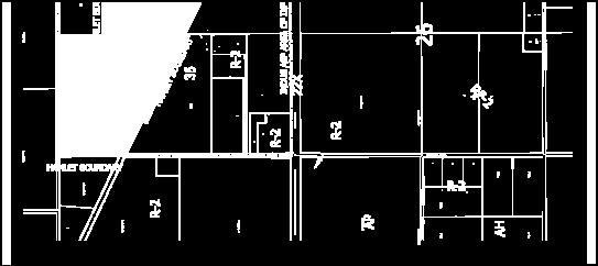
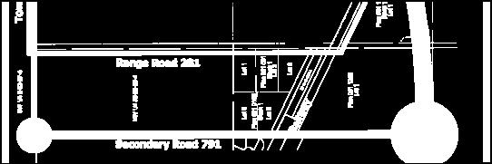
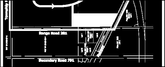
12 3.0 CONCEPTUAL SCHEME AREA 3.1 Regional Location The Conceptual Scheme area is located within the Rocky View County east of the Hamlet of Indus. Provincial Highway 22X bounds it on the south, on the east by Range Road 280, the west by Range Road 281 and on the north by TWP Road 230. Highway 791 runs north south through the Hamlet of Indus and connects to Provincial Highway 22X on the south boundary of the Hamlet and the land. Highway 791 connects with Highway 1 approximately 17 km to the north. Figure is the Regional Context Map Policy Policies within the Fulton Industrial Park Conceptual Scheme shall apply to all the lands within the plan area. Figure Photo Views within the Conceptual Scheme Photo views of the Conceptual Scheme lands Photo 1 View from RR 280 to West to RR 281 and Hamlet of Indus 12

13 Photo 2 View from Highway 22X to North West showing existing agricultural and CPR rail line Photo 3 View from Highway 22X to North showing existing agricultural and CPR rail line 13
14 Photo 4 View from Highway 22X to North East showing existing agricultural Photo 5 View from RR 281 to East showing Agricultural 14
15 Photo 6 View from property to South showing CPR and Highway 22X CPR overpass Photo 7 View from Twp Road 230 to West showing Indus 15
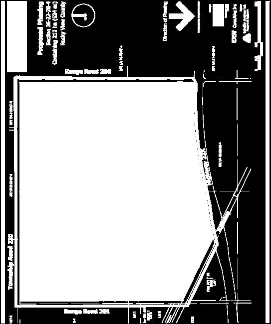
16 3.2 Legal Description Lands controlled by Fulton Industrial JV include an area of approximately 212 hectares ( acres) and are described as: Table 3-2 Land Titles Title Number Description Hectares Acres NW ¼ W4M NE ¼ W4M Part SE ¼ W4M Part SW ¼ W4M Total Area Fulton Industrial JV Ownership Existing Land Use and Development The plan area is currently designated for Ranch and Farm District land use. The past and current use for the land has been for agricultural purposes for approximately 100 years. Figure 3-2 is the Existing Land Use and Land Use Context Map. 3.4 Surrounding Land Use Context Lands north and east of the plan area within portions of Sections 6, 5 and 31 are undeveloped agricultural and are designated Ranch and Farm Residential. Lands west of the plan area within Section 35 and separated by Range Road 281 are within the Hamlet of Indus ASP area of influence and are developed as 5 country residential parcels and a farmstead under cultivation. Lands south of the plan area and separated by Highway 22X are undeveloped Ranch and Farm. The Hamlet of Indus has an existing Indus Area Structure Plan adopted November 9, 2004 that identifies development policies for the Hamlet. The Plan Area includes the Hamlet and the lands surrounding the Hamlet within an approximate half-mile radius. The east boundary of the ASP area of influence touches Range Road 281 and as such does not include the Fulton Industrial lands. Future Country Residential land uses are proposed within the ASP on its east boundary. The Indus ASP identifies several constraints to development for the Hamlet. These constraints include: Highway 791 is a provincial controlled highway. Alberta Transportation has indicated that no new access points will be approved onto Highway 791 from the Hamlet. The CPR rail line is a main line and is very busy. The existing level crossings at Highway 791 and Range Road 282 may pose future conflicts between road and rail. Storm water drainage is an issue preventing development within the Hamlet due to a compromised drainage easement. Lack of piped municipal water and sewer services restricts development. 16
17 The stated Community Vision for the Indus ASP is: To maintain a primarily residential community which supports an agricultural area including: rural acreage and family dwelling subdivisions, schools and an agricultural community center and recreational complex with outdoor sporting facilities and surrounding green space, which facilitates many community and family functions. The vision includes: A residential and agricultural community; Surrounding land to support acreage, farm and residential family dwellings; Subdivisions consisting of single family dwellings and retirement complexes within the Hamlet; Parks and walkways to support the existing recreation center; Commercial development (cottage industry and rural commercial family owned type uses) to serve the needs of and enhance the community; and No further expansion of industrial zoning. Indus ASP policies state: Lands immediately outside the Area of Influence are still considered to be of particular interest to the community and any uses proposed on these lands should reflect compatibility with the goals and objectives and vision for Indus. Other lands surrounding the ASP study area that are primarily full quarter sections of good agricultural land, are considered the agricultural base for the region and should be protected for agricultural operations. Hamlet Commercial and Hamlet Industrial land use is designated in Indus along Railway Avenue adjacent to the CPR line. The ASP states that industrial use developed in a manner sensitive to the community is welcomed. Development of Fulton Industrial Park will assist the Hamlet of Indus in addressing some of its current limitations to development by providing a live, work, and play environment in the area. It is very likely that residential development will be encouraged to develop in the Hamlet as a result of the Fulton Industrial project. 17


18 Figure Regional Context Map 18


19 Figure 3-2 Existing Land Use and Land Use Context 19
20 4. PHYSICAL SITE FEATURES 4.1 Topography The topography of the plan area is gently rolling and is suitable for the intended development. The land is generally lower in elevation from Highway 22X and has excellent visibility from the Highway. The land slopes generally to the north east. Figure 4-1 shows the Topography Plan. 4.2 Hydrology and Geotechnical Considerations In Oct 2008 the Developer retained Almor Testing Services to provide a geotechnical investigation on the lands. The general objectives of the report were to identify significant features of characteristics of the geologic environment that would impact the proposed industrial subdivision project. Their findings are summarized as follows: The soil, bedrock and groundwater conditions do not present any significant constraints for development. The soil consists generally of a layer of till overlying bedrock. Topsoil and browns thickness each range from 200 to 700 mm depth, bedrock is generally below the upper 2 meters. One test hole indicated subsurface groundwater at a depth of 5.8 meters. All other test holes were dry. 4.3 Biophysical Considerations Zanshin Environmental Networks Inc. (ZEN) was retained by Fulton Industrial JV to conduct a biophysical impact assessment (BIA) on lands North of Highway 22X and the Canadian Pacific (CP) Railway in Section 36 Township 22 Range 28 West of the 4 th Meridian, for a proposed industrial park development. The scope of the BIA was to provide: A summary of baseline conditions of selected biophysical resources on the Development property, Identification of potential effects of the Development on the selected biophysical resources, Analysis of the significance of these effects on existing biophysical resources, and Recommendations to appropriately mitigate (negate or minimize negative Development effects), including follow-up and monitoring programs and plans With the exception of a windrow of trees and shrubs on the Eastern edge and one small, remnant, degraded wetland, heavily disturbed by a rock pile in the Southeast quarter, the entire property has been cultivated with cereal crop. Natural vegetation is essentially absent from the property, and associated wildlife habitat is correspondingly meager. The Biophysical Assessment indicates the effects of the development on the biophysical resources assessed are predicted to be negligible. The site lacks natural features; therefore effects of the Development on the existing biophysical resources were minimized through site selection. By applying recommended mitigation measures to potential Development impacts, the only residual development effect identified in the BIA was the change from agricultural to developed land use. 20
21 Policy Disturbance of degraded wetland will be mitigated using recommendations provided in the Biophysical Impact Assessment prepared by Zanshin Environmental Networks Inc., to be approved by the County and Alberta Environment. Policy Policy Policy Policy The Developer will confirm the presence or absence of nesting raptors during the first breeding season prior to development during the period of March 15 to May 15. If nesting raptors are confirmed follow guidelines outlined in Recommended Land Use Guidelines for Protection of Selected Wildlife Species and Habitat within Grassland and Parkland Natural Regions of Alberta (ASRD 2001). Topsoil will be salvaged using a two-lift method separating the A-horizon and the B-horizon. Sediment and erosion control plans shall be provided to meet County and Alberta Environment requirements. The developer shall have an arborist review the viability of the existing trees on the east boundary. If feasible the existing tree windrow will be incorporated into the development. 4.4 Environmental Considerations November 2007, Sabatini Earth Technologies Inc. was retained by the Developer to conduct a Phase 1 Environmental Site Assessment on the lands. The information gathered in the course of this investigation did not reveal evidence of environmental concerns associated with the land. The Sabatini report indicates that the land has been used for agricultural purposes since prior to the 1950s and maintains to be agricultural until the present time. No indication of gas wells within the land is present. Policy If during the course of development, any environmental concerns are identified, notification to Alberta Environment is required. 4.5 Historical Use of the Site The Developer has had discussions with Alberta Culture and Community Spirit, Historical Resources Management. The Department provided a letter dated November 5, 2008 indicating it reviewed the potential for the proposed development to impact historic resources and concluded that a Historic Resources Impact Assessment is not required. It is noted that most of the land has been the subject of cultivation since the early 1900 s. Policy If during the course of development any historic resources are found, notification to Historic Resources Management Branch is required. 21
22 4.6 Existing Structures No structures exist on the land. 4.7 Existing Transportation and Utilities Considerations The lands are contiguous to Highway 22X on the south, Range Road 280 on the east, Range Road 281 on the west and TWP Road 230 on the North. The CPR Rail ROW is contiguous to the southwest boundary. Existing transportation access is as follows: No direct access to the land from Highway 22X Direct access is available from graveled Range Roads 280 and 281, and from TWP Road 230. Spur rail access may be available from the CPR line. Highway 22X is a major 2 lane paved highway. TWP Road 230 connection to the developed lands north of the Conceptual Scheme area is a 2 lane graveled road which connects to Secondary Road 791 to the west. Range Road 280is a two lane graveled surface road which connects to Highway 22X. Some of the boundary roads and intersections will have to be upgraded before full development occurs. Scheffer Andrew Ltd. has been retained to provide analysis of the current road systems and make recommendations for upgrades to meet anticipated future development needs. The land is currently used for agricultural purposes and has no utility services adequate for the anticipated development. All utility services will be required to be provided or developed on site. Policy Prior to development new internal road infrastructure will be required as identified by a Transportation Impact Assessment that has been prepared by a qualified transportation engineer subject to approval by the Municipality and Alberta Transportation. 22


23 Figure 4-1 Topography Plan 23

24 Figure 4-6 Existing Features Plan 24
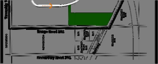
25 5. LAND USE AND SUBDIVISION DESIGN CONCEPT 5.1 Overview Fulton Industrial Park will be developed as a limited services industrial park servicing the needs of large and small lot industrial clients wishing to be located outside the City of Calgary and near major traffic infrastructure linkages. Fulton Industrial Park will be geographically near the rapidly growing south east sector of the City of Calgary. Important connections to major transportation linkages include Highway 22X, Secondary Highway 791 and their connections to the Calgary Ring Road infrastructure, Highway 1 and Highway 2. This section identifies policies to provide a framework for the Conceptual Scheme with respect to land use, subdivision, and development. Development of the land may, if agreed by the developer and the County, provide possible opportunity for regional storm water solutions for the Indus area. 5.2 Land Use Concept Fulton Industrial Park will provide limited services industrial land use within the entire site area. The project is designed to accommodate a wide variety of industrial clients including large lot open storage, manufacturing, and distribution/logistics. Smaller lot requirements are also be provided within the development. Lot sizes are anticipated to range from 2.5 to 100 acres. The proposed land uses will take advantage of the existing regional transportation network and will provide employment and economic benefits to the area. The development will be planned in a logical manner. It is anticipated that local commercial facilities to provide services to the industrial users and the Hamlet of Indus will locate within the development area. Expected types of commercial facilities include coffee shop, small restaurant / food services, gas bar / automotive services. A possible location for local commercial is shown on the development concept map and is subject to change. The Developer proposes to use the existing Rocky View County I-IA bylaw for the development and will request that the entire parcel be zoned at the initial application for redesignation. The Local Commercial land will require a redesignation application at the time of need for this land use. Internal collector road systems will be designed to facilitate efficient movement of traffic and will minimize the number of connection points to existing municipal road systems. The collector road will connect to Township Road 230 on the north and to Range Road 280 on the east. Storm water management facilities will be located within the industrial lands. These will be developed with fire storage capacity. The storm water management facilities will be dedicated as Public Utility Lots (PUL). Current storm water solutions will permit up to 65% of the lands to be developed. MR is provided at the edges of the internal storm ponds. A consolidated area of MR is provided on the southwest portion of the land to provide open space large enough to develop four future tournament sized soccer fields, parking and support facilities. The consolidated MR is located on Range Road 281 to also allow for future connectivity to Indus and may connect to the internal development collector road system. The consolidated MR is located to provide a buffer to the existing country residential lands to the west. Lots along Range Road 281 shall be considered transition lots that provide a buffer to more intense industrial uses from future country residential land use to the west. 25
26 Figure shows the Development Concept Map Table 5-2 Approximate Development Statistics Proposed Proposed Use Area (hectares approx) Area (acres approx) Area (%) Industrial Storm Ponds (Public Utility Lots) Proposed Roadways Internal Municipal Reserve Total Note: Table 5-2 areas are conceptual only and are subject to revision. Policy Public Utility Lots and Municipal Reserve will be dedicated at the time of Subdivision. 5.3 Phasing The land will be developed in phases to accommodate market considerations, demand, and staged development of storm water and transportation infrastructure. Figure shows the Proposed Subdivision Phasing Map Policy Policy The development will be phased and will proceed based on market conditions and where infrastructure is available to meet the requirements of the proposed phase of development. The pattern of phasing will occur generally from north to south within the development. Changes to the phasing of development will be allowed without modification to the Conceptual Scheme. 5.4 Subdivision The developer will follow current Rocky View County subdivision requirements when applying for subdivision of the lands. It is anticipated that 6 to 8 subdivision phases will be required for this project. The subdivision phases may or may not all be contiguous. If a phase is separated from others it will be required to be serviced. The developer has had experience in other Alberta jurisdictions with a subdivision process that provides flexibility, saves time, and creates an atmosphere as a place to do business. In an effort to create efficiency and simplify the subdivision process for both the County and developer, the developer proposes the following: 26
27 A Master Site Subdivision Plan (MSSP) for the entire project will be prepared by the developer after land use is approved for the project. The MSSP will show the conceptual pattern of subdivision and phasing and will be used as an administrative tool by the developer and Rocky View administration forming the basis for subsequent subdivision applications. The MSSP will identify maximum lot density for the site and show proposed lot layout and phasing and may be amended to accommodate changing market conditions upon agreement of the Municipality, noting however that lot density shall not be increased. The Conceptual Scheme notes that up to 65% of the land is developable before additional storm water solutions are provided. It will be possible for the County to monitor the percentage of land being approved for subdivision using the MSSP. In order to develop the entire parcel and to contribute to a regional solution, the developer will work with the Municipality to determine interim and long-term infrastructure including implementation and construction that would provide storm water outfall for the Indus area. It is noted that subdivision approval for land adjacent to Highway 22X may not be approved by Alberta Transportation until the agency has completed a functional study of the Highway. Policy Policy Policy Policy Policy Policy This Conceptual Scheme document will be used as the guiding planning document for Land Use and Subdivision applications. Subdivision of each phase of development will create roads, rights of way, utility parcels, easements and parcels for development. The number, size and layout of lots will be determined at the time of and through the subdivision approval process. The developer will not apply for subdivision of lots beyond 65% of the land until a storm water solution is provided for the remaining 35% of the land and is accepted by the Municipality. At future stages of subdivision, the developer will enter into a Cost Contribution Agreement with the County for the implementation and construction of storm water infrastructure in the Indus area. Subdivision phases that are not contiguous will be required to be serviced with roads and services that connect with other phases. Subdivision of land adjacent to Highway 22X will be subject to approval by Alberta Transportation 27


28 Figure Development Concept 28

29 Figure Proposed Subdivision Phasing 29
30 6.0 DEVELOPMENT STANDARDS 6.1 Land Use Bylaw The Land Use Bylaw will be the existing Rocky View County I-IA Bylaw within the Conceptual Scheme. Policy Policy Policy Development Performance Standards will be implemented through the development permit process in accordance with Conceptual Plan policies and the Land Use Bylaw. At the discretion of the Approving Authority, a stripping and grading permit may be issued provided among other things, the following conditions have been met: a preliminary grading plan depicting road and swale grades including the Public Utility Lot(s) area(s), a Storm Water Management Plan, an Erosion and Sedimentation Control Plan, and a Construction Management Plan are approved by Rocky View County and Alberta Environment. The stripping and grading area shall be limited, where possible, to the proposed development area of the subdivision application. 6.2 Building & Development Architectural Controls The quality of development will be established and maintained using Building and Development Architectural Controls. These controls will identify requirements for landscaping, signage, building design and finishes appropriate to their intended use, buffers to adjacent land uses, overland storm water management on each lot, fencing and on-site storage These controls will be used to encourage a visually attractive development along the boundary edges of the Conceptual Scheme area. Building and Development Architectural Controls shall address the following: A minimum 1.5 meter wide curbed landscaped strip will be provided along the frontage of each lot. A Landscape plan will be submitted for each development application and shall identify that permanent plant material is hardy to the Calgary region, requires little or no irrigation, and uses consistent tree selection along the streetscape. Sites along Range Road 281 shall provide screening and landscaping at the back of the lots to buffer impact to properties to the west. Buildings within sites along Range Road 281 shall have a height limitation of 12 meters to provide a transition and human scale to properties to the west. Large scale parking areas will be located at the sides and rear of buildings. Storage, service and loading areas will be placed at the sides and or rear of the building. Loading and storage areas will be screened from public roadways. Site and exterior building lighting will be designed using night sky principles with a full cut-off in order to direct light to the ground and prevent spillage to adjacent sites and to the sky. 30
31 Site lighting along boundary roads will be designed to eliminate glare viewed from neighbouring properties. Lot parking and outdoor storage areas should use LID principles and use permeable paving, on site stormwater storage, and bioswales to manage on site stormwater runoff to the development storm system. Fencing at the front of buildings is discouraged. When it is required it will be low scale and decorative in design and located behind streetscape landscaping. Building massing design along the fronts of buildings shall incorporate different materials and colours, offsets, and provide pedestrian scaling devices. Entrances to the Fulton Industrial Park will incorporate site signage identifying the park. Design of the Park entry signs will reflect the rural character of Indus and the surrounding community. Lot and building signage is subject to approval and shall be compatible with the building design. A landscaped paved pedestrian pathway will be developed on one side of each collector road, at each storm water management pond and the link connecting the ponds. The use of green building products is encouraged. The Building and Development Guidelines will be registered through an encumbrance on each title. Policy Policy The County s Commercial, Office and Industrial Design Guidelines should be considered in building and development plans. A Lot Owners Association or designated committee will be responsible for reviewing building and site design plans and providing recommendations to the County. 31
32 7.0 TRANSPORTATION 7.1 Traffic Impact Assessment Scheffer Andrew Ltd. was retained by Fulton Industrial JV to undertake a traffic impact study in October 2008, in support of Fulton Industrial Park ASP in M.D. Rocky View. Because functional planning by Alberta Transportation for Highway 22X adjacent to the site has not yet been completed, the TIA provides for two options for access from the Provincial Highway system: Option 1 Primary access to the development will be provided by way of Township Road 230, which intersects with Secondary Highway 791, and Range Road 280, which intersects with Highway 22X With full build out of the site, the intersection of Township Road 230 and SH 791 will require upgrading, but no signalization. The intersection of Range Road 280 and Highway 22X will require upgrading as well as signalization. Option 2 Primary access to the development will be provided by way of Township Road 230, which intersects with Secondary Highway 791. The intersection of Range Road 280 with Highway 22X is closed under this option, but it is likely that Township Road 230 would then be extended east to intersection the next available North-South Road or Highway which does intersect with Highway 22X. However, for the purposes of analysis, all traffic has been assigned to the intersection of Township Road 230 and Highway 791. Both upgrading and signalization will be required at the intersection of Township Road 230 and Highway 791 Both Range Road 280 and Township Road 230 will be upgraded to a paved standard as required. Policy Policy Policy Additional TIA updates will be prepared at the completion of each development phase to determine upgrade requirements to the regional road infrastructure. The recommendations of the Fulton Industrial Transportation Impact Assessment shall be implemented through provisions of the Land Use Bylaw and Subdivision Approval. Changes to road infrastructure required by Alberta Transportation as a result of the future Highway 22X functional study will not require an amendment to this Conceptual Scheme. 32
33 7.2 Internal Road System The internal collector road system provides a looped road designed to an urban cross section using concrete curbs and gutters. The collector road connects to Township Road 230 on the north boundary and to Range Road 280 on the east boundary. Additional collector roads may be provided subject to final lot layout and subdivision plans. Policy Policy Policy Collector roads will be designed to meet Rocky View County standards. Internal collector roads shown on the transportation plan as identified in Figure Proposed Transportation Network are conceptual in layout and are subject to change. Access to each subdivided lot will meet Rocky View County requirements. 33

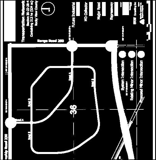
34 Figure Transportation Network 34
35 8.0 PUBLIC SPACES 8.1 Boundary Conditions Fulton Industrial Park is bounded on the west by Range Road 281 on the North by Township Road 230 and farm and ranch properties, on the East by Range Road 280 and farm and ranch properties, and on the South by Highway 22X and the CPR rail line. A windrow of old poplars exists on both sides of Range Road 280. The existing poplar windrow has been reviewed by a qualified arborist and is determined to be old with a limited life span. 8.2 Municipal Reserve, Open Space and Pathways Up to 10% of the plan area is required by the Municipal Government Act to be dedicated as municipal reserve or municipal school reserve. The Act also allows developers to defer municipal reserve, provide funds in lieu of reserve, or to provide a combination of land and money. At this time there exists no regional trail network in or around the Hamlet of Indus. The Conceptual Scheme identifies land to be used as Municipal Reserve dedication.. A consolidated open recreation space large enough for development of up to four tournament size soccer fields with parking and support facilities is provided at the south west area of the land. The open recreation space is aligned on Range Road 281 to provide future connectivity to the Hamlet. Additional MR is provided on the boundaries of the internal storm water ponds. Internal public pathways are provided in the MR surrounding the storm water ponds. Security fencing will be provided by end users at a predetermined standard along the interior edge of the boundary MR to provide security, screening and prevent access into the industrial developed areas. This fencing will be designed to meet Rocky View County standards for delineation of MR land. Policy Policy Policy Policy Municipal Reserve may be provided through a combination of dedication of land and payment of cash-in-lieu as required under the provisions of the Municipal Government Act. A Municipal Reserve open recreation space will be provided. Low Impact Development principals will be used in designing landscaping and plant selection to provide hardy, low maintenance planting. Fencing separating boundary MR from development land shall be to the satisfaction of Rocky View County. 8.4 Environmental Reserve Zanshin Environmental Networks Inc prepared a Biophysical Impact Assessment for this proposed development. This BIA did not identify any land as environmental reserve. 35


36 Figure Municipal Reserve 36
37 9.0 UTILITY SERVICING STRATEGY 9.1 Limited Services Currently there are no municipal or regional services available to this land, therefore this site will be developed as a limited service development in the short term. However in recognition of the potential for a future demand for piped infrastructure services in the park and the greater Indus area, the developer will work with the Municipality to determine solutions and contribution to future piped infrastructure. Policy Policy Limited services sites will be allowed throughout the development At future stages of subdivision, the developer will enter into a Cost Contribution Agreement with the County for the implementation and construction of waste water infrastructure in the Indus area. 9.2 Water Each end user will provide potable water, in accordance with the rights and obligations outlined in the Alberta Water Act and the regulations related thereto. Policy Potable water services may be supplied to industrial users using trucked in water to on-site cisterns to the satisfaction of the Municipality. 9.3 Sanitary Sewer Each lot purchaser will provide its own on site sanitary servicing solution. Pump out tanks are anticipated. In anticipation of the potential for a future demand for piped sanitary sewer in the park and greater Indus area, the developer will work with the Municipality to determine appropriate solutions and contribution to a regional waste water solution. Policy Policy Sanitary sewer collection, containment, and disposal systems shall be approved by Alberta Environment and the Municipality. At future stages of subdivision, the developer will enter into a Cost Contribution Agreement with the County for the implementation and construction of waste water infrastructure in the Indus area. 9.4 Storm Sewers On site storm drainage will be achieved by utilizing a combination of swales and piped storm system all leading to the on site storm water management ponds. The underground piped system will be sized for the 5-year event, with provision in the above ground road design for overland flow. A piped storm sewer connection will be provided to each site. Each site will be required to restrict the runoff from their site at a flow rate of 70 L/Sec/ha. Various methods of stormwater control include parking lot storage, roof top storage, underground storage and storm pond storage. 37
38 It is anticipated that the alignment of the underground storm water will be placed between the paved portion of the road and the property line in the road right of way. Policy Policy Policy Policy Development of on site storm sewer collection and distribution shall be designed by a qualified engineer and approved by the Municipality. End user on site storm sewer collection and distribution shall be designed by a qualified engineer prior to approval by the Municipality. Storm water runoff from sites shall be restricted to 70L/Sec/ha. At future stages of subdivision, the developer will enter into a Cost Contribution Agreement with the County for the implementation and construction of storm water infrastructure in the Indus area. 9.5 Storm Water Management Scheffer Andrew Ltd prepared a conceptual Storm Water Management Plan for the Developer in October The existing topography indicates that the drainage basin boundaries for the development can be contained within the development area. Existing drainage from outside the area either drains away from the area, or is directed to existing ditches that drain away from the area. Therefore, the major storm water management facilities designed for the plan area does not need to account for storm water runoff from lands outside the plan area. Stormwater management for Fulton Industrial Park will primarily consist of a surface and underground system to accommodate minor 1:5 year storm events consistent with Rocky View County standards, and end-of-pipe treatment via hydraulically linked wet ponds. The storm water management facilities (SWMFs) will be designed to service both the internal road network and individual properties. Major storage and drainage facilities will be provided to accommodate the 1:100 year event, in accordance with Rocky View County standards. The proposed treatment facilities will be storm water management (SWM) facilities which will provide for attenuation of storm water flows and removal of sediment in accordance with Alberta Environment Guidelines, as well as removal of nutrients to restore the storm water pre-development water flow and quality. This will be accomplished through the use of proven technology such as bioswales, fore bays, and constructed wetland zones that will be incorporated into the upper and lower reaches of the SWM facilities. There is little opportunity in the immediate vicinity of the site to provide a gravity outlet for the treatment facilities. The topography of the site is generally flat and there is no well-defined route for drainage away from the site. The SWM study for Indus, recently completed by the Rocky View County, indicates a flow route for draining the Hamlet and surrounding area to the south and east. However, the flow route has not been adequately analyzed, and may be difficult to approve and construct. The Developer has investigated the possibility of a pumping station to pump water from the Fulton Industrial treatment facilities to the Bow River, 12KM to the south, via an underground force main. If such an outlet is constructed it is anticipated that the Hamlet of Indus, surrounding area, and future development could use this infrastructure as well. If deemed to be financially feasible by Rocky View County this could provide a regional solution to stormwater management developed in a cooperative manner. An appropriate cost sharing mechanism would need to be negotiated and implemented. The developer will work with Rocky View County to deal with regional storm water management solutions. 38
39 The ultimate storm water management system in Fulton Industrial Park is designed to provide a wet pond or wetland system; with a piped outfall developed at the time an approved outfall is provided. In the initial phases of the development the Fulton Industrial SWMFs will be used as evaporation ponds with no outflow. Generally, the size of the two pond concept used as evaporation ponds can be sized to provide for 65% of the developed land area. At the point of development of more than two thirds of the land the storm water pump station and outfall will be required or alternate solutions provided. Policy Policy Policy Policy Policy Policy Policy Policy Policy All storm water management within the plan area shall be designed and constructed to meet the Municipality, Alberta Environment and Alberta Infrastructure standards in accordance with the approved storm water management plan. Storm water management may be designed to facilitate future regional storm water solutions if required by the approving authority, with appropriate cost sharing mechanisms in place. Storm pond storage and treatment facilities shall be designed prior to approval of subdivision and development permit to meet the Rocky View County and Alberta Environment treatment requirements. The storm water management facilities within the Conceptual Scheme area shall be constructed and maintained by the Developer until dedicated upon final acceptance to Rocky View County. Final design criteria and agreements with approving authorities including the Municipality for storm water management will be required at the time of Subdivision. 65% of the land area may be developed using appropriately sized evaporation ponds. Development beyond 65% requires additional approved storm storage or outfall system satisfactory to the Rocky View County. At future stages of subdivision, the developer will enter into a Cost Contribution Agreement with the County for the implementation and construction of storm water infrastructure in the Indus area. A storm water management plan and erosion and sedimentation control plan shall be prepared satisfactory to the County prior to any site works proceeding. Post development storm water runoff to adjacent lands will be limited to predevelopment quantities using best management technical practices to quantify and qualify the storm water runoff. 39
40 9.6 Fire Protection The Developer will provide fire protection within the Conceptual Scheme area with the use of the Storm Water Management ponds accessed with dry standpipes to allow for the filling of pumper trucks during fire extinguishing. The ponds and standpipes will be accessible by emergency vehicles. Some lot purchasers will rely on fire pond storage for fire fighting while others will require sprinklers for their buildings and as a result will need to provide their own storage reservoir for fire fighting. These on-site facilities will be custom designed and installed by the end user to meet the specific needs of that user. It is anticipated that these needs can be met through the possible combinations of on-site SWM ponds, storage tanks, on-site pumping systems and replenishment wells. Policy Policy Common storm water retention facilities and dry hydrants shall provide centralized fire protection to the satisfaction of the Municipality. Individual sites will provide additional fire protection systems to meet sitespecific requirements. 9.7 Solid Waste Management Solid waste will be contained on site by the end users using devices to prevent scattering and odours. Enforcement of potential contaminants, odours, noise control, toxic matter handling, and fire hazards shall be controlled by an encumbrance registered on each title as part of the Building and Development Guidelines. A collection system acceptable to the Rocky View County will be provided by each lot owner to remove solid and recyclable waste on a timely basis to land fill and recycle facilities within or outside the Municipality. Policy Solid waste management shall be the responsibility of lot owners. 9.8 Shallow Utilities Electrical power services shall be provided by means of overhead lines. Telephone, internet, CATV and gas distribution shall be provided in accordance with the requirements of the franchise utilities. These services will be extended into the development on a phased basis at the time of development. Shallow utilities will be installed within road rights of way or in separate rights of way adjacent to the roads subject to Municipality approval. Policy Policy Shallow utilities will be installed in the plan area on a phased basis. The Developer will provide required rights of way to utility companies that require them. Utility servicing shall be designed by a qualified engineer and shall be approved by the Municipality. 40


41 Figure Storm Water Management 41
Leduc Industrial Outline Plan SE W4
 Leduc Industrial Outline Plan SE 1-50-25-W4 Within the North Leduc Industrial ASP Prepared for: Leduc Energy Park Ltd. Prepared by: Stantec Consulting Ltd. File No. 1161 104655 V5 Table of Contents 1.0
BYLAW C A Bylaw of Rocky View County to amend Land Use Bylaw C
 BYLAW C-7720-2017 A Bylaw of Rocky View County to amend Land Use Bylaw C-4841-97. The Council of Rocky View County enacts as follows: PART 1 TITLE This Bylaw shall be known as Bylaw C-7720-2017. PART 2
City of Grande Prairie Development Services Department KENNEDY DEVELOPMENTS LTD. OUTLINE PLAN OP-09-01
 City of Grande Prairie Development Services Department KENNEDY DEVELOPMENTS LTD. OUTLINE PLAN OP-09-01 July 27, 2009 TABLE OF CONTENTS 1.0 Introduction... 1 1.1 Plan Area Location & Context... 1 1.2 Ownership
WEST HILL BUSINESS PARK AREA STRUCTURE PLAN
 MUNICIPAL DISTRICT OF PEACE NO. 135 WEST HILL BUSINESS PARK AREA STRUCTURE PLAN Prepared by: TABLE OF CONTENTS 1.0 Introduction... 1 1.1 Purpose of Plan........ 1 1.2 Plan Area..... 1 1.3 Existing Conditions...
Red Fox Commercial Outline Plan
 Red Fox Commercial Outline Plan City of Cold Lake, Alberta Prepared by Durrance Projects Ltd and Ross W. Sharp & Associates Ltd October 2014 Rupert 1 Table of Contents 1. PURPOSE...3 1.1. Location...4
S o u t h C e n t r a l O u t l i n e P l a n. Leduc Business Park. North Leduc Industrial Area Structure Plan C it y of Led u c.
 Leduc Business Park North Leduc Industrial Area Structure Plan C it y of Led u c Prepared for Farm Air Properties Inc. January, 2007 Table of Contents Page Number 1.0 Purpose of Plan and Definition of
WESTMINSTER GLEN CONCEPTUAL SCHEME
 WESTMINSTER GLEN CONCEPTUAL SCHEME Bylaw C-5379-2001, Adopted July 31, 2001 MUNICIPAL DISTRICT OF ROCKY VIEW NO. 44 Department of Planning and Development MUNICIPAL DISTRICT OF ROCKY VIEW NO. 44 BYLAW
Bylaw C-1186 Adopted November 5, Planning and Development Services
 Bylaw C-1186 Adopted November 5, 2007 Planning and Development Services CITY OF GRANDE PRAIRIE OFFICE CONSOLIDATION BYLAW C-1186 A Bylaw to adopt the Westgate Area Structure Plan (As Amended by Bylaw C-1186-1,
OP Council Resolution June 16, Planning and Development Services
 OP-08-01 Council Resolution June 16, 2008 Planning and Development Services Kingsgate Landing Outline Plan Table of Contents 1.0 Introduction 1 1.1 Purpose of Plan 1 1.2 Plan Area Location 1 1.3 Ownership
Palisades Outline Plan
 NE ¼ 25 36 28 W4 Town of Penhold Approved August 13, 2012 Contents Figures & Tables... 2 Introduction... 1 Overview... 1 Purpose... 1 Development Area... 3 Ownership... 3 Topography... 3 Existing & Surrounding
City of Grande Prairie Development Services Department
 City of Grande Prairie Development Services Department ROYAL OAKS NORTH OUTLINE PLAN OP-07-03 NW 35-71-6 W6M May 7, 2007 Royal Oaks North Outline Plan TABLE OF CONTENTS 1.0 INTRODUCTION........ 3 1.1 Purpose
C ity of Grande Prairie Development Services Department
 C ity of Grande Prairie Development Services Department FAIRWAY DEVELOPMENT OUTLINE PLAN OP 08 09 Approved April 6, 2009 Prepared by: Focus Corporation Table of Contents 1.0. Introduction 2 3 1.1. Plan
ARTICLE 6: Special and Planned Development Districts
 ARTICLE 6: Special and Planned Development Districts 6-10 Traditional Neighborhood Development (TND) District 6-10.10 Purpose and Intent The Traditional Neighborhood Development (TND) District provides
INDUS AREA STRUCTURE PLAN
 INDUS AREA STRUCTURE PLAN Bylaw C-5982-2004, Adopted November 9, 2004 MUNICIPAL DISTRICT OF ROCKY VIEW NO. 44 Department of Planning and Development MUNICIPAL DISTRICT OF ROCKY VIEW NO. 44 BYLAW C-5982-2004
LAND USE AMENDMENT CORNERSTONE (WARD 3) 60 STREET NE AND COUNTRY HILLS BOULEVARD NE MAP 26NE BYLAW 22D2017
 60 STREET NE AND COUNTRY HILLS BOULEVARD NE MAP 26NE BYLAW 22D2017") Page 1 of 14 EXECUTIVE SUMMARY This Land Use Amendment application covers an area of 43.76 hectares ± (108.14 acres ±) located in northeast Calgary, bound by Country Hills Boulevard NE to the south and
Page 1 of 14 EXECUTIVE SUMMARY This Land Use Amendment application covers an area of 43.76 hectares ± (108.14 acres ±) located in northeast Calgary, bound by Country Hills Boulevard NE to the south and
LAND USE AMENDMENT CORNERSTONE (WARD 3) COUNTRY HILLS BOULEVARD AND STONEY TRAIL NE BYLAW 9D2017
 COUNTRY HILLS BOULEVARD AND STONEY TRAIL NE BYLAW 9D2017") Page 1 of 12 EXECUTIVE SUMMARY This Land Use Amendment application covers an area of 54.92 hectares ± (135.71 acres ±) located in northeast Calgary, bound by Country Hills Boulevard NE to the north and
Page 1 of 12 EXECUTIVE SUMMARY This Land Use Amendment application covers an area of 54.92 hectares ± (135.71 acres ±) located in northeast Calgary, bound by Country Hills Boulevard NE to the north and
ADMINISTRATION RECOMMENDATION 2016 November 03. That Calgary Planning Commission recommends APPROVAL of the proposed Land Use Amendment.
 Page 1 of 12 EXECUTIVE SUMMARY This Land Use Amendment application covers an area of 75.76 hectares ± (187.20 acres ±) located in northeast Calgary, bound by Stoney Trail NE to the north, 128 Avenue NE
The West Vaughan Employment Area Secondary Plan Policies
 Part 2: The West Vaughan Employment Area Secondary Plan Policies 2.1 General Policies It is the policy of Council: 2.1.1. That the West Vaughan Employment Area (the WVEA), identified on Schedule 1, will
AREASTRUCTURE PLAN AMENDMENT COCHRANE NORTH
 AREASTRUCTURE PLAN AMENDMENT COCHRANE NORTH In order to implement the vision outlined in the Conceptual Scheme, the following three amendments to the Cochrane North ASP are proposed: 1. Allow commercial
Bylaw C-1262 Adopted February 6, Planning and Development Department
 Bylaw C-1262 Adopted February 6, 2012 Planning and Development Department CITY OF GRANDE PRAIRIE BYLAW C-1262 A Bylaw to adopt the Brookfield Neighbourhood Outline Plan THE MUNICIPAL COUNCIL OF THE CITY
HAMLET OF KINGMAN AREA STRUCTURE PLAN
 HAMLET OF KINGMAN AREA STRUCTURE PLAN Prepared by: Austrom Consulting Ltd. Page 1 of 19 Table of Contents TABLE OF CONTENTS... 2 1. BACKGROUND... 3 1.1 PLAN AREA... 3 1.2 PLAN PURPOSE... 3 1.3 LEGISLATIVE
TABLE OF CONTENTS 1.0 INTRODUCTION GENERAL OBJECTIVES LAND USE DESIGNATIONS, OBJECTIVES AND POLICIES 4
 Schedule I- Redstone Golf Course Resort Area Sector Plan 1 TABLE OF CONTENTS 1.0 INTRODUCTION 3 2.0 GENERAL OBJECTIVES 3 3.0 LAND USE DESIGNATIONS, OBJECTIVES AND POLICIES 4 4.0 TRANSPORTATION AND ROAD
Outline Plan in Belvedere (Ward 9) at Street SE, LOC (OP)
 at Street SE, LOC (OP)") 2018 October 04 Page 1 of 12 EXECUTIVE SUMMARY This outline plan application was submitted by B&A Planning Group on 2016 July 15, on behalf of Tristar Communities Inc. for 50.14 hectares (123.89 acres)
2018 October 04 Page 1 of 12 EXECUTIVE SUMMARY This outline plan application was submitted by B&A Planning Group on 2016 July 15, on behalf of Tristar Communities Inc. for 50.14 hectares (123.89 acres)
Master Site Development Plan (MSDP) Rocky View County Campus at Balzac East
 Rocky View County Campus at Balzac East") Master Site Development Plan (MSDP) Rocky View County Campus at Balzac East Balzac East, Alberta July 2009 CONTENTS 1.0 purpose 1 2.0 guiding principles 2 3.0 site description 3 4.0 site analysis and county
Master Site Development Plan (MSDP) Rocky View County Campus at Balzac East Balzac East, Alberta July 2009 CONTENTS 1.0 purpose 1 2.0 guiding principles 2 3.0 site description 3 4.0 site analysis and county
MUNICIPAL DISTRICT OF ROCKY VIEW NO.
 BEARSPAW AREA STRUCTURE PLAN Bylaw C-4129-93, Adopted January 18, 1994 MUNICIPAL DISTRICT OF ROCKY VIEW NO. 44 Department of Planning and Development BEARSPAW AREA STRUCTURE PLAN BY-LAW C-4129-93 January,
GRAYSTONE ESTATES CONCEPTUAL SCHEME
 GRAYSTONE ESTATES CONCEPTUAL SCHEME Bylaw C-5438-2001, Adopted November 6, 2001 MUNICIPAL DISTRICT OF ROCKY VIEW NO. 44 Department of Planning and Development TABLE OF CONTENTS 1.0 INTRODUCTION 5 1.1 Conceptual
MUNICIPAL DEVELOPMENT PLAN
 MUNICIPAL DEVELOPMENT PLAN Bylaw C-4840-97 Adopted on July 6, 1998 MUNICIPAL DISTRICT OF ROCKY VIEW NO. 44 Department of Planning and Development & Building Services MUNICIPAL DISTRICT OF ROCKY VIEW NO.
Municipal Development Plan. Summer Village of ROCHON SANDS. Bylaw #241-18
 Municipal Development Plan Summer Village of ROCHON SANDS Bylaw #241-18 TABLE OF CONTENTS PART ONE: BACKGROUND AND PURPOSE 3 SECTION 1: BACKGROUND 3 SECTION 2: GOALS AND POLICIES 3 PART TWO: PHYSICAL ENVIRONMENT
CENTRAL PARK MAJOR AREA STRUCTURE PLAN. Bylaw No. 2017/30, Adopted February 20, P a g e
 CENTRAL PARK MAJOR AREA STRUCTURE PLAN Bylaw No. 2017/30, Adopted February 20, 2018 1 P a g e Table of Contents 1.0 Introduction 4 1.1 Background 4 1.2 Purpose 4 1.3 Location 4 1.4 Planning Process 4
ADMINISTRATION RECOMMENDATION(S) 2017 June 15. That Calgary Planning Commission recommends APPROVAL of the proposed Land Use Amendment.
 2017 June 15. That Calgary Planning Commission recommends APPROVAL of the proposed Land Use Amendment.") Page 1 of 7 EXECUTIVE SUMMARY The proposed land use amendment seeks to redesignate a Special Purpose Future Urban Development (S-FUD) District parcel in Residual Ward 3 Sub Area 3H to Industrial Outdoor
Page 1 of 7 EXECUTIVE SUMMARY The proposed land use amendment seeks to redesignate a Special Purpose Future Urban Development (S-FUD) District parcel in Residual Ward 3 Sub Area 3H to Industrial Outdoor
The Uplands Area Structure Plan. City of Cold Lake, NE & SE W4
 City of Cold Lake, NE & SE 13-63-2-W4 July 2009 1 Contents 1 Background information... 1 1.1 Foreword... 1 1.2 Purpose... 1 1.3 Plan Area and Location... 1 1.4 Ownership... 2 2 Factors Influencing Development...
THE CITY OF VAUGHAN BY-LAW BY-LAW NUMBER
 THE CITY OF VAUGHAN BY-LAW BY-LAW NUMBER 123-2013 A By-law to designate the whole of the City of Vaughan as a Site Plan Control Area, and to adopt site development guidelines and rules of procedure for
CottageClub Ghost Lake Conceptual Scheme
 CottageClub Ghost Lake Conceptual Scheme Bylaw C-6585-2007, Adopted January 15, 2008 MUNICIPAL DISTRICT OF ROCKY VIEW NO. 44 Department of Planning and Community Services MUNICIPAL DISTRICT OF ROCKY VIEW
Land Use Amendment in Southwood (Ward 11) at and Elbow Drive SW, LOC
 at and Elbow Drive SW, LOC") 2018 November 15 Page 1 of 10 EXECUTIVE SUMMARY This land use amendment application was submitted by Rick Balbi Architect on 2017 August 31 on behalf of Sable Developments Ltd, and with authorization from
2018 November 15 Page 1 of 10 EXECUTIVE SUMMARY This land use amendment application was submitted by Rick Balbi Architect on 2017 August 31 on behalf of Sable Developments Ltd, and with authorization from
BRIDGES OF LANGDON CONCEPTUAL SCHEME
 BRIDGES OF LANGDON CONCEPTUAL SCHEME Office Consolidation This page contains the history of relevant bylaws affecting this office consolidation. A copy of the original Bylaw and all amending Bylaws can
OFFICE CONSOLIDATION SECONDARY PLAN AREA 22 THE BRAMALEA SOUTH INDUSTRIAL SECONDARY PLAN
 OFFICE CONSOLIDATION SECONDARY PLAN AREA 22 THE BRAMALEA SOUTH INDUSTRIAL SECONDARY PLAN November 2010 EXPLANATORY NOTES (Secondary Plan Area 22) General (pertaining to all secondary plan office consolidations)
Prepared for: Prepared by: Revised November 2013 by Stantec Consulting Ltd. 200, th Street Se Calgary, AB, T2A 7H8
 Prepared for: Prepared by: PLANNING PROTOCOL INC. 3916 1 ST STREET N.E. CALGARY, AB. T2E 3E3 Revised November 2013 by Stantec Consulting Ltd. 200, 325 25 th Street Se Calgary, AB, T2A 7H8 Table of Contents
SANDSTONE SPRINGS AREA STRUCTURE PLAN
 Sandstone Springs Development Corp. AREA STRUCTURE PLAN This report is prepared for the sole use of Sandstone Springs Development Corp. No representations of any kind are made by Urban Systems Ltd. or
Bylaw No. B-03/2011 Adopted by Airdrie City Council February 21, 2012
 COOPER S CROSSING STAGE 4 Neighbourhood Structure Plan City of Airdrie WESTMARK HOLDINGS LTD. Bylaw No. B-03/2011 Adopted by Airdrie City Council February 21, 2012 CONSULTANTS: LAND USE PLANNING: Southwell
DAMKAR LANDS An Amendment to Bylaw C being the Watermark Conceptual Scheme
 APPENDIX 8 DAMKAR LANDS An Amendment to Bylaw C-6798-009 being the Watermark Conceptual Scheme Table of Contents 1.0 Introduction 1.0 Development Objectives 1 3.0 History, Vision and Guiding Principles
TABLE OF CONTENTS. Sierra Springs Outline Plan
 Sierra Springs Outline Plan TABLE OF CONTENTS 1. Introduction...3 1.1. Purpose of the Plan... 3 1.2. The Approval Process... 3 1.3. Policy and Legislative Framework... 3 2. Development Area...6 2.1. Location
Rezoning. Rezone from A-1 to RH to create 9 suburban single family residential lots. Approval to Proceed
 City of Surrey PLANNING & DEVELOPMENT REPORT Rezoning Proposal: Rezone from A-1 to RH to create 9 suburban single family residential lots. Recommendation: Approval to Proceed Location: 18712 and Portion
Description of Preferred Alternative
 Chapter 2 Description of Preferred Alternative 2.1 Introduction This chapter of the programmatic Sammamish Town Center Sub-area Plan Final EIS provides a more detailed description of the Preferred Alternative
ROAD CLOSURE AND LAND USE AMENDMENT SILVER SPRINGS (WARD 1) NORTHEAST OF NOSEHILL DRIVE NW AND SILVER SPRINGS ROAD NW BYLAWS 2C2018 AND 29D2018
 NORTHEAST OF NOSEHILL DRIVE NW AND SILVER SPRINGS ROAD NW BYLAWS 2C2018 AND 29D2018") Page 1 of 19 EXECUTIVE SUMMARY This application proposes redesignating two parcels in the community of Silver Springs from Special Purpose Future Urban Development (S-FUD) District and undesignated road
Page 1 of 19 EXECUTIVE SUMMARY This application proposes redesignating two parcels in the community of Silver Springs from Special Purpose Future Urban Development (S-FUD) District and undesignated road
COLVER ROAD INDUSTRIAL CONCEPT PLAN
 COLVER ROAD INDUSTRIAL CONCEPT PLAN A CONCEPTUAL LAND USE AND TRANSPORTATION PLAN FOR TA-4 AN URBAN RESERVE AREA OF THE CITY TALENT City of Talent Adopted by City Council Resolution No., June, 2015 PART
When planning stormwater management facilities, the following principles shall be applied where possible.
 2.0 Principles When planning stormwater management facilities, the following principles shall be applied where possible. 2.0.1 Drainage is a regional phenomenon that does not respect the boundaries between
ADMINISTRATION RECOMMENDATION(S) 2017 February 09. That Calgary Planning Commission recommends APPROVAL of the proposed Land Use Amendment.
 2017 February 09. That Calgary Planning Commission recommends APPROVAL of the proposed Land Use Amendment.") Page 1 of 10 EXECUTIVE SUMMARY This land use amendment application is to accommodate changes to the location of a stormwater retention pond and land use boundaries adjacent to Environmental Reserve in
Page 1 of 10 EXECUTIVE SUMMARY This land use amendment application is to accommodate changes to the location of a stormwater retention pond and land use boundaries adjacent to Environmental Reserve in
City of Spruce Grove East Campsite Business Park Area Structure Plan
 City of Spruce Grove East Campsite Business Park Area Structure Plan Prepared by: UMA Engineering Ltd. 17007 107 Avenue Edmonton, AB T5S 1G3 T 780.486.7000 F 780.486.7070 www.uma.aecom.com Job No. 1560
TOWNSHIP OF LOGAN SOIL & FILL IMPORTATION AND PLACEMENT APPLICATION SUBMITTAL CHECKLIST
 TOWNSHIP OF LOGAN SOIL & FILL IMPORTATION AND PLACEMENT APPLICATION SUBMITTAL CHECKLIST Applications: 5 copies of application - Applicant will reproduce the copies at his/her costs. The Township Clerk
BYLAW NO. 3549/2015. Being a Bylaw of The City of Red Deer to provide a uniform levy of off-site costs in respect of previously undeveloped land.
 BYLAW NO. 3549/2015 Being a Bylaw of The City of Red Deer to provide a uniform levy of off-site costs in respect of previously undeveloped land. 1 WHEREAS pursuant to provisions of Section 648 of the Municipal
CARVER COUNTY DIVISION OF PUBLIC WORKS LANDSCAPE POLICY. Adopted by the Carver County Board of Commissioners March 3, 2015
 CARVER COUNTY DIVISION OF PUBLIC WORKS LANDSCAPE POLICY Adopted by the Carver County Board of Commissioners March 3, 2015 Policy Statement Goals It is the goal of Carver County Public Works to provide
Bylaw No Page 1
 Bylaw No. 876-2014 Page 1 A BYLAW OF THE CITY OF LEDUC IN THE PROVINCE OF ALBERTA, TO ADOPT THE AREA STRUCTURE PLAN FOR THE: SOUTH WEST QUARTER OF 31-49-25-W4M The Municipal Government Act, R.S.A. 2000,
March 21, 2018 ALCA Meeting. March 21, 2018
 March 21, 2018 ALCA Meeting March 21, 2018 Agenda 1. Process and Timeline 2. Original Submission 3. Revised Submission 4. Next Steps The City of Calgary Role: The City is responsible for capturing and
HURON COMMUNITY PLAN
 CITY OF KITCHENER DEPARTMENT OF DEVELOPMENT AND TECHNICAL SERVICES PD 94/7 HURON COMMUNITY PLAN Recommended by Planning and Economic Development Committee: October 31, 1994 Adopted by Kitchener City Council:
Request for Decision. Recommendation. Presented: Monday, Jul 07, Report Date Friday, Jun 20, Type: Public Hearings
 Presented To: Planning Committee Request for Decision Application for rezoning in order to permit a place of worship on a vacant lot zoned for C1, Local Commercial uses, Cam Street, Sudbury Sitiri Investments
Central and East Neighbourhoods - Hermitage Outline Plan
 Central and East Neighbourhoods - Hermitage Outline Plan Office Consolidation September 2013 Prepared by: Planning and Policy Services Branch Planning and Development Department City of Edmonton The Central
SUMMER VILLAGE OF SUNRISE BEACH
 SUMMER VILLAGE OF SUNRISE BEACH Municipal Development Plan Bylaw No. 132-13 ~ 2 ~ Summer Village of Sunrise Beach Municipal Development Plan 1 INTRODUCTION 1.1 SETTING The Summer Village of Sunrise Beach
Applicant Name Phone / Fax / Address City State Zip Code . Property Owner Phone / Fax / Address City State Zip Code
 Master Development Plan Application Community Development Department City of Redmond 411 SW 9 th Street Redmond, Oregon 97756 541-923-7721 541-548-0706 FAX Master Development Plan Fee $38,862.52 File Number
SPECIFIC PLAN Requirements
 CITY OF LANCASTER PLANNING DEPARTMENT 44933 Fern Avenue, Lancaster, California 93534 (661) 723-6100 SPECIFIC PLAN Requirements Purpose The purpose of a specific plan is to provide for the logical development
8 Oak Street - Official Plan and Zoning By-law Amendment Application - Preliminary Report
 STAFF REPORT ACTION REQUIRED 8 Oak Street - Official Plan and Zoning By-law Amendment Application - Preliminary Report Date: March 17, 2014 To: From: Wards: Reference Number: Planning and Growth Management
Attachment 1 TOWN OF NEW TECUMSETH. Manual for the Preparation of an Urban Design Report
 Attachment 1 TOWN OF NEW TECUMSETH Manual for the Preparation of an Urban Design Report July 2010 TABLE OF CONTENTS Background, Policy Framework and the Preparation of Urban Design Reports 1. Introduction
McDonald s Restaurant - Purcellville Town of Purcellville Special Use Permit Statement of Justification July 24, 2014
 Introduction / Written Statement McDonald s Restaurant - Purcellville McDonald s Corporation is proposing to redevelop the existing McDonald s eating establishment with a drive-through located at 121 N
SECTION E. Realizing the Plan
 SECTION E Realizing the Plan 60 DESIGN REGINA - OFFICIAL COMMUNITY PLAN SECTION E Realizing the Plan Design Regina has been an ambitious plan-making exercise, with a high level of community, stakeholder,
13. VANDORF-PRESTON LAKE SECONDARY PLAN 13.1 INTRODUCTION
 13. VANDORF-PRESTON LAKE SECONDARY PLAN 13.1.1 Purpose 13.1 INTRODUCTION The Vandorf-Preston Lake Secondary Plan establishes the principles, objectives and general policies, as well as specific strategies
Development Permit Application Form. Property Owner Information as Registered on Legal Title Property Owner Name: Phone:
 Development Application Requirements 1 1926 Tsawwassen Drive Tel: 604-943-2112 Tsawwassen, BC V4M 4G2 www.tsawwassenfirstnation.com Canada Development Permit Application Form Name of Applicant: Address:
CITY OF KEIZER MASTER PLAN APPLICATION & INFORMATION SHEET
 CITY OF KEIZER MASTER PLAN APPLICATION & INFORMATION SHEET PRE-APPLICATION CONFERENCE Prior to the actual filing of a Master Plan application, it is strongly recommended that the applicant contact Planning
6 Growth Management Challenges and Opportunities
 6 Growth Management Challenges and Opportunities The Town has established a goal of attaining a 50% participation rate with respect to employment opportunities versus residential population. The Town s
TOWN OF BRUDERHEIM Report to the capital region board
 TOWN OF BRUDERHEIM Report to the capital region board Introduction to the Town of Bruderheim Municipal Development Plan amendment and Relation to the CRB Evaluation Criteria 02 march 2017 1 Introduction
Northeast Anthony Henday Drive Manning Freeway to Whitemud Drive Welcome to this Construction Information Session
 Manning Freeway to Whitemud Drive Welcome to this Construction Information Session Purpose To inform interested residents and businesses about the plans accommodation. Background: The Government of Alberta
9 CITY OF VAUGHAN OFFICIAL PLAN AMENDMENT NO BOCA EAST INVESTMENTS LIMITED
 9 CITY OF VAUGHAN OFFICIAL PLAN AMENDMENT NO. 631 - BOCA EAST INVESTMENTS LIMITED The Planning and Economic Development Committee recommends the adoption of the recommendations contained in the following
APPENDIX A SIMPLIFIED APPROACH TO STORMWATER MANAGEMENT FOR SMALL PROJECTS. In West Sadsbury Township, Chester County, Pennsylvania
 APPENDIX A SIMPLIFIED APPROACH TO STORMWATER MANAGEMENT FOR SMALL PROJECTS In West Sadsbury Township, Chester County, Pennsylvania TABLE OF CONTENTS I. Introduction 3 II. Importance of Stormwater Management
DRAFT MAP AMENDMENT FLU 04-4
 DRAFT MAP AMENDMENT FLU 04-4 SW 24 TH AVENUE ROADWAY CORRIDOR The University of Florida participates with the Metropolitan Transportation Planning Organization (MTPO) in its responsibilities for the continuing,
PRELIMINARY PLAT DESIGN REQUIREMENTS Updated 4/8/2016
 PRELIMINARY PLAT DESIGN REQUIREMENTS Updated 4/8/2016 The following items are required for the preliminary plat. Numbers correspond with those on the example preliminary plat. RENO COUNTY SUBDIVISION REQUIREMENTS
AREA STRUCTURE PLAN NE W5M. Adopted by Council September 27, 2010 Bylaw
 AREA STRUCTURE PLAN NE 5-33-1 W5M Adopted by Council September 27, 2010 Bylaw 2010-14 CONTENTS 1.0 Introduction... 3 1.1 Purpose... 3 1.2 Objectives... 3 1.3 Discovery Plains Community Vision... 3 1.3.1
Asbury Chapel Subdivision Sketch Plan
 Asbury Chapel Subdivision Sketch Plan PART 1: PROJECT SUMMARY Applicant: NVR Inc. Project Size: +/- 76.13 acres Parcel Numbers: 02101112,02116101,02116112, 02116113 Current Zoning: Transitional Residential
DAVENPORT VILLAGE SECONDARY PLAN
 27 DAVENPORT VILLAGE SECONDARY PLAN 27. DAVENPORT VILLAGE SECONDARY PLAN 1. VISION FOR THE DAVENPORT VILLAGE SECONDARY PLAN Davenport Village, municipally known as 830, 940, 980 and 1100 Lansdowne Avenue,
Emery Village Road 2A Municipal Class Environmental Assessment Study
 PW12.11 STAFF REPORT ACTION REQUIRED Emery Village Road 2A Municipal Class Environmental Assessment Study Date: March 30, 2016 To: From: Wards: Reference Number: Public Works and Infrastructure Committee
This application has been applied for with support of an Outline Plan to provide the technical details for the site s development.
 Page 1 of 13 EXECUTIVE SUMMARY This application consists of a Land Use Amendment application proposing redesignation from Special Purpose Future Urban Development (S-FUD) District to an assortment of multiresidential,
CITY OF PUYALLUP. Background. Development Services
 CITY OF PUYALLUP Development Services 333 South Meridian Puyallup WA 98371 To: City Council From: Katie Baker, AICP, Planning Division Re: South Hill Neighborhood Plan Adoption Date: (Meeting date: February
WINTERBURN INDUSTRIAL AREA STRUCTURE PLAN
 OCTOBER 2009 Winterburn Industrial Area Structure Plan Office Consolidation November 2012 Prepared by: Current Planning Branch Sustainable Development City of Edmonton Bylaw 15356, was adopted by Council
BALZAC COMMERCIAL CAMPUS CONCEPTUAL SCHEME
 BALZAC COMMERCIAL CAMPUS CONCEPTUAL SCHEME Bylaw C-6664-2008, Adopted July 22, 2008 MUNICIPAL DISTRICT OF ROCKY VIEW NO. 44 Department of Planning and Community Services MUNICIPAL DISTRICT OF ROCKY VIEW
Toronto Complete Streets Guidelines
 Toronto Complete Streets Guidelines 108 110 7.1 Green Infrastructure Design Principles 112 7.2 Context-Sensitive Green Streets 114 7.3 Key Green Street Elements Green infrastructure refers to natural and
PLANNED UNIT DEVELOPMENT Date: April 5, 2018
 PLANNED UNIT DEVELOPMENT Date: April 5, 2018 DEVELOPMENT NAME SUBDIVISION NAME LOCATION Robert Myers Robert Myers 2955 and 2989 Dauphin Street (Southeast corner of Dauphin Street and Sage Avenue) CITY
ADMINISTRATION RECOMMENDATION(S) 2016 November 03. That Calgary Planning Commission recommends APPROVAL of the proposed Land Use Amendment.
 2016 November 03. That Calgary Planning Commission recommends APPROVAL of the proposed Land Use Amendment.") Page 1 of 7 EXECUTIVE SUMMARY This Land Use Amendment application seeks to redesignate a portion of the parcel from Industrial General (I-G) District to Special Purpose City and Regional Infrastructure
Page 1 of 7 EXECUTIVE SUMMARY This Land Use Amendment application seeks to redesignate a portion of the parcel from Industrial General (I-G) District to Special Purpose City and Regional Infrastructure
FORMER CANADIAN FORCES BASE (CFB) ROCKCLIFFE SECONDARY PLAN. Official Plan Amendment XX to the Official Plan for the City of Ottawa
 ROCKCLIFFE SECONDARY PLAN. Official Plan Amendment XX to the Official Plan for the City of Ottawa") FORMER CANADIAN FORCES BASE (CFB) ROCKCLIFFE SECONDARY PLAN Official Plan Amendment XX to the Official Plan for the City of Ottawa 1 INDEX THE STATEMENT OF COMPONENTS PART A THE PREAMBLE PAGE Purpose...
FORMER CANADIAN FORCES BASE (CFB) ROCKCLIFFE SECONDARY PLAN Official Plan Amendment XX to the Official Plan for the City of Ottawa 1 INDEX THE STATEMENT OF COMPONENTS PART A THE PREAMBLE PAGE Purpose...
Southwest Fleetwood Enclave
 Southwest Fleetwood Enclave Development Concept Plan Southwest Fleetwood Enclave 1 st Land Owners Meeting April 30 th, 2012 Presentation Overview Why the Plan? ; Overview & Purpose of Study; Constraints
Chesapeake Bay Critical Area Conservation Plan
 The Maryland-National Capital Park and Planning Commission Prince George s County Planning Department Development Review Division 301-952-3530 Note: Staff reports can be accessed at www.mncppc.org/pgco/planning/plan.htm.
Mayliewan Neighbourhood Structure Plan Neighbourhood 7 of the Edmonton North Area Structure Plan
 Mayliewan Neighbourhood Structure Plan Neighbourhood 7 of the Edmonton North Area Structure Plan Office Consolidation November 2008 Prepared by: Planning and Policy Services Branch Planning and Development
North Oakville East Parks Facilities Distribution Plan. November, 2009
 North Oakville East November, 2009 POLICY CONTEXT 1) Purpose a) The purpose of this document is to be a guide for the location, configuration, design and development of the parks system for the North Oakville
Drexel, Barrell & Co.
 Drexel, Barrell & Co. June 18, 2018 Engineers/Surveyors Boulder Colorado Springs Greeley 3 South 7 th Street Colorado Springs, Colorado 80905-1501 719 260-0887 719 260-8352 Fax El Paso County Planning
Sanford/Lee County Technical Review Committee (TRC) DEADLINES & MEETING DATES
 DEADLINES & MEETING DATES") Sanford/Lee County Technical Review Committee (TRC) DEADLINES & MEETING DATES The following 2019 information is based on the information available to staff at the time of creation. Dates & time may change
Sanford/Lee County Technical Review Committee (TRC) DEADLINES & MEETING DATES The following 2019 information is based on the information available to staff at the time of creation. Dates & time may change
Cypress County Dunmore Master Area Structure Plan
 Cypress County Dunmore Master March 21, 2013 1 Contents 1 Introduction... 1 1.1 Purpose of the Plan... 1 1.2 Vision... 1 1.3 Objectives... 1 2 Policy Context... 3 2.1 Municipal Government Act... 3 2.2
EXHIBIT B PROJECT NARRATIVE POULSBO MEADOWS
 EXHIBIT B PROJECT NARRATIVE POULSBO MEADOWS Name of Project: Poulsbo Meadows; A Planned Residential Development (PRD)/Plat Applicants Name: PBH Group LLC/Byron Harris PO Box 1010 Silverdale, WA 98038 Description
PLANNED UNIT DEVELOPMENT & SUBDIVISION STAFF REPORT Date: May 18, 2017
 & PUD-0000102-2017 PLANNED UNIT DEVELOPMENT & SUBDIVISION STAFF REPORT Date: May 18, 2017 NAME SUBDIVISION NAME Dauphin Creek Estates Subdivision Dauphin Creek Estates Subdivision LOCATION CITY COUNCIL
THAT the attached Terms of Reference for the Thornhill Centre Street Study be approved.
 COMMITTEE OF THE WHOLE AUGUST 18, 2003 THORNHILL CENTRE STREET STUDY PLANNING FILE: 15.92 Recommendation The Commissioner of Planning recommends: THAT the attached Terms of Reference for the Thornhill
HAMPTONS Area Structure Plan Medicine Hat, Alberta
 HAMPTONS Medicine Hat, Alberta Prepared for: Lansdowne Equity Ventures Ltd. Prepared by: UMA Engineering Ltd. May 2005 Table of Contents Page No. 1. INTRODUCTION...1 1.1 Purpose...1 1.2 Location & Existing
Planning Commission Staff Report June 5, 2008
 Owner/Applicant Taylor Village Sacramento Investments Partners, LP c/o Kim Whitney 1792 Tribute Road #270 Sacramento, CA 95815 Staff Recommendation Planning Commission Staff Report Project: File: Request:
CONSENT CALENDAR CITY PLANNING COMMISSION AGENDA ITEM NO: A.1, A.2 STAFF: LARRY LARSEN
 Page 8 CONSENT CALENDAR CITY PLANNING COMMISSION AGENDA ITEM NO: A.1, A.2 STAFF: LARRY LARSEN FILE NO: CPC PUZ 14-00013 - QUASI-JUDICIAL FILE NO: CPC PUD 14-00014 QUASI-JUDICIAL PROJECT: APPLICANT: OWNER:
Humber Bay Shores Precinct Plan Final Report
 STAFF REPORT ACTION REQUIRED Humber Bay Shores Precinct Plan Final Report Date: May 21, 2010 To: From: Wards: Reference Number: Etobicoke York Community Council Director, Community Planning, Etobicoke
Planning & Development. Background. Subject Lands
 Planning & Development APPLICATION BRIEFING Prepared For: Planning Advisory Committee Submitted by: Jason Fox, Director of Planning & Development Date: Subject: Development Agreement Application by Brentwood