AREA STRUCTURE PLAN NE W5M. Adopted by Council September 27, 2010 Bylaw
|
|
|
- Russell Hicks
- 5 years ago
- Views:
Transcription


1 AREA STRUCTURE PLAN NE W5M Adopted by Council September 27, 2010 Bylaw
2
3
4
5 CONTENTS 1.0 Introduction Purpose Objectives Discovery Plains Community Vision Goals Conformity with Approved Policies Provincial Land Use Policies Town of Olds Municipal Development Plan Town of Olds Land Use Bylaw Northwest Area Structure Plan Olds Strategic Sustainability Plan Development Area Location Legal Description & Land Ownership Plan Area & Adjacent Land Uses Physical Site Features Topography & Drainage Site Assessments Land Use and Subdivision Overview/Vision Land Use Concept Population Projections and Densities Land Use Concept Residential Development Neighbourhood Commercial Development [CN] Pedestrian Connections Subdivision & Phasing Open Space and Pedestrian Connections Open Space and Municipal Reserve [MR] Transportation Road Network July 2010 Page 1
6 6.0 Utilities and Servicing Water Supply and Conservation Sanitary Wastewater Stormwater Management Shallow Utilities Development Standards Architectural Controls Public Consultation Implementation, Review, and Amendment ASP Implementation Plan Review and Amendment LIST OF FIGURES Figure 1.0 General Municipal Location Figure 2.0 Current Land Use Designations Figure 3.0 Air Photo Figure 4.0 Topography Figure 5.0 Land Use Concept Figure 6.0 Phasing Strategy Figure 7.0A Open Space Plan Figure 7.0B Parks and Trails System Figure 8.0 Transportation Network Figure 9.0 Traffic Calming Measures Figure 10.0A Road Cross Sections Figure 10.0B Road Cross Sections Figure 11.0 Preliminary Water Design Figure 12.0 Preliminary Wastewater Design Figure 13.0 Preliminary Stormwater Design LIST OF TABLES Table 1 Plan Area Land Uses July 2010 Page 2
7 1.0 INTRODUCTION 1.1 Purpose The purpose of the Discovery Plains Area Structure Plan (ASP) is to establish a framework for the orderly and economic, subdivision and development of a new community in the Town of Olds to be known as Discovery Plains. This plan has been prepared in accordance with: Part 17 of the Municipal Government Act; The Town of Olds Municipal Development Plan Bylaw ; The Town of Olds Northwest Area Structure Plan; Olds Strategic Sustainability Plan; and, Town of Olds Land Use Bylaw # Objectives The Discovery Plains ASP is intended to provide clear and concise policy direction for development of the Plan Area (Figure 1.0 General Municipal Location). Through a combination of comprehensive planning and design, combined with consistency with guiding documents such as the Municipal Development Plan, the Land Use Bylaw, and the Northwest Area Structure Plan, both comprehensive planning and cohesive development can proceed in the area. The objectives of the Discovery Plains ASP are: a) To provide a policy background from which to evaluate the development by describing and analyzing the physical characteristics and uses of the site and surrounding area; b) To establish design guidelines, which are in conformity with existing statutory plans, and create a built form that is in keeping with and enhances the character of the Town of Olds; and, c) To initiate a servicing plan that meets applicable standards and the needs of the community. 1.3 Discovery Plains Community Vision Discovery Plains is a community that seeks to add to the quality and vitality of life in Olds by incorporating urban fabric that is sensitive to and will contribute to the overall vision expressed in the Municipal Development Plan. Discovery Plains offers a variety of housing types and enhances pedestrian connections to open space and local community amenities. In addition, Discovery Plains offers: Housing options which are abundant and diverse to meet the needs of young families, older families, single person households, students, seniors, and renters; Amenities are available for youth and the physically active in the form of playfields and more; It is consistent with the Town of Olds existing neighbourhoods, meeting the needs of many types of households and families and providing facilities and services near people s homes; July 2010 Page 3
8

9 Efficient use of land and mixing of compatible land uses supports pedestrians and cyclists; Extends park spaces throughout the Town as a well used and treasured part of the urban landscape; Environmental stewardship as a source of pride for the community utilizing water conservation, composting, recycling and energy conservation as common practices in everyday life; A major open space and integrated trail system and proximity of housing, jobs and services encourages walking and bicycling; A good roadway system providing connections within and through Olds and links to other communities; and, Well kept landscaped boulevards and private yards add to the sense of open space and greenery within the community. Streets are multi-functional and used for sidewalks, benches, and landscaping to create attractive streetscapes throughout Olds Goals The goals of the Discovery Plains ASP are to create: a) A distinctive and attractive community with a strong sense of place. b) A sense of neighbourliness and linkage to the Town of Olds. c) A range of housing forms to meet various needs and lifecycle requirements. d) A transportation and pathway system that is efficient and interconnected. e) A servicing program that supports sustainability objectives. 1.4 CONFORMITY WITH APPROVED POLICIES The Discovery Plains ASP was prepared in accordance with the provincial requirements outlined in s.633 of the Municipal Government Act (MGA) (Statutes of Alberta, 1994, Chapter M-26.1), specifically: 633(1) For the purpose of providing a framework for subsequent subdivision and development of an area of land, a council may, by bylaw, adopt an area structure plan. (2) An area structure plan (a) Must describe (i) The sequence of development proposed for the area, (ii) The land uses proposed for the area, either generally or with respect to specific parts of an area, (iii) The density of population proposed for the area either generally or with respect to specific parts of the area, and (iv) The general location of major transportation routes and public utilities, And July 2010 Page 4
10 (b) May contain any other matters the council considers necessary. Additionally, the ASP was prepared in accordance with the Town of Olds Municipal Development Plan, the Land Use Bylaw, and the Northwest ASP as well as the Provincial Land Use Policies Provincial Land Use Policies The Town of Olds is located within the Red Deer Regional Plan area which is a planning region yet to be addressed by the Province. The intent of the Regional Plan is to provide overarching guidelines regarding development in the area while ensuring the protection and sustainability of the environment Town of Olds Municipal Development Plan The Municipal Development Plan (MDP) (2007) for the Town of Olds outlines the growth and development objectives for the municipality. This document promotes the goals, objectives, and policies in the MDP including: Growth management assist in providing a mix of land use and socio economic activities; Urban form and design creating a sense of place and belonging while connecting with existing urban fabric; Economic development and tourism potential partnership with Olds College to study and record storm water management; Environmental management ensure the community will contribute to the open space network within the Town and County; Housing and neighbourhood design providing a range of four different housing styles, while mixing both passive and active recreation space and a local commercial; Commercial development provide local commercial development to service Discovery Plains and surrounding neighbours; Parks, recreation and culture connecting and providing places to go within the neighbourhood and to the community at large; July 2010 Page 5
11 Community and protective services create connected pedestrian friendly environments to assist with social interaction and awareness among neighbours; and, Transportation create a network of transportation both for vehicles and pedestrians while enhancing the connectivity of the Town Town of Olds Land Use Bylaw The Town of Olds Land Use Bylaw (LUB) (Bylaw 01-23) regulates land uses within the municipality. Discovery Plains is currently designated as Urban Reserve (UR) (Figure 2.0 Current Land Use Designations) under the Bylaw and as such requires land use redesignation to the various land uses described in this Plan to permit development in phases over time Northwest Area Structure Plan The Town of Olds adopted the Northwest ASP in 2002 (consolidated in August 2007). This Plan is to provide guidance for various quarter sections on the north and west sides of Olds. This Plan at the time made reference to the NE W5M, stating that, a portion of the Plan Area (part of NE ¼ Sec 5, 33-1-W5) is situated in Mountain View County and has been included in the Plan Area because this quarter section is likely to impact and be impacted by existing and future development to the south and west. It is acknowledged that any policies contained within this plan apply only to the lands within the Town s boundaries. Any policies or concepts related to lands outside the Town s boundaries are only statements of future intent or preference. As a result, there is no statutory policy within the Northwest ASP that directs growth and development in the NE W5M. There is only preferences and commentary with respect to big picture connections. The Discovery Plains ASP would be a standalone ASP bylaw for those lands within the NE W5M, and would not replace, rescind, or repeal the Northwest ASP Olds Strategic Sustainability Plan The Olds Strategic Sustainability Plan was adopted by Resolution of Council on February 25, The Plan sets out fifteen strategic areas for the Town to focus their efforts. The Discovery Plains ASP considers this Plan an important tool in the design and focus of the neighbourhood being proposed. In terms of the strategic areas, the Discovery Plains ASP provides the following assistance to the Town in meeting their collective goals: Affordability and housing the Discovery Plains neighbourhood has been designed to accommodate a variety of housing styles to ensure price point variation in Olds; July 2010 Page 6

12
13 Built environment the Plan Area promotes adjacent development to existing neighbourhoods and provides access consideration to ensure connectivity when additional development in the area occurs; and, Natural areas the Plan Area contains a variety of open spaces that also promote connectivity via the regional and local pathways. 2.0 DEVELOPMENT AREA 2.1 Location The Discovery Plains Area Structure Plan Area is located on the north east boundary of the Town of Olds. It is bound on the east by 50 th Avenue and a paralleling CP Rail line (Figure 3.0 Air Photo). It is anticipated that connections to the site will be made at the existing Sierra Drive access point (to the south) and new access points created at 50 th Avenue and, in the long term, to a new arterial road along the north boundary of the Plan Area. 2.2 Legal Description & Land Ownership The Discovery Plains Area Structure Plan includes +/ ac (+/ ha) of land within one (1) quarter section: NE W5M. The following table describes existing parcels within the ASP Plan Area and the landowners at the time of plan preparation. Legal Description Acres Hectares Landowner Ptn. NE W5M +/ / La Terra Ventures et al Ptn. NE W5M +/ / Neil & Nola Godwin Plan , Block 1 +/ / David & Doreen Smith Currently, smaller parcels (Ptn. NE W5M and Plan , Block 1) are privately held and would remain as Urban Reserve. The Discovery Plains ASP plans for these lands, to provide for a comprehensive and seamless urban transition to the site, but timing of development for the smaller parcels shall be left to the discretion of the individual landowners. 2.3 Plan Area & Adjacent Land Uses The Discovery Plains Area Structure Plan land holdings are currently designated as Urban Reserve District; the land is vacant as it was historically used to support agricultural uses (Figure 2.0 Current Land Use Designations and Figure 3.0 Air Photo). Surrounding land uses within the Town boundary include Urban Reserve lands and a mixture of residential land uses. Agricultural uses still remain on lands to the north within Mountain View County. 2.4 Physical Site Features Topography & Drainage The subject property is currently cultivated. The Plan Area is gently rolling landscape sloping downward toward the NE (Figure 4.0 Topography). The site generally slopes July 2010 Page 7
14
15
16 towards the northeast at an average slope of about 0.6%. The elevations vary from on the southwest to on the northeast boundary Site Assessments Three site assessments have been completed prior to site development. Below is a summary of the assessments and their status Geotechnical A geotechnical investigation report was completed by Almor Testing Services Ltd in December, The findings from the report state prevailing soils are silty clay with a trace of sand and gravel under the topsoil thickness varying from 0.1m to 0.5m. Groundwater monitoring occurred and groundwater was found in two northeast testholes at depths between 2.5m and 3.5m. The Report concludes that there are no significant constraints to urban development Environmental Site Assessment A Phase 1 Environmental Site Assessment of the Plan Area was completed by Base Property Consultants Ltd in September, A Phase One Environmental Site Assessment (ESA) conducted by Base Property Consultants Ltd. in September of 2008 determined that there were no significant environmental impairments on the site that would preclude its development to urban densities. In addition, there was no contaminate or other forms of nuisance that required mitigation prior to the conversion of these lands for urban residential purposes. A Phase Two ESA was not recommended or considered required. This Report was provided to municipal planning staff under separate cover Historical Resources Assessment The Discovery Plains Plan Area has received Historical Resources Act clearance by the Historic Resources Management Branch of Alberta Environment. A letter indicating this clearance has been provided to the Town under separate cover. 3.0 LAND USE AND SUBDIVISION 3.1 Overview/Vision Discovery Plains is a comprehensively planned community that is to be developed in systematic stages. The initial development phases (Phase One and Two) incorporate a mixture of low density to medium density residential uses, inclusion of the first park space and establishes an important connection to 50 th Avenue. As the property develops over time it will contain a mix of single family and duplex housing on various lot sizes. The proposed mix of land use and housing types allows for the possibility of aging in place, to grow and change the housing types lived in based on one s age and family requirements. There is also a neighbourhood commercial area located alongside 50 th Avenue. This neighbourhood July 2010 Page 8
17 commercial area is intended to provide convenience and small scale local retail opportunities, within walking distance, to the community (Figure 5.0 Land Use Concept and Figure 6.0 Phasing Strategy). 3.2 Land Use Concept The land use concept took into consideration the existing development to the east and south as those land uses support a school and mixed industrial/commercial developments and aimed to accommodate current connections to the transportation network. Discovery Plains will create a mixed use village, supportive of the policy direction found in the MDP, allowing for a range of age groups, housing types, and various levels of affordability. Sustainable design and servicing techniques will be implemented wherever possible and practical. Architectural controls will help provide a sense of unity, place, and pride within the neighbourhood Population Projections and Densities According to Statistics Canada, the Town of Olds experienced a 9.7% population increased from 2001 to While the number of persons per dwelling is not available for the Town, the Provincial average for the number of persons per dwelling is 2.6. The population projection for Discovery Plains is approximately 2,127 people (avg. 2.6 persons per dwelling x 818 units = 2,127). The Discovery Plains development proposes +/- 818 dwelling units on +/ gross acres thereby achieving the goal of close to 5.5 units per gross developable acre Land Use Concept The land use districts and housing mix, supported within them, are reflective of the comprehensive nature of the community. The implementation of land use will offer a choice of housing types and price points that provide a variety of entry levels. It is anticipated that the community will support a wide range of ages and income levels. The land use also takes into consideration the interface with the CP rail line and impacts that noise and vibration from the trains could have on residential land uses. The proposed land uses for the ASP include: R1, R2, R2N, R3, CN, PUL, and MR. Table 1 Plan Area Land Uses provides a breakdown of the proposed land uses. Table 1 Plan Area Land Uses Land Acres Hectares % of Total Residential Low density residential +/ / General Residential +/ / General Residential Narrow Lot +/ / Medium Residential +/ / Commercial +/ / Open Space (MR) +/ / Public Utility incl. Stormwater Pond +/ / Roads +/ / Gross Developable Area +/ / % July 2010 Page 9
18
19
20 3.2.3 Residential Development Discovery Plains intends to incorporate the following residential land use districts: R1 Low Density Residential; R2 General Residential; R2N General Residential Narrow Lot; and, R3 Medium Residential. The consistency of the streetscape is considered in the land use choices. Streets are intended to have unified themes and consistent patterns of development. Transition from one housing type to another will generally occur by means of flankage lots, rear yard to rear yard interface, or a separation strip of some type in a side yard. The average lot depth proposed is 35m a Low Density Residential (R1) Single family homes form the core and major land use of Discovery Plains. They are located for the most part toward the interior of the site and toward the west away from the noise and activity associated with the rail line and 50 th Avenue traffic. The homes are also proximate to the majority of the transportation routes through the community and the amenity spaces provided. Lot sizes will vary depending on location related to the key open space amenities and market demands while being compliant with the minimum 445m 2 requirement of the R1 Land Use Bylaw # b General Residential (R2) This land use allows for single family homes on lots smaller (375m 2 ) than the R1 district and for duplex dwellings on lots 275m 2 in size. For the most part this land use has been situated around the periphery of the community to form a buffer and transition to the major future transportation route to the north, future development to the west, and to the commercial and higher density forms of housing to the east. It is proposing that the homes in these locations be detached allowing for a little more affordability while offering a prime location c Narrow Lot Residential (R2N) This land use allows for single detached homes on smaller lots of 285m 2 and for duplex on lots 250m 2 in size. These housing forms have been situated as transitional between the R2 lots and the higher density multifamily and commercial development to the east. Due to density, more stringent architectural controls will be required with the housing style and rear yard access is provided d Medium Density Residential (R3) Three sites have been designated R3 and they are all adjacent to 50 th Avenue. The two sites to the north are intended for apartment style dwellings in order to July 2010 Page 10
21 maximize the density allowable under this district and provide a diverse housing choice in the community. There is the opportunity to provide student rental housing for Olds College and other seasonal employees. Primary access to these sites will be directly from 50 th Avenue/Range Road 14 thereby reducing traffic pressures on the internal streets. Densities for these two parcels are projected at seventy-five (75) units per site. The parcel to the south is envisaged as a villa site geared more toward the upper end and retirement segment of the market. Access to the third site will be from the collector. A density of fifty (50) units for the third site is anticipated Neighbourhood Commercial Development [CN] The local commercial site will be capable of providing a broad range of services within walkable reach of the residents thus reducing the amount of vehicular travel. A neighbourhood commercial site is supported in the Plan Area as the closest existing retail outlet is over half a mile away. The commercial site has been located along 50 th Avenue, north of the internal collector, and will take advantage of the permitted and discretionary uses listed in the Land Use Bylaw. It is proposed that access to the site will be from the collector road only and that it will be developed with sensitivity to the surrounding residential area though the use of architectural controls established at the development permit stage. Living quarters above the retail space will be encouraged as another form of housing Pedestrian Connections The Discovery Plains community has been designed to include both regional and local pathway connections. The regional pathway connection is 2.5m wide and is east to west at the north end of the Plan Area as well as the middle of the quarter, and north to south along the eastern boundary/50 th Avenue (Figure 7.0A Open Space Plan). The local pathways are shown mixing both east west and north south connections including paths around the storm water management ponds and pocket parks. Local pathways are 2.0m wide on average and serve the neighbourhood. These connections will assist in pedestrian and cyclist movement within Discovery Plains as well as connect to the rest of the Town. Sidewalks and pathways are intentionally connected to the west to facilitate safe pedestrian and bicycle movements to a proposed future school site. 3.3 Subdivision & Phasing The anticipated build out of the lands will take seven (7) to fifteen (15) years based on the MDP s projection of an average 2.7% future growth rate requiring approximately 10ha (24.7ac) of land per year for residential construction. Assuming that there will be on average four communities offering new homes, the annual absorption of land for Discovery Plains will be in the order of 2.5ha (6.1ac) per year. Development will start in the southeast, south of the collector off 50 th Avenue and move westerly in phases typically of thirty (30) lots depending on market conditions (Figure 6.0 Phasing Strategy). Subsequent July 2010 Page 11
22
23 phasing as illustrated in Figure 6.0 would occur as economic conditions and the phasing strategy warranted. Phases could occur simultaneously without amendment to this plan. Policy The Plan Area shall be developed comprehensively in accordance with a phasing strategy. The timing of development in any phase shall be at discretion of the landowner and may include breaking phases down further or, conversely, simultaneous development of phases based on current economic conditions. This may occur without further amendment to this Plan. 4.0 OPEN SPACE AND PEDESTRIAN CONNECTIONS The stormwater management system including two aerated ponds extends the opportunity to provide open space amenity which includes natural landscapes into an urban environment as part of the overall green space and linear park system (Figure 7.0A Open Space Plan and Figure 7.0B Parks and Trails System). 4.1 Open Space and Municipal Reserve [MR] In accordance with the Town s Municipal Development Plan and vision for Discovery Plains, the Plan provides pocket parks, linear parks, pathways, and passive recreational opportunities for residents. Park space shall be designated as Municipal Reserve (MR). The Municipal Government Act (MGA) requires the municipality to ensure landowners/developers allocate and dedicate up to 10% of land being subdivided for the purposes of providing public parks, school, or recreational facilities. The parks and linear parks are to be considered part of the physical land dedication and are to be credited toward overall MR dedication (Figure 7.0A Open Space Plan). It is anticipated that a total of +/ ac (+/- 5.99ha) of MR will be dedicated which is approximately 10.0% of the gross area, deductions to gross area, such as roads, may lower this total. Policy Municipal Reserve dedication is to be provided to the Town of Olds in accordance with Section 666 of the Municipal Government Act. The MR parcels vary in size, as do the linear pathways and storm retention areas which all contribute to the overall open space design of Discovery Plains (Figure 7.0A Open Space Plan). In total, these areas account for some 10% of the gross land area. They are connected to the local street network and the regional pathway system situated along 50 th Avenue, the future thoroughfare along the north boundary and the east/west collector which transverses the community. This hierarchy of open space creates a network that invites residents to walk or bike when going to the store or transporting kids to school. It encourages recreational pursuits from short walking circuits to regional marathons while linking passive to active, and structured to natural elements of the system within the community. Tot lots can be spaced throughout the system as required. July 2010 Page 12
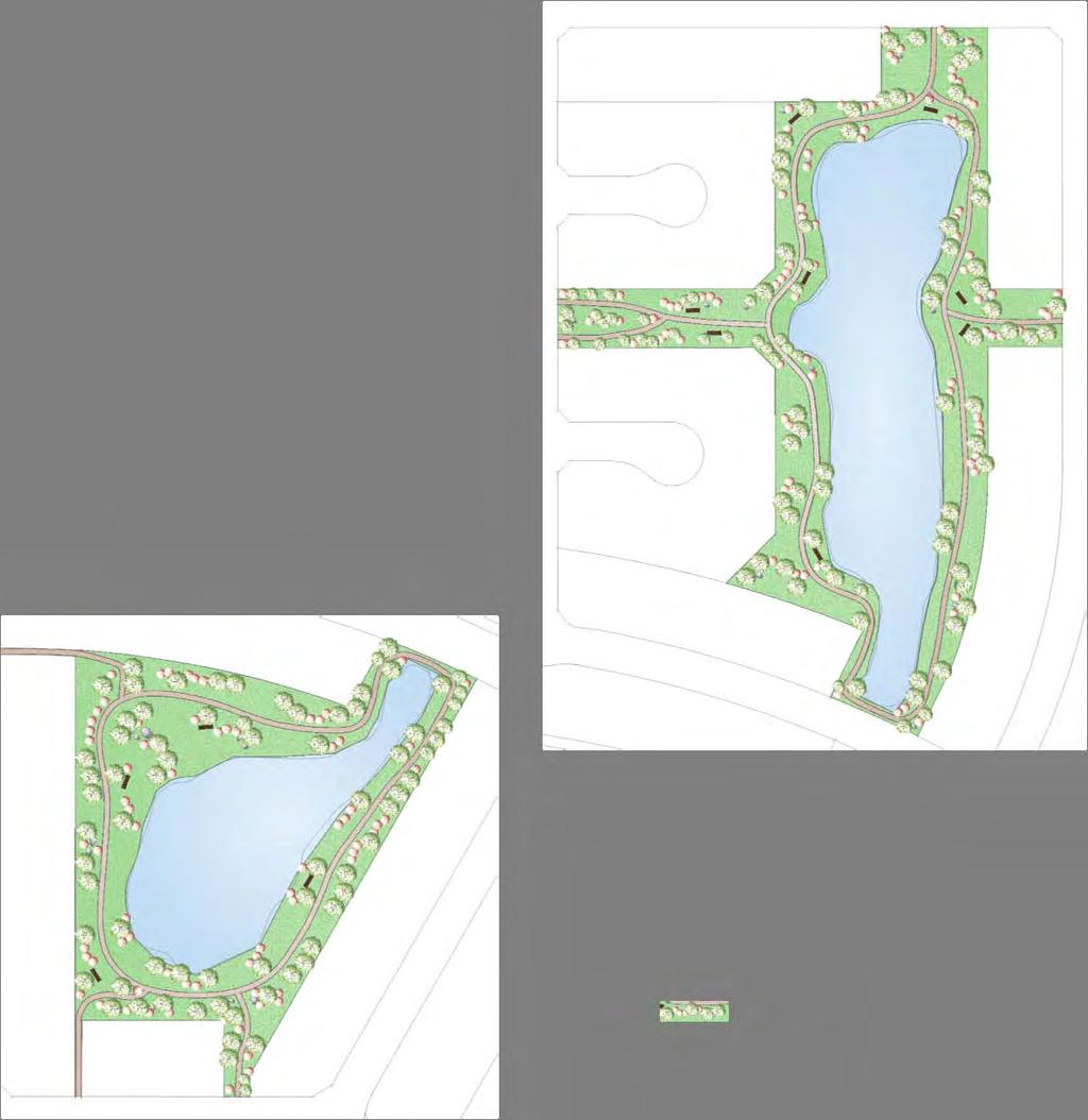

24
25 In order to accommodate the Regional Pathway which runs through the community, an additional 5m has been added to the cross section of the east/west collector to provide a landscaped boulevard with a 2.5m paved asphalt pathway that can accommodate both pedestrian and bicycle traffic separated from vehicular movement. The MR dedicated provides: Two larger parcels of sufficient size to provide playground and sports facilities in the southern portion of the Plan; Two rectangular spaces that provide a view through the residential area to the aerated ponds to the east and toward the mountains to the west, in the northern portion of the Plan, creating an inviting entry into the community cells as well as a pleasant open linear pathway space; Open space around the stormwater ponds to create a natural landscaped area for walking, observing, and experiencing nature; and, Smaller linear spaces strategically located to provide linkages to the commercial and future school site as well as to provide visual access from the roadway system. 5.0 TRANSPORTATION Each phase is serviced with roadways that form cul-de-sacs and relatively short crescents providing ease of access, emergency egress/ingress, quiet streets, reduced vehicular speeds, and a sense of security. 5.1 Road Network The road system has been designed to create a safe and efficient movement of vehicles and non vehicular traffic through the community (Figure 8.0 Transportation Network). A hierarchy of roads from arterial, collector, and residential standards has been utilized in community design. Collector standard roads have been used to direct traffic to a potential future major thoroughfare along the north boundary and as a connector from 50 th Avenue to future residential development to the west. A median divides the primary entrance collector road at 50 th Avenue as an entry feature and for emergency vehicle access. Refer to Figures 9.0, 10.0A, and 10.0B regarding the proposed road cross sections. The collector roads effectively divide the community into four neighbourhood cells, each of which has two points of entry or egress. Within each cell the internal system forms closed circuit crescents and cul-de-sacs which provide a sense of scale relative to the adjacent residential use as well as helping to reduce speed. Land has been dedicated along the north boundary for the future construction of a major standard road. Sidewalks are provided on both sides of the collectors and on one side of the residential standard roads as part of the regional and local pathway systems. As a result of an active rail line to the east of the property, special attention will be given to the interface of development adjacent to 50 th Avenue within 100m of the centerline of the railway. This will include vibration analysis and suppression if required along with sound attenuation through various methods such as distance and/or fencing. July 2010 Page 13
26
27
28
29
30 Several methods of traffic calming measures are being introduced (Figure 9.0 Traffic Calming), these include divided roadways with medians and a roundabout. Due to the length of the straight, centrally located, north/south (Collector) street, a roundabout is proposed for the first intersection south of the arterial road along the north boundary of the site as a traffic calming device while acting as an entry feature to the neighbourhood. In addition, a temporary four way stop is proposed at the following intersection (further south) on the north/south (Collector) street to further assist in traffic calming. Policy Access to the subdivision shall be generally in accordance with Figure 8.0 Transportation Network. Policy Policy The site both during and after full development will provide and maintain appropriate emergency vehicle access, to the satisfaction of the Town of Olds. Complete road systems shall be constructed by the Developer to the satisfaction of the Town of Olds. Policy Cost sharing and/or Endeavours to Assist will be considered where oversized infrastructure is provided beyond what is required for the development, at the sole discretion of Council to assign. Policy Policy Policy New roads and driveways connecting onto Range Road 14 shall not be constructed until suitable arrangements have been made in writing with Mountain View County and/or arrangements have been made between the Town and County to transfer management responsibilities and control over the affected segment of Range Road 14. Noise attenuation features shall be provided along the length of the major road shown on Figure 8.0 Transportation Network to the satisfaction of the Town. No definitive alignment has been chosen, however, potential Functional Alignments for the extension of Highway 27 to the north of the Town of Olds may impact the Plan Area, particularly in identified development phases four (4), five (5), and six (6). The Developer shall protect right-ofway for future alignments for the benefit of Alberta Transportation within Phases four (4), five (5), and six (6) in the event that the preferred Highway 27 re-alignment is directed toward and within the Plan Area. Should a definitive alignment be chosen by Alberta Transportation that impacts the Plan Area, subsequent review and amendment to this area structure plan shall be required. July 2010 Page 14
31 6.0 UTILITIES AND SERVICING 6.1 Water Supply and Conservation Water servicing for the area is currently under review and analysis. In discussions with Town staff, there is both an interim plan and an ultimate solution (Figure 11.0 Preliminary Water Design). On a short term basis, water servicing is available from 50 th Avenue; the ultimate tiein will be to the 300mm water main currently underway on the east side of the railway. 6.2 Sanitary Wastewater To accommodate the development of this Plan Area, a sanitary lift station is required where it is intended to connect to the regional forcemain proposed approximately one mile to the north. This lift station is proposed to be located in the northeast corner of the site (Figure 12.0 Preliminary Wastewater Design). However, in the event that the regional forcemain has not been installed at the time of design, the Developer is prepared to install a temporary holding tank where the sewage will be transported to a licensed receiving location. During the initial stages of development a temporary holding tank is a feasible interim solution as the amount of contribution to sewage volumes is relatively low as occupancies within the development do not occur immediately but rather a minimum of eight (8) months after construction of the infrastructure is completed. It is anticipated that sanitary sewer trunk lines will, for the most part, be accommodated within the rights-of way of major roads. Similarly, the sanitary servicing proposal will be presented to the Town as part of the overall discussions related to providing services to the Plan Area. 6.3 Stormwater Management Existing site drainage occurs from the entire Plan Area along the roadside ditch along 50 th Avenue. This ditch also collects post-development runoff from a portion of the Town of Olds. The ditch drainage boundary includes the land north of the main road (Highway 27) west of 50 th Avenue and the discharge from the dry pond constructed for the Sierra development. The 100 year pre-development peak flow from the study area was determined as 468L/s/ha using the SWMHYMO model. The storm water management system is intended to: Contain the 1:100 storm event; Provide a method to deal with the drainage to the south and along 50 th Avenue; Improve water quality prior to discharge; and, Discharge at or below predevelopment flow rates. The proposed Discovery Plains development will discharge its post-development runoff to the existing ditch (along 50 th Avenue) in the NE corner of the Plan Area. The maximum allowable rate of discharge during a 100 year storm was assumed at 220L/s, or 3.7L/s/ha, less than 50% of the calculated pre-development peak flow. The runoff generated in the majority of the Plan Area (and offsite to the north and west) for a total area of 58.88ha (145.49ac) will be collected July 2010 Page 15
32
33
34 in two interconnected stormwater ponds. The upstream, South Pond, will collect the runoff from 28.36ha (57.72ac) and its maximum discharge rate has been determined at 132L/s or 4.7L/S/ha. The discharge from the South Pond will be controlled and will enter the Main Pond through a 600mm connecting pipe. The Main Pond will receive runoff from the north catchment area of 30.52ha (75.41ac), and the inflow from the South Pond, reducing the total discharge to 220L/s (Figure 13.0 Preliminary Stormwater Design). The proposed ponds consist of permanent section 2.5m deep which provide the water quality control and active storage sections where runoff in excess of the pre-development rate is temporarily stored. The permanent pond volume in the proposed ponds is about 22,700m 3 significantly exceeding the volume of 14,845m 3 which is based on the 250m 3 /ha requirement. The site will be modeled to meet the standards of both the Town of Olds and Alberta Environment. An alliance is in process with the Olds College to potentially expand their curriculum to include ideas for nutrient treatment and sediment control with regards to the storm ponds as well as introducing some innovative ideas when it comes to landscaping within a storm water area. It is intended that these ponds will provide a valuable amenity in the form of open space and a natural setting that attracts birds and wildlife. They will be enhanced through the use of fountains that will aerate the water reducing the amount of algae and in turn any odour that might occur from its presence. 6.4 Shallow Utilities Private utility companies will supply, install and operate the following services: gas, power, telephone, and cable. These facilities will be installed pursuant to the Town of Olds Engineering Standards and Specifications. 7.0 DEVELOPMENT STANDARDS Development standards and architectural controls will be utilized at the Development Permit stage to ensure that all new site development will be compatible with adjacent land uses. 7.1 Architectural Controls The Developer will establish architectural controls for the area in general and for the different land use designations in particular. A general theme will be established for the area and then specifically for the neighbourhood cells and particular land uses as required. Specific attention will be paid to materials, colors, and architectural detailing that enhances the elevation treatment of the home and the streetscape. It is a foundation of community planning that producing an aesthetically pleasing housing form creates a sense of pride in ownership that in turn results in care and attention being paid to the maintenance of the home by the owner. Home elevations will be approved by the Developer s Architectural Control agent before a development permit application is permitted to be submitted to the Town. July 2010 Page 16
35
36 Policy The Discovery Plains Plan Area Architectural Controls shall inform quality in the built environment and include but not be limited to materials, colors, and architectural detailing. 8.0 PUBLIC CONSULTATION A public Open House in support of the Discovery Plains Area Structure Plan process was held on June 29, A Public Open House Summary Report was submitted under a separate cover to the Town. The report summarizes comments provided during the question and answer period following the presentation, the one-on-one discussions with Project Team members, and the feedback forms received from residents. 9.0 IMPLEMENTATION, REVIEW, AND AMENDMENT 9.1 ASP Implementation The Discovery Plains Area Structure Plan falls within a hierarchy of applicable plans. The Town of Olds Municipal Development Plan (MDP) is the guiding document for all development within the municipality. The Land Use Bylaw (LUB) establishes the land use rules and regulations. The Discovery Plains ASP presents a greater level of planning detail within the specific Plan Area and is required to be consistent with both the MDP and LUB. Development in the ASP should be acceptable to community and consistent with policy contained within this document. The Discovery Plains Area Structure Plan does not supersede, repeal, replace or otherwise diminish any other statutory plan in effect in the Plan Area. Policy The policies contained within this document shall be reviewed and implemented by the Town of Olds at their discretion. 9.2 Plan Review and Amendment As the Discovery Plains Area Structure Plan is adopted by bylaw of the Municipality, a formal process as outlined in the Municipal Government Act is required to amend the Plan. July 2010 Page 17
37
OP Council Resolution June 16, Planning and Development Services
 OP-08-01 Council Resolution June 16, 2008 Planning and Development Services Kingsgate Landing Outline Plan Table of Contents 1.0 Introduction 1 1.1 Purpose of Plan 1 1.2 Plan Area Location 1 1.3 Ownership
City of Grande Prairie Development Services Department
 City of Grande Prairie Development Services Department ROYAL OAKS NORTH OUTLINE PLAN OP-07-03 NW 35-71-6 W6M May 7, 2007 Royal Oaks North Outline Plan TABLE OF CONTENTS 1.0 INTRODUCTION........ 3 1.1 Purpose
Bylaw C-1186 Adopted November 5, Planning and Development Services
 Bylaw C-1186 Adopted November 5, 2007 Planning and Development Services CITY OF GRANDE PRAIRIE OFFICE CONSOLIDATION BYLAW C-1186 A Bylaw to adopt the Westgate Area Structure Plan (As Amended by Bylaw C-1186-1,
Bylaw C-1262 Adopted February 6, Planning and Development Department
 Bylaw C-1262 Adopted February 6, 2012 Planning and Development Department CITY OF GRANDE PRAIRIE BYLAW C-1262 A Bylaw to adopt the Brookfield Neighbourhood Outline Plan THE MUNICIPAL COUNCIL OF THE CITY
City of Grande Prairie Development Services Department KENNEDY DEVELOPMENTS LTD. OUTLINE PLAN OP-09-01
 City of Grande Prairie Development Services Department KENNEDY DEVELOPMENTS LTD. OUTLINE PLAN OP-09-01 July 27, 2009 TABLE OF CONTENTS 1.0 Introduction... 1 1.1 Plan Area Location & Context... 1 1.2 Ownership
Palisades Outline Plan
 NE ¼ 25 36 28 W4 Town of Penhold Approved August 13, 2012 Contents Figures & Tables... 2 Introduction... 1 Overview... 1 Purpose... 1 Development Area... 3 Ownership... 3 Topography... 3 Existing & Surrounding
Red Fox Commercial Outline Plan
 Red Fox Commercial Outline Plan City of Cold Lake, Alberta Prepared by Durrance Projects Ltd and Ross W. Sharp & Associates Ltd October 2014 Rupert 1 Table of Contents 1. PURPOSE...3 1.1. Location...4
Bylaw No. B-03/2011 Adopted by Airdrie City Council February 21, 2012
 COOPER S CROSSING STAGE 4 Neighbourhood Structure Plan City of Airdrie WESTMARK HOLDINGS LTD. Bylaw No. B-03/2011 Adopted by Airdrie City Council February 21, 2012 CONSULTANTS: LAND USE PLANNING: Southwell
Westwind Developments Ltd. PIONEER LANDS AREA STRUCTURE PLAN - PROPOSED AMENDMENT
 FEBRUARY 2013 TABLE OF CONTENTS 1.0 BACKGROUND... 1 1.1 Amendment... 1 2.0 LOCATION & CONTEXT... 2 2.1 Land Ownership... 2 3.0 POLICY CONTEXT... 3 3.1 Municipal Development Plan... 3 3.2 Capital Region
TABLE OF CONTENTS. Sierra Springs Outline Plan
 Sierra Springs Outline Plan TABLE OF CONTENTS 1. Introduction...3 1.1. Purpose of the Plan... 3 1.2. The Approval Process... 3 1.3. Policy and Legislative Framework... 3 2. Development Area...6 2.1. Location
LAND USE AMENDMENT CORNERSTONE (WARD 3) 60 STREET NE AND COUNTRY HILLS BOULEVARD NE MAP 26NE BYLAW 22D2017
 60 STREET NE AND COUNTRY HILLS BOULEVARD NE MAP 26NE BYLAW 22D2017") Page 1 of 14 EXECUTIVE SUMMARY This Land Use Amendment application covers an area of 43.76 hectares ± (108.14 acres ±) located in northeast Calgary, bound by Country Hills Boulevard NE to the south and
Page 1 of 14 EXECUTIVE SUMMARY This Land Use Amendment application covers an area of 43.76 hectares ± (108.14 acres ±) located in northeast Calgary, bound by Country Hills Boulevard NE to the south and
S o u t h C e n t r a l O u t l i n e P l a n. Leduc Business Park. North Leduc Industrial Area Structure Plan C it y of Led u c.
 Leduc Business Park North Leduc Industrial Area Structure Plan C it y of Led u c Prepared for Farm Air Properties Inc. January, 2007 Table of Contents Page Number 1.0 Purpose of Plan and Definition of
C ity of Grande Prairie Development Services Department
 C ity of Grande Prairie Development Services Department FAIRWAY DEVELOPMENT OUTLINE PLAN OP 08 09 Approved April 6, 2009 Prepared by: Focus Corporation Table of Contents 1.0. Introduction 2 3 1.1. Plan
WEST HILL BUSINESS PARK AREA STRUCTURE PLAN
 MUNICIPAL DISTRICT OF PEACE NO. 135 WEST HILL BUSINESS PARK AREA STRUCTURE PLAN Prepared by: TABLE OF CONTENTS 1.0 Introduction... 1 1.1 Purpose of Plan........ 1 1.2 Plan Area..... 1 1.3 Existing Conditions...
Land Use Amendment in Southwood (Ward 11) at and Elbow Drive SW, LOC
 at and Elbow Drive SW, LOC") 2018 November 15 Page 1 of 10 EXECUTIVE SUMMARY This land use amendment application was submitted by Rick Balbi Architect on 2017 August 31 on behalf of Sable Developments Ltd, and with authorization from
2018 November 15 Page 1 of 10 EXECUTIVE SUMMARY This land use amendment application was submitted by Rick Balbi Architect on 2017 August 31 on behalf of Sable Developments Ltd, and with authorization from
BYLAW C A Bylaw of Rocky View County to amend Land Use Bylaw C
 BYLAW C-7720-2017 A Bylaw of Rocky View County to amend Land Use Bylaw C-4841-97. The Council of Rocky View County enacts as follows: PART 1 TITLE This Bylaw shall be known as Bylaw C-7720-2017. PART 2
ADMINISTRATION RECOMMENDATION 2016 November 03. That Calgary Planning Commission recommends APPROVAL of the proposed Land Use Amendment.
 Page 1 of 12 EXECUTIVE SUMMARY This Land Use Amendment application covers an area of 75.76 hectares ± (187.20 acres ±) located in northeast Calgary, bound by Stoney Trail NE to the north, 128 Avenue NE
HAMLET OF KINGMAN AREA STRUCTURE PLAN
 HAMLET OF KINGMAN AREA STRUCTURE PLAN Prepared by: Austrom Consulting Ltd. Page 1 of 19 Table of Contents TABLE OF CONTENTS... 2 1. BACKGROUND... 3 1.1 PLAN AREA... 3 1.2 PLAN PURPOSE... 3 1.3 LEGISLATIVE
Outline Plan in Belvedere (Ward 9) at Street SE, LOC (OP)
 at Street SE, LOC (OP)") 2018 October 04 Page 1 of 12 EXECUTIVE SUMMARY This outline plan application was submitted by B&A Planning Group on 2016 July 15, on behalf of Tristar Communities Inc. for 50.14 hectares (123.89 acres)
2018 October 04 Page 1 of 12 EXECUTIVE SUMMARY This outline plan application was submitted by B&A Planning Group on 2016 July 15, on behalf of Tristar Communities Inc. for 50.14 hectares (123.89 acres)
Area Structure Plan. A Community for All Seasons. Prepared for the Town of Strathmore. Consolidated September 28, 2015
 Area Structure Plan Prepared for the Town of Strathmore A Community for All Seasons Lakewood Meadows Area Structure Plan Prepared for the Town of Strathmore And Lakewood Meadows Inc. i Table of Contents
Leduc Industrial Outline Plan SE W4
 Leduc Industrial Outline Plan SE 1-50-25-W4 Within the North Leduc Industrial ASP Prepared for: Leduc Energy Park Ltd. Prepared by: Stantec Consulting Ltd. File No. 1161 104655 V5 Table of Contents 1.0
LAND USE AMENDMENT CORNERSTONE (WARD 3) COUNTRY HILLS BOULEVARD AND STONEY TRAIL NE BYLAW 9D2017
 COUNTRY HILLS BOULEVARD AND STONEY TRAIL NE BYLAW 9D2017") Page 1 of 12 EXECUTIVE SUMMARY This Land Use Amendment application covers an area of 54.92 hectares ± (135.71 acres ±) located in northeast Calgary, bound by Country Hills Boulevard NE to the north and
Page 1 of 12 EXECUTIVE SUMMARY This Land Use Amendment application covers an area of 54.92 hectares ± (135.71 acres ±) located in northeast Calgary, bound by Country Hills Boulevard NE to the north and
Municipal Development Plan. Summer Village of ROCHON SANDS. Bylaw #241-18
 Municipal Development Plan Summer Village of ROCHON SANDS Bylaw #241-18 TABLE OF CONTENTS PART ONE: BACKGROUND AND PURPOSE 3 SECTION 1: BACKGROUND 3 SECTION 2: GOALS AND POLICIES 3 PART TWO: PHYSICAL ENVIRONMENT
ROAD CLOSURE AND LAND USE AMENDMENT SILVER SPRINGS (WARD 1) NORTHEAST OF NOSEHILL DRIVE NW AND SILVER SPRINGS ROAD NW BYLAWS 2C2018 AND 29D2018
 NORTHEAST OF NOSEHILL DRIVE NW AND SILVER SPRINGS ROAD NW BYLAWS 2C2018 AND 29D2018") Page 1 of 19 EXECUTIVE SUMMARY This application proposes redesignating two parcels in the community of Silver Springs from Special Purpose Future Urban Development (S-FUD) District and undesignated road
Page 1 of 19 EXECUTIVE SUMMARY This application proposes redesignating two parcels in the community of Silver Springs from Special Purpose Future Urban Development (S-FUD) District and undesignated road
Gold Line Bus Rapid Transit Transit Oriented Development (BRTOD) Helmo Station Area Plan
 Helmo Station Area Plan") Appendix F Gold Line Bus Rapid Transit Transit Oriented Development (BRTOD) Helmo Station Area Plan Introduction and Purpose of the Plan The Gold Line Bus Rapid Transit facility is an eleven-mile dedicated
Appendix F Gold Line Bus Rapid Transit Transit Oriented Development (BRTOD) Helmo Station Area Plan Introduction and Purpose of the Plan The Gold Line Bus Rapid Transit facility is an eleven-mile dedicated
This application has been applied for with support of an Outline Plan to provide the technical details for the site s development.
 Page 1 of 13 EXECUTIVE SUMMARY This application consists of a Land Use Amendment application proposing redesignation from Special Purpose Future Urban Development (S-FUD) District to an assortment of multiresidential,
ADMINISTRATION RECOMMENDATION(S) 2017 February 09. That Calgary Planning Commission recommends APPROVAL of the proposed Land Use Amendment.
 2017 February 09. That Calgary Planning Commission recommends APPROVAL of the proposed Land Use Amendment.") Page 1 of 10 EXECUTIVE SUMMARY This land use amendment application is to accommodate changes to the location of a stormwater retention pond and land use boundaries adjacent to Environmental Reserve in
Page 1 of 10 EXECUTIVE SUMMARY This land use amendment application is to accommodate changes to the location of a stormwater retention pond and land use boundaries adjacent to Environmental Reserve in
SANDSTONE SPRINGS AREA STRUCTURE PLAN
 Sandstone Springs Development Corp. AREA STRUCTURE PLAN This report is prepared for the sole use of Sandstone Springs Development Corp. No representations of any kind are made by Urban Systems Ltd. or
GATEWAY AREA STRUCTURE PLAN
 CHESTERMERE GATEWAY AREA STRUCTURE PLAN COMMUNITY OPEN HOUSE SEPTEMBER 22 nd, 2015 PLAN AREA ± 512 hectares (± 1,265 acres) GATEWAY LOCATION UNDEVELOPED LANDS PRESENT AGRICULTURAL USE REGIONAL LAND USE
NEIGHBORHOOD STRUCTURE PLAN
 June 19, 2006 BYLAW 05/2006 NEIGHBORHOOD STRUCTURE PLAN ADOPTED BY CITY COUNCIL June 19, 2006 BYLAW 05/2006 Prepared for: Hopewell Residential Communities Prepared by: Brown & Associates Planning Group
SUMMER VILLAGE OF SUNRISE BEACH
 SUMMER VILLAGE OF SUNRISE BEACH Municipal Development Plan Bylaw No. 132-13 ~ 2 ~ Summer Village of Sunrise Beach Municipal Development Plan 1 INTRODUCTION 1.1 SETTING The Summer Village of Sunrise Beach
North Oakville East Parks Facilities Distribution Plan. November, 2009
 North Oakville East November, 2009 POLICY CONTEXT 1) Purpose a) The purpose of this document is to be a guide for the location, configuration, design and development of the parks system for the North Oakville
Stewart Greens Neighbourhood Structure Plan
 Stewart Greens Neighbourhood Structure Plan Office Consolidation June 2017 Prepared by: Planning and Policy Services Branch Planning and Development Department City of Edmonton Bylaw 14674, as amended,
DAVENPORT VILLAGE SECONDARY PLAN
 27 DAVENPORT VILLAGE SECONDARY PLAN 27. DAVENPORT VILLAGE SECONDARY PLAN 1. VISION FOR THE DAVENPORT VILLAGE SECONDARY PLAN Davenport Village, municipally known as 830, 940, 980 and 1100 Lansdowne Avenue,
Neighborhood Districts
 NEIGHBORHOOD DISTRICTS SEVEN MAIN DISTRICTS Neighborhood Districts While the Development Plan provides a broad-scale overview of the neighborhood, this section focuses on uses and relationships at the
SYRINGA VALLEY SPECIFIC PLAN NARRATIVE
 SYRINGA VALLEY SPECIFIC PLAN NARRATIVE Introduction With this application, Pleasant Valley South LLC ( Pleasant Valley ) seeks the City of Boise s approval of a new Specific Plan Ordinance to be added
MUNICIPAL DEVELOPMENT PLAN
 MUNICIPAL DEVELOPMENT PLAN Bylaw 2007-22 Prepared by: Office Consolidation - April 2017 Table of Contents 1.0 Introduction and Purpose... 1 2.0 Community Context and Trends... 2 3.0 Vision Statement...
Central and East Neighbourhoods - Hermitage Outline Plan
 Central and East Neighbourhoods - Hermitage Outline Plan Office Consolidation September 2013 Prepared by: Planning and Policy Services Branch Planning and Development Department City of Edmonton The Central
THE CITY OF WINNIPEG BY-LAW NO. 4/2013. A By-law of THE CITY OF WINNIPEG to adopt a Secondary Plan for the Waverley West Southwest Neighbourhood.
 THE CITY OF WINNIPEG BY-LAW NO. 4/2013 A By-law of THE CITY OF WINNIPEG to adopt a Secondary Plan for the Waverley West Southwest Neighbourhood. THE CITY OF WINNIPEG, in Council assembled, enacts as follows:
Mayliewan Neighbourhood Structure Plan Neighbourhood 7 of the Edmonton North Area Structure Plan
 Mayliewan Neighbourhood Structure Plan Neighbourhood 7 of the Edmonton North Area Structure Plan Office Consolidation November 2008 Prepared by: Planning and Policy Services Branch Planning and Development
Prepared for: Prepared by: Revised November 2013 by Stantec Consulting Ltd. 200, th Street Se Calgary, AB, T2A 7H8
 Prepared for: Prepared by: PLANNING PROTOCOL INC. 3916 1 ST STREET N.E. CALGARY, AB. T2E 3E3 Revised November 2013 by Stantec Consulting Ltd. 200, 325 25 th Street Se Calgary, AB, T2A 7H8 Table of Contents
THE CITY OF SPRUCE GROVE BYLAW C PIONEER LANDS AREA STRUCTURE PLAN AMENDMENT
 THE CITY OF SPRUCE GROVE BYLAW C-797-11 PIONEER LANDS AREA STRUCTURE PLAN AMENDMENT WHEREAS, pursuant to the Municipal Government Act, R.S.A., 2000, c.m-26, a municipality shall adopt Area Structure Plans
FORMER CANADIAN FORCES BASE (CFB) ROCKCLIFFE SECONDARY PLAN. Official Plan Amendment XX to the Official Plan for the City of Ottawa
 ROCKCLIFFE SECONDARY PLAN. Official Plan Amendment XX to the Official Plan for the City of Ottawa") FORMER CANADIAN FORCES BASE (CFB) ROCKCLIFFE SECONDARY PLAN Official Plan Amendment XX to the Official Plan for the City of Ottawa 1 INDEX THE STATEMENT OF COMPONENTS PART A THE PREAMBLE PAGE Purpose...
FORMER CANADIAN FORCES BASE (CFB) ROCKCLIFFE SECONDARY PLAN Official Plan Amendment XX to the Official Plan for the City of Ottawa 1 INDEX THE STATEMENT OF COMPONENTS PART A THE PREAMBLE PAGE Purpose...
Planning Commission Staff Report June 5, 2008
 Owner/Applicant Taylor Village Sacramento Investments Partners, LP c/o Kim Whitney 1792 Tribute Road #270 Sacramento, CA 95815 Staff Recommendation Planning Commission Staff Report Project: File: Request:
and services The protection and conservation of environmentally significant and sensitive natural heritage features and functions.
 6. Land Use 6.0 Preamble A healthy and livable city is one in which people can enjoy a vibrant economy and a sustainable healthy environment in safe, caring and diverse neighbourhoods. In order to ensure
Mitchell Ranch South MPUD Application for Master Planned Unit Development Approval Project Narrative. Introduction
 Mitchell Ranch South MPUD Application for Master Planned Unit Development Approval Project Narrative Introduction Mitchell Ranch South is a proposed single family (detached) residential development on
ADMINISTRATION RECOMMENDATION(S) 2017 June 15. That Calgary Planning Commission recommends APPROVAL of the proposed Land Use Amendment.
 2017 June 15. That Calgary Planning Commission recommends APPROVAL of the proposed Land Use Amendment.") Page 1 of 7 EXECUTIVE SUMMARY The proposed land use amendment seeks to redesignate a Special Purpose Future Urban Development (S-FUD) District parcel in Residual Ward 3 Sub Area 3H to Industrial Outdoor
Page 1 of 7 EXECUTIVE SUMMARY The proposed land use amendment seeks to redesignate a Special Purpose Future Urban Development (S-FUD) District parcel in Residual Ward 3 Sub Area 3H to Industrial Outdoor
Official Plan Review
 Official Plan Review Summary Report - The Built Environment August 2014 Part 1: Introduction Planning for a healthy, prosperous and sustainable community is an important goal for our municipality. From
HAMPTONS Area Structure Plan Medicine Hat, Alberta
 HAMPTONS Medicine Hat, Alberta Prepared for: Lansdowne Equity Ventures Ltd. Prepared by: UMA Engineering Ltd. May 2005 Table of Contents Page No. 1. INTRODUCTION...1 1.1 Purpose...1 1.2 Location & Existing
Sewanee Village + Request for Builder/Developer Proposals
 Sewanee Village + Request for Builder/Developer Proposals Contact: Frank X. Gladu Special Assistant to the Vice Chancellor University of the South 735 University Ave Version 3 Sewanee TN 37383 Released:
URBAN DESIGN BRIEF URBAN DESIGN BRIEF 721 FRANKLIN BLVD, CAMBRIDGE August 2018
 URBAN DESIGN BRIEF URBAN DESIGN BRIEF 721 FRANKLIN BLVD, CAMBRIDGE August 2018 DESIGN BRIEF CONTENTS PART A 1.0 INTRODUCTION 2.0 DESCRIPTION & ANALYSIS OF SITE CONTEXT 3.0 DESIGN CONSTRAINTS AND OPPORTUNITIES
The West Vaughan Employment Area Secondary Plan Policies
 Part 2: The West Vaughan Employment Area Secondary Plan Policies 2.1 General Policies It is the policy of Council: 2.1.1. That the West Vaughan Employment Area (the WVEA), identified on Schedule 1, will
Bylaw 884/13 Schedule A. Town of Rimbey. June 2008.
 Bylaw 884/13 Schedule A Town of Rimbey June 2008. Revised April 2013 Bylaw 884/13 Schedule A Johnson Estates Table of Contents 1. Introduction... 11 1.1 Purpose... 11 1.2 Location Context... 11 1.3 Land
GRAYSTONE ESTATES CONCEPTUAL SCHEME
 GRAYSTONE ESTATES CONCEPTUAL SCHEME Bylaw C-5438-2001, Adopted November 6, 2001 MUNICIPAL DISTRICT OF ROCKY VIEW NO. 44 Department of Planning and Development TABLE OF CONTENTS 1.0 INTRODUCTION 5 1.1 Conceptual
PORT WHITBY COMMUNITY
 PORT WHITBY COMMUNITY SECONDARY PLAN UPDATE COMMUNITY IMPROVEMENT PLAN URBAN DESIGN GUIDELINES September 2015 DRAFT PROPOSED AMENDMENT NUMBER # to the Whitby Official Plan PURPOSE: The intent of this Amendment
ARTICLE 6: Special and Planned Development Districts
 ARTICLE 6: Special and Planned Development Districts 6-10 Traditional Neighborhood Development (TND) District 6-10.10 Purpose and Intent The Traditional Neighborhood Development (TND) District provides
Ebbers Neighbourhood Area Structure Plan
 Ebbers Neighbourhood Area Structure Plan Office Consolidation November 2016 Prepared by: City Planning Branch Sustainable Development City of Edmonton Bylaw 14079, was adopted by Council in February 2006.
Town of Portola Valley General Plan. Nathhorst Triangle Area Plan
 Town of Portola Valley General Plan Amended December 10, 1997 Table of Contents Introduction... 1 Planning Area... 1 Objectives... 2 Principles... 2 Standards... 4 Description... 4 Community Commercial...
ADMINISTRATION RECOMMENDATION(S) 2018 January 25. That Calgary Planning Commission recommend APPROVAL of the proposed Land Use Amendment.
 2018 January 25. That Calgary Planning Commission recommend APPROVAL of the proposed Land Use Amendment.") Page 1 of 9 EXECUTIVE SUMMARY This land use amendment proposes to redesignate a parcel from DC Direct Control District to Multi-Residential Contextual Grade-Oriented (M-CG) District to allow for multi-residential
Page 1 of 9 EXECUTIVE SUMMARY This land use amendment proposes to redesignate a parcel from DC Direct Control District to Multi-Residential Contextual Grade-Oriented (M-CG) District to allow for multi-residential
PLANNING COMMISSION. Submitted
 PLANNING COMMISSION City Hall 1275 Main Street El Centro, CA 92243 Submitted PLANNING COMMISSION ACTION ITEM (1844) Meeting: 05/10/16 12:00 AM Department: Community Development Category: Public Hearing
AREASTRUCTURE PLAN AMENDMENT COCHRANE NORTH
 AREASTRUCTURE PLAN AMENDMENT COCHRANE NORTH In order to implement the vision outlined in the Conceptual Scheme, the following three amendments to the Cochrane North ASP are proposed: 1. Allow commercial
The Uplands Area Structure Plan. City of Cold Lake, NE & SE W4
 City of Cold Lake, NE & SE 13-63-2-W4 July 2009 1 Contents 1 Background information... 1 1.1 Foreword... 1 1.2 Purpose... 1 1.3 Plan Area and Location... 1 1.4 Ownership... 2 2 Factors Influencing Development...
Derry Green Corporate Business Park
 Town of Milton Derry Green Corporate Business Park Urban Design Guidelines BMI/Pace - June 2010 Draft 3 Prepared by: Brook McIlroy Planning + Urban Design / Pace Architects Suite 300-51 Camden Street Toronto,
4.1.3 LAND USE CATEGORIES
 4.1.3 LAND USE CATEGORIES a. City Center District The City Center District incorporates the existing character and mix of uses in downtown Belmont to encourage redevelopment and new development in keeping
A Growing Community Rural Settlement Areas
 Town of Huntsville Official Plan Review - POLICY BACKGROUND PAPER A Growing Community Rural Settlement Areas BACKGROUND: In addition to the fully municipally-serviced Urban Settlement Area and the Hidden
Table of Contents PART 1 FRAMEWORK... 1
 Table of Contents PART 1 FRAMEWORK... 1 1.0 PURPOSE... 1 1.1 MUNICIPAL GOVERNMENT ACT... 1 1.2 REGIONAL & MUNICIPAL POLICIES... 2 1.3 COMMUNITY CONTEXT... 6 PART 2 VISION... 8 2.1 SUSTAINABILITY... 8 2.2
City of Spruce Grove East Campsite Business Park Area Structure Plan
 City of Spruce Grove East Campsite Business Park Area Structure Plan Prepared by: UMA Engineering Ltd. 17007 107 Avenue Edmonton, AB T5S 1G3 T 780.486.7000 F 780.486.7070 www.uma.aecom.com Job No. 1560
Request for Decision. Recommendation. Presented: Monday, Jul 07, Report Date Friday, Jun 20, Type: Public Hearings
 Presented To: Planning Committee Request for Decision Application for rezoning in order to permit a place of worship on a vacant lot zoned for C1, Local Commercial uses, Cam Street, Sudbury Sitiri Investments
THE CITY OF SPRUCE GROVE BYLAW C PIONEER LANDS AREA STRUCTURE PLAN AMENDMENT
 THE CITY OF SPRUCE GROVE BYLAW C-932-15 PIONEER LANDS AREA STRUCTURE PLAN AMENDMENT WHEREAS, pursuant to the Municipal Government Act, R.S.A. 2000, c. M-26, including amendments, a municipality may adopt
RESIDENTIAL PLANNED UNIT DEVELOPMENT / SUBDIVISION AND REZONING CONCEPT AND DEVELOPMENT STAGE PLAN SUBMITTAL NARRATIVE
 RESIDENTIAL PLANNED UNIT DEVELOPMENT / SUBDIVISION AND REZONING CONCEPT AND DEVELOPMENT STAGE PLAN SUBMITTAL NARRATIVE DEVELOPMENT TEAM DONEGAL SOUTH Maple Grove, Minnesota March 27, 2017 Applicant/Developer/Builder:
II. SINGLE FAMILY RESIDENTIAL
 II. SINGLE FAMILY RESIDENTIAL Castle Rock is made up of numerous individually built houses and subdivision tracts that have been developed during the past century. Some of the tracts are diverse in architectural
Section 9 NEIGHBORHOOD DESIGN
 Section 9 NEIGHBORHOOD DESIGN City of Lancaster Comprehensive Plan D u n k i n, S e f k o & A s s o c i a t e s, I n c. NEIGHBORHOOD DESIGN INTRODUCTION There are many ways in which a neighborhood can
BROOKHILL NEIGHBORHOOD MODEL ZONING MAP AMENDMENT PREFACE TO APPLICATION
 BROOKHILL NEIGHBORHOOD MODEL ZONING MAP AMENDMENT PREFACE TO APPLICATION June 15, 2015 Revised: August 1, 2016 I. VISION Brookhill is a proposed community based upon the principles of Albemarle County
PLANNING JUSTIFICATION REPORT
 PLANNING JUSTIFICATION REPORT 55 DELHI STREET CITY OF GUELPH PREPARED FOR: VESTERRA PROPERTY MANAGEMENT PREPARED BY: LABRECHE PATTERSON & ASSOCIATES INC. SCOTT PATTERSON, BA, CPT, MCIP, RPP PRINCIPAL,
TOWN OF BRUDERHEIM Report to the capital region board
 TOWN OF BRUDERHEIM Report to the capital region board Introduction to the Town of Bruderheim Municipal Development Plan amendment and Relation to the CRB Evaluation Criteria 02 march 2017 1 Introduction
5.0 Community Design Plan
 5.0 Community Design Plan The Community Design Plan for the Mer Bleue area is a composite of three plans: Land Use Plan Transportation Plan Municipal Servicing Plan Read together, these Plans and associated
Transportation. Strategies for Action
 Transportation A major priority for the Overlake Neighborhood is to develop a multimodal transportation system. To achieve this system, a balance has to be found among travel, circulation and access needs;
ADMINISTRATION RECOMMENDATION(S) 2016 November 03. That Calgary Planning Commission recommends APPROVAL of the proposed Land Use Amendment.
 2016 November 03. That Calgary Planning Commission recommends APPROVAL of the proposed Land Use Amendment.") Page 1 of 7 EXECUTIVE SUMMARY This Land Use Amendment application seeks to redesignate a portion of the parcel from Industrial General (I-G) District to Special Purpose City and Regional Infrastructure
Page 1 of 7 EXECUTIVE SUMMARY This Land Use Amendment application seeks to redesignate a portion of the parcel from Industrial General (I-G) District to Special Purpose City and Regional Infrastructure
Chappelle Neighbourhood Area Structure Plan
 Chappelle Neighbourhood Area Structure Plan Office Consolidation September 2017 Prepared by: City Planning Urban Form and Corporate Strategic Development City of Edmonton Bylaw 14779 was adopted by Council
Municipal Development Plan 2013
 UNIQUELY STONY PLAIN: Municipal Development Plan 2013 Quick Reference Guide What is a Municipal Development Plan (MDP)? The Town s highest-level planning document Sets the long-term vision and key themes
DRAFT Northeast Quadrant of Kipling Avenue and Highway 7 DRAFT AUGUST 29, Goals Land Use. The goals of this Plan are to:
 AUGUST 29, 2017 12.15 Northeast Quadrant of Kipling Avenue and Highway 7 12.15.1 Goals 12.15.2 Land Use The goals of this Plan are to: 12.15.2.1 General Provisions: a) Ensure the development of a compact
Description of Preferred Alternative
 Chapter 2 Description of Preferred Alternative 2.1 Introduction This chapter of the programmatic Sammamish Town Center Sub-area Plan Final EIS provides a more detailed description of the Preferred Alternative
THE CITY OF WINNIPEG BY-LAW NO. 97/2014
 THE CITY OF WINNIPEG BY-LAW NO. 97/2014 A By-law of THE CITY OF WINNIPEG to adopt a secondary plan for Precinct E of the Complete Communities Direction Strategy By-law No. 68/2010. THE CITY OF WINNIPEG,
Urban Design Brief December 23, 2015 Southside Construction Group Official Plan & Zoning By-Law Amendment
 Urban Design Brief Proposed Official Plan & Zoning By-Law Amendment 3244, 3263 and 3274 Wonderland Road South Southside Group December 23, 2015 TABLE OF CONTENTS Page No. INTRODUCTION... 1 SECTION 1 LAND
OPEN HOUSE. Future. Neighborhood. Thursday April 27, :30 8:30 PM Refreshments provided Discovery Center, 4444 Hadley Avenue North
 OPEN HOUSE Thursday April 27, 2017 6:30 8:30 PM Refreshments provided Discovery Center, 4444 Hadley Avenue North The City Council has ini ated a planning process to guide future development on 206 acres
APPLICATION BRIEFING Prepared For: Submitted by: Date: Subject:
 Planning & Development APPLICATION BRIEFING Prepared For: Submitted by: Date: Subject: Planning Advisory Committee Jason Fox, Director of Planning & Development Development Agreement application by Godfrey
OFFICE CONSOLIDATION SECONDARY PLAN AREA 22 THE BRAMALEA SOUTH INDUSTRIAL SECONDARY PLAN
 OFFICE CONSOLIDATION SECONDARY PLAN AREA 22 THE BRAMALEA SOUTH INDUSTRIAL SECONDARY PLAN November 2010 EXPLANATORY NOTES (Secondary Plan Area 22) General (pertaining to all secondary plan office consolidations)
Planning & Development. Background. Subject Lands
 Planning & Development APPLICATION BRIEFING Prepared For: Planning Advisory Committee Submitted by: Jason Fox, Director of Planning & Development Date: Subject: Development Agreement Application by Brentwood
MAYFIELD WEST SECONDARY PLAN PHASE 2
 MAYFIELD WEST SECONDARY PLAN PHASE 2 Public Open House #3 February 25, 2010 Draft Preferred Land Use Scenario TOWN OF CALEDON PLANNING & DEVELOPMENT DEPARTMENT Open House Agenda TOWN OF CALEDON 1. Welcome
KANATA CENTRUM 255 KANATA AVENUE OFFICIAL PLAN AMENDMENT ZONING BY-LAW AMENDMENT
 KANATA CENTRUM 255 KANATA AVENUE OFFICIAL PLAN AMENDMENT ZONING BY-LAW AMENDMENT JUNE 2015 PREPARED BY: FOTENN Consultants Inc. 223 Mcleod Street Ottawa, ON K2P OZ8 (613) 730-5709 PREPARED FOR: Kanata
9 CITY OF VAUGHAN OFFICIAL PLAN AMENDMENT NO BOCA EAST INVESTMENTS LIMITED
 9 CITY OF VAUGHAN OFFICIAL PLAN AMENDMENT NO. 631 - BOCA EAST INVESTMENTS LIMITED The Planning and Economic Development Committee recommends the adoption of the recommendations contained in the following
SUNSET RIDGE - HARVEST VIEW SUSTAINABLE NEIGHBOURHOOD PLAN
 SUNSET RIDGE - HARVEST VIEW SUSTAINABLE NEIGHBOURHOOD PLAN November 2008 SUNSET RIDGE - HARVEST VIEW SUSTAINABLE NEIGHBOURHOOD PLAN This document outlines Dawson Creek s first official sustainable neighbourhood
Asbury Chapel Subdivision Sketch Plan
 Asbury Chapel Subdivision Sketch Plan PART 1: PROJECT SUMMARY Applicant: NVR Inc. Project Size: +/- 76.13 acres Parcel Numbers: 02101112,02116101,02116112, 02116113 Current Zoning: Transitional Residential
TABLE OF CONTENTS 1.0 INTRODUCTION GENERAL OBJECTIVES LAND USE DESIGNATIONS, OBJECTIVES AND POLICIES 4
 Schedule I- Redstone Golf Course Resort Area Sector Plan 1 TABLE OF CONTENTS 1.0 INTRODUCTION 3 2.0 GENERAL OBJECTIVES 3 3.0 LAND USE DESIGNATIONS, OBJECTIVES AND POLICIES 4 4.0 TRANSPORTATION AND ROAD
CITY COUNCIL AGENDA REPORT
 CITY COUNCIL AGENDA REPORT Subject: COUNCIL MOTION LRT ALIGNMENT REMOVAL FROM THE TRANSPORTATION MASTER PLAN On February 10, 2016 Councillor Hughes provided notice in accordance with Section 23 of Procedure
The Corporation of the TOWN OF MILTON
 Report to: From: Chair & Members of the Administration & Planning Standing Committee W.F. Mann, Director of Planning and Development Date: April 16, 2012 PD 022-12 (Z19/11) Subject: Technical Report Proposed
MILTON HEIGHTS COMMUNITY January 2006 Revised February 2015 Revised November 2015
 REVISED DRAFT MILTON HEIGHTS COMMUNITY January 2006 Revised February 2015 Revised November 2015 Urban Design Guidelines Milton Heights Landowners Group This page has been intentionally left blank. Contents
CENTRAL PARK MAJOR AREA STRUCTURE PLAN. Bylaw No. 2017/30, Adopted February 20, P a g e
 CENTRAL PARK MAJOR AREA STRUCTURE PLAN Bylaw No. 2017/30, Adopted February 20, 2018 1 P a g e Table of Contents 1.0 Introduction 4 1.1 Background 4 1.2 Purpose 4 1.3 Location 4 1.4 Planning Process 4
4-Town Comprehensive Plan DRAFT 7/30/07
 4-Town Comprehensive Plan DRAFT 7/30/07 Acknowledgements ning Committee Town of Harrisburg Norman Roof Randy Nicol Town of Martinsburg Terry Thisse Paul Kelly Town of Montague Jan Bagdanowicz Wendy Perry
BEAU VAL PARK/ BEAUMONT LAKES SOUTH Area Structure Plan
 BEAU VAL PARK/ BEAUMONT LAKES SOUTH (Parcels A/B/C/D, Plan 1912 EO, Plan 1025 KS) Prepared For: 1871368 AB Ltd. Presented By: DGE Civil Engineering Consultants 221, 9223-28 Avenue Edmonton, AB T6N 1N1