FOR SALE Bannister /- Acres Residential/Multifamily Urban Infill
|
|
|
- Bertha Phillips
- 6 years ago
- Views:
Transcription

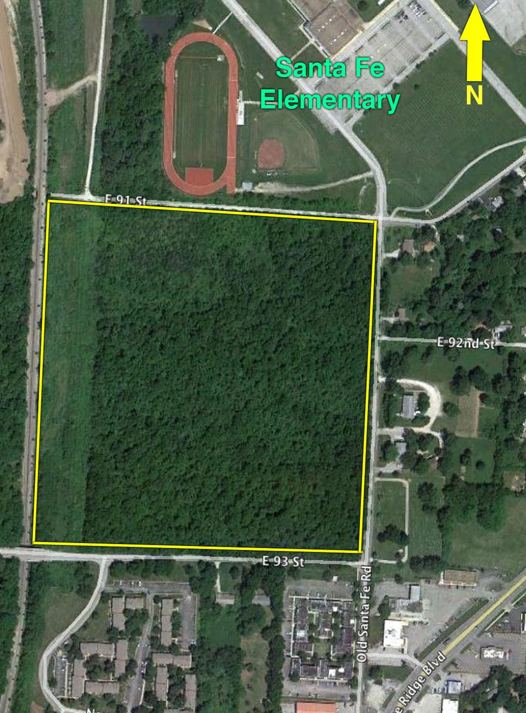
1 FOR SALE Bannister /- Acres Residential/Multifamily Urban Infill Anticipate 15,000 new employees! Adjacent to huge Bannister Urban Redevelopment area, near Cerner Innovation Campus, Oxford on the Blue Zoned R1a, Residential Low Density, for residential development up to 5.8 units/acre--potential multifamily Located on planned metro-wide Commuter Heavy Rail Corridor with potential for hub/transit station, walk/hike/bike trail Property lends itself to advanced urban planning for infill housing alternatives appealing to future generations Kevin Tubbesing TheLandSource.com The Land Source 7021 Johnson Drive Mission, KS Easily accessible from the I-435 and Bannister Road interchange Elementary school adjacent and parks are nearby for added amenities All utilities are available for development
2 Bannister /- Acres Residential/Multifamily Urban Infill Description: This appealing tract is located immediately west of a massive 350 acre Urban Redevelopment area, formerly the home of Bannister Mall and Benjamin Plaza with 2.7 million SF of retail shopping. Now planned for additional Cerner corporate offices with up to 15,000 new employees. This property and the mall sites were included in a Community Development District in 2007, which included plans for retail, offices, and an 18,000 seat soccer stadium for the Kansas City Wizards. The entire area has been cleared for urban redevelopment and ready new corporate offices. With the mass of large office buildings to the south and west, including the Cerner Innovation Campus; the 350 acre Oxford on the Blue campus for medical research; the confluence of Interstate and US Highways serving the area; the potential for urban mass transit utilizing the Kansas City Southern rail line, and planned passenger hub stations; and the exciting Three Trails walk/bike/hike system-- there is strong potential for significant re-birth of the entire area. The site itself is a quarter mile north of Bannister Road, just off Blue Ridge Boulevard. It is wellforested, and slopes downward from the north and south to a natural drainage way near the center of the property. The fairly uniformly-sloping site grades should promote attractive residential settings. A Kansas City Southern rail line runs along the west property line some thirty feet below most site elevations. This line is a key component to a planned metro-wide commuter heavy-rail transit system, which will likely include a passenger hub station nearby. There is a 100 wide overhead electrical power line easement running along the west property line. The Bannister/I-435 hub is ripe for redevelopment as a nationally prominent bioscience corridor. This prime residential tract, with attractive, rolling terrain and a great utility base, is perfectly positioned to be a new-housing component. Zoning: R1a Anticipated Zoning: City of Kansas City, Missouri, Residential Low Density, for up to 5.8 dwelling units per acre. It is included in the long range Hickman Mills Area Plan and shown as a Conservation District which allows greater flexibility in site layout, combining higher densities in exchange for more open space. City of Kansas City, Traffic & Access: 93rd Street and Old Santa Fe Road are local, two-lane asphalt-paved streets. Site development would require an up-grade of each street. 91st Street is not paved and exists only as a public rightof-way. City of, The property is easily accessible from I-435 at the Bannister Road interchange, east to Blue Ridge Boulevard, and north to Old Santa Fe Road. Both 93rd Street and Bannister Road directly link the tract to the Urban Redevelopment district. 91st Street, when improved, would do the same. Utilities: Sanitary Sewer: interceptor crosses the northerly part of the site. City of,
3 Water: Gas: 24 line runs along the west side of Old Santa Fe Road, adjacent to the property. It can be tapped for subdivision and/or heavier improvements. An 8 line is stubbed to the SW corner of 93rd and Old Santa Fe, across 93rd Street. City of Kansas City, MO, (816) line runs along the east side of Old Santa Fe Road, across the street. Missouri Gas Energy, (816) Electricity: Kansas City Power & Light, (816) Storm Water: Communications: City of Kansas City
4 Listing Price $448,000 SqFt 1,393,920 ($0.32) Location Description Location & Use Information Acres Parcel Number Specials ($14,000) Address (if assigned) Planned Use 93rd St. Santa Fe Longitude Latitude Nearest Cross Streets & Taxes 2013: $2, School Info Hickman Mills C-1 School District, Santa Fe Elementary is adjacent to the site. DOWNLOAD DETAILED DEMOGRAPHICS AND AVAILABLE SITE INFORMATION FOR THIS PROPERTY AT: Contact your Broker/Agent at The Land Source for more information Kevin Tubbesing All information furnished regarding property for sale or lease is from sources deemed reliable, but no warranty or representation is made as to the accuracy thereof, and the same is submitted subject to errors, omissions, changes of prices, rental or other conditions, prior sale or lease or withdrawal without notice.

5
Gold Line Bus Rapid Transit Transit Oriented Development (BRTOD) Helmo Station Area Plan
 Helmo Station Area Plan") Appendix F Gold Line Bus Rapid Transit Transit Oriented Development (BRTOD) Helmo Station Area Plan Introduction and Purpose of the Plan The Gold Line Bus Rapid Transit facility is an eleven-mile dedicated
Appendix F Gold Line Bus Rapid Transit Transit Oriented Development (BRTOD) Helmo Station Area Plan Introduction and Purpose of the Plan The Gold Line Bus Rapid Transit facility is an eleven-mile dedicated
BUILDER LOTS FOR SALE
 BUILDER LOTS FOR SALE NORTHERN CULPEPER - 135 ACRES RESIDENTIAL DEVELOPMENT 1256 Old Bridge Road, Amissville, VA 20106 SALE PRICE: $995,000 LOT SIZE: 135+ Acres APN #: Tax Map 2 Parcel 23 ZONING: R-1 ACCESS:
BOULEVARD AND PARKWAY STANDARDS
 88-323 BOULEVARD AND PARKWAY STANDARDS 88-323-01 PURPOSE Considerable public and private investment exists and is expected to occur adjacent to boulevards and parkways within the city. The following standards
Sub Area 2: Downtown Overland Park
 Downtown 132 2.12 encompasses over 600 acres and extends between 71st Street and 87 th Street including Downtown Overland Park. The area is home to several individual historic sites and structures, including
TEN MILE & FRANKLIN LAND 39± ACRES 2954 WEST FRANKLIN ROAD MERIDIAN, ID
 PROPERTY INMATION HIGHLIGHTS Property Type: Land»» Access points: Three commercial access points on Ten Mile Land Size: 38.99 Acres Parcel: S1211336065 Zoning: RUT: Rural Urban Transition Future Zoning:
SUNSET CORRIDOR LAND. The property is now available and ready for corporate utilization, development or investment.
 SUNSET CORRIDOR LAND The property is now available and ready for corporate utilization, development or investment. This 275-acre site is now available and ready to develop. Just off US 26, this west Sunset
RESIDENTIAL PLANNED UNIT DEVELOPMENT / SUBDIVISION AND REZONING CONCEPT AND DEVELOPMENT STAGE PLAN SUBMITTAL NARRATIVE
 RESIDENTIAL PLANNED UNIT DEVELOPMENT / SUBDIVISION AND REZONING CONCEPT AND DEVELOPMENT STAGE PLAN SUBMITTAL NARRATIVE DEVELOPMENT TEAM DONEGAL SOUTH Maple Grove, Minnesota March 27, 2017 Applicant/Developer/Builder:
1.0 Circulation Element
 5/9/18 1.0 Circulation Element 1.1 Introduction As growth and development occur in Apache County, enhancements to its circulation system will be necessary. With time, more roads will be paved and air and
Micco Park Village Development
 FOR SALE Call For Pricing Micco Park Village Development Proposed Project Property Details Micco Park Village Development PRICE Call For Pricing A monumental development opportunity of a lifetime! The
Retail-Office Space For Lease
 Retail-Office Space For Lease 200-204 North Fifth Street, Mebane, NC Pedro J. Carreño Infinito Real Estate Group, L.L.C. pc@infinitoresources.com P.O. Box 2366 Chapel Hill, NC 27515 Tel: 516-967-5294 Infinitorealestate.com
Strategic Growth Area #1 Northampton Boulevard Corridor Area
 Strategic Growth Area #1 Northampton Boulevard Corridor Area Description Strategic Growth Area #1 has established itself as a major employment center in Southside Hampton Roads. Opportunities exist to
Peppertree Business Park
 12.55 Net Acres Corporate/Institution Development Site PEPPERTREE BUSINESS PARK IS A UNIQUELY BEAUTIFUL MASTER PLANNED DEVELOPMENT SITE NESTLED AT THE FOOT OF THE SIMI HILLS WITH MEIER CREEK STREAMBED
RACER Properties in Pontiac
 RACER Properties in Pontiac Bruce Rasher, Redevelopment Manager brasher@racertrust.org Pontiac, MI Fiero Assembly Plant Pontiac North Campus Industrial Land Fiero Powerhouse 2017 Google Pontiac North Campus
Planning Districts INTRODUCTION
 INTRODUCTION To facilitate detailed examination of development prospects for all areas of the community, Delano has been divided into 14 planning districts. The location of these planning districts is
Property Profile 2954 WEST FRANKLIN ROAD MERIDIAN, ID
 082614 FOR SALE > MIXED-USE LAND Franklin & Ten Mile Land 2954 WEST FRANKLIN ROAD MERIDIAN, ID Property Profile > ~38 acres for sale, located on the NE corner of Franklin and Ten Mile > Power and gas running
SECTION 6 - LAND USE - RURAL RESIDENTIAL
 16.6.10.1 Intent The intent of the rural residential land use category is to provide low-density, single-family residential development within the Town s outer fringe. The current land is predominantly
Sam Furr and McCord Road Huntersville, North Carolina
 108± Acres of Sam Furr and McCord Road Huntersville, North Carolina NorthCross Shopping Center Land for Sale 108 Acres located in northeast Huntersville wth extensive frontage along both Sam Furr Road
Written Statement for Keizer Station Area B Amendment. Master Plan Amendment for Keizer Station Area B GENERAL INFORMATION
 Written Statement for Keizer Station Area B Amendment Applicant: City of Keizer Request: Master Plan Amendment for Keizer Station Area B DATE: June 2017 GENERAL INFORMATION A. OWNER: The City of Keizer
Major Subdivision Sketch Plan Checklist
 This checklist provides specific requirements that are apart of the Sketch process. The entire process is described by the Huntersville Subdivision Review Process which details all the submittal and resubmittal
Plan Policies. Introduction
 Plan Policies Introduction The purpose of the Plan Policies section is to identify the various Governing Body and Planning Commission land use related policy resolutions for use in evaluating development
Westbound: A One-day Exploration of Growth
 Westbound: A One-day Exploration of Growth Frog Pond Area 2018 UGB Expansion Proposal June 13, 2018 Growing Out: UGB Asks Four cities submitted proposals to expand greater Portland s urban footprint by
Mitchell Ranch South MPUD Application for Master Planned Unit Development Approval Project Narrative. Introduction
 Mitchell Ranch South MPUD Application for Master Planned Unit Development Approval Project Narrative Introduction Mitchell Ranch South is a proposed single family (detached) residential development on
October 25, Mr. Cody Riddle, Current Planning Manager Planning & Development Services City of Boise 150 N. Capitol Boulevard Boise, ID 83706
 October 25, 2016 Mr. Cody Riddle, Current Planning Manager Planning & Development Services City of Boise 150 N. Capitol Boulevard Boise, ID 83706 RE: Rush Valley East Columbia Road Annexation, Zoning and
Town Center. Block 5 Existing multifamily residential units are expected to remain.
 Area Guidelines Germantown s districts should be developed as distinct communities with unique features that are supported through the guidelines. The guidelines not only help distinguish these districts
Applicant Name Phone / Fax / Address City State Zip Code . Property Owner Phone / Fax / Address City State Zip Code
 Master Development Plan Application Community Development Department City of Redmond 411 SW 9 th Street Redmond, Oregon 97756 541-923-7721 541-548-0706 FAX Master Development Plan Fee $38,862.52 File Number
Suited for Light Industrial & Manufacturing ± 343 Acres in Denton High Traffic Counts & Visibility
 Light Industrial / Manufacturing Masch Branch & Hampton Rd Suited for Light Industrial & Manufacturing ± 343 Acres in Denton High Traffic Counts & Visibility 1400 Dallas Dr. 940.390.1927 jimmy.terrell@sbpcommercial.com
LEED-ND 101: Practical Strategies for Achieving Sustainability Goals. Travis Parker Lakewood Planning Director
 LEED-ND 101: Practical Strategies for Achieving Sustainability Goals Travis Parker Lakewood Planning Director Metro Vision Idea Exchange Oct 11, 2012 West Corridor Stations West Corridor Overview West
PARHAM & QUIOCCASIN ROADS HENRICO (RICHMOND), VA
, VA") PARHAM & QUIOCCASIN ROADS HENRICO (RICHMOND), VA THE FUTURE OF REGENCY: Endless Possibilities MALL INFORMATION Location Market Description Anchors Zoning B-3 1.5 miles south of I-64 at exit 181 in Richmond,
PARHAM & QUIOCCASIN ROADS HENRICO (RICHMOND), VA THE FUTURE OF REGENCY: Endless Possibilities MALL INFORMATION Location Market Description Anchors Zoning B-3 1.5 miles south of I-64 at exit 181 in Richmond,
A. Selma Park, Davis Bay and Wilson Creek
 A. Selma Park, Davis Bay and Wilson Creek This waterfront neighbourhood consists of three separate community areas, linked by Highway 101, but with different character, land use patterns and future potential.
2.0 AREA PLANS. Lakeside Business District. Lakeside Business District Land Use Categories:
 Lakeside Business District Lakeside Business District Land Use Categories: Campus Commercial Campus Commercial means a mixture of uses which includes corporate offices, office parks, hotels, commercial,
Central and East Neighbourhoods - Hermitage Outline Plan
 Central and East Neighbourhoods - Hermitage Outline Plan Office Consolidation September 2013 Prepared by: Planning and Policy Services Branch Planning and Development Department City of Edmonton The Central
OP Council Resolution June 16, Planning and Development Services
 OP-08-01 Council Resolution June 16, 2008 Planning and Development Services Kingsgate Landing Outline Plan Table of Contents 1.0 Introduction 1 1.1 Purpose of Plan 1 1.2 Plan Area Location 1 1.3 Ownership
Community Design Guidelines. Port Wallace DRAFT
 Community Design Guidelines Port Wallace DRAFT Energy 1 2 3 Nature Movement Connections Built Form DRAFT Layout Energy 1 Nature Community Design Guidelines GREAT COMMUNITIES PROTECT, CELEBRATE, AND CONSERVE
USA Addition of South & East Side Residential Parcels. USA Deletion of a Town of Christiana Parcel. Conversion from USA to Limited Service Area
 Village of Rockdale Village of Rockdale 148 Water Street Cambridge, WI 53523 Phone 608.423.1497 Fax 608.423.9694 Urban Service Area (USA) Amendment USA Addition of South & East Side Residential Parcels
Subarea 4 Indian Creek. Vision The combination of park networks and transportation amenities make Subarea 4 the greenest hub in the Corridor.
 indian creek 180 extends south from 101st Street to I-435. The I-435 and Metcalf intersection is one of the primary intersections in the Kansas City Metro Area. The area includes several residential neighborhoods
Welcome to Greenwood Village Corporate Capital of Colorado
 Welcome to Greenwood Village Corporate Capital of Colorado Greenwood Village Setting Incorporated: 1950 Land Area: 8.4 sq. miles + / - Budget $35M Debt $0 Reserve $20M Population Daytime: 50,000 Residents:
Floyds Fork Area Study Project Overview, Suitability Analysis, & Form Districts July 29, title
 Floyds Fork Area Study Project Overview, Suitability Analysis, & Form Districts July 29, 2008 Agenda Floyds Fork Area Study Project overview and purpose Process and schedule Ongoing initiatives Floyds
S C O P E O F W O R K A P R I L
 white flint 2 sector plan S C O P E O F W O R K A P R I L 2 0 1 2 MONTGOMERY COUNTY PLANNING DEPARTMENT M-NCPPC MontgomeryPlanning.org 1 white flint 2 sector plan Scope of Work abstract This scope of work
KCATA Transit Oriented Development Initiatives
 KCATA Transit Oriented Development Initiatives KCATA: Regional Transportation Authority Created by bi-state compact Approved by Congress 7 County service area Quasi-governmental with broad powers Power
FOR SALE: LAND Military Road Cottage Grove, MN ACRES READY FOR DEVELOPMENT! 2 PARCELS FACTS & FEATURES
 FOR SALE: LAND FACTS & FEATURES List Price: $825,000 - Will Review All Offers Residential or Mixed-Use Development Possible Potentially Up to 34 Acres Available Total Acreage - 2 Parcels: 10.72 Acres Price
City of Grande Prairie Development Services Department
 City of Grande Prairie Development Services Department ROYAL OAKS NORTH OUTLINE PLAN OP-07-03 NW 35-71-6 W6M May 7, 2007 Royal Oaks North Outline Plan TABLE OF CONTENTS 1.0 INTRODUCTION........ 3 1.1 Purpose
APPENDIX D: BACKGROUND AND VISION
 APPENDIX D: BACKGROUND AND VISION BACKGROUND A. Specific Plan Location Jordan Downs is located at 9800 Grape Street in Los Angeles, California, 90002. The Jordan Downs Urban Village Specific Plan area
13. PRELIMINARY PLAT NO MILLS FARM - Vicinity of the southeast corner of 159 th Street and Quivira Road
 13. corner of 159 th Street and Quivira Road 1. APPLICANT: HNTB Corporation is the applicant for this request. 2. REQUESTED ACTION: The applicant is requesting approval of a preliminary plat for a 383-lot
General Location Annex, Rezone & Preliminary Plat Lansdowne Addition, Unit Three
 NEWFOUNDLAND I-5 Agricultural District Subject Site SUNDANCE ANDERSON Single Family Residential CHRISTY PUD Agricultural District Highway Business General Location Annex, Rezone & Preliminary Plat Lansdowne
Staff Report and Recommendation
 Community Planning and Development Planning Services 201 W. Colfax Ave., Dept. 205 Denver, CO 80202 p: 720.865.2915 f: 720.865.3052 www.denvergov.org/cpd TO: City Council Neighborhoods and Planning Committee
Glenview - Chicago North Shore RESTAURANT/BAR FOR LEASE IN GLEN TOWN CENTER 1811 Tower Dr. Glenview, IL 60026
 Glenview - Chicago North Shore RESTAURANT/BAR FOR LEASE IN GLEN TOWN CENTER 1811 Tower Dr. Glenview, IL 60026 Demographics Population 2015 Male Population 2015 Female Population 2015 Total Population 2015
LAND USE OVERVIEW WHAT YOU WILL FIND IN THIS CHAPTER
 LAND USE WHAT YOU WILL FIND IN THIS CHAPTER Information about the City s expected population and employment growth. Description and capacity of existing and future land use designations. Policies that
Existing Conditions Assessment. August 18, 2016
 Existing Conditions Assessment August 18, 2016 1 Overview Existing Conditions Assessments 1 2 3 4 Site Conditions Land Use + Zoning Market Transportation + Parking Opportunities and Constraints 2 Site
WELCOME and introduction
 1 WELCOME and introduction Mobility Hub Locations within Burlington STUDY OVERVIEW STUDY OBJECTIVES The City of Burlington is developing four Area Specific Plans, one for each of Burlington s Mobility
PDR /21/15 Noah Beals 1/7/15 xx
 PDR150001 1/21/15 Noah Beals 1/7/15 xx 01.07.15 HTP Harmony Frontage Infrastructure Preliminary Design Review Project Narrative a) What are you proposing/use? The HTP Harmony Frontage Infrastructure project
Tyvola & Archdale Transit Station Area Plan. May 15, 2008
 Tyvola & Archdale Transit Station Area Plan First Public Meeting May 15, 2008 Presentation Outline 1. Purpose and Process 2. Station Area Overview 3. Plan Recommendations Vision Land Use Transportation
St. Louis Park Wooddale LRT Station Site development guidelines
 St. Louis Park Wooddale LRT Station Site development guidelines November 2013 OVERVIEW St. Louis Park s convenient location as a neighbor to Minneapolis means you re only minutes away from some of the
CenterPointe at Grantville Master Plan
 CenterPointe at Grantville Master Plan Presented By: Sherman D. Harmer, Jr. Michael R. Dunham Jacob D. Schwartz Marco A. Cabrera Urban Housing Partners (619) 325-0444 620 First Ave. San Diego CA 92101
Drexel, Barrell & Co.
 Drexel, Barrell & Co. December 21, 2018 Engineers/Surveyors Boulder Colorado Springs Greeley 3 South 7 th Street Colorado Springs, Colorado 80905-1501 719 260-0887 719 260-8352 Fax El Paso County Planning
GATEWAY DISCOVERIES PARK. More than a Real Estate Opportunity. A SOURCE OF NEW IDEAS. At Worcester Polytechnic Institute
 GATEWAY At Worcester Polytechnic Institute A SOURCE OF NEW IDEAS & More than a Real Estate Opportunity. DISCOVERIES MASTER PLANNED SHOVEL READY BUILD TO SUIT 303 Congress Street Boston, MA 02210 617.457.3400
17.11 Establishment of Land Use Districts
 17.11 Establishment of Land Use Districts 17.11.010 Purpose. To promote the health, safety, and general welfare of City residents and those who come to South Salt Lake to work, exchange commerce and recreate.
Be it enacted by the Town Board of the Town of Guilderland that the following new A (Transit Oriented Development (TOD) District) is adopted:
 District) is adopted:") Local Law No. 4 of 2018 (Adoption of 280-18A (Transit Oriented Development District) Be it enacted by the Town Board of the Town of Guilderland that the following new 280-18A (Transit Oriented Development
Local Law No. 4 of 2018 (Adoption of 280-18A (Transit Oriented Development District) Be it enacted by the Town Board of the Town of Guilderland that the following new 280-18A (Transit Oriented Development
Union Station, Los Angeles Dec. 4-9, 2011
 Union Station, Los Angeles Dec. 4-9, 2011 About the Urban Land Institute The mission of the Urban Land Institute is to provide leadership in the responsible use of land and in creating and sustaining thriving
CHARLES PUTMAN CHARLES PUTMAN AND ASSOCIATES, INC
 MEMORANDUM CHARLES PUTMAN & ASSOCIATES, INC. LAND DEVELOPMENT CONSULTANTS PLANNING ZONING PERMITTING 4722 NW Boca Raton Boulevard, Suite C-106 Boca Raton, Florida 33431 Phone: 561/994-6411 FAX: 561/994-0447
$1,000 Signing Bonus For Leases Executed by the End of 2016
 CLASS A OFFICE SPACE $1,000 Signing Bonus For Leases Executed by the End of 2016 Property Highlights Lease Rate Range Suite # 200 $15.00/SF FSEJ 4,469 SF Sublease with negotiable term Lot Size 1.104 Acres
ROBBINSDALE LRT STATION CDI DEVELOPMENT GUIDELINES
 August 2018 OVERVIEW The City of Robbinsdale has a prime-opportunity site in the middle of the 13 mile stretch of the Bottineau LRT corridor / Blue Line extension. Robbinsdale offers a prominent, vital,
ULI St. Louis Technical Assistance Panel
 ULI St. Louis Technical Assistance Panel ULI St. Louis Technical Assistance Panel Sponsored by: Citizens for Modern Transit in partnership with METRO ULI St. Louis Mission Statement The mission of the
124 Subarea Visions. Vision Plan. A. Nelessen Associates, INC I Visioning I Planning I Urban Design
 Subareas 124 Subarea Visions The next seven sections describe specific recommendations tailored to each subarea. Each subarea is discussed separately except for certain aspects of 95th Street and Antioch
ALBEMARLE COUNTY CODE CHAPTER 18 ZONING SECTION 20A NEIGHBORHOOD MODEL - NMD
 CHAPTER 18 ZONING SECTION 20A NEIGHBORHOOD MODEL - NMD Sections: 20A.1 PURPOSE AND INTENT 20A.2 STATUS AS A PLANNED DEVELOPMENT DISTRICT 20A.5 CODES OF DEVELOPMENT 20A.6 PERMITTED USES 20A.7 RESIDENTIAL
Rural Land Use Designations Kittitas County December 6, 2007 Draft
 KITTITAS COUNTY COMMUNITY DEVELOPMENT SERVICES 411 N. Ruby St., Suite 2, Ellensburg, WA 98926 CDS@CO.KITTITAS.WA.US Office (509) 962-7506 Fax (509) 962-7682 Rural Land Use Designations Kittitas County
PLANNING REPORT CITY OF EAGAN CASE: 02-CG
 PLANNING REPORT CITY OF EAGAN REPORT DATE: January 17, 2018 CASE: 02-CG-04-12-17 APPLICANT: TJ Design/Costco HEARING DATE: PROPERTY OWNER: MG Eagan LLC APPLICATION DATE: REQUEST: Comprehensive Guide Plan
Public may provide comments on the GDP within the next two weeks (December 24)
") 25/70 General Development Plan (GDP) Public Meeting Wednesday, December 10, 2014 6:00 8:00 P.M. District 1 Police Station Community Room 1311 W 46th Ave, Denver, CO 80211 Council Woman Montero: This particular
25/70 General Development Plan (GDP) Public Meeting Wednesday, December 10, 2014 6:00 8:00 P.M. District 1 Police Station Community Room 1311 W 46th Ave, Denver, CO 80211 Council Woman Montero: This particular
Palisades Outline Plan
 NE ¼ 25 36 28 W4 Town of Penhold Approved August 13, 2012 Contents Figures & Tables... 2 Introduction... 1 Overview... 1 Purpose... 1 Development Area... 3 Ownership... 3 Topography... 3 Existing & Surrounding
Lake Davidson Village. Langtree Road - Exit 32 Mooresville, North Carolina
 Langtree Road - Exit 32 Mooresville, North Carolina Executive Summary: Lake Davidson Village is located at Exit 32 interchange at Langtree Road and Interstate 77. This new interchange is the first exit
A P P E N D I X B - O P P O R T U N I T Y S I T E S
 A P P E N D I X B - O P P O R T U N I T Y S I T E S OPPORTUNITY SITES As listed in the Land Use Element, the City has identified 15 Opportunity Sites expected to be the focus of change and revitalization
10 Year Family Dollar NNN Lease - Rare Urban location
 505-4 0 1-0 1 3 5 O w n e r / B r o k e r 505-6 1 0-1 6 5 5 O w n e r / B r o k e r 10 Year Family Dollar NNN Lease - Rare Urban location A c t u a l P r o p e r t y P h o t o Sale Price: $2,000,000 NOI:
CHAPTER 7: Transportation, Mobility and Circulation
 AGLE AREA COMMUNITY Plan CHAPTER 7 CHAPTER 7: Transportation, Mobility and Circulation Transportation, Mobility and Circulation The purpose of the Transportation, Mobility and Circulation Chapter is to
Northwest Rail Corridor and US 36 BRT Development Oriented Transit Analysis 4.4 STATION AREA FINDINGS
 4.4 STATION AREA FINDINGS Each station is different, and each one requires a separate set of recommendations based on the vision for the site. This section outlines an initial TOD strategy and recommendations
8 Future Land Use Plan
 The Plan provides a land use framework for future development in the county through 2020. Future Land Use Plan The Future Land Use Plan provides a land use framework for future development in the county
WinBrook Business Park ROCKY HILL, CONNECTICUT OFFERING PACKAGE
 ROCKY HILL, CONNECTICUT OFFERING PACKAGE For more information contact: Jay L. Morris, Managing Partner (860) 721-0033 jmorris@orlcommercial.com Robert G. Gaucher, CCIM, SIOR (860) 761-6007 bgaucher@orlcommercial.com
4 C OMMUNITY D ISTRICTS
 4 C OMMUNITY D ISTRICTS N ew development in the Area will include many different types of land uses, including a destination retail area that attracts people from all over the region; recreation opportunities
This Review Is Divided Into Two Phases:
 Semiahmoo Town Centre Review The purpose of this review: To review the Semiahmoo Town Centre Concept Plan, originally approved in 1993, to ensure that this centre will continue to serve the needs of South
CENTERS CORRIDORS WEDGES GLOSSARY
 Affordable Housing: Generally defined as housing for which the occupant is paying no more than 30 percent of their gross income for housing costs, including utilities. The City of Charlotte defines affordable
14 October 10, 2012 Public Hearing APPLICANT: MPB, INC
 14 October 10, 2012 Public Hearing APPLICANT: MPB, INC PROPERTY OWNER: MUNDEN & ASSOCIATES, LP STAFF PLANNER: Karen Prochilo REQUEST: Conditional Change of Zoning (AG-1 & AG-2 to Conditional O-2) ADDRESS
S o u t h C e n t r a l O u t l i n e P l a n. Leduc Business Park. North Leduc Industrial Area Structure Plan C it y of Led u c.
 Leduc Business Park North Leduc Industrial Area Structure Plan C it y of Led u c Prepared for Farm Air Properties Inc. January, 2007 Table of Contents Page Number 1.0 Purpose of Plan and Definition of
Offering Memorandum Commercial Opportunity Acre Parcel Zoned MU-OI-1/R-3
 Offering Memorandum Commercial Opportunity 44.78-Acre Parcel Zoned MU-OI-1/R-3 North Chapel Hill off Weaver Dairy Road CH North Shopping Center Perkins Dr Chapel Hill North Apartments ABC Store Synergy
The transportation system in a community is an
 7 TRANSPORTATION The transportation system in a community is an important factor contributing to the quality of life of the residents. Without a sound transportation system to bring both goods and patrons
a new urban landscape class a office & retail district murfreesboro, tennessee
 a new urban landscape class a office & retail district murfreesboro, tennessee Fountains at Gateway Is Open For Business Fountains at Gateway is a new 31-acre Class A multitenant office and retail development
Environmental: Urban land..51 acre wet (.30%); 1.01 acres/.59% within a 100 year floodplain; no other environmental indicators limit development.
; 1.01 acres/.59% within a 100 year floodplain; no other environmental indicators limit development.") A N DOV ER Downtown: Designated a State PDA Land Use: Downtown Andover (171.61 acres) is the Town s traditional central business district. It consists of offices, shops, restaurants, civic and institutional
A N DOV ER Downtown: Designated a State PDA Land Use: Downtown Andover (171.61 acres) is the Town s traditional central business district. It consists of offices, shops, restaurants, civic and institutional
LAND USE MEADOWS PLANNING AREA
 LAND USE MEADOWS PLANNING AREA I. Profile of Meadows Planning Area A. Location Meadows Planning Area is delineated by I-5 on the north, the Nisqually Bluffs representing the growth boundary on the east,
Senator Sieben SF Representative Schoen HF Presentation Guide
 Senator Sieben SF 1179 Representative Schoen HF 1374 Presentation Guide Appearance Transportation and Public Safety, Room 15 of the Capitol. 3-5:30 PM on Wednesday, March 13 Speakers Honorable Senator
EXHIBIT B PROJECT NARRATIVE POULSBO MEADOWS
 EXHIBIT B PROJECT NARRATIVE POULSBO MEADOWS Name of Project: Poulsbo Meadows; A Planned Residential Development (PRD)/Plat Applicants Name: PBH Group LLC/Byron Harris PO Box 1010 Silverdale, WA 98038 Description
IH35 Corridor Plan Amendment to the Comprehensive Plan
 IH35 Corridor Plan Amendment to the Comprehensive Plan Background The corridor plan for the IH35 corridor is an amendment to the Burleson comprehensive plan. Generally, the purpose of a corridor plan is
SYRINGA VALLEY SPECIFIC PLAN NARRATIVE
 SYRINGA VALLEY SPECIFIC PLAN NARRATIVE Introduction With this application, Pleasant Valley South LLC ( Pleasant Valley ) seeks the City of Boise s approval of a new Specific Plan Ordinance to be added
Urban Design Brief. 583, 585 and 589 OXFORD STREET EAST. Salt Clinic Canada Inc.
 Urban Design Brief 583, 585 and 589 OXFORD STREET EAST Salt Clinic Canada Inc. February 3, 2013 TABLE OF CONTENTS Page No. INTRODUCTION... 1 SECTION 1 LAND USE PLANNING CONCEPT... 1 1.1 The Subject Property...
EcoVerde MADISON TO DOWNTOWN TO BEACH. Legend Highway Major Connection Major Street Local Street Proposed Access. Response to Tropicana Field RFP
 EcoVerde TO BEACH 275 16th Street North 16th Street South 13th Street North 13th Street South 11th Street North 11th Street South 1st Avenue North Central Avenue 1st Avenue South TO DOWNTOWN 2nd Avenue
2. Form and Character. 2.1 Introduction. 2.2 The Downtown Addition Plan. 2.1 Introduction
 2.1 Introduction 2.1 Introduction This section of the Specific Plan describes and illustrates the desired form, character and uses of the Downtown Addition and explains the underlying design principles.
1.0 VISION STATEMENT. December 6, PRINCIPLES
 Vision Statement Lincoln Regional Airport 1.0 VISION STATEMENT 1.1 City LOCATION of AND OVERVIEW The Easton Lincoln Place Land Use Master Plan identifies the principles, goals, policies, and standards
1.0 Introduction. Purpose and Basis for Updating the TMP. Introduction 1
 1.0 Introduction The Town of Castle Rock is situated between the metropolitan areas of Denver and Colorado Springs, amidst a unique terrain of rolling hills, mesas, ravines, and waterways. Like many Front
URBAN DESIGN BRIEF. Saginaw Subdivision 124 SAGINAW PARKWAY, CAMBRIDGE OCTOBER 2015 OUR FILE 1422A
 URBAN DESIGN BRIEF Saginaw Subdivision 124 SAGINAW PARKWAY, CAMBRIDGE OCTOBER 2015 OUR FILE 1422A Contents 1.0 INTRODUCTION AND SITE DESCRIPTION... 1 2.0 MUNICIPAL DESIGN DIRECTION... 7 3.0 MASTER CONCEPT
PLANNING STAFF REVIEW
 Rezoning Petition 2016-087 Pre-Hearing Staff Analysis October 17, 2016 REQUEST Current Zoning: R-3 (single family residential), O-1(CD) (office, conditional), and INST (institutional) Proposed Zoning:
Tucson Koi & Water Gardens
 OV113-031 Tucson Koi & Water Gardens CONDITIONAL USE PERMIT SITE ANALYSIS 05.22.2014 Property Owners Walter & Jane Wong Family Investments, LLP 5437 East 3rd Street Tucson, Arizona 85711 Tucson Koi and
Prince George s County Economic Development Corporation David Iannucci President & CEO
 Prince George s County Economic Development Corporation David Iannucci President & CEO WBC REGIONAL ECONOMIC DEVELOPMENT FORUM THE FUTURE OF PRINCE GEORGE S COUNTY Wednesday, March 6, 2019 Why Prince George
3. Project Description
 3.1 PROJECT LOCATION The Platinum Triangle (herein after also referred to as the Project Area ) is located at the confluence of the Interstate 5 (I-5 Freeway) and the State Route 57 (SR-57 Freeway), in
6 May 14, 2014 Public Hearing
 6 May 14, 2014 Public Hearing APPLICANT: MICHAEL D. SIFEN, INC. PROPERTY OWNER: GEORGE STREET CORP. STAFF PLANNER: Stephen J. White REQUEST: Conditional Use Permit (Mini-Warehouse / Self Storage) ADDRESS