Adopted on 28 th J anuary Incorporating
|
|
|
- Eunice Gordon
- 6 years ago
- Views:
Transcription


1 Wes tport T own & E nvirons Development P lan Adopted on 28 th J anuary 2010 Westport Town Council Incorporating Variation No. 1 & Variation No. 2 & Variation No. 3 made on 14 th November 2011 made on 5 th March 2012 made on 9 th J uly 2012 Mayo County Council
2 The Westport Town & Environs Plan was adopted by the members of Westport Town Council and Mayo County Council on 28 th January Two variations have been made to the Plan and are incorporated into this document Variation No. 1 made on 14 th November 2011 Variation No. 2 made on 5 th March 2012 Variation No. 3 made on 9 th July 2012 Variation No. 1 included an Area Plan for Westport House and an Area Plan for Colonel s Wood and associated amendments into the Plan Variation No. 2 included a Core Strategy and associated amendments into the Plan Variation No. 3 revised Map 1 and Map 2 of the plan to realign the proposed road corridor north of the town The Plan and variations have been subject to Strategic Environmental Assessment and Habitats Directive Assessment Westport Town Council Mayo County Council
3 TABLE OF CONTENTS Introduction. 1 Section 1 Legislative and Plan Context. 2 Section 2 Analysis of Plan Area. 5 Section 3 Development Strategy and Core Strategy. 13 Section 4 Policies & Objectives. 23 Section 5 Land Use Zoning Objectives. 39 Section 6 Area Plans. 48 Section 7 Development Management. 55 Section 8 Implementation & Monitoring. 77 APPENDICES Appendix 1 Built Heritage Appendix 2 Natural Environment Appendix 3 Infrastructure Appendix 4 Calculation of Lands Required for Particular Purposes. 91 MAPS Map 1 Map 1(a) Map 1(b) Map 2 Map 3 Map 4 Land Use Zoning Colonel s Wood Westport House & Demesne Specific Objectives Built Heritage Natural Environment
4 INTRODUCTION This is the Development Plan for Westport Town & Environs, prepared by Mayo County Council in conjunction with Westport Town Council, in accordance with the Planning & Development Acts Pursuant to Section 9 of the Planning & Development Acts , every planning authority is required to prepare a development plan every six years and may with the agreement of one or more planning authorities, which are adjoining councils, make a single development plan for the area and the environs of the county borough, as may the case be. During the review period of the Westport Town Development Plan 2003 it was decided to also review the Local Area Plans for Roman Island, South Westport and Westport Environs (2005) and produce a comprehensive development plan for Westport town and environs. This development plan refers to the town of Westport and the environs around Westport as set out in Map 1. It forms the basis for the progressive and sustainable development of the area for the future with specific objectives for the next six years. This development plan is entitled Westport Town & Environs Development Plan but for simplicity and short reference in the text shall be referred to as the Plan or this Plan. In this Plan, save where the context otherwise requires, the Council refers to Westport Town Council within the town council boundary, and Mayo County Council within the county council jurisdiction. The Planning Authority refers to Westport Town Council within the town council boundary and Mayo County Council within the county council jurisdiction. Westport refers to the plan area outlined in Map 1. The Plan consists of a Written Statement and Development Plan Maps. The Plan also includes (as separate documents) an Environmental Report and an Appropriate Assessment. A number of additional structures have been placed on the Record of Protected Structures for Westport town during the making of this plan. The Record of Protected Structures for Westport town is available in Westport Town Council. The Written Statement is divided into 8 Sections as follows: Section 1 - Legislative Context Section 2 - Analysis of the Plan Area Section 3 - Development Strategy and Core Strategy for Westport Section 4 - Policies and Objectives Section 5 - Land Use Zoning Section 6 - Area Plans Section 7 - Development Management Standards Section 8 - Implementation and Monitoring Appendices The Development Plan Maps include: Map 1 - Land Use Zoning Map 1 (a) Colonel s Wood Map 1 (b) Westport House & Demesne Map 2 - Specific Objectives Map 3 - Built Heritage Map 4 - Natural Environment Designations 1
5 SECTION 1 LEGISLATIVE AND PLAN CONTEXT Part II of the Planning & Development Acts sets out the legislative foundation for development plans. A development plan must set out an overall strategy for the proper planning and sustainable development of the area and shall consist of a written statement and a plan or plans indicating the development objectives for the area in question. The Need for a Development Plan This Development Plan sets out proposals for the sustainable development of Westport and it environs for the next six years. The plan aims to: Set out a strategic vision for the town and environs for the future. Provide a framework for development over the life time of the plan and beyond. Guide day-to-day activities of the Council in terms of development. Hierarchy of the plan This Plan falls into a hierarchy of plans and will have links with other plans, strategies and programs that have land use implications. The principle elements within this hierarchy are: The National Development Plan The National Development Plan Transforming Ireland A Better Quality of Life, sets out Irelands future as an enlarged and increasingly urbanized society with a defined urban hierarchy. The NDP integrates strategic development frameworks for regional development based on a strategy of gateway cities and hub towns to achieve the goals of economic growth in regions and provide major investment for the rural economy in a sustainable manner. The NDP provides general policies for infrastructure development for the regions of Ireland. It includes a number of strategic objectives for the Western Region in which Westport is located. The National Spatial Strategy The National Spatial Strategy (NSS) sets out an overall spatial policy framework for Ireland, setting out a detailed approach to achieving more balanced regional development. The strategy identifies a number of gateways, hubs and key towns which support and be supported by each other. Westport has been identified as a Key Town in the NSS, which represents opportunities for development and expansion through effective promotion and marketing in association with the county s linked-hub Ballina/Castlebar. Regional Planning Guidelines The National Spatial Strategy is supported by Regional Planning Guidelines. The West Regional Authority Regional Planning Guidelines were adopted in October The aim of the Guidelines is to provide a framework for the long term strategic development of the West Region for the period which is consistent with the National Spatial Strategy and which ensures the successful implementation of the NSS at the regional, county and local level. The Guidelines set out a framework for other lower level plans and programmes, including this plan. Westport is identified as a Key Town in the RPGs but is also recognised as a local extension of the linked hub of Ballina-Castlebar. Of the 22 listed key towns in the 2
6 RPGs, Westport is one of three keys towns which are identified as having important administrative, service, industrial roles and functions. Actions, priorities and objectives which specifically cite Westport include: A key action in the RPGs is to ensure key infrastructure services in Westport such as water, waste, waste water services, broadband and access are available in zoned serviced industrial sites lands or adjacent to the urban area for achieving regional competitiveness and attracting foreign investment. One of the future investment priorities identified in the RPGs which relates to Westport is the development of the N5 Westport to Bohola dual carriageway. The RPGs also examine the potential for developing Westport Harbour for increased usage and greater economic benefit. Objectives in the RPGs support and promote the regional iconic attraction, Westport House, and to sustainably market it. Westport has been identified as a high performing tourism destination and an objective in the RPGs also supports such destinations. Mayo County Development Plan The Mayo County Development Plan was adopted in 2008 and varied in 2009 and It sets out a framework for land use development within the county until The plan sets out a long-term vision for the manner in which the county can be developed and its environment protected and enhanced, employing the principles of sustainable development and social partnership. County Mayo Heritage Plan County Mayo Heritage Plan was adopted in 2006 and sets out objectives to raise awareness of, promoting best practice and collect and disseminate information on the cultural, natural and built heritage of Co. Mayo. Mayo County Development Board 10-year Integrated Strategy Maigh Eo Le Chéile le Neart Mayo County Development Board 10-year Integrated Strategy sets out a ten-year strategy for the economic, social and cultural development of the County. Sustainable Development The Government s policy for sustainable development is set out in documents such as the National Sustainable Development Strategy 1997 and Making Ireland s Development Sustainable Sustainable development is defined as development that meets the needs of the present generation without compromising the ability of future generations to meet their needs. This encompasses not only the protection of the natural and man-made environment but also the social, economic and cultural fabric of society and achieving a balance between these dimensions in an integrated manner. Pursuant to the Planning & Development (Strategic Environmental Assessment) Regulations 2004 an environmental report has been prepared which assesses the effects of the plan on the environment. This Plan embraces the principles of sustainability. 3
 and the town grew rapidly as a prosperous centre for the linen and cotton trade in the 1800s.")
7 Westport in Context The town of Westport stands on the Carrowbeg River, in the southern part of County Mayo adjacent to Clew Bay. The design of Westport is widely attributed to James Wyatt (c.1780) and the town grew rapidly as a prosperous centre for the linen and cotton trade in the 1800s. Westport, as one of the few planned towns in the country, has a distinct and valuable urban design and visual quality. The town, as most towns in Ireland, has again experienced a building boom in the past 10 years. Although many of the developments in the town centre area have been sensitively designed the recent expansion has put significant pressure on the hinterland of the town, in particular areas lying to the south and south west of the town core. Principle Objectives of the Plan The principal objectives of the Plan are: To provide a framework which will allow for a balanced and coordinated development of the plan area in the interests of the common good and the proper planning and sustainable development of the area. To reinforce the existing strong urban structure and to consolidate and extend the urban core in accordance with Map 1 while protecting the unique drumlin topography of the town. To clearly indicate the overall development strategy for the plan area including areas capable of accommodating built development, the conservation of certain areas and the provision of passive and active amenity and recreation spaces. To provide for a mix of uses within the plan area which will increase the viability and the sustainability of residential areas and which will allow for the efficient provision of social and community infrastructure as well as the efficient use of existing services and utilities infrastructure. To provide design guidelines for new development in the plan area and in particular to provide guidance on appropriate site planning, overall building form, building typologies and scale of proposed development. To identify the requirement for new roads and other infrastructure and to indicate the routing and/or land requirements for such proposals. To identify suitable development which utilises Roman Island as a tourism/recreational area for Westport. To identify a mix of suitable uses at appropriate locations within Westport House & Demesne to will ensure the viability and longevity of the estate whilst protecting the natural and built environment of the estate. To identify suitable uses at appropriate locations in Colonel s Wood to ensure the protection and enhancement of the woodland. To identify lands for employment and enterprise uses. To provide for the protection of areas of high amenity and strategic views. To control the spread of uncoordinated ribbon development in the environs of Westport in the interests of the common good and the proper planning and sustainable development of the area. 4
8 SECTION 2 ANALYSIS OF THE PLAN AREA In order to assess the needs and requirements of the area, it is essential to analyse the current social, economic, infrastructural and environmental fabric of the area. The following categories have been assessed: Population, Household Numbers and Composition, Housing, Education, Employment & Enterprise, Infrastructure and Environment and Heritage. Population The Census of Population 2006 recorded the population of Westport Urban as 5,163 persons and the population of Westport Environs, as defined by the Central Statistics Office (CSO) as 312 persons. The population of Westport Environs as defined in the plan area has been estimated as 957 persons. This gives a total population of 6432 persons for the Plan area. Analysis of the Census of Population indicates that the population of Westport and its environs has increased by 19% over the 10-year period Westport Rural has increased significantly more by an overall increase of nearly a third. Recent trends, i.e. the period , indicate that there is a shift in population movement whereby the population of Westport Urban and the Environs of Westport decreased by 2.8% and 2.5% respectively. However Westport Rural, which is located around Westport Urban area, increased by 9.5% at this time, which suggests that people are residing in the countryside rather than into the town and environs area. This is contrary to national trends whereby towns with a population of 1,500 to 9,999 increased in population by 13.9% - well in excess of the national average of 8.2%. Westport: Population Change No. of Persons Westport Urban Environs of Westport Westport Rural Area The Mayo County Development Plan 2008 identifies Westport as a Key Town (natural extension to the linked hub of Castlebar/Ballina) and the county settlement strategy provides for the promotion and development of the towns identified as Key Towns for targeted population growth, building on its existing strengths and scale of development. Taking into account regional population targets as outlined in the Regional Planning Guidelines for the West Region , it is estimated that the population of Westport will increase to approximately 7359 persons by 2016, the end of the Plan period. 5
9 Population Profile Currently 20% of the population of Westport is under 20 years of age. A further 20% are 65 years and over. National figures indicate an ageing population with the average age of the population at 35.6 years in 2006 compared to 35.1 years in The average age of the population of Westport is 40 years of age, higher than that of the national figure of 35.6 years. The majority of people living in Westport are Irish (87%) with the remainder (13%) of the population made up of persons from the UK (4%), EU (5%) and Rest of the World (3%) (1% not stated). This is more or less on a par with national figures which are. 88.9%, 2.7%, 3.9%, 3.2% and 1.1% respectively. Key findings arising from population analysis Population projections indicate a significant increase in population over the plan period. In addition the plan must take into account population forecasting for the next nine years to ensure sufficient lands are available for residential development beyond the plan period. Current analysis of age profile indicates that Westport consists of an older population compared to the national average. Analysis of the Census of Population also indicates a recent decrease in population in the urban core and environs, and a significant increase of population in Westport Rural. Household Numbers and composition It is estimated that there are approximately 1771 households in Westport and its environs. The majority of households (68%) are made up of 2-4 persons. There are 743 family units residing in Westport and its environs. 78% of family units are made up of 1 or 2 children and 54% of family units have children under 15 years of age. 34% of family units consist of adults. Key findings arising from household numbers and composition Household composition in Westport is primarily made up of small family units with over half of households having young children. Over a third of family units consist of adults only. Social and Affordable Housing Since 2002, 92 housing units have been allocated for affordable housing in Westport. 53 social houses have undergone refurbishment under the Refurbishment Programme and this is expected to be substantially completed during Currently there are 162 persons on the Housing Needs Assessment Westport Town Council list representing 9.5% of the overall county need. 6
10 No. of affordable units allocated since 2002 Scheme No. of Units Pairc na Coille 54 Railway Walk 2 Ashwood Glade & Ashwood Ave 10 Cluain Padraig 2 Fernhill 5 Cois Abhainn 2 Cedar Park 4 Westpoint 10 Tubberhill 7 Key findings arising from Social and Affordable Housing Despite the continuing efforts of providing social and affordable housing in Westport there is a continuing need for social and affordable housing in Westport. Education Westport and its environs is currently served by four primary schools namely SN Naomh Colm Cille (Quay), Gaelscoil na Cruaiche, Holy Trinity and Scoil Phadraig. There are three post-primary schools, namely Rice College, Sacred Heart School and Carrowbeg College. Recent figures indicate a fluctuation of numbers within the primary schools and an overall increase within the post-primary schools since Enrolment Numbers in Primary Schools in Westport & Environs Year School 03/04 04/05 05/06 06/07 07/08 Total % change ( ) SN Naomh Colm Cille % Gaelscoil na Cruaiche % Holy Trinity % Scoil Phadraig % Enrolment Numbers in Post- Primary Schools in Westport & Environs Year School 03/04 04/05 05/06 06/07 07/08 Total % change ( ) Rice College % Sacred Heart School % Carrowbeg College % 1 Schools Na mbraithe Criostai and SN Cloc Padraig Naofa amalgamated in 2006 to form Scoil Padraig. Pre 2006 enrolment numbers are numbers of both previous schools combined. 7
11 It is envisaged that a new school for the Gaelscoil will be constructed along the Golf Course Road, whilst the Department of Education and Science are currently assessing the needs of the recently amalgamated Scoil Phadraig. Two of the three post-primary schools are located adjacent to each other. It is imperative the lands around the existing post-primary schools are reserved for educational purposes in order to allow expansion of such schools as required. Shared facilities between the schools may be considered for future development. Key findings arising from Education With population growth in the area school places are generally on the increase. Therefore there is a need to reserve lands suitable lands for educational purposes in accordance with the Department of Education and Science s recommendations. Employment & Enterprise The number of persons living in Westport and employed was 2,486 in This amounted to 53.5% of the labour force in the town representing a slightly larger percentage of the total population than the County figures (53.1%) and lower percentage than that of the national average (57.2%). 43% of persons living in Westport are at work outside the family home, with 11% looking after the family home, 20% retired. 4% are unemployed. The remainder (22%) are classified as students, unable to work or other. Examination of numbers employed in each broad employment group shows a diverse mix of occupations which the population of Westport are employed in. This is outlined in the figure below. However there is dominance in the service, professional, sales and manufacturing sectors. No. of Persons No. of Perons at Work by Occupation Other agricultural workers Farming, fishing and forestry managers Clerical and office workers Manufacturing workers Building & Construction workers Transport workers Admin & Government Executive Sales workers Occupation 13.5 Professional workers Service workers Other Workers 10 Persons at Work by Occupation No. of Persons Employed Persons at Work by Occupation % 8
12 Mayo County Development Plan identifies Westport as a Key Town (Natural Extension to the Linked Hub of Castlebar-Ballina) in the overall development of the county. It is the policy of the Council to facilitate the sustainable development of the town with an appropriate range of social and physical infrastructure that would support local services, retail, commercial and enterprise employment. The County Settlement Strategy also supports the growth and employment creation of these Key Towns, building on their existing strengths and scale of development. Industrial / manufacturing activities can be found at a number of locations around the town, namely the Quay, Carrowbeg, Gortaroe, Altamount Street and the Golf Course/Newport Road housing employers such as Allergan, Allergan Botox, Field Boxmore, Skretting Ireland, Isotron, Northern Feather, Poplar Linens and Carraig Donn Industries. There are also a number of family run and smaller enterprises located throughout Westport. The IDA were granted planning permission in 2002 for a business and technology park at Gortaroe, with sites now serviced and available for future businesses. Retailing in Westport is mainly confined to the town centre with only the sale of large bulky goods permitted outside the town centre. The town offers a diverse range of convenience, comparison and tourist-related retail, many of whom are independent and family run businesses. There are also a small number of shop units located at the Quay. Since 2001 an additional 4,605m.sq of retail floor space has been constructed in Westport which brings the total area of retail floor space to 16,090 m.sq. The Mayo Retail Strategy 2008 designates Westport as a First Tier Town Centre in the retail hierarchy, along with Ballina and Castlebar. This is by virtue of its growing importance as a year-round tourism destination. It is imperative that any developments on edge-of-centre sites are of a high quality and standard that seeks to maintain the unique and positive characteristics of the town. The Mayo Retail Strategy 2008 indicates that there is a requirement for convenience and comparison retail floorspace in all towns to the year 2021, whilst there is an over provision of retail warehousing in the county as a whole. In order to provide a full range of retail services in Westport, thus emphasising its status as a first tier town, the Strategy proposes to allow for a limited level of retail warehousing in Westport subject to appropriate siting and design. Since the adoption of the Mayo Retail Strategy 2008 this additional retail warehousing has been granted planning permission by Westport Town Council and Mayo County Council at Monamore. The tourism industry is of utmost importance to Westport and the surrounding area. With its extensive coastline, countryside, Croagh Patrick, Westport House and the built and natural environment, Westport has a reputation as being one of Ireland s premier visitor destinations. Tourism makes an important contribution to the economy of the town. In recent years there has been a general increase in leisure time and expenditure on leisure, recreation and tourist-related industries. Domestic trips by Irish Residents show a 2% increase since 2005 with a resultant increase in expenditure of 20%. However there lies a challenging time ahead, especially for overseas tourism. Global economic uncertainty and weakening currencies all make for a more difficult business environment. In order to meet these challenges it is essential that the tourism product and service is of high quality and above all that the consumer gets good value for money. It is therefore imperative that the environment which attracts 9
13 tourists in the first place is managed and protected carefully in order to facilitate sustainable tourism. Key findings arising from the analysis of Enterprise and Employment Currently there is ample space available in Westport for industrial and retailing needs. It is also important to retain unique character and natural beauty of the town and environs to make Westport an attractive place to work, live, visit and invest in. Infrastructure Transport Westport is served by four main primary/regional road networks; the National Primary route N5 (Castlebar Road), the National Secondary route N59 (Newport and Leenane Roads), Regional Roads R330 (Ballinrobe Road) and R335 (Louisburgh Road) and number of county roads which feed of the main road network. Like many other urban centres, Westport is subject to traffic congestion especially during the peak tourism season (July and August). However it is envisaged that the proposed northern and southern relief roads will assist in alleviating this problem. In the interim it is proposed to implement the recommendations set out in the Westport Transportation Study (February 2002) which will assist in improving vehicular and pedestrian movements in the town. Public parking within the town is currently provided for by 4 public car parks which supply 368 off-street car parking spaces. In addition seasonal car parks have, in recent years, been provided in the town to accommodate additional car parking spaces during peak tourist seasons. Off-street car parks provide direct pedestrian access links to the main shopping streets in the town. A further 660 on-street car parking spaces are available within the town core area. Public transportation into and within Westport is available by means of rail, bus routes and taxi / hackney services. Westport is served by the Dublin - Westport railway line and it is one of many lines which have experienced large investment within the last few years. The route currently provides four services per day each way. Westport is also included in a medium term programme to extend the car park serving the railway station. The town is also served by a national bus route operated by Bus Eireann, providing connections to most national and regional towns. There are also a number of local taxi/hackney services within the town. Electricity Electricity for Westport is fed by a 38kV Westport/Newport loop from the 110/38kV station in Castlebar. Extensive works, maintenance and upgrades have been carried out in recent years giving greater security of supply and improved operation performance of the networks in the town. Planning permission was granted early in 2008 for the building of 23kms of 110kV overhead line from Castlebar to Westport and the construction of a new 110/38kV station near the IDA industrial estate at Carrowbeg (Lodge Road). The capacity of this new station will add significantly to the Westport networks and will give a major 10
14 injection of supply into the network on the northern side of Westport for the first time. This project is due for completion within the next 2-3 years and when finished will greatly improve the security of supply and double the capabilities of the networks in Westport town and its hinterland. It will serve to meet the anticipated power requirements and greatly assist the future development of the town of Westport, its environs and the greater Westport area for many years to come. Gas Bord Gáis Networks have completed the construction of a 149km high pressure cross-country transmission pipeline from Galway to Bellanboy (North Mayo) which will connect the Corrib Gas Field to the national grid. Connection points from the transmission network have been provided along the pipeline route with a view to facilitating the supply of natural gas to main population centres. Distribution pipes have been constructed from the connection points off the feeder lines to the towns which have met certain criteria. Westport is one of seven such towns in Mayo. Construction of the 16km Gas Feeder Mains to Westport and 8km Gas Distribution Mains throughout Westport town has recently been completed and for the first time ever natural gas is available to the town. It is important that any new connections occur in a planned manner in order to minimise the disruption to the town centre. Telecommunications Westport is served by a number of telecommunication operators, providing both fixed line and wireless telecommunication services. Most support structures serving the area are located at Sandyhill and Farnaght, south of the town. Sewerage Westport Sewerage Treatment Plan was opened in May The new facility can service a population equivalent of 15,000 and this can be increased if necessary. Water Westport is currently served by water sourced at Moher Lake and supplemented by supply from the Lough Mask Scheme via Castlebar. The water supply to the town and environs will be augmented by direct connection to the Lough Mask Augmentation Scheme currently being developed. Key findings arising on the analysis of Infrastructure Despite the peripheral location of Co. Mayo in national and international terms Westport is continuing to acquire key infrastructure. There is a need to continue to support and provide where possible the extension and reinforcement of infrastructural projects in conjunction with the preservation of the unique character and landscape of Westport. Key future infrastructural projects include: The northern and southern relief roads around the town The N5 connection to Castlebar Fibre optic delivered Broadband ESB power upgrade 11
15 Environment & Heritage Westport is rich in terms of its environment and heritage. The town is one of the few planned towns in Ireland, its design largely attributed to James Wyatt (c.1780). The town grew rapidly as a prosperous centre for the linen and cotton trade until the 1800s. The town has a distinct and valuable urban design and visual quality and is generally regarded as one of the most important Heritage towns in Ireland. The town is set within a landscape characterised by a series of steep, flat-topped drumlins running east west. The town core is located between a series of drumlins and is characterised by a series of planned linear streets and urban set-pieces including The Mall, Bridge Street, Shop Street, The Octagon, James Street, Mill Street, Peter Street, Johns Row and The Clock square. The town core is centred on the Mall lying at the lowest point in the landscape and visually well contained and enclosed by the steep approaching streets and the ridgelines and horizon lines created by the surrounding drumlins. The dramatic and visually dominant form of Croagh Patrick and Clew Bay acts as points of reference in the distance. Westport Urban area currently has 147 protected structures and 50 Recorded Monuments. There is one Tree Preservation Order in the town along with a number of additional important trees, groups of trees and woodlands located around the town which have been protected by way of objectives in the current town plan. In addition, approximately 250 semi-mature trees have been planted around the town in recent years. A recent inventory carried out by the Department of the Environment, Heritage & Local Government, the National Inventory of Architectural Heritage, has recommended additional structures be included onto the Record of Protected Structures. Clew Bay, to the west of the town, is designated as a candidate Special Area of Conservation and proposed Natural Heritage Area. A recent habitats mapping survey has identified five Local Biodiversity Areas and three linear corridors. It is important that, in the context of sensitivities of the landscape, the existing character of the landscape around the Westport area is preserved. As part of the Strategic Environmental Assessment of the proposed draft plan a map has been produced which layers all the environmental considerations of the area. This has resulted in identifying Vulnerability Areas. This map is a useful guide for the council in determining lands which may be suitable for future development Key findings arising from analysis of Environment and Heritage Westport is a unique town in terms of historic character, setting and landscape. It is imperative that these attributes are protected whilst allowing for future development of the town. The inclusion of additional structures onto the Record of Protected Structures is a key way of ensuring that the important historic built fabric of the town is not lost. The overall siting and design of any new development is also important in ensuring the town is developed in a sustainable manner. It is also important to continue to protect Clew Bay and ensure the maintenance of ecological corridors throughout the area. 12
16 SECTION 3 THE OVERALL DEVELOPMENT STRATEGY AND CORE STRATEGY FOR WESTPORT OVERALL DEVELOPMENT STRATEGY Based on an analysis of social, economic, infrastructure, environment and heritage data in Section 2, an overall development strategy for the proper planning and sustainable development of Westport town and environs has been prepared. The development strategy is consistent with the National Spatial Strategy , Regional Planning Guidelines and the Mayo County Development Plan (as varied). The aim of the overall development strategy for Westport is to strengthen its function as a Key Town (natural extension to Linked Hub Castlebar-Ballina) by: Encouraging public and private investment in both physical and social infrastructure such as housing, water services, road networks, public transport, telecommunications, energy, business support infrastructure, social facilities and recreational facilities. Ensuring a mix of residential accommodation is provided in the town to accommodate population targets as outlined in the Regional Planning Guidelines for the West Region , the Mayo County Development Plan (as varied) and the Mayo Housing Strategy Promoting a range of commercial/retail services within the town in line with the Mayo County Retail Strategy 2008 and the Retail Planning Guidelines and any subsequent retail strategies or guidelines. Identifying areas for development during the period of the plan. Supporting the town s role as a high performing tourist destination by continuing to encourage and promote sustainable tourism developments and activities. Encouraging a diverse range of sustainable employment opportunities in the plan area. Reinforcing an energetic and vibrant town centre living environment. Encouraging improved public transport and smarter travel networks within the plan area. Facilitating future sustainable growth whilst ensuring that the natural environment is protected through Strategic Environmental Assessment, Habitats Directive Assessment and Flood Risk Assessment. The above aim shall be achieved by implementing the development policies and objectives in Section 4. THE CORE STRATEGY The purpose of the Core Strategy is to indicate the medium and long term zoning requirements of the plan area using evidence based data (e.g. population projections, supply and demand for housing etc). The main elements of the Core Strategy are illustrated on the Core Strategy Conceptual Map below. It is also a requirement that the Core Strategy shows that the development objectives in the development plan are consistent, as far as practicable, with national and regional development objectives set out in the NSS and RPGs, with particular reference to population targets, zoning for residential use, retail development, town centre development, public transport and areas for significant development during the plan period. 13
17 Having determined to the development requirements of Westport for the immediate, medium and long term using evidence based data (as set out below), and taking into consideration the findings in the environmental assessments carried out on the Plan, the Plan boundary has been significantly reduced in size and land in the Plan area is now rezoned, phased and/or dezoned. This is illustrated in Map 1 (Variation No. 2). Future development within the plan area, including consented development that is not constructed during the lifetime of its permission, shall be determined on the zoning on Map 1 (Variation No. 2). New development will only be permitted on suitably zoned lands where the infrastructure (e.g. water, sewerage, footpaths, roads) required to serve the development can be provided and is not at capacity. Planning decisions for any new development on lands outside the Plan boundary will be made based on the policies and objectives in the Mayo County Development Plan. 14

18 15
19 Consistency with the National Spatial Strategy and Regional Planning Guidelines Westport has been identified as a Key Town in the NSS and the RPGs, but is also recognised as a local extension of the linked hub of Ballina-Castlebar. The town is identified as having important administrative, service and industrial roles and functions. Westport has also been identified as a high performing tourism destination, and the continuation and development of tourism in the town is supported in both the NSS and RPGs. One of the main actions developing Westport as a successful Key Town (and local extension of the linked hub of Ballina-Castlebar) is to ensure key infrastructure services in Westport such as water services, waste water services, waste, broadband and access are available, particularly on zoned lands. This will assist in attracting foreign and domestic investment into the town, along with increasing its tourism market. The development of the N5 Westport to Bohola dual carriageway is identified as one of the future investment priorities, which will improve accessibility to and around the town. The RPGs also examine the potential for developing Westport Harbour for increased usage and greater economic benefit. Objectives in the RPGs support and promote the regional iconic attraction, Westport House, and to sustainably market it. Policies and objectives in Section 4 are consistent with the settlement classification, actions and objectives in the NSS and RPGs for the future development of Westport town, most notable are those referring to the development of Westport as a Key Town (and local extension of the linked hub of Ballina-Castlebar), the provision of infrastructure/services in the town, the development of the N5, the sustainable development of Westport Harbour and Roman Island, the sustainable development of Westport House & Demesne. Population Targets Taking account of population targets outlined in the Regional Planning Guidelines for the West Region , which are been incorporated into the Mayo County Development Plan (as varied), it has been estimated that the population of Westport will increase by 1125 persons from (Table 3.1). Table 3.1 Population Targets and Housing Requirements for Westport Settlement Hierarchy: Key Town Westport Population Targets Population increase from 2010 to: Residential units required Year Population/Units Existing residential Units
20 Zoning for Residential Use Taking into account population forecasting and targets outlined in the Regional Planning Guidelines for the West Region, it has been determined that 450 housing units are required in Westport during the plan period (Table 3.1). Allowing 50% headroom 2 this equates to 675 housing units. The overall total housing yield for the plan area in the current development plan is 3270 housing units (Table 3.2), which would house an additional 8,153 persons. This calculation excludes housing yield from land use zoning N Agriculture/High Amenity which permits limited housing subject to needs assessment as outlined in the Plan. All zoning that permits residential use Table 3.2 Housing Yield from Undeveloped Zoned Lands in the Westport Town & Environs Development Plan Undeveloped lands (ha) Density Yield (units) A /ha 875 A /ha 600 A /ha 390 A /ha 355 B /ha 14 C /ha 80 D /ha 43 G /ha 583 L N/A N/A 330 Total (excluding L) Average=24/ha (excluding L) 3270 Extrapolating data from the 2006 Census, it has been estimated that there are 424 housing units vacant in the town. There are currently 882 consented (i.e. have planning permission) but undeveloped housing units in the plan area (Table 3.3) Table 3.3 Planning Consents for Housing Developments on lands within the plan boundary of the Westport Town & Environs Development Plan No of House types units Houses Apartments No. of units consented No. of Units completed and occupied No. of units completed and vacant No. of consented units but development not commenced/completed Headroom is additional land included to ensure that sufficient lands are zoned for the required number of units, as it is recognised that not all lands zoned for development may be available for development (e.g. where the owner does not wish to develop the lands or sell the lands for development) 17
21 Using the vacancy rate and the consented but undeveloped planning permissions it could be argued that there are sufficient units (1306) available for the plan period. However, the vacancy rate was extrapolated from the 2006 Census at a County level (no breakdown available for the town) and there are no up-to-date figures available to determine the current rate of vacancy in the plan area. In addition, many of the consented permissions may not be built and in some instances the consented permissions may not be located in the optimal locations in the plan area. Taking into consideration the above the current development plan is over-zoned for the development requirements of the plan area for the plan period. Therefore it has been decided to reduce the plan area, rezone lands and phase lands for residential development in accordance with Map 1 (Variation No. 2). Phasing of lands is set out below. Phased Lands Three phases of lands zoned for residential development have been identified for the immediate, medium term and long term development of Westport. Residential (High, Medium and Low Density) Phase I Lands zoned Residential Phase I comprise of lands required for the plan period (to 2016) for residential development. Approximately 46ha of land has been identified as Residential Phase I (Table 3.4). The lands are serviced and are located adjacent to the urban fabric of the town or within centres of population. Most of the lands zoned Residential Phase I currently have live planning permissions that have either commenced but are unfinished, or have not yet commenced. The unfinished housing developments listed on the Department of Environment, Community & Local Government s National Housing Development Survey 2010 within the plan area are included in Phase I. It shall be an objective of the Council to monitor and encourage the completion of unfinished housing developments in the plan area. Lands within Westport House & Demesne are also zoned for residential development in order to ensure the viability of the estate (refer to Section 6A and Map 1(b)). Table 3.4 Housing Yield from Undeveloped Lands Zoned for Residential use (Phase I) in variation No. 2 of the Westport Town & Environs Development Plan Undeveloped lands (ha) Density Yield (units) A1 Residential High Density 9.4ha 25/ha 235 A2 Residential Medium Density 20.5ha 15/ha 307 A3 Residential Low Density 16.1ha 10/ha 161 Total 46ha 703 units Specified densities have been allocated to lands zoned Residential Phase I which will provide approximately 700 residential units (Table 3.4). Although this figure, along with the estimated vacant premises figure, is surplus to the estimated demand figure (450 housing units), zoning this amount of land for residential use will ensure that: 18
22 Other uses which are considered essential to an overall residential scheme can be considered on the lands (e.g. a local shop, health centre or community facilities). Holiday home demand (owner and rental) can be provided. Headroom is provided. Residential Phase II Lands zoned Residential Phase II comprise of undeveloped lands which are serviced and are within easy reach of the town centre and/or centres of population. Approximately 40ha have been zoned Residential Phase II. It shall be council policy that lands zoned Residential Phase II shall not be considered for development until such a time as 70% of the land in Residential Phase I has been fully developed and subject to the establishment of proven evidence based demand for additional housing in the plan area in accordance with RPG population projections. Unfinished housing developments in the plan area will also be assessed and considered before authorising the release of lands zoned Residential Phase II. The density of lands zoned Residential Phase II shall be determined on a case by case basis when the lands are required having regard to existing densities, capacity of services and residential amenity in the vicinity of the area. Residential Phase III Lands zoned Residential Phase III comprise of undeveloped lands which are serviced and generally on the outer edge of the plan area. Approximately 43ha have been zoned Residential Phase III. It shall be council policy that lands zoned Residential Phase III shall not be considered for development until such a time as 70% of lands zoned Residential Phase II have been fully developed and subject to the establishment of proven evidence based demand for additional housing in the plan area in accordance with RPG population projections. The density of lands zoned Residential Phase III shall be determined on a case by case basis when the lands are required having regard to capacity of services, residential amenity and visual amenity. By phasing the lands zoned for residential use or a mixture of residential and other uses the plan is, as far as practicable, consistent with the NSS and RPGs. The Housing Strategy for County Mayo 2008 is due a review. Any new Housing Strategy will be informed by the Core Strategy regarding overall population and housing land requirements for Westport. Table 3.5 CORE STRATEGY TABLE - ASSESSMENT OF ZONING FOR RESIDENTIAL USE Population Targets and Land Requirements for the period along with an assessment of residential zoning in the current Westport Town & Environs Development Plan and current housing supply (2010) Population Targets Population Increase From 2010 to No of Residential Units that could be provided from Potential Yield Total 4 Res. Units Shortfall / Excess (-/+) VU 1 UFE 2 LPP
23 Residential Zoning for 2016 based on shortfall or excess in Residential Units (HA) T 5 UD 6 R 7 E VU= Estimated number of Vacant Units 2 UFE= Unfinished Housing Estate 3 LPP= Number of units permitted (2+) but not yet developed 4 Potential Housing Yield Total = VU+UFE+LPP 5 T= Total lands zoned for residential development in Hectares 6 UD = Total lands that have a residential zoning but have not been developed in Hectares 7 R = Out of the total lands zoned residential the area of land in Hectares to be Retained as residential zoned lands to meet population projections. This is calculated taking the total residential zoned lands that have development or development has started and adding the area of lands that have LPP. If a shortfall exists in terms of the required housing then a density of 1 ha per 20 units should also be added to this total 8 E = Out of the total land zoned residential the area of land in hectares that is considered in Excess. This is the lands zoned for residential purposes that are undeveloped and considered excess for the population projections estimated for each town that has zoning objectives. Details of Westport town centre Westport is rich in terms of its environment and heritage. The town is one of the few planned towns in Ireland. The town has a distinct and valuable urban design and visual quality and is generally regarded as one of the most important Heritage towns in Ireland. The town is set within a landscape characterised by a series of steep, flat-topped drumlins. The town core is located between a series of drumlins and is characterised by a series of planned linear streets and urban set-pieces including The Mall, Bridge Street, Shop Street, The Octagon, James Street, Mill Street, Peter Street, Johns Row and The Clock. The town core is designated as an Architectural Conservation Area and there are over 140 protected structures in the town. Retail development in the town is focused on the principle streets of Bridge Street and Shop Street, and to a lesser degree on Mill Street and James Street. Commercial activity is present throughout the town core. Residential development is mainly located along the Mall and on the approach streets such as Altamont Street, High Street, Peter Street, Johns Row, Hillside, Tubberhill, the Crescent and Newport Road, with pockets of housing developments within walking distance of the town centre. The town centre has maintained its vibrancy over the past 10 years with mixed use development occurring in the town centre. Many developments have taken place on backland/brownfield sites which have enhanced the town centre. Examples include Market Lane and Brewery Lane, both located off Bridge Street which house retail units, restaurants, offices and residential units with pedestrian links to Bridge Street and vehicular access via two large car parks off Mill Street and James Street. It is intended to ensure that future development in the town centre is developed in a similar manner to that outlined above. Polices and objectives in the plan ensure the town can development in a sustainable manner; facilitating future development whilst protecting, enhancing and conserving the unique character of the town and its structures. Areas of significant development during the plan period. It is considered that due to the economic climate, significant development is unlikely to occur within the plan period. However any new development will be encouraged in 20
24 accordance with the overall strategy, development policies and objectives and Map 1 (Variation No. 2). Emphasis will also be placed on completing unfinished developments in the plan area. Public transport As with many rural towns in Ireland, public transport service within the plan boundary is poor. While there are rail and bus services serving the town to and from other towns/cities there are no local bus services serving areas within the plan boundary, with the exception of some school bus services. The main form of public transport is by way of hackney/taxi service. The Westport-Dublin train currently operates 4 return journeys from the town, an increase of one return service ( early bird ) in recent years. Given the lack of public transport in the town and the viability of providing public transport for the size of the town, the focus has turned to improved pedestrian/cycle movements in the plan area. A number of walkways and cycleways have been developed / improved in the plan area over the past years. Examples include the redevelopment of the former railway line linking Westport Quay to the town, with a number of spur line pedestrian/cycle links to existing residential developments and streets along the route; Market Lane linking Bridge Street to Mill Street; Brewery Lane linking Bridge Street to Mill Street; Church Lane to James Street via the Leisure Centre; James Street to the Leisure Centre; and the development of river walks adjacent to new developments along Altamount Street/Ballinrobe Road which will eventually link to the town centre. Initiatives have also been established in the town promoting SmarterTravel movements. SmarterTravel is where more sustainable transport modes such as walking, cycling and public transport are used over the use of the car, especially for over shorter distances. Initiatives established in Westport include Westport Walks on Wednesdays and the use of school car parks on the edge of town during the summer months. To support the Governments Sustainable Travel Policy (SmarterTravel) a national competition has been established by the Department of Transport to deliver outstanding and innovative examples of sustainable travel in urban and rural areas. Westport Town Council has entered this competition and has been short listed to Phase 2 of the competition and is currently awaiting the final result. There are objectives in the plan which encourage and provide for public transport improvements, pedestrian ways and cycle ways in the town that will continue to encourage SmarterTravel movements in the town. Lands zoned Residential Phase I are located within easy reach of the existing and proposed walkways and cycleways. Retail development in the town centre and retail centres Westport has largely retained its retail development within the town centre core. There are no shopping centres in the town centre. Retail development is in the form of individual shops, mostly independently owned. Retail development is found mainly along Bridge Street and Shop Street and to a lesser extent on James Street and Mill Street, all located within the core of the town centre. Two large supermarket developments have been constructed in the town over the past 10 years and both are located within 400m from the town centre - the maximum distance recommended in the retail guidelines. 21
25 There are two retail centres located in the plan area. Westpoint (north east of the town) is located within 400m of the town centre and consists of a large supermarket and a number of smaller shop units. The Quay area may also be classified as a retail centre. However it is unique in that it is not a typical retail centre but takes the form of a small neighbourhood centre located approximately one mile west of the town. Historically the Quay was a busy port (c. 18 th Century) and has always had some from of commercial/retail activity. This has been expanded in recent years with the conversion of former derelict warehouse structures into commercial/retail units which serve the resident neighbourhood and tourist accommodation in the vicinity. Existing polices and objectives in the development plan have had regard to national policy and planning guidance on retail development by ensuring that future retail development is carried out in accordance with the Mayo County Retail Strategy and the Retail Planning Guidelines. Policies and objectives in the plan encourage retail centres in the town centre and a number of sites have been identified for supermarket/retail centres in the town centre. Employment To complement the preparation of Core Strategies an analysis of lands required for employment purposes at suitable locations was undertaken. Half of the Industrial Estate on the Newport Road is unoccupied (buildings vacant or sites not built on) and more three quarters of the IDA site at Monamore is unoccupied. Both sites are serviced. It is an objective of the Council to encourage any new industrial development to locate in these areas. Other lands in the Plan are zoned for uses which include employment purposes such as those located in Town Centre, Residential/Commercial, Industrial/Commercial, Industrial, and to a lesser extent, Marine Related Tourism and Westport House & Demesne. Therefore there are sufficient lands zoned at suitable locations for employment purposes. The Core Strategy & Environmental Assessments The Core Strategy evolved taking into consideration to Strategic Environmental Assessment, Habitats Directive Assessment and Flood Risk Assessment. 22
26 SECTION 4 POLICIES AND OBJECTIVES This Section of the Development Plan sets out the Council s policies and objectives necessary to implement the development strategy and Core Strategy and thus guide the future sustainable development of Westport. The Development Plan s objectives provide for: A mix of land use zoning objectives to facilitate a balance between housing, employment, recreation and other uses consistent with reduced private motor car usage, and consistent with protecting amenities. Permitting a mix of land uses within each zoning objective based on the friendly neighbourhood principle whereby any new developments will not have a negative impact on existing neighbouring uses. Promoting the re-use of derelict and under used urban land, preventing expansion into high amenity and rural areas, promoting more compact urban forms, including where appropriate, increased net residential densities. Ensuring the protection of natural habitats, ecological resources and quality landscapes, conserving existing urban areas, buildings and features of high environmental quality. Promoting the use of public transport, cycling, walking and reduced private motor vehicle usage, providing adequate high quality sanitary services and promoting the prevention, reduction, recycling and re-use of waste. 23
27 POLICIES AND OBJECTIVES REGIONAL ROLE RP-01 Policy It is the policy of the Council to support Westport as a Key Town (natural extension of Linked Hub Castlebar-Ballina) and to encourage the development of the town s employment, commercial, shopping, tourism, entertainment and communications functions to the extent justified by the town s role within the West Regional Planning Guidelines and to work with all relevant agencies in order to achieve this. TOWN FUNCTION TFP-01 TFO-01 TFO-02 TFO-03 Policy: It is the policy of the Council encourage the development of Westport as a centre of economic, social and cultural activity for the benefit of the population of both the town and its hinterland. Objectives: It is an objective of the Council to promote the sustainable development and enhancement of Westport as a major tourism centre in the West of Ireland and to continue to promote the tourism sector in the town, whilst recognising that there is an interdependency between preserving the character of the landscape, heritage and tourism. It is an objective of the Council to encourage the sustainable development of industrial and services activity which is compatible with the urban form of Westport. It is an objective of the Council to ensure that, in order to maximise the utility of existing and future infrastructure and to promote sustainability, a sequential approach shall be taken when considering development proposals. POPULATION PP-01 Policy: It is the policy of the Council to plan to provide sufficient land to accommodate the residential population needs of the town and environs and, in addition, to cater for the service needs of the people who live within the town s catchment area. EMPLOYMENT AND INDUSTRY EP-01 Policy: It is the policy of the Council to seek, through active co-operation with the relevant agencies such as Forfas, IDA Ireland, Enterprise Ireland, Science Foundation Ireland the County Enterprise Board and major local employers, to support suitable industrial and other job creation within Westport. 24
28 EO-01 EO-02 EO-03 EO-04 Objectives: It is an objective of the Council that the existing serviced sites for industry be promoted. It is an objective of the Council to encourage any new industrial development to locate to existing serviced sites at the IDA site at Gortaroe and to the northwest of the town at the Newport Road Industrial Park or adjacent to such sites if additional lands are required. It is an objective of the Council to facilitate and support community-led job creation schemes as far as time and resources allow. It is an objective of the Council to support the implementation of the Failte Ireland West: Regional Tourism Development Plan subject to the principles of proper planning and sustainable development. INFRASTRUCTURAL SERVICES R OADS & P AR K ING IP-01 IP-02 IP-03 IO-01 IO-02 IO-03 Policy: It is the policy of the Council, in conjunction with all statutory agencies, to assist in the provision of a high quality road network to appropriate capacity and safety standards, to cater for the economic and social development of the town. It is the policy of the Council to encourage and co-operate with the statutory bodies responsible for improving the public transport facilities in the town. It is the policy of the Council to facilitate the consolidation of the town centre as a principal shopping area by providing adequate and suitably located car parking facilities. Objectives: It is an objective of the Council to safeguard routes for new roads which are likely to be required over the next 20 years from any development which would interfere with the design and construction of those roads. It is an objective of the Council to reserve lands for the provision of a southern and northern relief road over the medium to long term. The lines shown on the Map 1 are indicative only and subject to modification or alternative lines. Each proposed project/planning application within the Constraints Study Area will be considered individually in the context of the above by the National Roads Design Office. It is an objective of the Council to carry out road improvements along the local road serving Sandy Hill from the junction at the Ballinrobe Road to the junction at the Leenane Road. 25
29 IO-04 IO-05 IO-06 IO-07 IO-08 IO-09 IO-10 IO-11 IO-12 IO-13 IO-14 IO-15 IO-27 IO-28 It is an objective of the Council to restrict development outside the 50km/hr speed limits along national roads and strategically important regional roads, as listed in Appendix 3, in the interests of traffic safety and to protect investment in the road network. It is an objective of the Council to encourage off-street car parking. It is an objective of the Council to facilitate the provision of new, and to extend existing, car parks in the town centre, where possible. It is an objective of the Council to facilitate the provision of multi-storey car parks at the rear of Bridge Street/Mill Street and Mill Street/High Street. It is an objective of the Council to provide park and ride facilities car parking on the main approach roads to Westport in conjunction with interested parties. It is an objective of the Council to continue to improve pedestrian and vehicular access to the public car parks. It is an objective of the Council to facilitate the provision of pedestrian links between James Street Car Park and Shop Street, and Mill Street Car Park and the South Mall. It is an objective of the Council to improve and provide pedestrian links from the environs of Westport into the town centre. It is an objective of the Council to provide cycle lanes and additional bicycle parking at locations identified on Map 2. It is an objective of the Council that developments will provide adequate on-site car parking to the standards laid out in this Development Plan. Where the developer is unable to provide such car parking spaces, the developer shall pay a contribution to the Council towards the provision of car parking for the area. It is an objective of the Council to implement the recommendations set out in the Westport Transport Study as carried out by TPI and to continue to monitor traffic movements within the town. It is an objective of the Council to require Traffic and Transportation Assessments and Road Safety Audits as set out in Section 7 Roadside Development. It is an objective of the Council to carry out road improvements along the local road serving Knockranny from the junction at the Castlebar Road (N5) to the proposed entrance to the recreational area of Colonel s Wood. It is an objective of the Council to carry out vehicular and pedestrian movement improvements at the Quay from the Towers to the slipway west of Westport House entrance gates. 26
30 WATER & SEWERAGE IP-04 IO-16 IO-17 IO-18 IO-19 Policy: It is the policy of Mayo County Council, as the Water Services Authority, to provide water services in a sustainable manner in accordance with all national and EU legislation. The Council shall take cognisance of relevant legislation, including the following: European Union Water Framework Directive 2000 Urban Waste Water Treatment Regulations 2001 and as amendment in 2004 European Communities (Drinking Water) (No.2) Regulations 2007 SI No 268 of 2006 European Communities (Quality of Shellfish Waters) Regulations 2006 SI No 55 of 2009 European Communities (Quality of Shellfish Waters) (Amendment) Regulations 2009 SI No 464 of 2009 European Communities (Quality of Shellfish Waters (Amendment)(No 2) Regulations 2009 Objectives: It is an objective of Mayo County Council (the Council) to provide water and sewerage infrastructure throughout the county for domestic, industrial, agricultural and other uses and to implement the planned programme of works. It is an objective of the Council to advance the Water Services Investment Programme It is an objective of the Council to require that septic tanks, proprietary effluent treatment systems and percolation areas be located and constructed in accordance with the EPA Code of Practice Wastewater Treatment and Disposal Systems Serving Single Houses (p.e. 10). It is an objective of the Council to encourage all existing developments to connect to the public sewer where available. WATE R IP-05 IO-20 IO-21 IO-22 Policy: It is the policy of Mayo County Council, as the Water Services Authority, to ensure that an adequate supply of water is available to meet the current and future needs of Westport Town & environs. Objectives: It is an objective of the Council to ensure high water quality standards are maintained in implementing the relevant European Community Water Quality Directives and Regulations. It is an objective of the Council to ensure that all drinking water in the area complies in full with the EU Drinking Water Directive 98/83/EC. It is an objective of the Council to implement the recommendations of the Water Conservation Project with regard to eliminating water wastage. 27
31 IO-23 IO-24 IO-25 IO-29 It is an objective of the Council to promote water conservation and responsible use of the resource. It is an objective of the Council to eliminate the wastage of water through waste-water detection and enforcement of repairs. It is an objective of the Council to replace deficient sections of pipework where necessary. It is an objective of the Council to monitor the situation regarding the adequacy of water supply in Westport. Where it is demonstrated that the water supply is inadequate to meet the needs of a proposed development, such development may be considered premature. FLOODING IP-06 IO-26 Policy: It is the policy of the Council to comply with the EU Floods Directive 2007/60/EC and the County Development Plan Objective: It is an objective of the Council to require Flood Risk Assessments for areas identified as at risk of flooding. WAS TE MANAGE ME NT IP-07 IO-27 Policy: It is the policy of the Council to implement the Replacement Waste Management Plan for the Connaught Region Objective: It is an objective of the Council to have regard to the Best Practice Guidelines on the Preparation of Waste Management Plans for Construction and Demolition Projects (July 2006) HOUSING HP-01 HP-02 HP-03 Policy: It is the policy of the Council to continue with the provision of Local Authority Housing where it has been established that the need for such housing exists. The assessment of the need for such houses shall be kept under continuous review. It is the policy of the Council to co-operate with private developers, to meet the new housing needs generated by the town s growth and in accordance with Part V of the Planning & Development Acts, the Department of the Environment Heritage and Local Government s Plan for Social Housing and the Mayo Housing Strategy 2008 and any subsequent Strategies. It is the policy of the Council to have regard to the Department of Environment, Heritage and Local Government Guidelines for Planning Authorities on Sustainable Residential Development in Urban Areas (Cities, Towns and Villages) 2009 and Urban Design Manual A best practice guide 2009 and any subsequent guidelines. 28
32 HP-04 It is the policy of the Council to review from time to time the housing needs of the Traveller community regularly based in Westport, and in accordance with The Traveller Accommodation Plan adopted by Mayo County Council. HO-01 HO-02 HO-03 HO-04 HO-05 HO-06 HO-07 HO-08 HO-09 Objectives: It is an objective of the Council to constantly monitor the cumulative levels of approved housing development in Westport to ensure that progress in implementing the development objectives of the plan is in accordance with the Mayo County Development Plan Core Strategy and specifically the quantum of development need for housing identified in that strategy. Accordingly, it will be an objective of the planning authorities not to exceed the quantum of development identified in the core strategy in considering individual planning applications for new housing schemes. Also see LUO-04 LUO-05 LUO-06 & LUO-07 It is an objective of the Council to protect, improve and develop residential areas and to provide for facilities and amenities incidental to those residential areas. It is an objective of the Council to prevent the spread of urban sprawl and ribbon development into the countryside surrounding Westport with emphasis on control of ribbon development along main approaches to Westport. It is an objective of the Council to control multiple housing developments outside defined development areas. It is an objective of the Council to review from time to time the zoning needs of the town and environs area and to release lands in the environs area in a phased manner where it can be demonstrated to the Council that lands closer to the town centre are unavailable. It is an objective of the Council to control one-off housing development in accordance with Mayo County Council s Rural Housing Policy as outlined in the County Development Plan It is an objective of the Council to provide housing in a central location for the elderly and disabled where there is an established need. It is an objective of the Council to facilitate the provision of tourist accommodation such as Hotels, Holiday Homes and Hostels within Westport, and compatibility with the urban form and socio-economic character of Westport. It is an objective of the Council to provide a Halting Site for the travelling community regularly based in Westport, should the need arise. RETAIL RP-01 Policy: It is the policy of the Council to stimulate business and commercial activity in the town centre. 29
33 RO-01 RO-02 RO-03 RO-04 Objectives: It is an objective of the Council to comply with to the DoEHLG Retail Planning Guidelines and the Mayo County Council Retail Strategy 2008 (and any subsequent Strategy) in considering proposals for large scale retail development. It is an objective of the Council to encourage new retail development to locate in the town centre by applying a sequential test in the location of such developments. It is an objective of the Council to facilitate for the provision of a covered market place at a suitable location in the town centre. It is an objective of the Council to promote the efficient operation of commercial undertakings in the town by facilitating access and car parking to them and consolidating the town centre. EDUCATION EDP-01 EDO-01 Policy: It is the policy of the Council to co-operate with the Department of Education and Science in developing additional education facilities as are necessary, to replace obsolete or overcrowded facilities or to meet increased demand. Objectives: It is an objective of the Council to support the construction of new schools or extensions to existing schools, as required in Westport. COMMUNITY FACILITIES CFP-01 CFO-01 CFO-02 CFO-03 CFO-04 CFO-05 Policy: It is the policy of the Council to consolidate the existing community facilities in Westport and to co-operate with the Statutory Bodies responsible for the provision of community services. Objectives: It is an objective the Council to develop lands at Cloonamad for a community and recreation facility. It is an objective of the Council to ensure that new community facilities provide adequate off-street car parking. It is an objective of the Council to ensure that the amenities of neighbouring properties are safeguarded in the provision of community facilities. It is an objective of the Council to encourage the refurbishment of the Town Hall as a theatre and centre for cultural and community use. It is an objective of the Council to provide new Civic Offices at the Convent site and to encourage other additional community facilities, commercial and residential uses at this location. 30
34 CFO-06 CFO-07 It is an objective of the Council that all public facilities and places of public resort shall provide safe and easy access for the disabled. It is an objective of the Council to provide for allotments in the Town Council area, subject to demand and logistics. OPEN SPACE AND RECREATIONAL FACILITIES OP-01 OP-02 OO-01 OO-02 OO-03 OO-04 OO-05 OO-06 OO-07 OO-08 OO-09 OO-10 Policy: It is the policy of the Council to maintain, develop and extend the open space provision of the town and to provide new areas of open space to satisfy existing and projected demands. It is the policy of the Council to continue to facilitate the provision of social and sporting activities as the need arises. Objectives: It is an objective of the Council to ensure that local open space at suitable standards is provided by developers of new residential areas. In addition no development, other than that for amenity purposes associated with an existing residential development, will be permitted on open spaces that are part of an existing residential development. It is an objective of the Council to encourage the improvement of the visual appearance of the approach roads to the town. It is an objective of the Council to rationalise unused incidental open spaces, subject to compliance with OO-01 above, throughout the town. It is an objective of the Council to ensure that social, cultural and sporting activities provide adequate off-street car parking. It is an objective of the Council to ensure that the amenities of neighbouring properties are safeguarded in the provision of open space and recreational facilities. It is an objective of the Council to encourage, and provide for marine related community, sport, tourism and leisure facilities and to provide public access to the waters edge at Roman Island. It is an objective of the Council to create a bathing area at Roman Island with associated facilities. It is an objective of the Council, subject to conformance with the Habitats Directive, to support the implementation of The Development of Marine Leisure Facilities at Westport Report Jan 2005, including the creation of a lagoon south of Roman Island for marine recreational purposes. It is an objective of the Council to create a public park at lands adjoining the West Road, Leenane Road and the old railway line. It is an objective of the Council to encourage the provision of open space with appropriate planting at the reservoir and surrounding lands at Sandyhill. 31
35 OO-11 OO-12 OO-13 OO-14 It is an objective of the Council to identify suitable locations for the provision of a skateboard park and other suitable youth recreational facilities and to support the provision of such facilities. It is an objective of the Council to develop pedestrian walkways and cycleways in accordance with Map 2. Any new developments along these routes shall be required to provide links to these ways. It is an objective of the Council to continue to implement a programme for the development, planting, etc., and regular maintenance of suitable areas of open space. It is an objective of the Council to protect the amenity value of the Railway Line Walk. TOWNSCAPE AND CONSERVATION OF THE BUILT ENVIRONMENT TP-01 TO-01 TO-02 TO-03 TO-04 TO-05 TO-06 TO-07 TO-08 Policy: It is the policy of the Council to maintain, conserve and protect the architectural quality, character and scale of the town. Objectives: It is an objective of the Council to protect the town centre by ensuring all new development is compatible with the existing character and visual amenity of Westport. It is an objective of the Council to designate the town centre as an Architectural Conservation Area as defined on Map 3. New developments shall support the architectural integrity, quality and character of such areas. It is an objective of the Council to protect the protected structures and their settings on the Record of Protected Structures and to review the Record of Protected Structures from time to time as the need arises. It is an objective of the Council to preserve the form and character of the protected structures by ensuring that any proposed sub-division of protected structures for multiple residential units does not impair the character of the protected structure. It is an objective of the Council to ensure that any alterations or interventions to protected structures shall be executed to a high conservation standard in order to protect their significance or value. Any applications for development of protected structures shall be accompanied by an assessment carried out in accordance with the Councils requirements by an accredited conservation architect. It is an objective of the Council to reuse existing limestone kerbing/paving in any upgrading works undertaken in the streets of Westport and the Quay area. It is an objective of the Council to protect the integrity, quality and context of Recorded Monuments listed in Appendix 1. It is an objective of the Council to develop a Heritage Trail in Westport. 32
36 TO-09 TO-10 TO-11 TO-12 TO-13 TO-14 TO-15 TO-16 TO-17 TO-18 TO-19 It is an objective of the Council to encourage residential uses on the upper floors of town centre commercial properties, where appropriate, and to encourage the retention of residential use along the North Mall and South Mall except where an alternative use has been established, to maintain and enhance the overall vitality of the town centre area. It is an objective of the Council to encourage the re-development of Distillery Road and backlands, with streetscape design reflecting that of the character of the existing town centre. It is an objective of the Council to encourage suitable town centre development in the Bank of Ireland gardens which will include a town centre civic space and a public river walkway. It is an objective of the Council to encourage a high standard of architectural design and layout in all developments. It is an objective of the Council to have regard to An Foras Forbartha Design Guide for shopfronts and signs and to encourage the use of traditional shopfront designs and materials and signs. It is an objective of the Council to prohibit the use of plastic and neon lit shop signs within the town core and at other locations where the planning authority deem them unsuitable. It is an objective of the Council to continue to improve street furniture, paving and planting etc. throughout the town. It is an objective of the Council to have all E.S.B. and Telecom Eireann cables underground in the town. Underground cabelling shall also be encouraged in the environs area. It is an objective of the Council to prepare and implement design guidelines for development within the Town Council Area. It is an objective of the Council that any development on Horkan s Hill is subject to a visual impact assessment to ensure that it does not detract from any of the approach roads to the town. It is an objective of the to ensure that any development that takes place in Colonel s Wood is carried out in accordance with Section 6A of this plan. Westport House & Demesne WHO-01 It is an objective of the Council to protect the natural and built environment and cultural heritage of Westport House and Demesne, permitting appropriate development in accordance with Section 6A of this plan to ensure the preservation, conservation and future of the estate. Emphasis shall be placed on preserving and re-enforcing the historic core of the estate, planned management of the Demesne woodlands, enhancement of links between the House and the town, and retaining the vistas to and from the House. Any plan/project in the areas will require screening to determine the need to undertake Appropriate Assessment under Article 6 of the Habitats Directive. 33
37 OBSOLESCENCE/DERELICT SITES ODP-01 ODO-01 ODO-02 Policy: It is the policy of the Council to identify and secure the development and renewal of obsolete areas, derelict sites and derelict buildings and to develop and improve them in a manner appropriate to the area. Objectives: It is an objective of the Council to implement the provisions of Derelict Sites legislation. It is an objective of the Council to encourage the re-use of existing obsolete/derelict buildings/sites and develop or to facilitate the development of the backlands and obsolete areas, where appropriate. ENVIRONMENT GENERAL ENO-01 ENO-02 Objective: It is an objective of the Council to ensure that any projects or plans arising from this plan that, alone or in conjunction with other plans and projects, are likely to have significant effects on a Natura 2000 site (Clew Bay Complex) are screened for the need to undertake Appropriate Assessment under Article 6 of the Habitats Directive. It is an objective of the Council to ensure that all Natura 2000 sites are protected from significant adverse direct, indirect or secondary impacts arising from the scale, land take, proximity, resource requirements, emissions (disposal to land, water or air), transportation requirements, duration of construction, operation, decommissioning or any other effect of any development. LANDSCAPES & NATURAL ENVIRONMENT LP-01 LO-01 LO-02 Policy It is the policy of the Council to protect sensitive landscapes, including elevated lands, from development. Objectives It is an objective of the Council to preserve the Views and Prospects listed in Appendix 2 and Map 2 and to ensure they are protected from development which would interfere with such Views and Prospects. It is an objective of the Council to require that significant development proposals shall be accompanied by a visual impact assessment demonstrating that landscape impacts have been anticipated and avoided to a level consistent with the sensitivity of the landscape. 34
38 LO-03 LO-04 LO-05 LO-06 LO-07 LO-08 LO-09 LO-10 LO-11 It is an objective of the Council to protect the features of the natural environment including existing ecological corridors (rivers, streams, hedgerows, trees, wooded areas and scrub), Special Areas of Conservation, Natural Heritage Areas. All proposals for development shall be required to identify all ecological corridors, assess the impact of the proposal on these and set out detailed mitigation measures to offset any negative impact. It is an objective of the Council to implement the key recommendations of the County Mayo Heritage Plan (or subsequent plan). It is an objective of the Council to preserve the Woods, Trees and Groups of Trees listed in Appendix 2 and Map 4. It is an objective of the Council to make Tree Preservation Orders under Section 205 of the Planning & Development Acts It is an objective of the Council to encourage the rejuvenation of areas of Woodland through the appropriate management measures and replanting. It is an objective of the Council to continue to plant trees in Westport. It is an objective of the Council to support the Western Regional Fisheries Board in their carrying out a feasibility study for the potential to re-introduce salmon into the Carrowbeg River taking into account the provisions of the EU Water framework Directive and the EU Habitats Directive. It is an objective of the Council to protect the water quality and amenity value of the Carrowbeg River. It is an objective of the Council to protect the Clew Bay Complex SAC (Natura 2000 site). WATER QUALITY WP-01 WO-01 WO-02 Policy: It is the policy of the Councils to implement the provisions of Water Pollution legislation, to prevent the discharge of pollutants to public sewers, watercourses and the Carrowbeg River. Objectives: It is an objective of the Council, through implementation of the EU Water Framework Directive, the Western River Basin Management Plan and other associated legislation, to ensure the protection and improvement of all drinking water, surface water, ground waters, coastal and estuarine water in the county. It is an objective of the Council to work in co-operation and partnership with all major stakeholders to ensure a co-ordinated approach to the protection and enhancement of the area s water resources. 35
39 WO-03 WO-04 WO-05 WO-06 WO-07 It is an objective of the Council to prevent pollution of existing watercourses and Clew Bay by the continuing maintenance of the Westport Main Drainage Sewerage Network and Waste Water Treatment Plant. In addition the public wastewater collection and treatment infrastructure shall be operational and with adequate capacity to accommodate waste water arising from developments prior to developments being occupied. It is an objective of the Council to manage surface water systems in a sustainable manner and to require that new developments to integrate adequate and appropriate Sustainable Urban Drainage Systems (SUDS), designed in accordance with Dublin Corporation Stormwater Management Policy for Developers and/or It is an objective the Council to integrate the relevant policies and objectives of the Western River Basin Management Plan and associated Programme of Measures where required. It is an objective of the Council to ensure that development shall be undertaken in such a way so as not to compromise the quality of surface water (and associated habitats and species) and groundwater within the zones of influence of the plan area. It is an objective of the Council to require that ground and surface waters are protected during construction and operation of developments by requiring developers/operators to adhere to best practice in design, installation and management of systems for the interception, collection and appropriate disposal or treatment of all surface waters and effluent. WO-08 It is an objective of the Council to implement the relevant recommendations set out in Urban Waste Water Discharges in Ireland for Population Equivalents Greater than 500 Persons A Report for the Years 2004 and 2005 (Office of Environmental Enforcement EPA 2007) AIR QUALITY AP-01 Policy: It is the policy of the Council to implement the provisions of the Air Pollution legislation, to prevent and abate injury to amenity or health hazard resulting from the emission of pollutants into the atmosphere from whatever source. ENERGY CONSERVATION ECO-01 Objective: It is an objective of the Council to promote energy conservation measure and the use of renewable energy systems in new developments. 36
40 MAJOR ACCIDENTS DIRECTIVE MAP-01 MAO-01 Policy It is a policy of the Council to control, having regard to the provisions of the Major Accidents Directive and any regulations under any enactment giving effect to that Directive, of the siting of new establishments, the modification of existing establishments and the development in the vicinity of such establishments for the purposes of reducing the risk, or limiting the consequences, of a major accident. Objective It is an objective of the Council to liaise with the Health and Safety Authority with regard to proposals for the siting or modification of an establishment covered by the Major Accidents Directive, and require such developments to comply with standards set out in Section 6 of this plan. DEVELOPMENT CONTRIBUTIONS DCO-01 Objective: It is an objective of the Council to apply the Development Contributions Scheme too all new developments or developments requiring retention. LAND USE LUP-01 LUO-01 LUO-02 LUO-03 LUO-04 LUO-05 Policy: It is the policy of the Council to rationalise land use patterns in the town. Objectives: It is an objective of the Council to facilitate development of acceptable uses through appropriate land use zoning objectives. It is an objective of the Council to ensure that all proposed development is absorbed into the surrounding landscape so that it does impinge in any significant way upon the character, integrity or uniformity of the landscape, in order to protect the landscape, regardless of its zoning. It is an objective of the Council that uses, other than the primary use for which an area is zoned, may be permitted provided they do not conflict with the primary land use zoning objective and/or matrix table set out in Section 5. It is an objective of the Council to implement the Development Strategy and Core Strategy as outlined in Section 3 of this plan. It is an objective of the Council that lands phased for development shall only be considered for development when 70% of the land in the previous phase has been fully developed and subject to the establishment of proven evidence based demand for the development in accordance with the Regional Planning Guidelines for the West Region. 37
41 LUO-06 LUO-07 It is an objective of the Council to monitor and to encourage the completion of unfinished housing developments in the plan area in accordance with the Department of the Environment, Community and Local Government guidance manual Managing and Resolving Unfinished Housing Developments (August 2011). It is an objective of the Council that new development will only be permitted on suitably zoned lands where the infrastructure (e.g. water, sewerage, footpaths, roads) required to serve the development can be provided and is not at capacity. 38
42 SECTION 5 LAND USE ZONING OBJECTIVES This Section of the Development Plan sets out the Council s land use zoning objectives for the area, followed by a matrix which indicates uses which are generally permitted, open for consideration or not permitted within each land use zone. In the event of any conflicting uses between the objectives and the matrix, the land use zoning guidance at the end of each objective shall take precedence. Map 1 indicates the areas subject to land use zoning. Non-Conforming Uses Some uses do not conform with the zoning objectives for their area. These are uses: (1) Which are in existence on 1st October, 1964; or (2) Which have valid permissions; or (3) Which have no permissions and which may or may not be the subject of enforcement proceedings. The Planning Authority may permit extensions and improvements of premises in categories 1 and 2 where the proposed development would not be seriously injurious to the amenities of the area and would not prejudice its proper planning and sustainable development. (A) RESIDENTIAL It is an objective of the Residential land use to protect, improve and develop residential areas and to provide for facilities and amenities incidental to those residential areas, where appropriate. The objective of the Rural Residential land use is to provide for high quality residential development in such areas whilst protecting the existing character of the landscape. Residential areas are made up primarily of houses and apartments. Some other uses such as recreation/open space, education, retirement homes, childcare, community facilities, health centres, local shops and places of public worship are considered essential to the overall scheme of residential areas and therefore are either permitted in the residential zone or left open for consideration. Proposals for facilities such as a local shop etc shall have regard to the particular character of the area and the Mayo County Retail Strategy Use as a professional office where the use would not seriously reduce the amenity of existing houses and whereby the layout of the site provides for sufficient car parking for staff and customers without having a detrimental effect on the area (e.g. removal of front boundary walls or other structures) may be open to consideration. Uses which would be detrimental to the residential amenities will not be permitted. These are uses such as industry, warehouses or repair garages. The Residential Phase I zoning has been broken down into four categories; A1 Residential Phase I High Density, A2 Residential Phase I Medium Density, A3 Residential Phase I Low Density. 39
43 In areas zoned A1 Residential Phase I High Density up to 25 residential units per hectare will be considered for the site. Up to 15 units per hectare will be considered in area zoned A2 Residential Phase I Medium Density and no more than 10 units per hectare will be permitted in areas zoned A3 Residential Phase I Low Density. Densities will also be determined by site conditions, services available and high qualitative standards of design and layout. (B) TOWN CENTRE The objective of the Town Centre land use is to provide for and improve commercial and other town centre activities and to preserve and enhance the civic and town centre character of the town. Town Centre land use shall provide for and improve commercial and other town centre activities. In the pursuit of this, a major consideration will be the protection of the character of the existing town centre. The town centre includes many land uses. The uses generally permitted within this area are shops, supermarkets, offices, houses/apartments, public buildings/assembly, open space, hotels, guest houses, restaurants, public houses, nursing/care homes and parking. The objective governing the area delineated as town centre means that this land use mix will continue. Certain uses, because of their particular requirements, are best located outside of the town centre, i.e. warehousing, general industry and agricultural machinery outlets. (C) RESIDENTIAL/COMMERCIAL The objective of the Residential/Commercial land use is to protect, improve and renew the existing activities of the area and to provide primarily for residential use and such offices and retail commercial uses as are consistent with the existing general mix in the area. Supermarkets may be considered in this land use zone where in compliance with the Mayo County Retail Strategy (i.e. the site falls within 300m-400m of the edge of town centre and only then where there are no out-of-centre alternative suitable, viable and available sites). (D) INDUSTRIAL The objective of the Industrial land use is to provide for high quality industrial development. Modern, high quality design, business and technology park type development, research and design enterprises, incubation centres and development deemed ancillary to theses uses shall be permitted along with developments carrying out any industrial process. (E) INDUSTRIAL/COMMERCIAL The objective of the industrial / Commercial land use is to provide a mix of industrial and larger commercial type development, which due to the nature of the activities, scale of buildings involved and type of traffic generated, are more appropriately located outside the town centre area. 40
44 Land uses generally permitted in this zone include non-retail and retail warehouses, wholesale premises, builders providers, car show rooms, petrol filling stations, repair garages, civic amenity centre, agriculture outlets, distribution depots, car parks, heavy vehicle parks, industrial premises, enterprise units, incubation centres and workshops. (F) INSTITUTION/COMMUNITY FACILITY/OFFICES The objective of the Institution/Community Facilities/Offices land use is to provide for a mix of uses within the town centre with emphasis on the provision of civic offices and public services and other compatible uses. Land uses generally permitted in this zone shall include offices, public/institutional facilities, health services, cultural/recreational buildings, public buildings or places of assembly, open spaces, car parking. (G) COMMUNITY FACILITIES The objective of the Community Facilities land use is to protect existing and to provide for further development of community facilities and public/institutional facilities. Land uses generally permitted in this zone include schools, places of public worship, community health centres and other community health related facilities, community centres and halls, swimming pools, libraries, community sports facilities, allotments, cemeteries, bring banks, public car parks, childcare facilities. (H) OPEN SPACE The objective of the Open Space land use is to protect open space and to provide for public open space for recreation and amenity purposes. Land uses generally permitted in this zone include open space, amenity facilities, recreation buildings and facilities, community facilities, educational facilities, sports clubs and facilities and public utilities. (I) WOODLAND The objective of the Woodland land use is to protect and enhance woodland areas. Permitted uses for Colonel s Wood are set out in Section 6A of this plan. (J) MARINE RELATED TOURISM The objective of the Marine related Tourism land use is to provide for marine related tourism development whilst having regard to the existing natural and built environment. Land uses generally permitted in this zone include tourist accommodation, open space, small scale retail units for the sale of marine related goods, sailing club, restaurants, public houses, marina, pontoons, moorings, boat yards, bathing facilities, public utilities, parking, information boards and sporting and leisure facilities. 41
45 (K) AGRICULTURE/HIGH AMENITY The objective of the Agriculture/High Amenity land use is to protect this area from development other than permitted agricultural uses and to protect the landscape character of this area. This zone consists of a number of landscape areas, which serve an important amenity function. Non agricultural or other resource based development will not normally be permitted in these areas. Agricultural uses and buildings, agri-rural and rural enterprise activities, agri-tourism and other farm diversification enterprises and other suitable proposals that support the development of alternative rural enterprises, garden centre, open space, recreational amenities and allotments are land uses which will generally permitted in this zone. Developments for single houses within areas zoned Agriculture/Rural character will be considered on their merits having regard to the Rural Housing policies and objectives of the Mayo County Development Plan as set out hereunder and issues such as access, services and siting. In rural areas under Strong Urban Pressure zoned Agriculture / High Amenity applicants shall satisfy the Planning Authority that their proposal constitutes a genuine rural generated housing need based on their roots in or links to a particular rural area, and in this regard, must demonstrate that they comply with one of the following categories of housing need: 1. Persons who are an intrinsic part of the local rural community due to their having spent substantial periods of their lives, living in the rural area in which they propose to build a home. This category of housing needs refers to: a) Farmers, their sons and daughters and/or any persons taking over the ownership and running of a farm, who wish to build on the family farm. b) Sons and daughters of non-farming persons who have spent a substantial period of their lives (i.e. at least 5 years), living in the rural area in which they propose to build and wish to build a home near their family place of residence i.e. within 5km (3 miles), in any direction of family residence) c) Returning emigrants who spent a substantial period of their lives (i.e. at least 5 years), living in the rural area in which they propose to build, who now wish to return to reside near other immediate family members, to care for elderly immediate family members, to work locally, or to retire. Immediate family members are defined as mother, father, brother, sister, son, daughter or guardian. Near in this context shall be that the proposed site shall be located within 5km (3 miles), in any direction of family members. 2. Persons working full-time or part time, for a period of over 5 years, in the rural area in which they propose to build their first house. This category of housing need refers to: (i) Persons involved in full-time farming, forestry, inland waterway or marine related occupations. (ii) Part time occupations where the predominant occupation is farming/natural resource related. (iii) Persons whose work is intrinsically linked to rural areas such as teachers in rural schools or other persons whose work predominantly takes place within the rural area in which it is proposed to build. 42
46 For the purpose of clarity, proposed sites shall generally be required to be located within 5 km (3 miles), in any direction, of an applicant s place of work. 3. Persons whose exceptional health circumstances require them to live in a particular environment or close to family support. Applicants qualifying under this category of housing need will be required to demonstrate by way of supporting documentation why their need is exceptional. (M) UTILITIES The objective of the Utility land use is to provide for utility and transportation infrastructure. This zones permits for the provision of public utilities, park and ride facilities, transport related infrastructure and ancillary uses. (L) WESTPORT HOUSE & DEMESNE The objective of the Westport House & Demesne land use is to facilitate appropriate development in accordance with Section 6A of this in order to ensure the viability and conservation of the estate. Permitted uses in this zone are set out in Section 6A of this plan. 43
47 Zoning Matrix Legend The matrix table overleaf indicated uses generally permitted, open for consideration or not permitted in each land use zone. P = Normally Permitted; O = Open for Consideration; X = Not Permitted. Land Use Zone (A) = Residential Phase I A1 High Density A2 Medium Density A3 Low Density (B) = Town Centre (C) = Residential/Commercial (D) = Industrial (E) = Industrial/Commercial (F) = Institution/Community Facilities/Offices (G) = Community Facilities (H) = Open Space (I) = Woodland (J) = Marine Related Tourism (K) = Agriculture/High Amenity (M) = Utilities (L) = Westport House & Demesne 44
48 ZONING MATRIX USE CLASS ZONING DESCRIPTION A1 Residential High A2 Residential Medium A3 Residential Low B Town Centre C Residential / Commercial D Industrial E Industrial/Commercial F Institution/Community Facility/Offices G Community Facilities H Open Space I Woodland J Marine related Tourism K Agriculture/High Amenity M Utilities L Westport House & Demesne Agricultural Machinery Outlet X X X X O X O X X X X X O X X Allotments X X X X X X X O O O X X O X O Camping X X X X X X X X X O O O X X P Car Parks O O X P P P P P O O O P X O P Car Repair, Garages X X X X O X O X X X X X X X X Caravan Park X X X X X X X X X X X O X X P Cattle Shed X X X X X X X X X X O X O X O Cinema, Dance Hall, Disco Community Halls Convenience Shop (Local) Cultural Uses Library / Art Gallery Educational / Childcare Gaming Arcade General Industry Guesthouse / Hotel X X X P O X X O X X X X X X O O O O P O X X O P O X O X X O O O O P P X X X X X X O X X O O O O P P X X P P X X O X X P P P O P P X X O P X X X X X O X X X X X X X X X X X X X X X X X X X X P P X X X X X X X X O O O P P X X X X X X O X X O 45
49 USE CLASS ZONING DESCRIPTION A1 Residential High A2 Residential Medium A3 Residential Low B Town Centre C Residential / Commercial D Industrial E Industrial/Commercial F Institution/Community Facility/Offices G Community Facilities H Open Space I Woodland J Marine related Tourism K Agriculture/High Amenity M Utilities L Westport House & Demesne Halting Site X X X X X X X X X X X X X X X Heavy Commercial X X X X X O O X X X X X X X X Vehicle Parks Holiday Home O P P O P X X X X X X X X X O Holiday Home Scheme P P O O P X X X X X X O X X O Hospital X X X X O X X X O X X X X O X Housing/ Apartment P P O O P X X X X X X O X X O Scheme Light Industry X X X X X P P X X X X X X X X Major Playing Fields O O O X X X X O P O X O O O O Medical Centre Clinic O O X P P X X O P X X X X X X Motor Sales Outlet X X X X O X O X X X X X X X X Nursing Home O O X P P X X O O X X X X X O Offices X O X P O O O P X X X X X X O Park/Playground /Open Space P P O P P X X P P P O P O O O Petrol Stations X X X X O X O X X X X X X X X Place of Worship O O O P O X X O P X X X X X X Professional Office O O O P P X X O O X X X X X X 46
50 USE CLASS ZONING DESCRIPTION A1 Residential High A2 Residential Medium A3 Residential Low B Town Centre D Residential / Commercial E Industrial E1 Industrial/Commercial F Institution/Community Facility/Offices H Community Facilities J Open Space K Woodland M Marine related Tourism N Agriculture/High Amenity O Utilities L Westport House & Demesne Pub X X X P O X X X X X X P X X O Recreational Buildings O O O O P X X P P O O O X X O Restaurant X X X P O X X O X X X P X X O Retail Shop (General) X X X P X X X X X X X X X X O Retail Warehouse X X X P X X X X X X X X X X X Shopping O Centre/ X X X P 3 Supermarket X X X X X X X X X X Single House/ Housing O P P P P X X X X X X X O X O Cluster Special Industry X X X X X P P X X X X X X X X Sports Clubs O O O O O X X O P O X P X X O Take Away X X X X X X X X X X X X X X X Tourism Recreation O O O O O X X O X O O O O X O Utilities O O O O O O O O O O O O O P O Warehouses X X X X X O O X X X X X X X X Wholesale Outlets X X X X O X O X X X X X X X X Workshops X X X O O P P X X X X O X X X 3 Only Open to Consideration where in compliance with the Mayo County Retail Strategy (the site falls within 300m-400m of the edge of town centre and only then where there are no out-of-centre alternative suitable, viable and available sites) 47
51 SECTION 6 AREA PLANS Two areas in the plan area have been identified as have particular importance in the future development of Westport town, namely: 1. Colonel s Wood - facilitating woodland management and recreational activity, along with a small pocket of commercial development. 2. Westport House & Demesne - facilitating the long term sustainable development of Westport House & Demesne to ensure the viability of the estate whilst protecting the historic core of the estate. In order to facilitate the proper planning and sustainable development of these areas, a number of specific lands use polices, objectives and guidance have been prepared for each of the areas. The areas will also be subject to the policies and objectives outlined in Section 4 and Section 5. 48
52 6.1 COLONEL S WOOD Zoning: (K) Woodland Colonel s Wood is an established wood land located in Knockranny, east of the town. It is flanked by the Knockranny/Buckwaria Road to the north and the Carrowbeg River to the south. The wood consists of broadleaf and coniferous plantations. The coniferous plantation was planted in Much of the coniferous plantation is ready to be felled and the remaining broadleaf areas are in need of woodland management. The objective for Colonels Wood is to protect and enhance the woodland area whilst allowing felling of the existing coniferous plantation over a phased period, replanting of broadleaf species on site, woodland management and recreational uses in accordance with Map 1(a). Approximately one third of the site will be felled (coniferous plantation only), phased over a period of not less than 15 years, and the coniferous trees shall be replaced with broadleaf species indigenous to the area. An additional 2 hectares will be used for the provision of a play area, including a scouts/girl guide den, located along the Knockranny/Buckwaria Road. The remaining part of the woodland shall be subject to woodland management protecting and enhancing all broadleaf species on the site. Multi-usage trails (walking, cycling, horse riding) shall be provided throughout the site at locations generally in accordance with Map1 (a) or at locations taking into consideration best ecological practice. Pedestrian bridges shall be provided to link the area with the walkways and developments south of the Carrowbeg River. The number (at least one) and location of pedestrian bridges shall be determined by the planning authority following an ecological assessment and consultation with Inland Fisheries Ireland. Information boards and appropriate street furniture (suitable for a woodland setting) will be permitted at appropriate locations. Any proposals for development on the site which require planning permission shall be submitted as a single planning application to ensure that the development and enhancement of the woodland as set out in the section is carried out in its entirety. 49
53 6.2 WESTPORT HOUSE & DEME S NE Zoning (L) Westport House & Demesne Westport House and Demesne is located west of Westport town and is part of the overall fabric of the town, having being planned by the descendants of the estate. It is one of the remaining fine houses and landed estates in the Country and it recognised as a site of national significance in the domestic built heritage of Co. Mayo. The demesne currently consists of approximately 174 hectares. The house is a protected structure, along with 17 other structures and features within the demesne (Table WH-1). There are seven Recorded Monuments within the demesne. (Table WH-2) The demesne is located on the shore of Clew Bay, which is designated as a Natura 2000 site (csac Clew Bay Complex), and which is also designated as a proposed Natural Heritage Area. There are a number of Important Trees/Groups of Trees located within the demesne and the only Tree Preservation Order in the town is located within the demesne. A substantial part of the demesne is designated as a Local Biodiversity Area and Linear Corridor. The view from Westport House to Clew Bay is a protected view (V9). It is recognised that in order to ensure the viability and longevity of Westport House and Demesne appropriate development will be required. Therefore development will generally be permitted that is in compliance with Map 1(b) and the following development objectives: Historic Core The objective of the Historic Core land use is to protect the natural and built environment and cultural heritage of the historic core of Westport House as identified on Map 1(a). The Historic Core current consists of Westport House, its immediate parkland incorporating the remaining half of its original front lawn. Within the Historic Core there is also an associated stable block, the nursery house (currently occupied as a residence), a walled garden, a church (in ruins), a family graveyard, extensive parkland and an artificial boating lake. There are twelve protected structures and four Recorded Monuments are located within this zone (Table WH-01 and Table WH-02). The majority of this area is designated as a Local Biodiversity Area. The Carrowbeg River traverses through the Historic Core flowing from Westport town into Westport House Lough and is designated as a linear corridor which links biodiversity areas in the town. There are a number of pedestrian walks through the Historic Core two of which lead to Westport town. One of these walkways links the demesne to the town at Hotel Westport periodically, whilst the other leads to a blocked up passageway at Church Lane. The vision for this area is to protect the historic core of the demesne whilst allowing restoration, conservation and enhancement of the existing features and structures in the historic core. Appropriate development will be permitted which ensures the preservation, conservation and enhancement of all existing buildings within the historic core having particular regard to the scale, design and setting of the existing buildings and 50
54 structures. Any new stand alone buildings in this area shall be of appropriate scale and high design standard that does not detract from Westport House and its setting. The views from all four main elevations of Westport House shall be retained. Commercial Core Area 1 The objective of the Commercial Core Area 1 land use is to permit appropriate development to ensure the viability of the house and demesne whilst ensuring the preservation, conservation and enhancement of the existing farmyard buildings and Rusheen Lodge located within this area. The Commercial Core Area 1 is currently used for tourist facilities associated with the current use of the demesne, such as a shop, reception office, caravan park and facilities, pub, restaurant and play facilities. The farmyard building, which is a protected structure, houses many of these uses. The vision for this area is to continue to create a vibrant commercial core associated with the tourist product Westport House and Demesne offer and to permit some development to assist in the running of, and viability of, the demesne. Permitted uses in the Commercial Core Area 1 zone adjacent to the farmyard buildings (i.e. excluding the area around Rusheen Lodge) include services ancillary to the upkeep of the demesne, small convenience shop, small retail units, craft workshops, tourist accommodation, camp sites, residential units, car parks, restaurants, public houses, entertainment hall, cinema (indoor/outdoor), museums, galleries, interpretative centres, information boards, leisure facilities, community facilities, sporting and adventure facilities, playgrounds and utilities, subject to the requirements below. Appropriate renovation and extension of the existing farmyard buildings will be permitted having regard to it designation as a protected structure. Residential development (medium and low density) shall be provided to the north of this core along the Golf Course road and shall be screened from the remainder of the demesne by way of a planting belt between the houses and the demesne. The area adjacent to the Gaelscoil may be used for educational purposes including the provision of an extension to the existing school or a new school where is can be demonstrated that an additional school is required in the plan area. Holiday homes, holiday home scheme, sporting lodges, tourism accommodation (small scale hotel/hostel/guesthouse) or residential units for family members (low density) may be provided in the form of a court yard development in the area around Rusheen Lodge. Commercial Core Area 2 The objective of the Commercial Core Area 2 land use is to permit appropriate development to ensure the viability of the house and demesne. This area consists of undeveloped land along the Golf Course Road used for agricultural purposes. The vision for this area is to permit development in order to ensure the viability of the estate. 51
55 Permitted uses in this zone include services ancillary to the upkeep of the demesne, tourism related development, holiday homes, holiday home scheme, sporting lodges, tourism accommodation (small scale hotel/hostel/guesthouse) or residential units for family members for permanent occupancy by that family member* (low density), camping sites, car parks, leisure facilities, adventure and sporting facilities, information boards, community facilities, nursing home and utilities. Commercial Core Area 3 The objective of the Commercial Core Area 3 land use is to permit appropriate low rise tourism related development associated with Westport House or Hotel Westport to ensure the viability of the house and demesne subject to the development being suitably designed and located in this area so that it does not have an adverse visual impact when viewed from Westport House This area consists of undeveloped land west of Hotel Westport. The vision for this area is to permit suitable tourism related development associated with Westport House or Hotel Westport in order to ensure the viability of the estate. Permitted uses in this area include service ancillary to the upkeep of the demesne or hotel adjacent, tourism related development associated with Westport House or Hotel Westport, tourism accommodation, staff accommodation, leisure facilities, sporting facilities, car parks or residential units for family members of Westport House for permanent occupancy by that family member* (low density). * Family members of Westport House include the owners, sons, daughters, grandchildren or great grandchildren of the owners aged 18+ years. Parkland/Woodland The objective of the Parkland/Woodland land use is to retain the setting of the demesne and to protect and enhance the parkland and woodland area around the demesne. Westport House and Demesne has extensive parkland and woodlands throughout the demesne which provide a setting for the house and its features. The only Tree Preservation Order in the town is located within this zone. The woodlands are currently undergoing woodland management. Some of the area has been identified as a Local Biodiversity Area. Five protected structures and two recorded monuments along with part of two additional recorded monuments are located in this area. Permitted uses in this zone include: In woodlands areas: walking and biking trails, information boards, woodland management activities and recreational activities which will not have significant adverse impacts on the natural environment; In parkland areas: pitch and putt and outdoor tennis courts will be considered on a case by case basis. No development shall be permitted on Garvillaun. 52
56 Vehicular and Pedestrian Movement It is an objective of the Council to encourage and facilitate, where possible, the integration of Westport House & Demesne with in town through pedestrian links and planned traffic management generally in accordance with Map 1(b). All current traffic movements to and from the estate are through the entrance at Westport Quay. The house and demesne is served by driveway which is flanked for the most part by the woodlands in the estate. The drive facilitates pedestrian movements also. In recent years a new road has been constructed from the Golf Course Road (north of the estate) to service the caravan park on the northern part of the estate. It is conditioned that this new road does not provide a link to the estate drive which would then provide a link from The Golf Course Road to the Quay. There are a number of pedestrian routes throughout the estate which facilitate walking routes throughout the estate and links to the existing recreational amenities on the estate. One of the pedestrian routes links the estate to Westport town at Hotel Westport which has re-opened this year, following closure for several years, for part of the year. Such links to the town are considered crucial to link the town with the estate and to facilitate SmarterTravel. It is acknowledged that improved traffic management is required in the demesne in order to facilitate any new development. However it is important to ensure that any improved or new roadways are designed to ensure that they do not detract or divide the estate. Therefore any roadways shall be designed as a tree lined boulevard, with one way systems and/or appropriately designed pull-ins, giving preference to pedestrian / bicycle movements over vehicular movements. The re-opening of the gateway and construction of a tree lined driveway in the general vicinity of Church Lane/Westport Leisure Centre to Westport House will be encouraged to facilitate controlled pedestrian movement to the estate from Westport town. A pay point may be provided at this entrance. The re-opened entrance may be used for vehicular movement on exceptional occasions following consent obtained from Westport Town Council. 53
57 Table WH-1: List of Protected Structures in Westport House Demesne Reference No. Description Location 077 Westport House Historic Core 078 Gate Lodge (Quay entrance) Parkland/Woodland 079 Lord Sligo s Boat House Parkland/Woodland 080 Courtyard Buildings (Farmyard Buildings) Commercial Core Area Courtyard Buildings (Stable Block) Historic Core 082 Gates and Piers at Hotel Westport Historic Core 083 Westport House Bridge at Hotel Westport Historic Core 137 Garden Temple, Westport House Historic Core 138 Water Garden, Westport House Parkland/Woodland 139 Sarcophagus, Westport House Historic Core 140 Bridge, Westport House (First bridge from Quay entrance) Parkland/Woodland 141 Westport House Gates Parkland/Woodland 142 Limestone Wall, Westport House Historic Core 143 Garden, Westport House (Walled Garden) Historic Core 144 House, Westport House (Nursery Cottage) Historic Core 145 Gatescreen, Westport House Historic Core 146 Church ruins, Westport House Historic Core 147 Mausoleum, Westport House Historic Core Table WH-2: List of Recorded Monuments in Westport House Demesne Reference No. Description Location MA Enclosure Parkland/Woodland MA Enclosure Commercial Core Area 2 Parkland/Woodland MA Enclosure Historic Core MA Pit Historic Core MA Enclosure Historic Core MA Pit Historic Core MA Pit Historic Core MA Castle Historic Core MA Mansion Historic Core MA Architectural fragment Historic Core MA Settlement Historic Core MA Souterrain Historic Core Parkland/Woodland MA Enclosure Historic Core MA Enclosure Historic Core 54
58 SECTION 7 DEVELOPMENT MANAGEMENT This section of the Plan incorporates development control standards relating to various types of development. The standards are intended to provide guidance towards achieving a high quality of development. The Council will apply the standards with discretion and having regard to the particular circumstances of a particular site and development. The standards are set out whereby sub-section General Standards for all Developments applies to all developments (i.e. roadside requirements, access, surface water, building liens, parking, landscaping, fire & emergency, advertising & signage) followed by another sub-section Development Categories which relates to specific types of development (i.e. residential, commercial etc.). Applicants are advised to engage in pre-planning consultations with the planning authority prior to the submission of applications. Guideline documents and Regulations referred to in this section may be superseded during the course of this plan and any new guidelines issued shall replace existing guidelines. GENERAL S TANDAR DS FOR ALL DE VELOPMENTS 7.1 ROADSIDE DEVELOPMENT The transportation implications of development proposals will be assessed. In order that new access points do not cause a road safety problem or that the increase in traffic does not cause deterioration in environmental quality, it will be necessary to apply the control policies as set out hereunder SAFETY a) It shall be a requirement that a Road Safety Audit be conducted in respect of all proposed significant developments and submitted as a part of the planning application. A significant development would be a development, which generates 40 Traffic Movements per day. b) It will be a requirement that a Traffic Impact Assessment be conducted in respect of proposed significant developments whereby traffic generated by the development exceeds 10% of the existing traffic level on the road, or 5% where the road is already congested. c) No development will be allowed within the public right of way that would compromise road safety i.e., memorials, concrete bollards, signs and large boulders. a) and b) shall be carried out by suitable competent consultants and shall be assessed in association with their cumulative impact with neighbouring developments on the road network. 55
59 Any proposed development which is within the zone of influence of existing national roads or planned new national roads the applicant will be required to identify and implement noise mitigation measures where the additional traffic generated by the development results in a breach of the noise design goals on national roads for sensitive receptors exposed to road traffic noise. The cost of implementing mitigation measures shall be borne by the developers. Regard shall be had to the requirements of S.I. No. 140 of 2006 Environmental Noise Regulations ACCESS Access points onto the public road constitute a significant road safety issue. Generally it is considered good practice not to have a proliferation of access points, particularly in areas where the maximum speed limit applies. The minimisation and consolidation of access points is therefore an important design issue. The access must be designed to a high standard. In areas with hedgerows, such as the environs, the access should be located and designed to minimise the loss of these features, whilst providing a safe access. Development will only be permitted where the existing horizontal or vertical sight distance are adequate to allow a safe access from the development or where the creation of a new access near existing junctions or accesses does not interfere with the safety and free flow of traffic on the road. Where new developments are permitted, access to the public right of way shall be provided in accordance with the standards set out in the Mayo County Development Plan Access to backlands in town centre locations should not have a negative impact on the streetscape (e.g. large archways). Alternative access should be examined, for example, adjacent landowners agreeing one access serving the entire backland area ACCESS LOCATION Access onto a local road shall not be sited closer than 15m from a junction of another local road. Development along National and Strategic Regional Roads, as listed in Appendix 3, will be restricted outside of the 50kph speed limit zone of Westport. Access onto a local road off a National or Regional road shall not be sited closer to a junction of the National or Regional road as follows:- Type of Access National Roads Regional Roads Access to a House 100m 35m Access to a Housing 150m 50m Development Access to Service Stations, 200m 70m Commercial & Industrial Sites Note: The distance from the junction is measured from the running edge of the lane or from the back of a hard shoulder where this is provided or from the proposed realigned road edge or hard shoulder edge. 56
60 7.1.4 KERBED ACCESS A kerbed access radius is required to Housing, Commercial & Industrial developments to ensure an easy transition to the developments from the public roadway. The requirements are listed in Table 4.5. below: Table 4.5 Radius of Curvature Road Housing Development Commercial /Industrial Urban 6m 15m Rural 10m 15m ACCESS GRADIENTS The gradient of the access road should have a constant grade for a distance from the public right of way. This gradient is to ensure that a vehicle accessing the public right of way shall be able to stop or take off in safety in all conditions. The gradient requirements are listed below Road Gradient & Gradient Length Road Type National Regional Local Gradient +/- 2% +/-4% +/-4% Length Commercial & Industrial 10m 10m 6m Dwelling 5m 5m 5m ACCESS ENTRANCES No entrance gate shall open outwards. Gates should be set back to accommodate one vehicle clear of the main running lane Entrances shall be designed and shaped to ensure the uninterrupted flow of roadside drainage. Entrances should be grouped wherever possible The use of loose materials within the public right of way and at entrance set backs (where required) is not permitted. 7.2 S UR FACE WATE R No surface water shall be discharged from a development onto a public road but rather discharged into the surface water system. If the site is not served by the surface water system a sump, stream, or gully may be considered within the curtilage of the site. If the discharge is to a sump, design calculations and percolation tests must be submitted with the application. If the discharge is to a stream, design calculations on the ability of the stream to carry the discharge must be submitted with the application. The environmental impacts of surface water discharge must also be addressed. 57
61 7.3 BUILDING LINES Building lines should be set by the context of the proposed development. The building line requirements for various developments are set out hereunder. The building line is the minimum requirement and applicants should be encouraged to develop at a greater distance from the public roadway. Building Line Requirements Road Classification Town Streets Requirement Existing Frontage or Existing Building line Housing Developments Adjacent to any other public roadway or roadway of public importance Refer to Urban Design Manual A best practice guide DoEHLG 2008 The building line shall be not less than 10 metres from the fence of a re-aligned carriageway or from the designed fence line on an unimproved road or right of way. Regional Routes The building line shall be not less than 20 metres from the fence of a re-aligned road or from the designed fence line on an unimproved route. National Roads The building line shall be not less than 30 metres from the fence of a re-aligned road or from the designed fence line on an unimproved route. 7.4 P AR K ING S TANDAR DS VEHICLE PARKING STANDARDS On-site parking facilities will generally be required for all developments in accordance with the standards outlined below. If developers cannot provide the number of required car spaces on site, the Council may consider parking off-site provided as group or dual parking or may seek a financial contribution towards the cost of car parks provided in the town. Facilities will also be required for loading and unloading areas to prevent traffic hazards and obstruction of vehicle movement. The standard for required car parking spaces for a development shall be provided in accordance with the standards set out hereunder: A Car Parking Bay shall be 2.5m wide and 4.75m long. The aisle width between parking bays shall be 7m wide A Light Goods Vehicle ( kg) Parking / Loading Bay shall be 3m wide and 6m long A Heavy Goods Vehicle Parking / Loading Bay shall be 3m wide and 18m long. 58
62 Off roadway parking facilities and adequate provision shall be made to enable vehicles to turn, manoeuvre, load or unload within the site curtilage, clear of the roadway. The car parking layout for the development will be required to be designed to ensure that road, street or footpath obstruction will not occur. It is advisable that in general the service area should be located to the rear of the development. Screening and landscaping proposals for the car parking should be submitted with the application for the development. All parking bays should have a durable permanent surface and be marked with 100mm wide lines, in durable material. Tree planting shall also be required where large car parks are proposed. Disabled Parking Parking spaces for the disabled should be provided in developments relative to parking standards below as follows: 1 space per 5 25 spaces 3 spaces per spaces 4 spaces per spaces 5 spaces per spaces and 3 spaces per 100 spaces thereafter. Parking Bays for disabled persons shall be 3m wide and 4.75m long, clearly signed and marked with the relevant symbol and placed nearest to the entrance to the facility (or each facility) for which the parking space is being provided. 59
63 C AR P AR K ING S TANDAR DS Residential Category Type Towns Suburb/Rural 1 Apartment Space per Unit 1.25 Space per Unit 2 Dwelling house 5 2 Spaces per Unit 2 Space per Unit 3 Hotel/Motel 6 1 Space per Bedroom 4 Guesthouse 7 1 Space per Bedroom 5 Self Catering 0.5 Space per Bedroom 6 Hostel Space per Bedroom 1 Space per Bedroom 1 Space per Bedroom 0.5 Space per Bedroom 0.5 Space per Bedroom Manufacturing Category Type Towns Suburb/Rural Service (e.g. delivery) 7 Manufacturing - 1 space/50m 2 90m 2 per Industry 2000m 2 gfa 8 Light Industry 1 space/65m 2 1 space/65m 2 90m 2 per 2000m 2 gfa 9 Warehousing 1 space/65m 2 1 space/65m 2 90m 2 per 2000m 2 gfa Community facilities Category Type Town Suburb/Rural 10 Churches/Church Halls 1 space/6 seats 1 space/6 seats 11 Art Centre, Library, Museum 1 space/36m 2 1 space/36m 2 12 Community Centres 1 space/14m 2 1 space/10m 2 13 Cinemas Theatres 1 space/4 seats 1 space/4 seats 14 Funeral Homes 1 space/10m 2 1 space/10m 2 4 Innovation considered 5 Innovation considered 6 Category 19&22 shall also be included if proposed 7 Additional parking as per Category 2 if also used a permanent place of residence 8 Alternatively 1 space/60m 2 60
64 Commercial Category Type Towns Suburb/Rural Service 15 Shopping Centre 1 space/25m 2 1 space/20m 2 90m 2 /1000m 2 16 Shops 1 space/25m 2 1 space/20m 2 90m 2 /2000m 2 17 Offices 1 space/40m 2 1 space/25m 2 50m 2 /1000m 2 18 Banks 1 space/45m 2 1 space/35m 2 50m 2 /1000m 2 19 Public House 1 space/4m 2 1 space/2m 2 50m 2 /500m 2 20 Restaurants 1 space/10m 2 1 space/5m 2 50m 2 /1000m 2 21 Hotels Discotheques Function Rooms 23 Retail Warehousing 24 Car Sales with Showroom space/bedroom 1 space/3m 2 of public area 1 space/bedroom 1 space/3m 2 of public area gfa 50m 2 /500m 2 50m 2 /500m 2 1 space/30m 2 1 space/30m 2 50m 2 /1000m 2 1 space/100m 2 gfa plus 20 spaces/ha of sales area 1 space/50m 2 plus 20 spaces/ha of sales area 50m 2 /1000m 2 N/A 1 25 Car Sales 40 spaces/ha 40 spaces/ha 50m 2 /1000m 2 without show of sales area of sales area room 26 Garages 1 space/30m 2 1 space/30m 2 50m 2 /1000m 2 27 Service 2 space/300m 135m 2 /site Stations 10 9 Additional spaces for bar area, restaurant and function area as per categories 19, 20 & Additional spaces for shop as per category 16, if proposed 61
65 Health & Education Category Type Town Suburb/Rural 28 Hospitals 1 space/bed 1 space/bed 29 Nursing Homes 1 space/bed 1 space/bed 30 Surgeries 2 spaces/consulting room 3 spaces/consulting room 31 Primary Schools 2 spaces/classroom 3 spaces/classroom 32 Secondary Schools 1.5 spaces/classroom 2 spaces/classroom 33 Third Level 1.5 spaces per employee & 0.25 spaces per student 1.5 spaces per employee & 0.25 spaces per student 34 Crèches/Nurseries/ Playschool 1.5 spaces per employee & 0.25 spaces per student 1 spaces per employee & 0.25 spaces per student Sports Category Type Town Suburb/Rural 35 Golf Course Pitch & Putt - 3 spaces/hole 36 Golf Driving Range - 1 space/baseline 37 Athletic Track Playing field 15 spaces per track/field 15 spaces per track/field 38 Tennis Court 2 spaces/court 2 spaces/court 39 Bowling Alley 4 spaces/lane 4 spaces/lane 40 Swimming Pool 1 space/20m 2 1 space/10m 2 41 Sports Centre 1 space/14m 2 1 space/10m 2 42 Leisure Centre Marina 1 space/berth 1 space/berth 11 Calculated by facilities provided using relevant categories 62
66 7.4.2 BICYCLE PARKING STANDARDS The standards for bicycle parking spaces for a development are set out hereunder. The bicycle parking shall generally be located in a prominent position within 30m of the facility served. The parking stands for bicycles should be the Sheffield Stand. Bicycle Parking Bay shall be 0.8m wide and 1.8m long. The bicycle park should have a shelter and be signposted. Provision must be made in the development for bicycle parking spaces in accordance with the following categories. Bicycle Parking Standards Category Type Number Residential Apartment 0.25 spaces/unit Dwelling 1 space/unit Hotels/Motels 0.1 space/bedroom Industrial Manufacturing 1 space/250m 2 Warehouses 1 space/300m 2 Transport Rail/Bus Stations 1 space/10m 2 Commercial Shops 1 space/100m 2 Offices 1 space/100m 2 Community Churches 1 space/50m 2 Museums 1 space/100m 2 Cinemas/Theatres 1 space/10seats Health Surgeries 1 space/consulting room Hospitals 1 space/1500m 2 Education Primary 0.2 spaces/pupil Second & Third Level 0.3 spaces/pupil Sport All 1 space/250m 2 In the case of any use not specified, the Council will determine the bicycle parking requirements. 7.5 FIRE & EMERGENCY SERVICES The following should be taken into consideration at the planning stage: Developments should be located taking into consideration the level of service (fire) in the area, the infrastructure available i.e. roads, water supplies etc. and that any deficiencies may have to be provided by the developer. Developments should be located in areas where they will not adversely affect public safety or the environment. Suitable and adequate water supplies should be provided for fire fighting purposes, in order to protect life and property. Adequate water supplies for fire prevention for a particular type of development shall be provided on site, and details of the same submitted as part of the planning application. The layout of the site/estate should facilitate the emergency services. Access for emergency services, including road widths, turning circles etc. shall be in accordance with the requirements of B5 of the Building Regulations,
67 The layout of residential site developments shall comply with the recommendations of the DoEHLG Publications for Housing Areas or equivalent. Adequate storage should be provided for commercial premises to ensure escape routes are unobstructed. Hazardous developments: In addition to the above requirements, these developments may require an area of land, adjacent to them, where other developments may be prohibited. 7.6 SEVESO II SITES The Health and Safety Authority (HSA), acting as the Central Competent Authority under the EC (Control of Major Accidents Hazards involving Dangerous Substances) Regulations, (SI 74 of 2006), gives technical advice to the Planning Authority when requested in relation to: a) The siting of new establishments b) Modifications to an existing establishment to which Article 10 of the Directive applies or c) Proposed development in the vicinity of an existing establishment. Applicants considering development within any of these categories should consult the Fire Services of Mayo County Council prior to making an application for development. It should be noted that at the time of printing this proposed draft development plan there were no SEVESO sites registered in the proposed plan area. The Planning Authority shall consult with the Health and Safety Authority regarding any proposals in respect of any newly registered establishments and any proposed development within the relevant consultation zones as specified by the HAS. In arriving at its decision in respect of any such proposals, the Council shall have regard to the advice and recommendations of the Health and Safety Authority, both in respect of whether or not to grant planning permission and in respect of conditions, which should be imposed in the event of a grant of permission. 7.7 ADVE R T IS ING Outdoor advertising hoardings in the open countryside will not be permitted. In builtup areas of the town, advertising will normally be permitted, subject to the advertising standards set out by Westport Town Council. Town Centre Signage Signage in the town centre shall be limited in size, and to the area above the shop window. The signage fascia shall consist of individual letters mounted, or hand painted lettering. Lettering may be lit by strip or recessed spot lighting concealed within a cornice located above the lettering. Colour schemes shall be submitted as part of the planning application. 64
68 7.8 FLOOD PR E VE NTION AND S UR FACE WATE R MANAGE ME NT Management of Surface Water run-off Generally, Surface Water Systems shall be designed in accordance with SUDS (Sustainable Urban Drainage Systems) and Surface Water Attenuation provided to restrict flows from development to greenfield run off rates. Surface Water Management Systems should be designed in accordance with SUDS. All development must so far as is reasonably practicable, incorporate the maximum provision to reduce the rate and quantity of run-off, for example: Hard surface areas (car parks etc.) should be constructed in permeable or semi-permeable materials On site storm water ponds to store and or attenuate additional run-off from the development should be provided Soakways or french drains should be provided to increase infiltration and minimise additional run-off. Flood Risk Areas Applicants should to refer to the OPW s National Flood Hazard Mapping Website prior to submitting proposals for development. A Flood Impact Assessment and proposals for the storage or attenuation of runoff/discharges (including foul drains) to ensure the development does not increase the flood risk in the relevant catchment must accompany applications for planning permission for development of areas exceeding 1 hectare. The Council shall request a certificate, in respect of planning applications for the development of areas of 1 hectare or less in flood risk areas, from a competent and appropriately qualified person, demonstrating that the development will not contribute to flooding within the relevant catchment area. Developments that may be permissible in flood plains Development in areas at risk of flooding, particularly floodplains, shall be avoided by not permitting development in flood risk areas unless: a. It is fully justified that there are wider sustainability grounds for appropriate development or b. Unless the flood risk can be managed to an acceptable level without increasing flood risk elsewhere and c. Where possible, it reduces flood risk overall. Development adjacent to watercourses For developments adjacent to all watercourses of a significant conveyance capacity, any structures (including hard landscaping) must be set back from the edge of the watercourse to allow access for channel clearing maintenance. A setback of 5-10m is required depending on the width of the watercourse. Development consisting of the construction of embankments, wide bridge piers or similar structures will not normally be permitted in or across flood plains or river channels, as these structures restrict/obstruct flow and increase the risk of flooding to property and land upstream. If it is considered necessary in exceptional cases to 65
69 permit such structures, they should be designed to minimise and/or compensate for any potential negative effects. Flood Design Standards All new development must be designed and constructed to meet the following minimum flood design standards: For Urban areas or where developments (existing, proposed or anticipated) are involved the 100 year flood For Rural areas or where further developments (existing, proposed or anticipated) are not involved the 25 year flood Along the coast and estuaries the 200 year tide level Where streams open drains or other watercourses are being culverted the minimum permissible culvert diameter is 900mm (access should be provided for maintenance as appropriate). 7.9 SITE BOUNDARIES In urban area site boundaries should be designed and finished taking into account existing boundaries on adjacent sites. Housing development should ensure the overall site boundary is aesthetically pleasing with appropriate materials and planting. Boundary walls between developments should be designed to provide privacy for the occupiers of developments and be designed using appropriate materials. All walls within new residential developments visible from the public domain shall be constructed from local natural stone unless an alternative finish is required by the planning authority. In rural areas the removal of boundary hedges and trees, and replacement with block walls and fencing leads to urban features in a rural environment. It can also have an effect on wildlife and lead to the removal of valuable hedgerows, upon which wildlife depends. The Council will require the retention of, and encourage the planting of native trees and hedgerows along all boundaries. Scots Pine Sycamore Oak Willow Hawthorn Holly Common hazel Recommended Planting Tree Species Hedgerow Species Coastal Species Bog birch * Blackthorn Flax Rowan * Crab Apple Common Gorse Common ash** Guelder Rose Fuchsia Common alder ** Spindle Common beech** Common elder** Where * appears, the species is recommended as primary species in upland regions. Where ** appears, the species is recommended as primary species in lowland regions. Leylandii (X cupressocyparis leylandii) looks intrusive in the rural landscape and provides no value as a habitat to wildlife. Plants of a local provenance should also be used. 66
70 DEVELOPMENT CATEGORIES 7.10 RESIDENTIAL DEVELOPMENT STANDARDS Residential Density In general densities of up to 25 dwellings per hectare may be permitted in serviced areas which are zoned A1 Residential Phase I High Density. Densities of up to 15 dwellings per hectare may be permitted in areas zoned A2 Residential Phase I Medium Density and 10 dwellings per hectare may be permitted in serviced areas which are zoned A3 Residential Phase I Low Density. The control of density in all cases will depend on the design and layout of the scheme and local conditions such as the topographical features of the site and the infrastructural capacity of the area. At least 90% of residential units on lands zoned Residential Phase I (High, Medium and Low density) shall consist of dwellinghouses, with the remaining units (if any) consisting of apartments. House to apartment ratio for residential development in B Town Centre and C Residential/Commercial land use zoning will be determined on a case by case basis. The following parameters will be considered in relation to densities for housing developments: A design that enables the scheme to merge successfully into the surrounding context. Adequacy and area of usable public open space provided. High quality hard and soft landscaping proposals for both public and private open space including supervised play areas will be required. Incidental open spaces will not be considered as having amenity value. Adequacy of private amenity space. The ability of roads, sewers and other infrastructure to cater for the development. Adequacy, security and attractiveness of car parking. Compatibility with the existing densities of adjoining residential areas. The location within the town and adjoining land uses. The size of houses proposed and a mix of dwelling types. Privacy, daylighting and noise The Urban Design Manual A best practice guide DoEHLG 2008 The protection of the specific landscape character will be sought in considering planning applications for all areas zoned Residential. The Planning Authority will also have regard to the Department of the Environment, Heritage and Local Governments Residential Density Guidelines for Planning Authorities, Sustainable Residential Development in Urban Areas and Urban Design Manual - A best practice guide. Layout and Design The design and layout of residential developments should comply with good practice based on design guides such as the Foras Forbartha Streets for Living and the guidance provided in the Guidelines for Planning Authorities on Sustainable Residential Development in Urban Areas (Cities, Towns & Villages) May 2009 (DoEHLG) and Urban Design Manual A best practice guide (DoEHLG). 67
71 All new housing developments should achieve high quality living environments for their residents. As part of the aim of achieving higher densities in suitable areas, there is an emphasis on high quality design in new developments. Furthermore, large residential areas shall generally be broken into small functional and visual groups of approximately 20 houses or less, which fulfil a social and aesthetic need for identity. These shall be designed to create safety for young children and to facilitate social interaction. The following principles should be addressed when designing the layout of a housing development: Introduce variety into the visual environment. Avoid monotonous, repetitive environments. Each group of houses should have its own visual identity, variations being achieved by layout, building lines, house design, colour, hard and soft landscaping and house size. Development should not break the skyline. Layouts should respect the need for access and the normal range of local services required by residents. Furthermore layouts should not result in adjacent compatibly zoned land becoming landlocked. In the interests of security, all areas used by the public such as open spaces, roads and footpaths should be overlooked by housing. Residential layouts should be designed in such a way that through traffic is discouraged and internal roads should be designed to discourage speed and give priority to the safety and convenience of pedestrians and cyclists. Natural features or landmarks such as mature trees or views or vistas should help to enrich the layout and orientation of housing. Mature trees, stone walls, hedgerows, etc., shall be incorporated into the design and preserved where possible. Pedestrian linkages between housing developments and/or existing public walkways shall be encouraged and must be designed with security in mind. Tree belts of a minimum depth of 5.0m shall be planted to screen estates from busy roads or to provide a backdrop to houses located in exposed locations. Layouts shall be designed so as to minimise the degree of overlooking onto back and side gardens from adjoining dwellings or gardens. The minimum area of a rear garden shall be 100 sq. m unless the overall design provides for adequate private open space. There shall be a minimum of 1.5m between houses and boundary walls. Oil storage tanks shall be screened from public view. Satellite dishes shall be so located so as not to detract from the visual amenities of the residential areas. House design should make use of materials, architectural form and colour to create a high level of visual amenity. Housing designs shall consider orientation and sun-path so as to maximise amenity, daylight and the benefits of passive solar gain to domestic heating. The houses shall be designed so that no side window overlooks adjoining side property windows at all levels. The Planning Authorities will require a variety and mix of house types and sizes in developments of 4 or more houses. Such a mix shall include a significant percentage of detached houses. All service pipes, SVPs and drainage pipes shall be ducted internally. 68
72 Open Space In the context of new housing developments, the public open space requirement within housing developments, which is to be provided by the developer, is a minimum of 10% of total site area in residential zoned areas. Roads, roundabouts, footpaths, grass margins and other grass areas of incidental open space shall not qualify for open space assessment. In designing residential development schemes, consideration should be given to integration of open spaces of adjacent schemes to create larger, more functional open space areas. In this context, the Planning Authority may require that the open space provision be located to facilitate assembly of open space or to protect/ enhance the existing features of the area. Location and design should ensure that open spaces are overlooked and passively supervised. Open spaces should be designed and set out by a suitably qualified landscape architect or similar design profession and provide suitable play areas for a range of age groups. Existing trees / hedgerows should be retained where possible and incorporated into the development. Developers will be required to plant a tree of suitable broadleaved or naturalised species along verges and footpaths at 12m intervals in new development. The trees should be semi-mature and root balled with a minimum girth of 18cm. A similar tree shall be planted in each front garden also. Where there is a difficulty in meeting the open space requirement, or where it is considered by the Planning Authorities that the provision of open space requirement in a particular area is not in the interests of the proper planning and sustainable development of the area, the Planning Authority may require that the developer makes a financial contribution towards the provision of an open space by the Local Authority elsewhere, or may consider arrangements whereby appropriate community facilities may be provided in lieu of the developers open space requirements. Lower open space provision may be acceptable in the Town Centre zone. Private Amenity Space The provision of an adequate sized external private amenity space is a requirement of all residential dwellings. Private Amenity Space should be not less than 100 square metres for 3/4/5 bedroom houses and this space will normally be provided behind the front building line. A slightly reduced standard may be acceptable for houses of 2 or less bedrooms where a high design standard is demonstrated and where the majority of houses comply with the minimum garden standards or where a particular house performs a particular architectural/townscape roles in the overall layout. Building Lines Maintenance of the traditional street line is of particular importance in Westport where the building line has been established. New houses in the town shall be located on the established building line to maintain the existing street / townscape. In housing estates the building line shall be at least 6m from the inside edge of the public footpath along the estate road, except at junctions where it may be required to 69
73 increase this in order to create adequate sight distance. Building lines should be varied in large estates in order to avoid monotony and rigidity. Where housing developments take place adjacent to public roads, the provision of a service road will be required with the building line relating to the service road. Boundary Walls The developer shall provide all boundary walls. The materials and design shall enhance the general character of the estate and shall be uniform throughout. Only materials which are unaffected by weathering are to be used. Telephone and Electricity Supplies These shall be laid underground throughout the estate. Other ancillary installations such as transformers, sub-stations, etc., will be integrated into the development at design stage and appropriately located so that they are concealed and unobtrusive. In relation to street lighting, this shall be carried out in accordance with the Council and E.S.B. requirements. Community Facilities within housing developments For new housing areas, one childcare facility providing a minimum of 20 childcare places, for each 75 dwellings will be required. The location and general standards of such facilities shall comply with the standards set out in Childcare Facilities Guidelines for Planning Authorities June No substantial residential development should proceed without an assessment of existing school capacity or the provision of new schools in tandem with the development. The planning authority will require that planning applications for 200+ dwelling units should be accompanied by a report identifying the demand for school places likely to be generated by the proposal and the capacity of existing schools in the vicinity of the site. Larger residential developments (200 units) should also provide a community centre or similar facility for residents, located at a suitable accessible location. Developers on adjoining sites may provide one facility for a number of developments subject to approval of the planning authority. Road Standards The Planning Authority s road requirements will be based on DMRB Road Geometry Handbook (NRA December, 2000) and Department of the Environment & Local Government 1998 publication Recommendations for Site Development Works for Housing Areas shall apply to all new housing estate development Car / Bicycle Parking Car parking for new residential developments should be provided in accordance with the parking standards set out above. Grouped parking is preferred as it provides greater flexibility and a more efficient use of land. The provision of one space per unit within the curtilage of dwelling and the remainder in the form of grouped parking may be acceptable. Sufficient bicycle parking should also be provided, particularly in apartment developments. Engineering Services Multiple Housing developments should connect to the public sewerage system and should meet with the requirements of the planning authority. 70
74 Connection to public water mains will also be required to meet the Council s requirements. Most building developments on new sites will result in a significant increase in the area of impervious surface (roof and hard pavements). Surface water collected from these surfaces must discharge through a silt trap and oil receptor before going into a watercourse. In certain residential developments surface water may be allowed to discharge to soak pits where there is no risk to groundwater. For developments greater than 0.5 hectare the developer must submit surface water attenuation proposals, so that the risk of increased flooding due to rapid discharge of surface water is minimised. Apartments All relevant development management standards outlined above will apply to apartment developments. In addition apartment developments should comply with guidelines set out in the Sustainable Urban Housing: Design Standards for New Apartments (Sept. 2007). The minimum floor area required for apartments are set out below, however, the Planning Authority shall encourage the provision of apartments, which exceed these minimum requirements. Apartment type Minimum Floor Area Storage Area Balconies One Bedroom 45 sq m 3 sq m 5 sq m Two Bedroom 73 sq m 6 sq m 7 sq m Three Bedroom 90 sq m 9 sq m 9 sq m In certain areas apartment larger apartment sizes will be required in order to attract families into the town. Private Amenity Space in Apartments to be provided at a rate of 10 square metres (minimum) per one bedroom apartment and 20 square metres per 2 or 3 bed apartment. Private open space for apartment developments may be provided in the form of balconies or roof gardens, or in the case of ground floor apartments as small gardens. In certain circumstances, amenity space requirement for apartments may be provided as semi-private, communal or shared open space. Private storage space is also required in apartment developments for storage, refuse bins, bicycles, laundry etc. Single Unit Housing in Built Up Areas All development standards outlined above will apply to single housing unit developments. Re-use of older buildings will be encouraged or the location of new builds on the footprint of ruins where it is considered necessary in order to preserve the character of the town / streetscape. The overall design of the house shall not be an obtrusive element on the existing streetscape. 71
75 Holiday Home Development In the determination of applications for holiday home schemes the Council will take into account the following planning considerations: (i) The extent to which the location, design and social/physical infrastructure for such developments relates to the existing urban structure and socio-economic composition. (ii) The balance between providing for planned clusters of holiday homes for that use alone, and the need to allow flexibility in the use of individual houses or small groupings of houses for use by visitors/tourists without requiring a planning permission for a change of use to do so. (iii) In determining individual planning applications for housing developments, consideration will be given to the inclusion of a condition(s) directed at prohibiting the use of houses as holiday homes, depending on the individual circumstances of each application. Rural Housing This Section of the Plan relates primarily to lands zoned Agricultural / High Amenity. It is recognised that there is a strong tradition of dispersed settlement patterns in rural areas combined with a complex network familial, social and economic interrelationships creating rural communities whose presence and significance is not always apparent to more urban-centric observers. The hinterland of Westport has traditionally, and to a large extent still does, consists of such communities with the town itself serving to provide for other social and economic requirements. There are many individual small farms within the plan area with strong family links to the locality and it is reasonable and desirable that people should have the opportunity to continue to live in their locality. Therefore the Planning Authorities shall comply with the County Settlement Strategy and rural housing policies set out in the Mayo County Development Plan Rural Housing Design and Site Planning Where development is permitted in areas zoned for agriculture, structures should be successfully assimilated into the landscape, and positively contribute to the overall appearance of the landscape. In assessing applications, consideration will be given to the following factors: New development should not be located on a ridgeline and the roof level should be sited below the ridgeline, preferably on the foot of the ridge. This allows the natural contours of the land to screen the development. Existing hedgerows and traditional stone boundary walls patterns should be retained. The form and design of new development should follow the natural contours of the ground and should avoid the creation of platforms or excessive areas of cut and fill. Landscaping proposals will be required considered to break up and soften visual impact. Any changes to the site should help to blend development into the surrounding landscape. In addition, the overall design and massing of the development shall be considered to prevent adverse affects of over-development of sites in the rural areas. The applicant is advised to refer to Mayo County Council s Rural Housing Design Guidelines
76 Development along National and Strategically Important Regional Roads will be restricted in areas outside the 50kph speed limit zone as outlined in Section 7 General Roadside development. Septic Tank & Proprietary Treatment Units. Where water and/or sewerage infrastructure is privately provided, the type and design shall be in compliance with the standards set by the Planning Authority. In addition, provision must be made for possible future connection into the public system. Single house sites in areas without mains drainage must satisfy the minimum requirements as set out in set out in the EPA Code of Practice Wastewater Treatment and Disposal Systems Serving Single Houses (p.e. 10) and any subsequent legislation/guidance. All applications shall be accompanied by a full report on the suitability of the site for the treatment and disposal of effluent and the effects the development will have on the groundwater, prepared by a suitably qualified person with an EPA FETAC certificate. Any new percolation areas shall be set back 30 metres from any new offline traffic routes PUBLIC OPEN SPACE AND RECREATIONAL FACILITIES Public Parks (including playing fields and other recreational facilities) and public amenity areas should generally be provided within areas zoned for open space or agriculture / high amenity. Funding of such facilities will be raised from private organizations and from the local authority through development contributions. 73
77 7.12 COMMERCIAL DEVELOPMENT Applications for commercial development will be considered under the following headings: Land use zoning. The Retail Planning Guidelines and the Mayo County Council Retail Strategy Effects on existing and proposed adjacent land uses. Provision for car parking, refuse storage, loading, adequate access. The traffic likely to be generated by the proposed use on the roads and parking spaces in the area. The need to control undue noise levels. Maintenance of privacy, day lighting and ventilation in relation to adjoining properties. Employment/ Enterprise Development The sustainable growth of Westport is dependent on the creation of locally based high quality employment uses. The location and accessibility of the lands to the north east of the town make them suitable for employment uses including high-technology enterprises and industry. In addition certain small scale employment uses may be considered within sustainable neighbourhood centres where such employment opportunities will not have a disproportionate impact on vitality of the town centre or undue negative impact on the existing and/or permitted lands uses. Industry / Warehousing Development Industry and warehousing schemes will be required to present a good quality appearance, helped by landscaping, careful placing of advertisement structures, where permitted, the screening of open storage areas and unobtrusive loading and parking space. Individual buildings should exhibit a high quality of modern architectural design and finish. Each industrial or warehouse unit should be provided with adequate space for the loading and unloading of goods (including fuels) in areas clear of the public road and preferably behind the building line. In the case of development for two or more industrial / warehouse buildings, a uniform design for boundary fences, roof profiles and building lines is essential. Areas between the buildings and the road boundary may include car parking spaces provided an acceptable landscaping scheme is incorporated. Attention is also drawn to the need to comply with air, water and waste pollution legislation. Retail Development The Retail Planning Guidelines and the Mayo County Council Retail Strategy 2008 provide a framework to guide both local authorities in assessing applications for new retail development and to guide retailers and developers in formulating development proposals. 74
78 In accordance with these documents, the Town Centre area will remain the primary focus for new retail development. Where a developer/ retailer can demonstrate that no sites are suitable within the Town Centre to accommodate retail development, edge of centre sites may be considered where high quality linkages are provided to the existing Town Centre. Such sites should be not more than 400m from the edge of the town centre. There will be a presumption against large scale retail developments adjacent or close to existing, new or planned national roads/motorways. Local / neighbourhood shopping facilities within new residential areas may be considered and the scale and range of goods being sold will be commensurated with their serving a local need and not competing with the town centre. Generally, such convenience outlets will not exceed 100sq.m gross floor area. Retail Warehousing selling bulky household goods as defined in the Retail Planning Guidelines shall be guided to the areas identified in the zoning map. Forecourt retail outlets associated with petrol filling stations shall be restricted to a maximum of 100sq.m gross floor area (see below). Childcare Facilities Applications for childcare facilities will be required to comply with the standards set out in Childcare Facilities Guidelines for Planning Authorities June Petrol Filling Stations The preferred location for petrol filling stations/commercial garages is on the outskirts of the town inside the 50 km/h. speed limit, on the nearside of the road on the way out of the town. Thus it can serve both local and through traffic while traffic congestion will be less than in the town centre and vehicles will still be travelling slowly thereby causing less risk to safety or interference with traffic flow. No filling stations/commercial garages shall be allowed in areas where a traffic hazard exists or might arise. No new kerb side pumps shall be permitted. Minimal Layout Standards for Petrol Filling Stations (1) Site Layout The site frontage shall be not less than 50 metres. Two openings, each not exceeding 15m and not closer together than 19m shall be required from the road onto the site. The site shall be located at least 7.5m from the front boundary of the site where the road has been re-aligned or from the proposed re-alignment line. A space of not less than 7.5m in depth shall be available behind the pump island for vehicle circulation. Full visibility will be needed to the right and left between points 1.05m above surface level over areas defined by: (a) A line x feet long measured along the centre line of access opening from the continuation of the nearer edge of the re-aligned carriageway or from the proposed re-alignment edge. (b) A line y measured along the nearer edge of the public road carriageway from its intersection with the centre line of each access opening. (c) A straight line joining the ends of the above lines. The distance x shall not be less than 5m. 75
79 The distance y shall vary with the Design Speed of the public road in accordance with the following:- At 100km/hr y = 185m At 80km/hr y = 150m At 65km/hr y = 120m At 50km/hr y = 90m Serving Area and Parking Space A vehicle shall not obstruct either the carriageway or the footpath while being served or waiting to be served. A filling station should, therefore, have adequate serving space off the public road within the site curtilage. Furthermore, there shall be sufficient on-site parking space for all other vehicles associated with the site, e.g. vehicles being repaired, or sold and the vehicles of employees. Site Maintenance Garages shall be required to provide an acceptable method for the satisfactory disposal of abandoned vehicle bodies and parts. Landscaping and screening shall be another important consideration for granting planning permission. Pollution Waste oil (or other such effluent) shall not be put into septic tanks or public sewers. Advertisements Lights, signs or other advertisements shall not be located on the public carriageway or where they would cause glare, hazard or confusion to public road users. No internally illuminated signs shall be allowed. 76
80 SECTION 8 IMPLEMENTATION AND MONITORING Implementation The objectives contained in this Plan regarding completion of works and the expenditure of money which the Town Council aim to achieve within six years shall be deemed to be objectives of the Plan within the meaning of the Act only to the extent:- (i) that the objectives can be secured by virtue of the progress already made and by the reasonable use of the skills, technical abilities and resources of the Town Council staff; (ii) that grants, subsidies and loans from the state, semi-state and other sources are made available when required to finance the securing of the objectives to the fullest possible extent; (iii) that the monies required for the securing of such objectives, in addition to such monies as are available from grants, can be raised by the Town Council having regard to the overall commitments of the Council; (iv) that the objectives remain feasible at all times. Monitoring Following two years of this plan the Manager shall prepare a Manager s Report which will monitor the progress of the objectives contained in this plan. 77
81 AP PE NDIX 1 BUILT HERITAGE 1.Features of Archaeological and Historic Interest (Map 3) (Refer to Record of Monuments and Places Map and Manual for zones of archaeological potential) RMP REF NO DESCRIPTION TOWNLAND MA Pit WESTPORT DEMESNE [BURR. BY.] MA Enclosure WESTPORT DEMESNE [BURR. BY.] MA Enclosure WESTPORT DEMESNE [BURR. BY.] MA Pit WESTPORT DEMESNE [BURR. BY.] MA Pit WESTPORT DEMESNE [BURR. BY.] MA Enclosure DEERPARK EAST MA Settlement WESTPORT DEMESNE [MURR. BY.] MA Enclosure WESTPORT DEMESNE [MURR. BY.] MA Enclosure WESTPORT DEMESNE [MURR. BY.] MA Enclosure CLOONMONAD MA Mound ROSBEG MA Salt workings ROSBEG MA Enclosure CLOONMONAD MA Standing stone CLOONMONAD MA Mansion WESTPORT DEMESNE [MURR. BY.] MA Castle WESTPORT DEMESNE [MURR. BY.] MA Architectural WESTPORT DEMESNE [MURR. BY.] fragment MA Souterrain WESTPORT DEMESNE [MURR. BY.] MA Graveyard CARROWBEG (MURRISK BARONY) MA Enclosure WESTPORT DEMESNE [MURR. BY.] MA Tower DRUMMINAWEELAUN MA Enclosure DRUMMINAWEELAUN MA Children's burial KILLAGHOOR Ground MA Enclosure CARROWNALURGAN MA Enclosure CARROWNALURGAN MA Enclosure CLOGHAN MA Mound KILLAGHOOR MA Enclosure ROSBEG MA Standing stone KILLAGHOOR MA Holy well CAHERNAMART MA Midden ROSBEG MA Monument CAHERNAMART MA Cairn CAHERNAMART MA Enclosure CLOONMONAD MA Enclosure BUCKWARIA MA Graveyard WESTPORT DEMESNE [BURR. BY.] MA Ecclesiastical CHURCHFIELD [MURR. BY.] Remains MA Church CHURCHFIELD [MURR. BY.] MA Graveyard CHURCHFIELD [MURR. BY.] MA Holy well ARDOLEY 78
82 Features of Archaeological and Historic Interest (cont.) (Refer to Record of Monuments and Places Map and Manual for zones of archaeological potential) MA Tower STREAMSTOWN [MURR. BY.] MA Church ARDOLEY MA Enclosure WESTPORT DEMESNE [BURR. BY.] MA Church CHURCHFIELD [MURR. BY.] MA Graveyard CHURCHFIELD [MURR. BY.] MA Ecclesiastical CHURCHFIELD [MURR. BY.] remains MA Miscellaneous CHURCHFIELD [MURR. BY.] MA Enclosure DEERPARK EAST MA Enclosure WESTPORT DEMESNE [BURR. BY.] MA Potential site - name WESTPORT DEMESNE [MURR. BY.] 79
83 2. Architectural Conservation Areas (Map 3) Architectural Conservation Area Description Westport Town Centre Altamont Street Bridge Street Castlebar Street Church Lane Distillery Road Fairgreen High Street Hillside James Street John s Row Mill Street Newport Street North Mall Peter Street Prospect Avenue Quay Street Shop Street South Mall Tubberhill An Architectural Conservation Area (ACA) is a place, area, group of structures or townscape, taking account of building lines and heights, that is of special architectural, historical, archaeological, artistic, cultural, scientific, social or technical interest or that contributes to the appreciation of a protected structure, and whose character it is an objective of a development plan to preserve. Often urban design schemes were initiated by landlords aimed to present a coherent appearance to the town. Often the street grid was laid out in advance of development. Westport is such an example, a planned town, planned by John Browne between 1750 and The ACA associated with this development plan is in essence the 18 th century planned urban core of Westport. The town s earliest streets date from the early 1700 s. John Browne 1 st Earl of Altamount is credited with driving the towns design and expansion under his patronage with work commencing circa 1750, on what was to become the beginnings of the town core of Westport as we know it today. The town expanded under the 2 nd and 3 rd Earls of Altamount, and continued to thrive beyond the Act of Union in 1880, with the completion of the canalisation of the malls around The majority of the buildings within the ACA are vernacular two and three story, two bay, slated structures, predominantly in the Georgian style. Their facades present a traditional vertical fenestration pattern to the streetscape, often complimented by sliding sash painted timber windows, and associated limestone cills. 80
84 The urban and commercial core of this ACA is enclosed by three important civic spaces: The Octagon a formal civic space surrounding the Glendenning monument construct of Portland stone. The Canalised rerouted Carrowbeg River, now flanked by mature deciduous trees, was planned and laid out on a visual axis with, what was the original town entrance to Westport House. The least prominent of these spaces is, the junction of Bridge St. and Shop St. focused by what is reputedly Irelands only Art Deco municipal clock. Proposals for development in any ACA that involve a new building, reuse or change of use and extensions will be required to: Conserve and enhance the character and appearance of the ACA Respect the scale, massing, proportions, design and materials of existing structures Retain important exterior architectural features that contribute to the character and appearance of the ACA Developers/applicants should engage in pre-planning consultation with Westport Town Council prior to the submission of any planning applications in the ACA. 81
85 3. List of Protected Structures within Westport Town Council Area* CASTLEBAR STREET North Side (RPS Reference No. adjacent to structure) 001 O Donnell s (Corner building flanking North mall and Newport Street) South Side 002 The Convent School 003 Court House 004 Former Christian Brothers School 005 Mount Browne House (Corner building flanking Castlebar St. and Distillery Rd) THE MALL 006 James Street Bridge 011 Bridge 022 River Wall South Mall 007 Presbytery 008 Catholic Church 084 Major John McBride Monument 009 Bishops House 010 The West 012 Methodist Church 013 Dwelling 014 Dwelling 015 Dwelling 016 Dwelling 017 Dwelling (incorporated back into adjacent dwelling 018) 018 Dwelling 019 Dwelling 020 Dwelling 021 Dwelling North Mall 024 Dwelling 025 Courtyard Buildings 026 Bank of Ireland 027 Westport Post Office 028 Dwelling 029 Ulster Bank 001 O Donnell s (Corner building flanking North mall and Castlebar Street) 030 Last House on Street (Corner building flanking North mall and Newport Street) 085 Water Pump 82
86 FAIRGREEN 086 Water Pump (1) 087 Water Pump (2) 088 Fairgreen Bridge MILL STREET 032 Grove House HIGH STREET 033 Clock Tower West Side 034 Sean Malone 035 J. McGing 089 Water pump East Side 036 The Continental Café BRIDGE STREET West Side 037 Thomas Moran 038 Kate McCormack s 039 Matt Molloys East Side 040 Hewetson Bros. 041 Brawns Flower Shop 042 Moran s Shoe Shop 043 Conway s Public House 090 Water Pump SHOP STREET North Side 044 Westport Travel 045 John O Brien 046 Tyler s Footwear South Side 047 O Connor s Clothes 048 McLoughlin s Bookshop 049 Thomas McGreal 050 J.J. Glynn 091 Post Box 83
87 OCTAGON 052 Wyatt Theatre 054 Glendinning Monument JAMES STREET West Side 055 Old Garda Station 056 Mews Building East Side 057 Gateway 092 Kiln 093 Waterpump NEWPORT STREET/ROAD East Side 058 Holy Trinity School 059 Ashlawn Dwellings 060 The Old Rectory 094 Water Pump 061 Graveyard West Side 062 Gate Lodge (dwelling) 063 Church of Ireland 095 Holy Trinity Gates 096 Christian Brothers Monastery (Front façade only) DIS T IL L E R Y R OAD 097 Bridge PROSPECT AVENUE 072 Dwelling 073 Dwelling 074 Dwelling 075 Dwelling JOHN S ROW 076 Dwelling (Corner building flanking John s Row and Tubberhill) 098 Water pump K IL AG HOOR 099 Worker s House (Front façade only) 84
88 ALTAMONT STREET 100 Viaduct 101 Bridge North Side 102 Convent of Mercy 103 Convent of Mercy Burial Ground 104 Convent of Mercy Summerhouse 105 Convent of Mercy Gates South Side 106 Westport Railway Station 107 Footbridge Railway Station 108 Passenger Shelter Railway Station 109 Storehouse Railway Station 110 Train Shed Railway Station 111 Turntable Railway Station 112 Post Box 113 Water Pump (1) 114 Water pump (2) QUAY STREET 051 Michael Ring, Auctioneer 053 Corner Dwelling (Corner dwelling flanking Quay Street and Hillside) QUAY ROAD 115 House (2) WESTPORT QUAY 071 Custom House 065 House, Revenue Row 066 House, Revenue Row 067 House, Revenue Row 068 House, Revenue Row 069 House, Revenue Row 070 House, Revenue Row 064 The Helm 116 Quay Cottage (Front façade only) 117 Luggykelly Bridge 118 Luggykelly Quay 119 Quay Front 120 Causeway 121 Quay Wharf 122 Water Pump(1) 123 The Granary 124 Harbour House 125 House (1) 126 House(2) 127 Water Pump (2) 85
89 128 House (1) 129 House (2) 130 House (3) 131 House (4) 132 Quay House 133 Harbour Masters House (Front façade only) 134 Water Pump(3) 135 Post Box 136 Water Pump(4) WESTPORT DEMESNE 077 Westport House 078 Gate Lodge (Quay entrance) 079 Lord Sligo s Boat House 080 Courtyard Buildings (Farmyard Buildings) 081 Courtyard Buildings (Stable Block) 082 Gates and Piers at Hotel Westport 083 Westport House Bridge at Hotel Westport 137 Garden Temple, Westport House 138 Water Garden, Westport House 139 Sarcophagus, Westport House 140 Bridge, Westport House (First bridge from Quay entrance) 141 Westport House Gates 142 Limestone Wall, Westport House 143 Garden, Westport House (Walled Garden) 144 House, Westport House (Nursery Cottage) 145 Gatescreen, Westport House 146 Church ruins, Westport House 147 Maueseloum, Westport House * The above is a list of Protected Structures within Westport Town Council Area. The Record of Protected Structures is held in Westport Town Council. Details of a Protected Structure in private ownership are only available to the owner of the protected structure or where written consent has been obtained from the owner by a person acting on their behalf. The Record of Protected Structures (and this list) may be updated during the lifetime of this plan. Therefore please contact Westport Town Council for information on any inclusions/deletions. 86
90 List of Protected Structures in the Environs of Westport (Mayo County Council)* 0164 Rossbeg Villa 0165 Marine Villa 0166 Seapoint House 0167 Rossmailey House 0168 Trafalgar House 0169 Clareville *The above is a list of Protected Structures in the environs of Westport (Mayo County Council). The Record of Protected Structures is held in Mayo County Council. Details of a Protected Structure in private ownership are only available to the owner of the protected structure or where written consent has been obtained from the owner by a person acting on their behalf. The Record of Protected Structures (and the above list) may be updated during the lifetime of this plan. Therefore please contact Mayo County Council for information on any inclusions/deletions. 87
91 APPENDIX 2 NATURAL ENVIRONMENT Tree Preservation Orders (Map 4) Map Ref Tree Preservation No. Location TPO TPO 1991/1 Westport Demesne Important Trees/Groups of Trees (Map 4) Map Ref. TA TB TC TD Trees/Groups of Trees to be Preserved Trees along The Mall and Fairgreen Trees between the Crescent and Hotel Westport Trees at the junction of Newport Street and James Street Trees at Convent Secondary School & Convent of Mercy Woodlands (Map 4) Map Ref. T1 T2 T3 T4 T5 T6 Woodlands to be Protected North Wood South Wood Little Rampart Big Rampart Colonel s Wood Roman Island Wood 88
92 Views and Prospects to be Protected (Map 2) View No. Description V1 Long and short distance View West from Leenane Road V2 Long distance views along the Sandyhill Road looking east and west towards Croagh Patrick. V3 View South from Horkans Hill V4 View South from Attireesh V5 View North from Attireesh V6 View West from Castlebar Road at junction with Lodge Road V7 View from Westport Quay to Clew Bay. V8 View from Castlebar Road to Clew Bay. V9 View from Westport House to Clew Bay. V10 Views to and from the ridge line at Cahernamart reservoir / Monastery view. V11 V12 V13 V14 V15 Views east and west from Moyhastin Road Long and short distance views from Leenane Road Long and short distance views on both sides of Louisburgh Road (R335). Views from coast road along the coast from Westport Quay to Streamstown, and Rosmalley, Rosbeg and Belclare headlands, in all directions. Views from Roman Island in all directions. The Natural Environment (Map 4) Map Ref. Description Feature of Interest LBA 32 Colonel s Wood Local Biodiversity Area LBA 33 Ballynacarrick Local Biodiversity Area Lough LBA 34 Clerhaun Meadows Local Biodiversity Area LBA 35 Westport House Local Biodiversity Area LBA 36 Carratowick Local Biodiversity Area Meadows LC 1 Carrowbeg River Linear Corridor LC 2 Tributary off Linear Corridor Carrowbeg River LC 3 Stream south of Linear Corridor Westport LC 4 Stream north of Westport Linear Corridor 89
93 APPENDIX 3 INFRASTRUCTURE National Roads and Strategically Important Regional Roads Road Road Classification Road Name Number N5 National Primary Road Westport - Castlebar Road N59 National Secondary Road Westport - Newport & Westport - Leenane Road R335 Strategically Important Regional Road Westport - Louisburgh Road 90
94 APPENDIX 4 CALCULATIONS OF LANDS REQUIRED FOR PARTICULAR PURPOSES 1. RESIDENTIAL ZONING Refer to Section 3 The Overall Development Strategy and Core Strategy: Zoning for Residential Use. 1.2 SOCIAL & AFFORDABLE HOUSING REQUIREMENTS The Plan has zoned 46ha of undeveloped lands for residential development. Applying the provisions as set out in Part V of the Planning & Development Acts whereby up to 20 per cent of the land zoned for residential use or for a mixture of residential and other uses may be reserved for the provision of social and/or affordable housing, the zonings A1-A3 Residential Phase I has a potential to yield households for Part V housing. Other units may become available in land use zonings (e.g. B Town Centre or from developments which have planning permission on lands now proposed to be zoned for other uses but are entitled to build the development as permitted until such time as the planning permission expires. Currently there are 168 applicants on the Westport Town Council Housing List (January 2010). It has been estimated in the Mayo Housing Strategy that 34.1% of new household formations in Mayo over the period of are likely to present themselves as eligible persons for social or affordable housing. Applying this figure to the population and additional household forecasts for this plan (i.e ) it is estimated below that 153 households will be required for social and affordable housing needs and hence the maximum 20 per cent provisions should be applied to all new developments. Population increase ( ) Table 3 - Social and Affordable requirements Additional Eligible residential households units required for Part V ( ) (%) Average household size (persons/household) Part V Units Required Part V unit provision from zoning 1125 persons units 34.1% This figure includes 43 social and affordable housing units planned in Phase II of Part 8 Tubberhill development 91

95 2. COMMERCIAL ZONING The town centre is considered the most appropriate location for commercial zoning. The Mayo County Retail Strategy 2008 outlines Westport as a Tier 1 Town. The Strategy also supports the continuing role, vitality and viability of town and district centres, with established centres being the preferred location for new retail development. It is important that this is adhered to in order to ensure the viability and vitality of the town centre is not compromised, especially in the current economic climate. It is considered important and necessary to support the retail role of the town centre and existing businesses and not to jeopardise it by encouraging out-of-town centres. There are sites within or adjacent to the town centre, which would comply with the Mayo Retail Strategy requirements, and which may be suitable for development or re-development to facilitate large retail development. These sites are identified in Table 4 and Map 2 hereunder: SITE LOCATION AREA (approximate) ZONING Mill Street / High Street Car 0.67ha Town Centre Park Mill Street / Market Lane Car 0.44ha Town Centre Park New Road 1.6ha Commercial / Residential Altamount Street 0.725ha Commercial / Residential Castlebar Street 0.61ha Town Centre Note: Retail Supermarket requires approximately ha sites. Table 4 The above sites are sites known to the Council as potential re- development sites. Note: Diagram is indicative only. Ordnance Survey Ireland. All rights reserved. Licence No. 2010/17CCMA / Mayo County Council. Map 2 In addition a sequential test approach to the location of retail development will be applied with preference given to town centre sites, followed by edge of centre sites within an easy and convenient walking distance from the primary core (i.e m) and only then where there are no out-of-centre alternative suitable, viable and available sites. 92
96 3. INDUSTRIAL ZONING It is considered that the IDA site at Carrowbeg and the Industrial Park on the Newport Road, both contain a number of unused serviced sites (or built units in the case of the Industrial Park) and therefore provide adequate lands for industrial use for the plan period. In addition, Objective EO-02 permits the inclusion of adjacent or nearby sites to lands zoned E Industrial or E1 Industrial/Commercial if additional lands are required for a particular proposal such as a large industrial building which will increase the employment of the town significantly. 93
 A2 Residential Phase I Medium Density (6 units/acre or 15 units/ha) A3 Residential Phase I Low Density (4 units/acre or 10 units/ha) B Town Centre C Residential/Commercial D Industrial E")
 L Westport House & Demesne Refer to Section 6 Area Plan & Map 1 (b) Map 1 Westport Town & Environs")
97 LEGEND Westport Town Council Boundary Plan Boudary Residential Phase II Residential Phase III ot rt t o stp ect We Proj 5 N ad Ro g ou url A1 Residential Phase I High Density (10 units/acre or 25 units/ha) A2 Residential Phase I Medium Density (6 units/acre or 15 units/ha) A3 Residential Phase I Low Density (4 units/acre or 10 units/ha) B Town Centre C Residential/Commercial D Industrial E Industrial/Commercial E Industrial/Commercial Phase II F Institutional/Community Facilities/Offices G Community Facilities H Open Space I Woodlands J Marine Related Tourism K Agriculture/High Amenity M Utilities Proposed Road Corridor Colonel's Wood Refer to Section 6 Area Plan & Map 1(a) L Westport House & Demesne Refer to Section 6 Area Plan & Map 1 (b) Map 1 Westport Town & Environs Development Plan incorporating variations 1, 2 & 3
98 .
99 Altamount Court FF FF UND CR UND FW Factory CR Sports grounds Viaduct UND UND CR 10Kv LS LS LS LS LS CW UND CF CF UD Bdy FF CF FF CS CF 13 10Kv KNOCKRANNY CW LEGEND UND Colonel's Wood kv kv Carrowbeg River AGHAGOWER 54.4 Colonel's Wood FW 59.6 CW Broadleaf plantation CW 29.2 BUCKWARIA Planned woodland management will be permitted in this zone along with information boards, directional signs, hard landscaping furniture Civic Offices BM Tank Station Clearance and replanting- Phase 1 FW FB 28.4 UND CW First phase clearance of conifers and replanting with broadleaf species will be permitted here 51.4 save where other development in this legend is permitted Cois Abhainn 51.8 Clearance and replanting - Phase 2 SP 30.4 SP & & FF Long term clearnace of conifers and replanting with broadleaf species will be permitted here Recreational Area Ashwood Glade Under const. Ashwood Meadows Ashwood Avenue 48 CF FF CF Trails This zone will permit playgrounds and scouts/guide den, information boards, hard landscaping furniture UD Bdy Multi-usage trails shall be provided throughout the site at locations generally in accordance with this map or taking into consideration best ecological practice BM Lisheen (Children's Burial Ground) (site of) Under Const. 17 CW TONRANNY Map 1(a) COLONEL'S WOOD 54.1 Ordnance Survey Ireland. All rights reserved. Licence No. 2012/17CCMA / Mayo County Council. 10Kv CR 53.6 KILLAGHOOR
100 .
101 Sand Rosslee Point 3.3 Golf Course LWM Pier 3.0 Sand 5.0 Sand & Shingle Pier Navigation Post Sand & Shingle LWM 10Kv 4.9 Sand and Shingle Sand & Shingle 5.9 Rossbeg Villa Sports Ground Sand The Blind Bridge 8.7 Sand & Shingle 12.1 Factory Sutton House Rossbeg House Mud LWM LWM Mud Garvillaun Point Mud Mud Luggykelly Bridge Mud Mud HWM & Westport Harbour Town Houses Tank Shingle LWM 1 LWM ES Harbour View The 4.7 Moorings Pond FF 22.1 HWM Pond Tanks HWM 4.0 Under const. 2 HWM 9 10Kv National School Tanks and HWM Sand Shingle HWM HWM HWM 19.2 Westport Wastewater Treatment Plant 11 6 Mud CS Quay BM BM 4.80 Mud UND Hill CW 11.2 HWM 6 & QUAY VILLAGE & Mud Boat Slipway Mud Mud Boat House 1 UND 15 Mud HWM Bdy HWM BM Celtic Court Rusheen Lodge FW BM 5.22 Boathouse Island CR 4.9 Westporthouse Lough Sluice Weir Highest point to which Ordinary Tides flow 1 Springfield Drive Barley Hill 13.9 BM Creevagh Grave Yard (disused) BM CR BM Hotel CR 22.8 Clew Bay Cl 1 10 Wood Park Cluain Padraig 6 CW 9 1 Under const. 5.1 Westporthouse Lough UND Well 23.8 Under const Tennis Court Kennedy's Hill UND Landing Place 33.4 Westport House Landing Place Davitt Terrace CS Carrowbeg River FW 21 FW CW BM UND Weir Parnell Court Sluice CR FW 40 Under const CW FF FB BM Gaelscoil 6 Pairc Na Coille Lower Michael Davitt Park Pairc Na Coille Middle Reservoir (covered) (disused) UND 43.0 FW Pairc Na Coille Upper FW Community Centre CS FW 23.4 North Wood (in ruins) Church UND 66.6 Rose Cottage QUAY ROAD Hotel South Wood 24.6 CF 24.1 CS 28.1 Carrowbeg River CW CR FW King's Hill 25.8 WESTPORT CAHERNAMART CS 24.9 FW 25.1 North Wood 27.3 NEWPORT ROAD St Mary's Crescent OCTAGON 35.2 HIGH STREET School 36.4 Church (Cath) CS Sports Ground School School SOUTH MALL 40.9 NEWPORT ROAD NORTH MALL CREGGAUNNAHORNA LEGEND Historic Core Ballyknock FW Commercial Core - Area 1 Knocknageeragh East UND Commercial Core - Area 2 Town Co Bdy Knocknageeragh West UND Commercial Core - Area 3 Kennedy's Wood UND Town Co Bdy Parkland/Woodand ATTIREESH Two-way vehicular movement One-way vehicular movement (access) One-way vehicular movement (egress) FW Pedestrian & Cycle Ways Sand Barrett's Hill Barrett's Wood Map 1 (b) WESTPORT HOUSE & DEMESNE WESTPORT Shor t Course DEERPARK EAST Cleavlagh Strand WESTPORT DEMESNE Causeway HWM Town Co Bdy Mud Pinewoods Westport or Carrowbeg River Old Turf Yard Garvillaun Eg an's Grove Westport Channel Quay LWM LWM North Wood Town Co Bdy UND HWM Westport Harbour Town Co UND NEWPORT STREET Roman Island HWM Westporthouse Lough LWM LWM LWM LWM LWM HWM Town Co Bdy UND UND Town Co Bdy CASTLEBAR STREET JAMES STREET Carrowbeg River Knockapreaghaun UND Town Co Bdy Clare View Boffin Street Quay Road South Wood WESTPORT CHURCH STREET BRIDGE STREET Sand QUAY ROAD QUAY STREET SHOP STREET Cherry Tree Avenue PETER STREET MILL STREET Sand and Shingle Westlands UND St Patricks Ordnance Survey Ireland. All rights reserved. Licence No. 2012/17CCMA / Mayo County Council. UND UND 10Kv Harbour Village Woodlands Drive Ocean View Woodpark Avenue Westlands Ter race LEENANE ROAD TOBER HILL STREET JOHN'S ROW
102 .
103 Cleavlagh Strand Knockapreaghaun Ballyknock Roman Island Barrett's Hill Knocknageeragh West Garvillaun Barrett's Wood Knocknageeragh East Harbour Village Quay Road Westporthouse Lough Westlands South Wood Kennedy's Wood North Wood CD CF CD C S UND Ballynacarrick Lough UND CS FW CW CF FF Colonel's Wood Ball Alley CF CW CW FF AGHAGOWER CW CW FF FF FF CS R330 CR CW CW CS CR CW CW CW CW ND UND FW CW CS CW Level Crossing CS CR Cooloughra B CR CS CRANAREEN LEGEND COOLBARREEN CORRATOWICK Riverside Walkway DERRYNANAFF Cycleways/Walkways CREGGAUNNAHORNA SLAUGAR K Cycle Facilities Views and Prospects (Listed in Appendix 2) EO-02 ATTIREESH V4 V5 EO-02 GORTAROE MONAMORE N5 Westport to Turlough Road Project Road Improvement (Sandyhill IO-03) Proposed Road Corridors (IO-01 IO-02) Westport Town Council Boundary Westport Channel V15 V15 V15 V15 V15 V15 V15 V15 V15 V15 V15 V15 V15 V15 V15 V15 V15 V15 V15 V15 V15 V15 V15 V15 V15 V15 V15 V15 V15 V15 V15 V15 V15 V15 V15 V15 V15 V15 V15 V15 V15 V15 V15 V15 V15 V15 V15 V15 V15 V15 Westport or Carrowbeg River OO-06 OO-07 OO-08 V7 ARDMORE K OO-14 CFO-01 CFO-01 CFO-01 CFO-01 CFO-01 CFO-01 CFO-01 CFO-01 CFO-01 CFO-01 CFO-01 CFO-01 CFO-01 CFO-01 CFO-01 CFO-01 CFO-01 CFO-01 CFO-01 CFO-01 CFO-01 CFO-01 CFO-01 CFO-01 CFO-01 CFO-01 CFO-01 CFO-01 CFO-01 CFO-01 CFO-01 CFO-01 CFO-01 CFO-01 CFO-01 CFO-01 CFO-01 CFO-01 CFO-01 CFO-01 CFO-01 CFO-01 CFO-01 CFO-01 CFO-01 CFO-01 CFO-01 CFO-01 CFO-01 QUAY ROAD CLOONMONAD WESTPORT DEMESNE WHO-01 V9 K OO-09 V1 V1 V1 V1 V1 V1 V1 V1 V1 V1 V1 V1 V1 V1 V1 V1 V1 V1 V1 V1 V1 V1 V1 V1 V1 V1 V1 V1 V1 V1 V1 V1 V1 V1 V1 V1 V1 V1 V1 V1 V1 V1 V1 V1 V1 V1 V1 V1 V1 CFO-04 CFO-04 CFO-04 CFO-04 CFO-04 CFO-04 CFO-04 CFO-04 CFO-04 CFO-04 CFO-04 CFO-04 CFO-04 CFO-04 CFO-04 CFO-04 CFO-04 CFO-04 CFO-04 CFO-04 CFO-04 CFO-04 CFO-04 CFO-04 CFO-04 CFO-04 CFO-04 CFO-04 CFO-04 CFO-04 CFO-04 CFO-04 CFO-04 CFO-04 CFO-04 CFO-04 CFO-04 CFO-04 CFO-04 CFO-04 CFO-04 CFO-04 CFO-04 CFO-04 CFO-04 CFO-04 CFO-04 CFO-04 CFO-04 IO-07 IO-07 K TO-09 TO-11 TO-11 TO-11 TO-11 TO-11 TO-11 TO-11 TO-11 TO-11 TO-11 TO-11 TO-11 TO-11 TO-11 TO-11 TO-11 TO-11 TO-11 TO-11 TO-11 TO-11 TO-11 TO-11 TO-11 TO-11 TO-11 TO-11 TO-11 TO-11 TO-11 TO-11 TO-11 TO-11 TO-11 TO-11 TO-11 TO-11 TO-11 TO-11 TO-11 TO-11 TO-11 TO-11 TO-11 TO-11 TO-11 TO-11 TO-11 TO-11 V10 TO-18 TO-10 TO-10 TO-10 TO-10 TO-10 TO-10 TO-10 TO-10 TO-10 TO-10 TO-10 TO-10 TO-10 TO-10 TO-10 TO-10 TO-10 TO-10 TO-10 TO-10 TO-10 TO-10 TO-10 TO-10 TO-10 TO-10 TO-10 TO-10 TO-10 TO-10 TO-10 TO-10 TO-10 TO-10 TO-10 TO-10 TO-10 TO-10 TO-10 TO-10 TO-10 TO-10 TO-10 TO-10 TO-10 TO-10 TO-10 TO-10 TO-10 CFO-05 OO-10 IO-03 V3 V3 CARROWBEG TO-19 LO-10 V6 V6 V6 V6 V6 V6 V6 V6 V6 V6 V6 V6 V6 V6 V6 V6 V6 V6 V6 V6 V6 V6 V6 V6 V6 V6 V6 V6 V6 V6 V6 V6 V6 V6 V6 V6 V6 V6 V6 V6 V6 V6 V6 V6 V6 V6 V6 V6 V6 TO-19 IO-02 V8 V8 V8 V8 V8 V8 V8 V8 V8 V8 V8 V8 V8 V8 V8 V8 V8 V8 V8 V8 V8 V8 V8 V8 V8 V8 V8 V8 V8 V8 V8 V8 V8 V8 V8 V8 V8 V8 V8 V8 V8 V8 V8 V8 V8 V8 V8 V8 V8 BUCKWARIA DRUMMINDOO SHEEROE Plan Boundary ROSSBEG V11 V11 V11 V11 V11 V11 V11 V11 V11 V11 V11 V11 V11 V11 V11 V11 V11 V11 V11 V11 V11 V11 V11 V11 V11 V11 V11 V11 V11 V11 V11 V11 V11 V11 V11 V11 V11 V11 V11 V11 V11 V11 V11 V11 V11 V11 V11 V11 V11 DRUMMINAWEELAUN V2 KILLAGHOOR TONRANNY CARROWNALURGAN V12 V12 V12 V12 V12 V12 V12 V12 V12 V12 V12 V12 V12 V12 V12 V12 V12 V12 V12 V12 V12 V12 V12 V12 V12 V12 V12 V12 V12 V12 V12 V12 V12 V12 V12 V12 V12 V12 V12 V12 V12 V12 V12 V12 V12 V12 V12 V12 V12 IO-02 CLOONEEN CLOGHAN Map 2 CARROWBAUN Includes Ordnance Survey Ireland data KNOCKFIN reproduced under OSi Licence number 2012/17 CCMA / Mayo County Council. CLERHAUN IO-02 UND UND CF CW BALLYDONNELLAN CR Westport Town & Environs Development Plan incorporating variations 1,2, & 3 KNOCKFELIM Unauthorised reproduction infringes Ordnance Survey Ireland and Government of Ireland copyright. CHURCHFIELD ARDOLEY Ordnance Survey Ireland, Ordnance Survey Ireland, CW FW CW CR To be read in conjunction with Section 4 Policies and Objectives of the plan.
104 .
105 Ballyknock Roman Island Barrett's Hill Knocknageeragh West Garvillaun Barrett's Wood Knocknageeragh East Harbour Village Quay Road Westporthouse Lough Westlands South Wood Kennedy's Wood North Wood CF CD C S UND Ballynacarrick Lough UND CS FW CW CF FF Colonel's Wood Ball Alley CF CW CW AGHAGOWER CW CW FF FF FF CS R330 CR CW CW CS CR CW CW CW CW UND FW CW CW Level Crossing CR Cooloughra Bridge CR CW CRANAREEN LEGEND COOLBARREEN CORRATOWICK Development Plan Boundary E CREGGAUNNAHORNA DERRYNANAFF E SLAUGAR CARROWNACLEA Westport Town Council Boundary Architectural Conservation Area Protected Structures E Recorded Monument E E ATTIREESH GORTAROE MONAMORE E E E E E DRUMMINDOO E E WESTPORT DEMESNE CARROWBEG E Westport or Carrowbeg River E E E E E E E E Newport Street E QUAY ROAD E E E E Shop Street James Street Bridge Street Castlebar Street Distillery Road E E E E E Peter Street John's Row High Street Mill Street Altamont Street SHEEROE Tubberhill E CLOONMONAD E E E BUCKWARIA E ROSSBEG ARDMORE E E E E E KILLAGHOOR E E TONRANNY Map 3 CLOGHAN E CARROWNALURGAN Includes Ordnance Survey Ireland data reproduced under OSi Licence number 2012/17 CCMA / Mayo County ECouncil. CARROWBAUN CW CR Westport Town & Environs Development Plan incorporating variations 1,2 & 3 E CLERHAUN KNOCKFIN Unauthorised reproduction E infringes Ordnance E Survey Ireland and Government of Ireland E E copyright. E Ordnance E Survey Ireland, UND UND E CW FW CF CW KNOCKFELIM BALLYDONNELLAN CR COOLLOUGHRA To be read in conjunction with Appendix 1 Built Heritage
106 .
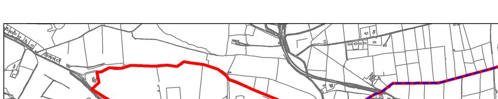


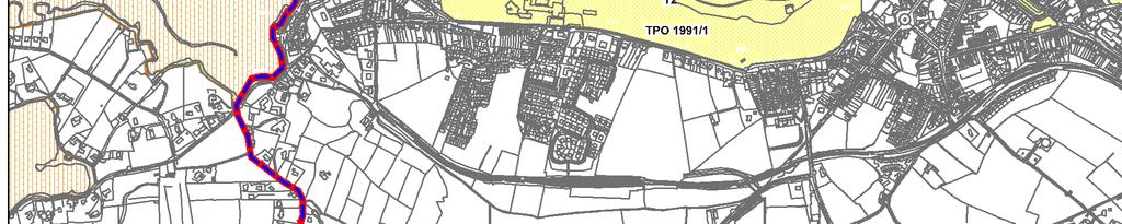


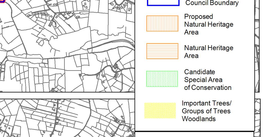


107
elbridge Core Strategy
 C elbridge Core Strategy Celbridge is designated as a Moderate Growth Town in the RPGs. The County Development Plan reinforces this designation in its settlement strategy. Moderate Growth Towns within
Chapter 3 Core Strategy
 Chapter 3 Core Strategy 3.0 Introduction The core strategy sets out how the development objectives in the Development Plan are consistent with the National Spatial Strategy and the Regional Planning Guidelines.
WINCHESTER TOWN 3.1 LOCATION, CHARACTERISTICS & SETTING
 WINCHESTER TOWN 3.1 LOCATION, CHARACTERISTICS & SETTING 3.1.1 The area referred to by the City Council, as Winchester Town, consists of the Winchester Wards plus the adjoining built up areas of Badger
Variation No 1: Dundalk & Environs Development Plan Core Strategy
 Variation No 1: Dundalk & Environs Development Plan 2009-2015 Core Strategy Adopted on 29 th August 2011 CONTENTS Page Section 1 1.0 Synopsis 1 1.1 Background Document 1 1.2 Variation of Dundalk and Environs
20. Ballysadare Mini-Plan
 20. Ballysadare Mini-Plan 20. Ballysadare Mini-Plan Community facilities Ballysadare has a wide range of community facilities: a primary school, St Mary s College (secondary school), a health centre, playing
Newcourt Masterplan. November Exeter Local Development Framework
 Newcourt Masterplan November 2010 Exeter Local Development Framework Background The Exeter Core Strategy Proposed Submission sets out the vision, objectives and strategy for the development of Exeter up
WELCOME GYPSY LANE. Wider Site Location plan. Proposals for the development of LAND OFF FOXLYDIATE LANE WEBHEATH. Proposals for the development of
 WELCOME The developers are preparing an outline planning application for a residential led development and need the community s views in order to develop the proposals further WHAT IS PROPOSED? A high
Proposed modifications to the proposed variation of the Westport Town & Environs Development Plan August 2011
 Proposed modifications to the proposed variation of the Westport Town & Environs Development Plan 2010-2016 August 2011 Westport Town Council Comhairle an Bhaile Cathair na Mart Mayo County Council Comhairle
2.0 Strategic Context 4
 2.0 Strategic Context 4 2.1 The Area Action Plan is a non-statutory plan, which forms a corporate policy document, expressing particular issues and areas of concern while also providing a vision for the
DUBLIN DOCKLANDS MASTER PLAN AND RELATIONSHIP WITH OTHER PLANS
 .1 National Policy and Programmes.1.1 Sustainable Development A Strategy for Ireland, 1997.1.2 National Climate Change Strategy, 2007-2012.1. National Development Plan 2007-201.1.4 National Spatial Strategy,
A Growing Community Rural Settlement Areas
 Town of Huntsville Official Plan Review - POLICY BACKGROUND PAPER A Growing Community Rural Settlement Areas BACKGROUND: In addition to the fully municipally-serviced Urban Settlement Area and the Hidden
Guidelines for Planning Authorities and Part V of the Planning and Development Act 2000: December 2000
 Slide 1 Slide 2 Slide 3 Slide 4 As a planner in practice, whether within the Local Authority, private practice or An Bord Pleanala, due regard must be given to the guidance provided by the Department in
Chapter 2: OUTLINE PLANNING APPLICATION PROPOSALS. A New Garden Neighbourhood Matford Barton 17
 Chapter 2: OUTLINE PLANNING APPLICATION PROPOSALS A New Garden Neighbourhood Matford Barton 17 2.1. SUMMARY AND STATUS OF THE PROPOSALS 2.1.1. The parameter plans and associated wording in this chapter
Strategic Environmental Assessment Screening Report. Dublin Port Masterplan Review 2017
 Strategic Environmental Assessment Screening Report Dublin Port Masterplan Review 2017 Table of Contents 1 Introduction... 1 2 Purpose of the Masterplan... 2 3 Task 1.1 Pre-Screening Check... 5 4 Task
Submission to the Kildare County Council Development Plan North Kildare Chamber. Executive Summary
 ` 28 th May 2015 Submission to the Kildare County Council Development Plan 2017-2023 North Kildare Chamber Executive Summary North Kildare Chamber s mission is to work with businesses, community groups,
17. Coolaney-Rockfield Mini-Plan
 County Development Plan 2017-2023 Consolidated Draft + Adopted Amendments - August 2017 17. Coolaney-Rockfield Mini-Plan Village profile Coolaney is located approximately 23 km to the south-west of Sligo
City Regions Ireland
 City Regions Ireland 01 CITY REGIONS IRELAND COMPRISES OF CORK CHAMBER, DUBLIN CHAMBER, LIMERICK CHAMBER, WATERFORD CHAMBER AND GALWAY CHAMBER, ALL MEMBERS OF CHAMBERS IRELAND. 5 CITIES 8 PRINCIPLES A
Kibworth Harcourt. Introduction. Introduction
 Introduction Introduction Welcome to this public exhibition on the proposals for the delivery of new homes on land at The Kibworths. The purpose of today s exhibition is to give you the opportunity to
6. Ballintogher Mini-Plan
 County Development Plan 2017-2023 Consolidated Draft + Adopted Amendments August 2017 Volume 2, Chapter 6 Ballintogher Mini-Plan 6. Ballintogher Mini-Plan Village profile Ballintogher is located approximately
STATEMENT OF OBJECTION TO THE PROPOSED DEVELOPMENT OF LAND AT CHURCH CLIFF DRIVE FILEY
 STATEMENT OF OBJECTION TO THE PROPOSED DEVELOPMENT OF LAND AT CHURCH CLIFF DRIVE FILEY You will be aware that Scarborough borough council have adopted a new local plan that includes land at Church Cliff
ROCHFORD LOCAL DEVELOPMENT FRAMEWORK: Sustainability Appraisal/ Strategic Environmental Assessment. Rochford Core Strategy Preferred Options Document
 ROCHFORD LOCAL DEVELOPMENT FRAMEWORK: Sustainability Appraisal/ Strategic Environmental Assessment Non Technical Summary Rochford Core Strategy Preferred Options Document October 2008 SUSTAINABILITY APPRAISAL
3.1 The hybrid planning application proposes the following description of development:
 CHAPTER 3: PROPOSED DEVELOPMENT 3.1 The hybrid planning application proposes the following description of development: Hybrid (part-outline/part-full) planning application for a single composite development
28. Coolaney-Rockfield Mini-Plan
 28. Coolaney-Rockfield Mini-Plan 28. Coolaney-Rockfield Mini-Plan Community facilities Community facilities in Coolaney-Rockfield consist of a primary school, crèche, community centre, sports field and
Appendix A: Retail Planning Assessment
 Rotherham Town Centre Masterplan Appendix A: Retail Planning Assessment 139 Appendix A Rotherham Town Centre Masterplan Retail Planning Background and Policy Context 1. Introduction 1.1 The Masterplan
Droitwich Spa 6. Reasoned Justification
 87 Droitwich Spa 6 Reasoned Justification 6.1 Droitwich Spa is identified in the settlement hierarchy (Policy SWDP1) as a main town being the largest settlement in Wychavon District with an estimated population
Plan Modification to Chapter B2 of the Auckland Unitary Plan(AUP) Operative in part (15 November 2016)
 Operative in part (15 November 2016)") UNITARY PLAN UPDATE REQUEST MEMORANDUM TO FROM Phill Reid Linley Wilkinson DATE 25 September 2018 SUBJECT Plan Modification to Chapter B2 of the Auckland Unitary Plan(AUP) Operative in part (15 November
UNITARY PLAN UPDATE REQUEST MEMORANDUM TO FROM Phill Reid Linley Wilkinson DATE 25 September 2018 SUBJECT Plan Modification to Chapter B2 of the Auckland Unitary Plan(AUP) Operative in part (15 November
Tāhuhu whakaruruhau ā-taone The sheltering ridge pole
 B2. Tāhuhu whakaruruhau ā-taone - Urban growth and form B2.1. Issues Tāhuhu whakaruruhau ā-taone The sheltering ridge pole Auckland s growing population increases demand for housing, employment, business,
Ipswich Issues and Options for the Ipswich Local Plan Review, August 2017, Public Consultation
 Ipswich Issues and Options for the Ipswich Local Plan Review, August 2017, Public Consultation Having reviewed the issues and options documents, the Society has made the following response: Part 1 Strategic
Killarney Town Development Plan ISSUES PAPER
 Killarney Town Development Plan 2015-2021 ISSUES PAPER 1 Introduction The Killarney Town Development Plan sets out the overall strategy for the proper planning and development of the town. The existing
Official Plan Review
 Official Plan Review Summary Report - The Built Environment August 2014 Part 1: Introduction Planning for a healthy, prosperous and sustainable community is an important goal for our municipality. From
CLOUGHJORDAN SETTLEMENT PLAN
 CLOUGHJORDAN SETTLEMENT PLAN 1.0 General Introduction and Development Context Location The market town of Cloughjordan lies close to the border with Offaly at the junction of the R490 and R491 Regional
Sustainability Statement. Whitby Business Park Area Action Plan
 Sustainability Statement Whitby Business Park Area Action Plan November 2014 Contents Page 1. Introduction 1 2. Scoping 3 3. Sustainability Appraisal of Options 6 4. Assessment of Draft Area Action Plan
Our City Centre is a vibrant, creative and welcoming destination, with a modern business, cultural, shopping, leisure and residential offer
 3. Sheffield in 2034 Our City sits at the heart of a strong, distinctive and internationally successful City Region economy which supports innovation and enterprise Our City Centre is a vibrant, creative
14.5 HOPEFIELD: (REFER PLAN 39 AND PLAN 40)
") URBAN DYNAMICS WESTERN CAPE INC. 248 14.5 HOPEFIELD: (REFER PLAN 39 AND PLAN 40) FIGURE 83: LOCALITY - HOPEFIELD Within the context of the Saldanha Bay Municipal area, Hopefield, an historical agricultural
URBAN DYNAMICS WESTERN CAPE INC. 248 14.5 HOPEFIELD: (REFER PLAN 39 AND PLAN 40) FIGURE 83: LOCALITY - HOPEFIELD Within the context of the Saldanha Bay Municipal area, Hopefield, an historical agricultural
County Development Plan Consolidated Draft + Adopted Amendments August 2017 Volume 2, Chapter 22 Easky Mini-Plan
 22. Easky Mini-Plan Village profile Easky is a coastal settlement located approximately 40 km to the west of Sligo City, in a designated Rural Area In Need of Regeneration. The nearby coastline is designated
9 Pershore. Introduction. Pershore Abbey
 118 Introduction 9.1 The historic town of Pershore lies on the River Avon and has a population of 7,000 (2009 Mid-Term Population Estimates). The main areas of the town are centred on the Abbey, the bustling
Page 1 of 19 URBAN DESIGN FRAMEWORK FOR BOLTON STREET WATERFORD
 Page 1 of 19 URBAN DESIGN FRAMEWORK FOR BOLTON STREET WATERFORD 1.0 Introduction: The relocation of the City Council stores and depot from Bolton Street creates an exciting opportunity for development
Great Easton Neighbourhood Plan Statement of Basic Conditions
 Great Easton Neighbourhood Plan 2017-2031 Statement of Basic Conditions OCTOBER 2016 GREAT EASTON PARISH COUNCIL Contents 1.0 Introduction....Page 2 2.0 Summary of Submission Documents and Supporting Evidence..
WELCOME. Land North of STEVENAGE. We would like to thank you for attending our public exhibition today.
 WELCOME We would like to thank you for attending our public exhibition today. The purpose of this event is to share our proposals and hear your thoughts on our ideas. Members of the project team are on
INCREMENTAL CHANGE AREA REVIEW March 2015 Page 1
 INCREMENTAL CHANGE AREA REVIEW March 2015 Page 1 Table of Contents Introduction... 3 Background to Review... 3 Comparison of the Schedules to the General Residential Zone... 7 Methodology... 7 Policy Context...
Colchester Northern Gateway Master Plan Vision Review Draft. July 2016
 Colchester Northern Gateway Master Plan Vision Review Draft July 2016 Contents Introduction 4 Context 8 Purpose of the Report 8 Strategic Position 9 Overview of the Process 11 2012 Master Plan Vision 12
CITY OF COLWICH COMPREHENSIVE PLAN LAND USE LAND USE 1
 LAND USE LAND USE 1 WHAT YOU WILL FIND IN THIS CHAPTER: Discussion of today s conditions and tomorrow s projections Discussion of challenges and opportunities Discussion of the environmental quality goals,
I615. Westgate Precinct
 I615. Westgate Precinct I615.1. Precinct Description The Westgate Precinct is located approximately 18km west of the Auckland city centre. There are seven Sub-precincts in the Westgate Precinct: Sub-precinct
SECTION ONE: INTRODUCTION. introduction
 introduction 1 INTRODUCTION Since it was first established in 1843 as a trading post for the Hudson s Bay Company, Victoria has evolved into a Provincial capital city that is recognized across Canada and
Valuing Historic Places
 Valuing Historic Places Introduction Historic buildings and places have played an increasingly central role in the delivery of a range of public benefits, including education, economic development, sustainable
Stratford Neighbourhood Plan Questionnaire
 Stratford Neighbourhood Plan Questionnaire Please tick the appropriate box or answer in the space provided. If you require further copies of the questionnaire, as more than one person in the household
CORK County Development Plan 2003
 3 VOLUME 3 Specific Zoning Main Settlements Zoning Main Settlements Contents of Volume 3 Settlement 1: BALLINCOLLIG TEXT MAP Settlement 2: BANDON TEXT MAP Settlement 3: BANTRY TEXT MAP Volume 1: Overall
30. Riverstown Mini-Plan
 County Development Plan 2017-2023 Consolidated Draft + Adopted Amendments August 2017 Volume 2, Chapter 30 Riverstown Mini-Plan 30. Riverstown Mini-Plan Village profile Riverstown is located approximately
35. Gorteen Mini-Plan
 35. Gorteen Mini-Plan 35. Gorteen Mini-Plan Community facilities Community facilities in Gorteen consist of a crèche, community centre, sports field, church, burial ground and health centre. The former
Variation No.1 Galway County Development Plan Adopted: 24th April 2017
 Variation No.1 Galway County Development Plan 215-221 Adopted: 24th April 217 Chapter 2 - Spatial Strategy, Core & Settlement Strategy 2.1 Background In its simplest terms the County Development Plan s
Meath County Development Plan. Variation No. 1 to Volume 1 Written Statement
 Meath County Development Plan 2013 2019 Variation No. 1 to Volume 1 Written Statement 2 Core Strategy Adopted Variation No. 1-04/11/2013 2.3.3 Residential Zoned Land Provision Table 2.4 details the requirement
SPG 1. * the northern and western sections which are open fields used for pasture and grazing;
 SPG 1 1.0 INTRODUCTION This development brief is based on the allocation of the Priors Hall site for employment and countryside recreational purposes in the Corby Borough Local Plan. The brief is intended
OKEFORD FITZPAINE NEIGHBOURHOOD PLAN
 OKEFORD FITZPAINE NEIGHBOURHOOD PLAN Dear Parishioner, The Neighbourhood Plan Project Team have prepared this leaflet to summarise the full Neighbourhood Plan document. It provides a summary of the Vision,
Plean Forbairt Development Plan
 1 COMHAIRLE THOGHLACH DHROICEAD ATHA DROGHEDA BOROUGH COUNCIL Plean Forbairt 2005 2011 Development Plan 2005-2011 2 Project Team: Planning Terence Savage: Senior Executive Planner (Acting) - Drogheda Borough
INTRODUCTION NORTH HEYBRIDGE GARDEN SUBURB
 INTRODUCTION This event is being hosted by the promoters of the proposed North Heybridge Garden Suburb who are working with Maldon District Council and other key stakeholders on the preparation of a comprehensive
Planning Proposal Toronto Road, Booragul. Amendment to Lake Macquarie Local Environmental Plan (LMLEP) 2014
 2014") Planning Proposal Toronto Road, Booragul Amendment to Lake Macquarie Local Environmental Plan (LMLEP) 2014 Local Government Area: Name of Draft LEP: Subject Land: Land Owner: Applicant: Folder Number:
Planning Proposal Toronto Road, Booragul Amendment to Lake Macquarie Local Environmental Plan (LMLEP) 2014 Local Government Area: Name of Draft LEP: Subject Land: Land Owner: Applicant: Folder Number:
Edward R. Sajecki Commissioner of Planning and Building
 Corporate Report Clerk s Files Originator s Files CD.03.POR DATE: TO: FROM: SUBJECT: Chair and Members of Planning and Development Committee Meeting Date: February 27, 2012 Edward R. Sajecki Commissioner
Dunboyne/Dunboyne North/ Clonee/ Local Area Plan
 Dunboyne/Dunboyne North/ Clonee/ Local Area Plan Strategic Policy SP 1 To operate an Order of Priority for the release of residential lands in compliance with the requirements of CS OBJ 6 of the County
Welcome to our exhibition
 Welcome to our exhibition The Homes & Communities Agency (HCA) welcomes you to this public exhibition explaining our proposals for the redevelopment of the former Lea Castle Hospital site. About the Homes
4 RESIDENTIAL ZONE. 4.1 Background
 4 RESIDENTIAL ZONE 4.1 Background The residential areas within the City are characterised by mainly lowrise dwellings sited on individual allotments. Past architectural styles, settlement patterns and
9 CITY OF VAUGHAN OFFICIAL PLAN AMENDMENT NO BOCA EAST INVESTMENTS LIMITED
 9 CITY OF VAUGHAN OFFICIAL PLAN AMENDMENT NO. 631 - BOCA EAST INVESTMENTS LIMITED The Planning and Economic Development Committee recommends the adoption of the recommendations contained in the following
RURAL ZONE - POLICY. Rural Zone Policy. Issue: Rural Environment. Ruapehu District Plan Page 1 of 8
 Rural Zone Policy RU2 RURAL ZONE - POLICY RU2.1 Introduction The natural resources of the rural environment in the Ruapehu District provide the basis for the existing and potential character, intensity
Brighton Marina Neighbourhood Forum AGM. City Plan Part Two - Draft Plan
 Brighton Marina Neighbourhood Forum AGM City Plan Part Two - Draft Plan 16 May 2018 Sandra Rogers Planning Manager Carly Dockerill & Robert Davidson Principal Planning Officers Presentation outline: Context
3. Neighbourhood Plans and Strategic Environmental Assessment
 1. Introduction This report sets out a draft Screening Determination for the Preston Parish Council s Neighbourhood Plan and has been prepared by rth Hertfordshire District Council. The purpose of the
PLANNING ADVISORY BOARD AGENDA OCTOBER
 ! City of Langley PLANNING ADVISORY BOARD AGENDA OCTOBER 1, 2014 3-5pm LANGLEY CITY HALL - 112 2 nd Street, Langley WA 1) Call to Order and Roll Call 2) Approval of the Minutes September 10, 2014 3) Public
About 10% of the Borough's population lives in the seven rural parishes. Population figures from the 1991 census are given below:-
 8. THE DISTRICT VILLAGES 8.1 Population About 10% of the Borough's population lives in the seven rural parishes. Population figures from the 1991 census are given below:- Village No. of Persons Cottingham
Rathmolyon Written Statement
 Settlement Rathmolyon Position in Settlement Hierarchy Village - Local centre for services and local enterprise development Position in Retail Strategy Fourth tier retail centre Population (2011) Census
Welford-on-Avon Neighbourhood Plan Consultation Event Sunday, 6 April Your name Your address
 Welford-on-Avon Neighbourhood Plan Consultation Event Sunday, 6 April 2014 Your name Your email address Please either: - complete this feedback form and put it in the box before leaving the Memorial Hall
heuston gateway: sections heuston gateway: regeneration strategy and development framework plan
 B B1 A B1 B C A heuston gateway: sections B B1 C 117 4.3.3 Zoning The station is the central hub of the area and this function must be preserved and developed. However large areas of the Heuston Station
Schedule of Planning Applications Committee Date: 23 May Reference: 06/17/0726/F Parish: Hemsby Officer: Mr J Beck Expiry Date:
 Schedule of Planning Applications Committee Date: 23 May 2018 Reference: 06/17/0726/F Parish: Hemsby Officer: Mr J Beck Expiry Date: 22-05-2018 Applicant: Proposal: Site: Mr Gillett Change of use to the
MATURE SUBURBS RESIDENTIAL DEVELOPMENT GUIDELINES
 MATURE SUBURBS RESIDENTIAL DEVELOPMENT GUIDELINES DRAFT FEBRUARY 2005 BIRMINGHAM CITY COUNCIL 1 Introduction Mature Suburbs Residential Development Guidelines - Interim Supplementary Planning Advice -
BORRISOKANE SETTLEMENT PLAN
 BORRISOKANE SETTLEMENT PLAN 1.0 General Introduction and Development Context Location Borrisokane is located 15km north of Nenagh on the N52. While the town is primarily residential, it acts as a market
3.0 Policy Context. 3.1 Introduction. 3.2 National Spatial Strategy, The Role of East Meath under the NSS
 3.0 Policy Context 52 Policy Context 3.0 Policy Context 3.1 Introduction There is an extensive range of strategic guidance and policy for land use planning in Ireland. This has been fully examined in the
DUNSFOLD NEIGHBOURHOOD PLAN Site Selection Policies
 DUNSFOLD NEIGHBOURHOOD PLAN Site Selection Policies The criteria for assessing sites for future housing and business development in Dunsfold are set out below. (Development criteria, covering what it is
LONGDEN VILLAGE DEVELOPMENT STATEMENT
 LONGDEN VILLAGE DEVELOPMENT STATEMENT 2017-2027 1 Longden Development Statement 2017-2027 15/01/18 1. Background 1.1 Longden Village Longden village is a very rural and traditional community first mentioned
1.0 PLANNING MARKHAM S FUTURE CONTENTS
 1-1 Planning Markham s Future 1.0 PLANNING MARKHAM S FUTURE CONTENTS 1.1 THE PURPOSE OF THE OFFICIAL PLAN 1.2 THE MARKHAM CONTEXT 1.3 THE REGULATORY CONTEXT 1.3.1 Province of Ontario 1.3.2 York Region
A VISION FOR BLAIRGOWRIE
 Welcome to the Westpark Partnership and Lidl UK GmbH Community Presentation. The purpose of this presentation is for you to view and comment upon the revised and updated proposals for the allocated development
Tiane Ltd Submission on Draft National Planning Framework Ireland 2040
 Tiane Ltd Submission on Draft National Planning Framework Ireland 2040 Date: 31 st March 2017 Authors: Ken Swaby / Ben Waite Approved By: Christy O'Sullivan ILTP Project Code & Reference: GOLDENATH Distribution:
BLETCHLEY PARK AREA - DEVELOPMENT FRAMEWORK
 ANNEX A To Item 9 REVISED TEXT: additions shown bold and underlined, deletions in (brackets and in italics). BLETCHLEY PARK AREA - DEVELOPMENT FRAMEWORK This framework sets out the key objectives and requirements
Commercial, Retail and Tourism Executive Summary December 2018
 Town of Wasaga Beach Official Plan Review, Retail and Executive Summary December 2018 1 An Official Plan directs where and how to grow The preparation of a new Official Plan for Wasaga Beach is an opportunity
Edenderry Local Area Plan
 Edenderry Local Area Plan 2017-2023 MATERIAL ALTERATIONS TO DRAFT EDENDERRY LOCAL AREA PLAN Public Display Document Section 1: Introduction 1.1 Introduction This report focuses on the proposed material
Maynooth. Local Area Plan Plean Cheantar Aitiuil Mháigh Nuad. 26th August 2013
 Maynooth Local Area Plan 2013 2019 Plean Cheantar Aitiuil Mháigh Nuad 26th August 2013 Table of Contents PART A Introduction and Context 1.0 Introduction 5 1.1 Local Area Plans Status and Process 6 1.2
2. Spatial Portrait, Vision and Objectives
 VISION & OBJECTIVES 2. Spatial Portrait, Vision and Objectives Introduction 2.1 This section sets out the spatial portrait of Uttlesford, the vision we have for the future of the area and the objectives
Suffolk Coastal Local Plan Review Issues and Options, August 2017, Public Consultation
 Suffolk Coastal Local Plan Review Issues and Options, August 2017, Public Consultation Having reviewed the issues and options documents, the Society has made the following response: Part 1 - Strategic
PSRC REVIEW REPORT & CERTIFICATION RECOMMENDATION
 PSRC REVIEW REPORT & CERTIFICATION RECOMMENDATION KITSAP COUNTY COUNTYWIDE PLANNING POLICIES July 2, 2012 BACKGROUND A major emphasis of the Washington State Growth Management Act (GMA) is the need to
EVALUATION OF MASTER PLAN ALTERNATIVES
 7 The Environmental Report is required to identify, describe and evaluate reasonable alternatives, taking into account the objectives and geographical scope of the Master Plan 2008. Three plan alternatives
Ballinasloe Town Development Plan as Varied on
 Ballinasloe Town Development Plan 2009-2015 as Varied on 12-07-2011 SECTION 1. INTRODUCTION AND CONTEXT... 5 1.1 INTRODUCTION... 5 1.2 LEGISLATIVE CONTEXT... 5 1.3 POLICY CONTEXT... 7 1.4 THE PLAN AS A
6 Growth Management Challenges and Opportunities
 6 Growth Management Challenges and Opportunities The Town has established a goal of attaining a 50% participation rate with respect to employment opportunities versus residential population. The Town s
Chapter 2 Core Strategy
 Chapter 2 Core Strategy 11-24 2.1 Introduction 2.2 Strategic Planning Approach 2.3 Growth Consistency with the National Spatial Strategy & Regional Planning Guidelines 2.1 Introduction The overall strategy
Meath County Development Plan. Proposed Draft Variation No. 1 to Volume 1 Written Statement
 Meath County Development Plan 2013 2019 Proposed Draft Variation No. 1 to Volume 1 Written Statement 2 Core Strategy Proposed Draft Variation No. 1!" #$ % & ' % $ ($ &' ) $) * (' &+( &' % $ * $ $ * %
ALLERTHORPE NEIGHBOURHOOD PLAN
 Allerthorpe s Neighbourhood Plan sets out a vision for the Parish for the next 15 years (2018 2033) that builds on and reflects the opinions and views of parish residents. VISION In 2033 Allerthorpe will
Draft Island Development Plan
 Draft Island Development Plan February 2015 Written Statement Contents Part One 1 About the Island Development Plan What is the Island Development Plan? What is the Island Development Plan used for? Structure
Overview Report. Proposed Development
 Overview Report Proposed Development the construction of a 1km cycle/pedestrian trail including a new footbridge, new car park and entrance road at Drumshanbo Lock and a new pedestrian/cycle road crossing,
Sustainable Growth. Sustainable Growth
 2 Sustainable Growth Sustainable Growth SUSTAINABLE GROWTH 2.1 COMMUNITY VISION... 2-5 2.2 THE CITY SYSTEM... 2-7 2.2.1 AREAS... 2-7 2.2.2 CITY-WIDE SYSTEMS... 2-8 2.2.3 PROVINCIAL PLAN BOUNDARIES AND
Planning and Sustainability Statement
 Land adjacent to Manor Farm, Catterick Village Pallett Hill Sand and Gravel Co Ltd Proposed 10 new dwellings, (6 No market dwellings and 4 No affordable dwellings) with access, associated car parking and
Western City District What we heard
 What we heard Vision to 2056 and Priorities Governance and implementation Infrastructure and funding The protection of the natural landscape including biodiversity and the Metropolitan Rural Area for food
Stantonbury Neighbourhood Plan
 Stantonbury Neighbourhood Plan 2018-2031 Basic Conditions Statement October 2018 Intentionally blank 1.0 Basic Conditions Statement Introduction 1.1 This statement has been prepared by Stantonbury Parish
2040 LUP is a part of the Comprehensive Plan and carries the same legal authority. Economic Challenges
 1.1. Guiding Anchorage s Growth Where will new residents settle over the next two decades? Where will people work, shop, and play? Will there be enough room to grow? How will Anchorage look? Will growth
DEVELOPMENT MANAGEMENT REPORT
 ITEM A08-1 DEVELOPMENT MANAGEMENT REPORT TO: BY: DATE: DEVELOPMENT: SITE: WARD: APPLICATION: APPLICANT: Development Management Committee Development Manager Proposed live/work unit in connection with existing
Ratthcaiirrn Wrriitttten Sttattementt
 Ratthcaiirrn Wrriitttten Sttattementt Settlement Rathcairn Position in Settlement Hierarchy Village Serve a smaller rural catchment; provide local services with some smaller scale rural enterprises in