Rosslyn-Ballston Corridor Streetscape Standards
|
|
|
- Madeleine Hawkins
- 5 years ago
- Views:
Transcription


1 Rosslyn-Ballston Corridor Streetscape Standards FINAL MAY, 2003 updated June, 2007 Prepared by the Department of Community Planning, Housing and Development, Planning Division
2
3 TABLE OF CONTENTS I. Purpose...1 II. Streetscape Zones, Materials, and Dimensions...2 A. Shy Zone...2 B. Clear Zone...2 C. Landscape and Furniture Zone...4 III. Street Tree Planting...7 A. Street Tree Spacing...11 B. Street Tree Size...11 C. Street Tree Types...11 IV. Street Furniture...12 V. Transition Areas...14 VI. Special Considerations...16 VII. Implementation...16 VIII. Streetscape Standards by Metro Station Area...16 A. Rosslyn...20 B. Court House...22 C. Clarendon...24 D. Virginia Square...27 E. Ballston Ballston C-O-A Streetscape Standards C-O-A Sidewalk Widths Placement of Streetscape Elements in the Sidewalk...33 i
4 LIST OF FIGURES 1. R-B Corridor Streetscape Example of Acceptable Clear Zone Treatment (slate texture) Example of Acceptable Clear Zone Treatment (broom finish) Concrete Pedestrian Pavers Installation Sand Set over Aggregate Base Concrete Pedestrian Pavers Installation Sand Set over Asphalt Concrete Pedestrian Pavers Installation Sand Set over Concrete Standard Tree Grates Typical Street Tree Planting Detail Plan View Standard Tree Grate and Concrete Paver Sidewalk High Density Residential Planting Options Street Tree Spacing Street Furniture Incorrect Installation of Utility or Street Furniture Correct Installation of Utility or Street Furniture Installation of Manhole Cover Corner Transition from One Streetscape Standard to Another Transition from a Wider Sidewalk to a Narrower Sidewalk with Different Street Tree Treatments Example Streetscape Type A Example Streetscape Type B Example Streetscape Type C Rosslyn Streetscape Map Court House Streetscape Map Clarendon Streetscape Map Virginia Square Streetscape Map Ballston Streetscape Map Ballston C-O-A Streetscape Standards (Sections) Ballston C-O-A Streetscape Standards (Plan Views) ii

5 FIGURE 1. R-B Corridor Streetscape I. Purpose The Rosslyn-Ballston (R-B) Corridor Streetscape Standards consolidate guidelines from several Arlington County policy documents. These documents include: the Sector Plans for each of the five Metro Station Areas in the Corridor, the Master Transportation Plan, Standard Site Plan Conditions, Administrative Regulation 4.3 (Tree Planting), and "Standards for the Preservation and Planting of Trees on Site Plan Projects" ("Tree Standards"). These standards identify a consistent treatment for all public sidewalk areas in the R-B Corridor. The following standards are designed to coordinate the visual and physical aspects of development on different sites. This includes coordinating new developments of different densities and types with each other, as well as coordinating new development with existing features. The goal is to create public and private spaces that provide comfort, utility and amenity for all who use them. The streetscape standards are organized as follows: Streetscape Zones; Street Tree Planting; Street Furniture; Transition Areas; Special Considerations; Implementation; and Streetscape Standards by Metro Station Area. A hierarchy of streetscape treatments has been developed relating to the type and intensity of development in an area. The maps in this document are organized around Metro station and sector plan areas. In most cases, the three types of streetscape are A, B, and C. Streetscape A is the widest sidewalk, occurring in the densest urban areas. Streetscape B is in less urban but still highly traveled areas and Streetscape C occurs in more residential areas of the corridor. As an exception, the recently updated 2006 Clarendon Sector Plan includes five streetscape types, instead of the three streetscape types indicated in most other station areas. Also, the Ballston area has additional requirements as called out in the Ballston Area Sector Plan and referenced in this document. 1
6 II. Streetscape Zones, Materials and Dimensions Streetscapes include the area from building face to building face on both sides of the street and all the elements in between. This document will focus on what are traditionally considered elements of the Pedestrian Realm, within the larger streetscape environment. The Pedestrian Realm Streetscape typically consists of the following zones: 1. Shy Zone 2. Clear Zone 3. Landscape & Furniture Zone An array of paving materials may be used in the design and construction of streetscapes, which vary according to the specific streetscape zones. Recommended standards for paving materials, dimensions, and applicability for each streetscape zone are detailed below. II.A Shy Zone The shy zone is a walkable surface adjacent to a building face, typically wide. This area is meant to accommodate any building protrusions, such as blade signs, standpipes, bay windows, and any outdoor commercial displays. It functions as an area on busy sidewalks that allow pedestrians to linger and window shop out of the way of most pedestrians. Shy zones are not needed adjacent to sidewalk cafés or where buildings are set back from the back edge of sidewalk. Materials: Pre-cast pavers, brick, and poured-in-place concrete (colors vary). Dimensions of Zone: 18-24, depending on pedestrian density and adjacent uses. Applicability: For use in streetwall building locations. Does not apply when adjacent to building-side cafés. II.B Clear Zone The clear zone's primary purpose is to facilitate safe, direct, accessible pedestrian mobility. It is usually located between the landscape & furniture zone and the building or shy zone. This space is largely unobstructed and constructed of materials and patterns that provide a relatively smooth surface that complies with or exceeds ADA accessibility standards. In Arlington County, the standard clear zone material is poured-in-place concrete with a range of surface treatment options, discussed in more detail below. Specific clear zones may be established by sector and local area plans for high-density, mixed-use and commercial areas, which range from six feet to twenty-four feet. In these areas, cafés may encroach up to four feet into the clear zone provided that a minimum of six feet clear is maintained. In lower-density and residential areas, the minimum clear zone width is four feet. With regard to vertical clearance, a minimum of eight feet must be maintained. Occasional, unavoidable pinch points are acceptable, provided they do not narrow the clear zone by more than two feet, and are not longer than two linear feet of frontage. In no case shall a pinch point be permitted when it would reduce a sidewalk s clear width to less than 48 inches or otherwise make a walkway inaccessible as per ADA standards. 2

7 Materials: Poured-in-place concrete. Gaps 1 4-in. deep or greater may not be spaced any closer than 30" avg. Dimensions of Zone: 6 minimum (high-density) / 4 minimum (low-density) typical. Exact dimension depends upon pedestrian density and adjacent uses. Applicability: All sidewalks. Alternatives and Options (subject to approval): Typically, decorative clear-zone concrete is not tinted. However, projects are encouraged to incorporate integral colors that harmonize with their surroundings. Non-standard materials and surface treatments such as concrete pavers or clay bricks may be permitted in special locations, provided these materials are free of bevels or chamfers. Such areas may include: 1. prominent vistas 2. corners 3. significant building entries 4. transition areas. (See below for allowable, non-compliant materials). Base preparation and construction must conform with acceptable details. Non-compliant sidewalk clear zone materials (ie: bevelled pavers) may be used in specific, limited installations (such as repairs of existing sidewalks) where the predominant sidewalk material is also non-compliant. Such situations shall meet either of the following contextual indicators: 1. Proposed sidewalk occupies less than 50% of the block face, OR 2. Pre-existing streetscape had been adopted as part of a PDSP. FIGURE 2. Example of Acceptable Clear Zone Treatment (slate texture) Detail of slate texture. Note the directional pattern. 3

8 FIGURE 3. Example of Acceptable Clear Zone Treatment (broom finish) Detail of broom finish texture. Note the 2 troweled edge inside the tooled joint. II.C Landscape and Furniture Zone The landscape and furniture zone is typically located between the curb and the clear zone. This area is where most street side landscaping is located, most importantly, street trees. It also accommodates parking meters, utility poles, bicycle racks, bollards, streetlights, garbage cans, bus shelters, signage, and benches. For more detail on the Landscape and Furniture zone, see Section III. Street Tree Planting and Section IV. Street Furniture. Materials: With Tree Grates or Pits: Pre-cast pavers, brick, poured concrete (colors vary). With Planting Strip: No Paving Materials Applicable. Dimensions of Zone: 4-6, varies according to street type and adjacent densities: o 6 preferred adjacent to high-density developments and high pedestrian volume streets. o 5 minimum acceptable for standard streets. o 4 minimum acceptable for accommodating street trees. Applicability: All sidewalks, wherever possible. Landscape zones in commercial areas should not be less than 4 wide. Where pavers are used, their edges should be fixed in order to keep them from moving horizontally. Where pavers meet a lawn or planted area, Ryerson Steel Edging (or equal) should be used to hold the edge of the sidewalk in place. Wood strips are not acceptable as an edging. 4
9 FIGURE 4. Concrete Pedestrian Pavers Installation Sand Set over Aggregate Base FIGURE 5. Concrete Pedestrian Pavers Installation Sand Set over Asphalt 5

10 FIGURE 6. Concrete Pedestrian Pavers Installation Sand Set over Concrete 6
11 III. Street Tree Planting Trees are an important urban amenity. Street trees provide shade and some protection from the weather. They create a sense of pedestrian scale by drawing the eye away from height of buildings. Trees evenly spaced along a street give the appearance of a landscaped boulevard and help tie the streetscape together as a whole. These tree planting standards reflect a policy adopted during the development of the Sector Plans in the Rosslyn-Ballston Corridor of designating one type of street tree per street, but different trees for different streets. The intent is to create continuity along each street but also to allow variety throughout an entire area. This philosophy of continuity is the main rationale behind the R-B Corridor Streetscape standards. FIGURE 7. Standard Tree Grates In the Rosslyn-Ballston Corridor, street trees are to be planted in tree pits adjacent to the back of the street curb and within the 5-foot wide public planting and utility strip (with the exception of the area covered by the Ballston Streetscape Standards. See pages 30-32). The following tree planting methods shall be used: 7
12 Tree grates may be appropriate in high-traffic areas, typically in high-density residential and commercial areas where parking is provided at the street. A minimum 5-foot by 8-foot Neenah (or equal) tree grate shall be used. Larger grate and pit sizes, e.g., 5' x 12', are optional as may be necessary for larger trees. (See Figure 7 for details). The tree grate shall be placed approximately 8 inches or one soldier course from the back of curb with the longest dimension parallel to the curb. FIGURE 8. Typical Street Tree Planting Detail 8
13 STANDARD CURB & GUTTER BRICK PAVERS STEEL EXPANDABLE TREE GRATE FIGURE 9. Plan View-Standard Tree Grate and Concrete Paver Sidewalk Where high-density residential planting options are designated on the map set, one of the options shown in Figure 10 may be used (sod, liriope, hypericum or other approved ground cover placed around the tree). These are primarily intended for use in medium to high density residential areas. In special circumstances, to be determined as part of the site plan review process, other planting techniques such as raised planters or planting beds may be used in the streetscape for plants but not for tree planting. Planters should not conflict with pedestrian movement or curb-side pedestrian drop off from automobiles. 9


14 FIGURE 10. High Density Residential Planting Options FIGURE 11. Street Tree Spacing 10
15 III.A Street Tree Spacing Trees are to be placed 30 feet on center, centered in the tree pit and a minimum of 2'- 6" back from the back of the curb (2'-0" when planted in a tree strip). The final location of street trees will be shown on the final site engineering plan, to be reviewed by the Department of Environmental Services; and on the landscape plan, to be reviewed by the Planning Division of the Department of Community Planning, Housing and Development and the Department of Parks, Recreation, and Cultural Resources. The spacing of streetlights and street trees should be coordinated to allow regular spacing as far as possible. In general, street trees should be no closer than 12 to 15 feet to a street light. In areas designated Low Residential on the General Land Use Plan where overhead utility wires are present and will not be removed by redevelopment, tree location and type will be considered on a case by case basis. III.B Street Tree Size The following standards apply regarding size of street trees to be planted. Major deciduous trees 4 to 6 minimum caliper, 16 to 30 feet in height. Ornamental trees 3 to 4 minimum caliper, 10 to 12 feet minimum height. III.C Street Tree Types During the Sector Plan Review Process, certain key streets were chosen to be planted with Willow Oaks throughout the length of the corridor to create the effect of a continuous boulevard. These streets include the Wilson Boulevard and Clarendon Boulevard one-way pair; Washington Boulevard; Fairfax Drive; and 10 th Street North. Street trees for other streets were chosen by the Sector Plan Review Committees on a station area by station area basis. These are listed in the R-B Corridor Streetscape Map set. In most cases, species shall be consistent on each street. All street trees must adhere to the Standards for American Standard for Nursery Stock and must meet the standards of Administrative Regulation 4.3; the standards contained in site plan conditions (for site plan approval projects) or the Arlington County Zoning Ordinance (for by-right development); and the Tree Standards. 11

16 IV. Street Furniture Street furniture includes light poles, parking meters, trash receptacles, benches, bollards, bicycle racks and signs anything that is placed within the streetscape. It is the intent of the Sector Plans that street furniture in the streetscape is consistent in appearance throughout the R-B Metro Corridor. Street furniture should also be placed where pedestrian traffic will not be obstructed. Most street furniture should be of a dark neutral color such as brown, dark green or black. Exceptions may include sign posts and parking meter posts. Where benches or trash receptacles are allowed (see individual Sector Plans), they should be placed so that the sidewalk is clear and unobstructed. A variety of street furniture should be allowed as detailed in each individual Sector Plan. All of the publicly installed elements, such as lights and parking meters, shall be placed within the planting and utility strip (with the exception of the area covered by the Ballston Streetscape Standards, where the placement of lighting and other street furniture is different in some cases). (See Figure 12.) Installation FIGURE 12. Street Furniture Installation of all street furniture or utilities shall be done so that the finished walk is not marred by unsightly patches of concrete or asphalt. 12
17 WRONG CONCRETE PATCH USED TO HOLD POLE IN PLACE FIGURE 13. Incorrect Installation of Utility or Street Furniture Where pavers must be removed to place a parking meter, bench or trash receptacle support, they shall either be cut and fitted around the installed item, or a metal skirt or bell should be fitted over the base of the pole or support so that it covers the hole in the pavement. (See Figures 13 and 14.) RIGHT METAL BELL PLACED AROUND BASE OF POLE FIGURE 14. Correct Installation of Utility or Street Furniture Where any utility (such as a manhole cover, water meter access plate or cover) must be part of the sidewalk, it should be flush with the sidewalk surface. Where a utility is surrounded by pavers (typically outside of the clear zone) it should not have a concrete footing around it at the level of the sidewalk surface, but rather the footing should be recessed so that the pavers may rest on it and be cut to fit around the utility. (See Figure 15.) Within the redevelopment areas of the Rosslyn- Ballston Metro Corridor, all utilities are to be placed underground in accordance with the undergrounding plan. 13

18 FIGURE 15. Installation of Manhole Cover V. Transition Areas Transition areas are instances where the streetscape standards vary from one street to the next. Where the two streets meet at a corner, a transition must be achieved between the two standards. Figures 16 and 17 show how this should be achieved. In general, the following guidelines should apply: When an existing paver sidewalk transitions into a concrete sidewalk, the pavers should continue around the corner at least to the end of the radius of the curb return. Where pavers are appropriate, they should also continue to some natural point of division such as a drive entrance, the edge of a planter, a walkway, etc. Right angles of wall planters should be eliminated at corners to allow better pedestrian movement around the corner. 14


19 FIGURE 16. Corner Transition from One Streetscape Standard to Another FIGURE 17. Transition from a Wider Sidewalk to a Narrower Sidewalk with Different Street Tree Treatments 15
20 VI. Special Considerations Each Sector Plan contains general urban design standards for development in addition to specific standards applying only to a particular sector plan area. These general standards relate to plaza design, building facades, signage, screening, parking and other elements and are intended to coordinate various kinds of uses, pedestrian and vehicular traffic, and provide for a pleasant and functional pedestrian environment. This document is intended to provide a composite of considerations relating to streetscape elements. The sector plan for each area should be consulted in addition to these standards VII. Implementation Implementation of the Rosslyn-Ballston Streetscape Standards shall be accomplished through the site plan approval process as site plan conditions. These standards shall be reflected on all site plan submittals in the R-B Corridor. These improvements shall be shown on the final site engineering plan, to be reviewed by the Department of Environmental Services; and on the landscape plan, to be reviewed by the Planning Division of the Department of Community Planning, Housing and Development and the Department of Parks, Recreation, and Cultural Resources. Installation of all improvements shall meet Department of Environmental Services standards and specifications. An example and description of each type of streetscape A, B, and C are shown in Figures VIII. Streetscape Standards By Metro Station Area Streetscape standards are listed for each Metro Station Area on the following pages. Street trees within each Metro Station are listed by street. Example streetscape types depicted on following pages are typical streetscape types. However, Clarendon and Ballston have additional parameters for desired streetscape conditions in those areas. 16
 tree pits with grates or approved groundcover. FIGURE 19.")
21 FIGURE 18. Example Streetscape A Streetscape A is located in areas with highest level of development, and thus the most pedestrian activity. It requires a minimum 16'-8" wide sidewalk with 5 x8 (or larger) tree pits with grates or approved groundcover. FIGURE 19. Example Streetscape B Streetscape B includes less dense areas and requires a 13'-0" wide sidewalk with 5 x8 (or larger) tree pits with grates or approved groundcover. 17
22 FIGURE 20. Example Streetscape C Streetscape C includes those streets with even less dense development. The requirements for these areas are a 6-foot wide concrete sidewalk plus a minimum 4-foot wide planting strip. The street trees shall be planted in the planting strip. 18

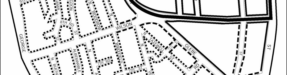
23 FIGURE 21. Rosslyn Streetscape Map 19
24 VIII.A Rosslyn TYPE SIDEWALK STREET TREE TREATMENT OTHER A Minimum width: 16'-8" Trees in 5 x8 (or larger) tree pits with grates or approved groundcover (liriope) B Minimum width: 13'-0" Trees in minimum 4 planting strip or 5 x8 (or larger) pits with grate or approved groundcover (liriope) C Minimum width: 6'-0" (plus min. 4 planting strip) Trees in 4 or larger planting strip located at back of curb List of Approved Street Trees by Street TREE* STREET Scarlet Oak (Quercus coccinea) North Arlington Ridge Road Pin Oak (Quercus palustris) North Kent Street Swamp White Oak (Quercus bicolor) North Lynn Street North Moore Street North Fort Myer Drive North Nash Street North Oak Street 19 th Street North 16 th Street North 16 th Road North 14 th Street North 12 th Street North North Meade Street Willow Oak (Quercus phellos) Wilson Boulevard Clarendon Boulevard 18 th Street North Ginkgo (Ginkgo biloba) North Ode Street North Pierce Street North Queen Street North Quinn Street (south of Wilson Boulevard) North Rhodes Street North Rolfe Street London Plane Tree (Platanus acerifolia) North Quinn Street (north of Wilson Boulevard) Key Boulevard Colonial Terrace Notes: For streets where no street tree is shown, any tree may be chosen from the list of street trees on this page. However, only one species of street tree shall be used on any one street. 20

25 FIGURE 22. Court House Streetscape Map 21
26 VIII.B Court House TYPE SIDEWALK WIDTH STREET TREE TREATMENT OTHER A B Minimum width: 16'-8" Minimum width: 13'-0" Trees in 5 x8 (or larger) tree pits with grates or approved groundcover (liriope) Trees in minimum 4 planting strip or 5 x8 (or larger) pits with grate or approved groundcover (liriope) C Minimum width: 6'-0" (plus min. 4 planting strip) Trees in 4 or larger planting strip located at back of curb List of Approved Street Trees by Street TREE* Scarlet Oak (Quercus coccinea) Northern Red Oak (Quercus borealis/rubra) Swamp White Oak (Quercus bicolor) Pin Oak (Quercus palustris) Willow Oak (Quercus phellos) Ginkgo (Ginkgo biloba) London Plane Tree (Platanus acerifolia) Japanese Zelkova (Zelkova serrata) STREET All other Station Area Streets Wilson Boulevard Clarendon Boulevard 15 h Street North 10 th Street North Fairfax Drive North Rhodes Street Lee Highway Key Boulevard Notes: For streets where no street tree is shown, any tree may be chosen from the list of street trees on this page. However, only one species of street tree shall be used on any one street. 22
27 FIGURE 23. Clarendon Streetscape Map 23
28 VIII.C Clarendon TYPE SIDEWALK WIDTH STREET TREE TREATMENT OTHER Trees in 5 x12 or larger tree Minimum width: pits with grates or approved A 20-0" groundcover (liriope) B Minimum width: 18-0" C D E Minimum width: 14'-0" Minimum width: 12'-0" Minimum width: 6'-0" (plus min. 4 planting strip) Trees in minimum 5 x12 or larger pits with grate or approved groundcover (liriope) Trees in minimum 5 x12 or larger pits with grate or approved groundcover (liriope) Trees in minimum 5 x12 or larger pits with grate or approved groundcover (liriope) Trees in 4 or larger planting strip located at back of curb 24
29 List of Approved Street Trees by Street TREE* STREET Willow Oak (Quercus phellos) Wilson Boulevard Clarendon Boulevard 10 th Street North Washington Boulevard North Highland Street 12 th Street North 11 th Street North North Herndon Street Ginkgo (Ginkgo biloba Autumn Gold ) 11 th Road North 10 th Road North North Irving Street Zelkova (Zelkova serrata) North Highland Street North Hudson Street North Herndon Street North Hartford Steet Pin/Red/Scarlet Oaks Clarendon Boulevard (Quercus palustris/rubra/coccinea) 11 th Street North North Danville Street North Fillmore Street Honey Locust (Gleditsia triacanthos) Fairfax Drive Edgewood Street London Plane (Platanus x hispanica) North Irving Street North Hudson Street 11 th Street North North Fillmore Street North Kirkwood Road North Ivy Street North Highland Street North Garfield Street North Edgewood Street Lacebark Elm (Ulmus parvifolia) 13 th Street North 12 th Street North North Highland Street North Fillmore Street Red Maple (Acre rubrum) North Hudson Street 9 th Street North North Highland Street North Hartford Street Silver Linden (Tilia tomentosa) 9 th Road North North Irving Street North Hudson Street Notes: Table indicates trees recommended for segments of specified streets. See 2006 Clarendon Sector Plan, Street Trees Map for additional information. For streets where no street tree is shown, any tree may be chosen from the list of street trees on this page. 25
30 FIGURE 24. Virginia Square Streetscape Map 26
31 VIII.D Virginia Square TYPE SIDEWALK WIDTH STREET TREE TREATMENT OTHER A B C Minimum width: 16'-8" Minimum width: 14'-0" Minimum width: 6'-0" (plus min. 4 planting strip) Trees in 5 x8 (or larger) tree pits with grates or approved groundcover (liriope) Trees in minimum 4 planting strip or 5 x8 or larger pits with grate or approved groundcover (liriope) Trees in 4 or larger planting strip located at back of curb List of Approved Street Trees by Street TREE* London Plane Tree (Plantanus acerifolia) Willow Oak (Quercus phellos) Japanese Sophora (Sophora japonica) Zelkova (Zelkova serrata) Red Maple (Acer rubrum) STREET All other Station Area Streets Wilson Boulevard North Kirkwood Street Fairfax Drive Washington Boulevard North Kenmore Street North Monroe Street (also on north side of 10 th Street North as part of the special streetscape walkway) North Quincy Street Notes: For streets where no street tree is shown, any tree may be chosen from the list of street trees on this page. However, only one species of street tree shall be used on any one street. 27

32 FIGURE 25. Ballston Streetscape Map 28
33 VIII.E Ballston TYPE SIDEWALK WIDTH STREET TREE TREATMENT OTHER A B C Minimum width: 16'-8" Minimum width: 13'-0" Minimum width: 6'-0" (plus min. 4 planting strip) Trees in 5 x8 or larger tree pits with grates or approved groundcover (liriope) Trees in minimum 4 planting strip or 5 x8 or larger pits with grate or approved groundcover (liriope) Trees in 4 or larger planting strip located at back of curb List of Approved Street Trees by Street TREE* Pin Oak (Quercus palustris) Willow Oak (Quercus phellos) Pin Oak (Quercus palustris) Zelkova (Zelkova serrata) Red Maple (Acer rubrum) STREET North Vermont Street 9 th Street North 11 th Street North Wilson Boulevard Fairfax Drive Washington Boulevard North Randolph Street North Utah Street North Vernon Street North Stuart Street North Stafford Street North Taylor Street Carlyn Springs Road North Quincy Street North Glebe Road North George Mason Drive North Henderson Road Notes: For streets where no street tree is shown, any tree may be chosen from the list of street trees on this page. However, only one species of street tree shall be used on any one street. 29
34 VIII.E.1 Ballston C-O-A Streetscape Standards The Ballston C-O-A Standards were developed by the Ballston Partnership in conjunction with County staff and approved by the Arlington County Board on February 27, 1987, for the area in Central Ballston labeled Ballston C-O-A on Figure 25. Ballston Area Streetscape Map. This area is the C-O-A zoned area in the several blocks around the Ballston Metro Station with the addition of the north side of Fairfax Drive. These standards entail a placement of streetscape elements which differs from the standards in effect elsewhere in the R-B Corridor; selection of a special set of street furniture, including pedestrian lighting; and a redefinition of walkway width for certain specific Secondary streetscapes. The intent of these standards is to create a streetscape for the Central Ballston area with a sense of identity distinct from other areas in the Rosslyn-Ballston Corridor. The standards for sidewalk walkway width, placement of streetscape elements (trees and street furniture) and type of street furniture are given below. VIII.E.2 C-O-A Sidewalk Widths Within the Ballston Sector Plan area, a hierarchy of streetscapes has been developed in addition to the A, B, and C categories seen on the maps. These are comprised of Special, Primary, and Secondary streetscapes. Fairfax Drive (both the north and south sides) and North Stuart Street (east side) are Special streetscapes and have sidewalks that are a minimum of 24 feet wide. Wilson Boulevard (north side), North Glebe Road (east side), and North Stuart Street (west side) are Primary streetscapes and have sidewalks that are a minimum of 20 feet wide. All other streets in the area are considered Secondary streetscapes. These consist of a 14-foot wide sidewalk plus a 6-foot wide additional setback, totaling 20 feet from the back of the street curb to the building setback line. The 6 foot wide additional setback is available for planting, seating or some other treatment, and should be reviewed by staff and approved by the County Manager (or his designee) as part of the final site development and landscaping plan and final engineering plan. Below is a tabulation of the Ballston Streetscape Standards sidewalk widths. Sidewalk Width Building Setback From Street Curb Special Streetscapes Fairfax Drive (north and south sides) 24 feet 24 feet North Stuart Street (east side 24 feet 24 feet Stuart Street Walkway ) Primary Streetscapes North Glebe Road (east side) 20 feet 20 feet Wilson Boulevard (north side) 20 feet 20 feet North Stuart Street (west side) 20 feet 20 feet Secondary Streetscapes 9 th, Vermont, Taylor, 14 feet 20 feet Stafford, Randolph (both sides) and west side of Quincy Street 30
35 FIGURE 26. Ballston C-O-A Streetscape Standards (Sections) 31


36 FIGURE 27. Ballston C-O-A Streetscape Standards (Plan Views) 32
37 VIII.E.3 Placement of Streetscape Elements Within the Sidewalk Under the Ballston C-O-A Standards, the placement of streetscape elements (trees, benches, trash receptacles) is somewhat different than standards for other areas of the R-B Corridor. This special placement was derived from the desire to introduce pedestrian scale lighting into the streetscape. On streets where both cobra (Arlington County standard thoroughfare lights) and pedestrian lighting is planned, it is necessary to move the pedestrian-scale lighting back from the curb to avoid conflicts with the cobra lights and provide efficient lighting for the sidewalk area. To retain a sense of order and continuity in the streetscape and keep other streetscape elements within a well-defined zone, street trees are moved back from the standard location near the curb to line up with the pedestrian scale lighting. Other street furnishings (trash receptacles, benches) are also located within this new zone and also line up with the pedestrian scale lighting. The placement of the streetscape elements in the sidewalk follows the hierarchy of sidewalk widths set up by the Special, Primary and Secondary streetscapes in terms of how far back from the curb the streetscape elements are placed and how much unobstructed sidewalk space there is between the streetscape elements and the back of the sidewalk (or building setback line). On Special streetscapes (24-foot wide sidewalks) the pedestrian scale lights, the street trees and other street furniture are set back 5.5 feet on center from the back of the street curb to the centerline of the tree. There is, therefore, 16 feet of unobstructed sidewalk space measuring from the edge of the tree grate to the back of the sidewalk (from the centerline of the tree to the back edge of the tree grate is 2.5 feet). For Primary streetscapes (20-foot wide sidewalks) the streetscape elements are set back 3.5 feet from the street curb, allowing 14 feet of unobstructed sidewalk from the edge of the tree grate to the back of sidewalk. On both Special and Primary streetscapes, a double-globe pedestrian light will be used, with the cross arm supporting the lights placed perpendicular to the street curb (see Figures 26 and 27). On Secondary streetscapes a single globe pedestrian light is used; this is placed adjacent to the street curb and the cobra is not used (except when incorporated into traffic signal poles). The street trees would also be placed adjacent to the curb according to the standard in the rest of the R-B Corridor, allowing 10 feet of unobstructed sidewalk space from the back of the tree grate to the edge of the sidewalk. In all cases, trees are planted in the standard 5' x 8' tree grate or approved equal. Figures 26 and 27 illustrate the placement of streetscape and the following tabulation summarizes the drawings. 33
38 Placement of Streetscape Elements Within Ballston "C-O-A" Area Special Primary Secondary Streetscapes Streetscapes Streetscapes WALKWAY WIDTH 24 ft. 20 ft. 14 ft. (back of curb to edge of pavement) BUILDING SETBACK 24 ft. 20 ft. 20 ft. (back of curb to building line) STREET TREE PLACEMENT 6 ft. 4 ft. 2 ft. (back of curb to centerline of tree) PEDESTRIAL LIGHTING 6 ft. 4 ft. 2 ft. PLACEMENT (back of curb to centerline of fixture base) STREET FURNISHINGS 8 ft. 6 ft. 4 ft. ZONE (benches, trash receptacles, etc., back of curb to rear edge Of tree grate) CLEAR WALKWAY SPACE 16 ft. 14 ft. 8 ft 4 in. (edge of tree grate to back of sidewalk or building setback) 34
39 35
40 REFERENCES Ballston Sector Plan, Urban Design Virginia Square Sector Plan, Concept Plan Elements, Streetscape Hierarchy Clarendon Sector Plan, Urban Design Guidelines Courthouse Sector Plan, Urban Design Arlington County Administrative Regulation 4.3 Master Transportation Plan, Arlington County, Virginia Standards for the Preservation and Planting of Trees on Site Plan Projects 36
41
42 COMMUNITY PLANNING, HOUSING & DEVELOPMENT Planning Division 2100 Clarendon Boulevard, Suite 700, Arlington, VA TEL FAX
V. Streetscape Standards
 V. Streetscape Standards The Columbia Pike Special Revitalization District sites are coded to be perimeter BLOCKS with buildings placed at the STREET along the outer edge of their sites. The Streetscape
PUBLIC RIGHT-OF-WAY IN THIS CHAPTER PUBLIC REALM
 PUBLIC RIGHT-OF-WAY This section provides design guidelines for improvements in the public right-of-way. The public right-of-way refers to streets, sidewalks, non-vehicular thoroughfares, parks and greenways
ARLINGTON COUNTY, VIRGINIA
 ARLINGTON COUNTY, VIRGINIA County Board Agenda Item Meeting of January 27, 2007 DATE: January 12, 2007 SUBJECT: U-3101-04-2 Use Permit Review for drive-through facilities; premises known as 5222 Lee Highway
VEHICULAR AND PEDESTRIAN CIRCULATION
 This perspective sketch communicates the intended character and quality of a proposed streetscape design. Locate benches near a major intersection where people tend to gather. Seating and lighting provide
4.9 Mendocino Avenue Corridor Plan Design Guidelines
 4.9 Mendocino Avenue Corridor Plan Design Guidelines The Mendocino Avenue Corridor Plan addresses the area between College Avenue and Steele Lane. Mendocino Avenue is a busy arterial that runs parallel
Appendix I ARLINGTON COUNTY SECTOR PLANS SUMMARY RECOMMENDATIONS RELATED TO PUBLIC SPACES
 Appendix I ARLINGTON COUNTY SECTOR PLANS SUMMARY RECOMMENDATIONS RELATED TO PUBLIC SPACES The County has developed Sector Plans for various planning areas within Arlington County s Metro corridors. Following
The open space system should provide connective elements, relate to natural resources, and enhance the suburban character of the landscape..
 The open space system should provide connective elements, relate to natural resources, and enhance the suburban character of the landscape.. Mixed-use and infill development should maintain or enhance
appendix and street interface guidelines
 appendix five: building and street interface guidelines appendix 5 building and street interface guidelines BOULEVARDS Boulevards are generally characterized by higher levels of traffic movement at higher
BUSINESS DISTRICT DESIGN GUIDELINES
 Des Plaines, Illinois Prepared for the City of Des Plaines by: The Lakota Group Laurie Marston, AICP March 2005 Section 5: Streetscape Elements Business District Design Guidelines STREETSCAPE ELEMENTS
lot flankage Y street 16m 6m landscape strip for large site 3m landscape strip for small medium site
 Commercial General Commercial Objectives Create developments compatible with adjacent land uses in scale, function and character Define a consistent and attractive street edge with quality landscaping,
FREEWAY/TOURIST DISTRICT
 FREEWAY/TOURIST DISTRICT DESIGN STANDARDS FOR THE CITY OF MOUNTLAKE TERRACE March, 2014 MOUNTLAKE TERRACE FREEWAY/TOURIST DESIGN STANDARDS March, 2014 1 TABLE OF CONTENTS Introduction...1 Design Site Design
ARLINGTON COUNTY, VIRGINIA
 ARLINGTON COUNTY, VIRGINIA County Board Agenda Item Meeting October 15, 2005 DATE: September 28, 2005 SUBJECT: Request to Advertise the adoption of the 2005 Clarendon Sector Plan C. M. RECOMMENDATION:
Figure Example of out door dining in the public right-of-way.
 Section 2 Core Area Goal 2.2.1 To maintain and enhance the character of existing streets in the Downtown Area. Character Figure 2.2.1 Example of out door dining in the public right-of-way. A. Provide street
VILLAGE OF SKOKIE Design Guidelines for Mixed-Use Districts NX Neighborhood Mixed-Use TX Transit Mixed-Use CX Core Mixed-Use
 VILLAGE OF SKOKIE Design Guidelines for Mixed-Use Districts NX Neighborhood Mixed-Use TX Transit Mixed-Use CX Core Mixed-Use TABLE OF CONTENTS CHAPTER 1 SITE DESIGN Purpose 1 CHAPTER 2 SITE DESIGN Streetscape
ARLINGTON COUNTY, VIRGINIA
 ARLINGTON COUNTY, VIRGINIA County Board Agenda Item Meeting of September 19, 2015 DATE: September 11, 2015 SUBJECTS: Outdoor Café at Citizen Burger Bar A. SP# 418 Site Plan Amendment to modify an approved
Design Guidelines for the Route 30 Corridor Master Plan: Subdivision and Land Development Elements
 Design Guidelines for the Route 30 Corridor Master Plan: Subdivision and Land Development Elements East Whiteland Township- Chester County, PA Prepared by: Draft: May 7, 2018 Design Guidelines for the
Mableton Parkway & Veterans Memorial Highway Design Guidelines
 Mableton Parkway & Veterans Memorial Highway Design Guidelines Background and Purpose Mableton Parkway and Veterans Memorial Highway are key corridors in the Mableton community. Both are critically important
Rosslyn Sector Plan Implementation
 DEPARTMENT OF COMMUNITY PLANNING, HOUSING AND DEVELOPMENT Planning Division #1 Courthouse Plaza, 2100 Clarendon Boulevard, Suite 700 Arlington, VA 22201 TEL 703.228.3525 FAX 703.228.3543 www.arlingtonva.us
Cit of Kitchener Ur 6 an Design Manual PARTA. Desi n for _--::
 Cit of Kitchener Ur 6 an Design Manual Date PARTA Year ) Desi n for k Nodes Corridors _--:: Section Page 01 of 12 2 INTRODUCTION Purpose & Application Nodes and Corridors have been identified as key intensification
COMPLETE GREEN STREET CHECKLIST
 COMPLETE GREEN STREET CHECKLIST This document was developed to dissect the structure of an urban street and explore opportunities to make our streets more complete while also integrating green street strategies.
DRAFT. 10% Common Open Space
 % OF CHARLOTTE IS CATEGORIZED AS A. LAND USES : Placeholder map displaying location of Place Type GOALS: Accommodate XX% of future growth. Provide a concentration of primarily commercial and civic activity
DESIGN SERVICES FOR BALLSTON- MU METRO STATION AREA IMPROVEMENTS 90% PLAN PRESENTATION: DECEMBER 2015
 DESIGN SERVICES FOR BALLSTON- MU METRO STATION AREA IMPROVEMENTS 90% PLAN PRESENTATION: DECEMBER 2015 PRESENTATION OUTLINE The purpose of this presentation is: 1. Update on the status of the plans for
Planned Washington Boulevard Bus Stop Improvements
 Planned Washington Boulevard Bus Stop Improvements Last Revised on April 25 th 2018 Guide Summary: The following document details the bus stop improvement recommendations on Washington Boulevard as part
SITE PLAN REVIEW COMMITTEE MEETING AGENDA Clarendon Boulevard Conference Room 311 Arlington, VA 22201
 SITE PLAN REVIEW COMMITTEE MEETING AGENDA DATE: Thursday, July 13, 2017 TIME: 7:00 8:30 p.m. PLACE: 2100 Clarendon Boulevard Conference Room 311 Arlington, VA 22201 SPRC STAFF COORDINATOR: TBD Item 1.
Clairtrell Area Context Plan
 Clairtrell Area Context Plan March 2005 Urban Development Services City Planning Contents 1. Introduction... 4 2. Development Structure... 6 2.1 Streets... 7 2.1.1 Sheppard Avenue and Bayview Avenue...
ARLINGTON COUNTY, VIRGINIA
 ARLINGTON COUNTY, VIRGINIA County Board Agenda Item Meeting of May 10, 2014 DATE: May 1, 2014 SUBJECT: SP #105 SITE PLAN AMENDMENT to modify several site plan conditions for Phase 3 of the Metropolitan
CHAPTER 3. Design Standards for Business, Commercial, Industrial, Recreational and Institutional Uses
 CHAPTER 3 Design Standards for Business, Commercial, Section Number Title Ordinance Number Date of Ordinance 16-3-1 Applicability 2006-11 2008-04 07-01-08 16-3-2 Uniform Standards for Architectural Design
CENTERS AND CORRIDORS
 INITIAL DESIGN STANDARDS AND GUIDELINES for CENTERS AND CORRIDORS City of Spokane Planning Services Third Floor, City Hall 808 W. Spokane Falls Blvd. Spokane, WA 99201-3329 (509) 625-6300 www.spokaneplanning.org
Chapter PEDESTRIAN COMMERCIAL (PC) ZONING DISTRICT
 ZONING DISTRICT") Chapter 11-17 PEDESTRIAN COMMERCIAL (PC) ZONING DISTRICT Sections: 11-17-01 GENERAL PURPOSE 11-17-02 PERMITTED BUILDING TYPES 11-17-03 USES PERMITTED WITH DESIGN REVIEW 11-17-04 USES PERMITTED BY CONDITIONAL
Chapter 11-17 PEDESTRIAN COMMERCIAL (PC) ZONING DISTRICT Sections: 11-17-01 GENERAL PURPOSE 11-17-02 PERMITTED BUILDING TYPES 11-17-03 USES PERMITTED WITH DESIGN REVIEW 11-17-04 USES PERMITTED BY CONDITIONAL
CHURCH STREET MAIN STREET CHURCH STREET
 CHURCH STREET NOTES:. See Civil Sheets for Roadway, Crosswalks, Utilities, Lighting, and Maintenance of Traffic. 2. Refer to this sheet for brick and concrete unit paver laying patterns. See detail sheets
WEST LOOP DESIGN GUIDELINES CHECKLIST
 WEST LOOP DESIGN GUIDELINES CHECKLIST Section 1.0 General Strategies 1.1 DESIGN EXCELLENCE: ENCOURAGE HIGH QUALITY AND INNOVATIVE DESIGN OF NEW BUILDINGS WITHIN THE WEST LOOP WITHOUT BEING PRESCRIPTIVE
Community Mixed Use Zone Districts (CMU)
") 18.28.500 Community Mixed Use Zone Districts (CMU) The Community Mixed Use Zone Districts (CMU) are intended to help implement the land use goals and strategies found in the Golden Vision 2030 values,
18.28.500 Community Mixed Use Zone Districts (CMU) The Community Mixed Use Zone Districts (CMU) are intended to help implement the land use goals and strategies found in the Golden Vision 2030 values,
Highland Village Green Design Guidelines
 Highland Village Green Design Guidelines Publishing Information Title Highland Village Green Design Guidelins Author The City of Calgary Status DRAFT - Proposed document subject to changes Additional Copies
Division VI Community Mixed Use (CMU) Architectural Guidelines and Standards
 Architectural Guidelines and Standards") Division VI 18.40.800 Community Mixed Use (CMU) Architectural Guidelines and Standards 18.40.810 Guidelines The goals of the Comprehensive Plan include a focus on pedestrian safety, amenities and aesthetics
Division VI 18.40.800 Community Mixed Use (CMU) Architectural Guidelines and Standards 18.40.810 Guidelines The goals of the Comprehensive Plan include a focus on pedestrian safety, amenities and aesthetics
Sheridan Boulevard S TAT I O N A R E A P L A N S H E R I D A N B O U L E VA R D S TAT I O N A R E A P L A N
 Sheridan Boulevard S TAT I O N A R E A P L A N 1 City of Lakewood Adopted November, 2006 S H E R I D A N B O U L E VA R D S TAT I O N A R E A P L A N The Vision The City of Lakewood s overall vision is
4.500 Preston Road Overlay District
 Section 4.500 Preston Road Overlay District 2004 Zoning Ordinance 4.500 Preston Road Overlay District (ZC 98-29; Ordinance No. 98-9-12) 4.501 Purpose To provide appropriate design standards for the use
AIRPORT BUSINESS PARK
 PIER MAC PETROLEUM INSTALLATION LTD. AIRPORT BUSINESS PARK DEVELOPMENT APPLICATIONS March 2003 4.1 Airport Business Park Development Permit Area 4.1.1 Justification/Design Concept The design concept envisioned
Corridor Identity. Section 9. Introduction. Corridor Guiding Principles
 Corridor Identity An attractive and healthy community is a critical element of a quality place, and the design of quality places is a balance between environmental, economic, and social considerations.
Streets Vision
 streets 86 2.9 Vision : The Most Prevalent and Important Public Spaces Fixed routes of human travel have served as corridors for commerce and places for human interaction from the earliest trails and foot
General Land Use Plan (GLUP) Amendments 2001 Present*
 Amendments 2001 Present*") General Land Use Plan (GLUP) Amendments 2001 Present* File # Date Action GP-273-01-1 07/31/01 Approved Low O-A-H Public and Amendment to Note 3 George Mason University Foundation Virginia Square GP-274-01-1
General Land Use Plan (GLUP) Amendments 2001 Present* File # Date Action GP-273-01-1 07/31/01 Approved Low O-A-H Public and Amendment to Note 3 George Mason University Foundation Virginia Square GP-274-01-1
DEVELOPMENT STANDARDS
 CHAPTER 3 DEVELOPMENT STANDARDS Development proposals in the Mall Road (MR) Overlay District shall follow the standards outlined in this chapter. These standards may be adjusted by the Zoning Administrator
ATTACHMENT A. SILVERDALE DESIGN STANDARDS Amendments to the Waaga Way Town Center Chapter
 ATTACHMENT A SILVERDALE DESIGN STANDARDS Amendments to the Waaga Way Town Center Chapter Chapter 10. Waaga Way Town Center 10.1 Physical Identity Elements & Opportunities The Waaga Way Town Center includes
TOWN CENTER DESIGN STANDARDS FOR THE CITY OF. August, MOUNTLAKE TERRACE TOWN CENTER DESIGN STANDARDS August,
 TOWN CENTER DESIGN STANDARDS FOR THE CITY OF MOUNTLAKE TERRACE August, 2008 MOUNTLAKE TERRACE TOWN CENTER DESIGN STANDARDS August, 2008 1 TABLE OF CONTENTS Introduction...3 Design Site Design...4 Pedestrian
Building and Site Design Standards
 Commercial Design Standards All Business and Industrial Uses as Described in Section 2234 Requiring Special Permit Review Except Large-Scale Ground Mounted Solar Photovoltaic Installations and Wireless
Landscape and Streetscape Design 2.5
 Landscape and Streetscape Design 2.5 2.5.1 Goals 2.5.2 Planting 2.5.3 Sidewalks and Pavement 2.5.4 Furnishings 2.5.5 Walls 2.5.6 Lighting 2.5.7 Stormwater 2.5.8 Street Cross Sections 2.5 LANDSCAPE AND
DITTMAR ROSSLYN ARLINGTON COUNTY, VIRGINIA
 JANUARY 8, 2019 CLIENT DITTMAR COMPANY 8321 OLD COURTHOUSE ROAD, #300 VIENNA, VA 22182 TEL: (703) 356-6900 SHEET INDEX SHEET NE SHEET TITLE L1.01 STREETSCAPE HARDSCAPE PLAN L1.02 LEVEL 6 ROOF HARDSCAPE
Table of Contents. Elm Avenue Improvement Plan City of Waco, Texas. Introduction 1. Existing Context 1 Figure 1 2.
 Table of Contents Introduction 1 Existing Context 1 Figure 1 2 Plan Guidelines 3 Future Urban Form 4 The West-End 4 Main Street 6 The East-End 7 Figure 2 9 Public Improvement Recommendations 7 General
Town Center Design Guidelines
 Adopted by City Council on September 18, 2018 Design Theme The Draper Town Center Design Theme is defined as encompassing those architectural design styles that were prevalent in the construction of civic
FLORIN ROAD CORRIDOR Site Plan and Design Review Guidelines Checklist
 FLORIN ROAD CORRIDOR Site Plan and Design Review Guidelines Checklist Applicant s Name: Project Address: Phone: Email: Applicant shall fill out the design guidelines checklist for all guidelines applicable
East Bayshore Road Neighbourhood
 East Bayshore Road Neighbourhood Northridge Property Management Urban Design Brief 3195 East Bayshore Road City of Owen Sound January 2016 East Bayshore Road Neighbourhood Northridge Property Management
DEVELOPMENT CONTROLS MEDICAL DISTRICT
 6.01. GENERAL DESIGN GUIDELINES A. Site Planning B. Architectural Design C. Medical Facility Signage & Lighting D. Exhibit 48. ARCHITECTURAL DESIGN CONCEPTS 6.02. MEDICAL FACILITY STANDARDS & GUIDELINES
Wayfinding. North Gateway: Integrate a vertical gateway marker on the west side of Ward Street at the south corner of Vernon Street.
 3.3.6.2 Wayfinding Existing Conditions Wayfinding signage is important to direct visitors and tourists to different locations in the downtown. A significant part of the wayfinding signage in the downtown
Buildings may be set back to create small plazas provided that these setbacks do not substantially disrupt the street wall s continuity.
 6-22 Community Design Street Walls and Street-front Setbacks The siting of buildings will play a critical role in establishing the character and sense of place for the District. Siting buildings at the
COMMUNITY DESIGN. GOAL: Create livable and attractive communities. Intent
 COMMUNITY DESIGN Intent An attractive, well-designed County will attract quality development, instill civic pride, improve the visual character of the community, and create a strong, positive image for
ARLINGTON COUNTY, VIRGINIA
 ARLINGTON COUNTY, VIRGINIA County Board Agenda Item Meeting of October 23, 2004 DATE: October 6, 2004 SUBJECT: SP #106-3 Site Plan Amendment for changes to façade, plaza deck, landscaping, number of units,
672 Flats. Arlington, VA. Contextual Aerial View. Hord Coplan Macht Inc. 2014
 Contextual Aerial View 1 33' 39' 43' 36' 41' 35' 43' 36' 33' 27' 12'-4" 5' BIKE STORAGE PROPOSED 5 FT. BY 12 FT. TREE PIT 12'-4" CLEAR SIDEWALK PROVIDED ON NORTH GLEBE ROAD Proposed Ground Floor Plan Circulation
400 West Georgia Street Urban Design Panel. Public Realm
 400 West Georgia Street Urban Design Panel Public Realm Public Benefits The main benefit in regards to the proposed development at 400 West Georgia Street will be to increase density of Commercial Office
City of Aurora Planning Department DESIGN STANDARDS FOR MOTOR VEHICLE FUEL DISPENSING STATION. August 3, 1998
 City of Aurora Planning Department DESIGN STANDARDS FOR MOTOR VEHICLE FUEL DISPENSING STATION August 3, 1998 1. GENERAL PURPOSE AND APPLICABILITY The following design standards for motor vehicle fuel dispensing
B L A C K D I A M O N D D E S I G N G U I D E L I N E S for Multi-family Development
 B L A C K D I A M O N D D E S I G N G U I D E L I N E S for Multi-family Development Adopted June 18, 2009 This section of the Design and focuses on site planning and design guidance for new multi-family
PROVO DOWNTOWN STREETSCAPE STANDARDS
 PROVO DOWNTOWN STREETSCAPE STANDARDS Downtown Streetscape Standards Produced 2015 Provo Community Development in collaboration with Provo Parks and Recreation; Provo Power; and Provo Public Works Director
ORDINANCE AN ORDINANCE TO ADD A NEW SECTION 4.N. IN THE ZONING CODE FOR THE TOWN OF MIDDLETOWN, RELATING TO MIXED-USE DEVELOPMENT
 Introduced: November 5, 2018 Approved: ORDINANCE 18-11-01 AN ORDINANCE TO ADD A NEW SECTION 4.N. IN THE ZONING CODE FOR THE TOWN OF MIDDLETOWN, RELATING TO MIXED-USE DEVELOPMENT BE IT ENACTED BY THE MAYOR
The George Washington University Streetscape Concept Plan. May 6 th 2009 Public Presentation for Discussion EHRENKRANTZ ECKSTUT & KUHN ARCHITECTS
 The George Washington University Streetscape Concept Plan May 6 th 2009 Public Presentation for Discussion EHRENKRANTZ ECKSTUT & KUHN ARCHITECTS Agenda 1. Introduction & Overview 2. Background & Context
Throughout. square. (Crystal City Vision Plan 2050)
") 1: Terms related to the PSMP document 1 public space (see also public realm, civic space) An open space designated on the regulating plan, accessible to all, including Plazas, Mini Parks, and Neighborhoods
1: Terms related to the PSMP document 1 public space (see also public realm, civic space) An open space designated on the regulating plan, accessible to all, including Plazas, Mini Parks, and Neighborhoods
Courthouse Square Planning & Urban Design Study. Courthouse Square Working Group #13 October 15, 2014
 Courthouse Square Planning & Urban Design Study Courthouse Square Working Group #13 October 15, 2014 1 Courthouse Square Process Working Group Community Courthouse Square Advisory Groups & Civic Associations
4.0 Design Guidelines For The Village Centre. South fields Community Architectural Design Guidelines Town of Caledon
 4.0 Design Guidelines For The Village Centre 4.0 Design Guidelines for the Village Centre The Village Centre is the focal point of the entire South Fields Community and is designed as a traditional commercial
EXISTING VEHICULAR & PEDESTRIAN CIRCULATION
 46 EXISTING CONDITIONS EXISTING VEHICULAR & PEDESTRIAN CIRCULATION Vehicular and pedestrian circulation patterns are illustrated on this graphic. Campus entry points and major vehicular circulation routes
July 23, 2014 Wilson School. Working Group Meeting #3 Preliminary Site Analysis School Siting Considerations Guiding Principles
 July 23, 2014 Wilson School Working Group Meeting #3 Preliminary Site Analysis School Siting Considerations Guiding Principles Agenda Follow-Up from Meeting #2: WG & community feedback Presentations /
Policies and Code Intent Sections Related to Town Center
 Policies and Code Intent Sections Related to Town Center The Town Center Vision is scattered throughout the Comprehensive Plan, development code and the 1994 Town Center Plan. What follows are sections
6 STANDARDS THAT APPLY TO ALL
 6 STANDARDS THAT APPLY TO ALL DEVELOPMENT PROJECTS WITH RESIDENTIAL USES This chapter presents standards that are applicable to all projects with residential uses. STANDARDS THAT APPLY TO ALL DEVELOPMENT
STREETSCAPE PLAN INTRODUCTION
 3 streetscape plan EL CAMINO STREETSCAPE The Streetscape Plan chapter of the El Camino Real Master Plan addresses primarily the public rightof-way. The goals of the Streetscape plan are to improve the
ARLINGTON COUNTY, VIRGINIA
 ARLINGTON COUNTY, VIRGINIA County Board Agenda Item Meeting of March 10, 2012 DATE: February 29, 2012 SUBJECT: SP #197 SITE PLAN AMENDMENT to add a new condition #25 to allow a new use for a Yoga and Pilates
ARLINGTON COUNTY, VIRGINIA
 ARLINGTON COUNTY, VIRGINIA County Board Agenda Item Meeting of May 19, 2012 DATE: May 2, 2012 SUBJECT: U-3145-05-1 USE PERMIT REVIEW for a vehicle service establishment; located at (RPC# 06-018-002). Applicant:
Bayshore Boulevard Home Improvement District Design Guidelines
 Bayshore Boulevard Home Improvement District Design Guidelines guidelines for New construction projects and major alterations IN the bayshore boulevard home improvement special use DISTRICT SAN FRANCISCO
ARLINGTON COUNTY, VIRGINIA. County Board Agenda Item Meeting of July 21, 2012
 ARLINGTON COUNTY, VIRGINIA County Board Agenda Item Meeting of July 21, 2012 DATE: July 3, 2012 SUBJECT: U-3120-05-2 USE PERMIT AMENDMENT for softball and multipurpose field with lighting, grandstand,
SUBCHAPTER 4-B GUIDELINES FOR THE B-3 COMMERCIAL CHARACTER AREA
 1 SUBCHAPTER 4-B GUIDELINES FOR THE B-3 COMMERCIAL CHARACTER AREA Downtown Bozeman should be the location of buildings of greatest height and intensity in the community. The following guidelines apply
DRAFT. October Wheaton. Design Guidelines
 October 2011 DRAFT Wheaton Design Guidelines 2 Draft - Design Guidelines - Wheaton Sector Plan Contents 04 Section 1: Introduction 06 Section 2: Context 08 Section 3: Design Guidelines 09 Goal 1: Create
D. Landscape Design. 1. Coverage Intent: To provide adequate landscaping materials that enhance the appearance of development projects.
 D. Landscape Design The standards and guidelines in this section give design guidance for the landscaping components of industrial and office projects. City regulations require that all landscaping be
Public Frontage Regulations Map
 2.4. PUBLIC FRONTAGE REGULATIONS The Public Frontage is the area between the face of the curb and the back of the sidewalk. It includes the sidewalk, street trees, street lighting, and any landscaped planting
ARTICLE 27 CORRIDOR OVERLAY DISTRICTS
 Section 2701 - PURPOSE ARTICLE 27 HIGHWAY 52 CORRIDOR OVERLAY DISTRICT First Reading: 9-1-2015 Second Reading: 10-6-2015 Adoption: 11-7-2015 Yankton County offers one of the most scenic drives in South
Wadsworth Boulevard S TAT I O N A R E A P L A N
 Wadsworth Boulevard S TAT I O N A R E A P L A N City of Lakewood Adopted November, 2006 The Vision The City of Lakewood s overall vision is to transform the area around the light rail station into a mixed-use
PLANNING IN ARLINGTON. Briefing to Katie Cristol
 1 PLANNING IN ARLINGTON Briefing to Katie Cristol Overview 2 Comprehensive Plan - Background Administration of the Comprehensive Plan Review of the Comprehensive Plan Implementation of the Comprehensive
GYPSUM PARKWAY CORRIDOR ENHANCEMENT Gypsum, Colorado. Schematic Design January 2015
 GYPSUM PARKWAY CORRIDOR ENHANCEMENT Gypsum, Colorado Schematic Design January 2015 1 2 3 4 5 6 7 8 9 DESIGN WORKSHOP Landscape Architecture Land Planning Urban Design Tourism Planning Asheville Aspen Austin
180 ZONING 180. ARTICLE XLII STREETSCAPE ENHANCEMENT OVERLAY ( SEO ) DISTRICT [Added Ord. No. 1086]
![180 ZONING 180. ARTICLE XLII STREETSCAPE ENHANCEMENT OVERLAY ( SEO ) DISTRICT [Added Ord. No. 1086]](/thumbs/75/72360049.jpg "180 ZONING 180. ARTICLE XLII STREETSCAPE ENHANCEMENT OVERLAY ( SEO ) DISTRICT [Added Ord. No. 1086]") 180 ZONING 180 ARTICLE XLII STREETSCAPE ENHANCEMENT OVERLAY ( SEO ) DISTRICT [Added 4-6-2016 Ord. No. 1086] 180.145. SEO DISTRICT 180.145.1. Intent. The SEO DISTRICT Regulations are intended to address
180 ZONING 180 ARTICLE XLII STREETSCAPE ENHANCEMENT OVERLAY ( SEO ) DISTRICT [Added 4-6-2016 Ord. No. 1086] 180.145. SEO DISTRICT 180.145.1. Intent. The SEO DISTRICT Regulations are intended to address
Arterial Mainstreets ottawa.ca
 Urban Design Guidelines for Development along Arterial Mainstreets ottawa.ca Ce document est disponible en français sur ottawa.ca. This document is available in French on ottawa.ca. Approved by City Council
general corridor design guidelines gen-0.0
 general corridor design guidelines gen-0.0 facades gen-1.0 GEN-1.1: TRANSPARENCY GEN-1.1.1: WALL OPENINGS In order to create buildings that are visually interesting for passers-by, blank ground floor
BUILDING SCALE AND SETBACKS 5 ELEMENTS:... 5 FAÇADES (COMMERCIAL/RESIDENTIAL) 5
 5") VISION STATEMENT 3 UTILIZATION OF THE GUIDELINES 3 IMPLEMENTATION 3 PROCEDURES FOR DESIGN REVIEW 3 LAND USE AND ZONING 4 LAND USE 4 ELEMENTS:... 4 ZONING 4 ELEMENTS:... 4 BUILDING SCALE AND SETBACKS 5
VISION STATEMENT 3 UTILIZATION OF THE GUIDELINES 3 IMPLEMENTATION 3 PROCEDURES FOR DESIGN REVIEW 3 LAND USE AND ZONING 4 LAND USE 4 ELEMENTS:... 4 ZONING 4 ELEMENTS:... 4 BUILDING SCALE AND SETBACKS 5
City of Lafayette Staff Report Design Review Commission
 City of Lafayette Staff Report Design Review Commission Meeting Date: February 13, 2017 Staff: Subject: Niroop K. Srivatsa DR13-14DDII Lennar Homes (Applicant), C-Zoning: Request for: (1) Review of Phase
ARLINGTON COUNTY, VIRGINIA. County Board Agenda Item Meeting of July 15, 2017
 ARLINGTON COUNTY, VIRGINIA County Board Agenda Item Meeting of July 15, 2017 DATE: July 7, 2017 SUBJECT: U-3241-09-02 Use Permit Amendment for interior modifications to increase the design capacity of
CITY OF MERCER ISLAND DESIGN COMMISSION STAFF REPORT
 CITY OF MERCER ISLAND DESIGN COMMISSION STAFF REPORT Agenda Item: 2 March 9, 2011 Project: Description: Applicant: DSR11-004 The applicant is requesting approval to replace the existing exterior wood framed
ARTICLE XIII USE PROVISIONS. Section Mall of Georgia Overlay District Requirements:
 ARTICLE XIII USE PROVISIONS Section 1315. Mall of Georgia Overlay District Requirements: Section 1315.1 Findings and Purposes: The Mall of Georgia Overlay District is intended to enhance the viability
LEED 2009 for New Construction and Major Renovation
 LEED 2009 for New Construction and Major Renovation GWU School of Public Health Project Checklist LEGEND: Y = YES;? = MAYBE; N = NO Design Development (6.25.09) 7 9 Sustainable Sites Possible Points: 26
4.11 Town Centre Secondary Plan (Former City of Cumberland)
") 4.11 Town Centre Secondary Plan (Former City of Cumberland) 4.11.1 Town Centre Objectives 4.11.1.1 Introduction The reason for the preparation of this Secondary Plan for the Town Centre is as follows:
4.11 Town Centre Secondary Plan (Former City of Cumberland) 4.11.1 Town Centre Objectives 4.11.1.1 Introduction The reason for the preparation of this Secondary Plan for the Town Centre is as follows:
PARKLET PROPOSAL PACKAGE & PROCESS
 500.3 I PARKLETS The term parklet refers to a small temporary constructed seating or community gathering area over an on-street parking space or an extension of the sidewalk into the operating State highway
ROSSLYN GATEWAY URBAN DESIGN MANUAL JULY 15, 2011 REVISED JANUARY 30, KOHN PEDERSEN FOX ASSOCIATES PC. All rights reserved.
 ROSSLYN GATEWAY URBAN DESIGN MANUAL JULY 15, 2011 REVISED JANUARY 30, 2012 OVERVIEW Rosslyn Gateway is mixed-use development located at the Virginia landing of the Francis Scott Key Bridge in Rosslyn,
Integration of Public Realm and Library Precinct Landscape Plan Ground Floor
 Integration of Public Realm and Library Precinct Landscape Plan Ground Floor LANE 1 2 4 10 3 5 10 6 5 7 WEST GEORGIA STREET 4 10 14 HOMER STREET 12 B B 14 11 A A 13 MAIN ENTRY 8 8 9 LIBRARY SQUARE PLAZA
EXISTING CONDITIONS 41. Existing Conditions
 EXISTING CONDITIONS 41 Existing Conditions The Existing Analysis phase of the planning process involved a study of the existing conditions on the campus in order to identify key planning issues to be addressed
V. Gateways GATEWAYS / V-1
 V. GATEWAYS / V-1 Many of Chesapeake s gateways are located on highways and call for bold and attractive designs that motorists can understand, appreciate, and enjoy. can also take the form of natural
Resolution : Exhibit A. Downtown District Design Guidelines March 2003
 Resolution 03-011: Exhibit A Downtown District Design Guidelines March 2003 DOWNTOWN DISTRICT DESIGN GUIDELINES CITY OF SOUTHLAKE, TEXAS Adopted March 2003 1 DOWNTOWN DISTRICT DESIGN GUIDELINES Adopted
basis, and Public Works must approve tree and landscape applications before any installation begins.
 City and County of San Francisco INFRASTRUCTURE DIVISION Project Management & Construction 30 Van Ness, 5th Avenue San Francisco, Ca 94102 (415) 554-4045 www.sfpublicworks.org Mark Farrell, Mayor Mohammed
BE IT ORDAINED by the Board of Supervisors of Chesterfield County:
 Attachment A AN ORDINANCE TO AMEND THE CODE OF THE COUNTY OF CHESTERFIELD, 1997, AS AMENDED, BY AMENDING AND REENACTING SECTIONS 19.1-52, 19.1-53, 19.1-236, 19.1-247, 19.1-253, 19.1-263, 19.1-341, 19.1-346,