Land at Edmonstone, The Wisp, South East Edinburgh Environmental Statement
|
|
|
- Dwight Fox
- 6 years ago
- Views:
Transcription

1 Land at Edmonstone, The Wisp, South East Edinburgh Environmental Statement November 2016 Waterman Energy, Environment & Design Limited Third Floor, South Suite, 8 Nelson Mandela Place, Glasgow, G2 1BT, United Kingdom
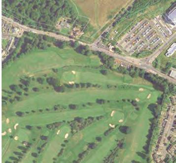
2 Introduction Springfield Properties plc (hereafter referred to as the Applicant ) is seeking planning permission in principle to redevelop Land at Edmonstone, The Wisp, South East Edinburgh (hereafter referred to as the Site ). The Site location and Site boundaries are indicated on Figure 1 and Figure 2 respectively. The scheme (hereafter referred to as the Development ) comprises a residential development of up to 750 units with a primary school, associated landscaping, utilities and roads. The Development is described in detail later in this document. An Environmental Impact Assessment (EIA) of the proposed Development has been undertaken. The methods used in carrying out the EIA, and its results and conclusions, are reported in an Environmental Statement (ES), which has been prepared to accompany the planning application. The ES describes the likely significant beneficial and adverse environmental impacts of the Development, together with a range of mitigation measures that would be implemented to prevent, reduce or offset any adverse environmental impacts. This document provides a summary of the ES findings in non-technical language. EIA Methodology EIA is a statutory process which aims to ensure that the potential environmental impacts, adverse and beneficial, of certain types of new development are taken into account when determining whether planning permission should be granted. The EIA of the proposed Development was undertaken in accordance with the Town and Country Planning (Environmental Impact Assessment) (Scotland) Regulations 2011 (the EIA Regulations ) using established methods and criteria, including site visits, surveys, data reviews, computer modelling and specialist assessments carried out by a qualified and experienced team of consultants. EIA Scoping is an important component of the EIA process which focuses the study (and hence the ES) on those issues of greatest potential significance. Scoping also ensures that all of the potentially significant impacts of the construction and operational phases of the Development are assessed at the design stage to ensure that the appropriate mitigation options were considered and incorporated into the scheme, as appropriate. The City of Edinburgh Council (CEC) was consulted by Waterman about the scope of the EIA in August CEC confirmed the issues to be covered by the EIA following consultation with the relevant environmental bodies including Scottish Natural Heritage (SNH), Historic Scotland and the Scottish Environment Protection Agency (SEPA). The EIA subsequently focused on these key issues, and the following sections of this document summarise the findings. Site Location and Setting As illustrated in Figures 1 and 2, the Site is located approximately 6km south-east of Edinburgh city centre, and to the north of the Moredun and Ferniehill areas of the city. Figure 3 shows the existing surrounding land uses. The Site extends to approximately 64.4 hectares (ha) and is bound to the east by The Wisp, an unclassified road, beyond which lies arable farmland. To the south by the remains of the derelict Edmonstone House and a mixture of publically accessible open land and woodland. The Site is bound to the south-west by the initial phases of the Edinburgh Bio-Quarter development, with the Edinburgh Royal Infirmary and a collection of biomedical research facilities beyond. The Site is bound to the north by a new residential development, New Greendykes, which is currently under construction. The initial phases of the New Greendykes development are already occupied and operational. Page 1 of 10
3 The suburban areas of Craigmillar, Greendykes and Niddrie are situated between 100m and 2km to the north. Residential properties forming the suburban area of Danderhall (within the jurisdiction of Midlothian Council) are located approximately 30m from the south-east corner of the Site, immediately to the east of The Wisp. Previous Land Use The Site was part of the extensive lands associated with the former Edmonstone House which is now derelict, and is located immediately south of the Site boundary. Historical maps indicate the Site was formerly in agricultural use, with farm buildings (Home Farm) located in the south east of the Site close to Edmonstone House. There is also a history of mining at the Site, particularly along the eastern edge of the Site, and quarrying in the north western tip of the Site. A former landfill has also been identified within the Site, and a mineral railway was formerly present on Site bisecting the Site from north to south. Historically, the surrounding area largely comprised agricultural fields; with former quarries, mines and mineral railways also identified in the vicinity of the Site. Existing Land Use and Activities The Site forms part of the wider Edmonstone Estate. The majority of the Site comprises rough open land with scattered areas of woodland. The southern part of the Site is characterised by scattered lone mature trees. A light industrial yard is located in a fenced off area within the eastern part of the Site, adjacent to The Wisp. The Category B Listed East Gate Lodge is located adjacent to The Wisp, in the south-eastern corner of the Site. An access road is currently under construction from a junction with The Wisp at the East Gate Lodge. The road follows the southern Site boundary and terminates at a former walled garden, adjacent to the south of the Site, which was part of the Edmonstone Estate. In the centre of the Site, a Public Transport Route, which is designed for buses to travel between the Edinburgh Royal Infirmary to the south-west and Craigmillar to the north, bisects the Site. The Niddrie Burn crosses the Site close to the public transport route, flowing from south-west to north-east. Two Core Paths and cycle routes traverse the Site, one along the same route as the Public Transport Route and another further to the north-west. A third Core Path and cycle route runs adjacent to the western boundary of the Site. These three routes connect Moredun and the Edinburgh Royal Infirmary in the south with Craigmillar and Greendykes in the north. An additional network of informal paths traverses the Site, and are frequently used by dog walkers and other recreational users. Parts of the Site currently suffer from vandalism and to fly-tipping. Alternatives In accordance with the EIA Regulations, the ES includes a discussion of the alternative development options considered by the Applicant. These options included no development, whereby the Site would be left in its current condition, a consideration of alternative site locations for the proposed Development, and an appraisal of alternative designs of the proposed Development. These are summarised below. No Development Alternative The no development alternative would result in the Site being left in its current state. This is not desirable for a number of reasons including that the Site is currently used informally by the surrounding communities Page 2 of 10
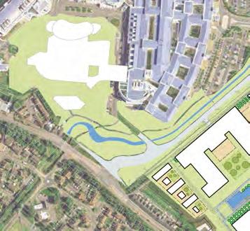
4 primarily for dog walking, although the relatively isolated and unmanaged nature of the Site with no formal access has led to the area becoming a focus for antisocial behaviour. This is reflected in fly-tipping and attempts to steal estate fencing. Furthermore, the woodland on and surrounding the Site has been long neglected and in certain areas subject to vandalism and arson which has caused irreversible damage to important trees. The proposed Development offers opportunities to appropriately manage and enhance the existing woodland areas. Leaving the Site undeveloped would also conflict with the need to provide more housing within Edinburgh to meet current shortages. In addition, the potential benefits to the local economy (such as new private and affordable housing, jobs, additional spending by new residents and contributions to community improvements such as education) would not be realised. For these reasons the Applicant wishes to develop the Site. Alternative Site Locations The Applicant has not considered alternative sites for the Development as residential development elsewhere would miss the opportunity to improve on the conditions within the Site, including its landscape characteristics and setting as part of the wider Edmonstone Estate; and the western part of the Site provides an opportunity to provide an area of community parkland with enhancements made to existing ecological habitats, landscapes and views. The Site also provides the opportunity to link the existing and emerging neighbourhoods of Craigmillar, Greendykes, Danderhall and Moredun. Alternative Scheme Design An early proposed design for residential-led development on the Site is presented as Figure 4. This design represented an initial concept for the Site. However, it was felt that further design evolution was needed to optimise the location of the proposed school and to maximise vehicular, pedestrian and cycle permeability through the Site. Nevertheless, many of the initial design concepts have been carried through to the currently proposed Development. The Proposed Development The proposed Development layout is shown in Figure 5 and described below. Up to 750 new residential units would be constructed within the Site. They would comprise a mix of semidetached, detached, terraced and flatted properties providing between one and five bedrooms. Building heights would be generally two storeys, with some blocks of four to six storeys. Each house would be provided with an element of private garden space and would benefit from significant open space in the vicinity. Parking would be provided in accordance with CEC requirements. A new primary school would be constructed in the south-eastern part of the Site. Public Realm, Landscaping and Ecological Enhancements The proposed landscape and public realm design for the Site focuses on the provision of generous publically accessible space through a series of linked open spaces, between individual Development plots. These areas would comprise predominantly grassed areas, both managed and unmanaged. In addition, tree, shrub and hedge planting would be provided throughout the Site to further enhance the Development and offer increased opportunities for biodiversity. New blocks of woodland are also proposed to reduce the visual impact of the Development as well as provide shelter and form part of an integrated structure of greenspace. Page 3 of 10
5 Access Access to the Development would be via three vehicular access points from the Wisp. The first would be the existing approved access road, currently under construction, from The Wisp in the south-east corner of the Site. The Site would take a second access point directly from the recently constructed Greendykes Third Access road, which forms the northern boundary of the Site, at a point approximately 100m west of The Wisp. The Site would have a third access point northwards onto a local road that in turn connects with the extended road that is partly formed by the Public Transport Route to the rear of Edinburgh Royal Infirmary This route connects northwards with Greendykes Road, in turn connecting with Niddrie Mains Road. Within the Site, a primary north-south route and a network of secondary streets and lanes would provide access to all building plots. The scale of these internal routes would enhance the sense of intimacy in the parts of the new neighbourhood away from the principal access routes. The Development would include a network of footpaths, suitable for both pedestrians and cyclists, which would connect the new residential areas within the Site both to each other and to the existing network of footpaths within the wider Edmonstone Estate and surrounding area. Public access to the woodland on Site and in the surrounding area would also be strengthened by the inclusion of new informal paths. In the western part of the Site, the existing Core Paths and cycle routes which cross the Site would be enhanced and included in a managed network of walking and cycle routes within this proposed area of community parkland. Regular bus services are provided along Old Dalkeith Road, south of the Site, and within Greendykes and Niddrie to the north, which would also provide travel options to new residents. A limited bus service also runs along The Wisp to the east of the Site. The recently developed Public Transport Route which connects the Royal Infirmary with New Greendykes crosses through the middle of the Site and affords the opportunity for future access to bus routes connecting with Edinburgh city centre. Existing and proposed pedestrian links within and surrounding the Site would provide easy access to such services in the vicinity of the Development. Construction The construction activities associated with the proposed Development would comprise the following broad overlapping stages: Enabling works, including stabilisation of underground mine-workings if necessary; Highway works; Construction works; and Landscaping. It is currently anticipated that the Development would commence towards the end of 2017 at the earliest and be complete by The Contractor would be required to prepare a Site-specific Construction Environmental Management Plan (CEMP). The preparation of a CEMP is an established method for managing potential environmental impacts of construction works and is consistent with methods adopted for other major schemes. The CEMP would be an operational manual for carrying out environmental controls and monitoring during works, and would include reference to essential standards for dealing with, for example, waste and materials, air quality, noise and ecological resources. The CEMP would include: Page 4 of 10
6 Restrictions and targets for specific work activities to minimise environmental impacts, including disruption and disturbance to local residents, workers and the visitors to the Site; Details of the means by which appropriate environmental monitoring, record keeping and reporting would be managed to ensure the above targets are being met; Measures to address traffic and access management, including a Construction Traffic Management Plan (CTMP); Procedure(s) to deal with any necessary abnormal works that could result in deviation from the agreed procedures and targets; and Provision of a programme of regular environmental audits and reviews at key stages in the construction programme. Socio Economics A socio-economics assessment was undertaken to assess the likely impacts of the Development on the local and regional economy. In particular, the assessment considered the effects of the Development on employment and economic output. The assessment concluded that the following quantifiable impacts could benefit the local area as a result of the proposed Development: Approximately 75million new capital investment; In the region of 372 man years of construction employment, of which almost 250 accruing at the regional level and injecting an additional 16.5 million into the regional economy; New primary school creating in the region of 25 new jobs; Around 975 new residents from outwith the City of Edinburgh, generating an additional 2.0 million per annum in new Council Tax receipts; and An additional 5.5 million per annum in retail spend. No adverse impacts were predicted to arise as a result of the proposed Development. Transportation and Access A Transport Assessment has been undertaken for the proposed Development, which showed that the road network surrounding the Site currently operates within capacity and would continue to do so following completion of the Development. The implementation of a CEMP and a CTMP during construction would ensure that appropriate control measures are enforced. No significant environmental impacts would therefore be likely as a direct result of construction vehicles (e.g. HGVs) accessing the Site. Once the proposed Development is operational, no adverse impacts are predicted on the road links surrounding the Site. No significant issues would be likely in terms of accidents and safety; disruption and driver delay; fear, intimidation and pedestrian amenity; or severance during the construction and operational phases of the proposed Development. Current public transport access to the Site is provided by regular bus services along Old Dalkeith Road to the south and Greendykes Road to the north, which would provide travel options to new residents of the Development. Sufficient capacity is expected to exist on existing bus services to accommodate the needs of the Development. Page 5 of 10
7 Noise and Vibration An assessment of the impacts of the construction works, together with the operation of the completed Development, was undertaken in relation to a number of existing noise and vibration-sensitive receptors in the vicinity of the Site (e.g. nearby residential properties in New Greendykes, Craigmillar and Danderhall). A preliminary assessment for the proposed school was also undertaken. Baseline noise surveys revealed that the existing noise climate on and in the vicinity of the Site is dominated by road traffic noise from the local highway network. An assessment of noise from helicopters associated with the Royal Infirmary of Edinburgh was also undertaken. During construction, measures to control noise and vibration would be enforced through the CEMP. As a consequence, the construction works would generally proceed with minimum disturbance to local residents. Nevertheless, some short term disturbance may be experienced at sensitive receptors such as future dwellings within the Site over the course of the phased development, or at the New Greendykes development. No noticeable adverse impacts from vibration are predicted as a result of the construction works. Measures to reduce noise within new properties from existing road traffic and intermittent helicopter noise associated with the nearby Edinburgh Royal Infirmary would include the provision of appropriate sound insulated window glazing and ventilation systems. No significant adverse impacts are anticipated. Air Quality During construction works, it would be usual to expect that dust would be generated by activities at the Site. Any elevated levels of dust would be temporary and would be influenced by the type of activity taking place. Nevertheless, the potential for adverse impacts at residential units on and in proximity to the Site is recognised. Best practice measures would therefore be implemented by construction contractors to minimise the risk of dust causing a potential nuisance for local residents. These measures would form part of the CEMP and are likely to include: dust monitoring at sensitive locations; damping down surfaces during dry weather; covering construction materials and stockpiles; sheeting of material laden vehicles leaving the Site; regular cleaning of frequently used areas; and limiting on-site vehicle speeds. Measures such as these are routinely and successfully applied to construction projects throughout the UK and significantly reduce the potential for dust effects. Exhaust emissions from construction plant would be minimised by avoiding high levels of vehicle movements during peak hours on the local road network in accordance with the CEMP. The Site is not within or close to an Air Quality Management Area (AQMA) and the local air quality is generally good, with no recent exceedances of target levels for nitrogen dioxide (NO2) or particulate matter (PM10), pollutants generally associated with vehicle emissions. Emissions of NO2 and PM10 from vehicles associated with the completed Development are predicted to have negligible impacts on local air quality. Nevertheless, a Travel Plan would be provided to future residents to encourage car sharing to reduce the number of car trips associated with the Development, and encourage walking and cycling and use of public transport, which would also reduce emissions to air. Page 6 of 10
8 Landscape and Visual Impact A landscape and visual assessment was undertaken and identified a number of viewpoints from which impacts of the Development should be considered. These ranged from local views both within, and adjacent to, the Site to more distant views from notable features such as Craigmillar Castle, Queen s Drive and Edinburgh Castle. The landscape character and quality of the Site is greatly influenced by the cumulative impact of the planned developments in the surrounding area, particularly at Greendykes and the BioQuarter, which will change from neglected open farmland to dense urban development. The proposed development would be part of this process of change. The Edmonstone Ridge, which is an important element in the setting of the city, would contain the proposed development. Furthermore, existing woodland would be substantially retained and new woodland planting on The Wisp Ridge would also contain the Development, protecting views to the east and improve the setting of the city. Proposed new belts of woodland combined with existing planting would provide a strong green structure to contain the Development and reduce the impact of the built mass. Some adverse impacts are predicted due to the change in the Site from undeveloped land to a residential area. Significant landscape and visual impacts are predicted from viewpoints such as Edinburgh Castle, Queen s Drive and nearby developments at Greendykes and for northbound traffic on The Wisp. However wide views to the Firth of Forth would not be significantly affected, and there are no adverse impacts predicted on views towards the Site from Shawfair and North Danderhall.. The site of the Home Farm Scheduled Monument would not be affected by built development. The Site is currently used for casual recreation, and the proposed development would maintain opportunities for this activity. The network of footpaths and cycleway currently proposed for Little France Park can be incorporated into the layout of the Development. In common with other developments in the area, mainly the Royal Infirmary of Edinburgh and the BioQuarter, the Development would reduce the extent of greenspace originally envisaged for the South East Wedge. However, the essential links to Moredun, Danderhall, Shawfair, Hawkhill, Craigmillar Country Park, the Niddrie Burn Corridor and Hunter s Hall Park would be maintained to enable the strategic functions of the greenspace. Archaeology and Cultural Heritage The Site contains designated heritage assets of high value, including one Category B Listed Building, two Scheduled Monuments and a Listed Garden and Designed Landscape. It also contains non-designated heritage assets of high significance and of regional importance. There is a high potential for there to be hitherto undiscovered evidence within the Site relating to these known assets. Previous archaeological excavations ahead of other proposed development works in the immediate vicinity of the Site, have revealed extensive related evidence. It is therefore highly likely that the Site will also contain related evidence, most likely associated with the designed landscape of Edmonstone House, previous mining works and Medieval agricultural activity such as rig and furrow. It is also likely that Prehistoric remains may be encountered given that the Site contains a Scheduled Monument relating to prehistoric enclosures. It is recommended that, prior to the commencement of construction, a full historic landscape survey is undertaken to fully record the surviving elements of the designed landscape associated with Edmonstone House within the Site. A phased programme of archaeological investigation is then recommended across areas of proposed housing and along routes of roads, drains and services. This would most likely be a Page 7 of 10
9 trench evaluation followed by strip, map and sample of areas identified in the evaluation as containing significant archaeological features. Areas within the Development which are to be maintained as parkland should not be subject to landscaping without prior archaeological investigation. If footpaths or cycle paths are to be created within the parkland, these should be subject to an archaeological watching brief during construction, or other appropriate archaeological investigation, to be informed by the initial historic landscape survey. A Management Plan should be put in place to ensure that footpath erosion in areas of parkland or greenspace, especially within a Scheduled Monument, is monitored and controlled as it could truncate shallow deposits or features. The detailed design of the proposed Development should aim to preserve trees which were part of the designed landscape, as well as those which are remnants of Post Medieval field boundaries. The Site is visible from Craigmillar Castle and the inter-visibility between the Castle and the Site of Edmonstone House is a key factor in the setting of both assets. It is recommended that inter-visibility between the two sites is maintained to preserve this aspect of the historic landscape. Ground Conditions and Water Resources Geology underlying the Site is recorded to largely comprise made ground (sandy clay with cobbles and rock fragments with traces of brick, timber, metal and ceramics) over Glacial Till (soft to firm becoming stiff clay with silt and pockets of sand) and Fluvio-Glacial Deposits (dense sand with gravels and cobbles). Rock is described as coarse sandstone with beds of coal throughout. The Site has been extensively worked in the past, with one mine entry recorded on Site or within 20m of the Site, and a number of coal seams are identified in the vicinity of the Site. A Flood Risk Assessment (FRA) undertaken in 2015 identified four surface water features on Site (the Niddrie Burn, two irregular ponds, and a drainage channel). Given the topography of the Site and lack of springs within the Site, the Site is not considered to be at significant risk of groundwater flooding. In addition, there is not considered to be a significant risk of flooding from sewers and water mains. The FRA identified a limited risk of surface water flooding from excess runoff from adjacent land. However, as the Site is situated on sloping ground, there is considered to be a risk of flooding within the Site if there was a blockage or failure of the future on-site drainage system. No development is proposed in these areas, and through design, and sustainable drainage (SUDS) measures to control surface runoff quality, no significant impacts from flooding are anticipated. A number of best practice measures are recommended in order to reduce the risk of exposure to contamination in soils or water resources. To address the issue of mine-workings beneath and in the vicinity of the Site, the on-site mineshaft and its surrounding area would be subject to an exclusion zone and stabilisation works as required. A programme of contamination testing and gas monitoring would also be undertaken if necessary. During construction, the implementation of a CEMP would control and reduce potential impacts from contamination to surface water resources, soils and groundwater, buried structures and services, as well as visitors to the Site. The use of appropriate protective equipment at all times by construction personnel would ensure that contact with potentially contaminated soils is controlled. The CEMP would also incorporate measures controlling dewatering of excavations in the event that this would be required during construction. Site works would be programmed to be undertaken during appropriate weather conditions. Areas of open space and landscaping would be restored, including topsoil improvement if necessary. Page 8 of 10
10 Impacts on the completed Development would be prevented through the excavation and disposal of any contaminated soils at a suitably licensed waste management facility or, alternatively, the covering of contaminated soils below new areas of hardstanding to prevent contact with Site users. Further assessment is proposed to determine the requirement for ground gas measures and any additional measures required in relation to landscaping and construction of gardens, and to determine the route of proposed potable water supplies. Ecology An ecological survey was undertaken in August 2015 to determine the value of habitats, flora and fauna on the Site. Parts of the Site are designated as Local Biodiversity Sites (LBS). The construction of the Development is predicted to have no significant impacts on the ecology of the Site. Any potential impacts on ecology or the integrity of the LBS would be managed via a site-specific EMP which would be followed during construction. It is considered that the completed Development is unlikely to lead to significant adverse effects in relation to most terrestrial ecology. However, with a lack of sufficient data on breeding bird activity within the Site, the potential impacts and residual impacts of the proposed Development upon breeding birds using the Site cannot be accurately assessed. As such, a series of breeding bird surveys are recommended to assess such activity within the Site, allowing potential impacts to be accurately assessed. Further habitat surveys are also recommended for the areas of the Edmonstone LBS which would be lost to the Development in order to complete the assessment. With the exception of breeding birds and notable plant species of the LBS which at this stage, have not been fully assessed at this time, it is considered that where impacts may arise, these can be managed by implementing proposed mitigation and enhancement measures for the key species concerned. This would include monitoring and managing the LBS and woodland on Site, to protect these areas from fly-tipping and littering. Cumulative Impacts An assessment of the likely environmental impacts of the proposed Development in combination with each other and also with those of other schemes in the surrounding area was undertaken. These cumulative schemes included the adjacent consented Edmonstone Polices and Eight Acre Field/ Walled Garden residential developments to the south of the Site, the Edinburgh Bioquarter (under construction adjacent to the south of the Site),and the consented Royal Hospital for Sick Children (1km south of the Site). These two types of impact are described below: Type 1 impacts: Combined impacts of individual impacts arising from the Development during construction, for example noise, dust and visual impacts on a particular receptor; and Type 2 impacts: the combined impacts from the Development and the cumulative schemes, which when considered together could amount to a significant cumulative impact. For Type 1 cumulative impacts it is envisaged that during construction works, dust, noise and visual intrusion could arise in combination for some receptors. However, these impacts would be reduced through effective Site management practices, implemented via a CEMP for the proposals. Cumulative impacts were assessed for the proposals in combination with four other proposed schemes within the surrounding area. Generally, it is considered unlikely that significant adverse cumulative impacts would occur during construction. The exception would be in terms of noise and vibration where cumulative Page 9 of 10
11 impacts are predicted to occur where elements of the proposed Development are under construction simultaneously with adjacent cumulative schemes. However, it should be noted that such events would be occasional, limited to the proximity of the Site boundaries and representative of a worst case scenario. Beneficial cumulative socio-economic impacts are predicted during the construction phase. In the case of the completed Development, in general, no significant adverse cumulative impacts are anticipated due to negligible impacts being predicted for the Development in isolation or the lack of interconnection between sites. However, there are predicted to be, at worst, minor adverse cumulative impacts to the settings of heritage assets identified on and in the vicinity of the Site. Beneficial cumulative socioeconomic impacts are again predicted once the proposed Development is operational. ES Availability and Comments The ES is available for viewing by the public during normal office hours at the CEC Planning Department. It is also available on CEC s online planning portal. Comments on the planning application should be submitted through the planning portal or forwarded to CEC at the following address: City of Edinburgh Council Tel: Planning and Building Standards Waverley Court 4 East Market Street Edinburgh EH8 8BG Additional copies of this are available free of charge. Copies of the full ES are available for purchase in both CD-ROM and paper format (price on application). For copies of these documents, please contact: Waterman Infrastructure & Environment Ltd Tel Third Floor, South Suite 8 Nelson Mandela Place Glasgow G2 1BT Page 10 of 10

12 SITE LOCATION N Project Details Figure Title WIE : Land at Edmonstone, The Wisp, South East Edinburgh Figure 1: Site Location Figure Ref Date File Location WIE _GR_ES_1.1A 2016 \\s-lncs\wiel\projects\wie10135\100\graphics\es\issued figures WATERMAN INFRASTRUCTURE & ENVIRONMENT Reproduced from the Ordnance Survey maps with the permission of the Controller of Her Majesty s Stationery Office, Crown copyright, Waterman Infrastructure & Environment, Pickfords Wharf, Clink Street, London SE1 9DG. Licence number LAN
13 Planning Application Boundary N Project Details Figure Title WIE : Land at Edmonstone, The Wisp, South East Edinburgh Figure 2: Planning Application Boundary Source: EMA Architects WATERMAN INFRASTRUCTURE & ENVIRONMENT Reproduced from the Ordnance Survey maps with the permission of the Controller of Her Majesty s Stationery Office, Crown copyright, Waterman Infrastructure & Environment, Pickfords Wharf, Clink Street, London SE1 9DG. Licence number LAN Figure Ref Date File Location WIE _GR_ES_1.2A 2016 \\s-lncs\wiel\projects\wie10135\100\graphics\es\issued figures
14 Planning Application Boundary Residential Open Land / Park / Golf Woodland Agricultural Light Industrial Craigmillar Castle School Medical R & D (Existing and Proposed) Hospital New Greendykes Masterplan (currently under construction) N Project Details WIE : Land at Edmonstone, The Wisp, South East Edinburgh Figure Title Figure 3: Predominant Land Uses Figure Ref WIE _GR_ES_3.1A Date 2016 File Location \\s-lncs\wiel\projects\wie10135\100\graphics\es\issued figures Source: EMA Architects WATERMAN INFRASTRUCTURE & ENVIRONMENT Reproduced from the Ordnance Survey maps with the permission of the Controller of Her Majesty s Stationery Office, Crown copyright, Waterman Infrastructure & Environment, Pickfords Wharf, Clink Street, London SE1 9DG. Licence number LAN


15 1 Woodland Planting Development Pockets Footpath / Cyclepath Vehicular Access POTENTIAL SCHOOL SITE 4 8 N Project Details Figure Title WIE : Land at Edmonstone, The Wisp, South East Edinburgh Figure 4: Previous Alternative Scheme Design Source: EMA WATERMAN INFRASTRUCTURE & ENVIRONMENT Reproduced from the Ordnance Survey maps with the permission of the Controller of Her Majesty s Stationery Office, Crown copyright, Waterman Infrastructure & Environment, Pickfords Wharf, Clink Street, London SE1 9DG. Licence number LAN Figure Ref Date File Location WIE _GR_ES_4.1A 2016 \\s-lncs\wiel\projects\wie10135\100\graphics\es\issued figures

16 HUNTER S HALL PARK Planning Application Boundary CRAIGMILLAR CASTLE PARK PROPOSED ERI PARKING GREENDYKES ERI PARKING EDMONSTONE PARK THE WISP MILLERHILL ROAD EDINBURGH ROYAL INFIRMARY S.A.M LIBERTON GOLF COURSE A7 WALLED GARDEN 8 ACRE FIELD EDMONSTONE POLICIES DANDERHALL N DRUM ESTATE Project Details Figure Title WIE : Land at Edmonstone, The Wisp, South East Edinburgh Figure 5: Proposed Development Layout A7 Figure Ref Date WIE _GR_ES_4.3A 2016 Source: EMA File Location \\s-lncs\wiel\projects\wie10135\108\graphics\es\issued figures WATERMAN INFRASTRUCTURE & ENVIRONMENT Reproduced from the Ordnance Survey maps with the permission of the Controller of Her Majesty s Stationery Office, Crown copyright, Waterman Infrastructure & Environment, Pickfords Wharf, Clink Street, London SE1 9DG. Licence number LAN
17
Replacement Golf Course Facilities and Residential Development, Churston. Environmental Statement Non-Technical Summary
 Replacement Golf Course Facilities and Residential Development, Churston Environmental Statement Non-Technical Summary July 2011 Reproduced from the Ordnance Survey s map with the permission of the Controller
University Park, Worcester Non Technical Summary December 2011
 University Park, Worcester Non Technical Summary December 2011 Introduction UW Wrenbridge LLP, a Joint Venture Company of the University of Worcester and Wrenbridge Land Ltd (the Applicants ) intend to
Dolphingstone Farm, Prestonpans Environmental Statement. Non-Technical Summary. June Waterman Energy, Environment & Design Limited
 Dolphingstone Farm, Prestonpans Environmental Statement June 2015 Waterman Energy, Environment & Design Limited Third Floor, South Suite, 8 Nelson Mandela Place, Glasgow, G2 1BT, United Kingdom Introduction
BREEDON NORTHERN LIMITED
 Non Technical Summary CONTENTS 1 INTRODUCTION... 1 2 SITE DESCRIPTION... 1 3 DESCRIPTION OF THE DEVELOPMENT... 6 4 NEED FOR THE DEVELOPMENT... 8 5 KEY ISSUES CONSIDERED IN THE ENVIRONMENTAL IMPACT ASSESSMENT...
Longbridge Town Centre Phase 2 Planning Application
 Longbridge Town Centre Phase 2 Planning Application Non-Technical Summary of the Environmental Statement December 2013 Introduction A full application for Planning Permission has been submitted to Birmingham
Grantham Southern Quadrant Link Road Environmental Statement
 Grantham Southern Quadrant Link Road Environmental Statement Non Technical Summary Introduction Lincolnshire County Council (LCC) is submitting a planning application for the proposed implementation of
DEFGH. Crystal Place Park. Environmental Impact Assessment (EIA) Elin Thomas and Emily Low Waterman Environmental
 Elin Thomas and Emily Low Waterman Environmental") DEFGH Crystal Place Park Environmental Impact Assessment (EIA) Elin Thomas and Emily Low Waterman Environmental 10.12.07 EIA Presentation Content What is EIA? Legal Requirements Process Q&A Key Topics
DEFGH Crystal Place Park Environmental Impact Assessment (EIA) Elin Thomas and Emily Low Waterman Environmental 10.12.07 EIA Presentation Content What is EIA? Legal Requirements Process Q&A Key Topics
LITTLE FRANCE PARK, EDINBURGH
 LITTLE FRANCE PARK, EDINBURGH INTEGRATING ACTIVE TRAVEL ROUTES WITHIN A MASTERPLAN FROM THE OUTSET Location: Implemented: Edinburgh, Scotland 2016 - ongoing CASE STUDY The Little France Park cycling and
LAND AT HOWES LANE, BICESTER ENVIRONMENTAL STATEMENT NON-TECHNICAL SUMMARY. March 2017 Our Ref: Q70433
 LAND AT HOWES LANE, BICESTER ENVIRONMENTAL STATEMENT NON-TECHNICAL SUMMARY March 2017 Our Ref: Q70433 Contents 1 INTRODUCTION AND SITE DESCRIPTION... 1 2 EIA METHODOLOGY... 5 3 ALTERNATIVES... 6 4 DESCRIPTION
LAND SECURITIES REDEVELOPMENT OF NEWNHAM COURT SHOPPING VILLAGE, MAIDSTONE
 LAND SECURITIES REDEVELOPMENT OF NEWNHAM COURT SHOPPING VILLAGE, MAIDSTONE Land at Environmental Statement: Non-Technical Summary Introduction Land Securities plc is applying to Maidstone Borough Council
LONDON BRIDGE STATION ENVIRONMENTAL STATEMENT NON-TECHNICAL SUMMARY
 LONDON BRIDGE STATION ENVIRONMENTAL STATEMENT NON-TECHNICAL SUMMARY June 2011 1 EXECUTIVE SUMMARY 2 INTRODUCTION CONTENTS Page 2.1 Introduction 4 2.2 The Site 4 3 THE DEVELOPMENT 3.1 What is it? 5 3.2
South Whitehaven, Cumbria EIA
 South Whitehaven, Cumbria EIA Environmental Statement - Non Technical Summary June 2013 in association with 1. Introduction Story Homes is applying to Copeland Borough Council (CBC) for a new residential
NON-TECHNICAL SUMMARY
 Proposed Sand and Gravel Extraction and Associated Processing Operations with Restoration to a Mixture of Agriculture and Nature Conservation including Areas of Shallow Water at Hedgeley, Northumberland
Barvills Solar Farm Environmental Statement Non-Technical Summary
 Barvills Solar Farm Environmental Statement Non-Technical Summary 13 March 2015 Produced for Prepared by St John s House Queen Street, Manchester M2 5JB Contents Contents... 2 1 Introduction... 3 1.1 Development
ES 5. Drakelow Park. Environmental Statement. Volume 5: Non Technical Summary. Lead Author Waterman Energy, Environment and Design Ltd
 Drakelow Park ES 5 Environmental Statement Volume 5: Non Technical Summary Lead Author Waterman Energy, Environment and Design Ltd April 2009 Environmental Statement Volume 5: Non-Technical Summary DRAKELOW
London Road, Derker. Non Technical Summary. Introduction
 London Road, Derker Non Technical Summary Introduction The Oldham Rochdale Housing Market Pathfinder was set up to tackle longstanding problems of poor quality housing and to provide the framework for
The Place Solar Farm
 The Place Solar Farm Environmental Statement Non-Technical Summary 28 August 2014 Produced for Prepared by St John s House Queen Street, Manchester M2 5JB Contents Contents... 2 1 Introduction... 3 1.1
Kirkcaldy South West. Invertiel and Tyrie Farms. Environmental Statement Non Technical Summary. Volume 1
 Kirkcaldy South West Environmental Statement Non Technical Summary Volume 1 Invertiel and Tyrie Farms August 2010 CALA Homes (East) Ltd and Mactaggart & Mickel Ltd Volume 1 Non Technical Summary Contents
LAND AT MIDDLETON STONEY ROAD AND HOWES LANE, BICESTER ENVIRONMENTAL STATEMENT NON-TECHNICAL SUMMARY. June 2017 Our Ref: Q70433
 LAND AT MIDDLETON STONEY ROAD AND HOWES LANE, BICESTER ENVIRONMENTAL STATEMENT NON-TECHNICAL SUMMARY June 2017 Our Ref: Q70433 Contents 1 INTRODUCTION... 2 2 SITE DESCRIPTION... 5 3 EIA METHODOLOGY...
Welcome to our exhibition
 Welcome to our exhibition The Homes & Communities Agency (HCA) welcomes you to this public exhibition explaining our proposals for the redevelopment of the former Lea Castle Hospital site. About the Homes
Perth and Kinross Council Development Management Committee 8 June Pre-Application Report by Development Quality Manager
 Perth and Kinross Council Development Management Committee 8 June 2016 5(3)(i) 16/259 Pre-Application Report by Development Quality Manager Residential development at St Martins Road, Land 120 metres West
Meridian Water Phase 1 Application
 Meridian Water Phase 1 Application MW11 Environmental Statement Non-Technical Summary London Borough of Enfield March 2016 Contents 1 Introduction 1 2 The proposed development 2 3 Evolution of the proposed
Cardiff International Sports Village Waterfront Development Volume IV : Non-Technical Summary of the Environmental Statement
 Greenbank Partnerships Ltd October 2012 Cardiff International Sports Village Waterfront Development Volume IV : Non-Technical Summary of the Environmental Statement Environmental Statement - Non Technical
Wyvern Park Skipton Environmental Statement. Non-technical Summary - April 2015
 Wyvern Park Skipton Environmental Statement Non-technical Summary - April 2015 BWB Consulting Ltd Whitehall Waterfront 2 Riverside Way Leeds LS1 4EH Telephone: +44(0)113 233 8000 Copyright This Report
Request for a Scoping Opinion by Provectus. Proposed Surface Mining of Coal on Land west off the A61, Hill Top Farm, Clay Cross, Derbyshire
 Request for a Scoping Opinion by Provectus Proposed Surface Mining of Coal on Land west off the A61, Hill Top Farm, Clay Cross, Derbyshire January 2012 Contents 1 Introduction & Background... 1 2 Site
NON-TECHNICAL SUMMARY. October 2017 CLARENDON GAS WORKS WOOD GREEN
 NON-TECHNICAL SUMMARY October 2017 CLARENDON GAS WORKS WOOD GREEN CLARENDON GAS WORKS, HARINGEY ENVIRONMENTAL STATEMENT NON-TECHNICAL SUMMARY October 2017 Our Ref: Q70251 Contents 1 INTRODUCTION... 2 2
Former RAF Sealand Site EIA
 Praxis (Holdings) Ltd. Former RAF Sealand Site EIA Environmental Statement - Non Technical Summary February 2012 in association with P a g e 1 1. Introduction Praxis (Holdings) Ltd. is applying to Flintshire
This document provides a summary of the ES findings in non-technical language.
 Introduction MOTO Hospitality Limited (the Applicant ) is seeking full planning permission to redevelop the Kinross Motorway Service Area (the Site ) located at Turfhills, near Kinross, west of Junction
Proposed World-Class Hotel at Former Royal High School, Regent Road, Edinburgh
 Duddingston House Properties and Urbanist Hotels Proposed World-Class Hotel at Former Royal High School, Regent Road, Edinburgh Environmental Statement Non-Technical Summary 3rd September 2015 www.oldroyalhighschool.com
The Haymarket 189 Morrison Street, Edinburgh. Environmental Statement. Volume 1 Non Technical Summary
 The Haymarket 189 Morrison Street, Edinburgh Environmental Statement Volume 1 Non Technical Summary 16 August 2010 Tiger Haymarket Limited Partnership Non Technical Summary Contents 1 Introduction 1 2
Land at BROOK STREET PROPERTIES TENCREEK FARM, LISKEARD. Environmental Statement: Non-Technical Summary
 BROOK STREET PROPERTIES TENCREEK FARM, LISKEARD Land at Environmental Statement: Non-Technical Summary Introduction Brook Street Properties is applying to Cornwall Council for outline planning permission
1 SUMMARY OF APPLICATION AND RECOMMENDED DECISION
 SPECIAL PLANNING COMMITTEE TUESDAY 5 DECEMBER 2017 ITEM NO 4.1 APPLICATION FOR PLANNING PERMISSION IN PRINCIPLE 14/00910/PPP FOR RESIDENTIAL DEVELOPMENT, ERECTION OF PRIMARY SCHOOL AND MIXED USE DEVELOPMENT
Welcome to our public exhibition
 About our development Welcome to our public exhibition This exhibition gives you the chance to view and comment on our proposals for a new residential development of 165 high-quality homes, along with
Moat Lane Regeneration Project Environmental Statement
 AECOM Environment Towcester Regeneration Ltd. October 2012 Moat Lane Regeneration Project Environmental Statement Non-Technical Summary Prepared by:... Checked by:... Sophie Collins Scott Wilson Environmental
1 INTRODUCTION 1.1 INTRODUCTION
 1 INTRODUCTION 1.1 INTRODUCTION RREEF (UK) Ltd in partnership with Sheffield City Council (SCC) is applying for planning permission for the construction of: a new indoor city centre market hall and indoor
Former North Works, Lickey Road, Longbridge, Birmingham
 Committee Date: 14/11/2013 Application Number: 2013/06431/PA Accepted: 27/08/2013 Application Type: Full Planning Target Date: 26/11/2013 Ward: Longbridge Former North Works, Lickey Road, Longbridge, Birmingham
ABBEY MANOR GROUP/SAINSBURY S SUPERMARKETS LTD
 ABBEY MANOR GROUP/SAINSBURY S SUPERMARKETS LTD Mixed Use Development including Business Park and Foodstore Land at Bunford Park, Bunford Lane, Yeovil Environmental Statement: Non-Technical Report June
Land to the North of Main Road, Wybunbury
 Land to the North of Main Road, Wybunbury Environmental Statement Non-Technical Summary November 2014 Land to the North of Main Road, Wybunbury Environmental Statement Non-Technical Summary Prepared on
PANSHANGER QUARRY, Hertfordshire
 PANSHANGER QUARRY, Hertfordshire Proposed enhanced restoration of Phases F & H Briefing Note 1 March 2015 INERT (INACTIVE) RESTORATION MATERIALS, CONTROLS AND OPERATIONS 1 Introduction This briefing note
Public Consultation. Land at Monks Farm, North Grove. Welcome
 Welcome Welcome to our public exhibition for development on Land at Monks Farm, orth Grove. Gallagher Estates and Gleeson Strategic Land are preparing an outline planning application for new homes, open
I539. Smales 2 Precinct
 I539. Smales 2 Precinct I539.1. Precinct Description The Smales 2 Precinct applies to a 4.8 hectare block of land located on the southern side of Northcote Road and fronting Lake Pupuke, Takapuna. The
Cranbrook EXPANSION ENVIRONMENTAL STATEMENT: NON-TECHNICAL SUMMARY PRODUCED BY DAVID LOCK ASSOCIATES
 Cranbrook EXPANSION ENVIRONMENTAL STATEMENT: NON-TECHNICAL SUMMARY PRODUCED BY DECEMBER 2014 CRANBROOK EXPANSION AREAS ENVIRONMENTAL STATEMENT NON TECHNICAL SUMMARY Submitted in support of Outline Planning
Rochford District Council Allocations Development Plan Document: Discussion and Consultation Document Sustainability Appraisal
 Option SWH1 Balanced Communities Option SWH1 1 To ensure the delivery of high quality sustainable communities where people want to live and work Will it ensure the phasing of infrastructure, including
Development of land adjacent to Braggs Farm Lane and Rumbush Lane, Dickens Heath. Welcome. Today s exhibition. The proposal site
 Welcome Welcome to this event to discuss the development of land adjacent to Braggs Farm Lane. is currently in the preliminary stages of designing proposals to sensitively develop this site with high-quality
BRIDGE OF DON MASTERPLAN & PLANNING SUMMARY
 BRIDGE OF DON MASTERPLAN & PLANNING SUMMARY SITE LOCATION The site of the existing AECC lies in an area of predominately residential and business use in Bridge of Don and extends approximately 50 acres.
17A. Wind Microclimate
 17A. Wind Microclimate 17A.1 Introduction 17A.1.1 17A.1.2 17A.1.3 17A.1.4 This Chapter, which has been prepared by Waterman and BMT, provides further information with regard to the potential wind microclimate
Longbridge East : Site Wide and Phase One Development
 Longbridge East : Site Wide and Phase One Development Non-Technical Summary of the August 2011 Introduction St Modwen Developments Ltd intend to submit a new outline planning application for Longbridge
Harrow Lane, St Leonards-on-Sea, East Sussex, TN37 7JZ ERECTION OF 113 DWELLINGS TOGETHER WITH ESTATE ROADS (DETAILED SUBMISSION)
") AGENDA ITEM NO: Report to: PLANNING BOARD Date: 10 September, 2003 Report from: Borough Planning Officer Application Address: Proposal: Application No: Recommendation: Ward: File No: Applicant: Interest:
AGENDA ITEM NO: Report to: PLANNING BOARD Date: 10 September, 2003 Report from: Borough Planning Officer Application Address: Proposal: Application No: Recommendation: Ward: File No: Applicant: Interest:
Sustainability Statement. Whitby Business Park Area Action Plan
 Sustainability Statement Whitby Business Park Area Action Plan November 2014 Contents Page 1. Introduction 1 2. Scoping 3 3. Sustainability Appraisal of Options 6 4. Assessment of Draft Area Action Plan
WELCOME GYPSY LANE. Wider Site Location plan. Proposals for the development of LAND OFF FOXLYDIATE LANE WEBHEATH. Proposals for the development of
 WELCOME The developers are preparing an outline planning application for a residential led development and need the community s views in order to develop the proposals further WHAT IS PROPOSED? A high
WELCOME. Welcome and thank you for visiting today.
 WELCOME Welcome and thank you for visiting today. Bellway Homes Ltd (Yorkshire) are preparing a reserved matters planning application for a residential development of 293 homes at land North of Yew Tree
Non-technical summary
 Non-technical summary Introduction NTS.1 is applying for outline planning permission for a residential development of up to 80 dwellings on land at Hambrook, on the northern fringe of Bristol. NTS.2 An
Newcourt Masterplan. November Exeter Local Development Framework
 Newcourt Masterplan November 2010 Exeter Local Development Framework Background The Exeter Core Strategy Proposed Submission sets out the vision, objectives and strategy for the development of Exeter up
Chapter 4. Route Window C12: Mile End Park and Eleanor Street Shafts
 Chapter 4 Route Window C12: Mile End Park and Eleanor Street Shafts 48 Crossrail Amendment of Provisions 4 Route Window C12: Mile End Park and Eleanor Street Shafts Location plan of Mile End Park and Eleanor
Site ref: AS06 Site Name or Address: Murreys Court, Agates Lane
 Site ref: AS06 Site Name or Address: Murreys Court, Agates Lane Proposed Land Use: Total Site Area (Ha): Housing 1.85 Ha Description: It is understood that the owner has no plans to dispose of the site
PERSIMMON HOMES (SW) LIMITED LAND AT ADDINGTON, LISKEARD ENVIRONMENTAL STATEMENT NON-TECHNICAL SUMMARY
 LIMITED LAND AT ADDINGTON, LISKEARD ENVIRONMENTAL STATEMENT NON-TECHNICAL SUMMARY") PERSIMMON HOMES (SW) LIMITED LAND AT ADDINGTON, LISKEARD ENVIRONMENTAL STATEMENT NON-TECHNICAL SUMMARY APRIL 2010 INTRODUCTION This document is the Non-Technical Summary (NTS) of an Environmental Statement
PERSIMMON HOMES (SW) LIMITED LAND AT ADDINGTON, LISKEARD ENVIRONMENTAL STATEMENT NON-TECHNICAL SUMMARY APRIL 2010 INTRODUCTION This document is the Non-Technical Summary (NTS) of an Environmental Statement
ABOUT CALA HOMES CALA HOMES
 WELCOME Welcome to this public consultation event for our proposed development on land to the east of Salisbury Road, in Hungerford. Thank you for taking the time to come along today. Homes and Wates Developments
CA//16/00504/FUL. Canterbury City Council Military Road Canterbury Kent CT1 1YW. Crown copyright and database rights 2016 Ordnance Survey
 O Scale 1:1,250 Map Dated: 09/05/2016 CA//16/00504/FUL Crown copyright and database rights 2016 Ordnance Survey 100019614 Canterbury City Council Military Road Canterbury Kent CT1 1YW AGENDA ITEM NO 13
NON - TECHNICAL SUMMARY
 WATERMAN ENERGY, ENVIRONMENT & DESIGN LTD 60 ludgate hill / 30 old bailey environmental STATEMENT NON - TECHNICAL SUMMARY REV. 01 january 2011 Non-Technical Summary 60 Ludgate Hill / 30 Old Bailey 1. Introduction
Kings Road Industrial Development, Immingham. Environmental Impact Assessment. Non Technical Summary
 Environmental Impact Assessment Non Technical Summary Report prepared by: Ecus Ltd. Brook Holt 3 Blackburn Road Sheffield S61 2DW 0114 266 9292 December 2013 Page left intentionally blank INTRODUCTION
Blenheim Lane. Nottingham Energy Park. Informal Planning Guidance January Approved By: Portfolio Holder for Planning & Transportation
 Blenheim Lane Former Allotments Site Nottingham Energy Park Approved By: Portfolio Holder for Planning & Transportation Informal Planning Guidance January 2012 Cities Revealed Copyright by The Geoinformation
SPG 1. * the northern and western sections which are open fields used for pasture and grazing;
 SPG 1 1.0 INTRODUCTION This development brief is based on the allocation of the Priors Hall site for employment and countryside recreational purposes in the Corby Borough Local Plan. The brief is intended
Comments on the proposed scope are requested from WCC/NBBC officers to be provided to SLC Rail by 25 th March 2016 and sent to
 Introduction WCC have indicated that in advance of the surveys and assessments being undertaken consultation should be undertaken with technical officers of both Warwickshire CC and Nuneaton and Bedworth
New Homes at Winton East
 View toward Winton East from Caerketton Hill Aerial photograph of South Edinburgh: Winton East Site Location Indicative proposal Welcome Thank you for coming to the Winton East public exhibition. We would
GREENFORD HALL & ADJOINING LAND
 GREENFORD HALL & ADJOINING LAND CONTENTS 1. Introduction 1. Introduction 2. Urban Context 2.1 The Site and Surroundings 2.2 Urban Context Map 2.3 Access and Movement 3. Planning Context 3.1 Planning History
A38 Derby Junctions. Preliminary Environmental Information Report: Non-Technical Summary
 Preliminary Environmental Information Report: Preliminary Environmental Information Report Report No: P01 S4 September 2018 Table of contents Introduction... 1 The proposed scheme... 2 Scheme details...
CALA HO ME S WELCOME
 WELCOME Welcome to this public consultation event for our proposed residential development of 56 high quality homes on land to the north east of Station Road in Earls Colne. Thank you for taking the time
DEVELOPMENT MANAGEMENT REPORT
 ITEM A08-1 DEVELOPMENT MANAGEMENT REPORT TO: BY: DATE: DEVELOPMENT: SITE: WARD: APPLICATION: APPLICANT: Development Management Committee Development Manager Proposed live/work unit in connection with existing
NON TECHNICAL SUMMARY
 NON TECHNICAL SUMMARY INTRODUCTION NTS.1 CEMEX UK Properties Limited is applying for planning permission to South Cambridgeshire District Council (SCDC) for the redevelopment of the former CEMEX cement
MAIDSTONE MEDICAL CAMPUS LTD LAND AT NEWNHAM PARK, MAIDSTONE
 MAIDSTONE MEDICAL CAMPUS LTD LAND AT NEWNHAM PARK, MAIDSTONE Land at Environmental Statement: Non-Technical Summary Introduction Maidstone Medical Campus Ltd is applying to Maidstone Borough Council for
WELCOME. Land North of STEVENAGE. We would like to thank you for attending our public exhibition today.
 WELCOME We would like to thank you for attending our public exhibition today. The purpose of this event is to share our proposals and hear your thoughts on our ideas. Members of the project team are on
Land at Rampton Road. Cottenham
 Land at Rampton Road Cottenham Introduction TEP is preparing an outline planning application for 54 dwellings on 6.9 hectares of land adjacent to Rampton Road, Cottenham on behalf of the owners Cambridgeshire
Florida Farm North. Environmental Statement. Non-Technical Summary. July /04/MW/PN
 Florida Farm North Environmental Statement Non-Technical Summary July 2016 41575/04/MW/PN Nathaniel Lichfield & Partners 3rd Floor One St James's Square Manchester M2 6DN 01618376130 www.nlpplanning.com
SOUTH EAST LINCOLNSHIRE LOCAL PLAN: HOUSING PAPER DONINGTON (JUNE 2016)
") SOUTH EAST LINCOLNSHIRE LOCAL PLAN: HOUSING PAPER DONINGTON (JUNE 2016) 1 DONINGTON S PLACE IN THE SPATIAL STRATEGY 1.1 Policy 2 of the South East Lincolnshire Local Plan 2011-2036 Draft for Public Consultation
SOUTH EAST LINCOLNSHIRE LOCAL PLAN: HOUSING PAPER DONINGTON (JUNE 2016) 1 DONINGTON S PLACE IN THE SPATIAL STRATEGY 1.1 Policy 2 of the South East Lincolnshire Local Plan 2011-2036 Draft for Public Consultation
LAND AT WEST YELLAND. Environmental Statement Non-Technical Summary Welbeck Strategic Land LLP
 LAND AT WEST YELLAND Environmental Statement Non-Technical Summary Welbeck Strategic Land LLP May 2014 Quality Management Issue/revision Issue 1 Revision 1 Revision 2 Revision 3 Remarks Draft FINAL Date
Statement of Community Involvement LAND OFF SOUTHDOWN ROAD HORNDEAN, HAMPSHIRE
 LAND OFF SOUTHDOWN ROAD HORNDEAN, HAMPSHIRE CONTENTS Page 1. Introduction 3 2. Pre-application Discussions 4 3. The Consultation Process 5 4. Consultation Feedback 7 5. Responses to Consultation Feedback
1. Local Plan Context
 1. Local Plan Context WHY ARE YOU HERE? ABOUT US PLANNING APPLICATION CONSULTATION Stewart Milne Homes are in the process of preparing a detailed planning application for a development of approximately
Bloor Homes Stubbocks Walk North Hertfordshire ENVIRONMENTAL STATEMENT NON-TECHNICAL SUMMARY
 Bloor Homes Stubbocks Walk North Hertfordshire ENVIRONMENTAL STATEMENT NON-TECHNICAL SUMMARY December 2016 Environmental Statement: Non-Technical Summary Stubbocks Walk, North Hertfordshire J S Bloor
NON-TECHNICAL SUMMARY
 NON-TECHNICAL SUMMARY THE HIDE, BISHOP AUCKLAND PROPOSED ECO CHALET DEVELOPMENT NON-TECHNICAL SUMMARY 1 Introduction 1.1.1 This non-technical summary for the (ES) prepared in relation to the proposed eco-chalet
Droitwich Spa 6. Reasoned Justification
 87 Droitwich Spa 6 Reasoned Justification 6.1 Droitwich Spa is identified in the settlement hierarchy (Policy SWDP1) as a main town being the largest settlement in Wychavon District with an estimated population
Welcome to the Public Consultation Exhibition
 Welcome to the Public Consultation Exhibition Today is your opportunity to: Speak to the team Learn more about the project Leave feedback on the plans The Secretary of State for Transport has recognised
Ref: A073350/SM/sm Date: 13 September 2013
 Ref: A073350/SM/sm Date: 13 September 2013 Ian Parkinson Development Control Team Leader Planning Portsmouth City Council Civic Offices Guildhall Square Portsmouth PO1 2AY Dear Ian LIGHT & GLEAVE VILLA
Town and Country Planning (Environmental Impact Assessment Regulations) 2011 SCOPING OPINION
 2011 SCOPING OPINION") Town and Country Planning (Environmental Impact Assessment Regulations) 2011 SCOPING OPINION Application Site and Description of Development Proposed new quarry at Culham, Oxfordshire Land and Mineral
Town and Country Planning (Environmental Impact Assessment Regulations) 2011 SCOPING OPINION Application Site and Description of Development Proposed new quarry at Culham, Oxfordshire Land and Mineral
Rannoch 132 / 33 kv Substation Extension
 Who we are Scottish and Southern Energy Power Distribution is part of the SSE plc group of companies. We own, maintain and invest in the networks in the north of Scotland the electricity transmission network
Schedule of Planning Applications Committee Date: 23 May Reference: 06/17/0726/F Parish: Hemsby Officer: Mr J Beck Expiry Date:
 Schedule of Planning Applications Committee Date: 23 May 2018 Reference: 06/17/0726/F Parish: Hemsby Officer: Mr J Beck Expiry Date: 22-05-2018 Applicant: Proposal: Site: Mr Gillett Change of use to the
Environmental Impact Assessment
 Environmental Impact Assessment Environmental impact assessment (EIA) is the process of systematically drawing together an assessment of the likely significant environmental effects of a development project.
South Macclesfield Development Area, Phase 1 Environmental Statement Non- Technical Summary. For Engine of the North
 South Macclesfield Development Area, Phase 1 Environmental Statement Non- Technical Summary For Engine of the North April 2015 Contents Contents 3 1 Introduction 1 2 The Proposals 5 3 Alternative Options
NON-TECHNICAL SUMMARY
 Hybrid outline/detailed planning application comprising an outline planning application for 196 residential dwellings, landscaping, open space, estate roads and infrastructure, plus 4 permanent gypsy and
CENTRAL CHELMSFORD DEVELOPMENT AGENCY: CITY PARK WEST (PHASE 2)
") CENTRAL CHELMSFORD DEVELOPMENT AGENCY: CITY PARK WEST (PHASE 2) Central Chelmsford Development Agency / Genesis 27/08/2014 Central Chelmsford Development Agency: Environmental Statement Quality Management
CENTRAL CHELMSFORD DEVELOPMENT AGENCY: CITY PARK WEST (PHASE 2) Central Chelmsford Development Agency / Genesis 27/08/2014 Central Chelmsford Development Agency: Environmental Statement Quality Management
Peckham Peckham Area Vision Map
 Area Vision Map PNAAP13 PNAAP8 Sumner Road Surrey Canal Walk Bird in Bush Park Key: NSP Site Allocations PNAAP Allocations Greenspace Low Line Cycle Network Primary Shopping Areas Square Surrey Canal Walk
PLANNING FOR THE SUPPLY OF BUILDING AND ROOFING STONE The Planning Officers Society 2008
 PLANNING FOR THE SUPPLY OF BUILDING AND ROOFING STONE The Planning Officers Society 2008 Extraction of minerals, including building and roofing stone, from the land requires planning permission under the
Crossharbour District Centre ENVIRONMENTAL STATEMENT: NON-TECHNICAL SUMMARY
 1. Introduction ASDA Stores Limited and Ashbourne Beech Property Limited (hereafter referred to as the Applicants ) are seeking to obtain planning permission for the redevelopment of the existing supermarket
INTRODUCTION. Land south of Bishopswood Lane, Tadley
 0 INTRODUCTION THE SITE Introduction Gladman Developments Ltd. has successfully invested in communities throughout the UK over the past 0 years, developing high quality and sustainable residential, commercial
PLANNING APPLICATION CONONISH GOLD MINE, TYNDRUM. Planning and Environmental Statement Non-Technical Summary August 2017
 PLANNING APPLICATION CONONISH GOLD MINE, TYNDRUM Planning and Environmental Statement Non-Technical Summary August 2017 0 Scotgold Resources Ltd Cononish Gold Mine, Tyndrum On behalf of Scotgold Resources
LAND OFF TOLLBAR WAY, HEDGE END PUBLIC CONSULTATION. Proposed Residential Development
 LAND OFF TOLLBAR WAY, HEDGE END PUBLC CONSULTATON Proposed Residential Development YOUR VEW MATTERS TO US PROPOSED STE AREA Thank you for taking the time to read this information leaflet regarding a proposed
WHITELEY TOWN COUNCIL NORTH WHITELEY DEVELOPMENT SEPTEMBER 2014
 WHITELEY TOWN COUNCIL NORTH WHITELEY DEVELOPMENT SEPTEMBER 2014 Dear Resident This Special Edition of the Whiteley Voice which has been prepared in conjunction with the North Whiteley Consortium is to
Welcome to our Public Consultation
 About our development This exhibition gives you the chance to view and comment on our emerging plans for a proposed residential development located on land to the West of Alwyn Road, Rugby. Welcome to
PINEWOODS HOLIDAY PARK: HORSE PADDOCK. Non-Technical Summary
 PINEWOODS HOLIDAY PARK: HORSE PADDOCK June 2014 1 Introduction 1.1 The existing Pinewoods Holiday Park is located approximately 1 km to the north of Wells-nextthe-Sea on the north Norfolk coast. Pinewoods
Land East of Cromwell Lane
 Land East of Cromwell Lane VISION DOCUMENT AUGUST 2016 The proposals for Land East of Cromwell Lane will be defined by existing landscape features, ensuring that the development offers a quality place
volume 11 environmental assessment section 2 environmental impact assessment Part 7 ha 218/08
 DESIGN MANUAL FOR ROADS AND BRIDGES volume 11 environmental assessment section 2 environmental impact assessment Part 7 ha 218/08 glossary of terms Used in DMRB Volume 11, Sections 1 and 2 SUMMARY This