What is a Greenway? Active Transportation. Linear Public Park. Recreation. Health and Fitness. Desirable Amenity. Access to destinations
|
|
|
- Rhoda Gallagher
- 5 years ago
- Views:
Transcription
1

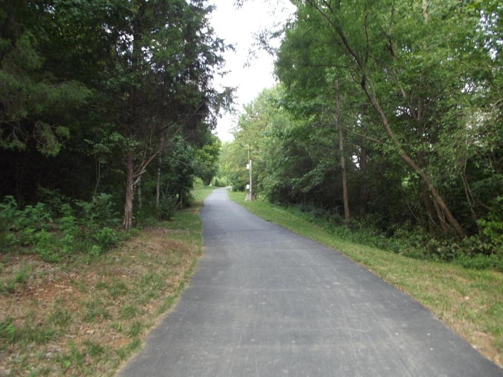
2 What is a Greenway? Active Transportation Linear Public Park Recreation Health and Fitness Desirable Amenity Access to destinations Creates a Sense of Community County standard is a 10 wide asphalt trail concforming to AASHTO and ADA for recreational trails. 37 miles are complete and open Mecklenburg County Greenway Plan currently calls for 185 miles.

3 Greenway is funded by NCDOT (CMAQ Grant), a City of Charlotte Implementation Grant and a Carolina Thread Trail Implementation Grant. MCPR is deeply appreciative of the generosity of these partners.
4 Project History Toby Creek Greenway, Phase 1 across the UNC Charlotte was opened to the public in April Toby Creek Greenway is part of the 2008 Mecklenburg County Park and Recreation Master Plan adopted by the Board of County Commissioners. This project was approved by the citizens as part of the 2008 Park and Recreation Bond Referendum, however the economic conditions did not allow the project to proceed. In , partnerships developed and grants were approved allowing this section of Toby Creek Greenway to be funded through NCDOT, the City of Charlotte and the Carolina Thread Trail.
5 Process Newell South Neighborhood Improvement Plan Staff participated in workshop held for this process to be aware of neighborhood concerns regarding the greenway as well as plans for Newell South pedestrian improvements along Rockland Drive and Blue Rock Road, in particular. NIP Construction is anticipated in late Greenway Community Workshops Workshop #1 Monday February 11, Preliminary Design Address opportunities and concerns. Workshop #2 Monday April 8, Approximately 50% Design Address opportunities and concerns. Complete design, permit and bid project. Begin construction in spring/summer Anticipate 9-12 months to complete.


6 Existing Conditions View looking Northeast on Hwy Town Center Plaza Harris Boulevard Hwy 49 Chancellor Park Drive/Hwy 49 Intersection View looking Southwest on Hwy Chancellor Park Drive


7 Existing Conditions Chancellor Park Drive Box Culvert Chancellor Park Drive Box Culvert View looking South on Rockland Drive to West Rocky River Road Intersection Rockland Drive/West Rocky River Road Intersection


8 Existing Conditions Rockland Drive/West Rocky River Intersection Rockland Drive Box Culvert Steep Slopes/Brambles along Rockland Drive Steep Slopes/Brambles along Rockland Drive

9 Preliminary Trail Alignment Overall Project

10 Preliminary Trail Alignment North Section

11 Preliminary Trail Alignment South Section
12 OPPORTUNITIES This project will provide a main greenway trail that is a permanent part of the Mecklenburg County Greenway Program. This effort is a public-private funding partnership with NCDOT, the City of Charlotte and the Carolina Thread Trail. Toby Creek Greenway will provide a direct link between Autumnwood and Clark s Mallard Creek Greenways, connecting local residential areas to a 9 mile and growing system of existing greenway trails, the largest in the County. The new greenway will provide access to existing Mallard and Clark s Creek Greenway, UNC Charlotte, schools, sports amenities and extensive dining and retail areas.
13 CONSTRAINTS Cost associated with the challenging topography will may require reconsidering some retail connections. CDOT will need to be directly involved in the at-grade crossing at West Rocky River Road. The underpass at Chancellor Drive will be challenging. The side trail along Hwy 49 will be challenging. There is a deadline that must be monitored concerning the beginning and completing construction by the funders.


14 Topography can be Challenging McAlpine Creek Greenway at Torrington Elevated Concrete Decking/Bridge Four Mile Creek Greenway in Matthews Segmental Unit Retaining Walls Four Mile Creek Greenway Wood Boardwalk
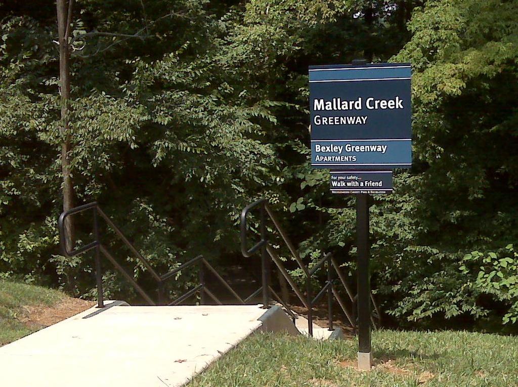
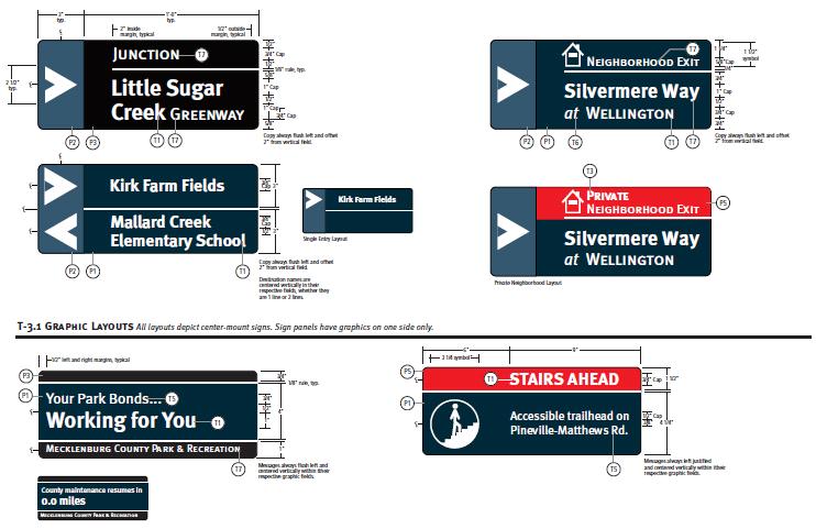
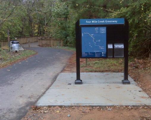
15 Wayfinding

16 Thank you for participating in your Community Workshop
17 Gwen Cook, RLA Planner Mecklenburg County Park and Recreation 5841 Brookshire Boulevard Charlotte, NC Phone: Karen Weston-Chien, RLA Project Manager Mecklenburg County Asset and Facility Management Business Support Services Agency 3205 Freedom Drive, Suite 101 Charlotte, NC Phone:
Welcome to the Information Session for Little Sugar Creek Greenway, Tyvola Road through Huntingtowne Farms Park
 Welcome to the Information Session for Little Sugar Creek Greenway, Tyvola Road through Huntingtowne Farms Park What is a Greenway? Active Transportation Linear Public Park Recreation Health and Fitness
Welcome to the first Community Workshop for Wesley Heights Greenway Cedar Street to Bruns Avenue
 Welcome to the first Community Workshop for Wesley Heights Greenway Cedar Street to Bruns Avenue What is a Greenway? Active Transportation Linear Public Park Recreation Health and Fitness Desirable Amenity
UNIVERSITY CITY AREA PLAN. Volume Two: Implementation Plan
 UNIVERSITY CITY AREA PLAN Volume Two: Implementation Plan Transforming the University City MSD into the vibrant, people-oriented place envisioned in the University City Plan will occur incrementally through
University City Area Plan
 University City Area Plan Economic Development & Planning Committee June 6, 2007 Purpose of the Meeting Provide an overview of the plan Set a date for public comment with City Council Mallard Creek Church
Yadkin River Greenway Feasibility Study Fact Sheet Village of Clemmons, Town of Lewisville, Town of Bermuda Run
 Fact Sheet Village of Clemmons, Town of Lewisville, Town of Bermuda Run Project Background The Yadkin River Greenway Feasibility Study is a joint project with the Village of Clemmons, the Town of Bermuda
PLANNING STAFF REVIEW
 Rezoning Petition 2016-087 Pre-Hearing Staff Analysis October 17, 2016 REQUEST Current Zoning: R-3 (single family residential), O-1(CD) (office, conditional), and INST (institutional) Proposed Zoning:
Potential Green Infrastructure Strategies May 6, 2015 Workshop
 Potential Green Infrastructure Strategies May 6, 2015 Workshop Background The City of Cortland is developing the Tioughnioga Urban Headwaters Green Infrastructure Action Plan with funding from the National
DRAFT SCOPE OF SERVICES PEER REVIEW OF BAKER PARK. Request for Qualifications (RFQ)
") DRAFT SCOPE OF SERVICES PEER REVIEW OF BAKER PARK Request for Qualifications (RFQ) The following scope of services is presented for consideration and development of firm qualifications submittal. Some
DRAFT SCOPE OF SERVICES PEER REVIEW OF BAKER PARK Request for Qualifications (RFQ) The following scope of services is presented for consideration and development of firm qualifications submittal. Some
North Carolina Department of Transportation Project Development and Environmental Analysis Branch
 North Carolina Department of Transportation Project Development and Environmental Analysis Branch Citizens Informational Workshop I-85, from I-485 to NC 73 Mecklenburg and Cabarrus Counties October 30,
What. - Civic anchors including a park and an updated library branch
 SUMMARY What Master Plan aimed at delivering - A walkable, mixed-use downtown in the heart of University City anchored by UNC Charlotte and University Research Park - Civic anchors including a park and
OVERMOUNTAIN VICTORY TRAIL BURKE CALDELL CORRIDOR FEASIBLITY STUDY REQUEST FOR QUALIFICATIONS CALDWELL COUNTY PATHWAYS
 OVERMOUNTAIN VICTORY TRAIL BURKE CALDELL CORRIDOR FEASIBLITY STUDY REQUEST FOR QUALIFICATIONS CALDWELL COUNTY PATHWAYS Caldwell County Pathways along with our co-partners City of Lenoir, Town of Gamewell,
Asbury Chapel Subdivision Sketch Plan
 Asbury Chapel Subdivision Sketch Plan PART 1: PROJECT SUMMARY Applicant: NVR Inc. Project Size: +/- 76.13 acres Parcel Numbers: 02101112,02116101,02116112, 02116113 Current Zoning: Transitional Residential
Gold Line Bus Rapid Transit Transit Oriented Development (BRTOD) Helmo Station Area Plan
 Helmo Station Area Plan") Appendix F Gold Line Bus Rapid Transit Transit Oriented Development (BRTOD) Helmo Station Area Plan Introduction and Purpose of the Plan The Gold Line Bus Rapid Transit facility is an eleven-mile dedicated
Appendix F Gold Line Bus Rapid Transit Transit Oriented Development (BRTOD) Helmo Station Area Plan Introduction and Purpose of the Plan The Gold Line Bus Rapid Transit facility is an eleven-mile dedicated
UPDATE ON THE INDEPENDENCE BOULEVARD AREA PLAN. Citizen Advisory Group Meeting March 3, 2011
 UPDATE ON THE INDEPENDENCE BOULEVARD AREA PLAN Citizen Advisory Group Meeting March 3, 2011 Purpose: Why are we here? To provide an update on the Independence Boulevard Area Plan 1. Overview of the ULI
Sherri Ferguson. President/CEO Portland Chamber of Commerce. Tennessee Certified Economic Developer Capstone Project
 Sherri Ferguson President/CEO Portland Chamber of Commerce Tennessee Certified Economic Developer Capstone Project Strategic Plan Development for the North Gateway of Portland, Tennessee The New Gateway
North Shore Trail. Council Meeting June 10, 2002
 North Shore Trail Council Meeting June 10, 2002 Process Guiding Principles Inventory and Analysis Preliminary Concepts (4) Final Concept Phasing Strategy Estimated Costs OVERVIEW Purpose: Prepare an overall
Planning Committee Agenda Packet
 Planning Committee Agenda Packet June 16, 2015 Room 280 5:00 p.m. Charlotte-Mecklenburg Planning Commission Planning Committee Meeting Agenda June 16, 2015 5:00 p.m. CMGC 2 nd Floor, Room 280 1. Call
Northwest Rail Corridor and US 36 BRT Development Oriented Transit Analysis 4.4 STATION AREA FINDINGS
 4.4 STATION AREA FINDINGS Each station is different, and each one requires a separate set of recommendations based on the vision for the site. This section outlines an initial TOD strategy and recommendations
A 30-mile Active Transportation Corridor. Technical Report. Prepared For: Prepared By:
 A 30-mile Active Transportation Corridor Technical Report Prepared For: Prepared By: August 2013 Acknowledgements The Jurisdictions of Mooresville, Davidson, Cornelius, Huntersville, Charlotte; and Iredell
Carolina Tread Trail Corridor Feasibility Study
 DRAFT Town of Mooresville Carolina Tread Trail Corridor Feasibility Study July 2012 table of contents 5 acknowledgements 7 summary of process 9 community involvement 10 alternative alignment analysis
Carrboro Greenways Commission January 9 th, 2007
 Carrboro Greenways Commission January 9 th, 2007 Statewide The flooding of Crabtree Valley in the early 1970 s (right before Crabtree Valley Mall was set to open) caused city, state, and federal officials
CRTPO Bicycle & Pedestrian Project Costs Panel Discussion
 CRTPO Bicycle & Pedestrian Project Costs Panel Discussion Introductions & Purpose By. Curtis Bridges CRTPO: Bicycle & Pedestrian Work Group CRTPO Bicycle & Pedestrian Project Costs CRTPO Funding Sources
Introduction. Midtown Loop. This project s purpose is to envision and design an urban greenway known as Midtown Loop for the Detroit Midtown area.
 Introduction This project s purpose is to envision and design an urban greenway known as for the Detroit Midtown area. Midtown includes the region s cultural core, historic and new neighborhoods, Wayne
W&OD PARK MASTER PLAN. The City s Greenest Street. DRAFT W&OD Trail Master Plan v4.docx Page 1
 W&OD PARK MASTER PLAN Adopted XXX-XX-XXXX The City s Greenest Street DRAFT W&OD Trail Master Plan v4.docx Page 1 Introduction and Purpose The Washington & Old Dominion Railroad Regional Park (W&OD) (which
Status Report for Parks and Recreation Capital Projects
 Attachment #2 Town of Chapel Hill Status Report for Parks and Recreation Capital Projects Prepared by Bill Webster, Assistant Director Chapel Hill Parks & Recreation Department March 19, 2009 1. Athletic
February 27, 2018 City Council Presentation The Crown Jewel Park in the City of Fairfax
 February 27, 2018 City Council Presentation The Crown Jewel Park in the City of Fairfax Master Planning Charge Van Dyck Park s first Master Plan will provide the City with a road map as to how best incorporate
Master Plan Workshop October 25, 2007 Charlotte Mecklenburg Government Center
 Master Plan Workshop October 25, 2007 Charlotte Mecklenburg Government Center Land Discussion 1. What are the most important land related issues we need to address? Protect natural areas Passive walking
PLANNING COORDINATING COMMITTEE
 PLANNING COORDINATING COMMITTEE Fall Meeting/Luncheon Welcome! October 16, 2009 PLANNING COORDINATING COMMITTEE Fall Meeting/Luncheon WELCOME! WELCOME! October 16, 2009 October 16, 2009 Agenda I. Lunch/Socialize
Rich Valley Greenway Master Plan. Central Greenway Connectivity Study
 Rich Valley Greenway Master Plan Central Greenway Connectivity Study Dakota County Planning Commission February, 2017 Rich Valley Greenway Master Plan Dakota County Greenway Vision Establish a County-wide
CITY OF BEACON NOTICE TO LANDSCAPE ARCHITECTS GENERAL INFORMATION AND REQUEST FOR PROPOSALS
 CITY OF BEACON NOTICE TO LANDSCAPE ARCHITECTS GENERAL INFORMATION AND REQUEST FOR PROPOSALS The City of Beacon (the CITY) is issuing this Request for Proposals (RFP) for the selection of a landscape architect
Small Area Plan. South Gateway
 Small Area Plan Adopted May 12, 2008 South Gateway Purpose. The South Gateway Small Area Plan defines the City s expectations for the future of the southern entrance to the City at Interstate 85 and Highway
Town of Cornelius Bond Update August, 2017
 Town of Cornelius Bond Update August, 2017 Referendum Results Roads, Intersections, & Sidewalks ($11.15 mil) Pass rate 81.38% in favor Parks and Recreation ($5.25 mil) Pass rate 72.09% in favor Town Center
MILLS PARK & PANTHER CREEK GREENWAY
 , North Carolina August 19th, 2014 Introduction, North Carolina Why are we here? Planning Investment to Date - Park, North Carolina 2012 Parks, Recreation, and Cultural Resources Master Plan Planning Investment
Beatties Ford Road & Mt. Holly-Huntersville Road Small Area Plan
 Beatties Ford Road & Mt. Holly-Huntersville Road Small Area Plan Town of Huntersville October 2005 Town of Huntersville Planning Department 101 Huntersville Concord Road Post Office Box 664 Huntersville,
Pennsy Greenway Trail
 Town of Schererville Pennsy Greenway Trail DES. #s: 0401062, 1173595 & 1382661 Construction of Pennsy Greenway Trail beginning at Wilhelm Street and continuing northwest along the former Penn Central railroad
Technical Team Meeting MEETING SUMMARY
 Technical Team Meeting MEETING SUMMARY Monday, January 14, 2019, 3:00 PM Town Hall Room 3211 Technical Team Attendees: Jason Burdette, Town of Davidson Rich Hoffman, Iredell County Matthew Todd, Iredell
TIRZ 17/Redevelopment Authority Capital Improvements Plan Projects
 Gessner Widening: T-1701 What: Widen the road from a six-lane divided boulevard to an eight-lane divided boulevard street section, increase turn lanes, update traffic signal system, improve drainage by
1. Parks & Recreation Neighborhood Parks Community Parks Special Use Sites 2. Open Space 3. Trails
 Appendix A: Park Classifications The intent of parks and recreation classifications is to aid in making acquisition and design decisions for park sites, facilities and the organization of recreation space
Errol Heights Park and Community Garden Frequently Asked Questions March 22, 2018
 Errol Heights Park and Community Garden Frequently Asked Questions March 22, 2018 Question 1: What improvements are planned for Errol Heights Park? How will the community be engaged in the process to shape
City of Poughkeepsie Waterfront Redevelopment Strategy. Poughkeepsie Waterfront Redevelopment Strategy
 City of Poughkeepsie Waterfront Redevelopment Strategy Poughkeepsie Waterfront Redevelopment Strategy City of Poughkeepsie Prime Assets: Major Waterfront Advantages: - Central City of the Hudson River
DRAFT PLAN PRESENTATION
 DRAFT PLAN PRESENTATION 1.23.2018 AGENDA Process Project Schedule Results from Visioning Workshop Draft Plan Highlights Concept Plans Feedback Next Steps PROJECT SCHEDULE KICK-OFF WORKSHOP August 29 th
Montana Rail Link Park
 Montana Rail Link Park Neighborhood Open House A Missoula Community Partnership WITH LEADERSHIP FROM THE FRANKLIN TO THE FORT & SOUTHGATE TRIANGLE NEIGHBORHOODS Sovereign Hope Church, (1919 North Ave.)
Mendota-Lebanon Hills Greenway Master Plan Executive Summary. August draft for more information visit
 Mendota-Lebanon Hills Greenway Master Plan Executive Summary August 2013 draft for more information visit www.hkgi.com/projects/dakota INTRODUCTION The Mendota-Lebanon Hills Greenway Master Plan portrays
M E M O R A N D U M. DATE: July 19, Patrick D. O Keeffe, City Manager. Economic Development & Housing
 M E M O R A N D U M DATE: July 19, 2011 TO: FROM: Patrick D. O Keeffe, City Manager Economic Development & Housing SUBJECT: Resolution of the City Council of the City of Emeryville Approving the Application
Secrest Short Cut and Monroe Expressway Small Area Plan AUGUST 29, 2018
 Secrest Short Cut and Monroe Expressway Small Area Plan AUGUST 29, 2018 Background and Process Monroe Expressway will be open by the end of 2018 Union County and Indian Trail identified a need to revisit
The petition proposes to rezone the site to allow all uses permitted in the B-1 (neighborhood business) district.
 district.") Rezoning Petition 2018-040 Pre-Hearing Staff Analysis June 18, 2018 REQUEST Current Zoning: R-17MF (multi-family residential) Proposed Zoning: B-1 (neighborhood business) LOCATION Approximately 0.38 acres
Rezoning Petition 2018-040 Pre-Hearing Staff Analysis June 18, 2018 REQUEST Current Zoning: R-17MF (multi-family residential) Proposed Zoning: B-1 (neighborhood business) LOCATION Approximately 0.38 acres
Metropolitan Parks and Open Space Commission
 Business Item No. 2013-xxx Metropolitan Parks and Open Space Commission Meeting date: October 1, 2013 For the Community Development Committee meeting of October 7, 2013 Subject: Mendota-Lebanon Hills Greenway
STP DA Candidate Pedestrian Projects Funding Recommendations
 STP DA Candidate Pedestrian Projects Funding Recommendations Rank Municipality Project Description Total Cost STP DA Local Notes Cumulative STP DA Funding Request Date 1 Winston Martin Luther King Jr.
V. Gateways GATEWAYS / V-1
 V. GATEWAYS / V-1 Many of Chesapeake s gateways are located on highways and call for bold and attractive designs that motorists can understand, appreciate, and enjoy. can also take the form of natural
Downtown Dubuque...it s a great time.
 Downtown Dubuque...it s a great time. Your timing could not be better to invest in Downtown. With hundreds of millions in public and private investment occurring on the City s downtown waterfront, millions
DRAW SEVEN PARK RENOVATION PROJECT SOMERVILLE, MASSACHUSETTS
 DRAW SEVEN PARK RENOVATION PROJECT SOMERVILLE, MASSACHUSETTS DCR Public Meeting Monday, February 5th 6:30pm-8:30pm East Somerville Community School 50 Cross Street, Somerville, MA, 02145 Commonwealth of
City of Iowa City Department of Neighborhood and Development Services Department of Parks and Recreation Department of Public Works City Manager s
 RFP Pre-submittal meeting December 18, 2015 City of Iowa City Department of Neighborhood and Development Services Department of Parks and Recreation Department of Public Works City Manager s Office Background
PRELIMINARY PLAT DESIGN REQUIREMENTS Updated 4/8/2016
 PRELIMINARY PLAT DESIGN REQUIREMENTS Updated 4/8/2016 The following items are required for the preliminary plat. Numbers correspond with those on the example preliminary plat. RENO COUNTY SUBDIVISION REQUIREMENTS
Overview of the Plan. The Building Blocks of Centers, Neighborhoods and Network INTERNAL DRAFT
 Overview of the Plan 4 East Davidson Ramah Church Rd June Washam Rd Bradford District Park Bradford Shearer Rd Campus District NC 73 Davidson-Concord North Rocky River This Master Plan projects an approximate
BROOKHILL NEIGHBORHOOD MODEL ZONING MAP AMENDMENT PREFACE TO APPLICATION
 BROOKHILL NEIGHBORHOOD MODEL ZONING MAP AMENDMENT PREFACE TO APPLICATION June 15, 2015 Revised: August 1, 2016 I. VISION Brookhill is a proposed community based upon the principles of Albemarle County
Welcome to the LYNX Blue Line Extension Transit Station Area Plans Public Workshop No. 3. Presentation will begin at 6:00 P.M.
 Welcome to the LYNX Blue Line Extension Transit Station Area Plans Public Workshop No. 3 Presentation will begin at 6:00 P.M. Meeting Agenda Blue Line Extension (BLE) Project Update LYNX Blue Line Extension
Little Neck Planning Area
 Little Neck Planning Area Current Reality The Little Neck Planning Area is characterized by established residential neighborhoods, Town Center and Pembroke. The Eastern and Western Branches of the Lynnhaven
Mecklenburg County Park and Recreation 2008 Bond Referendum - November 4, 2008 $250 Million
 Mecklenburg County Park and Recreation 2008 Bond Referendum - November 4, 2008 $250 Million Conservation and Stewardship Greenways Parks Recreation and Aquatic Facilities Athletics Mecklenburg County Park
Public Meeting Final Recommendations August 8, 2013
 Public Meeting Final Recommendations August 8, 2013 Meeting Agenda 1. Existing Conditions 2. Plan Building Blocks & Process 3. The Plan Policies 4. What we heard 5. Next Steps Existing Conditions Existing
MAYFIELD VILLAGE GREENWAY TRAIL
 1 Shared use 10 wide asphalt all purpose trail Includes 60 ft. steel truss bridge, 549 ft. of boardwalk, three underpasses Connects Village center to Library, Metroparks, and Village recreational areas
PARKS AND RECREATION
 PARKS AND RECREATION WHAT YOU WILL FIND IN THIS CHAPTER: Background information on the development of the Park, Recreation, and System Plan (PRSP). General overview of Ellensburg s parks and recreation
Rezoning Petition Pre-Hearing Staff Analysis May 21, 2018
 Rezoning Petition 2018-028 Pre-Hearing Staff Analysis May 21, 2018 REQUEST Current Zoning: MX-1 LLWPA (mixed use district, Lower Lake Wylie Protected Area), R-3 LLWPA (single family residential, Lower
5.0 WAYFINDING STREETSCAPE DESIGN MASTER PLAN 55
 OVERVIEW 57 SIGN TYPE A: GATEWAY 57 SIGN TYPES B & C: WAYFINDING KIOSKS & BOLLARDS 58 SIGN TYPES D: POLE MOUNTED ELEMENTS 59 SIGN TYPE E: LARGE-SCALE TYPOGRAPHIC INSTALLATION 60 SIGN TYPE F: VERTICAL CHOPSTICKS
Chapter 5: Natural Resources and Environment
 NATURAL RESOURCES AND ENVIRONMENT 5-1 5 Chapter 5: Natural Resources and Environment BACKGROUND AND INTENT Urban expansion represents the greatest risk for the future degradation of existing natural areas,
METROPOLITAN COUNCIL 390 North Robert Street, St. Paul, MN Phone (651) ; TDD (651)
 ; TDD (651)") DATE: December 20, 2011 METROPOLITAN COUNCIL 390 North Robert Street, St. Paul, MN 55101 Phone (651) 602-1000; TDD (651) 291-0904 TO: Metropolitan Parks and Open Space Commission FROM: Tori Dupre, Senior
DATE: December 20, 2011 METROPOLITAN COUNCIL 390 North Robert Street, St. Paul, MN 55101 Phone (651) 602-1000; TDD (651) 291-0904 TO: Metropolitan Parks and Open Space Commission FROM: Tori Dupre, Senior
GREENWAY MASTER PLAN. Little Sugar Creek. Executive Summary
 GREENWAY MASTER PLAN Little Sugar Creek Executive Summary Mecklenburg County Park and and Recreation Department 5841 Brookshire Boulevard Charlotte, North Carolina 28216 704.336.3854 www.parkandrec.com
ROUND ONE PROJECTS. Capital Grants 18 DELAWARE VALLEY REGIONAL PLANNING COMMISSION
 ROUND ONE PROJECTS DVRPC awarded the first round Take Me to the River grants in 2008 (see Figure 5 for project locations). The 13 projects selected were chosen based on their ability to reconnect citizens
Rezoning Petition Final Staff Analysis June 18, 2018
 Rezoning Petition 2018-028 Final Staff Analysis June 18, 2018 REQUEST Current Zoning: MX-1 LLWPA (mixed use district, Lower Lake Wylie Protected Area), R-3 LLWPA (single family residential, Lower Lake
Description of Preferred Alternative
 Chapter 2 Description of Preferred Alternative 2.1 Introduction This chapter of the programmatic Sammamish Town Center Sub-area Plan Final EIS provides a more detailed description of the Preferred Alternative
Appendix I. Appendix I - CURRENT CONDITIONS & CONCEPTS. Appendix I - CURRENT CONDITIONS & CONCEPTS
 Appendix I - CURRENT CONDITIONS & CONCEPTS Appendix I - CURRENT CONDITIONS & CONCEPTS Appendix I Existing Regional Study Boundary and Zoning Susceptible To Change Existing Condition and Approved Plans
BENJAMIN BANNEKER PARK FRAMEWORK PLAN (PLAN ADOPTION)
") BENJAMIN BANNEKER PARK FRAMEWORK PLAN (PLAN ADOPTION) COUNTY BOARD MEETING DECEMBER 16, 2017 County Board Consideration: Adopt the Benjamin Banneker Park Framework Plan and Design Guidelines Framework
BENJAMIN BANNEKER PARK FRAMEWORK PLAN (PLAN ADOPTION) COUNTY BOARD MEETING DECEMBER 16, 2017 County Board Consideration: Adopt the Benjamin Banneker Park Framework Plan and Design Guidelines Framework
Stakeholders Advisory Working Groups (SAWGs) Smart Growth and TOD Land Use (#11) SAWG Meeting
 Smart Growth and TOD Land Use (#11) SAWG Meeting") Presentation - Part II Tappan Zee Bridge/I-287 Corridor Project July 21, 2010 Slide 1. David Kooris (Regional Plan Association) welcomed members of the Land Use Stakeholders Advisory Working Groups (SAWGs)
Presentation - Part II Tappan Zee Bridge/I-287 Corridor Project July 21, 2010 Slide 1. David Kooris (Regional Plan Association) welcomed members of the Land Use Stakeholders Advisory Working Groups (SAWGs)
Nine Mile Creek Regional Trail Update. Edina City Council Workshop March 4, 2014
 Nine Mile Creek Regional Trail Update Edina City Council Workshop March 4, 2014 Presentation Outline: Where we ve been - Recap of route assessment process and approved route Where we are now - Summary
NEIGHBORHOOD DESIGN ELEMENT
 NEIGHBORHOOD DESIGN ELEMENT INTRODUCTION The following recommendations constitute an urban design oriented "neighborhood analysis" of Plantation. It is an optional Comprehensive Plan Element. The five
2035 General Plan Update and Belmont Village Specific Plan. Joint Study Session with the City Council and Planning Commission April 12, 2016
 2035 General Plan Update and Belmont Village Specific Plan Joint Study with the City Council and Planning Commission April 12, 2016 Agenda 1. Welcome and Introductions 2. General Plan Update Status of
ARTICLE 13 STREETS General
 ARTICLE 13 STREETS 13.1 General Streets shall be designed to suit their functions. Many streets have purposes other than vehicular traffic. As an alternative to current N.C. Department of Transportation
Commercial Node Plan Devine Street/Jackson Blvd. COLUMBIA, SC
 Commercial Node Plan Devine Street/Jackson Blvd. COLUMBIA, SC 9.17.13 AGENDA 1 Introductions 2 Project Update 3 Concepts 4 Recommendations 5 Next Steps Introductions Project Update Process 5-Phase Process
ARTICLE 13 STREETS General
 ARTICLE 13 STREETS 13.1 General Streets shall be designed to suit their functions. Many streets have purposes other than vehicular traffic. As an alternative to current N.C. Department of Transportation
Special Revenue Funds
 Special Revenue Funds Special Revenue Funds account for the proceeds of specific revenue sources (other than special assessments for major capital projects) that are legally restricted to expenditures
NORTH CLAYMONT AREA MASTER PLAN COMMUNITY WORKSHOP #1 FEBRUARY 3, 2016
 NORTH CLAYMONT AREA MASTER PLAN COMMUNITY WORKSHOP #1 FEBRUARY 3, 2016 1. Introduction To the team and to the Plan Planning Partners The Claymont Community WILMAPCO New Castle County Claymont Renaissance
CITY OF GAINESVILLE PARKS, RECREATION AND CULTURAL AFFAIRS DEPARTMENT VISION 2020
 CITY OF GAINESVILLE PARKS, RECREATION AND CULTURAL AFFAIRS DEPARTMENT VISION 2020 A BLUE PRINT FOR THE NEXT 20 YEARS The PRCA Vision 2020 Master Plan, adopted in November 2012, addresses the current state
UNCW CAMPUS MASTER PLAN
 UNCW CAMPUS MASTER PLAN JULY 27, 2017 MASTER PLAN FRAMEWORK RECOMMENDATIONS BOARD OF TRUSTEES PRESENTATION UNCW Campus Master Plan Update Board of Trustees Presentation July 27, 2017 The attached Campus
DOWNTOWN NORFOLK COUNCIL ACTION PLAN. Strategic Initiatives Focus Area Objectives. Departmental Focus Area Key Objectives
 DOWNTOWN NORFOLK COUNCIL ACTION PLAN FY18 Strategic Initiatives Focus Area Objectives Departmental Focus Area Key Objectives STRATEGIC INITIATIVES FOCUS AREA OBJECTIVE #1: NURTURE A VIBRANT URBAN ENVIRONMENT
DOMINION BOULEVARD CORRIDOR STUDY AND ECONOMIC DEVELOPMENT STRATEGIC PLAN A MODEL FOR CHESAPEAKE S FUTURE
 DOMINION BOULEVARD CORRIDOR STUDY AND ECONOMIC DEVELOPMENT STRATEGIC PLAN A MODEL FOR CHESAPEAKE S FUTURE Overview I. Draft Plan Process II. Draft Plan Overview a. Market Analysis b. Master Land Use Plan
Welcome. Northern Segment of Hwy 100 I-90 to South of Madison Street Meeting Goals:
 Welcome Northern Segment of Hwy 100 I-90 to South of Madison Street Meeting Goals: - Review Environmental Assessment - Share Preferred Alternative -Receive Public Comments 2003 EA Preferred Alternative
LITTLE ELM CAPTIAL IMPROVEMENT BOND STREET PRESENTATION
 LITTLE ELM 2009-2014 CAPTIAL IMPROVEMENT BOND STREET PRESENTATION Denton Frisco Little Elm Lewisville Legacy Southlake Grapevine Addison DENTON COUNTY & LEWISVILLE LAKE MATCHING FUNDS DENTON COUNTY BOND
Atlanta BeltLine Subarea 3 Master Plan Update
 Atlanta BeltLine Subarea 3 Master Plan Update April 14, 2018 Workshop Meeting 1 22 miles, connecting 45 neighborhoods 22 MILES of transit 46 MILES of streetscapes and complete streets 33 MILES of urban
Northeast Quadrant Plan
 Northeast Quadrant Plan Northeast Quadrant Distinctive Features Land Use The Northeast Quadrant includes all the area within the planning area that is east of Interstate 5 and to the north of State Route
2017 General Obligation Bond
 2017 General Obligation Bond Presentation of Public and Council Projects to the Transportation & Mobility Stakeholder Committee April 13, 2017 Agenda Deferred Maintenance Project Development Process Projects
Town of Portola Valley General Plan. Nathhorst Triangle Area Plan
 Town of Portola Valley General Plan Amended December 10, 1997 Table of Contents Introduction... 1 Planning Area... 1 Objectives... 2 Principles... 2 Standards... 4 Description... 4 Community Commercial...
Meeting Purpose & Agenda
 Meeting Purpose & Agenda Meeting Purpose: To provide a summary of the results of the Downtown Parks Site Assessment and Feasibility Study By recommendation, provide direction to staff on which City-owned
Rezoning Petition Pre-Hearing Staff Analysis September 17, 2018
 Rezoning Petition 2018-065 Pre-Hearing Staff Analysis September 17, 2018 REQUEST Current Zoning: NS (neighborhood services) Proposed Zoning: NS SPA (neighborhood services, site plan amendment) with five-year
Business Item No
 Community Development Committee For the Community Development Committee meeting of December 19, 2016 For the Metropolitan Council meeting of January 11, 2017 Business Item No. 2016-255 Subject: River to
City of Plantation Midtown District Conceptual Plan Implementation Update. City Council Presentation February 22, 2017
 City of Plantation Midtown District Conceptual Plan Implementation Update City Council Presentation February 22, 2017 Purpose of Presentation The purpose of this presentation is to: 1. Review key concepts
preliminary master plan Cover Slide executive summary public presentation
 preliminary master plan public presentation executive summary Cover Slide {agenda} + Master Plan Process + Context and Overviews + Preliminary Concepts - Entry/Gateways - Core District - Streetscape +
Saranac River Trail Greenway C O N D I T I O N S R E P O R T
 Saranac River Trail Greenway C O N D I T I O N S R E P O R T City of Plattsburgh Clinton County, NY For: Clinton County Final Issued: March 22, 2017 This document was prepared for the New York State Department
Oconee Rivers Greenway Project. TSPLOST 2018 Project # 5 Project Concept Sub-projects 7, 8, 9, 10, & 11. Mayor & Commission Work Session
 Oconee Rivers Greenway Project Project # 5 Project Concept Sub-projects 7, 8, 9, 10, & 11 Mayor & Commission Work Session February 13, 2018 North Oconee River Greenway 1 Project # 05 - Oconee Rivers Greenway
An Ambitious Plan: Transforming the blighted South Platte River and surrounding environment into Denver s greatest natural resource.
 CONNECTING THE PEOPLE TO THEIR RIVER SOUTH PLATTE RIVER VISION IMPLEMENTATION PROGRAM: GRANT-FRONTIER PARK TO OVERLAND POND PARK REACH The South Platte River Vision Implementation Program (River Vision)
ROCKAWAY BOARDWALK Community Board 14 Parks Committee Meeting June 4, 2014
 ROCKAWAY BOARDWALK Community Board 14 Parks Committee Meeting June 4, 2014 Introduction 2 Agenda Design Update Construction Update Local Hiring Update 3 Community Input 7 Meeting Date September 17, 2013
DRAFT. 10% Common Open Space
 % OF CHARLOTTE IS CATEGORIZED AS A. LAND USES : Placeholder map displaying location of Place Type GOALS: Accommodate XX% of future growth. Provide a concentration of primarily commercial and civic activity