Task Force on Harbourfront Developments on Hong Kong Island
|
|
|
- Spencer Osborne
- 5 years ago
- Views:
Transcription
1 Task Force on Harbourfront Developments on Hong Kong Island For discussion on 10 May 2012 TFHK/04/2012 Proposed Composite Hotel, Residential and Public Open Space Development In Comprehensive Development Area at 12 Oil Street, North Point, Hong Kong PURPOSE This paper seeks Members views on the planning and design of the Proposed Composite Hotel, Residential and Public Open Space Development ( Proposed Development ) in terms of, inter alia, land use compatibility, urban design context, visual impact, the objective to create a healthy and attractive living environment, and the provision of an accessible harbourfront. BACKGROUND 2. The Proposed Development is located at the Ex-Government Supplies Depot Site at Oil Street, North Point ( Application Site /the Site ) (Figure 1 refers). The Site is zoned Comprehensive Development Area ( CDA ) on the Approved North Point Outline Zoning Plan No. S/H8/24 ( Approved OZP ). 3. The Application Site is located at a prime location at the waterfront with very good accessibility. It was previously occupied by the Government Supplies Department ( GSD ) as headquarters and storage depot. GSD has vacated from the Site since late 1990s and the Site has been left vacant or occupied by temporary uses since then. To the immediate south of the Site is the historic former Royal Hong Kong Yacht Club undergoing revitalisation works for the LCSD ArtSpace project. 4. The Applicant acquired the Site through a government tender in A S16 Planning Application was lodged on 30 December Subsequent to the receipt of comments from various Government Departments, the proposed scheme has been slightly revised. The
2 Task Force on Harbourfront Developments on Hong Kong Island TFHK/04/2012 Master Layout Plan ( MLP ), the corresponding Technical Schedule and the Landscape Master Plan are appended in Annex A and B respectively. 5. The Proposed Development comprises a total of not more than 400 dwelling units ranging from 40m 2 to over 160m 2 with a maximum of 40,200m 2 domestic gross floor area (GFA). In addition, ancillary facilities in the form of, for instance, residents clubhouse, recreational area and private open space are proposed for the future residents. 6. A Hotel with GFA of 30,000m 2 and approx. 800 guestrooms are also proposed within the Proposed Development in accordance with the requirement under the Government Lease Conditions. The Hotel, together with the other hotels in the near vicinity will help strengthening North Point as a secondary tourist district in accordance with the Metro Plan. DESIGN INTENT 7. Considering the prominent location at the waterfront, the Applicant has made reference to the relevant guidelines (e.g. Harbour Planning Guidelines, Town Planning Board s Vision Statement for Victoria Harbour, etc.) in the layout and design of the Proposed Development. 8. The architectural design was inspired by the characteristics of the Site magnificent Victoria Harbour view, the surrounding historic context as well as the visual linkage across the harbour. The façade design and building form of the Proposed Development has therefore incorporated the concept of Sail, a symbolic feature related to the Harbour and the historical background of the Former Clubhouse of Royal Hong Kong Yacht Club. DESIGN MERITS 9. The Proposed Development has adopted aesthetic building designs, enhancing natural ventilation and visual permeability for the Page 2
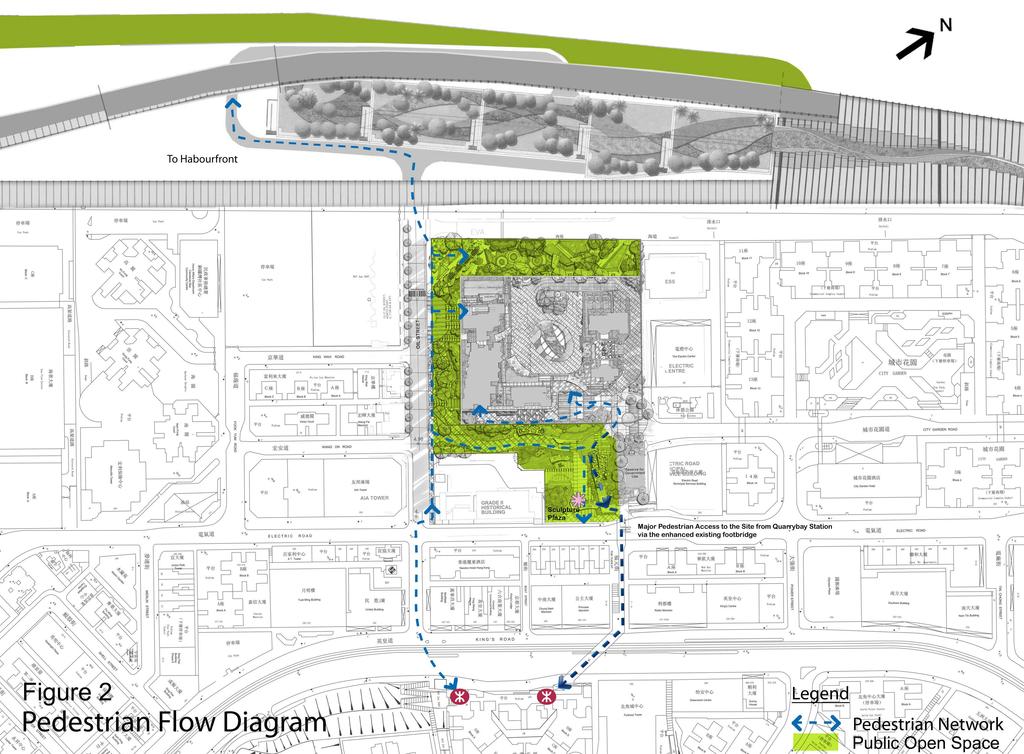
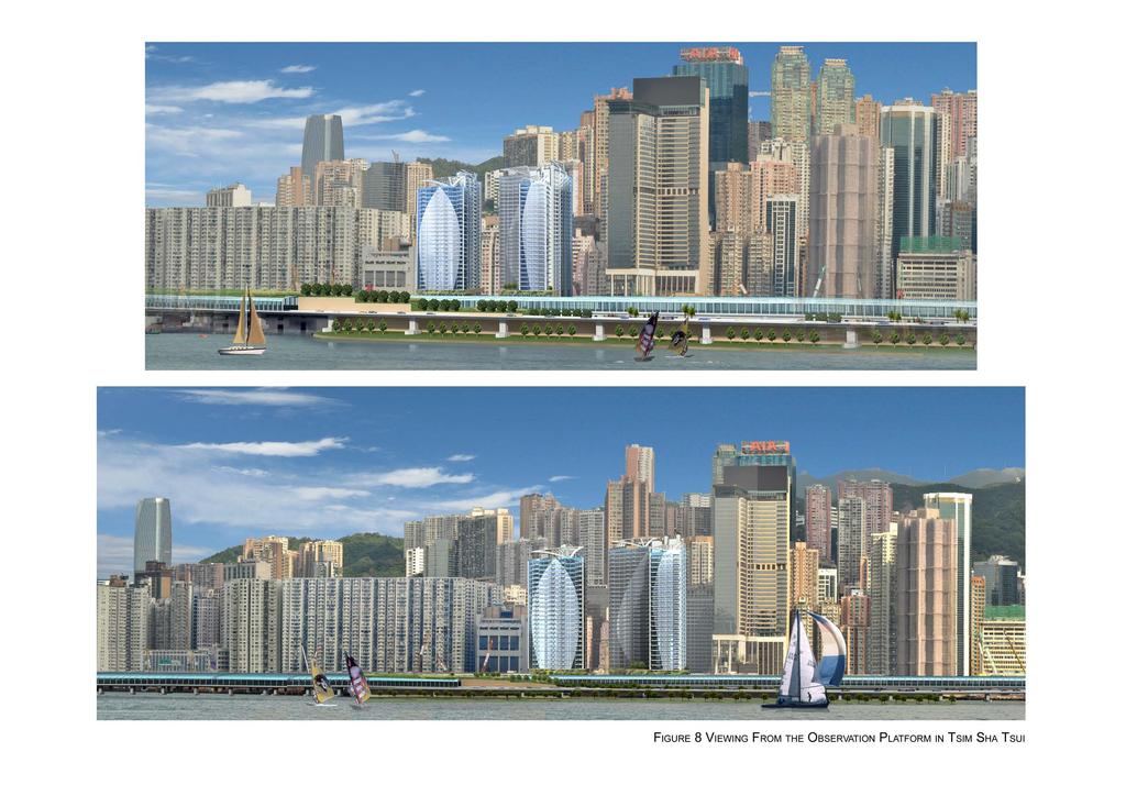
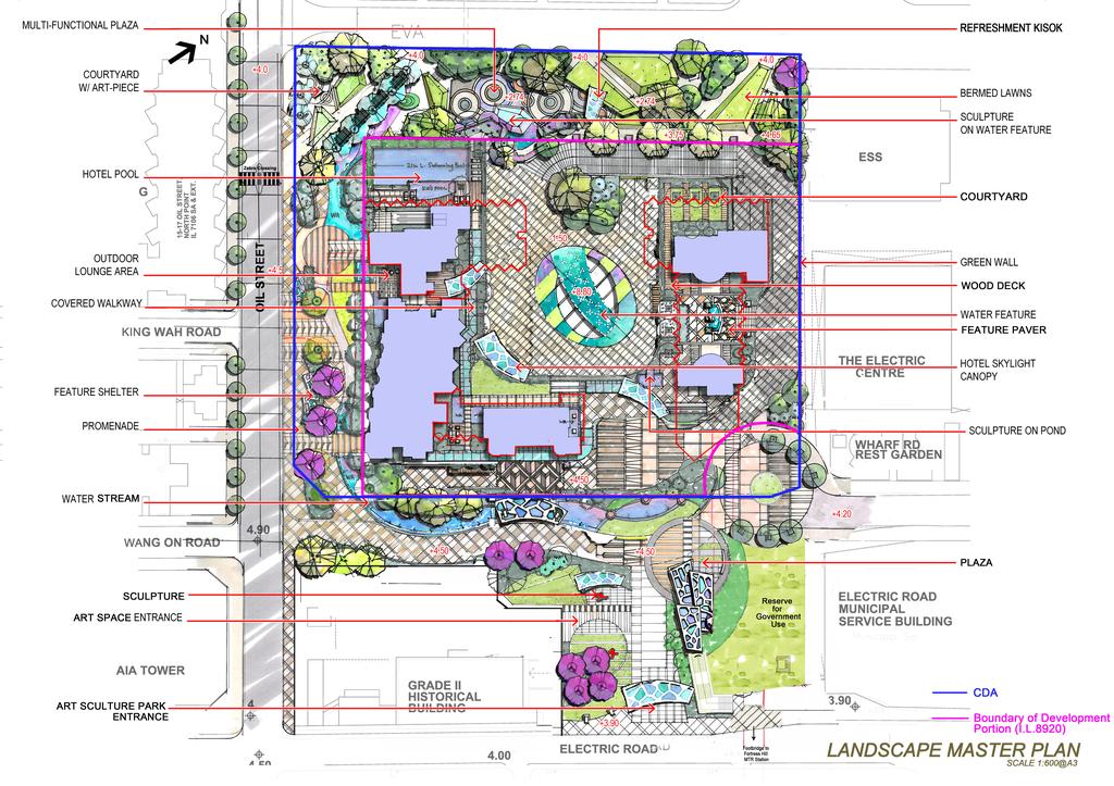
3 Task Force on Harbourfront Developments on Hong Kong Island TFHK/04/2012 benefit of both the future residents as well as populations in the wider North Point area. Due consideration has also been given to the characteristics of the adjacent areas and the Site s exposure to the Victoria Harbour in the aspects of both visual and physical relationship. The following sets out the design merits of the Proposed Development :- (a) (b) (c) Offering an Accessible and Enjoyable Public Open Space in Connection with the Future Waterfront Promenade The Proposed Development will include public open space on three sides at the northwest, southwest and southeast of the site. These three pieces of connected public open space will be constructed by the Applicant and then be handed over to the Government. It fronts along Oil Street, Electric Road and City Garden Road and the public will have right of access 24 hours/7 days a week. People can also easily access the open space via the elevated footbridge linking from the Fortress Hill Station (Figure 2 refers). The footbridge provides an elevated area as an observation platform to enjoy the picturesque image of Tsim Sha Tsui waterfront through the elegant central courtyard of the development. Down from the footbridge, there is a wide Sculpture Plaza surrounded by trees, shrubs and beautiful undulating lawn with exhibition of artpieces and sculptures which serves also an extension to the future ArtSpace at the adjacent historical building, the Former Yacht Club. People can then walk to the future waterfront promenade through the pathway at public open space along Oil Street. The public open space does not only offer the public a convenient access to and from the harbourfront, but also a relaxing and pleasant pathway accompanied by decent street furniture, water stream and greenery. At the end of the Public Open Space in the north-western boundary of the Site, there is a cul-de-sac where People can experience a completely different and interesting area. The changing levels in this area provide visual connection between the Public Open Space and the open space at the Page 3
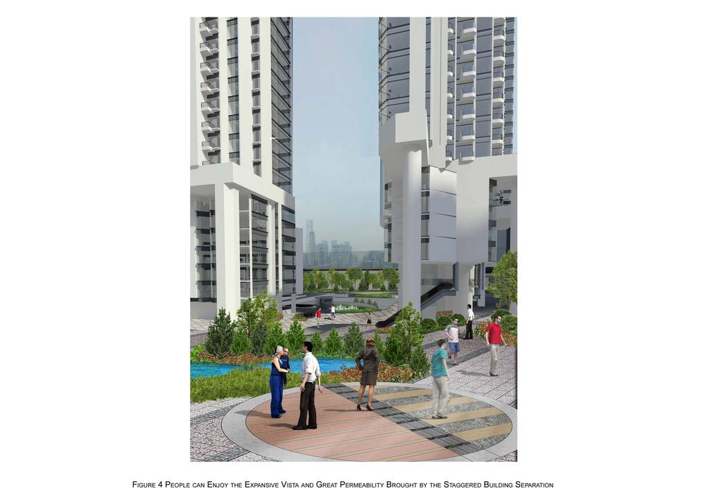
4 Task Force on Harbourfront Developments on Hong Kong Island TFHK/04/2012 central courtyard of the Proposed Development to give a sense of spaciousness. Meanwhile, some sail-like sculptures will be placed to symbolise the significant location at the waterfront and kiosks are proposed to provide more opportunities for diversity of uses and to enhance vibrancy at the harbourfront. (d) (e) (f) In addition, the Proposed Development allocates all car parking spaces underground instead of adopting the conventional practice to accommodate car park and commercial uses in a bulky podium structure with very high site coverage. Without a huge podium structure, street level greening, visual permeability and natural airflow through the Site will be maximised and the perception of the building bulk at street level will be reduced. The freed up ground floor space makes on-grade open space more easily accessible and enjoyable. More opportunities for plantings and street furniture can therefore be explored. This will help to deliver a pleasant and high-quality streetscape all along the path towards the future waterfront promenade. The integration of green open space, ArtSpace at the adjacent historic building as well as the waterfront promenade offer a lively Green Oasis as well as a Cultural and Leisure Hub in North Point. The magnificent views and the interesting experience at the public open spaces bring the people to the Harbour and the Harbour to the people 1. Providing Wide Building Separation and View/Air Corridors to enhance Permeability and Visual Connectivity The building mass of Proposed Development is broken down into two clusters with a wide separation in between as shown in Figure 3. This creates a wide gap of about 27m at ground level and over 40m at upper levels at the seaward side. Meanwhile, the two clusters are 20m apart 1 This is completely in line with Goal 1 of the Town Planning Board s goals for Victoria Harbour To bring people to the Harbour and the Harbour to the people Page 4
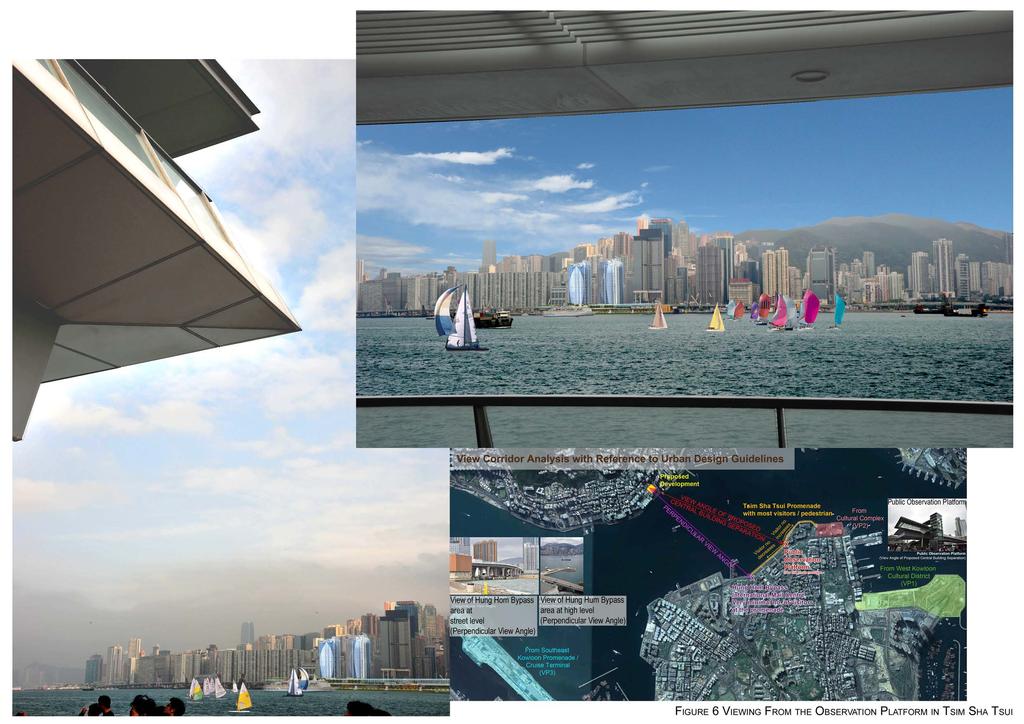
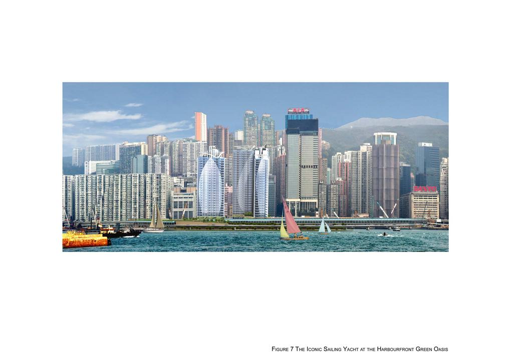
5 Task Force on Harbourfront Developments on Hong Kong Island TFHK/04/2012 at the landward side facing Electric Road. The staggered building separation will offer an expansive vista and hence better visual permeability towards the Victoria Harbour. This is going to benefit the future users of the Sculpture Plaza of the public open space which will become the gathering node with pedestrians entering from Electric Road, users of the footbridge connection and visitors of ArtSpace (Figure 4 refers). (g) (h) (i) Besides, an Air Ventilation Assessment had also been carried out which demonstrated that the Proposed Development would bring no adverse impact to the surroundings in terms of air ventilation. The view corridor created by the central building separation does not only provide visual permeability to and from the harbourfront, but also promotes the visual connection across the harbour between the Site and Tsim Sha Tsui Promenade (the major tourist spots in Hong Kong). The observation platform offered by the elevated footbridge of Proposed Development will echo with the Public Observation Platform at Tsim Sha Tsui East, from both of which people can enjoy panoramic views of the world-famous city skyline of Victoria Harbour (Figures 4-6 refer). Creating a Visually Interesting Harbour Image through Vivid Building Appearance of Sailing Yacht at Harbourfront with Diversity in Building Mass and Varying Building Heights The Proposed Development has been inspired by the scene of grand sailing tournament across the Victoria Harbour and the historic context of the former clubhouse of the Royal Hong Kong Yacht Club. Through the visual connection with Tsim Sha Tsui East, one of Hong Kong s most renowned tourist spots where tourists can enjoy the spectacular and impressive view of the beautiful Victoria Harbour with countless cruise vessels, junks, sampans and pleasure craft gliding around, the Proposed Page 5
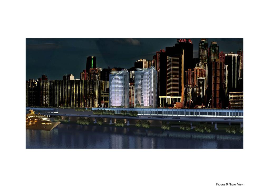
6 Task Force on Harbourfront Developments on Hong Kong Island TFHK/04/2012 Development has adopted an interesting symbolic design of the elevation echoing the sailing yacht with the sail feature at roof which will be visible from this prime tourist node (Figures 7-9 refer). (j) (k) On the other hand, the Development s distinct stepped building height profile with descending building height towards the harbourfront will avoid a monotonous harbourfront image. In this respect, the Architect has made reference to the neighbouring area when designing the building height for each individual tower. Given that the North Point Area is characterised by high-rise buildings, the building height of the Proposed Development is deemed appropriate and will not adversely affect the visual amenity of the surrounding environs. In addition to a 50m set back from the Island Eastern Corridor, the Proposed Development has adopted the design with a central courtyard which opens to the seaward side rather than a conventional impermeable bulky building form. This will create a welcoming gesture to greet the visitors and view from the opposite side of the harbour and the passengers on the cruise, while increasing the visual depth of the Development and avoiding a cold and detached image of an impermeable wall-like structure. The Proposed Development in the iconic sail-like features together with the design of varying building height, diversity in massing and special lighting, will harmonize with the picturesque townscape and city skyline along the habour-front, adding vivacity to the magical and everchanging vista by day and by night. Promoting the Historical/Cultural Value and Tourism Integration of North Point (l) At the Southeast side of Proposed Development, there is the former clubhouse of the Royal Hong Kong Yacht Club, which was rated as Grade 2 Historic Building in 1995 and is the only surviving recreational building that still exists in Page 6
7 Task Force on Harbourfront Developments on Hong Kong Island TFHK/04/2012 the area. In the context of its historical and social significance, the Proposed Development in its Sailing-Yacht appearance will act as an icon to echo and define this signature place of the former Yacht Club and remind people of the history of the North Point coast. (m) The redevelopment of the Application Site will replace the existing vacant Government stores with an iconic residential cum hotel development and an appealing Public Open Space connecting to the harbourfront. Together with the nearby hotel developments and future ArtSpace next to the Site, the Proposed Development will enhance vitality and reinforce the area as a secondary tourism node. CONCLUSION 10. In conclusion, the Proposed Development has given due consideration to the three major aspects of a sustainable development, i.e. economic, social and environmental aspects. This results in a design of an iconic Sailing Yacht at the Harbourfront Green Oasis to promote the vivacity and enhance the historical/cultural value of the North Point Harbourfront while safeguarding public interest, right of access and enjoyment of the area. It is considered that the Proposed Development complies with the Harbour Planning Guidelines and is beneficial to the development of our harbour. Ocean Century Investments Limited May 2012 Page 7

8
9
10
11
12
13
14
15
16
17
18 Annex A Master Layout Plan
19
20 Overall Development Technical Schedule Application Site Area (about) 1.17ha Development Site Area 7,887m 2 Maximum Total GFA Approx. 70,200m 2 * Maximum Site Coverage - Non-Domestic - Domestic Building Height at Main Roof Not more than 60% Not more than 33.3% T1, T7 & T8: 100mPD T2, T3, T5 & T6: 110mPD Building Height in no. of storey T1: 32 T2, T3 & T5: 35 T6: 34 T7 & T8: 31 No. of Blocks 7 Public Open Space Not less than 3,530m 2 Local Open Space Not less than 1,680m 2 Domestic Component Maximum Domestic GFA 40,200m 2 Total No. of Flats Approx. 400 Average Flat Size m 2 Design Population Approx. 1,400 Non-Domestic Component (Hotel) Maximum Non-Domestic GFA 30,000m 2 (including retail floor space of m 2 ) No. of Guestrooms Approx. 800 Parking Provision Residential Car Parking Space 158 (including 6 Visitor s Car Parking Spaces) Motor Cycle Parking Space 16 Loading/Unloading Bay 6 4 Coach Layby Nil 3 Taxi Layby Nil 4 Hotel 9
21 Annex B Landscape Master Plan
22
Task Force on Harbourfront Developments on Hong Kong Island
 Task Force on Harbourfront Developments on Hong Kong Island For discussion TFHK/10/2016 On 25 May 2016 PURPOSE This paper seeks Members views on the reprovisioning of Tin Chiu Street Playground (TCSP)
Task Force on Kai Tak Harbourfront Development
 Task Force on Kai Tak Harbourfront Development For discussion on 1 September 2014 TFKT/08/2014 Kai Tak Development Proposal of Increasing Development Intensity and Findings of Technical Study PURPOSE This
Sub-committee on Harbour Plan Review of Harbour-front Enhancement Committee. Ninth Meeting
 Sub-committee on Harbour Plan Review of Harbour-front Enhancement Committee Ninth Meeting Date: 5 October 2005 Time: 3:30pm Venue: Conference Room 15/F, North Point Government Offices, 333 Java Road, North
Overview of Land Use Framework for Victoria Harbourfront. Planning Department February 2011
 Overview of Land Use Framework for Victoria Harbourfront Planning Department February 2011 Background TPB set out Vision Statement for the Victoria Harbour in 1999 To make Victoria Harbour attractive,
Preliminary Land Use Proposal for the Western Part of Kennedy Town Task Force on Harbourfront Developments on Hong Kong Island
 Preliminary Land Use Proposal for the Western Part of Kennedy Town Task Force on Harbourfront Developments on Hong Kong Island 2013.6.7 Planning Department Review Area Review Area WIL s works area Bus
Harbour-front Enhancement Committee. Urban Design Study for the New Central Harbourfront Revised Planning and Urban Design Concepts
 Harbour-front Enhancement Committee Paper No. 5/2010 For discussion on 18 February 2010 Urban Design Study for the New Central Harbourfront Revised Planning and Urban Design Concepts Purpose 1. This Paper
Task Force on Harbourfront Developments in Kowloon, Tsuen Wan and Kwai Tsing
 Task Force on Harbourfront Developments in Kowloon, Tsuen Wan and Kwai Tsing For discussion on 19 October 2011 TFK/14/2011 Proposed District Revitalisation with Minor Relaxation of Building Height and
Task Force on Kai Tak Harbourfront Development
 Task Force on Kai Tak Harbourfront Development For discussion on 29 March 2018 TFKT/04/2018 Study of Kai Tak Promenade Design Control and Guidelines Conceptual design scheme for Promenade at Runway Precinct
Task Force on Water-land Interface
 Task Force on Water-land Interface For discussion on 2 June 2016 TFWL/02/2016 An Overview of Railing Design along Victoria Harbourfront PURPOSE This paper gives Members an overview of the design of existing
Task Force on Kai Tak Harbourfront Development. Station Square at Kai Tak
 For discussion on 24 February 2017 Station Square at Kai Tak PURPOSE This paper seeks Members views on the design of the Station Square at Kai Tak. BACKGROUND 2. Upon the relocation of the Hong Kong International
Task Force on Harbourfront Developments in Kowloon, Tusen Wan and Kwai Tsing. Provision of An Art Square at Salisbury Garden, Tsim Sha Tsui
 For discussion on 22 January 2013 Provision of An Art Square at Salisbury Garden, Tsim Sha Tsui PURPOSE This paper outlines the proposal to create an art square at Salisbury Garden, being the first phase
97 Lea Bridge Road, Leyton, E10 7QL London Borough of Waltham Forest December 2015
 97 Lea Bridge Road, Leyton, E10 7QL London Borough of Waltham Forest December 2015 Public Realm and Landscape Proposals LEA BRIDGE ROAD, WALTHAMSTOW Public Realm & Landscape Proposals BDP(90)RPT001 December
Task Force on Harbourfront Developments in Kowloon, Tsuen Wan and Kwai Tsing. Renovation of the Hong Kong Museum of Art
 For discussion on 16 May 2013 Renovation of the Hong Kong Museum of Art I. PURPOSE This paper seeks Members comments on and support for the renovation plan for the Hong Kong Museum of Art (HKMA), which
Task Force on Harbourfront Developments in Kowloon, Tsuen Wan and Kwai Tsing
 Task Force on Harbourfront Developments in Kowloon, Tsuen Wan and Kwai Tsing For discussion on 2 June 2016 TFK/03/2016 AMENDMENTS TO THE APPROVED TSUEN WAN OUTLINE ZONING PLAN NO. S/TW/31 PURPOSE This
Task Force on Harbourfront Developments on Hong Kong Island. Hong Kong Island East Harbour-front Study
 For discussion on 30 August 2011 Hong Kong Island East Harbour-front Study PURPOSE The purpose of this paper is to seek Members views on the recommended enhancement proposals formulated under the Hong
13. London Bridge London Bridge Area Vision
 13. 13.1. Area Vision 13.1.1. is: A globally significant central London business district which is home to international business headquarters; Internationally renowned for its prominent riverfront location
Harbour-front Enhancement Committee Sub-committee on Harbour Plan Review
 Paper No.13/2009 For discussion on 22 July 2009 Harbour-front Enhancement Committee Sub-committee on Harbour Plan Review Draft Planning Brief for Comprehensive Development Area (1) Site at the Guangzhou
Page 1 of 19 URBAN DESIGN FRAMEWORK FOR BOLTON STREET WATERFORD
 Page 1 of 19 URBAN DESIGN FRAMEWORK FOR BOLTON STREET WATERFORD 1.0 Introduction: The relocation of the City Council stores and depot from Bolton Street creates an exciting opportunity for development
Schedule of Planning Applications Committee Date: 23 May Reference: 06/17/0726/F Parish: Hemsby Officer: Mr J Beck Expiry Date:
 Schedule of Planning Applications Committee Date: 23 May 2018 Reference: 06/17/0726/F Parish: Hemsby Officer: Mr J Beck Expiry Date: 22-05-2018 Applicant: Proposal: Site: Mr Gillett Change of use to the
Horwood Map of London, Westminster & Southwark First edition
 Barratt London is developing plans in tandem with Southwark Council and TfL to transform the southern end of Blackfriars Road. The residential-led, mixed-use scheme will deliver new private and affordable
6 Site Framework Strategies
 6 Site Framework Strategies 6.1 Introduction Section 6 identifies a number of specific areas which are considered to be key sites within the Plan area and which may have potential for development / redevelopment.
(DC1) Direct Development Control Provision DC1 Area 4
 Direct Development Control Provision DC1 Area 4") . General Purpose (DC) Direct Development Control Provision DC Area 4 The purpose of this Provision is to provide for an area of commercial office employment and residential development in support of the
. General Purpose (DC) Direct Development Control Provision DC Area 4 The purpose of this Provision is to provide for an area of commercial office employment and residential development in support of the
[PLANNING RATIONALE] For Site Plan Control and Lifting of Holding Zone By-Law 101 Champagne Avenue. May 23, 2014
![[PLANNING RATIONALE] For Site Plan Control and Lifting of Holding Zone By-Law 101 Champagne Avenue. May 23, 2014](/thumbs/75/71599615.jpg "[PLANNING RATIONALE] For Site Plan Control and Lifting of Holding Zone By-Law 101 Champagne Avenue. May 23, 2014") [PLANNING RATIONALE] For Site Plan Control and Lifting of Holding Zone By-Law 101 Champagne Avenue May 23, 2014 Contents 1.0 Introduction... 2 2.0 Site Context... 2 2.1 Adjacent Uses... 2 Figure 1: Site
[PLANNING RATIONALE] For Site Plan Control and Lifting of Holding Zone By-Law 101 Champagne Avenue May 23, 2014 Contents 1.0 Introduction... 2 2.0 Site Context... 2 2.1 Adjacent Uses... 2 Figure 1: Site
PLANNING STATEMENT. Market House Market Place Kingston upon Thames KT1 1JS
 PLANNING STATEMENT To support planning and listed building consent applications for change of use from Class A1 shop and Class A3 cafe to Class A3 restaurant at: Market House Market Place Kingston upon
Design Development. Interim Report - 31/03/2017. Proposed Community Hub. Including Information Centre, Library and Town Council Chamber
 Design Development Interim Report - 31/03/2017 Proposed Community Hub Including Information Centre, Library and Town Council Chamber For Bovey Tracey Town Council March 2017 Introduction Previously...
Extension of the CITIC Tower Footbridge to the Legislative Council Complex at Tamar
 Task Force on Harbourfront Developments on Hong Kong Island For discussion on 31 July 2012 TFHK/10/2012 Extension of the CITIC Tower Footbridge to the Legislative Council Complex at Tamar PURPOSE This
Urban Design Manual PLANNING AROUND RAPID TRANSIT STATIONS (PARTS) Introduction. Station Study Areas
 Introduction. Station Study Areas") 111111 PLANNING AROUND RAPID TRANSIT STATIONS (PARTS) Introduction The ION rapid transit system will link Waterloo, Kitchener and Cambridge through a central transit corridor (CTC). There are a number
111111 PLANNING AROUND RAPID TRANSIT STATIONS (PARTS) Introduction The ION rapid transit system will link Waterloo, Kitchener and Cambridge through a central transit corridor (CTC). There are a number
3.1 The hybrid planning application proposes the following description of development:
 CHAPTER 3: PROPOSED DEVELOPMENT 3.1 The hybrid planning application proposes the following description of development: Hybrid (part-outline/part-full) planning application for a single composite development
Chairman and Members of the Planning and Development Committee. Thomas S. Mokrzycki, Commissioner of Planning and Building
 LA.09.TOR (Toronto) DATE: TO: FROM: SUBJECT: Chairman and Members of the Planning and Development Committee Thomas S. Mokrzycki, Commissioner of Planning and Building Central Waterfront Secondary Plan
HBF Marine Study: Victoria Harbour: Water dependent and water related uses and associated land/water interface implications
 HBF Marine Study: Victoria Harbour: Water dependent and water related uses and associated land/water interface implications Presentation on the Initial Findings 9 February 2011 Harbour Business Forum Background
Welcome to our public exhibition on London Square s plans to redevelop the B&Q site on Smugglers Way. from Monday 10th October 2016.
 WELCOME Welcome to our public exhibition on London Square s plans to redevelop the B&Q site on Smugglers Way. Aerial view of existing site Our plans are for a mixed use development which will provide new
Policies and Code Intent Sections Related to Town Center
 Policies and Code Intent Sections Related to Town Center The Town Center Vision is scattered throughout the Comprehensive Plan, development code and the 1994 Town Center Plan. What follows are sections
MATURE SUBURBS RESIDENTIAL DEVELOPMENT GUIDELINES
 MATURE SUBURBS RESIDENTIAL DEVELOPMENT GUIDELINES DRAFT FEBRUARY 2005 BIRMINGHAM CITY COUNCIL 1 Introduction Mature Suburbs Residential Development Guidelines - Interim Supplementary Planning Advice -
UNIVERSITY TOWN NEIGHBOURHOODS 5.5 HOUSING MELBOURNE CAMPUS MASTER PLAN 2014
 5.5 169 EXISTING CONDITIONS & VISION NEIGHBOURHOOD VISION The provision of on-campus housing into the future will continue to be an important element of the La Trobe University experience. A long-term
WEST BLACKHALL STREET PUBLIC REALM + TOWN CENTRE CONNECTIONS Public Exhibition 28 th June 2018
 WEST BLACKHALL STREET PUBLIC REALM + TOWN CENTRE CONNECTIONS Public Exhibition 28 th June 2018 Welcome Introduction Design Your Involvement Thank you for coming Engagement We would like to gather to this
I615. Westgate Precinct
 I615. Westgate Precinct I615.1. Precinct Description The Westgate Precinct is located approximately 18km west of the Auckland city centre. There are seven Sub-precincts in the Westgate Precinct: Sub-precinct
George Hotel application STAFF REVIEW COMMITTEE OF THE WHOLE JANUARY 14, 2014
 George Hotel application STAFF REVIEW COMMITTEE OF THE WHOLE JANUARY 14, 2014 1 Presentation outline Purpose: to seek Council direction for next steps in the review process Application process to date
Response to the London Bridge Area Vision and Site Allocations within the New Southwark Plan
 1 Melior Place London SE1 3SZ 020 7407 4701 teamlondonbridge.co.uk info@teamlondonbridge.co.uk 28 April 2017 Response to the London Bridge Area Vision and Site Allocations within the New Southwark Plan
16. Peckham Peckham Area Vision
 16. 16.1. Area Vision 16.1.1. is: A lively town centre providing a range of daytime and night time activities on Rye Lane including a Library, a Leisure Centre and many independent retailers which specialise
The Proposed Auckland Unitary Plan (notified 30 September 2013)
") 3 Business zones Introduction There are 10 business zones in the Unitary Plan: City Centre Metropolitan Centre Town Centre Local Centre Neighbourhood Centre Mixed Use General Business Business Park Light
3 Business zones Introduction There are 10 business zones in the Unitary Plan: City Centre Metropolitan Centre Town Centre Local Centre Neighbourhood Centre Mixed Use General Business Business Park Light
1296 Kennedy Road - Zoning Amendment Application - Preliminary Report
 STAFF REPORT ACTION REQUIRED 1296 Kennedy Road - Zoning Amendment Application - Preliminary Report Date: January 15, 2016 To: From: Wards: Reference Number: Scarborough Community Council Acting Director,
10. East Dulwich East Dulwich Area Vision
 10. 10.1. Area Vision 10.1.1. is: A predominantly residential area characterised by mostly medium density housing, including many family homes. Many parts of have retained historic character and it includes
599 Kennedy Road - Official Plan Amendment and Zoning Amendment Application - Preliminary Report
 STAFF REPORT ACTION REQUIRED 599 Kennedy Road - Official Plan Amendment and Zoning Amendment Application - Preliminary Report Date: March 7, 2017 To: From: Wards: Reference Number: Scarborough Community
Community Design Plan
 Gardena General Plan 2006 Authority While the is not a required element of a General Plan, it is included because improving the community appearance and image is paramount to the overall quality of life
Regency Developments. Urban Design Brief. Holyrood DC2 Rezoning
 Regency Developments Urban Design Brief Holyrood DC2 Rezoning Stantec Consulting Ltd. 7-31-2017 1. Overview Regency Developments intends to rezone the lands located at 8510 and 8511 93 Avenue, within the
EXISTING COMPREHENSIVE PLAN
 EXISTING COMPREHENSIVE PLAN Town Center Land Use Element: V. LAND USE POLICIES Town Center Mercer Island's business district vision as described in "Your Mercer Island Citizen-Designed Downtown" was an
350, 370, and 390 Queens Quay West Official Plan Amendment and Zoning Amendment Applications - Preliminary Report
 STAFF REPORT ACTION REQUIRED 350, 370, and 390 Queens Quay West Official Plan Amendment and Zoning Amendment Applications - Preliminary Report Date: April 22, 2016 To: From: Wards: Reference Number: Toronto
TABLE OF CONTENTS 1.0 INTRODUCTION... 3
 TABLE OF CONTENTS 1.0 INTRODUCTION... 3 1.1. BACKGROUND... 3 1.2. THE PROPOSAL... 5 2.0 EXISTING POLICY FRAMEWORK... 5 2.1. PROVINCIAL POLICY STATEMENT (PPS)... 5 2.2. CITY OF LONDON OFFICIAL PLAN (OP)...
B. PROPOSED REFINEMENTS POTENTIALLY AFFECTING URBAN DESIGN AND VISUAL RESOURCES
 Chapter 4: Urban Design and Visual Resources A. CONCLUSIONS OF THE FGEIS The FGEIS concluded that the Approved Plan will not result in any significant adverse impact on urban design or visual resources.
Contents of Part 6. Part 6 Zones
 Contents of Part 6 Part 6 Zones... 6-1 6.1 Preliminary... 6-1 6.2 Zone codes... 6-3 6.2.1 Low density residential zone code... 6-3 6.2.1.1 Application... 6-3 6.2.1.2 Purpose and overall outcomes... 6-3
PLANNING COMMITTEE REPORT
 PLANNING COMMITTEE REPORT TO: BY: Planning Committee South Head of Development DATE: 19 December 2017 DEVELOPMENT: SITE: WARD: APPLICATION: APPLICANT: Conversion of existing water storage reservoir to
design & access statement Proposed Erection of 68 Bedroom Hotel and Restaurant with Associated Landscaping
 Proposed Erection of 68 Bedroom Hotel and Restaurant with Associated Landscaping Promenade, design & access statement lawrencemcphersonassociates 6 new road, ayr, ka8 8ex On Behalf of July 2015 CONTENTS
YONGE STEELES CORRIDOR SECONDARY PLAN. Young + Wright / IBI Group Architects Dillon Consulting Ltd. GHK International (Canada) Ltd.
 Ltd.") PART A: PREAMBLE 1.0 PURPOSE The purpose of this Secondary Plan is to provide a development framework for intensification of the Yonge/ Steeles corridor including the north side of Steeles Avenue West
PART A: PREAMBLE 1.0 PURPOSE The purpose of this Secondary Plan is to provide a development framework for intensification of the Yonge/ Steeles corridor including the north side of Steeles Avenue West
4 RESIDENTIAL ZONE. 4.1 Background
 4 RESIDENTIAL ZONE 4.1 Background The residential areas within the City are characterised by mainly lowrise dwellings sited on individual allotments. Past architectural styles, settlement patterns and
SECTION ONE: INTRODUCTION. introduction
 introduction 1 INTRODUCTION Since it was first established in 1843 as a trading post for the Hudson s Bay Company, Victoria has evolved into a Provincial capital city that is recognized across Canada and
I539. Smales 2 Precinct
 I539. Smales 2 Precinct I539.1. Precinct Description The Smales 2 Precinct applies to a 4.8 hectare block of land located on the southern side of Northcote Road and fronting Lake Pupuke, Takapuna. The
Notes. Schedule of Uses. Explanatory Statement
 HONG KONG PLANNING AREA NO.25 DRAFT WAN CHAI NORTH OUTLINE ZONING PLAN NO. Notes Schedule of Uses Explanatory Statement HONG KONG PLANNING AREA NO.25 DRAFT WAN CHAI NORTH OUTLINE ZONING PLAN NO. (Being
Kai Tak Development Proposal of Increasing Development Intensity and Findings of Technical Study. PlanD CEDD GPA IRD ArchSD
 Kai Tak Development Proposal of Increasing Development Intensity and Findings of Technical Study PlanD CEDD GPA IRD ArchSD Overview of Kai Tak Former North Apron Kai Tak Land Use Plan Kowloon Bay To Kwa
Bloor St. W. Rezoning - Preliminary Report
 STAFF REPORT ACTION REQUIRED 1638-1644 Bloor St. W. Rezoning - Preliminary Report Date: April 1, 2008 To: From: Wards: Reference Number: Toronto and East York Community Council Acting Director, Community
Walnut Creek BART Station
 Walnut Creek BART Station Mixed Use Transit Oriented Project Design Review Commission Study Session May 17, 2006 Applicant: Walnut Creek Transit Lifestyles Associates Joint Venture: Transit Village Associates
Welcome to our public exhibition
 About Our Scheme Welcome to our public exhibition This exhibition gives you the chance to view and comment upon our emerging proposals for a new residential development of 68 new homes on the site of the
A. The sites in Table 16 below, as identified on the Policies Map, are allocated for retail-led development:
 SWDP 44: Worcester City Centre A. The sites in Table 16 below, as identified on the Policies Map, are allocated for retail-led development: Table 16: Sites Allocated for Retail-Led Development Policy Reference
141 GEORGE STREET PLANNING RATIONALE
 141 GEORGE STREET PLANNING RATIONALE MINOR ZONING BY-LAW AMENDMENT NOVEMBER 2, 2016 PLANNING RATIONALE 223 McLeod Street Ottawa, ON K2P 0Z8 613.730.5709 fotenn.com INTRODUCTION FOTENN Consultants is acting
Hamilton Pier 7&8 Draft Urban Design Plan
 Hamilton Pier 7&8 Draft Urban Design Plan Public Open House October 29, 2015 Contents 1. Study Overview 2. Area Design Goals 3. Urban Structure 4. Public Realm 5. Urban Design Plan Options 6. Next Steps
REMARKABLES PARK ZONE
 .10 Remarkables Park Zone.10.1 Resources, Activities and Values The Remarkables Park Area comprises approximately 150 hectares of perimeter urban land in the vicinity of Frankton and occupies a strategic
London Bridge London Bridge Area Vision Map
 Area Vision Map Borough Market Southwark Cathedral NSP54 Hay s Galleria Key: NSP Site Allocations Greenspace Low Line Thames Path Cycle Network Primary Shopping Areas Borough High Street Tube Station NSP51
Official Plan Review: Draft Built Form Policies
 PG.30.1 REPORT FOR ACTION Official Plan Review: Draft Built Form Policies Date: May 15, 2018 To: Planning and Growth Management Committee From: Chief Planner and Executive Director, City Planning Division
PLANNING POLICY GUIDANCE 5
 Mauritius PLANNING POLICY GUIDANCE 5 Port Louis Pailles Reduit Triangle Ebene / Trianon Phoenix / Sodnac La Vigie Rose Belle Development along Motorway April 2008 Ministry of Housing and Lands Development
Hockessin Community Redevelopment Plan
 Hockessin Community Redevelopment Plan 3.1 Introduction The Community Redevelopment Plan for the Village of Hockessin is the result of the people s vision for a distinct village center that serves as the
Mark-up of the effect of the proposed Bronte Village Growth Area OPA No.18 on the text of section 24, Bronte Village, of the Livable Oakville Plan
 Mark-up of the effect of the proposed Bronte Village Growth Area OPA No.18 on the text of section 24, Bronte Village, of the Livable Oakville Plan Notes: This document is provided for information purposes
heuston gateway: sections heuston gateway: regeneration strategy and development framework plan
 B B1 A B1 B C A heuston gateway: sections B B1 C 117 4.3.3 Zoning The station is the central hub of the area and this function must be preserved and developed. However large areas of the Heuston Station
Harbour-front Enhancement Committee. Wan Chai Development Phase II. Planning and Engineering Review
 Paper No. 4/2004 For discussion on 6 May 2004 Harbour-front Enhancement Committee Wan Chai Development Phase II Planning and Engineering Review PURPOSE This paper briefs Members on the scope, approach,
FRUITVALE TRANSIT VILLAGE (Phase 2) Residential Project
 Residential Project") FRUITVALE TRANSIT VILLAGE (Phase 2) Residential Project DEVELOPER: SIGNATURE PROPERTIES ARCHITECT: HKIT ARCHITECTS April 23, 2010 TABLE OF CONTENTS 3 Vision 4 Description of Site 5 Guiding Concepts 6
FRUITVALE TRANSIT VILLAGE (Phase 2) Residential Project DEVELOPER: SIGNATURE PROPERTIES ARCHITECT: HKIT ARCHITECTS April 23, 2010 TABLE OF CONTENTS 3 Vision 4 Description of Site 5 Guiding Concepts 6
Design Guidance. Introduction, Approach and Design Principles. Mauritius. November Ministry of Housing and Lands. .. a
 sig evelo r D Mauritius s. Utilities.. Individu a s. er itects.to ls chpers.po e Public. T. h rban D Sc U e me Promot e h ners. A Design Guidance o.h Planne rs n w iticians r l useholde National Development
PHASE III: Reserved Matters Submission
 Statement of Compliance with the outline approval for the proposed residential development of land at: BURGES LANE, WIVELISCOMBE PHASE III: Reserved Matters Submission Foreword Contents: This Statement
HS2 Interchange Station Design
 Working on behalf of HS2 Interchange Station Design October 2018 www.hs2.org.uk 1 Interchange Station, Solihull Introduction In February 2018, HS2 Ltd appointed Arup to take forward the design of Interchange
Peckham Peckham Area Vision Map
 Area Vision Map PNAAP13 PNAAP8 Sumner Road Surrey Canal Walk Bird in Bush Park Key: NSP Site Allocations PNAAP Allocations Greenspace Low Line Cycle Network Primary Shopping Areas Square Surrey Canal Walk
178 Carruthers Properties Inc.
 178 Carruthers Properties Inc. Planning Rationale for 178 Carruthers Avenue Site Plan Control Application June 2014 Table of Contents 1.0 Introduction 2.0 Overview of Subject Property 3.0 Current Zoning
Longbridge Town Centre Phase 2 Planning Application
 Longbridge Town Centre Phase 2 Planning Application Non-Technical Summary of the Environmental Statement December 2013 Introduction A full application for Planning Permission has been submitted to Birmingham
Barnstaple's new riverside quarter
 Artist's impression of completed site Welcome to our exhibition of plans for new homes and commercial phases 2a and 2b of Anchorwood Bank. Anchorwood Bank is the most important development site in Barnstaple.
The Master Plan Framework
 The Master Plan Framework The East Harbour Master Plan advances the development of 60 acres of former industrial lands east of the Don River. The Master Plan outlines a vision for a vibrant, transit-oriented
Shenzhen-Hong Kong International Center. Shenzhen, China
 Shenzhen-Hong Kong International Center Shenzhen, China Shenzhen-Hong Kong International Center Shenzhen, China Set between the foothills of Longcheng Park and the Dayun National Park, the tower is adjacent
City Center Neighborhood Plan
 [1] City Center Neighborhood Plan As adopted by Ordinance No. 2014-09-049 and amended by Ordinance Nos. Formerly CBD Neighborhood as adopted by Ordinance No. 8868 and amended by Ordinance Nos. 8946, 9693,
Welcome to our public exhibition
 About our development Welcome to our public exhibition This exhibition gives you the chance to view and comment on our proposals for a new residential development of 165 high-quality homes, along with
1071 King Street West Zoning Amendment Application - Preliminary Report
 STAFF REPORT ACTION REQUIRED 1071 King Street West Zoning Amendment Application - Preliminary Report Date: August 9, 2012 To: From: Wards: Reference Number: Toronto and East York Community Council Director,
Planning and Growth Management Committee. Chief Planner and Executive Director, City Planning Division. Pg12013 (File No NNY 34 OZ)
") 865 York Mills Road Official Plan Amendment Application Preliminary Report STAFF REPORT ACTION REQUIRED Date: February 28, 2012 To: From: Wards: Reference Number: Planning and Growth Management Committee
865 York Mills Road Official Plan Amendment Application Preliminary Report STAFF REPORT ACTION REQUIRED Date: February 28, 2012 To: From: Wards: Reference Number: Planning and Growth Management Committee
280 Manse Road - Official Plan Amendment, Zoning Amendment, Draft Plan of Subdivision Applications - Preliminary Report
 STAFF REPORT ACTION REQUIRED 280 Manse Road - Official Plan Amendment, Zoning Amendment, Draft Plan of Subdivision Applications - Preliminary Report Date: March 11, 2014 To: From: Wards: Reference Number:
BORRISOKANE SETTLEMENT PLAN
 BORRISOKANE SETTLEMENT PLAN 1.0 General Introduction and Development Context Location Borrisokane is located 15km north of Nenagh on the N52. While the town is primarily residential, it acts as a market
PUBLIC REALM STRATEGY
 CONSULTATION DRAFT PUBLIC REALM STRATEGY Trenchard Street & Frogmore Street City Design Group Place Directorate Public Realm Strategy Trenchard Street & Frogmore Street Contents 1. Introduction 2. Understanding
Design statement. for redevelopment of. former industrial use site at Willenhall, to. residential use.
 Design statement for redevelopment of former industrial use site at, to residential use. Good design can help create lively places with distinctive character; streets and public spaces that are safe, accessible,
ELMVALE ACRES SHOPPING CENTRE MASTER PLAN
 ELMVALE ACRES SHOPPING CENTRE MASTER PLAN Contents 1.0 INTRODUCTION... 2 2.0 LOCATION... 2 3.0 EXISTING CONTEXT... 2 4.0 VISION & GUIDING PRINCIPLES... 2 5.0 LAND USE AND BUILT FORM... 4 5.1 St. Laurent
Parks Master Plan Implementation: Phase I Waterfront Use and Design REPORT #: September 7, 2016 File #
 0 'O DI Lan-171-14 1 - THE CORPORATION OF THE TOWN OF COBOURG..,. STAFF REPORT TO: FROM: Mayor and Members of Council Dean A. Hustwick, Director of Recreation and Culture DATE OF MEETING: Committee of
Project Design and Access Statement: Rev B - Proposed replacement of the Clubhouse and Golf Shop at Hawkstone Park.
 Project 17-451 Design and Access Statement: Rev B - Proposed replacement of the Clubhouse and Golf Shop at Hawkstone Park. Prepared By: Gary Johns Architects 1.0 Contents: 2.0 Introduction 3.0 Proposed
WELLINGTON HOSPITAL DESIGN GUIDE TABLE OF CONTENTS
 WELLINGTON HOSPITAL DESIGN GUIDE TABLE OF CONTENTS 1.0 Introduction Page 2 The Place of Wellington Hospital 2 The Future of the Hospital 2 2.0 The Intention of the Design Guide 3 3.0 Analysis 4 General
2.0 Urban Design Concepts
 0 Urban Design Concepts Urban Design Concept diagrams The Waterfront Axis The Park Axis The Wharf Axis Waterfront Precincts 0.1 The Four Key Concepts: This Concept for the Wynyard Quarter establishes four
C O V E R S T O R Y Tamar Development
 Tamar Development The HKSAR Government has issued a Letter of Acceptance to the Gammon- Hip Hing Joint Venture (G-HH JV) for the design-and-build contract of the Tamar Development Project. The Letter of
1. Welcome. Background
 1. Welcome The purpose of this exhibition is to provide you with an update on progress on the Kilnwood Vale Scheme. In order to improve the scheme and deliver key facilities earlier in the development,
2.0 Strategic Context 4
 2.0 Strategic Context 4 2.1 The Area Action Plan is a non-statutory plan, which forms a corporate policy document, expressing particular issues and areas of concern while also providing a vision for the
Chapter 5 Urban Design and Public Realm
 5.1 Introduction Public realm is all areas of the urban fabric to which the public have access. It is where physical interaction takes place between people. It therefore, includes buildings and their design,
Yonge Eglinton Centre Urban Design Guidelines
 Yonge Eglinton Centre Urban Design Guidelines City Planning Urban Design January 2009 YONGE EGLINTON CENTRE INTRODUCTION.................................................... 1 GENERAL SITE PLAN OBJECTIVES......................................