Task Force on Harbourfront Developments in Kowloon, Tsuen Wan and Kwai Tsing
|
|
|
- Mae Shields
- 5 years ago
- Views:
Transcription
1 Task Force on Harbourfront Developments in Kowloon, Tsuen Wan and Kwai Tsing For discussion on 19 October 2011 TFK/14/2011 Proposed District Revitalisation with Minor Relaxation of Building Height and Plot Ratio Restrictions in the Comprehensive Development Area Zone at Yau Tong Bay PURPOSE 1. On , Main Wealth Development Limited ( the Applicant ) presented their Proposal for redevelopment of Yau Tong Bay to the Harbourfront Commission Task Force on Harbourfront Developments in Kowloon, Tsuen Wan and Kwai Tsing ( TFK ). The Proposal was for a Proposed District Revitalisation Scheme, which incorporates a Comprehensive Composite Residential Development (the Current Scheme ) on the Yau Tong Bay Comprehensive Development Area ( CDA ) Site. Members of the TFK had raised their concerns on the public planning benefits that could be achieved with the Proposal and suggested, in particular, that the Applicant further study the potential for incorporation of a Marina to activate the Harbour through increased water-related activities. The previous Paper submitted on to the TFK is attached in Appendix Since March, the Applicant has made numerous improvements to the Proposal to ensure an attractive and vibrant waterfront for the public and to fully utilise the unique configuration and the sheltered water body of Yau Tong Bay ( the Bay ). The Current Scheme reflects the comments raised by the TFK as well as by various Government Departments. The Current Scheme also fully meets the requirements set out by the Town Planning Board in the approved Planning Brief for the Site. 3. The Applicant has submitted Further Information to the Town Planning Board for approval on (Supplementary Information Paper SIP No.2 - the Current Scheme ). In parallel the Applicant seeks in-principle support from the TFK. Background and History 4. According to the Selected Strategy of Metroplan endorsed by the Executive Council in September 1991, Yau Tong Marine Lots and the adjoining Bay were designated Comprehensive Development Area ( CDA ) to facilitate private residential/commercial development and associated community uses. 5. The Yau Tong Bay CDA, was subsequently incorporated into the Draft Cha Kwo Ling, Yau Tong, Lei Yue Mun Outline Zoning Plan (OZP No.S/K15/6) exhibited on The CDA scheme covered an area of about ha, of which about 9.13 ha was to be reclaimed. In 2002, the
2 Task Force on Harbourfront Developments in Kowloon, Tsuen Wan and Kwai Tsing Page 2 TFK/14/2011 boundary of the CDA was further expanded from ha to 22 ha (of which ha to be reclaimed) and incorporated into the OZP No. S/K15/ However, in an effort to reduce the development intensities and building heights of the potential development on the CDA, revised development parameters were incorporated into the Draft Cha Kwo Ling, Yau Tong, Lei Yue Mun OZP No. S/K15/16 (which also included a revision to the boundary of the Yau Tong Bay CDA by excising the water area from the CDA zone as per the no reclamation approach ). Subsequently, the Approved Cha Kwo Ling, Yau Tong, Lei Yue Mun OZP No. S/K15/17 was gazetted on with Building Height Restrictions incorporated. 7. The Draft Planning Brief in respect of the subject CDA was endorsed by the TPB on The Brief was revised in response to views raised by Kwun Tong District Council and the Harbour-front Enhancement Committee, and subsequently endorsed by the TPB on On , the Applicant submitted a Section 16 Planning Application (Supplementary Planning Statement SPS ) under the Draft Cha Kwo Ling, Yau Tong, Lei Yue Mun OZP No. S/K15/ The Applicant has submitted Further Information to the Town Planning Board for approval on (Supplementary Information Paper SIP No.1) and subsequently on (SIP No.2 - the Current Scheme ). THE REVISED DEVELOPMENT PROPOSAL 10. The Current Scheme is a comprehensive, mixed-used scheme, including residential use alongside hotel, commercial, recreational and G/IC facilities with a continuous Public Waterfront Promenade. Notably, the existing Cha Kwo Ling Salt Water Pumping Station site and GFA have also been set aside to support the future development of a Yacht Centre within the Bay. Development Parameters are attached in Appendix The Application Site has long been zoned CDA for comprehensive restructuring of the existing obsolete industrial buildings on the Site. The Current Scheme is in line with the planning intention in respect of the CDA zone which is to facilitate comprehensive development/redevelopment of the area for residential and/or commercial uses with the provision of open space and other community and supporting facilities as stated in the Approved OZP. Major Improvements to the Proposed Development 12. The Applicant has reduced the maximum Building Height ( BH ) from 132mPD to 128.9mPD in the current scheme and a more interesting stepped height profile is achieved. The variation in BH is enhanced, with an average of 13.88m for the consortium lots (ranging from 9.3m to 29.9m) as opposed to the previous average of 9.12m (ranging from 1.7m to 33.9m) as presented to the TFK in March In addition, there were four Towers
3 Task Force on Harbourfront Developments in Kowloon, Tsuen Wan and Kwai Tsing Page 3 TFK/14/2011 with a BH which exceeded 120mPD in the previous scheme whilst there are only two in the Current Scheme (i.e. Tower 5 and Tower 12 are reduced significantly by 12.9m and 9.5m, respectively). A reduction in BH was also achieved for Tower 7, Tower 8 and Tower 9 (i.e. the major view corridor of Yau Tong Bay), by 18.9m (from 118.4mPD to 99.5mPD), 13.9m (84.5mPD to 70.6mPD) and 9.5m (110mPD to 100.5mPD) respectively to minimise blockage of views for residents in Yau Tong Estate so that visual penetration towards the waterfront is ensured. The previously proposed minor relaxation of and Plot Ratio ( PR ) from 4.5 to 5.0 is unchanged to allow for a more prestigious and attractive waterfront development. The proposed Minor Relaxations of PR have fulfilled all the 10 preset requirements prescribed by the TPB as stipulated in the OZP and Planning Brief including the amalgamation of over 80% of private land within the CDA zone. 13. In addition, tower blocking within the Current Scheme has achieved a minimum width of 25m for the permeable zones between all towers, with an average of 26.89m. This is improved from the former minimum width of 18.21m between towers. The improved design and the building disposition achieve a much more permeable, interesting and inviting harbourfront image. Potential Yacht Centre 14. The existing Cha Kwo Ling Salt Water Pumping Station ( CKLSWPS ) has been a major constraint to the design of the future Public Waterfront Promenade. Due to Water Supplies Department s operational requirements, continuous access must be maintained between the CKLSWPS and the waterfront. This has severe implications to the cross movements required for a continuous Public Waterfront Promenade at this location. As a result, the Applicant has been in detailed discussions with relevant Government Departments to relocate the CKLSWPS and to free up the current site for other more compatible uses. 15. In the Current Scheme, the CKLSWPS will be relocated to G/F-1/F of the Proposed G/IC Facilities Block (between Tower 1 & Tower 2) on the southern portion of the Application Site (Appendix 3 refers). The Water Supplies Department ( WSD ) has no in-principle objection to the relocation of the CKLSWPS. 16. The current site of the CKLSWPS is reserved for a potential Yacht Centre which will serve the general public. As the development of the Yacht Centre will require detailed marine studies and related approvals, it will not form part of the Master Layout Plan which focuses on the already gazetted CDA zone. Nonetheless, a Preliminary Yacht Centre Study (Appendix 4 refers) has been undertaken by the Applicant to determine the potential options for development of the Bay. 17. The Preliminary Yacht Centre Study came up with 4 options that are considered worthy of future study, inter alia (1) a Yacht Centre with fixed
4 Task Force on Harbourfront Developments in Kowloon, Tsuen Wan and Kwai Tsing TFK/14/2011 breakwater; (2) a Yacht Centre with floating breakwater; (3) a Yacht Centre without breakwater and (4) a Yacht Centre with Inland Dry Berthing. Further study will be required by the future implementation agent on the specific development parameters to ensure optimal performance. 18. In addition, a total GFA of 3,750m 2, representing a Plot Ratio of 1.5 (approx.) of the net site area (i.e. excluding the Public Waterfront Promenade) has been set aside for the landside support facilities having reference were made to existing marine clubs in Hong Kong (i.e. Club Marine Cove and Royal Hong Kong Yacht Club). 19. As mentioned above, the target users of the Yacht Centre would be the general public. Rather than providing a luxurious private marina club for members/ future residents of Yau Tong Bay only, this Yacht Centre aims to provide for the general public so that water-related activities are not only confined to the privileged. The potential Yacht Centre will be easily accessible location by public transit and Yau Tong MTR Station, thus adding an inviting and integrating component to the Current Scheme for a vibrant Harbourfront. Public Landing Steps 20. In addition to the landing steps proposed previously at the waterfront between Tower 5 and Tower 6, landing steps are also provided in front of the Yacht Centre. As such, the public / residents can utilise / enjoy Yau Tong Bay for water activities. IMPROVED CONFORMITY WITH THE HARBOUR PLANNING GUIDELINES Introduction 21. Given the prominence of the Site at Yau Tong Bay near the eastern gateway of Victoria Harbour, every effort has been made to ensure a development that not only provides a quality living environment for its residents, but can also provide opportunities for the general public to enjoy the waterfront. Also important has been the design objective to create an innovative and attractive landmark for the emerging residential/tourism node around the South East Kowloon/Yau Tong/Lei Yue Mun Area. 22. Assessment of the Current Scheme against the Harbour Planning Guidelines has been undertaken to demonstrate that full consideration has been given to achieve a positive, effective and balanced utilization of land and marine resources. 23. As assessment between the Current Scheme and the Harbour Planning Guidelines was provided in the March 2011 Paper to the TFK. The Current Scheme maintains the objectives of providing a quality living environment for its residents, as well as providing opportunities for the Page 4
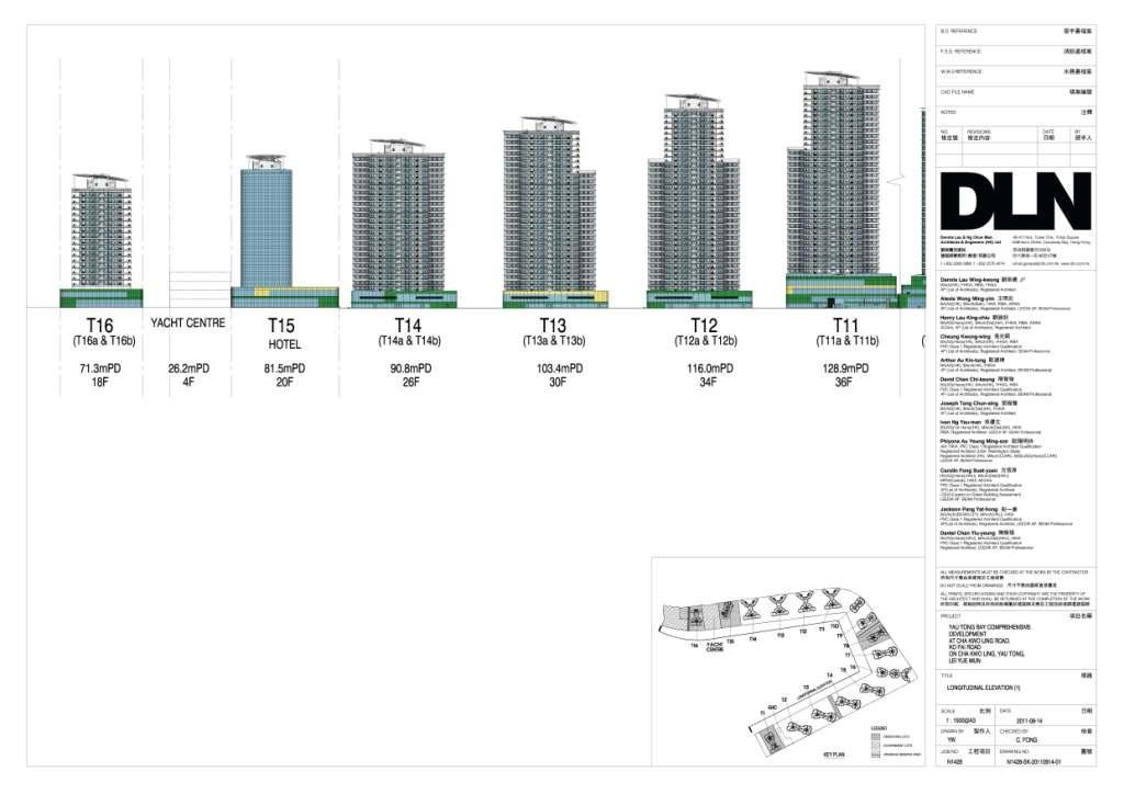
5 Task Force on Harbourfront Developments in Kowloon, Tsuen Wan and Kwai Tsing Page 5 TFK/14/2011 general public to enjoy the waterfront. Also important has been the design objective to create an innovative and attractive landmark for the emerging residential/tourism node around the South East Kowloon/Yau Tong/Lei Yue Mun Area. 24. The improved performance of the Current Scheme against the Harbour Planning Guidelines is highlighted below: Public Engagement 25. The Draft Planning Brief for the subject CDA was commented by Kwun Tong District Council and the Harbour-front Enhancement Committee prior to being finalized. 26. The Section 16 Planning Application was submitted on and subsequently published for Public Comment for 3 weeks, during which time only 12 comments were received. Amongst these comments, there were 5 supporting, 3 opposing and 4 neutral comments. In sum, the supporting comments were made in regards to the following reasons: redevelopment of vacant land; more job opportunities; improved visual quality of the area; conformed Stepped Building Height Design principle along the waterfront and a vibrant Public Waterfront Promenade. Opposing comments were made in relation to the Building Height, insufficient notification and liaison with dissenting lot owners in the CDA zone and not in line with the planning principle of the CDA zone. 27. To address the various comments received from Government Departments, the Public and major stakeholders, such as the TFK, the Current Scheme, has been subject to several rounds of modifications. As one key example, the Current Scheme has incorporated a potential Yacht Centre to activate the marine basin through boat berthing and other associated facilities for the general public. Land Use Planning Continuous Public Waterfront Promenade 28. In order to provide a min.15m public waterfront promenade, the Applicant has actively liaised with relevant Government Department to relocate the CKLSWPS and Maintenance Depot. Having advised that the Maintenance Depot will be removed, the area was thus incorporated for Public Waterfront Promenade and recreational use. On the other hand, the CKLSWPS is relocated to make way for the Public Waterfront Promenade and a potential Yacht Centre as mentioned in Paragraph above. Diversity of Uses 29. The Current Scheme includes a comprehensive range of complementary uses to promote vibrancy & enhance public enjoyment at the
6 Task Force on Harbourfront Developments in Kowloon, Tsuen Wan and Kwai Tsing Page 6 TFK/14/2011 Harbourfront (i.e. Open space, Recreation / Leisure, Tourism, Commercial / Retail uses). A variety of recreational / leisure activities will be provided at the Promenade, promoting the Harbourfront as a tourist attraction. In addition, a total of 5,752 flats are proposed in the Current Scheme to meet housing demands whilst ancillary facilities in the form of, for instance, residents clubhouse, recreational area and gardens are proposed for private and public uses and enjoyment. 30. A max. 288-room hotel is also proposed to provide comprehensive services such as F&B, security, shops, meeting rooms, exhibition/convention halls and modern hotel amenities that help upgrade of Yau Tong Bay as a local tourism node, thereby integrating with the tourism development in Lei Yue Mun and Kai Tak in the long term. 31. A low-rise block is proposed to accommodate Government, Institutional and Community (G/IC) facilities including an integrated vocational rehabilitation services centre, hostel for moderately mentally handicapped persons, integrated children and youth services centre to serve the wider East Kowloon area. In addition, full consideration was given to relocating existing undesirable G/IC uses to allow for a safe, convenient and continuous Public Waterfront Promenade for the public. As such, the CKLSWPS is also proposed to be relocated within the G/IC Facilities Block to enable better use of the waterfront at its current site including the provision of a continuous Public Waterfront Promenade. A potential Yacht Centre with a GFA of 3,750m2 is proposed on the existing CKLSWPS Site. In addition, a 9-classroom kindergarten is provided to meet the requirement stated in the Hong Kong Planning Standards and Guidelines ( HKPSG ). The provision of G/IC facilities accounts for a GFA of 9,876m 2. Open Space, Recreation and Leisure Uses 32. The Current Scheme will enable the provision of a continuous Public Waterfront Promenade along the entire shore of Yau Tong Bay with a minimum width of 15m wide and comprising a total area of 24,700m 2. The landscaped Public Waterfront Promenade provides an attractive Open Space for both active and passive recreational facilities for public enjoyment. 33. Not less than 17,256m 2 of ancillary open space will be provided within the Current Scheme, complying with the HKPSG. A variety of recreational facilities including residents clubhouse and sitting-out areas in landscape gardens will be provided within the Current Scheme and the Open Space and amenities will be fully landscaped. Furthermore, the Maintenance Depot of the Civil Engineering Development Department will be removed to allow for recreational usage. 34. To ensure there are varieties of activities going on along the waterfront, there will be a jogging trail, Tai Chi area and paved area for walking and seating etc. These allow both the public and the residents to exercise along the Public Waterfront Promenade.
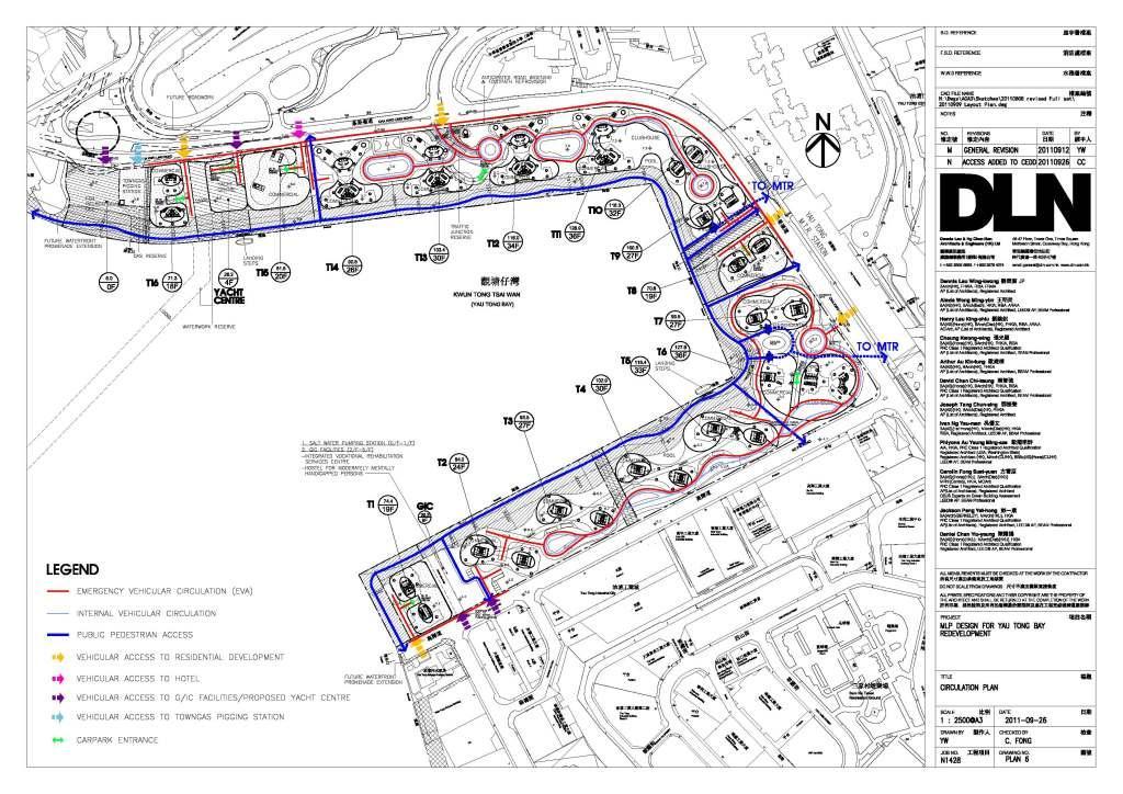
7 Task Force on Harbourfront Developments in Kowloon, Tsuen Wan and Kwai Tsing Page 7 TFK/14/ There are two public landing steps, one on the northern side of the harbour in front of the potential Yacht Centre and the other one in front of Tower 5 and 6 on the south side of the Bay. The berthing areas not only include generous sets of steps of boat docking/berthing facilities allowing access to boats, but also shaded waiting areas. Ancillary Commercial Facilities 36. The Current Scheme will include ancillary commercial facilities which will serve both the local residents as well as the general public, creating a vibrant environment. Other than a small component of commercial GFA allocated to shops and services offering daily convenience goods/services to the future residents, high-end restaurants and alfresco dining are also proposed to add vibrancy in the immediate neighbourhood as well as to the waterfront. Retailing and restaurants of the Current Scheme at street-level will attract visitors and tourist into the area, creating a sense of place and increasing the level of activities in the area and open space in close proximity. The commercial facilities will be developed with a festive maritime theme to integrate with the Harbour. With the continuous linkage along the Public Waterfront Promenade, local residents and visitors alike will be able to enjoy the new dining and retail experience to be provided on the Application Site. 37. Retail will be provided along the Public Waterfront Promenade as opposed to a conventional shopping mall to ensure that the waterfront is activated. Urban Design Building Height 38. The proposed building height of the Current Scheme is in line with the stepped building height principle as stated in the Explanatory Statement of the Approved OZP and the Planning Brief for the CDA site. The Current Scheme adopts a distinct stepped BH profile with descending BH towards the harbourfront (from the tallest of 128.9mPD inland to 71.3mPD at the western end compared) to avoid a monotonous Harbourfront image and wall effect. In addition, there were four Towers with a BH which exceeded 120mPD in the previous scheme whilst there are only two in the Current Scheme (i.e. Tower 5 and Tower 12 are reduced significantly by 12.9m and 9.5m, respectively). A reduction in BH was also achieved for Tower 7, Tower 8 and Tower 9 (i.e. the major view corridor of Yau Tong Bay), by 18.9m (from 118.4mPD to 99.5mPD), 13.9m (84.5mPD to 70.6mPD) and 9.5m (110mPD to 100.5mPD) respectively to minimise blockage of views for residents in Yau Tong Estate so that visual penetration towards the waterfront is ensured. Further to discussions with Planning Department, the stepped BH profile is enhanced with an average BH variation of 13.88m for the consortium lots. The lowest to the highest BH variation range from 9.3m to 29.9m (approx. 3-4 storeys difference) compared to the previous schemes of 1.7m to 33.9m. This is also sympathetic
8 Task Force on Harbourfront Developments in Kowloon, Tsuen Wan and Kwai Tsing Page 8 TFK/14/2011 to the wider urban design context which comprises existing high-rise public housing estates to the east and northeast, as well as the BH restrictions stipulated in the Yau Tong Industrial Area right to the south of the Site under the prevailing Approved OZP (Table 1 below demonstrates the difference between the BHs and the design aspects of the three schemes. Table 1 Comparison Table between the Building Height and Design Aspects Item Original Scheme (submitted in SPS on ) Previous Scheme (submitted in SIP No. 1 on ) Current Scheme (submitted in SIP No.2 on ) Building Height mPD mPD mPD No. of Towers over 120mPD 4 Towers Tower 5: 129.3mPD Tower 6: Tower 11: Tower 12: 125.5mPD 131mPD 132mPD 4 Towers Tower 5: 129.3mPD Tower 6: 131mPD Tower 11: 132mPD Tower 12: 125.5mPD 2 Towers Tower 6: 127.9mPD Tower 11: 128.9mPD Minimum width of 18.21m 18.21m 25m Permeable Zone Building Height 1.7m m 1.7m m 9.3m m Variation Average Variation 9.11m 9.12m 13.88m of Building Height (for consortium lots) Building Height of Towers 7, 8 and 9 (major view corridor to Yau Tong, in front of Yau Tong Estate) Tower 7: 118.4mPD Tower 8: 84.5mPD Tower 9: 110.1mPD Tower 7: 118.4mPD Tower 8: 84.5mPD Tower 9: 110.0mPD Tower 7: 99.5mPD (-18.9m) Tower 8: 70.6mPD (-13.9m) Tower 9: 100.5mPD (-9.5m) Sky Garden Provided Provided Removed to further reduce Building Height Noise Mitigation Measures - Semi-enclosed noise barriers extending over full width of northern Cha Kwo Ling Road - Semi-enclosed noise barriers extending over half of the road width along eastern Cha Kwo Ling Road. - Single Aspect Building Design -Noise canopies -Single Aspect Building Design -Noise canopies - Acoustic fins
9 Task Force on Harbourfront Developments in Kowloon, Tsuen Wan and Kwai Tsing Permeability TFK/14/ The Current Scheme maintains the principle of Louvre Blades as far as possible to maximise air ventilation and visual permeability within the Site. Notwithstanding the need for SAB within the Current Scheme to mitigate against traffic noise, the tower dispositions are also revised to ensure permeable zones between building blocks with a minimum of width of 25m. Some permeable zones are higher than the minimum requirement of the Planning Brief (i.e. 25m), resulting in an average width of 26.89m. The podiums are minimised to enable physical and visual permeability to the waterfront. In addition, the parking provision for the Current Scheme are provided at basement level instead of adopting the conventional practice to accommodate carparking and commercial uses in a bulky podium structure covering the entire site. 40. Aside from towers situated along the northern portion of the Application Site which are designed to mitigate against noise from Cha Kwo Ling Road, an aerodynamic building footprint with Green Sleeves, Podium Gardens and Rooftop Gardens are proposed to enhance air flow between the buildings as well as to ensure penetration of sunlight and enjoyment of views over Yau Tong Bay and beyond the Harbour. Perspective drawings for the Current Scheme are provided at Appendix It is confirmed that the Latest Scheme fully complies with the Sustainable Building Guidelines ( SBG ) promulgated by the Buildings Department ( BD ) in April 2011 in terms of building separation and permeability. Streetscape Design 42. In addition to the Public Waterfront Promenade which will be fully landscaped for the public enjoyment, the interface between the Current Scheme, Ko Fai Road and Cha Kwo Ling Road will be planted with large trees to visually enhance the streetscape. At locations where podiums are situated close to the site boundary, terraced planters will be used to achieve vertical greening. 43. A number of the towers are open at ground floor level, reducing the possible sense of enclosure and providing the opportunity to continue the soft landscaping treatment within the footprint of the building. Shade tolerant planting, such as appropriate shrubs, ferns and grasses will be used in these areas to further enhance the ground floor visually and ecologically. 44. Large tree planting at podium levels will also be visible from the street level. In addition, the towers along Ko Fai Road are orientated to maintain views across the Site and beyond to Yau Tong Bay. Breaks in vegetation and clear signage will clearly define pedestrian access from Ko Fai Road and Cha Kwo Ling Road to the Public Waterfront Promenade. Page 9
10 Task Force on Harbourfront Developments in Kowloon, Tsuen Wan and Kwai Tsing Landscaping Page 10 TFK/14/ The Greening Ratio of the Public Waterfront Promenade in the Current Scheme reaches 60%. Also, the Current Scheme provides a 32% Greening Ratio of the Site (private area), of which 20% is ground floor greening. 46. There are practical constraints to the extent to which planting can be provided on the Promenade due to the provision of recreational facilities as required in the Planning Brief. In fact, the realistic area that is available for planting on the Promenade is 60.38%. Allowing also for drainage reserves and temporary access tracks which must be provided across the Promenade, therefore, this calculation demonstrates that in achieving a green cover of 60%, the MLP as presented has provided a very reasonable green coverage, given the requirements of the Planning Brief. 47. Vertical greening will be achieved / incorporated through climbing plants / green wall systems along Ko Fai Road and Cha Kwo Ling Roads; climbing plants on stepped / terrace planters at the Public Waterfront Promenade and trailing plants on footbridges / podium roofs. 48. The Landscape Master Plan for the Current Scheme is shown in Appendix 5. A main concept behind the Landscape Proposal is to create an attractive environment to bring the people to the Harbour and the Harbour to the people in line with the Harbour Planning Framework, mainly viz. provision of a landscaped Public Waterfront Promenade. New plantings comprising of a mix of native and exotic flowering trees and shrubs and thematic plantings will be provided to increase aesthetic effect and to lighten up the environment, thus, creating an attractive Public Waterfront Promenade. This is also in line with the requirement stated in the Approved OZP, which requires provision of recreational facilities along the Public Waterfront Promenade to add vibrancy to the waterfront. Physical Linkage 49. The Application Site is currently occupied by industrial uses that prohibit access to the waterfront. The Current Scheme aims to open up the waterfront so as to allow an accessible harbour. The Public Waterfront Promenade will be easily accessible directly from MTR Yau Tong Station via two footbridges at each end of Yau Tong Station and six pedestrian accesses from ground level. There will be 24-hour covered/uncovered pedestrian walkways which welcome the public to enjoy the waterfront at all hours. The proposed linkages provide direct, safe and barrier-free linkages to the Harbourfront. 50. Public landing steps for berthing are proposed to be incorporated within the Public Waterfront Promenade in front of Tower 5 and Tower 6 as well as in front of the potential Yacht Center, allowing concurrent mooring and servicing of little pleasure boats, which helps to reinforce Yau Tong Bay
11 Task Force on Harbourfront Developments in Kowloon, Tsuen Wan and Kwai Tsing Page 11 TFK/14/2011 as an activity and tourism node in Kowloon East. One of the proposed public landing steps will be in close proximity to the MTR Station, thus, inviting the general public to the Harbourfront. This will also become a main feature for the proposed hotel, creating potential for an integrated tourism network with other attractions along Victoria Harbour (Plan 7.1 to 7.3 of Appendix 3 refers). Land Formation 51. The Current Scheme has been developed on the general principle and approach of no reclamation. Extensive dredging would not be anticipated under the current scheme; but dredging may be required in inner Yau Tong Bay to maintain the water depth for the purpose of navigation subject to the size of marine vessels allowed due to the proposed public landing steps. Harbour-Front Management 52. The Public Waterfront Promenade and boat docking/berthing facilities will allow both the public and private to have an easy access to the Harboufront but at the same time not affecting the privacy of the residence. In order to integrate the public area and the private area cohesively, the abovementioned facilities will be maintained and managed by LCSD and the Applicant. Together with the Leisure and Cultural Services Department s close monitoring, the Public Waterfront Promenade will become an attractive urban escape. In addition, the preservation of the existing pontoon will be reviewed by the Applicant if the pontoon, which is the property of the tenant, remains in-situ. Sustainable Development 53. Technical Assessments have demonstrated that the Current Scheme is sustainable on the Application Site and will NOT generate any insurmountable traffic, environmental, engineering or visual impacts on the surrounding area. 54. Innovative and green building principles that have been adopted through the following measures: Careful Disposition/Orientation of the Blocks to maximize view corridor and breezeways The Current Scheme will provide a minimum width of 25m permeable zones between building blocks, complying with the Planning Brief. As some of the permeable zones are wider than 25m, this gives an average width of 26.89m, which exceeds the minimum requirement in the Planning Brief. This careful disposition of building blocks will not only allow penetration of prevailing wind, but will also preserve views for adjacent developments. Furthermore, such arrangement enables the main façade of the blocks to be
12 Task Force on Harbourfront Developments in Kowloon, Tsuen Wan and Kwai Tsing TFK/14/2011 set-back from major roads to minimise the impact of noise from the roads to the future residents. Aerodynamic Building Form to Enhance Airflow The aerodynamic shape of the building façade for most of the Towers will enhance air circulation to the neighbourhood with smooth building edges. The aerodynamic profile will enhance the flow of air along the building blocks with minimum resistance and permit smooth passage of wind blowing from a wider spectrum of directions. Avoiding Bulky Podium Structures Instead of adopting the conventional practice to accommodate carparking and commercial uses in a bulky podium structure covering the entire site, the Applicant proposes to allocate all parking facilities underground. This will maximize opportunities for street level greening, visual permeability and natural airflow through the Application Site. Although podium structures can be found in the eastern portion of the Site, they are stepped to connect with the major Gateway, the Yau Tong MTR Station. They are in fact bridges that bring the people to the Harbour and the Harbour to the people. This will also provide a convenience to the whole community. Furthermore, the opening up of passages between and within the podiums will help to reduce any adverse visual impact and enhance street ventilation. Maximise Green Opportunities The landscaped area along the Public Waterfront Promenade, vertical greening and roof landscapes will be provided to the podiums and will enhance the visual interest of the Current Scheme and benefit the community overall. Tourism Integration The redevelopment of the Application Site will replace the existing obsolete industrial developments with a pleasant residential area and a Hotel building with Public Waterfront Promenade. Temporary Land Uses 55. The Public Waterfront Promenade with 24,700m2 will be implemented in three phases for early public enjoyment. The Public Waterfront Promenade will be of at least 7.5m wide and 12,176m2 in Phase I (2017) in order to establish a proper buffer between the works area and the Promenade. A temporary pedestrian connection (between Tower 7 & Tower 8) will be arranged from Cha Kwo Ling Road to the Public Waterfront Promenade accordingly for convenient linkage. The Public Waterfront Promenade of a minimum width of 15m will be gradually opened up at the remaining area (Plan of Appendix 3 refers). Page 12
13 Task Force on Harbourfront Developments in Kowloon, Tsuen Wan and Kwai Tsing SUMMARY OF OTHER PLANNING JUSTIFICATIONS Page 13 TFK/14/ As demonstrated above in Section 4, the Current Scheme is in line with the Harbour Planning Guidelines and Vision to make Victoria Harbour attractive, vibrant, accessible and symbolic of Hong Kong: a harbour for people and a harbour of life. In formulating the Current Scheme, the prime objective has been to achieve an optimal scheme in compliance with the statutory and non-statutory requirements relevant to the Site as prescribed in the Approved OZP and the relevant Planning Brief, to improve the environmental and visual qualities of the Area, to proactively implement the statutory planning intention for the Area and ensure compatibility with the existing developments in the surrounding areas (which is mainly comprise high rise public and private residential buildings, vacant industrial buildings and warehouses). 57. The Current Scheme with Minor Relaxation of the BH and PR is perfectly in line with the TPB/Government s intention to facilitate restructuring of obsolete areas and to phase out incompatible development and non-conforming uses in the CDA zones. It is also in line with public aspirations by achieving urban renewal in the metro area. The Current Scheme will create an attractive and well-patronised waterfront by revitalise the current unwelcoming environment. The proposed maximum PR of 5 (inclusive of the GFA of the G/IC facilities) is consistent with the maximum PR allowable under the Statutory Notes of the Approved OZP and is in fact materially lower than the recommended PR under the HKPSG (viz. a PR of 6 for Residential Density Zone 1 in which the Application Site is located). 58. The re-provisioning of the existing CKLSWPS to integrate with the proposed low-rise G/IC Facilities Block (between Tower 1 & Tower 2) will not only provide a more comprehensive development but also resolve the issue of restrictive access to the Public Waterfront Promenade, such that a continuous Public Waterfront Promenade with a minimum width of 15m for public enjoyment will be provided. Importantly, the reprovisioning of the CKLSWPS will also enable the following PPGs: convenient accessibility to the Harbourfront; removal of an undesirable visual and land use interface caused by the existing CKLSWPS on the proposed Promenade; efficient provision of an Integrated G/IC Facilities Block within the Proposed Development to serve the public and a newly freed up area dedicated for Recreational Use / Yacht Centre. 59. The Current Scheme has incorporated significant design merits, e.g. adopting a visually interesting and aerodynamic building form, avoiding bulky podium structures, creating a visually interesting harbour image with diversity in building mass and varying roof heights, etc. It will bring significant public planning gains to the public, e.g. realisation of the planning intention and provision of an impetus to urban renewal; removal of the existing dilapidated industrial buildings and associated environmental impacts; provision of a Public Waterfront Promenade and provision of public landing steps to facilitate berthing; provision of G/IC facilities; enhancement
14 Task Force on Harbourfront Developments in Kowloon, Tsuen Wan and Kwai Tsing TFK/14/2011 on the quality of the landscape within the Application Site; provision of a balanced housing mix; and enhanced local employment opportunities for improvement to local socio-economic conditions. 60. Lastly, the Current Scheme is also assessed to be acceptable in terms of visual and technical impacts. CONCLUSION 61. In light of the justifications provided and the genuine efforts by the Applicant to achieve a beneficial scheme to the Public, the TFK is invited to give its support to the Current Scheme. Main Wealth Development Limited October 2011 APPENDICES APPENDIX 1 APPENDIX 2 APPENDIX 3 APPENDIX 4 APPENDIX 5 APPENDIX 6 PREVIOUS PAPER PRESENTED ON TO THE HARBOURFRONT COMMISSION BROAD DEVELOPMENT PARAMETERS OF THE CURRENT SCHEME ARCHITECTURAL DRAWINGS PRELIMINARY STUDY FOR YACHT CENTRE IN YAU TONG BAY LANDSCAPE MASTER PLAN PERSPECTIVE DRAWINGS Page 14
15 Task Force on Harbourfront Developments in Kowloon, Tsuen Wan and Kwai Tsing For discussion on 16 March 2011 TFK/04/2011 PROPOSED DISTRICT REVITALISATION WITH MINOR RELAXATION OF BUILDING HEIGHT AND PLOT RATIO RESTRICTIONS IN THE COMPREHENSIVE DEVELOPMENT AREA ZONING AT YAU TONG BAY 1. PURPOSE 1.1 Main Wealth Development Limited has submitted a Section 16 Planning Application to the Town Planning Board (TPB) in respect of a Proposed District Revitalisation Scheme, which incorporates a Comprehensive Composite Residential Development (the Proposed Development ) with associated public planning gains. Given the potential of the Proposed Development to enhance and revitalize the area around Yau Tong Bay, the Harbourfront Commission is requested to provide their in-principle support to this Project. 2. BACKGROUND & HISTORY 2.1 According to the Selected Strategy of Metroplan endorsed by the Executive Council in September 1991, Yau Tong Marine Lots and the adjoining Bay were designated Comprehensive Development Area ( CDA ) to facilitate private residential/commercial development and associated community uses. 2.2 The Yau Tong Bay CDA, was subsequently incorporated into the Draft Cha Kwo Ling, Yau Tong, Lei Yue Mun Outline Zoning Plan (OZP No.S/K15/6) exhibited on The CDA scheme covered an area of about ha, of which about 9.13 ha was to be reclaimed. In 2002, the boundary of the CDA was further expanded from ha to 22 ha (of which ha to be reclaimed) and incorporated into the OZP No. S/K15/ However, in an effort to reduce the development intensities and building heights of the potential development on the CDA, revised development parameters were incorporated into the Draft Cha Kwo Ling, Yau Tong, Lei Yue Mun OZP No. S/K15/16 (which also included a revision to the boundary of the Yau Tong Bay CDA by excising the water area from the CDA zone as per the no reclamation approach ). Subsequently, the Approved Cha Kwo Ling, Yau Tong, Lei Yue Mun OZP No. S/K15/17 was gazetted on with Building Height Restrictions incorporated. 2.4 The Draft Planning Brief in respect of the subject CDA was endorsed by the TPB on The Brief was revised in response to views raised by District Council and the Harbourfront Enhancement Committee, and subsequently endorsed by the TPB on On , the Applicant submitted a Section 16 Planning Application for the Proposed Development under the Draft Cha Kwo Ling, Yau Tong, Lei Yue Mun OZP No. S/K15/18. This Application is still under processing and the Applicant is in active discussions with relevant Government Departments and stakeholders to address comments received. 3. THE PROPOSED DEVELOPMENT 3.1 The Application Site has long been zoned CDA for comprehensive restructuring of the existing obsolete industrial buildings on the Site. The Proposed Development is in line with the planning intention in respect of the CDA zone which is to facilitate comprehensive development/redevelopment of the area for residential and/or commercial uses with the
16 Task Force on Harbourfront Developments in Kowloon, Tsuen Wan and Kwai Tsing TFK/04/2011 provision of open space and other community and supporting facilities as stated in the Draft OZP. 3.2 The Proposed Development is a comprehensive, mixed-used scheme, including residential use alongside hotel, commercial, recreational and G/IC facilities with a continuous Public Waterfront Promenade. 3.3 The Applicant has also proposed a Minor Relaxation of the Building Height (BH) Restriction from 120mPD to maximum 132mPD, and Plot Ratio (PR) from 4.5 to 5.0 to allow for a more prestigious and attractive waterfront development. The proposed Minor Relaxations of PR have fulfilled all the preset requirements prescribed by the TPB as stipulated in the OZP and Planning Brief including the amalgamation of over 80% of private land within the CDA zone. 3.4 Development parameters of the Proposed Development (Appendix 1 refers) together with Architectural Drawings (Appendix 2 refers) are provided. 4. CONFORMITY WITH THE HARBOUR PLANNING GUIDELINES 4.1 Introduction Given the prominence of the Site at Yau Tong Bay near the eastern gateway of Victoria Harbour, every effort has been made to ensure a development that not only provides a quality living environment for its residents, but can also provide opportunities for the general public to enjoy the waterfront. Also important has been the design objective to create an innovative and attractive landmark for the emerging residential/tourism node around the South East Kowloon/Yau Tong/Lei Yue Mun Area Assessment of the Proposed Development against the Harbour Planning Guidelines has been undertaken to demonstrate that full consideration has been given to achieve a positive, effective and balanced utilization of land and marine resources. 4.2 Public Engagement The Draft Planning Brief for the subject CDA was commented by District Council and the Harbourfront Enhancement Committee prior to being finalized The Section 16 Planning Application was submitted on and subsequently published for Public Comment for 3 weeks, during which time only 12 comments were received. Amongst these comments, there were 5 supporting, 3 opposing and 4 neutral comments. In sum, the supporting comments were made in regards to the following reasons: redevelopment of vacant land; more job opportunities; improved visual quality of the area; conformed Stepped Building Height Design principle along the waterfront and a vibrant Public Waterfront Promenade. Opposing comments were made in relation to the Building Height, insufficient notification and liaison with dissenting lot owners in the CDA zone and not in line with the planning principle of the CDA zone To address the various Public and Government comments, the Applicant has made amendments to the Original Scheme and prepared a Revised Scheme which was submitted as a Supplementary Information Paper to the TPB on This consultation with Habourfront Commission also reflects the willingness of the Applicant to consult with key stakeholders. Page 2
17 Task Force on Harbourfront Developments in Kowloon, Tsuen Wan and Kwai Tsing TFK/04/ Land Use Planning Diversity of Uses The Proposed Development includes a comprehensive range of complementary uses to promote vibrancy & enhance public enjoyment at the Harbourfront (i.e. Open space, Recreation / Leisure, Tourism, Commercial / Retail uses). A variety of recreational / leisure activities will be provided at the Promenade, promoting the Harbourfront as a tourist attraction. In addition, a total of 6,014 flats are proposed in the Revised Scheme to meet housing demands whilst ancillary facilities in the form of, for instance, residents clubhouse, recreational area and gardens are proposed for private and public uses and enjoyment A max. 320-room hotel is also proposed to provide comprehensive services such as F&B, security, shops, meeting rooms, exhibition/convention halls and modern hotel amenities that help upgrade of Yau Tong Bay as a local tourism node, thereby integrating with the tourism development in Lei Yue Mun and Kai Tak in the long term A low-rise block is proposed to accommodate Government, Institutional and Community (G/IC) facilities including an integrated vocational rehabilitation services centre, hostel for moderately mentally handicapped persons, integrated children and youth services centre to serve the wider East Kowloon area. In addition, full consideration was given to relocating existing undesirable G/IC uses to allow for a safe, convenient and continuous Waterfront Promenade for the public. As such, the Cha Kwo Ling Salt Water Pumping Station is also proposed to be relocated within the G/IC block to enable better use of the waterfront at its current site including the provision of a continuous Public Waterfront Promenade. In addition, a 6-classroom kindergarten is provided to meet the requirement stated in the Hong Kong Planning Standards and Guidelines ( HKPSG ). Open Space, Recreation and Leisure Uses The Proposed Development will enable the provision of a Public Waterfront Promenade along the entire shore of Yau Tong Bay with a minimum width of 15m wide and comprising a total area of 24,700 m 2. The landscaped Waterfront Promenade provides an attractive Open Space for both active and passive recreational facilities for public enjoyment. Furthermore, the Maintenance Depot of the Civil Engineering Development Department will be removed to allow for recreational usage. A possible use may include a Marina Club to allow for marine-based recreation Not less than 18,042 m 2 of ancillary open space will be provided within the Proposed Development, complying with the Hong Kong Planning Standards and Guidelines. A variety of recreational facilities including Sky Gardens in all the residential blocks, residents clubhouse and sitting-out areas in landscape gardens will be provided within the Proposed Development and the Open Space and amenities will be fully landscaped Among the variety of Open Space and recreational facilities, the Sky Gardens form a crucial design and landscape element. In addition to visually softening the building mass and improving wind and visual permeability within the Site, the Sky Gardens also help create more Open Space and provide more greenery/planting opportunities throughout the Site To ensure there are varieties of activities going on along the waterfront, there will be an 1,152m long jogging trail, Tai Chi area and paved area for walking and seating etc. These allow both the public and the residents to exercise along the Public Waterfront Promenade. Page 3
18 Task Force on Harbourfront Developments in Kowloon, Tsuen Wan and Kwai Tsing TFK/04/ There are two boat docking/berthing facilities, one on the northern side of the harbour in front of the Town Gas Pigging Station and the other one in front of Tower 4 and 5 on the south side of the Bay. The berthing areas include generous sets of steps allowing access to boats, as well as shaded waiting areas. Ancillary Commercial Facilities The Proposed Development will include ancillary commercial facilities which will serve both the local residents as well as the general public, creating a vibrant environment. Other than a small component of commercial GFA allocated to shops and services offering daily convenience goods/services to the future residents, high-end restaurants and alfresco dining are also proposed to add vibrancy in the immediate neighbourhood as well as to the waterfront. Retailing and restaurants of the Proposed Development at street-level will attract visitors and tourist into the area, creating a sense of place and increasing the level of activities in the area and open space in close proximity. The commercial facilities will be developed with a festive maritime theme to integrate with the Harbour. With the continuous linkage along the Public Waterfront Promenade, local residents and visitors alike will be able to enjoy the new dining and retail experience to be provided on the Application Site. 4.4 Urban Design Development Intensity A maximum PR of 5 is sought (inclusive of GFA of G/IC facilities) consistent with the maximum PR allowable under the Statutory Notes of the OZP. The development intensity is compatible with the PR restriction of the nearby R(E) zone (viz. maximum domestic PR of 5 and non-domestic PR of 1), the PR pertaining to the Planning Approvals in the adjacent Yau Tong Industrial Area (viz. a total PR of 6 to 6.6) and the proposed medium-density Harbourfront residential development in the Kai Tak new development area [i.e. a maximum PR of 5 for the Harbourfront Residential (Group B) zone in Kai Tak]. Furthermore, it will not result in any adverse impacts on infrastructure or the environment of the Area. Building Height The proposed building height of the Proposed Development is in line with the stepped building height principle as stated in the Explanatory Statement of the Draft OZP and the Planning Brief for the CDA site. The Proposed Development adopts a distinct stepped building height profile with descending building height towards the harbourfront (from the tallest of 132mPD inland to 70mPD at the two western ends) to avoid a monotonous Harbourfront image and wall effect. This is also sympathetic to the wider urban design context which comprises existing high-rise public housing estates to the east and northeast, as well as the building height restrictions stipulated in the Yau Tong Industrial Area right to the south of the Site under the prevailing Draft OZP. Permeability To maximise air ventilation and visual permeability within the Site, the building blocks are arranged according to the principle of Louvre Blades to promote desirable passage of air and daylight between them blocks, and crucially, to maximize view corridors to Yau Tong Bay and the harbour beyond. The Proposed Development has incorporated permeable zones between building blocks with an average width of 31.36m and podiums are minimized to enable physical and visual permeability to the waterfront. In addition, the parking provision for the Proposed Development are provided at basement level instead of adopting the Page 4
19 Task Force on Harbourfront Developments in Kowloon, Tsuen Wan and Kwai Tsing TFK/04/2011 conventional practice to accommodate carparking and commercial uses in a bulky podium structure covering the entire site Aside from towers situated along the northern portion of the Application Site which are designed to mitigate against noise from Cha Kwo Ling Road, an aerodynamic building footprint with Green Sleeves, Podium Gardens and Sky Gardens are proposed to enhance air flow between the buildings as well as to ensure penetration of sunlight and enjoyment of views over Yau Tong Bay and beyond the Harbour. Streetscape Design In addition to the public Waterfront Promenade which will be fully landscaped for the public enjoyment, the interface between the Proposed Development, Ko Fai Road and Cha Kwo Ling Road will be planted with large trees to visually enhance the streetscape. At locations where podiums are situated close to the site boundary, terraced planters will be used to achieve vertical greening A number of the towers are open at ground floor level, reducing the possible sense of enclosure and providing the opportunity to continue the soft landscaping treatment within the footprint of the building. Shade tolerant planting, such as appropriate shrubs, ferns and grasses will be used in these areas to further enhance the ground floor visually and ecologically Large tree planting at podium levels will also be visible from the street level. In addition, the towers along Ko Fai Road are orientated to maintain views across the Site and beyond to Yau Tong Bay. Breaks in vegetation and clear signage will clearly define pedestrian access from Ko Fai Road and Cha Kwo Ling Road to the Public Waterfront Promenade. 4.5 Landscaping The objective of the landscape design is to create a quality living environment with due respect to the surrounding environment. Greening opportunities will be maximised in the form of Sky Gardens and vertical Green Sleeves cutting through the body of most of the residential towers. The Landscape Master Plan for the Proposed Development is shown in Appendix 3. A main concept behind the Landscape Proposal is to create an attractive environment to bring the people to the Harbour and the Harbour to the people in line with the Harbour Planning Framework, mainly viz. provision of a landscaped Public Waterfront Promenade. New plantings comprising of a mix of native and exotic flowering trees and shrubs and thematic plantings will be provided to increase aesthetic effect and to lighten up the environment, thus, creating an attractive Waterfront Promenade. This is also in line with the requirement stated in the Draft OZP, which requires provision of recreational facilities along the waterfront promenade to add vibrancy to the waterfront. 4.6 Physical Linkage The Application Site is currently occupied by industrial uses that prohibit access to the waterfront. The Proposed Development aims to open up the waterfront so as to allow an accessible harbour. The waterfront promenade will be easily accessible directly from MTR Yau Tong Station via two footbridges at each end of Yau Tong Station and seven pedestrian accesses from ground level. There will be 24-hour covered/uncovered pedestrian walkways which welcome the public to enjoy the waterfront at all hours. The proposed linkages provide direct, safe and barrier-free linkages to the Harbourfront. Page 5
20 Task Force on Harbourfront Developments in Kowloon, Tsuen Wan and Kwai Tsing TFK/04/ The major public access to the waterfront promenade at the south-eastern corner of the bay will be accompanied by an open area with water features and sitting out facilities. There will also be retail and alfresco dining around the plaza to enhance the vibrancy and to create a welcoming environment to the general public. In addition, escalators will be provided to allow a convenient and barrier-free access to the waterfront promenade Landing steps for berthing are proposed to be incorporated within the Public Waterfront Promenade in front of T4 and T5, allowing concurrent mooring and servicing of little pleasure boats, which helps to reinforce Yau Tong Bay as an activity and tourism node in Kowloon East. The proposed landing steps will be in close proximity to the MTR Station, thus, inviting the general public to the Harbourfront. This will also become a main feature for the proposed hotel, creating potential for an integrated tourism network with other attractions along Victoria Harbour (Plan 7.1 to 7.3 of Appendix 2 refers). 4.7 Land Formation The Proposed Development has been developed on the general principle and approach of no reclamation. Extensive dredging would not be anticipated under the current scheme and dredging would only be restricted to seawall construction along the waterfront and for odour mitigation measures. Although extensive dredging is not expected under the current scheme, maintenance dredging is considered necessary in order to maintain the water depth within Yau Tong Bay for the purpose of navigation. With the implementation of appropriate mitigation measures, adverse environmental impacts are not anticipated. Further studies and investigations will be undertaken for detailed assessment of the existing seawalls. 4.8 Harbour-Front Management The Public Waterfront Promenade and boat docking/berthing facilities will allow both the public and private to have an easy access to the Harboufront but at the same time not affecting the privacy of the residence. In order to integrate the public area and the private area cohesively, the abovementioned facilities will be maintained and managed by the Applicant. Together with the Leisure and Cultural Services Department s close monitoring, the Public Waterfront Promenade will become an attractive urban escape. In addition, the preservation of the existing pontoon will be reviewed by the Applicant if the pontoon, which is the property of the tenant, remains in-situ. 4.9 Sustainable Development Technical Assessments have demonstrated that the Proposed Development is sustainable on the Application Site and will NOT generate any insurmountable traffic, environmental, engineering or visual impacts on the surrounding area Innovative and green building principles that have been adopted through the following measures: Careful Disposition/Orientation of the Blocks and Aerodynamic Building Form to Enhance Natural Ventilation and Visual Permeability The Proposed Development will provide 31.36m (average) permeable zones between building blocks. This careful disposition of building blocks does not only allow penetration of prevailing wind, but also preserves view for adjacent development. There will be two Sky Gardens and vertical Green Sleeves cutting through the body of each residential tower. These provide a greater spatial relief to the future residents and also ensure visual Page 6
21 Task Force on Harbourfront Developments in Kowloon, Tsuen Wan and Kwai Tsing TFK/04/2011 penetration from the surroundings to the waterfront. Moreover, the aerodynamic shape of the building façade helps to encourage air circulation to the neighbourhood. Furthermore, such arrangement enables the main façade of the blocks to be set-back from major roads to minimise the impact of noise from the roads to the future residents. Avoiding Bulky Podium Structures Instead of adopting the conventional practice to accommodate carparking and commercial uses in a bulky podium structure covering the entire site, the Applicant proposes to allocate all parking facilities underground. This will maximize opportunities for street level greening, visual permeability and natural airflow through the Application Site. Maximise Green Opportunities Sky Gardens are provided within the residential blocks to improve visual permeability, light penetration and a double green effect (i.e. contiguous street level landscape plus Sky Garden landscape) for pedestrians at street level Temporary Land Uses The Public Waterfront Promenade with 24,700m 2 will be implemented in three phases for early public enjoyment. The Public Waterfront Promenade will be of at least 7.5m wide and 16, m 2 in Phase I (2016) in order to establish a proper buffer between the works area and the Promenade. Temporary pedestrian connections will be arranged from Cha Kwo Ling Road to the Public Waterfront Promenade accordingly for convenient linkage. The Public Waterfront Promenade of 15-20m will be gradually opened up at the remaining area (Plan 5 of Appendix 2 refers). 5. SUMMARY OF OTHER PLANNING JUSTIFICATIONS 5.1 As demonstrated above in Section 4, the Proposed Development is in line with the Harbour Planning Guidelines and Vision to make Victoria Harbour attractive, vibrant, accessible and symbolic of Hong Kong: a harbour for people and a harbour of life. In formulating the Proposed Development, the prime objective has been to achieve an optimal scheme in compliance with the statutory and non-statutory requirements relevant to the Site as prescribed in the Draft OZP and the relevant Planning Brief, to improve the environmental and visual qualities of the Area, to proactively implement the statutory planning intention for the Area and ensure compatibility with the existing developments in the surrounding areas (which is mainly comprise high rise public and private residential buildings, vacant industrial buildings and warehouses). 5.2 The Proposed Development with Minor Relaxation of the BH and PR is perfectly in line with the TPB/Government s intention to facilitate restructuring of obsolete areas and to phase out incompatible development and non-conforming uses in the CDA zones. It is also in line with public aspirations by achieving urban renewal in the metro area. The Proposed Development will create an attractive and well-patronised waterfront by revitalise the current unwelcoming environment. 5.3 The Proposed Development has incorporated significant design merits, e.g. adopting a visually interesting and aerodynamic building form, avoiding bulky podium structures, providing Sky Gardens, creating a visually interesting harbour image with diversity in building mass and varying roof heights, etc. It will bring significant public planning gains to the public, e.g. realisation of the planning intention and provision of an impetus to urban renewal; Page 7
22 Task Force on Harbourfront Developments in Kowloon, Tsuen Wan and Kwai Tsing TFK/04/2011 removal of the existing dilapidated industrial buildings and associated environmental impacts; provision of a Public Waterfront Promenade and provision of public landing steps to facilitate berthing; provision of G/IC facilities; enhancement on the quality of the landscape within the Application Site; provision of a balanced housing mix; and enhanced local employment opportunities for improvement to local socio-economic conditions. 5.4 Lastly, the Proposed Development is also assessed to be acceptable in terms of visual and technical impacts. 6. CONCLUSION 6.1 In light of the justifications provided, the Commission is invited to give support to the Proposed Development. 7. Appendices Appendix 1 - Broad Development Parameters of the Applied Development (Gist) Appendix 2 - Architectural Drawings Appendix 3 - Landscape Master Plan/ Perspectives Appendix 4 - Photomontages Main Wealth Development Limited March 2011 Page 8
23
24
25
26
27

28


29
30
31
32
33
34
35
36
37
38
39
40
41
42
43
44

45
46

47
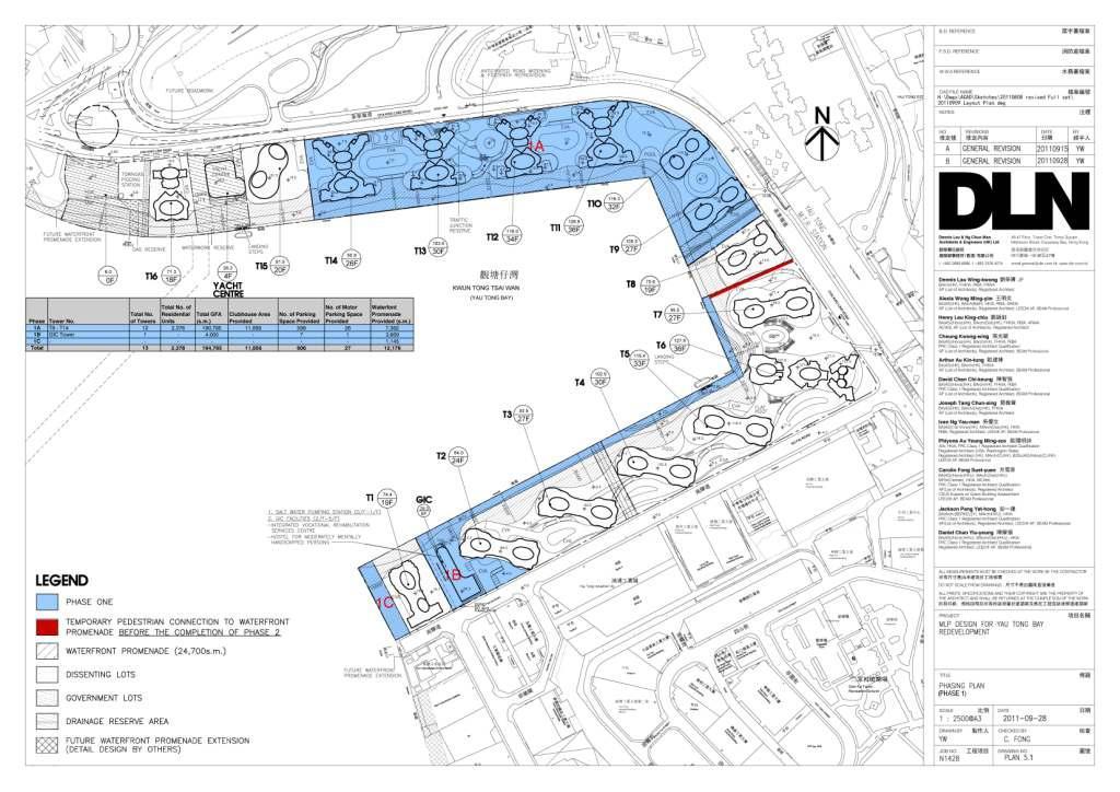
48

49
50
51 Technical Schedule of the Proposed Development Item Original Scheme [a] (submitted ) SIP No.1 Scheme [b] (submitted ) Difference [b] [a] Latest Scheme [c] Difference [c] [a] Difference [c] [b] Site Area Approx. 99,418 m 2 Approx. 99,418 m 2 No Change Approx. 99,418 m 2 No Change No Change Total Plot Ratio Not more than 5 (including G/IC Facilities) Not more than 5 (including G/IC Facilities) No Change Not more than 5 (including G/IC Facilities) No Change No Change Total GFA Not more than 497,090 m 2 Not more than 497,090 m 2 No Change Not more than 497,090 m 2 No Change No Change No. of Blocks No Change 32 (comprises two building blocks for Towers 1-5, 7-14 & 16, three building blocks for Tower 6 &1 Hotel (Tower 15) Site Coverage Building Height (Main Roof Level) Comparison between the Maximum and Minimum BH Maximum Domestic Plot Ratio Above 61m (Domestic): Approx % Above 61m (Non-Domestic): Approx % Adopted a Stepped Building Height ranging from 70mPD to 132mPD Above 61m (Domestic): Approx % Above 61m (Non-Domestic): Approx % Adopted a Stepped Building Height ranging from 70mPD to 132mPD + Approx. 6.29% Above 61m (Domestic): Approx % - Approx. 0.26% Above 61m (Non-Domestic): Approx % No change Not more than 4.46 Not more than Not more than (-0.20%) Maximum Domestic GFA Approx. 443, m 2 Approx. 442, m 2 - Approx m 2 (- 0.21%) Total No. of Flats Not more than 6,235 Not more than 6,014 Not more than -221 (- 3.54%) Average Flat Size Approx m 2 Approx m 2 + Approx m 2 (+ 3.47%) Design Population Approx. 18,705 Approx. 18,042 - Approx. 663 (- 3.54%) Maximum Non-Domestic Plot Ratio Not more than 0.54 Not more than Not more than (+1.67%) Adopted a Stepped Building Height ranging from 71.3mPD to 128.9mPD Not more than (Change due to subdivision of no. of blocks) + Approx. 2.5% - Approx. 3.79% + Approx. 0.98% + Approx. 1.24% +1.3mPD to -3.1mPD Not more than (-0.09%) Approx. 443, m 2 - Approx m 2 ( %) Not more than 5,752 Not more than -483 (- 7.75%) Approx m 2 + Approx m 2 (+8.33 %) Approx. 17,256 - Approx. 1,449 (- 7.75%) Not more than Not more than (+0.74%) +1.3mPD to -3.1mPD Not more than (+0.11%) + Approx m 2 (+ 0.13%) Not more than -262 (- 4.36%) + Approx. 3.45m 2 ( Approx. 786 (- 4.36%) Not more than (-0.91%)
52 Item Maximum Non-Domestic GFA (Total) Original Scheme [a] (submitted ) SIP No.1 Scheme [b] (submitted ) Not more than 53, Not more than 54, m 2 m 2 Difference [b] [a] Latest Scheme [c] Difference [c] [a] Difference [c] [b] Not more than m 2 (+1.76%) Commercial Area Not more than 22, m 2 Not more than 23, m 2 Not more than + 1,275.4 m 2 Proposed Hotel Not more than 25,466 m 2 G/IC Facilities (incl. Kindergarten) (max. 320 Rooms) Approx. 6,140 m 2 (excluding CEDD s Maintenance Depot) Residents Clubhouse Not more than 22, m 2 (equivalent to 5% of domestic GFA) (Exempted from GFA calculation) Public Waterfront Promenade Private Open Space Not less than 18,705m 2 (in line with HKPSG recommendation) Residents and Visitors Vehicle Car Parking Spaces Commercial Car Parking Spaces Not more than 25, m 2 (max. 320 Rooms) (+ 5.78%) Not more than m 2 (+0.07%) Approx. 5,790 m 2 -Approx. 350 m 2 (-5.70%) Not more than 22,123 m 2 Not more than m 2 (- 0.20%) Not more than Not more than 54, m m 2 (+0.70%) Not more than Not more than - 18, m 2 3, m 2 Not more than 25, m 2 (max. 288 Rooms) Approx. 9,876 m 2 (including potential Yacht Centre on existing Salt Water Pumping Station site) (-14.35%) Not more than m 2 (-0.76%) (Not more than -32 rooms) +Approx. 3,736 m 2 (+60.85%) Not more than 22,151 m 2 Not more than m 2 (- 0.07%) Not more than m 2 (-1.04%) Not more than -4, m 2 (-19.02%) Not more than m 2 (-0.83%) (Not more than -32 rooms) +Approx. 4,086 m 2 (+70.57%) Not more than m 2 (+ 0.13%) Not less than 24,700 m 2 Not less than 24,700 m 2 No Change Not less than 24,700 m 2 No Change No Change Not less than 18,042m 2 (in line with HKPSG recommendation) - Not less than 663 m 2 (- 3.54%) Not less than 17,256 (in line with HKPSG recommendation) - Not less than 1,449 m 2 (- 7.75%) 1,116-1,725 1, to , to to to G/IC Car Parking Spaces Yacht Centre Car Parking Spaces N/A N/A No Change Loading/Unloading Bays to to Not less than 786 m 2 (- 4.36%) Notes:* For the lots owned by the Dissenting Owners (i.e. owners not in the Consortium represented by the Applicant), it is assumed that the lots will be developed separately. Nonetheless, a corresponding amount of GFA has been allotted to these Dissenting Lots.

53

54
55
56
57
58
59
60
61
62

63
 to examine the potential and feasibility of providing boat berthing and ancillary facilities within Yau Tong Bay area.")

64 1 INTRODUCTION This Preliminary Study is prepared in association with the Section 16 Planning Application for the Proposed District Revitalisation in the Comprehensive Development Area Zoning at Yau Tong Bay (Figure 1) to examine the potential and feasibility of providing boat berthing and ancillary facilities within Yau Tong Bay area. The purpose of the S16 Planning Application is to remove the existing obsolete industrial buildings (Photo 1) and idle shipyards onsite. As these current uses squander the precious potential of the Harbourfront and create an eyesore and environmental nuisance to residents and visitors alike in Yau Tong, this Application aims to revitalize the Site to create an attractive, quality urban environment with compatible uses. Given the unique configuration and sheltered water body of Yau Tong Bay (Kwun Tong Tsai Wan), an opportunity has been identified to activate the marine basin through boat berthing and other associated facilities. Please note that this Preliminary Study of the Yacht Centre is for indicative purposes (i.e. for information only) and does not form part of the Master Layout Plan. Yau Tong Bay Figure 1 Location of Yau Tong Bay Photo 1: Existing obsolete industrial buildings Page 1

65 Some international precedents demonstrate the success and benefits of revitalising waterfront industrial sites. These include Darling Harbour in Australia and St. Katharine Docks in London. Darling Harbour was formerly a dockland region but developed in the 1980s to a recreational and cultural precinct along the waterfront, featuring various attractions and commercial uses. Also, the iconic St. Katharine Docks (Photo 2) in London was once an industrial site. Today, it is a marina for yachts and historic barges, with residential, commercial, recreational and cultural uses along the waterfront. These two precedents demonstrate how former waterfront industrial sites have been revitalised into an attractive, accessible and entertainment precincts for the public, offering a unique experience for residents and visitors alike. Similarly, Yau Tong Bay has the potential to be transformed into an attractive and vibrant atmosphere with residential, commercial, recreational and leisure uses/activities along the Harbourfront. (Extracted from official website of St. Katharine Docks Photo 2: St. Katharine Docks in London This Paper outlines the potential for and feasibility of a Yacht Centre within Yau Tong Bay and is set out as follows:- (1) Introduction (2) Intended Users; (3) Site Background; (4) Site Constraints and Design Considerations; (5) Possible Berth Layout Options; (6) Pros and Cons for each Layout Option; (7) Other Related Issues; and (8) Recommendations and Way Forward. 2 TARGET USERS The future Yacht Centre is intended to serve the general public, providing opportunities to participate in water sports and activities at a convenient location. Unlike luxurious private marine / yacht clubs elsewhere, the potential Yacht Centre is not intended to be exclusive for future residents of Yau Tong Bay only. There are five Water Sports Centres provided by the Leisure and Cultural Services Department in Hong Kong, inter alia Chong Hing Water Sports Centre in Sai Kung; Stanley Main Beach Water Sports Centre in Stanley; St. Stephen s Beach Water Sports Centre in Stanley; Tai Mei Tuk Water Sports Centre in Tai Po and The Jockey Club Wong Shek Water Sports Centre in Sai Kung. These are all located in the New Territories and Hong Kong Island. Thus, the potential Yacht Centre at Yau Tong Bay would provide a convenient location for the Page 2
66 general public to enjoy water sports activities in Kowloon. In addition, this location is easily accessible by the Yau Tong MTR Station. 3 SITE BACKGROUND The development area located at Yau Tong Bay (Kwun Tong Tsai Wan) which surrounds the waterfront is bounded by approximately 1250m long seawalls constructed mainly of vertical blockwork (Figure 2). Based on the previous seawall assessment, the existing seawalls are unable to satisfy the stability requirements and are considered unsatisfactory under the current design standards, although the analysis is based on limited information and should be reviewed when additional information are available. In general the existing slipways, unprotected slope, and temporary blockwalls within the development area should be removed and replaced with permanent seawalls taking into account of long term stability. In view of the poor conditions of some of the sections of existing seawalls and for the comprehensive future development inland including the provision of public promenade along the seafront, the vertical seawall strengthening scheme has been proposed and incorporated into the current S16 application for Comprehensive Development Area Zoning at Yau Tong Bay. Figure 2 Existing vertical seawalls along Yau Tong Bay seafront The development area is currently occupied by low rise obsolete industrial developments such as shipyards, timber yards and sawmills, etc. There is also an ice making and cold storage factory operated by Dairy Farm, a salt water pumping station operated by WSD, a pigging station operated by the Hong Kong and China Gas Co. Ltd, a site reserved for CEDD s maintenance depot and the drainage reserves. Based on the Charts for Local Vessels by Marine Department, the seabed levels within the Yau Tong Bay vary approximately between -6mPD to -1mPD, with seabed levels deeper at the north and gradually rising towards the south and east. Excepting the northern seawall where the toe levels are deeper than -5mPD near the opening of the Yau Tong Bay, the seabed levels at the toe of the seawalls within Yau Tong Bay are approximately between -1mPD to -2mPD. Based on the Port Works Design Manual (PWDM) by Civil Engineering Development Page 3
 Metres Highest Astronomical Tide (HAT) +2.64 Mean Higher High Water (MHHW) +2.00 Mean Sea level (MSL) +1.30 Mean Lower Low Water (MLLW) +0.")

67 Department (CEDD) and charts for Local Vessels by the Hydrographic Office of Marine Department, the sea level data at Yau Tong Bay based on the nearest Quarry Bay/North Point data are summarized in Table 1: Table 1 Sea levels Tide Principal Datum (PD) Metres Highest Astronomical Tide (HAT) Mean Higher High Water (MHHW) Mean Sea level (MSL) Mean Lower Low Water (MLLW) Lowest Astronomical Tide (LAT) Extreme High Sea Levels: 2 years return period years return period Located at eastern part of Kowloon and within Victoria Harbour, Yau Tong Bay is relatively sheltered from the worst monsoon and typhoon winds and waves due to its indention into the shoreline. Yau Tong Bay is exposed to prevailing winds from west and southeast, and therefore also waves from these directions. The extreme wind speeds of these prevailing wind directions are presented in Table 2 and Figure 3 below: Table 2 Wind speeds Prevailing wind direction Wind Speed (m/s) 5 years return period 100 years return period Westerly Wind Southeasterly Wind m/s (5 years 26 m/s (100 years The Subject Figure 3 Prevailing winds at Yau Tong Bay Waves generated from the southeast direction outside Victoria Harbour could propagate through the Tathong Channel and Lei Yue Mun to reach the northern seawalls of the Yau Tong Bay. The eastern and southern seawalls within the Yau Tong Bay are relatively sheltered but still exposed to waves approaching from the west that have been generated and propagated within Victoria Harbour. Wave prediction analysis was carried out using the numerical wave model to obtain the necessary wave parameters under normal environmental condition (1 in 2 years return period) Page 4
68 and extreme environmental condition (1 in 100 years return period). The wave prediction analysis results indicate that under normal environmental conditions the significant wave height at the northwest area of Yau Tong Bay is approximately 1.1m, whilst the significant wave heights for the remaining area are less than 0.9m. For extreme environmental conditions the significant wave height at the northwest area of Yau Tong Bay could reach approximately 1.7m, whilst the significant wave heights for the remaining area are predicted to be less than 1.2m. 4 SITE CONSTRAINTS AND DESIGN CONSIDERATIONS Statutory Requirements In the Approved Cha Kwo Ling, Yau Tong, Lei Yue Mun OZP No. S/K15/17 in 2009, the boundary of Yau Tong Bay CDA zone was revised by excision of the water area and restricted to no reclamation approach. In addition, under the statutory control by Protection of the Harbour Ordinance, reclamation within Victoria Harbour is restricted unless the Overriding Public Need Test is well justified. In accordance with the Protection of the Harbour Ordinance, reclamation means any works carried out or intended to be carried out for the purposes of forming land from the sea-bed or foreshore; whereas in the Foreshore and Seabed (Reclamations) Ordinance (FS(R)O), reclamation is defined as any work over and upon any foreshore and sea-bed and the term foreshore and sea-bed means the shore and bed of the sea and of any tidal water within Hong Kong, below the line of the high water mark. In this regard, any proposed works in the sea for the Yacht Centre in Yau Tong Bay, including construction of breakwaters, or even piles for floating pontoon or jetties, would be regarded as reclamations and regulated under both of the Ordinances. In addition, according to the Schedule 2 of Environmental Impact Assessment Ordinance, the construction of a breakwater more than 1 km in length or a breakwater extending into a tidal flushing channel by more than 30% of the channel width, or a typhoon shelter designed to provide moorings for not less than 30 vessels is regarded as a designated project and will require Environmental Permit from the Environmental Protection Department. Water Quality and Conditions at Yau Tong Bay Yau Tong Bay falls within the Victoria Harbour (Phase One) Water Control Zone within which the corresponding Water Quality Objectives should be complied. While proper drainage and sewerage would be provided in the proposed development at Yau Tong Bay, no adverse water quality impact is expected on the water body. However, contaminated sediments are identified within Yau Tong Bay in the Environmental Impact Assessment report Yau Tong Bay Development Reclamation of Yau Tong Bay (YTB EIA) which was approved in The impact of contaminated sediments on the potential yacht centre may have to be addressed. Furthermore, public landing steps are proposed in the scheme to facilitate berthing of pleasure boats to enhance the recreation potential of the site in accordance with the planning brief. As such, maintenance dredging may be conducted in Yau Tong Bay in order to maintain the water depth within Yau Tong Bay for the purpose of navigation subject to the size of marine vessels allowed. Potential impacts on water quality from maintenance dredging are outlined in the Water Quality Impact Assessment. Nonetheless, the surface water in Yau Tong Bay is also observed with flotsam and floating oils, possibly from the nearby factories and workshops. To create a successful Yacht Centre, tremendous effort on seawater cleaning will be needed in order to enhance the waterfront environment at Yau Tong Bay. The presence of the breakwaters at the entrance of Yau Tong Bay can also help in protecting the water quality to some extent by blocking the entry of flotsam and floating oils from the open sea. This is particularly important to the Cha Kwo Ling Salt Water Pumping Station which puts stringent requirement on the quality of seawater at the intake point. Notwithstanding the benefit offered by the breakwater, there should not be any construction or sea activities within 100m from the intake point of Cha Kwo Ling Salt Water Pumping Station. Design Criteria for Marina There are a variety of design criteria for a marina, but one of the most important is the Page 5
69 tranquillity of the water for safe embarkation. According to the Australian Standard AS Guidelines for the design of marinas, the significant wave heights for a good wave climate in small craft harbours should be up to a maximum of 0.3m during the majority of time. In addition, there are other design criteria covering, for example, the sizes of berths and water depths for different sized vessels, channel widths at the entrance and interior fairways, jetty types and sizes, gangways, loadings on jetties, materials, navigation systems, services, etc. Sea-land Interface at Public Promenade The development scheme is proposed with a 24-hour public waterfront promenade surrounding the shoreline of Yau Tong Bay for the public leisure use. In this connection, the sea-land interface should be considered for the design of the potential Yacht Centre within the development site. Public access along the promenade should not be affected by the proposed Yacht Centre, whilst access to the water from the Yacht Centre across the promenade should be made feasible. A landing facility for sailing crews should be provided in front of or in the vicinity of the proposed Yacht Centre for easy access to the boats/yachts or the other way round. To maximize the public use, the section of promenade in front of the landing facility should be continuously open for public access as far as possible. With consideration to the existing seabed levels within Yau Tong Bay and to optimize the potential onshore uses, a Yacht Centre is proposed at the site of existing Cha Kwo Ling Salt Water Pumping Station. It is proposed to relocate the Pumping Station and integrate it into the new GIC building on the southern side of Yau Tong Bay, in order to provide a continuous promenade for public enjoyment and soften the visual impact of the pumping station on the seafront area. Since the proposed site for the Yacht Centre is near one end of the promenade, the cross interface between the promenade users and sailing crews from the Yacht Centre could be lessened. In addition, entrance gates should be provided at the gangways for access to the berthing area of the boats/yachts. This arrangement can facilitate the delineation between the public promenade and the boating area of the proposed Yacht Centre. 5 PROPOSED YACHT CENTRE AND ASSOCIATED FACILITIES On-Land Facilities and Services A variety of facilities and services will be required on land to back up the vessel mooring facilities. These will include a fuel tank, which may be of double-skinned construction with a monitored void between the 2 skins for safety purposes, and connection of the sullage pumpout facility on the northern breakwater head to the mains sewer system. A Yacht Centre for onshore facilities is proposed and appropriate car parking will be provided for the berthed vessel owners. At the proposed site, the Yacht Centre is designed as a 4 storey building with a total GFA of 3,750sq.m (representing Plot Ratio of 1.5 of the net site area) and is of similar size to the club houses of Royal Hong Kong Yacht Club and Marina Cove. A 15m wide water works reserve zone for the existing 1400mm fresh water main across the Salt Water Pumping Station site will remain undisturbed. The following onshore facilities can be considered for inclusion within the Yacht Centre:- Reception area Administration, security and management offices Restaurants/cafés/bars Function rooms Fitness centre Changing and toilets/shower facilities Chandlery and souvenir shops Sail training school Workshops for the repair of sails, motors. electronic equipment, etc. Store rooms / locker room Underground carparking Page 6

70 Over-Water Facilities and Services Breakwaters will provide the required protection for the waters of the marina basin against incident wave energy, such that the significant wave height in the area of the berths will be reduced to a maximum of 0.3m for the majority of the time. The entrance configuration must consider wave reflection such that the wave energy in the waters close to the marina entrance does not make navigation difficult. Navigation beacons will be located on the ends of each breakwater to facilitate navigation at night. The head of the Northern Breakwater near the proposed Yacht Centre will be used to locate the refuelling and sullage pumpout services, with the relevant pipelines run back to shore inside the floating breakwater. Security of the mooring jetties is achieved by a gate located at the heads of the gangways down to the floating jetties. Additional security may be facilitated by the use of infra-red coverage of the mooring area to alert management staff to movements on the jetties during night hours. Vessels will be moored in the berths against floating pontoons equipped with finger piers such that each boat lies against at least 1 finger pier, which would have a length typically of 80% the berthed vessel length. This implies that a 3-point mooring system may be employed, which together with spring lines, maintains a vessel safely within its berth. Each of the berths on the mooring jetties will be provided with power and water services. Lighting will be provided to the required level, but care must be exercised to ensure glare off the water surface does not create a hazard to vessels entering or leaving the marina at night. Lighting will also be provided along the main breakwater, with power and water outlets spaced appropriately for the use of visiting vessels. Additional services may be provided to the berths, including internet, telephone and cable TV, etc. 6 TYPES OF BREAKWATERS AND POSSIBLE BERTHING LAYOUTS Types of Breakwaters The wave climate at the entrance to Yau Tong Bay necessitates the installation of breakwaters to provide protected waters in the berthing area in Yau Tong Bay with significant wave heights up to a maximum of 0.3m during the majority of time, in accordance with the Australian Standard AS Guidelines for the design of marinas. There are a variety of breakwater types that could be utilized to provide the required wave protection: Rubble mound breakwaters constructed of rock, usually back-tipped from the land and armoured with large rock or artificial armour units; Photo 3: Example of rubble mound breakwaters Page 7


71 Pile supported structural wave screen, comprised of 2 screens that extend from above the maximum high water level to half water depth. A jetty is usually constructed over the wave screen. These breakwaters may be used to attenuate waves with significant heights up to 1.5m with periods to 3.5seconds. Photo 4: Example of pile supported structural breakwater Floating breakwaters, retained in position using either piles or mooring lines to anchors. These breakwaters may be used to attenuate waves with significant heights up to 1.3m with periods to 3.5seconds. Photo 5: Example of floating breakwater Whilst some form of breakwater is essential to provide the necessary protected water in the berthing area of Yau Tong Bay as mentioned above, the rubble mound breakwater which is commonly used locally and worldwide is recommended for the case of Yau Tong Bay. The rubble mound breakwater functions mostly by dissipation of wave energy through absorption with relatively minor reflection. However, it is relatively bulky and occupies more seabed surface than other types of breakwater. Alternatively, pile supported structural wave screen breakwaters or floating breakwater may be considered, depending on actual wave conditions at Yau Tong Bay. It should be noted that both the pile supported structural breakwater and floating breakwater have limitations regarding their effectiveness in attenuating larger wave climates, therefore it is appropriate to instigate a wave measurement program at the entrance to Yau Tong Bay. This would involve the deployment of an instrument to measure wave heights, directions and periods that may subsequently be correlated with wind measurements from a nearby site and thus extreme values of significant wave heights and periods may be estimated for selected return period events. Appropriate studies and physical modeling of the proposed structures is recommended to ensure effectiveness of wave attenuation under the extreme conditions such that the protected berths offer safe mooring, and also that the breakwater structure can itself be designed to survive typhoon conditions. Page 8
72 Possible Berthing Layouts and Arrangements A total of 5 layout arrangements are presented, three of which (Layout Options 1, 2 and 3) require breakwaters across the western entrance to Yau Tong Bay for the relatively small vessels (8m to 19m length) which are more commonly owned and used by the general public. Option 4 has no breakwater and allows only much larger vessels to be berthed (50m to 70m superyachts) which are not affected by the expected everyday wave climate, but would most likely have to be relocated to a safe haven during times of adverse weather such as typhoons. Option 5 (Dry berthing) has also been considered, but in view of the restricted use of promenade area and its low cost-effectiveness for small number of vessels, this option is not recommended. Layout Option 1 (Figure SK001 refers) A total of 308 vessels are shown in SK1001 ranging in length from 10m to 18m on 6 floating jetties behind protective breakwaters. The straight mooring jetties are connected to a collector jetty that provides access to land via a hinged gangway. The construction of the mooring jetties can be staged by initially installing shorter lengths that could be subsequently extended as the berth demand is realized, however this arrangement does not lend itself to installing full length jetties on a staged basis. Overall this arrangement provides a relatively efficient layout, however it could be considered somewhat unimaginative due to the preponderance of straight lines that could liken the Yacht Centre to a boat parking lot. Layout Option 2 (Figure SK1002 refers) This layout as shown in SK1002 provides berthing for 369 vessels in protected waters on 7 curved mooring jetties that are connected to a collector jetty for access to land via a hinged gangway. The vessel lengths range from 8m to 15m in a mix that is normal for this type of facility. The layout lends itself to simple staging of jetty installation, since each jetty provides a range of different sized berths. Additional mooring jetties may be installed as more berths are required. It is suggested that this arrangement will provide a more aesthetic finished layout by introducing the curved jetties that will offset the straight lines of the seawalls. Layout Option 3 (Figure SK1003 refers) The breakwaters in SK1003 are shown curved, which helps to reduce the overall wave forces by avoiding wave slam, and also arranged to provide a larger protected water area in their lee. A pile supported platform is introduced along the northern seawall of Yau Tong Bay. Despite of its relatively more reclamation works, it has the following advantages: The damaged area of seawall in this area may be simply stabilized using rock riprap hidden under the platform; The straight edge may be softened by the proposed curved edge as indicated. This provides more land area for the provision of comprehensive Yacht Centre facilities and a better land-sea interface, thus fully utilized the seafront area This layout provides berthing for 364 vessels in protected waters on 7 curved mooring jetties with vessel lengths ranging from 8m to 15m in a mix that is considered appropriate for this type of facility. Due to the larger area of protected water, the number of berths could be increased if desired. The floating mooring jetties are shown each with an independent gangway; however a collector jetty, similar to that shown in Options 1 and 2, could be used to reduce the number of gangways, and hence increase security to the berthed vessels, if desired. The mooring jetty layout facilitates the staged installation of jetties since each jetty provides a range of different sized berths, with additional mooring jetties being installed as more berths are required. Page 9
 This layout as shown in SK2001 proposes the mooring of 4 nos. 70m yachts and 8 nos. 50m yachts against the existing seawalls without breakwater protection.")

73 This arrangement is considered the most aesthetically pleasing of all those presented and is recommended for further development. Layout Option 4 (Figure SK2001 refers) This layout as shown in SK2001 proposes the mooring of 4 nos. 70m yachts and 8 nos. 50m yachts against the existing seawalls without breakwater protection. This is considered feasible for the majority of the time, however during adverse weather conditions, such as typhoons, the vessels would probably have to be relocated to a safe haven. It is likely that there would be considerable wave reflection off the vertical seawalls. However the amount of wave energy may not be sufficient to cause uncomfortable movement for this size of vessel. Yachts of these sizes are very large and regarded as superyacht. Each superyacht would have a full time professional crew of 3 to 6 people, who would expect substantial on-shore support and recreation facilities such as a swimming pool, tennis and squash courts, bowling alley, pool/snooker, fitness centre, etc. This option is not considered suitable for the location, however has been included to illustrate the range of possible development options. Layout Option 5 Instead of wet berthing in Yau Tong Bay, inland dry berthing has also been considered. A dry stack (Photo 6) can be provided at the proposed Yacht Centre location for berthing or storage of vessels of size up to 20m. The vessels can be berthed in rows and stacked to 3 racks. The dry stack can be operated in 2 ways:- The vessels will be take/place from/into the rack by a modified for lift truck. To move the vessels inland for berthing/storage or launching into the water, either construction of a slipway or use of mechanical lifting will be required. Whilst construction of a slipway at the coastline requires reclamation works, a fork lift launching facility (Photo 7) will be an easier option. It requires a vertical faced wharf with sufficient manoeuvring space between the dry stack and the wharf face. However, this means that the promenade area in front of proposed Yacht Centre needs to be used as the manoeuvring bay for the boat lifting. In view of the public safety and for the ease of management, this manoeuvring bay should be excluded from the promenade. The discontinuous promenade may not be ideal as the general public cannot enjoy the most of the sea view. Photo 6: Example of dry berthing Photo 7: Fork lift launching facility Page 10
74 Alternatively, a waterway can be constructed under the building. With the promenade in front of the proposed Yacht Centre being elevated to give sufficient headroom, the vessels can be sailed underneath and up to the central part of the building for lifting to the rack. An internal gantry system operated by well-trained operators can be used to take/replace the vessel from its rack. Nevertheless, the internal gantry system required is relatively costly. To make the operation and life-cycle cost more economical, it will be more reasonable to accommodate at least 150 to 200 nos. of vessels. In general, a dry stack to store 150 vessels with lengths up to 20m would require a building with approximate dimensions of 140m x 50m with 3 racks high, which requires a floor area of approximately 7,000 sq. m. Unfortunately, this has exceeded the available floor area at Yacht Centre (3,750 sq. m) at the current proposed location. In view of the restricted use of promenade area, its low cost-effectiveness for small number of vessels while elevated platform is required but not preferred, the dry berthing option is strongly not recommended. Moreover, the dry berthing option has the least improvement to the sea view and image of the development. Summary and Comparisons The 5 proposed layout options are summarized and compared in Table 3. Table 3 Summary and Comparisons of 5 Layout Options Layout Option Use of Breakwaters Yes Yes Yes No No Reclamation required Yes Yes Yes No Maybe (1) Maximum no. of vessels (2) Size of vessels allowed 10m to 18m 8m to 15m 8m to 15m 50m to 70m No. of floating jetties Remarks Straight Curved floating floating jetties jetties Notes: (1) Reclamation is required if slipway is constructed (2) approximation only Curved floating jetties with pile supported platform 8m to 20m Above all, Options 1 to 3 appears more popular than Options 4 and 5, for the size and numbers of vessels allowed and the potential enjoyment that could be brought to the general public. Whilst Options 1 to 3 all require reclamation due to the need of breakwaters, Option 3 which consists of a pile supported platform at northern edge of seawall offers the most effective and aesthetical solution for the improvement of harbourfront image. With full utilization of seafront area, it will definitely bring the most enjoyment and harmony to the public. 7 OTHER RELATED ISSUES To have a successful Yacht Centre, Yau Tong Bay will require sound seawall structures along the shoreline. This has already formed part of the works scope for the proposed Yau Tong Bay development (see Existing Seawall Assessment). In addition to the floating jetties and gangways for land-sea access, public landing steps designed based on Civil Engineering and Development Department (CEDD) s standards will also be provided in front of or in the vicinity of the proposed Yacht Centre in accordance with the Planning Brief. Last but not least, safety measures for public users such as hand railing and life buoyancy will be provided all along the promenade area. Access gates and security guards will be provided at the gangways to avoid the trespass by the promenade walkers. Page 11
75 8 RECOMMENDATIONS AND WAY FORWARD Based on the above information, it is recommended that breakwater at the entrance to Yau Tong Bay is necessary for provision of protected water for berthing. The type of breakwater to be adopted requires further site measurement and investigation. In addition, Option 3 is recommended for further development since it is considered to offer the most cost effective and aesthetic solution with the best flexibility and utilization of seafront area. As per the discussion between the Applicant and PlanD, the existing SWPS site and corresponding marine access may be disposed by the government through public tendering process in the future. Ongoing work for the potential Yacht Centre to be realised by the concerned parties should include the following:- Assessment of the design wave climate at the entrance to Yau Tong Bay; Bathymetric and geotechnical survey of the Yau Tong Bay seafloor; Water quality modeling; Preliminary design and subsequent physical model testing to develop the design of the selected breakwater option; Assessment of the Hong Kong general boating situation to establish the existing number and sizes of available berths and projected demand for berths into the future. The results of the above studies should be used as a feasibility study for the development proposal of Yacht Centre in Yau Tong Bay, and, if considered appropriate, the proposal should be progressed to detailed design. Page 12

76
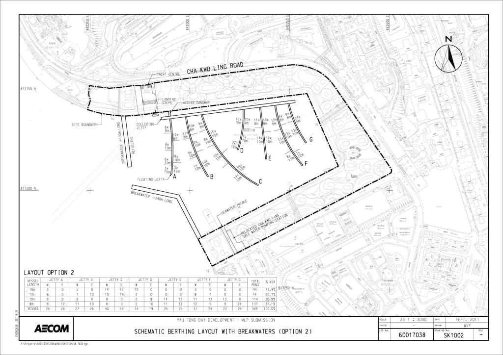
77
78
79

80
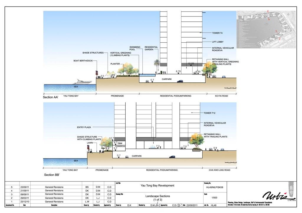
81

82

83

84
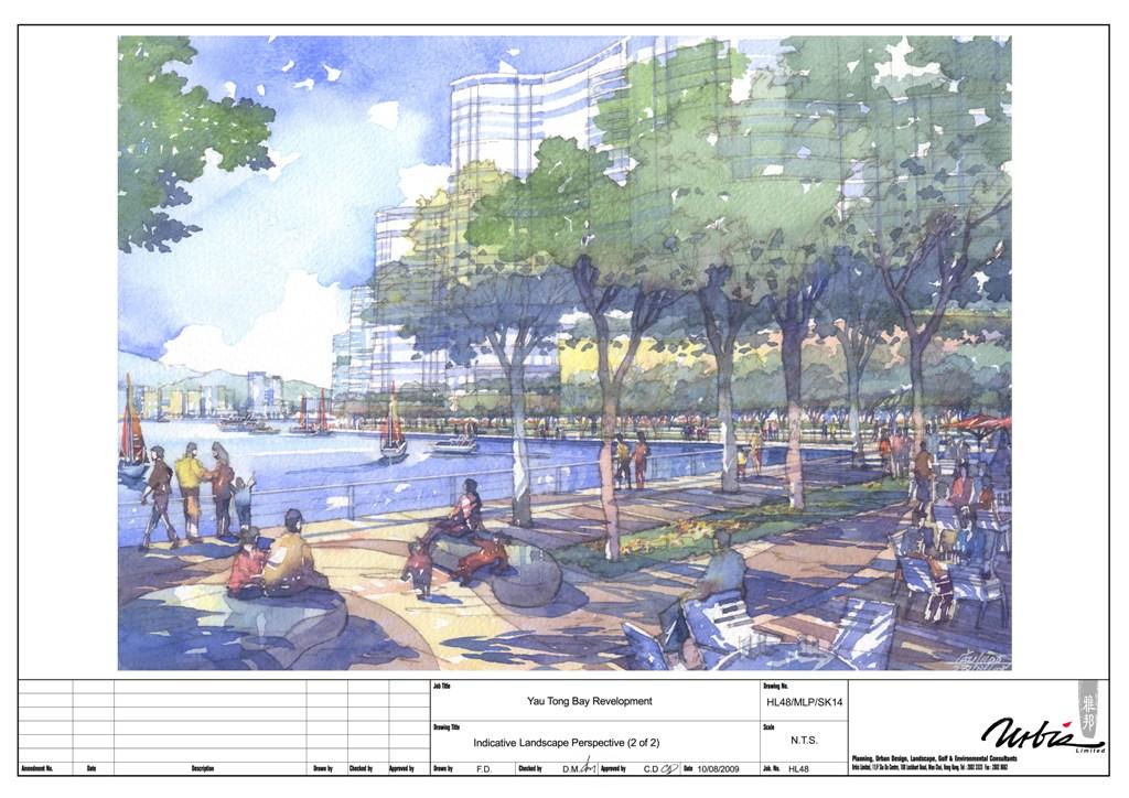
85

86

87

88
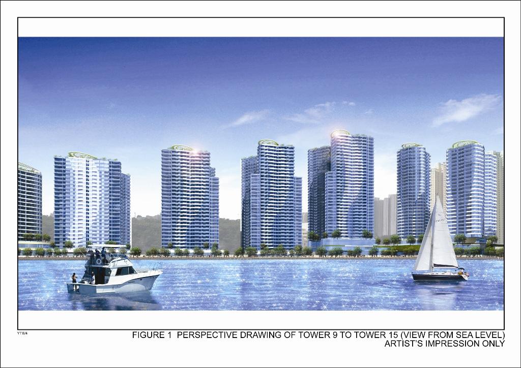
89
Task Force on Kai Tak Harbourfront Development
 Task Force on Kai Tak Harbourfront Development For discussion on 1 September 2014 TFKT/08/2014 Kai Tak Development Proposal of Increasing Development Intensity and Findings of Technical Study PURPOSE This
Task Force on Harbourfront Developments in Kowloon, Tsuen Wan and Kwai Tsing
 Task Force on Harbourfront Developments in Kowloon, Tsuen Wan and Kwai Tsing For discussion on 2 June 2016 TFK/03/2016 AMENDMENTS TO THE APPROVED TSUEN WAN OUTLINE ZONING PLAN NO. S/TW/31 PURPOSE This
Overview of Land Use Framework for Victoria Harbourfront. Planning Department February 2011
 Overview of Land Use Framework for Victoria Harbourfront Planning Department February 2011 Background TPB set out Vision Statement for the Victoria Harbour in 1999 To make Victoria Harbour attractive,
Task Force on Harbourfront Developments on Hong Kong Island
 Task Force on Harbourfront Developments on Hong Kong Island For discussion on 10 May 2012 TFHK/04/2012 Proposed Composite Hotel, Residential and Public Open Space Development In Comprehensive Development
Sub-committee on Harbour Plan Review of Harbour-front Enhancement Committee. Ninth Meeting
 Sub-committee on Harbour Plan Review of Harbour-front Enhancement Committee Ninth Meeting Date: 5 October 2005 Time: 3:30pm Venue: Conference Room 15/F, North Point Government Offices, 333 Java Road, North
Task Force on Kai Tak Harbourfront Development
 Task Force on Kai Tak Harbourfront Development For discussion on 29 March 2018 TFKT/04/2018 Study of Kai Tak Promenade Design Control and Guidelines Conceptual design scheme for Promenade at Runway Precinct
Task Force on Water-land Interface
 Task Force on Water-land Interface For discussion on 2 June 2016 TFWL/02/2016 An Overview of Railing Design along Victoria Harbourfront PURPOSE This paper gives Members an overview of the design of existing
Task Force on Kai Tak Harbourfront Development. Station Square at Kai Tak
 For discussion on 24 February 2017 Station Square at Kai Tak PURPOSE This paper seeks Members views on the design of the Station Square at Kai Tak. BACKGROUND 2. Upon the relocation of the Hong Kong International
Harbour-front Enhancement Committee. Urban Design Study for the New Central Harbourfront Revised Planning and Urban Design Concepts
 Harbour-front Enhancement Committee Paper No. 5/2010 For discussion on 18 February 2010 Urban Design Study for the New Central Harbourfront Revised Planning and Urban Design Concepts Purpose 1. This Paper
Kai Tak Development Proposal of Increasing Development Intensity and Findings of Technical Study. PlanD CEDD GPA IRD ArchSD
 Kai Tak Development Proposal of Increasing Development Intensity and Findings of Technical Study PlanD CEDD GPA IRD ArchSD Overview of Kai Tak Former North Apron Kai Tak Land Use Plan Kowloon Bay To Kwa
HBF Marine Study: Victoria Harbour: Water dependent and water related uses and associated land/water interface implications
 HBF Marine Study: Victoria Harbour: Water dependent and water related uses and associated land/water interface implications Presentation on the Initial Findings 9 February 2011 Harbour Business Forum Background
Task Force on Harbourfront Developments on Hong Kong Island. Hong Kong Island East Harbour-front Study
 For discussion on 30 August 2011 Hong Kong Island East Harbour-front Study PURPOSE The purpose of this paper is to seek Members views on the recommended enhancement proposals formulated under the Hong
Harbour-front Enhancement Committee Sub-committee on Harbour Plan Review
 Paper No.13/2009 For discussion on 22 July 2009 Harbour-front Enhancement Committee Sub-committee on Harbour Plan Review Draft Planning Brief for Comprehensive Development Area (1) Site at the Guangzhou
Task Force on Harbourfront Developments on Hong Kong Island
 Task Force on Harbourfront Developments on Hong Kong Island For discussion TFHK/10/2016 On 25 May 2016 PURPOSE This paper seeks Members views on the reprovisioning of Tin Chiu Street Playground (TCSP)
Harbour-front Enhancement Committee. Wan Chai Development Phase II. Planning and Engineering Review
 Paper No. 4/2004 For discussion on 6 May 2004 Harbour-front Enhancement Committee Wan Chai Development Phase II Planning and Engineering Review PURPOSE This paper briefs Members on the scope, approach,
Chapter 2: OUTLINE PLANNING APPLICATION PROPOSALS. A New Garden Neighbourhood Matford Barton 17
 Chapter 2: OUTLINE PLANNING APPLICATION PROPOSALS A New Garden Neighbourhood Matford Barton 17 2.1. SUMMARY AND STATUS OF THE PROPOSALS 2.1.1. The parameter plans and associated wording in this chapter
[PLANNING RATIONALE] For Site Plan Control and Lifting of Holding Zone By-Law 101 Champagne Avenue. May 23, 2014
![[PLANNING RATIONALE] For Site Plan Control and Lifting of Holding Zone By-Law 101 Champagne Avenue. May 23, 2014](/thumbs/75/71599615.jpg "[PLANNING RATIONALE] For Site Plan Control and Lifting of Holding Zone By-Law 101 Champagne Avenue. May 23, 2014") [PLANNING RATIONALE] For Site Plan Control and Lifting of Holding Zone By-Law 101 Champagne Avenue May 23, 2014 Contents 1.0 Introduction... 2 2.0 Site Context... 2 2.1 Adjacent Uses... 2 Figure 1: Site
[PLANNING RATIONALE] For Site Plan Control and Lifting of Holding Zone By-Law 101 Champagne Avenue May 23, 2014 Contents 1.0 Introduction... 2 2.0 Site Context... 2 2.1 Adjacent Uses... 2 Figure 1: Site
4 RESIDENTIAL ZONE. 4.1 Background
 4 RESIDENTIAL ZONE 4.1 Background The residential areas within the City are characterised by mainly lowrise dwellings sited on individual allotments. Past architectural styles, settlement patterns and
Task Force on Kai Tak Harbourfront Development. Update on Implementation of Public Creatives in Kai Tak Development
 Task Force on Kai Tak Harbourfront Development For information on 24 February 2017 TFKT/05/2017 Update on Implementation of Public Creatives in Kai Tak Development PURPOSE This paper updates Members on
Page 1 of 19 URBAN DESIGN FRAMEWORK FOR BOLTON STREET WATERFORD
 Page 1 of 19 URBAN DESIGN FRAMEWORK FOR BOLTON STREET WATERFORD 1.0 Introduction: The relocation of the City Council stores and depot from Bolton Street creates an exciting opportunity for development
Preliminary Land Use Proposal for the Western Part of Kennedy Town Task Force on Harbourfront Developments on Hong Kong Island
 Preliminary Land Use Proposal for the Western Part of Kennedy Town Task Force on Harbourfront Developments on Hong Kong Island 2013.6.7 Planning Department Review Area Review Area WIL s works area Bus
3 Summary of Major Views and Responses
 3 Summary of Major Views and Responses 3.1 Major Views 3.1.1 The comments and suggestions received from various channels and parties during the two-month Stage 1 PE on the Study, which have been discussed
Task Force on Harbourfront Developments in Kowloon, Tsuen Wan and Kwai Tsing. Renovation of the Hong Kong Museum of Art
 For discussion on 16 May 2013 Renovation of the Hong Kong Museum of Art I. PURPOSE This paper seeks Members comments on and support for the renovation plan for the Hong Kong Museum of Art (HKMA), which
Schedule of Planning Applications Committee Date: 23 May Reference: 06/17/0726/F Parish: Hemsby Officer: Mr J Beck Expiry Date:
 Schedule of Planning Applications Committee Date: 23 May 2018 Reference: 06/17/0726/F Parish: Hemsby Officer: Mr J Beck Expiry Date: 22-05-2018 Applicant: Proposal: Site: Mr Gillett Change of use to the
Official Plan Review: Draft Built Form Policies
 PG.30.1 REPORT FOR ACTION Official Plan Review: Draft Built Form Policies Date: May 15, 2018 To: Planning and Growth Management Committee From: Chief Planner and Executive Director, City Planning Division
George Hotel application STAFF REVIEW COMMITTEE OF THE WHOLE JANUARY 14, 2014
 George Hotel application STAFF REVIEW COMMITTEE OF THE WHOLE JANUARY 14, 2014 1 Presentation outline Purpose: to seek Council direction for next steps in the review process Application process to date
Mark-up of the effect of the proposed Bronte Village Growth Area OPA No.18 on the text of section 24, Bronte Village, of the Livable Oakville Plan
 Mark-up of the effect of the proposed Bronte Village Growth Area OPA No.18 on the text of section 24, Bronte Village, of the Livable Oakville Plan Notes: This document is provided for information purposes
The Proposed Auckland Unitary Plan (notified 30 September 2013)
") 3 Business zones Introduction There are 10 business zones in the Unitary Plan: City Centre Metropolitan Centre Town Centre Local Centre Neighbourhood Centre Mixed Use General Business Business Park Light
3 Business zones Introduction There are 10 business zones in the Unitary Plan: City Centre Metropolitan Centre Town Centre Local Centre Neighbourhood Centre Mixed Use General Business Business Park Light
Urban Design Manual PLANNING AROUND RAPID TRANSIT STATIONS (PARTS) Introduction. Station Study Areas
 Introduction. Station Study Areas") 111111 PLANNING AROUND RAPID TRANSIT STATIONS (PARTS) Introduction The ION rapid transit system will link Waterloo, Kitchener and Cambridge through a central transit corridor (CTC). There are a number
111111 PLANNING AROUND RAPID TRANSIT STATIONS (PARTS) Introduction The ION rapid transit system will link Waterloo, Kitchener and Cambridge through a central transit corridor (CTC). There are a number
Derry City and Strabane District Council Planning Committee Report
 Derry City and Strabane District Council Planning Committee Report COMMITTEE DATE: 23 rd March 2016 APPLICATION No: APPLICATION TYPE: PROPOSAL: LOCATION: APPLICANT: LA11/2015/0395/F Residential Development
Colchester Northern Gateway Master Plan Vision Review Draft. July 2016
 Colchester Northern Gateway Master Plan Vision Review Draft July 2016 Contents Introduction 4 Context 8 Purpose of the Report 8 Strategic Position 9 Overview of the Process 11 2012 Master Plan Vision 12
Place Brief. National Collections Facility (NCF site)
") Place Brief. National Collections Facility (NCF site) Contents 1.0 Purpose 2.0 Location and Proposal 3.0 Vision and Aim 4.0 Placemaking Principles 5.0 Conclusion Plan 1 Location Plan Plan 2 Placemaking
Place Brief. National Collections Facility (NCF site) Contents 1.0 Purpose 2.0 Location and Proposal 3.0 Vision and Aim 4.0 Placemaking Principles 5.0 Conclusion Plan 1 Location Plan Plan 2 Placemaking
Design Guidance. Introduction, Approach and Design Principles. Mauritius. November Ministry of Housing and Lands. .. a
 sig evelo r D Mauritius s. Utilities.. Individu a s. er itects.to ls chpers.po e Public. T. h rban D Sc U e me Promot e h ners. A Design Guidance o.h Planne rs n w iticians r l useholde National Development
I615. Westgate Precinct
 I615. Westgate Precinct I615.1. Precinct Description The Westgate Precinct is located approximately 18km west of the Auckland city centre. There are seven Sub-precincts in the Westgate Precinct: Sub-precinct
Sustainability Statement. Whitby Business Park Area Action Plan
 Sustainability Statement Whitby Business Park Area Action Plan November 2014 Contents Page 1. Introduction 1 2. Scoping 3 3. Sustainability Appraisal of Options 6 4. Assessment of Draft Area Action Plan
FORMER CANADIAN FORCES BASE (CFB) ROCKCLIFFE SECONDARY PLAN. Official Plan Amendment XX to the Official Plan for the City of Ottawa
 ROCKCLIFFE SECONDARY PLAN. Official Plan Amendment XX to the Official Plan for the City of Ottawa") FORMER CANADIAN FORCES BASE (CFB) ROCKCLIFFE SECONDARY PLAN Official Plan Amendment XX to the Official Plan for the City of Ottawa 1 INDEX THE STATEMENT OF COMPONENTS PART A THE PREAMBLE PAGE Purpose...
FORMER CANADIAN FORCES BASE (CFB) ROCKCLIFFE SECONDARY PLAN Official Plan Amendment XX to the Official Plan for the City of Ottawa 1 INDEX THE STATEMENT OF COMPONENTS PART A THE PREAMBLE PAGE Purpose...
GREENFORD HALL & ADJOINING LAND
 GREENFORD HALL & ADJOINING LAND CONTENTS 1. Introduction 1. Introduction 2. Urban Context 2.1 The Site and Surroundings 2.2 Urban Context Map 2.3 Access and Movement 3. Planning Context 3.1 Planning History
Chairman and Members of the Planning and Development Committee. Thomas S. Mokrzycki, Commissioner of Planning and Building
 LA.09.TOR (Toronto) DATE: TO: FROM: SUBJECT: Chairman and Members of the Planning and Development Committee Thomas S. Mokrzycki, Commissioner of Planning and Building Central Waterfront Secondary Plan
TALL BUILDING GUIDELINES
 TALL BUILDING GUIDELINES Urban Design Guidance for the Site Planning and Design of Tall Buildings in Milton May, 2018 A Place of Possibility Contents 1.0 INTRODUCTION 1 1.1 What is a Tall Building? 2
WHITELEY TOWN COUNCIL NORTH WHITELEY DEVELOPMENT SEPTEMBER 2014
 WHITELEY TOWN COUNCIL NORTH WHITELEY DEVELOPMENT SEPTEMBER 2014 Dear Resident This Special Edition of the Whiteley Voice which has been prepared in conjunction with the North Whiteley Consortium is to
PORT WHITBY COMMUNITY
 PORT WHITBY COMMUNITY SECONDARY PLAN UPDATE COMMUNITY IMPROVEMENT PLAN URBAN DESIGN GUIDELINES September 2015 DRAFT PROPOSED AMENDMENT NUMBER # to the Whitby Official Plan PURPOSE: The intent of this Amendment
ARLINGTON COUNTY, VIRGINIA
 ARLINGTON COUNTY, VIRGINIA County Board Agenda Item Meeting October 15, 2005 DATE: September 28, 2005 SUBJECT: Request to Advertise the adoption of the 2005 Clarendon Sector Plan C. M. RECOMMENDATION:
Description Details submitted pursuant to discharge of condition 5 (Design Code) attached to planning permission 13/01729/OUT.
 attached to planning permission 13/01729/OUT.") ITEM 9 Application Number: 18/00266/DISCON Description Details submitted pursuant to discharge of condition 5 (Design Code) attached to planning permission 13/01729/OUT. AT The Point, 602 Midsummer Boulevard,
ITEM 9 Application Number: 18/00266/DISCON Description Details submitted pursuant to discharge of condition 5 (Design Code) attached to planning permission 13/01729/OUT. AT The Point, 602 Midsummer Boulevard,
1. Welcome. Background
 1. Welcome The purpose of this exhibition is to provide you with an update on progress on the Kilnwood Vale Scheme. In order to improve the scheme and deliver key facilities earlier in the development,
Highland Village Green Design Guidelines
 Highland Village Green Design Guidelines Publishing Information Title Highland Village Green Design Guidelins Author The City of Calgary Status DRAFT - Proposed document subject to changes Additional Copies
PLANNING POLICY GUIDANCE 5
 Mauritius PLANNING POLICY GUIDANCE 5 Port Louis Pailles Reduit Triangle Ebene / Trianon Phoenix / Sodnac La Vigie Rose Belle Development along Motorway April 2008 Ministry of Housing and Lands Development
Welcome. Land adjacent Sandy Lane WALTHAM CHASE THE PROPOSED SITE
 Land adjacent Sandy Lane WALTHAM CHASE Existing Linden Homes developments Welcome Welcome to Linden Homes Southern s ( Linden ) public exhibition about its proposals for a range of high-quality homes for
Welcome. Walk Around. Talk to Us. Write Down Your Comments
 Welcome This is an information meeting introducing the applications for proposed redevelopment of the Yorkdale Shopping Centre site at 3401 Dufferin Street and 1 Yorkdale Road over the next 20+ years,
2.0 Strategic Context 4
 2.0 Strategic Context 4 2.1 The Area Action Plan is a non-statutory plan, which forms a corporate policy document, expressing particular issues and areas of concern while also providing a vision for the
Welcome. Community Consultation Meeting November 28, Review and discuss the Bathurst Quay Neighbourhood Plan Framework
 Welcome Community Consultation Meeting November 28, 2016 Why Are We Here Today? Review and discuss the Bathurst Quay Neighbourhood Plan Framework Review and discuss an Action Plan for Implementation Next
Edward R. Sajecki Commissioner of Planning and Building
 Corporate Report Clerk s Files Originator s Files CD.03.POR DATE: TO: FROM: SUBJECT: Chair and Members of Planning and Development Committee Meeting Date: February 27, 2012 Edward R. Sajecki Commissioner
I539. Smales 2 Precinct
 I539. Smales 2 Precinct I539.1. Precinct Description The Smales 2 Precinct applies to a 4.8 hectare block of land located on the southern side of Northcote Road and fronting Lake Pupuke, Takapuna. The
141 GEORGE STREET PLANNING RATIONALE
 141 GEORGE STREET PLANNING RATIONALE MINOR ZONING BY-LAW AMENDMENT NOVEMBER 2, 2016 PLANNING RATIONALE 223 McLeod Street Ottawa, ON K2P 0Z8 613.730.5709 fotenn.com INTRODUCTION FOTENN Consultants is acting
Wide asphalt driveway abutting school property. garage built with incompatible materials, too close to park. incompatible fencing materials
 Wide asphalt driveway abutting school property incompatible fencing materials garage built with incompatible materials, too close to park Lack of plantings as a buffer between private property and open
Contact: Alex Taranu ( ) or Karl Walsh ( )
 or Karl Walsh ( )") Date: 09 September 2005 File: Subject: P03.DUDS Downtown Urban Design Vision Study Report Contact: Alex Taranu (905 874 3454) or Karl Walsh (905 874 2331) OVERVIEW Staff has produced an Urban Design Vision
Date: 09 September 2005 File: Subject: P03.DUDS Downtown Urban Design Vision Study Report Contact: Alex Taranu (905 874 3454) or Karl Walsh (905 874 2331) OVERVIEW Staff has produced an Urban Design Vision
East Bayshore Road Neighbourhood
 East Bayshore Road Neighbourhood Northridge Property Management Urban Design Brief 3195 East Bayshore Road City of Owen Sound January 2016 East Bayshore Road Neighbourhood Northridge Property Management
Section Three, Appendix 17C Multiple Unit Housing Design Assessment Criteria
 APPENDIX 17C MULTIPLE UNIT HOUSING DESIGN ASSESSMENT CRITERIA Purpose of Appendix 17C In the Residential 9 Zone the construction and use of multiple household units located within the Multiple Household
Policies and Code Intent Sections Related to Town Center
 Policies and Code Intent Sections Related to Town Center The Town Center Vision is scattered throughout the Comprehensive Plan, development code and the 1994 Town Center Plan. What follows are sections
CONTENTS 8.0 LAND USE 8.1 GENERAL LAND USE 8.2 RESIDENTIAL 8.3 MIXED USE 8.4 COMMERCIAL 8.5 EMPLOYMENT LANDS
 8-2 Land Use 8.0 LAND USE CONTENTS 8.1 GENERAL LAND USE 8.1.1 Uses provided for in all Land Use Designations 8.1.2 Uses prohibited in Hazardous Lands, Hazardous Sites and Special Policy Areas 8.1.3 Uses
New-Cast Mixed-use Development Proposal King Street West, Newcastle, Ontario
 URBAN DESIGN BRIEF New-Cast Mixed-use Development Proposal King Street West, Newcastle, Ontario TABLE OF CONTENTS: 1.0 Executive Summary 2.0 Creating Vibrant and Sustainable Urban Places: Excerpts from
6 Site Framework Strategies
 6 Site Framework Strategies 6.1 Introduction Section 6 identifies a number of specific areas which are considered to be key sites within the Plan area and which may have potential for development / redevelopment.
Draft Eastern District Plan
 Draft Eastern District Plan Submission_id: 31238 Date of Lodgment: 13 Dec 2017 Origin of Submission: Online Organisation name: Turrulla Gardens Pty Ltd C/- Mecone Organisation type: Industry First name:
Regency Developments. Urban Design Brief. Holyrood DC2 Rezoning
 Regency Developments Urban Design Brief Holyrood DC2 Rezoning Stantec Consulting Ltd. 7-31-2017 1. Overview Regency Developments intends to rezone the lands located at 8510 and 8511 93 Avenue, within the
Former Temple Cowley Pools, Oxford TEMPLE COWLEY LIBRARY * ELEVATION SHOWN IS INDICATIVE AND SUBJECT TO FINAL DESIGN AND AGREEMENT.
 OPEN SPACE TEMPLE COWLEY LIBRARY library beyond Proposed apartments Proposed apartments Proposed houses Temple Road * ELEVATION SHOWN IS INDICATIVE AND SUBJECT TO FINAL DESIGN AND AGREEMENT. * Welcome
Housing Development at Balloonagh Tralee Co Kerry
 Design Statement Housing Development at Balloonagh Tralee Co Kerry Area of site 10,400m2 24 houses-12no 3 bed, 12no 2 bed and 4 single bed apartments total residential area of 2411m2 Open space provided
Westwind Developments Ltd. PIONEER LANDS AREA STRUCTURE PLAN - PROPOSED AMENDMENT
 FEBRUARY 2013 TABLE OF CONTENTS 1.0 BACKGROUND... 1 1.1 Amendment... 1 2.0 LOCATION & CONTEXT... 2 2.1 Land Ownership... 2 3.0 POLICY CONTEXT... 3 3.1 Municipal Development Plan... 3 3.2 Capital Region
URBAN DESIGN STUDY FOR THE WAN CHAI NORTH AND NORTH POINT HARBOURFRONT AREAS FEASIBILITY STUDY
 Agreement No. CE 54/2014 (TP) Meeting with Task Force on Harbourfront Developments on HK Island 10 Feb 2015 2 CONTENTS STUDY TEAM STUDY METHODOLOGY & APPROACH STUDY PROGRAMME KEY ISSUES Study Team Organization
ELMVALE ACRES SHOPPING CENTRE MASTER PLAN
 ELMVALE ACRES SHOPPING CENTRE MASTER PLAN Contents 1.0 INTRODUCTION... 2 2.0 LOCATION... 2 3.0 EXISTING CONTEXT... 2 4.0 VISION & GUIDING PRINCIPLES... 2 5.0 LAND USE AND BUILT FORM... 4 5.1 St. Laurent
Chapter 13 Residential Areas: Appendices APPENDIX 1 Residential Areas
 Chapter 13 Residential Areas: Appendices Page 1 Chapter 13 Residential Areas: Appendices APPENDIX 1 Residential Areas Design Code for Intensive Housing INTRODUCTION DESIGN ELEMENTS A NEIGHBOURHOOD DESIGN
Complete Neighbourhood Guidelines Review Tool
 Complete Neighbourhood Guidelines Review Tool Prepared By: City of Regina Planning Department October 2014 Page 1 of 14 Community Development Review Checklist for Secondary Plans and Concept Plans The
5 TOWN OF MARKHAM OFFICIAL PLAN AMENDMENT NO. 144 MILLIKEN MAIN STREET SECONDARY PLAN
 5 TOWN OF MARKHAM OFFICIAL PLAN AMENDMENT NO. 144 MILLIKEN MAIN STREET SECONDARY PLAN The Planning and Economic Development Committee recommends the following: 1. The communication from Brendan O Callaghan,
HARBOUR-FRONT ENHANCEMENT REVIEW WAN CHAI, CAUSEWAY BAY & ADJOINING AREAS REALIZATION STAGE
 HARBOUR-FRONT ENHANCEMENT REVIEW WAN CHAI, CAUSEWAY BAY & ADJOINING AREAS REALIZATION STAGE SUPPLEMENTARY DOCUMENT October 2006 MAUNSELL CONSULTANTS ASIA LTD HARBOUR-FRONT ENHANCEMENT REVIEW WAN CHAI,
REMARKABLES PARK ZONE
 .10 Remarkables Park Zone.10.1 Resources, Activities and Values The Remarkables Park Area comprises approximately 150 hectares of perimeter urban land in the vicinity of Frankton and occupies a strategic
97 Lea Bridge Road, Leyton, E10 7QL London Borough of Waltham Forest December 2015
 97 Lea Bridge Road, Leyton, E10 7QL London Borough of Waltham Forest December 2015 Public Realm and Landscape Proposals LEA BRIDGE ROAD, WALTHAMSTOW Public Realm & Landscape Proposals BDP(90)RPT001 December
(DC1) Direct Development Control Provision DC1 Area 4
 Direct Development Control Provision DC1 Area 4") . General Purpose (DC) Direct Development Control Provision DC Area 4 The purpose of this Provision is to provide for an area of commercial office employment and residential development in support of the
. General Purpose (DC) Direct Development Control Provision DC Area 4 The purpose of this Provision is to provide for an area of commercial office employment and residential development in support of the
Longbridge Town Centre Phase 2 Planning Application
 Longbridge Town Centre Phase 2 Planning Application Non-Technical Summary of the Environmental Statement December 2013 Introduction A full application for Planning Permission has been submitted to Birmingham
John M. Fleming Managing Director, Planning and City Planner. Old East Village Dundas Street Corridor Secondary Plan Draft Terms of Reference
 Report to Planning and Environment Committee To: From: Subject: Chair and Members Planning & Environment Committee John M. Fleming Managing Director, Planning and City Planner Old East Village Dundas Street
MAYFIELD WEST SECONDARY PLAN PHASE 2
 MAYFIELD WEST SECONDARY PLAN PHASE 2 Public Open House #3 February 25, 2010 Draft Preferred Land Use Scenario TOWN OF CALEDON PLANNING & DEVELOPMENT DEPARTMENT Open House Agenda TOWN OF CALEDON 1. Welcome
Welcome to the Oakridge Centre Open House
 Welcome to the Oakridge Centre Open House Why is the City hosting this event? This open house is to inform you of a rezoning application submitted to the City of Vancouver to amend the existing CD-1 (Comprehensive
Contents of Part 6. Part 6 Zones
 Contents of Part 6 Part 6 Zones... 6-1 6.1 Preliminary... 6-1 6.2 Zone codes... 6-3 6.2.1 Low density residential zone code... 6-3 6.2.1.1 Application... 6-3 6.2.1.2 Purpose and overall outcomes... 6-3
Community Design Plan
 Gardena General Plan 2006 Authority While the is not a required element of a General Plan, it is included because improving the community appearance and image is paramount to the overall quality of life
CITY CLERK. Parkland Acquisition Strategic Directions Report (All Wards)
") CITY CLERK Clause embodied in Report No. 10 of the, as adopted by the Council of the City of Toronto at its meeting held on November 6, 7 and 8, 2001. 10 Parkland Acquisition Strategic Directions Report
CITY CLERK Clause embodied in Report No. 10 of the, as adopted by the Council of the City of Toronto at its meeting held on November 6, 7 and 8, 2001. 10 Parkland Acquisition Strategic Directions Report
City Center Neighborhood Plan
 [1] City Center Neighborhood Plan As adopted by Ordinance No. 2014-09-049 and amended by Ordinance Nos. Formerly CBD Neighborhood as adopted by Ordinance No. 8868 and amended by Ordinance Nos. 8946, 9693,
Courthouse Square Planning & Urban Design Study. Courthouse Square Working Group #13 October 15, 2014
 Courthouse Square Planning & Urban Design Study Courthouse Square Working Group #13 October 15, 2014 1 Courthouse Square Process Working Group Community Courthouse Square Advisory Groups & Civic Associations
280 Manse Road - Official Plan Amendment, Zoning Amendment, Draft Plan of Subdivision Applications - Preliminary Report
 STAFF REPORT ACTION REQUIRED 280 Manse Road - Official Plan Amendment, Zoning Amendment, Draft Plan of Subdivision Applications - Preliminary Report Date: March 11, 2014 To: From: Wards: Reference Number:
CENTRAL HARBOURFRONT AND ME (CHarM) DESIGN BRIEF
 DESIGN BRIEF") CENTRAL HARBOURFRONT AND ME (CHarM) DESIGN BRIEF March 2006 Design Brief for the Central Ferry Piers and Adjoining Areas Enhancement PURPOSE OF THE BRIEF 1. The Central Ferry Pier and adjoining areas (named
CENTRAL HARBOURFRONT AND ME (CHarM) DESIGN BRIEF March 2006 Design Brief for the Central Ferry Piers and Adjoining Areas Enhancement PURPOSE OF THE BRIEF 1. The Central Ferry Pier and adjoining areas (named
Figure 1- Site Plan Concept
 Figure 1- Site Plan Concept Parking will be provided underground on three levels at rate of 1.0 space/ unit; this rate includes all visitors parking. MMM Group has prepared a parking assessment (April,
MAYFIELD WEST SECONDARY PLAN PHASE 2
 MAYFIELD WEST SECONDARY PLAN PHASE 2 Council Information Workshop February 16, 2010 Draft Preferred Land Use Plan TOWN OF CALEDON PLANNING & DEVELOPMENT DEPARTMENT Workshop Agenda TOWN OF CALEDON 1. Welcome
5 PLANNING ANALYSIS 5.1 THE SITE AND ITS DEVELOPMENT CONTEXT
 5 PLANNING ANALYSIS 5.1 THE SITE AND ITS DEVELOPMENT CONTEXT The Azuri IRS River Villa Complex site is situated on the western margin of Azuri Phase 1, inland. The whole site borders Rivière du Rempart
DRAFT Northeast Quadrant of Kipling Avenue and Highway 7 DRAFT AUGUST 29, Goals Land Use. The goals of this Plan are to:
 AUGUST 29, 2017 12.15 Northeast Quadrant of Kipling Avenue and Highway 7 12.15.1 Goals 12.15.2 Land Use The goals of this Plan are to: 12.15.2.1 General Provisions: a) Ensure the development of a compact
URBAN DESIGN BRIEF New Street Burlington, ON
 3225-3237 New Street Burlington, ON MARCH 2017 Prepared for: Royal Living Development Group Inc. Prepared by: adesso design inc. 218 Locke Street South, 2nd Floor Hamilton, ON L8P 4B4 t. 905.526.8876 3225-3237
Welcome to our exhibition
 Welcome to our exhibition housing development A46 Wildmoor Alcester Road Canal Quarter A422 Town Centre housing development Warwickshire-based IM Properties, one of the UK s largest privately owned property
Planning and Growth Management Committee. Chief Planner and Executive Director, City Planning Division. Pg12013 (File No NNY 34 OZ)
") 865 York Mills Road Official Plan Amendment Application Preliminary Report STAFF REPORT ACTION REQUIRED Date: February 28, 2012 To: From: Wards: Reference Number: Planning and Growth Management Committee
865 York Mills Road Official Plan Amendment Application Preliminary Report STAFF REPORT ACTION REQUIRED Date: February 28, 2012 To: From: Wards: Reference Number: Planning and Growth Management Committee
medium desnity housing
 This section updated September 2013 This part of the Plan sets out the assessment criteria for medium density housing. The criteria are designed to give designers and builders flexibility and to provide
YONGE STEELES CORRIDOR SECONDARY PLAN. Young + Wright / IBI Group Architects Dillon Consulting Ltd. GHK International (Canada) Ltd.
 Ltd.") PART A: PREAMBLE 1.0 PURPOSE The purpose of this Secondary Plan is to provide a development framework for intensification of the Yonge/ Steeles corridor including the north side of Steeles Avenue West
PART A: PREAMBLE 1.0 PURPOSE The purpose of this Secondary Plan is to provide a development framework for intensification of the Yonge/ Steeles corridor including the north side of Steeles Avenue West
Newcourt Masterplan. November Exeter Local Development Framework
 Newcourt Masterplan November 2010 Exeter Local Development Framework Background The Exeter Core Strategy Proposed Submission sets out the vision, objectives and strategy for the development of Exeter up
Town of Cobourg Heritage Master Plan. Statutory Public Meeting
 Town of Cobourg Heritage Master Plan Statutory Public Meeting April 25 th 2016 Presentation Overview 1. Introduction 2. Project background and schedule overview 3. Review of strategic direction content
10 Proposed Redevelopment, Tewkesbury Road, Cheltenham SCHEME EVOLUTION STARBUCKS
 SCHEME EVOLUTION STARBUCKS The proposed Starbucks Drive Thru alongside the proposed food store provides an appropriate mix of uses, suitable for this location. The proposed store is bespoke, designed specifically
Municipal Development Plan Update Urban Service Area and Hamlets
 ENCLOSURE 1 Municipal Development Plan Update Urban Service Area and Hamlets Priorities Committee January 24, 2017 MUNICIPAL DEVELOPMENT PLAN UPDATE SHAPING OUR FUTURE MDP Update - Agenda MDP Update Public
PLANNING ADVISORY BOARD AGENDA OCTOBER
 ! City of Langley PLANNING ADVISORY BOARD AGENDA OCTOBER 1, 2014 3-5pm LANGLEY CITY HALL - 112 2 nd Street, Langley WA 1) Call to Order and Roll Call 2) Approval of the Minutes September 10, 2014 3) Public