CITY OF COLUMBIA AGENDA MEMORANDUM
|
|
|
- Leslie Pierce
- 5 years ago
- Views:
Transcription
 to C-1 (Office and Institutional District) Krista Hampton see case summary ATTACHMENTS:")
1 CITY OF COLUMBIA AGENDA MEMORANDUM MEETING DATE: September 15, 2015 DEPARTMENT: FROM: SUBJECT: PRESENTER: FINANCIAL IMPACT: Planning and Development Services Krista Hampton, Director 1319 Caroline Road, TMS# , Rezone from UTD (Urban Transitional District) to C-1 (Office and Institutional District) Krista Hampton see case summary ATTACHMENTS: ZPH_ _MA_1319_Caroline_Rd_Case_Summary (PDF) Updated: 8/26/2015 5:16 PM Page 1
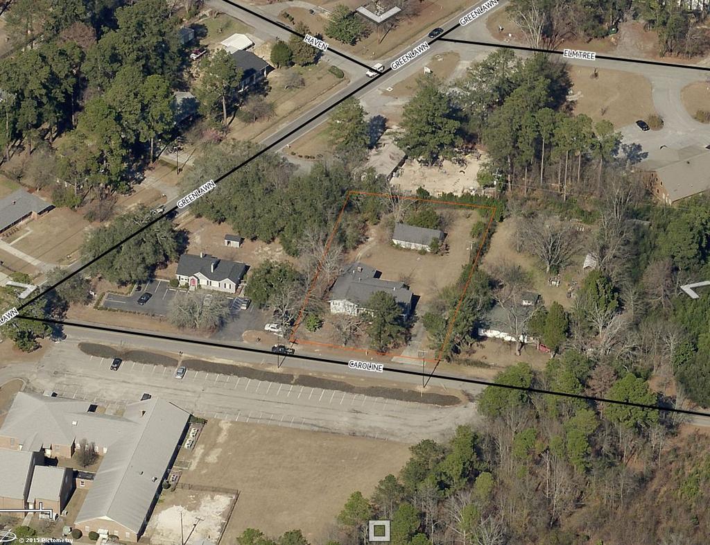
2 CITY COUNCIL ZONING MAP AMENDMENT CASE SUMMARY REZONE FROM UTD (URBAN TRANSITIONAL DISTRICT) TO C-1 (OFFICE AND INSTITUTIONAL DISTRICT) 1319 CAROLINE ROAD Zoning Public Hearing September 15, 2015 at 7:00 pm City Council Chambers, 3 rd Floor, 1737 Main Street, Columbia, SC Subject Property: 1319 Caroline Road, TMS# Council District: 3 Proposal: Rezone parcel from UTD to C-1 Applicant: Donald J. Simons Present Use: Residential Proposed Use: Unknown Staff Recommendation: Deny PC Recommendation: Deny (5-0), 05/04/15 CASE HISTORY Planning Commission 05/04/15 UTD to C-1 DENY Zoning Public Hearing 07/21/15 UTD to C-1 DEFERRED Zoning Public Hearing 09/15/15 UTD to C-1 PENDING The proposal is to rezone a UTD zoned parcel to C-1. APPLICATION REQUEST CURRENT PARCEL CHARACTERISTICS/CONDITIONS Currently, the total acreage of the parcel is.65 acres and is located directly east of Greenlawn Memorial Park. PLANS, POLICIES, AND LAND USE The Columbia Plan 2018: Comprehensive Plan Land Use Classification Subject parcel is designated Urban Edge Residential Small Lot (UER-1) in The Columbia Plan 2018 Future Land Use Map. 1
3 Urban Edge Residential Small Lot neighborhoods account for a significant portion of the city s existing residential neighborhoods. This development type is appropriate as development on remaining large lots or as redevelopment in the outer areas of Columbia. Most of these developments are relatively modern and occurred after Urban Edge Residential Small Lot developments generally do not continue the grid and block pattern found in the urban core neighborhoods, but do tend to have a consistently organized internal street network with loops and interconnections. Cul-de-sacs are most prominent in this development type. Building Types and Land Uses include: Primary Types: Single-family detached Tertiary Types: Single-family attached Two-family Three-family Multi-family small Small format business/employment Small format civic/institutional Cemeteries & mausoleums PROPOSED ZONING DISTRICT SUMMARY The parcel is currently zoned UTD (Urban Transitional District). The adjacent lots are UTD, RS-1 and C-3 in the City of Columbia. The C-1 district is intended to accommodate office, institutional, and certain types of residential uses in areas whose characteristic is neither general commercial nor exclusively residential in nature. Certain related structures and uses required to serve the needs of the areas are permitted outright or are permissible as special exceptions subject to restrictions and requirements intended to best fulfill the intent of this article. STAFF RECOMMENDATION Staff recommends denial. C-1 zoning could potentially introduce large format commercial or residential uses that are not recommended in the UER-1 land use classification. Additionally, expansion of C-1 zoning in the area would further reduce the buffer provided by the UTD zoning district between the commercial zoned areas and adjacent residential areas. 2
4 Table of Permitted Uses Table of Permitted Uses UTD C-1 Permitted Principal Uses Permitted Principal Uses Landscape counseling and planning Mining and quarrying of nonmetallic minerals, except fuel Arrangement of Transportation Services Communication services, not elsewhere classified Water supply services Landscape counseling and planning Building Construction - Office Only Construction other than building construction - Office Only Arrangement of Transportation Services Water supply services Sewerage Systems (Sec ) Sewerage Systems (Sec ) Finance, Insurance, and Real Estate Cemetery subdividers and developers Photographic Studies, portrait Finance, Insurance, and Real Estate Organization hotels and lodging houses on membership basis Cemetery subdividers and developers Beauty Shops Barbershops Shoe repair shops, shoeshine parlors, and hat cleaning shops Funeral Service and crematories Photographic Studies, portrait Funeral Service and crematories Advertising agencies Consumer credit reporting agencies Advertising agencies Blueprinting and photocopying (Sec ) Blueprinting and photocopying (Sec ) Commercial photography, art and graphics Employment agencies Computer and data processing services Watch and jewelry repair Dance studios Municipal or other passive recreation facilities (parks, greenways, including administrative facilities) Physical fitness facilities and yoga facilities Offices of physicians Medical and dental laboratories Legal services Libraries and information centers Business and secretarial schools Vocational schools except vocational high schools not elsewhere classified Individual and family social services Job training and vocational rehabilitation services Commercial photography, art and graphics Stenographic services and reproduction services not elsewhere classified Employment agencies Temporary help services Computer and data processing services Detective agencies and protective services Parking Lots Municipal or other passive recreation facilities (parks, greenways, including administrative facilities) Dance studios Public Golf Course Offices of physicians Nursing and personal care facilities Hospitals Medical and dental laboratories Legal services Colleges, universities, professional schools, and junior colleges 3
5 Museums and art galleries Arboreta, botanical and zoological gardens Business associations Professional membership Labor unions and similar organizations Civic, social and fraternal associations Libraries and information centers Business and secretarial schools Vocational schools except vocational high schools not elsewhere classified Individual and family social services Job training and vocational rehabilitation services Museums and art galleries Political organizations Religious organizations Engineering, architectural, and surveying services Accounting, auditing, and bookkeeping services Noncommercial research organization Detached One-Family Dwelling Attached Two-Family Dwelling Miscellaneous services Permitted in District, provided owner and/or tenant complies with the associated conditions set forth in this article Municipal active recreation facilities (athletic ball fields, swimming pools, playgrounds, including administration facilities )(Sec ) Non-depository personal credit institutions (pay day loan and/or title loan establishments (Sec ) Offices and clinics of other health practitioners, including therapeutic massage (17-288) Business associations Professional membership Labor unions and similar organizations Civic, social and fraternal associations Political organizations Religious organizations Engineering, architectural, and surveying services Accounting, auditing, and bookkeeping services Commercial economic, sociological, and educational research Noncommercial research organization Management and public relations services Detached One-Family Dwelling Permitted as an Accessory Use or as a Principal Use by Special Exception Attached Two-Family Dwelling Food crops grown within a covered enclosure High-Rise (Sec ) Building Construction - Office Only Mid-Rise (Sec ) Construction other than building construction - Office Only Construction-Special trade contractors - Office only General farms, primarily crop Special Exception by Board of Zoning Appeals U.S. Postal Service Electric substations Combination electric and gas, and other utility services Detective agencies and protective services Agricultural services with indoor kennels Agricultural services with outdoor kennels Miscellaneous services Executive Offices Legislative bodies General government not elsewhere classified Courts Police and Fire Protection Public finance, taxation, and monetary policy Administration of human resources programs Administration of environmental quality and housing programs Administration of economic programs 4
6 Radio and mobile telephone installation shops Day Care Facilities (Sec ) Permitted in District, provided owner and/or tenant complies with the associated conditions set forth in this article Municipal active recreation facilities (athletic ball fields, swimming pools, playgrounds, including administration facilities )(Sec ) Non-depository personal credit institutions (pay day loan and/or title loan establishments (Sec ) Offices and clinics of other health practitioners, including therapeutic massage (17-288) Elementary and Secondary Schools (17-296) Permitted Accessory Use Private Commercial Storage (Sec ) Eating Places Drugstores and proprietary stores Beauty Shops Barbershops Reupholster and furniture repair Permitted as an Accessory Use or as a Principal Use by Special Exception Food crops grown within a covered enclosure General farms, primarily crop Special Exception by Board of Zoning Appeals Veterinary services with indoor kennels Veterinary services with outdoor kennels Rooming houses and boardinghouses U.S. Postal Service Drinking Places (alcoholic beverages)(sec ) Electric substations Florist Cigar store and stands New dealers and newsstands Miscellaneous retail stores, not elsewhere classified Apparel and accessory stores Coin-operated laundries and dry cleaning Garment pressing and agents for laundries and dry cleaners Miscellaneous personal services, except massage parlors and spas Massage parlors and spas 5
7 Business services not elsewhere classified Agricultural services with indoor kennels Agricultural services with outdoor kennels Parking structures Radio and mobile telephone installation shops Watch and jewelry repair Motion picture theaters except drive-in Physical fitness facilities and yoga facilities Membership Sports and Recreation Clubs Arboreta, botanical and zoological gardens Day Care Facilities (Sec ) Residential Care (Sec ) Attached One-Family Dwelling Multi-Family Dwelling Group Development Dormitories, Public Fraternity and sorority houses 6
8

9 Future Land Use Map 1319 Caroline Road TMS# FLU: UER-1 Department of Planning & Development Services AR UN D Legend UCMR-1 - Urban Core Mixed Residential-1 UEMR - Urban Edge Mixed Residential AC-2 N SP RI NG S A ALM UEMF - Urban Edge Multi-Family H OAC DEL UCMR-2 - Urban Core Mixed Residential-2 RD E VIL LAG E GA PARCELS KI N CULPEPPER LES AR H GC KING CHARLE S CITY LIMITS EL LEESB URG UCR-1 - Urban Core Residential Small Lot UCR-2 - Urban Core Residential Large Lot UER-1 - Urban Edge Residential Small Lot UER-2 - Urban Edge Residential Large Lot UCAC-2 - Urban Core Community Activity Center HAVEN UEAC-1 Urban Edge Community Activity Center UCAC-3 Urban Core Regional Activity Center AC-1 - Neighborhood Activity Corridor IND - Industrial TU - Transportation & Utilities SD-2 ELMTR EE OR E EC - Employment Campus KE NM AC-3 - Regional Activity Corridor SD-1 - Sports/Amusement District SO N UCAC-1 AC-2 - Community Activity Corridor ER PATT UER-1 UEAC-2 - Urban Edge Regional Activity Center EUGEN E UCAC-1 - Urban Core Neighborhood Activity Center SUBJECT PARCEL SD-2 - Civic/Institutional Districts SD-4 - Riverbanks Zoo and Garden SD-5 - Universities/Colleges ASBURY SD-3 - Central Business District CAROL IN 150 WO FA IR I 300 Feet ORIGINAL PREPARATION/DATE: This map was prepared by: S. Zigmund April 28, 2015 E LA WN 75 GR EE N 0 OD SD-6 - Fort Jackson TR IN IT Y AS BU R PAT TER SO N UEMR Y AC-2 UCAC-2 UEMR UER-1 CITY OF COLUMBIA PLANNING DEPARTMENT THIS MAP IS THE PRODUCT OF COMPILATION, OR WAS PRODUCED BY OTHERS. IT IS FOR INFORMATION ONLY AND THE CITY OF COLUMBIA MAKES NO REPRESENTATIONS AS TO ITS ACCURACY OR USE WITHOUT FIELD VERIFICATION IS AT THE SOLE RISK OF THE USER. MIS S ION ** DATA SOURCE - CITY OF COLUMBIA, GIS DIVISION


10 Zoning Map 1319 Caroline Road TMS# ZONED: UTD Department of Planning & Development Services Legend PARCELS Flood Plain Overlay VILLAGE VILLAGE RG-1 VILLAGE LEESBURG D-1 C-1 RS-1 RS-1A C-2 C-3 HAVEN RS-1B C-3A RS-2 C-4 RS-3 C-5 RD M-1 RD-2 M-2 RG-1 PUD-C RG-1A RG-2 RG-3 UTD MX-1 MX-2 PUD-LS PUD-LS-E PUD-LS-R PUD-R OUT OF CITY I Feet ORIGINAL PREPARATION/DATE: This map was prepared by: S. Zigmund April 28, 2015 KENMORE FAIRWOOD RS-1 GREENLAWN UTD C-1 CAROLINE ELMTREE SUBJECT PARCEL EUGENE RG-2 RS-1 DISCLAIMER: The City of Columbia Department of Planning and Development Services data represented on this map or plan is the product of compilation, as produced by others. It is provided for informational purposes only and the City of Columbia makes no representation as to its accuracy. Its use without field verification is at the sole risk of the user. TRINITY C-3 C-3 RG-2 ** DATA SOURCE - CITY OF COLUMBIA, GIS DIVISION
KELLER WILLIAMS COMMERCIAL
 KELLER WILLIAMS COMMERCIAL BALLANTYNE AREA Uptown Land Opportunity +/- 1 acre Charlotte, NC Scott Greene 704.577.7344 scottgreene@kw.com Matthew Hagler 704.408.8867 mhagler@kwcommercial.com Scott Stevens
2.11 GC - General Commercial
 2.11 GC - General Commercial Intent - GC: s are established to provide a location for higher volume and higher intensity commercial uses than the NR District. Activities in this District are often large
LAND USE AND DEVELOPMENT REGULATIONS. 140 Attachment 3
 LAND USE AND DEVELOMENT REGULATIONS 140 Attachment 3 Schedule of ermitted and Conditional Uses for Nonresidential Zone Districts 1 [Amended 3-10-2004 by Ord. No. 3-2004; 6-23-2004 by Ord. No. 14-2004;
2.18 MU Mixed Use District.
 2.18. Intent - The is established to promote the development of an urban residential environment. The regulations are intended to encourage single family urban residential use and development while allowing
CHAPTER 20: INSTITUTIONAL USE DEVELOPMENT STANDARDS
 CHAPTER 20: INSTITUTIONAL USE DEVELOPMENT STANDARDS ARTICLE 1: GENERAL INSTITUTIONAL USE STANDARDS 320-01. Application The provisions of this Chapter shall apply to the following uses in any zone: (e)
ARTICLE XVIII C 1 CENTRAL BUSINESS DISTRICT
 ARTICLE XVIII C 1 CENTRAL BUSINESS DISTRICT SECTION 1. INTENT AND PURPOSE OF DISTRICT: The C 1 Central Business District is intended for the purpose of grouping retail merchandising activities into a concentrated
Antique shops. Aquariums. Art goods and bric-a-brac shops. Artists' studios. Auditoriums. Automobile hire.
 Sec. 62-1482. - General retail commercial, BU-1. The BU-1 general retail commercial zoning classification encompasses land devoted to general retail shopping, offices and personal services to serve the
Development Review Application Fees
 Development Review Application Fees Application Type Historic District Commission (Requires zoning sign- $10) Certificate of Approval Certification of Non-Conforming Use- Residential Use for the property
Rubber and Plastics Rubber and Plastics Leather Manufacturing Leather Manufacturing Stone, Glass, and Concrete 5 0.
 Rubber and Plastics 7 0.05 Rubber and Plastics 508 0.28 Leather Manufacturing 0 0.00 Leather Manufacturing 0 0.00 Stone, Glass, and Concrete 5 0.03 Stone, Glass, and Concrete 139 0.08 Metals Fabrication
3.5 C-I: Commercial - Industrial District
 3.5 Intent: The s are established to promote and maintain: gateway developments into the major industrial parks within the Town of Plainfield; and, the development of support facilities necessary for the
PSec MCN Mahan Corridor Node District
 PSec. 10-269 MCN Mahan Corridor Node District 1. Purpose and Intent 2. Allowable District Location The Mahan Corridor Node (MCN) zoning district is intended to implement the Mahan Gateway Node Map (FLUM)
Study Area Maps. Profile Tables. The CORE Shopping Centre Pitney Bowes 2018 Canada Business Summary
 Powered by Sitewise Page 1 Study Area Maps Profile Tables 2018 Canada Business Summary 2018 Canada Businesses By SIC Codes (1-49) 2018 Canada Businesses By SIC Codes (50-99) Prepared on: 4/20/2018 3:45:52
Price Elasticity Number Name Type. Income Elasticity. Income Elasticity
 Consumption Categories for Policy Insight v9.5 Consumption Categories for PI + v Number Name Type Income Price Number Name Type Income Price parts Necessities 0.46-0. New autos Luxuries.4 -. Net purchases
RAMHIC Eligible SIC Codes: Wholesale and Retail 5012 Automobiles and other Motor Vehicles 5013 Motor Vehicle Supplies and New Parts 5014 Tires and
 RAMHIC Eligible SIC Codes: Wholesale and Retail 5012 Automobiles and other Motor Vehicles 5013 Motor Vehicle Supplies and New Parts 5014 Tires and Tubes 5015 Motor Vehicle Parts, Used 5021 Furniture 5023
and Establishments Report
 TOTAL Population (2012) 441,874 Sex (2012) Male 215,584 48.79 Female 226,290 51.21 Age Distribution (2012) 0 4 22,026 4.98 5 9 23,005 5.21 10 19 54,427 12.32 20 29 56,542 12.8 30 39 49,124 11.12 40 49
DeGeorge Realty LLC. For Sale Highway Commercial Land. Location: 4816 Highway 33 Wall, NJ Taxes: $7,492. Block: 910 Lot: 1
 DeGeorge Realty LLC For Sale Highway Land Acres: 1.75 +/- rice: $ 1,850,000 / $120,000 Ground Lease Location: 4816 Highway 33 Wall, NJ 07719 Taxes: $7,492 Block: 910 Lot: 1 Zoning: HB-40 ( 40,000 sqft).
Description Accounting & Auditing Services Actuarial Services Advertising Agency Air Conditioning Cleaning & Repair Air Conditioning Equip. & Sys.
 Description Accounting & Auditing Services Actuarial Services Advertising Agency Air Conditioning Cleaning & Repair Air Conditioning Equip. & Sys. - Install, Service or Repair Animal Hospital Answering
Zoning Rewrite Implementation Worksession #3. Industrial Zones April 11, 2013
 Zoning Rewrite Implementation Worksession #3 Industrial Zones April 11, 2013 1 Industrial Zones Current I-1 942.19 acres 0.33% Current I-2 757.36 acres 0.27% Current I-3 (floating) 970.29 acres 0.34% Current
FOR LEASE. Spring Ridge Shopping Center PRESENTING. Call For Pricing Spring Ridge Parkway, Frederick, Maryland Location:
 FOR LEASE Call For Pricing Spring Ridge Parkway, Frederick, Maryland 21701 Spring Ridge Shopping Center Located at the entrance of Spring Ridge Community, the Spring Ridge Shopping Center serves the community
Electric (208/120 v 3 phase), Natural Gas, Water & Sewer
, Natural Gas, Water & Sewer") FOR LEASE CALL FOR PRICING 2 East Patrick Street, Frederick, Maryland 21701 Exceptional Frederick Historic Location Located at the corner South Market and East Patrick Streets in Downtown Frederick, this
FOR LEASE CALL FOR PRICING 2 East Patrick Street, Frederick, Maryland 21701 Exceptional Frederick Historic Location Located at the corner South Market and East Patrick Streets in Downtown Frederick, this
FOR SALE 21 acres of Limited Industrial Land 6.4 acres of Commercial Land Baldwin Road West, Monrovia, Maryland 21770
 21 acres of Limited Industrial Land 6.4 acres of Commercial Land, I-70 Frontage and Visibility Established Industrial and Commercial Area PRESENTING LOCATION: Intersection of and Green Valley Road LEGAL:
FOR LEASE. Downtown Frederick Retail/Office Space for Lease. Property Details PRESENTING
 FOR LEASE $3,500/SF (Modified Gross Lease) 630 North Market Street, 1 st Floor, Frederick, Maryland 21701 PRESENTING Location: 630 North Market Street, 1 st Floor, Frederick, MD 21701 Downtown Frederick
ZONING. 230 Attachment B
 230 Attachment B Village of Croton-on-Hudson Schedule of Uses Please note: All information contained in the zoning schedules is designed to supplement and summarize the information contained in the zoning
ARLINGTON COUNTY, VIRGINIA
 ARLINGTON COUNTY, VIRGINIA County Board Agenda Item Meeting of March 10, 2012 DATE: February 29, 2012 SUBJECT: SP #197 SITE PLAN AMENDMENT to add a new condition #25 to allow a new use for a Yoga and Pilates
FOR LEASE. Ideal Downtown Frederick Location for Retail, Restaurant or Fitness PRESENTING
 FOR LEASE CALL FOR PRICING 125 East All Saints Street, Frederick, Maryland 21701 Ideal Downtown Frederick Location for Retail, Restaurant or Fitness Here is where the downtown action is today and will
Business-Facts Summary - Workplace Business and Employment
 - Workplace Business and Employment Title Page Title Page Data Version: 2018 Feb (Internal) Report Generation Method: Single Analysis Area: 1789 STATE ST, SAN DIEGO, CA, 92101-2530 Reporting Detail: As
CHAPTER SPECIAL PURPOSE AND OVERLAY ZONING DISTRICTS
 Special Purpose and Overlay Zoning Districts 106.28.010 CHAPTER 106.28 - SPECIAL PURPOSE AND OVERLAY ZONING DISTRICTS SPECIAL PURPOSE AND OVERLAY ZONING DISTRICTS Sections: 106.28.010 - Purpose 106.28.020
: PERMITTED AND SPECIAL USES PERMITTED IN ZONING DISTRICTS:
 This section has been affected by a recently passed ordinance, 2018-29 - OLAR FARM. Go to new ordinance. This section has been affected by a recently passed ordinance, 2018-34 - MALL WIRELE FACILITIE.
CHAPTER 21 NC-PUD NEIGHBORHOOD COMMERCIAL PUD DISTRICT
 CHAPTER 21 NC-PUD NEIGHBORHOOD COMMERCIAL PUD DISTRICT Section 21.1. Title and Purpose. The Neighborhood Commercial Planned Unit Development District, designated the, is intended for commercial uses of
Village of Itasca Business District Table of Uses
 Village of Itasca Business District Table of Uses Table of ermitted and pecial Uses ermitted C Conditional pecial Blank Not ermitted Commercial Uses B-1 B-2 B-3 B-4 B-5 B-6 Accessory uses Amusement establishments
R-10 Medium Density Residential. R-8 Medium High Density Residential X X X X
 Accessory uses and structures (Notes 1, 2 and 7) High Adult uses Agricultural Uses (not regulated) (Note 6) Agritourism (Note 29) Alcoholic beverages stores, packaged, for retail sales Alteration, clothing
ZONING. 260 Attachment 4. City of Butler. Use Table [Added by Ord. No. 1679; amended by Ord. No. 1692]
![ZONING. 260 Attachment 4. City of Butler. Use Table [Added by Ord. No. 1679; amended by Ord. No. 1692]](/thumbs/95/126270474.jpg "ZONING. 260 Attachment 4. City of Butler. Use Table [Added by Ord. No. 1679; amended by Ord. No. 1692]") 260 Attachment 4 ity of Butler Use Table [Added 11-21-2013 by Ord. No. 1679; amended 8-28-2014 by Ord. No. 1692] Animals Animal hospitals/veterinary Animal shelters Animal kennels, private Animal kennels,
260 Attachment 4 ity of Butler Use Table [Added 11-21-2013 by Ord. No. 1679; amended 8-28-2014 by Ord. No. 1692] Animals Animal hospitals/veterinary Animal shelters Animal kennels, private Animal kennels,
A B C D E F G H I J K L M N O P Q R S T U V W X Y Z P: Permitted Use C: Conditional Use *: More Restrictions Apply in the Zoning Ordinance
 1 2 3 4 5 6 7 8 9 10 11 12 13 14 15 16 17 18 19 20 21 22 23 24 25 26 27 28 29 30 31 32 33 34 35 36 37 38 39 40 A B C D E F G H I J K L M N O Q R S T U V W X Y Z : ermitted Use C: Conditional Use *: More
3.2 P - Park District
 3.2 P - Intent - The P: s are established to promote and maintain the development of recreational opportunities within the. The development of new parks or the major expansion of existing parks within
Sec Urban Planned Unit Development (U-PUD) Zoning District.
 Zoning District.") Sec. 10-200. Urban Planned Unit Development (U-PUD) Zoning District. (a) Purpose and Intent of District. An Urban Planned Unit Development (U-PUD) zoning district is intended to provide a method by which
Sec. 10-200. Urban Planned Unit Development (U-PUD) Zoning District. (a) Purpose and Intent of District. An Urban Planned Unit Development (U-PUD) zoning district is intended to provide a method by which
City of Astoria Development Code ARTICLE 2 USE ZONES R-1: LOW DENSITY RESIDENTIAL ZONE
 ARTICLE 2 R-1 Zone USE ZONES R-1: LOW DENSITY RESIDENTIAL ZONE 2.015. PURPOSE. The purpose of the R-1 Zone is to provide an area of low density single-family dwellings, at an average density of eight (8)
Zoning Interface: Districts and Forms for Sioux Falls Zoning Ordinance
 Zoning Interface: Districts and Forms for Sioux Falls Zoning Ordinance For more information about each form, click on the associated link. Single-Family Residential Districts RR Rural Residential RS Single-Family
Mycoskie McInnis Associates represented by Cliff Mycoskie. Rdw Rudy s Arlington and I-20/South Collins, Ltd represented by Robert Dorazil
 Case Information Applicant: Property Owner: Sector Plan: Mycoskie McInnis Associates represented by Cliff Mycoskie Rdw Rudy s Arlington and I-20/South Collins, Ltd represented by Robert Dorazil East Council
A Agricultural Zone.
 Page 1 of 5 5.2 - A Agricultural Zone. 5.20 General description. This zone provides for a wide range of agricultural and related uses as well as residential uses with low population densities and other
STAFF REPORT DEVELOPMENT COMMISSION ZONING MEETING CITY OF COLUMBUS, OHIO JANUARY 10, 2019
 STAFF REPORT DEVELOPMENT COMMISSION ZONING MEETING CITY OF COLUMBUS, OHIO JANUARY 10, 2019 5. APPLICATION: Z18-063 Location: 4053 WEST BROAD STREET (43228), being 6.42± acres located at the southeast corner
ISCED Codes used by Egracons
 ISCED Codes used by Egracons 0011 - Basic programmes and qualifications 0021 - Literacy and numeracy 0031 - Personal skills and development 0100 - Education, not further defined 0110 - Education, not further
DRAFT FOR COMMENT: EASTLAKE AVENUE PEDESTRIAN DISTRICT OVERLAY ORDINANCE
 DRAFT FOR COMMENT: EASTLAKE AVENUE PEDESTRIAN DISTRICT OVERLAY ORDINANCE Background: One of many actions in the 1998 Eastlake Neighborhood Plan was a proposal for an Eastlake Avenue Pedestrian District
MEMIC Standard Rates for Selected Classifications
 MEMIC Standard Rates for Selected Classifications The following table shows the rates charged per $100 of payroll for specific classifications at Maine Employer's Mutual Insurance Company's (MEMIC) Standard
Rezoning Petition Pre-Hearing Staff Analysis May 21, 2018
 Rezoning Petition 2018-018 Pre-Hearing Staff Analysis May 21, 2018 REQUEST Current Zoning: R-5 (single family residential), R-5 HD-O (single family residential, historic district overlay) and B-2(CD) HD-O
17.11 Establishment of Land Use Districts
 17.11 Establishment of Land Use Districts 17.11.010 Purpose. To promote the health, safety, and general welfare of City residents and those who come to South Salt Lake to work, exchange commerce and recreate.
CLASS CODE CLASSIFICATION
 CLASS CODE 1A 2A 2B 2C 2D 2E 2F 2G 2H 2I 2J 2K 2L 2M 2N 2O 2P 2Q 2R 2S 2T 2V 3A 3BA 3BB 3CC 3D 3E 3F 3G 3H CLASSIFICATION AGENT AND DEALER MANUFACTURER LICENSE IMPORTER LIQUOR WHOLESALE LICENSE WHOLESALE
CHAPTER 4 - LAND USE CLASSIFICATIONS
 CHAPTER 4 - LAND USE CLASSIFICATIONS Four new land use classification categories are established in the Gualala Town Plan: Gualala Village Mixed Use; Gualala Highway Mixed Use; Gualala Planned Development
LAND USE CATEGORIES. City of Sparks Comprehensive Plan Chapter Two: Pathway to the Future - Draft 1
 LAND USE CATEGORIES The following tables summarize the land use categories identified on the Map, describing the s designation shown on the Map. The tables summarize the primary uses and other uses, residential
LAND USE CATEGORIES. City of Sparks Comprehensive Plan Land Use Categories - Draft
 LAND USE CATEGORIES The following tables summarize the land use categories identified on the Map, describing the s designation shown on the Map. The tables summarize the primary uses and other uses, residential
City Planning and Development Department Development Management Division. STAFF REPORT City Plan Commission November 20, 2018 (12)
") City Planning and Development Department Development Management Division kcmo.gov/planning 15th Floor, City Hall 414 East 12th Street Kansas City, Missouri 64016-2795 (816) 513-8801 STAFF REPORT City Plan
City Planning and Development Department Development Management Division kcmo.gov/planning 15th Floor, City Hall 414 East 12th Street Kansas City, Missouri 64016-2795 (816) 513-8801 STAFF REPORT City Plan
Workers Compensation: Target Classes
 Workers Compensation: Target Classes Make Selective your market of choice for Workers Compensation with our broad range of target classes. The diamond symbol indicates those classes that we pay higher
3.4 REL: Religious Use District
 3.4 Intent - The s are established to promote and maintain the development facilities for divine worship within the Town of Plainfield. The development of religious facilities or the major expansion of
Business-Facts: WorkPlace and Employment Summary 2008
 DrvTim 1:, 5 Minute(s) Industries (All) 1,638 18,890 12 Industries (Private Sector) 1,482 15,977 11 Industries (Government and Non-Profit)* 156 2,913 19 Agriculture (All) 26 94 4 Mining (All) 1 1 1 Construction
Sec BC-1 Bradfordville Commercial Auto-Oriented District.
 Sec. 10-6.673. BC-1 Bradfordville Commercial Auto-Oriented District. PERMITTED USES 1. District Intent 2. Principal Uses 3. Accessory Uses The BC-1 district is intended to be located in areas designated
Warren County/Bowling Green Focus 2030 Comprehensive Plan VOLUME 1 INDEX
 Appendix 5: Index VOLUME 1 INDEX A Aesthetics ES-6, FLU-15, FLU-17, FLU-24, NCR-7 Agricultural Base FLU-18, FLU-20 Agricultural Centers, Rural FLU-11 Agricultural District NCR-17-NCR-18 Agricultural Economy
LAND USE AMENDMENT DOWNTOWN COMMERCIAL CORE (WARD 7) MACLEOD TRAIL SE AND 5 AVENUE SE BYLAW 254D2017
 MACLEOD TRAIL SE AND 5 AVENUE SE BYLAW 254D2017") Page 1 of 10 EXECUTIVE SUMMARY This Land Use Amendment application seeks to redesignate a full downtown block (currently the YWCA site) from a Direct Control based on the CM-2 District (Land Use Bylaw
Page 1 of 10 EXECUTIVE SUMMARY This Land Use Amendment application seeks to redesignate a full downtown block (currently the YWCA site) from a Direct Control based on the CM-2 District (Land Use Bylaw
Demographic and Income Profile
 Demographic and Income Profile Summary Census 21 212 217 Population 3,718 3,985 4,362 Households 1,316 1,418 1,571 Families 1,128 1,212 1,336 Average Household Size 2.82 2.81 2.77 Owner Occupied Housing
MIDTOWN MIXED-USE VILLAGE. TECHNICAL DATA SHEET COMPONENT C-1 FOR PUBLIC HEARING - PETITION NUMBER Project No RZ1.1. Issued.
 N MIDTOWN MIXED-USE VILLAGE TECHNICAL DATA SHEET COMPONENT C- FOR PUBLIC HEARING - PETITION NUMBER 04-00 Project No. 496 Issued Revised SCALE: " = 0' N 0 0 0 40 RZ. c GENERAL PROVISIONS: a. SITE LOCATION.
Mix of Uses Guide for Transit-Oriented Development MIX OF USES
 MIX OF USES Creating a Destination Magnet A diversity of uses such as retail, housing, offices, civic and entertainment within the TOD creates a destination magnet for transit users and TOD neighbors.
COMMERCIAL PLAN SUBMITTAL CHECK LIST Mercantile / Business / Educational / Storage / Factory Industrial / Hazardous / Institutional
 COMMERCIAL PLAN SUBMITTAL CHECK LIST Mercantile / Business / Educational / Storage / Factory Industrial / Hazardous / Institutional Two (2) Complete sets of plans and One (1) disk in PDF format including:
Harrisburg- Lebanon- Carlisle, PA
 Harrisburg- Lebanon- Carlisle, PA 523 industries covered Data Time Series: 2012q2 Contents Manufacturing (NAICS 31-32-33) Wholesale (NAICS 42) Retail (NAICS 44-45) Warehousing (NAICS 49) Information (NAICS
Those uses will be allowed which are compatible with these overall objectives. 4. Public and private parks and playgrounds.
 CHAPTER 500. SECTION 503. ZONING STANDARDS A-C AGRICULTURAL DISTRICT 503.1. Purpose The purpose of the A-C Agricultural District is to preserve the rural and open character of various lands within the
PERMITTED USES/SPECIAL EXCEPTIONS See Zoning Ordinance for Specifics
 Rural & Urban Fringe Residence (R1) Minimum lot size 2 acres Single Family Residence (R2) One and Two Family Residence (R3) Minimum lot size 30,000 square feet Multiple Family Residence (R4) Minimum lot
7. Maintaining small animals and fowl for the occupant's use or need only, not to exceed a ratio of twenty (20) per acre.
 per acre.") CHAPTER 500. SECTION 505. ZONING STANDARDS A-R AGRICULTURAL-RESIDENTIAL DISTRICT 505.1. Purpose The purpose of the A-R Agricultural-Residential District is to allow the development of relatively large
CHAPTER 500. SECTION 505. ZONING STANDARDS A-R AGRICULTURAL-RESIDENTIAL DISTRICT 505.1. Purpose The purpose of the A-R Agricultural-Residential District is to allow the development of relatively large
UNIFIED DEVELOPMENT CODE
 Zoning UNIFIED DEVELOPMENT CODE Regulates how land is used Sets dimensional requirements for structures Addresses all aspects of site development: accessory structures, temporary uses, parking, landscape,
Land Use. Chapter 8: Introduction. Land Use Vision. Section I: Current Land Use 8-1
 Introduction Land use is the defining element of the comprehensive plan. It will serve as a framework for decision makers, guiding future growth and development in the Town of Oconto Falls. This chapter
ISO CODE ISO CLASSIFICATION DESCRIPTION Air Conditioning Equip. - drlrs. or distr. only Antique Stores
 10010 Air Conditioning Equip. - drlrs. or distr. only 10026 Antique Stores 10040 Appliance Distributors - household type 10042 Appliance Stores - household type 10060 Army and Navy Stores 10065 Art Galleries
VILLAGE OF CLEMMONS PLANNING BOARD DRAFT STAFF REPORT
 VILLAGE OF CLEMMONS PLANNING BOARD DRAFT STAFF REPORT PETITION INFORMATION Docket # C-214 Staff Megan Ledbetter Petitioner(s) Summit Healthcare Group Owner(s) Wake Forest University Health Services Subject
Town of Liberty, NY COMPREHENSIVE PLAN & ZONING UPDATES
 Town of Liberty, NY S Public Informational Meeting October 4, 2016 High School Auditorium Welcome Thank you for coming tonight. Agenda Part I Overview of Proposed Changes What is Being Prepared Anticipated
Staff Report and Recommendation
 Community Planning and Development Planning Services 201 W. Colfax Ave., Dept. 205 Denver, CO 80202 p: 720.865.2915 f: 720.865.3052 www.denvergov.org/cpd TO: City Council Neighborhoods and Planning Committee
Consumer price index (CPI) February 2013
 February 2013") Feb-12 Mar-12 Apr-12 May-12 Jun-12 July-12 Aug-12 Sep-12 Okt-12 Nov-12 Dec-12 Jan-13 Feb-13 MONTENEGRO STATISTICAL OFFICE RELEASE No: 61 Podgorica, 15 March 2013 When using the data please name the source
Feb-12 Mar-12 Apr-12 May-12 Jun-12 July-12 Aug-12 Sep-12 Okt-12 Nov-12 Dec-12 Jan-13 Feb-13 MONTENEGRO STATISTICAL OFFICE RELEASE No: 61 Podgorica, 15 March 2013 When using the data please name the source
ARTICLE AGRICULTURAL DISTRICTS
 ARTICLE 6 AGRICULTURAL DISTRICTS SECTION 600 Intent The intent of this article is to specifically identify and protect the present and future viability and character of agricultural and rural lands. SECTION
Rapid City Planning Commission Comprehensive Plan Amendment Project Report
 Rapid City Planning Commission Comprehensive Plan Amendment Project Report June 7, 2018 Applicant Request(s) Item #3 Case # 18CA001 Comprehensive Plan Amendment to change the future land use from Mixed-
SECTION 6 - LAND USE - TOWN CORE
 16.6.30.1 Intent The Town Core will be the heart of the community and will continue to include a diversity of uses. It is desirable to encourage a variety of commercial, retail, service, restaurant, entertainment
Only those portions of Title 18J that are proposed to be amended are shown. Remainder of text, maps, tables and/or figures is unchanged.
 Only those portions of Title 18J that are proposed to be amended are shown. Remainder of text, maps, tables and/or figures is unchanged. Title 18J DEVELOPMENT REGULATIONS DESIGN STANDARDS AND GUIDELINES
Consumer price index (CPI) September 2013
 September 2013") Sep-12 Okt-12 Nov-12 Dec-12 Jan-13 Feb-13 Mar-13 Apr-13 May-13 Jun-13 Jul-13 Aug-13 Sep-13 MONTENEGRO STATISTICAL OFFICE R E L E A S E No. 265 Podgorica, 15 October 2013. When using the data, please indicate
Sep-12 Okt-12 Nov-12 Dec-12 Jan-13 Feb-13 Mar-13 Apr-13 May-13 Jun-13 Jul-13 Aug-13 Sep-13 MONTENEGRO STATISTICAL OFFICE R E L E A S E No. 265 Podgorica, 15 October 2013. When using the data, please indicate
7. Maintaining small animals and fowl for the occupant's use or need only, not to exceed a ratio of twenty (20) per acre.
 per acre.") CHAPTER 500. SECTION 506. ZONING STANDARDS AR-1 AGRICULTURAL-RESIDENTIAL 506.1. Purpose The purpose of the AR-1 Agricultural-Residential District is to allow the development of relatively large tracts
CHAPTER 500. SECTION 506. ZONING STANDARDS AR-1 AGRICULTURAL-RESIDENTIAL 506.1. Purpose The purpose of the AR-1 Agricultural-Residential District is to allow the development of relatively large tracts
SECTION IV: DEVELOPMENT CONCEPT
 80 SECTION IV: DEVELOPMENT CONCEPT Section IV: DEVELOPMENT CONEPT This section provides an overall understanding and rationale for what is envisioned in The Preserve, the intended quality and character
General Location Annex, Rezone & Preliminary Plat Lansdowne Addition, Unit Three
 NEWFOUNDLAND I-5 Agricultural District Subject Site SUNDANCE ANDERSON Single Family Residential CHRISTY PUD Agricultural District Highway Business General Location Annex, Rezone & Preliminary Plat Lansdowne
ISO CODE ISO CLASSIFICATION DESCRIPTION
 ISO CODE 10010 Air Conditioning Equip. - drlrs. or distr. only 10026 Antique Stores 10040 Appliance Distributors - household type 10042 Appliance Stores - household type 10052 Archery Ranges - Indoor 10054
S A C R A M E N T O C O U N T Y JACKSON HIGHWAY & GRANT LINE EAST VISIONING STUDY
 JACKSON HIGHWAY & GRANT LINE EAST S A C R A M E N T O C O U N T Y P L A N N I N G D E P A R T M E N T SUMMARY AND WORKBOOK November 19, 2008 History of the Visioning Study Sacramento County has two growth
Vision Statement for the Town of Flower Mound Master Plan The Town of Flower Mound Master Plan furthers the established community based vision to:
 Vision Statement for the The furthers the established community based vision to: Preserve the country atmosphere and natural environment that makes Flower Mound a unique and desirable community; Mitigate
City of Chickasaw Land Use Comprehensive Plan 2030 Chapter5-Draft(2)Public review_
Public review_") Land Use Land Use refers to the activity or development characteristics of a given parcel of land. The Land Use Plan presented in the following pages, represents the City of Chickasaw s official position
Land Use Land Use refers to the activity or development characteristics of a given parcel of land. The Land Use Plan presented in the following pages, represents the City of Chickasaw s official position
Photograph by Jeff Tessier. cultural resource framework appendix E
 Photograph by Jeff Tessier cultural resource framework appendix E appendix E - cultural resource framework 100 Note: any resource highlighted (*) indicates a larger group of industries from which culture-specific
THE MAY AVENUE OFFICE SUITES PLANNED UNIT DEVELOPMENT
 DESIGN STATEMENT OF THE PLANNED UNIT DEVELOPMENT OF: THE MAY AVENUE OFFICE SUITES THE VILLAGE, OKLAHOMA APPROVED: April 15, 2014 DEVELOPED BY: MARATHON CONSTRUCTION, LLC 10316 LAKESIDE DRIVE, THE VILLAGE,
Watertown City Council
 City of Watertown Watertown City Council April 14 th, 2015 Agenda Item: City Comment on Sun Share CUP Application Request for Action: Motion to Approve City Comments regarding CUP Application Department:
SECTION 21. MU-VS MIXED USE VIRGINIA SQUARE DISTRICTS
 SECTION 21. MU-VS MIXED USE VIRGINIA SQUARE DISTRICTS The purpose of the MU-VS Mixed Use Virginia Square classification is to encourage coordinated mixed-use development of medium-density residential and
Russell Bond & Co., Inc. Pennsylvania Worker's Compensation Class Code Eligibility (by class code) 130 TEXTILE WASTE MFG.
 130 TEXTILE WASTE MFG.") Eligibility 130 TEXTILE WASTE MFG. 261 CORRUGATED BOX OR CONTAINER MFG. 285 PRINTING - SHEET-FED PROCESS 451 AUTOMOBILE BODY MFG. 471 PRINTED CIRCUIT BOARD ASSEMBLY OR ELECTRICAL WIRE HARNESS MFG. - CONTRACTOR
Eligibility 130 TEXTILE WASTE MFG. 261 CORRUGATED BOX OR CONTAINER MFG. 285 PRINTING - SHEET-FED PROCESS 451 AUTOMOBILE BODY MFG. 471 PRINTED CIRCUIT BOARD ASSEMBLY OR ELECTRICAL WIRE HARNESS MFG. - CONTRACTOR
CHAPTER 10 GC GENERAL COMMERCIAL DISTRICT
 CHAPTER 10 GC GENERAL COMMERCIAL DISTRICT SECTION 10.01 DESCRIPTION AND PURPOSE A. This District is intended for commercial development of a general nature near areas where greater concentrations of residential
RETAIL PROPERTY FOR LEASE RYLAND PLAZA Ryland Pike, Huntsville, AL Clinton Avenue Suite 501 Huntsville, AL deancre.
 1001 Ryland Pike, Huntsville, AL 35811 2101 Clinton Avenue Suite 501 Huntsville, AL 35805 deancre.com 1001 RYLAND PIKE, HUNTSVILLE, AL 35811 EXECUTIVE SUMMARY OFFERING SUMMARY Available SF: 1,000-2,000
CHARLES PUTMAN CHARLES PUTMAN AND ASSOCIATES, INC
 MEMORANDUM CHARLES PUTMAN & ASSOCIATES, INC. LAND DEVELOPMENT CONSULTANTS PLANNING ZONING PERMITTING 4722 NW Boca Raton Boulevard, Suite C-106 Boca Raton, Florida 33431 Phone: 561/994-6411 FAX: 561/994-0447
C-2: HMR OVERLAY DISTRICT: DISTRICT REVIEW MANUAL FOR THE HUALAPAI MOUNTAIN ROAD AREA INTENT AND PURPOSE
 C-2: HMR 14.000 C-2: HMR OVERLAY DISTRICT: DISTRICT REVIEW MANUAL FOR THE HUALAPAI MOUNTAIN ROAD 14.100 INTENT AND PURPOSE This Design Review Manual is established to provide general development, design,
Consumer price index (CPI) December 2013
 December 2013") Dec-12 Jan-13 Feb-13 Mar-13 Apr-13 May-13 Jun-13 Jul-13 Aug-13 Sep-13 Oct-13 Nov-13 Dec-13 MONTENEGRO STATISTICAL OFFICE R E L E A S E Broj: 3 Podgorica, 21 January 2014 When using the data please name
Dec-12 Jan-13 Feb-13 Mar-13 Apr-13 May-13 Jun-13 Jul-13 Aug-13 Sep-13 Oct-13 Nov-13 Dec-13 MONTENEGRO STATISTICAL OFFICE R E L E A S E Broj: 3 Podgorica, 21 January 2014 When using the data please name
This Schedule is subject to amendment by City Council Order.
 CITY OF SOUTH PORTLAND SCHEDULE OF LICENSE, PERMIT, INSPECTION AND APPLICATIONFEES Adopted: July 7, 2010 Amended: July 19, 2010 October 4, 2010 December 3, 2012 December 17, 2012 March 18, 2013 May 19,
1095 Airport Rd. Breckenridge, CO
 The Town of Breckenridge s waste diversion program requires that all businesses utilizing town-owned shared dumpster enclosures fill out the following questionnaire on an annual basis. The information
This Schedule is subject to amendment by City Council Order.
 CITY OF SOUTH PORTLAND SCHEDULE OF LICENSE, PERMIT, INSPECTION AND APPLICATIONFEES Adopted: July 7, 2010 Amended: July 19, 2010 October 4, 2010 December 3, 2012 December 17, 2012 March 18, 2013 May 19,
Golden Gate Downtown Center Commercial Overlay District (GGDCCO).
.") Golden Gate Downtown Center Commercial Overlay District (GGDCCO). Golden Gate Downtown Center Commercial Overlay District (GGDCCO): Special conditions for properties in the vicinity of Golden Gate Parkway
Golden Gate Downtown Center Commercial Overlay District (GGDCCO). Golden Gate Downtown Center Commercial Overlay District (GGDCCO): Special conditions for properties in the vicinity of Golden Gate Parkway
12600 S Existing Conditions
 STUDY AREA BOUNDARY Study Area Boundary Study Area Context The District Riverton Meadows Vista Station Mountain View Village Market Center 2 Mile Radius 12600 S Existing Conditions 12600 S is a river of
2.13 I-2: Office / Warehouse Distribution
 2.13 I-2: Office / Warehouse Distribution Intent - The s are established to encourage the development of office/warehouse, warehouse/distribution, wholesale and assembly business establishments which are:
NEW CASTLE COUNTY S ZONING DISTRICTS
 NEW CASTLE COUNTY S ZONING DISTRICTS This is general information about New Castle County s zoning districts. The information included is by no means exhaustive or complete. Before designing plans to develop