HERITAGE IMPACT ASSESSMENT
|
|
|
- Camilla Anthony
- 5 years ago
- Views:
Transcription


1 HERITAGE IMPACT ASSESSMENT CITY OF BURLINGTON DUNDAS STREET PREPARED FOR: NEW HORIZON DEVELOPMENT GROUP (SUTTON) INC. PREPARED BY: MARTINDALE PLANNING SERVICES WITH THE ASSISTANCE OF GORDON ZIMMERMAN DECEMBER 2011
2 HERITAGE IMPACT ASSESSMENT CITY OF BURLINGTON DUNDAS STREET 2 Table of Contents 1.0 Purpose of Report Description of Subject Property Location and Legal Description Planning Context Setting and Historical Context Description of the Cultural Heritage Resources Dundas Street...4 (a) Design...4 (b) Physical Condition Dundas Street...5 (a) Design...6 (b) Physical Condition Assessment of Cultural Heritage Value of the Resource Description of the Proposal Description of Potential Impacts Identification of Conservation Options Mitigation of Impacts Conclusion Appendices Appendix A Location Plan...14 Appendix B 1877 Halton County Atlas extract...15 Appendix C Official Plan Schedule B...16 Appendix D Block Plan...17 Appendix E Topographical Survey...18 Appendix F Preliminary Site Plan...19 Appendix G Photographs of 5218 Dundas Street...20 Appendix H Photographs of 5226 Dundas Street...23 Appendix I Newspaper Articles...26 Table of Contents
3 HERITAGE IMPACT ASSESSMENT CITY OF BURLINGTON DUNDAS STREET Purpose of Report This heritage impact assessment was prepared in accordance with the requirements of section of the City of Burlington Official Plan, which states that completion of a heritage impact statement may be required prior to any approvals for proposed development where the City foresees potential adverse impacts on the cultural heritage attributes of any other property identified on the City s Inventory of Cultural Heritage Resources. Section goes on to specify the components of a heritage impact statement: i. an assessment of the cultural heritage value of the resource; ii. a description of the proposal, including a location map showing proposed buildings, existing land uses and buildings, and existing cultural heritage landscape features; iii. the physical condition of the resource (including that of any adjacent resource that may be directly or indirectly affected by the proposal); iv. a description of the impacts that may be reasonably caused to the cultural heritage resource; v. identification of several conservation options taking into consideration the significance of the cultural heritage resource itself, the context of the resource and all applicable municipal, provincial or federal heritage conservation principles. The advantages and disadvantages of each option will be identified, as will a preferred option; vi. a description of the actions necessary to prevent, change, mitigate or remedy any expected impacts upon the cultural heritage resource. 1.0 Purpose
4 HERITAGE IMPACT ASSESSMENT CITY OF BURLINGTON DUNDAS STREET Description of Subject Property 2.1 Location and Legal Description The property subject to this assessment, which is municipally known as Dundas St., is located at the southeast corner of Dundas Street and Sutton Drive, approximately 0.5 km east of Appleby Line (see Appendix A Location Plan). Now merged into one property as a result of its acquisition for development purposes, the site formerly consisted of three separate lots, two of which still have dwellings situated on them. The consolidated site has a frontage on Dundas St. of m, a depth of m and a lot area of approximately 11,466 m 2, as outlined on the attached survey. The subject property is legally described as Part of Lot 3, Con. 1 SDS, former Township of Nelson, now in the City of Burlington. 2.2 Planning Context The subject property is designated Neighbourhood Commercial on the City of Burlington Official Plan (see Appendix C ), which permits a mix of commercial and residential uses on the site. It should be noted that there are four sites in the Orchard Community designated for this purpose and there are special provisions set out in section 4.6.2(e) applicable to these sites. We are advised that that the proposed development conforms to the relevant provisions of the Official Plan. We understand that a Secondary Plan is being prepared for the lands bounded by Dundas St., Tremaine Rd., Hwy. 407 and Bronte Creek to the northeast of the subject property, but in view of its separation from this site by the Bronte Creek valley and Dundas St., we would suggest that the outcome of the secondary plan study will not have a bearing on this heritage assessment. The subject property is zoned D (Development) which permits only single detached dwellings and certain uses that are permitted in all zones. The site will have to be rezoned to accommodate the intended uses; we understand that the necessary rezoning application will be submitted shortly. 2.3 Setting and Historical Context 2.0 Description Located at the northeast edge of the Burlington urban area, the subject property is surrounded by rapid growth, characterized by recent subdivisions to the south (the Orchard Community) and large-scale commercial development to the west
5 HERITAGE IMPACT ASSESSMENT CITY OF BURLINGTON DUNDAS STREET 3 centred on the Appleby Line Dundas St. intersection. Bronte Creek Provincial Park is located to the east and an established heavy industrial use along with a more recent car wash are located on the north side of Dundas St. A double-track CN north-south line forms the westerly boundary of the adjoining residential area, while Bronte Creek forms the easterly boundary. Appendix D - Block Plan shows the built-up area immediately south of the subject property. The two dwellings on the property are virtually the last remnants of the longvanished community of Tansley. An article in the Hamilton Spectator dated Dec. 22, 1951 made the rather incredulous claim that Tansley was at one time a busier centre than the City of Hamilton, and was almost as busy then as the valley town of Dundas. Originally the settlement that developed on Dundas St. just west of Bronte Creek was known as St. Ann s. It was changed to Tansley during the 1880 s in order to avoid confusion with another St. Ann s located in the Niagara Peninsula. Tansley was named after a weaver named Joseph Tansley, (b. 1858), the first Postmaster of the village. His family had immigrated from Northamptonshire, England in the 1820 s. Although a row of houses appears on Dundas St. just west of Bronte Creek on the 1877 Halton County Atlas (see Appendix B), the settlement itself is not identified and one can therefore surmise that substantial development at this location did not begin until after this date. Tansley Post Office survived until 1947 and the name still appears on some area maps Dundas St. may have served as the Post Office as well as the long time residence of the Bunton family, though there are no visible traces of its former use. At its height, the village included taverns, hotels, a grist mill and a lumber mill beside Bronte Creek, a blacksmith s shop, a wagon shop, a school, a church and a flag station on the Hamilton & Northwestern (now CN) Railway, constructed in The Tansley Bridge along Dundas St. just east of the subject property is a prominent landmark that spans a gorge 37 m deep; the present structure is the third bridge to have been constructed at this location. During the 1940 s and 1950 s, Tom and Jim Emerson made ice cream under the name of Emerson Brothers, and customers would come from miles around to savour the product, such was its reputation. The railway shelter at Dundas St. was burned down in the 1940 s and rail passenger service through Tansley was eliminated soon afterwards, in light of the universal popularity of the automobile and the proximity of modern highways such as the Queen Elizabeth Way. The last remaining institutional use in Tansley, 2.0 Description
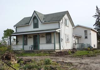
6 HERITAGE IMPACT ASSESSMENT CITY OF BURLINGTON DUNDAS STREET 4 the local cemetery, was relocated to Greenwood Cemetery in Burlington in 1978 in order to accommodate the widening of Dundas St. to four lanes. Similarly, there are no traces remaining of the Tansley Hotel, a frame building that was located beside the railway tracks. It is puzzling that this settlement, with its major east-west and north south roads, its railway crossing and its significant watercourse did not prosper; indeed, for all intents and purposes Tansley had vanished by the 1960 s. 3.0 Description of the Cultural Heritage Resources Dundas Street a) Design This dwelling, according to the City s municipal register, was built in 1865 for George McKinley and is classified as a Grade B structure. Exterior and interior photographs of the building are provided in Appendix G to this report. In terms of design, the structure is categorized as an Ontario Classic storey and a half, with tail, dwelling. The front elevation is symmetrical with a central entrance and features three bays under a peaked cross gable with semi-circular headed, double hung windows. Obvious efforts have been made to retain the original elements of this front façade, although the verandah is a recent replacement on the original footprint. Later additions at the rear of the original rectangular house would seem to be (a) a traditional cross-gabled kitchen tail, plus (b) a recent two-storey wing. Only the front elevation is original; all of the other elevations have been extensively changed over the years. The interior of the original rectangular house retains the typical Ontario Classic arrangement of rooms: living and dining rooms on either side of a central stairway, which leads to second floor bedrooms having fenestration in the gabled end walls. 3.0 Resources The southerly parts of the house reflect more recent popular features such as a
7 HERITAGE IMPACT ASSESSMENT CITY OF BURLINGTON DUNDAS STREET 5 great room. The front verandah is a replacement on the original footprint but without the hipped roof or refined details. The extensive decks at the side and rear are recent, unexceptional additions. The detached garage is insignificant. The mature trees surrounding the dwellings have been removed over the past few weeks and the site therefore looks very different from the undated photographs in the City s Inventory of Cultural Heritage Resources. b) Physical Condition The house appears to have been occupied until a short time ago. The two-storey addition to the south is very recent. It would appear as though construction was not complete when the house was vacated. Interestingly, the north-facing elevation has been retained with its original cladding, windows, door and frames. Other faces of the dwelling have been reclad with modern vinyl siding and windows and no significant features remain. Considering its age, the structure is in fair condition, with a few minor failures in not-unexpected locations such as stone foundation corners. The interior has few original features remaining, except possibly the staircase and some door and window trim. The semi-circular headed window in the cross-gable appears to be original and is in good, reparable condition. While the dwelling could be restored to a liveable and pleasant condition, it would require removing most interior and exterior finishes of the original portions, relocating the building onto a new foundation (probably in two or three parts), insulating to modern standards and providing new heating, air conditioning and electrical systems. The most southerly addition, which is very recent, could be lived in at any time but is not a self-sufficient structure. 3.0 Resources Dundas Street a) Design
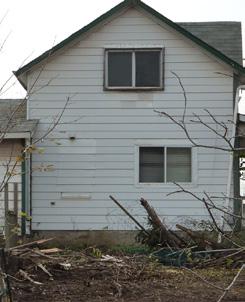
8 HERITAGE IMPACT ASSESSMENT CITY OF BURLINGTON DUNDAS STREET 6 This dwelling, according to the City s municipal register, was built prior to 1877 and is classified as a Grade B structure. Exterior and interior photographs of the building are provided in Appendix H to this report. In terms of design, it is categorized as a two storey with single storey tail Ontario Classic dwelling. The front elevation is symmetrical with a central entrance and three bays under a peaked, cross gable with semi-circular headed, double-hung windows. The original full-width verandah has been replaced by an enclosed porch. The east and west-facing elevations have four well-proportioned, double-hung windows: two upstairs and two downstairs, symmetrical about the central roof peak. The arrangement and proportions are what one would expect in a classical vernacular house in mid-19 th century Ontario. The quasi-saltbox shape given to the original rectangular structure by the kitchen wing at the back also could indicate a construction date from the middle of the 19 th century. The projecting great room wing at the rear is of quite recent construction, as are the wood decks. The basement reveals the very early (in Ontario terms) construction date: unpeeled log first floor joists supported by squared timber beams, sills and round log columns. The basement walls are constructed of 20 th century concrete block masonry. The original room layout would have been the typical classical vernacular centre hall, major rooms to each side, two bedrooms to each side of a small second floor landing. The staircase is unusually wide. The kitchen in the saltbox-shaped tail has been much altered but reflects the typical, utilitarian original outlines. The house has been re-clad in modern, simulated-clapboard siding, presumably over a wood frame and wood clapboard. 3.0 Resources The one outbuilding on the property has its own significance: it is a good example of the type of individual workshop that was prevalent in 19 th century/ early 20 th century Ontario. It is an all-wood structure, with heavy timber framing, wood cladding, windows and doors. There have been some unfortunate
9 HERITAGE IMPACT ASSESSMENT CITY OF BURLINGTON DUNDAS STREET 7 alterations, but the strong vernacular character shows through. Any vergeboard trim has been removed from the house. Window frames and sash are wood, double-hung, but may not be original. As with no. 5218, virtually all trees and shrubs have been recently removed from the property, resulting in a markedly different appearance from the undated photograph in the City s inventory. b) Physical Condition The ground floor structure visible in the basement indicates an early date of construction: unpeeled log floor joists, rough-sawn heavy timber beams and sills. There is no apparent deterioration from moisture. The foundation walls are 20 th century concrete block, indicating that either the house was moved onto a new foundation or was raised, the old stone foundation removed, and a new block structure built under it. There may have been a foundation wall under the central timber beam, as the beam shows signs of horizontal stress. The ground floor and second floor retain the original centre hall plan with the staircase rising from the kitchen (south) side to the semi-circular headed window in the cross gable. Interior finishes are in good condition, of different ages but all well-maintained. The great room addition to the south side of the kitchen is recent and in good condition. The wooden deck abutting the dwelling is somewhat the worse for wear in spite of being of recent construction. The enclosing of the verandah has resulted in significant changes to the front of the original house, but none of it appears irreversible. In conclusion, while the house exhibits many alterations carried out over the decades, none have destroyed the basic structure of the house. Until this year, it would appear to have been a comfortable, cared-for dwelling. 3.0 Resources
10 HERITAGE IMPACT ASSESSMENT CITY OF BURLINGTON DUNDAS STREET Assessment of Cultural Heritage Value of the Resource The cultural heritage resources on the subject property have been evaluated against the criteria outlined in Regulation 9/06 under the Ontario Heritage Act for determining cultural heritage value or interest, as follows: 1. The property has design value or physical value because it, i. is a rare, unique, representative or early example of a style, type, expression, material or construction method. ii. displays a high degree of craftsmanship or artistic merit, or iii. demonstrates a high degree of technical or scientific achievement. 2. The property has historical value or associative value because it, i. has direct associations with a theme, event, belief, person, activity, organization or institution that is significant to a community, ii. yields, or has the potential to yield, information that contributes to an understanding of a community or culture, or iii. demonstrates or reflects the work or ideas of an architect, artist, builder, designer or theorist who is significant to a community. 3. The property has contextual value because it, i. is important in defining, maintaining or supporting the character of an area, ii. is physically, functionally, visually or historically linked to its surroundings, or iii. is a landmark. 4.0 Value Our evaluation of this cultural heritage resource in terms of the criteria outlined in Regulation 9/06 follows. Criteria no. 1 design/physical value: The houses on the property are typical examples of Ontario Classic rural dwellings that are not unique or rare in Burlington (with the exception of the beams and joists in the basement of no. 5226, as described earlier), do not display a particularly high degree of craftsmanship or artistic merit, or demonstrate a high degree of technical or scientific achievement. Even the bucolic nature of the setting that is apparent in the City s photographic record has disappeared with the removal of the vegetation from the property.
11 HERITAGE IMPACT ASSESSMENT CITY OF BURLINGTON DUNDAS STREET 9 Criteria no. 2 historical/associative value: The subject property has an association with the early settlement of Tansley and contains two of only three buildings remaining from a once-thriving community at the junction of Dundas St. and Appleby Line. As noted earlier, no may have been used as the village post office for a number of years, although we do not have definitive evidence at this time. It has no direct association with a theme, event, institution, etc. that is or was significant to a community other than the possibility that it was the village post office. Criteria no. 3 contextual value: The subject property helps to define the location of the former settlement, but only in a hypothetical sense due to the absence of a tangible historic community. Similarly, it is physically, functionally and historically linked with the development of a long-forgotten settlement, but neither dwelling can be considered a landmark. Furthermore, the surroundings exhibit virtually no visible traces of the former village, with the exception of the dwelling to the east. Driving by the property on Dundas St., one does not gain an appreciation of the history of Tansley or even a perception that a thriving village once existed at this location. Rather, the dwellings stand out in stark contrast to the highway commercial/suburban residential character of surrounding land uses. 4.0 Value
12 HERITAGE IMPACT ASSESSMENT CITY OF BURLINGTON DUNDAS STREET Description of the Proposal New Horizon Development Group (Sutton) Inc. has recently purchased Dundas St., along with a vacant lot to the west, resulting in the three lots being consolidated into one holding. Preliminary plans have been submitted to the municipality to construct a 4-storey mixed-use project featuring retail uses on the ground floor with a total of 248 apartments above (see Appendix F preliminary site plan). Neither of the existing dwellings have been incorporated into the design of the project. Access to the units would be provided from Sutton Road and a majority of the parking would be underground. In keeping with contemporary urban design guidelines, the building would be sited very close to both Dundas St. and Sutton Rd., with a row of parking separating the apartments from the subdivision to the south. The proposal has been deemed by the City to conform with the Official Plan designation of Neighbourhood Commercial, but an amendment to the zoning by-law is required to rezone it to an appropriate zoning category with applicable performance standards. The preparation and submission of a heritage impact assessment is required in order for the application to be deemed complete. 6.0 Description of Potential Impacts The obvious impact of the proposed development is that the heritage resources would be lost due to the intended demolition of the listed structures on the property Proposal & Impacts
13 HERITAGE IMPACT ASSESSMENT CITY OF BURLINGTON DUNDAS STREET Identification of Conservation Options As is the case with any redevelopment involving existing buildings, there are essentially three options available to the developer: d. develop around the buildings (retention option); e. demolish the buildings; or, f. re-locate the buildings to another site. We have examined the advantages and disadvantages of each option, bearing in mind the significance (in this case, the lack of significance) of the heritage resource, the context of the resource and applicable heritage conservation policies. Option (1) retention The advantage of this option is that it would retain the heritage resource, but would not be compatible with the current redevelopment plans. The disadvantages are numerous: to design around the two existing dwellings would essentially negate the possibility of developing the site for its intended uses (commercial and residential), given the deep setbacks of the buildings from Dundas St. and the width of the former lots; given the condition of the dwellings, it would take a substantial investment to bring them up to current residential standards in order to market them; since continuation of direct access to Dundas St. would be highly unlikely, an access road would have to be provided from Sutton Dr. which may cause adverse traffic impacts on Dundas due to its proximity. Option (2) relocation The advantage of this option is that the heritage resource would not be lost entirely, although it would lose its contextual value as the dwellings would leave their original site. The disadvantage of this option is that there is an extremely limited market for relocated houses, especially those that are not in good or excellent condition. As an example, the provincial Ministry of Transportation is having great difficulty 7.0 Conservation
14 HERITAGE IMPACT ASSESSMENT CITY OF BURLINGTON DUNDAS STREET 12 finding buyers for the dwellings that have to be moved out of the way of Hwy. 407 through Durham Region, most of which are in excellent condition. It is suggested that the limited heritage significance and appeal of the homes makes it highly unlikely that any purchasers would be interested in investing in this kind of project. Option (3) demolition The advantages of this option are that it would permit the site to be developed in accordance with the intent of the Official Plan, without the owner having to create a brand new plan that would likely not be economically viable. The disadvantage of this option is that it would result in a modest heritage resource being lost, although the impact of the loss could be mitigated (see below). In our opinion option no. 3 is the preferred option for this property, in view of the following factors: the heritage resource is only marginal at best, for the reasons outlined earlier in this report; the heritage resource has lost its contextual value, with the virtual disappearance of the community of Tansley and the conversion of the surrounding lands from agricultural to urban; designing a new plan around the existing buildings would be very difficult, in view of access constraints, buffering requirements, marketing considerations, etc. 8.0 Mitigation of Impacts It is suggested that the impact of demolishing the listed buildings in question could be mitigated by compiling a complete documented record for each of the buildings, including photographs, measured drawings, and relevant material from the City s archives, in keeping with policy (d) of the Official Plan. 8.0 Impacts
15 HERITAGE IMPACT ASSESSMENT CITY OF BURLINGTON DUNDAS STREET Conclusion Nos and 5226 Dundas St., when built in the 19 th century, would have been substantial structures within the community of Tansley. Each dwelling still displays typical features of house design true to their time; however, much of their character has been lost due to the heavy traffic volumes on Dundas, removal of landscaping, and lack of maintenance since the last residents vacated the premises. More importantly, almost all vestiges of the community of Tansley save these two dwellings and the one to the east have disappeared and they no longer serve as reminders of the historic settlement. We have examined the criteria set out in Ontario Regulation 9/06 and concluded that the subject property does not meet the criteria for designation under Part IV of the Ontario Heritage Act, for the reasons outlined in section 4 of this report. Furthermore, we do not find that the benefits of retaining the heritage resources on the subject site outweigh the disadvantages of doing so. We have therefore concluded that the demolition option is warranted, in order to implement the intent of the Official Plan for this particular location. 9.0 Conclusion

16 HERITAGE IMPACT ASSESSMENT CITY OF BURLINGTON DUNDAS STREET 14 GOOGLE MAP Appendix A Location Plan

17 HERITAGE IMPACT ASSESSMENT CITY OF BURLINGTON DUNDAS STREET 15 Appendix B 1877 Halton County Atlas Extract
18 HERITAGE IMPACT ASSESSMENT CITY OF BURLINGTON DUNDAS STREET 16 [see attached] Appendix C Official Plan Schedule B

19 HERITAGE IMPACT ASSESSMENT CITY OF BURLINGTON DUNDAS STREET 17 Appendix D Block Plan

20 HERITAGE IMPACT ASSESSMENT CITY OF BURLINGTON DUNDAS STREET 18 Appendix E Topographical Survey

21 HERITAGE IMPACT ASSESSMENT CITY OF BURLINGTON DUNDAS STREET 19 Appendix F Preliminary Site Plan
22 HERITAGE IMPACT ASSESSMENT CITY OF BURLINGTON DUNDAS STREET 20 Note: Although a number of interior and exterior photographs of the subject property and its surroundings were captured, we have included only a representative sample of the collection in this report. Prints of the remaining photos are available if required. Appendix G Photographs of 5218 Dundas Street


23 HERITAGE IMPACT ASSESSMENT CITY OF BURLINGTON DUNDAS STREET 21 Appendix G Photographs of 5218 Dundas Street


24 HERITAGE IMPACT ASSESSMENT CITY OF BURLINGTON DUNDAS STREET 22 Appendix G Photographs of 5218 Dundas Street


25 HERITAGE IMPACT ASSESSMENT CITY OF BURLINGTON DUNDAS STREET 23 Appendix H Photographs of 5226 Dundas Street


26 HERITAGE IMPACT ASSESSMENT CITY OF BURLINGTON DUNDAS STREET 24 Appendix H Photographs of 5226 Dundas Street


27 HERITAGE IMPACT ASSESSMENT CITY OF BURLINGTON DUNDAS STREET 25 Appendix H Photographs of 5226 Dundas Street

28 HERITAGE IMPACT ASSESSMENT CITY OF BURLINGTON DUNDAS STREET 26 Appendix I Newspaper Articles

29 HERITAGE IMPACT ASSESSMENT CITY OF BURLINGTON DUNDAS STREET 27 Appendix I Newspaper Articles

30 HERITAGE IMPACT ASSESSMENT CITY OF BURLINGTON DUNDAS STREET 28 Appendix I Newspaper Articles

31 HERITAGE IMPACT ASSESSMENT CITY OF BURLINGTON DUNDAS STREET 29 Appendix I Newspaper Articles
CHAIR AND MEMBERS PLANNING & ENVIRONMENT COMMITTEE MEETING ON MONDAY AUGUST 28, 2017 JOHN M. FLEMING MANAGING DIRECTOR, PLANNING AND CITY PLANNER
 TO: FROM: SUBJECT: CHAIR AND MEMBERS PLANNING & ENVIRONMENT COMMITTEE MEETING ON MONDAY AUGUST 28, 2017 JOHN M. FLEMING MANAGING DIRECTOR, PLANNING AND CITY PLANNER REQUEST FOR DEMOLITION OF HERITAGE LISTED
43: 2165 Dundas St. West, Smith-Carrique Barn and Shed
 1. Description of Property Municipal Address Name (if applicable) Legal Description Location of Property Ownership Access Current Use Existing Designation General Description Priority Level 43: 2165 Dundas
L 4-1. Heritage Report: Reasons for Heritage Designation. Kodors House. 35 Rosedale Avenue West
 L 4-1 Brampton Heritage Board Date: January 17, 2012 Heritage Report: Reasons for Heritage Designation Kodors House 35 Rosedale Avenue West December 2011 1 L 4-2 Profile of Subject Property Municipal Address
6: 2417 Fourth Line, Sixteen Hollow, Lion Valley Park
 1. Description of Property 6: 2417 Fourth Line, Sixteen Hollow, Lion Valley Park Municipal Address 2417 Fourth Line ame (if applicable) Sixteen Hollow, Lion Valley Park Legal Description CO 1 SDS PT LOTS
Memo. B R A Y H e r i t a g e
 6 1 3. 5 4 2. 3 3 9 3 6 1 3. 5 4 9. 6 2 3 1 c a r l @ b r a y h e r i t a g e. c o m Memo To: Jennifer Murray, Windmill Development Corporation From: Carl Bray, Bray Heritage Date: Monday, June 5, 2017
TOWN OF AURORA HERITAGE IMPACT ASSESSMENTS AND CONSERVATION PLANS GUIDE
 PLANNING AND DEVELOPMENT SERVICES Development Planning Division Heritage Planning Section Phone: 905-727-3123 ext. 4226 Fax: 905-726-4736 Email: planning@aurora.ca Town of Aurora 100 John West Way, Box
58: 1285 Sedgewick Crescent, Rotary Gardens
 1. Description of Property Municipal Address Name (if applicable) Legal Description Location of Property Ownership Access Current Use Existing Designation General Description Priority Level 58: 1285 Sedgewick
Demolition of a Designated Heritage Property Roncesvalles Avenue
 REPORT FOR ACTION Demolition of a Designated Heritage Property - 421 Roncesvalles Avenue Date: March 8, 2018 To: Toronto Preservation Board Toronto and East York Community Council From: Acting Chief Planner
PLANNING JUSTIFICATION REPORT
 PLANNING JUSTIFICATION REPORT 55 DELHI STREET CITY OF GUELPH PREPARED FOR: VESTERRA PROPERTY MANAGEMENT PREPARED BY: LABRECHE PATTERSON & ASSOCIATES INC. SCOTT PATTERSON, BA, CPT, MCIP, RPP PRINCIPAL,
1. Description of Property
 1. Description of Property 39: 2483 Burnhamthorpe Rd. West, Schellenberg Stables Municipal Address 2483 Burnhamthorpe Rd. West ame (if applicable) Schellenberg Stables Legal Description PT LT 30, CO 2
Chapter 6 cultural heritage
 6 Cultural Heritage 6.1 Protecting Vaughan s Cultural Heritage 165 6.1.1 Protecting Vaughan s Cultural Heritage 165 6.1.2 Maintaining a Heritage Inventory 166 6.1.3 Promoting Vaughan s Cultural Heritage
57: 2031 North Service Road West, Hilton Farm
 1. Description of Property Municipal Address Name (if applicable) Legal Description Location of Property Ownership Access Current Use Existing Designation General Description Priority Level 57: 2031 North
141 GEORGE STREET PLANNING RATIONALE
 141 GEORGE STREET PLANNING RATIONALE MINOR ZONING BY-LAW AMENDMENT NOVEMBER 2, 2016 PLANNING RATIONALE 223 McLeod Street Ottawa, ON K2P 0Z8 613.730.5709 fotenn.com INTRODUCTION FOTENN Consultants is acting
52: 2182 Lakeshore Road East, Horizons
 1. Description of Property Municipal Address Name (if applicable) Legal Description Location of Property Ownership Access Current Use Existing Designation General Description Priority Level 52: 2182 Lakeshore
SUBJECT: Report recommending 563 North Shore Boulevard East remain on the Municipal Register of Cultural Heritage Resources
 Page 1 of Report PB-61-14 TO: FROM: Development and Infrastructure Committee Planning and Building SUBJECT: Report recommending 563 North Shore Boulevard East remain on the Municipal Register of Cultural
Architectural Inventory Form (page 1 of 5)
") OAHP1403 Rev. 9/98 COLORADO CULTURAL RESOURCE SURVEY (page 1 of 5) Official eligibility determination (OAHP use only) Date Initials Determined Eligible- NR Determined Not Eligible- NR Determined Eligible-
OAHP1403 Rev. 9/98 COLORADO CULTURAL RESOURCE SURVEY (page 1 of 5) Official eligibility determination (OAHP use only) Date Initials Determined Eligible- NR Determined Not Eligible- NR Determined Eligible-
Mark-up of the effect of the proposed Bronte Village Growth Area OPA No.18 on the text of section 24, Bronte Village, of the Livable Oakville Plan
 Mark-up of the effect of the proposed Bronte Village Growth Area OPA No.18 on the text of section 24, Bronte Village, of the Livable Oakville Plan Notes: This document is provided for information purposes
APPENDIX F CULTURAL HERITAGE RESOURCE ASSESSMENT
 APPENDIX F CULTURAL HERITAGE RESOURCE ASSESSMENT TO Katherine Jim, MRC DATE February 28, 2013 (Revised March 6 2013, May 27 2013, June 24 2013) FROM Lindsay Popert, ASI ASI FILE 12EA-084 RE Dundas Street
APPENDIX 9 HERITAGE CHARACTER
 APPENDIX 9 HERITAGE CHARACTER Defining attributes and features Perth Official Plan Appendix 9 HERITAGE CHARACTER defining attributes and features This appendix includes a table describing heritage attributes
M E M O R A N D U M PLANNING AND COMMUNITY DEVELOPMENT DEPARTMENT CITY OF SANTA MONICA PLANNING DIVISION
 M E M O R A N D U M 10-B PLANNING AND COMMUNITY DEVELOPMENT DEPARTMENT CITY OF SANTA MONICA PLANNING DIVISION DATE: April 9, 2018 TO: FROM: SUBJECT: The Honorable Landmarks Commission Planning Staff 133
THE CITY OF LAKE FOREST HISTORIC PRESERVATION COMMISSION LOCAL LANDMARK NOMINATION INSTRUCTIONS
 THE CITY OF LAKE FOREST HISTORIC PRESERVATION COMMISSION LOCAL LANDMARK NOMINATION INSTRUCTIONS This application is for the nomination of individual properties as Local Historic Landmarks within the City
Urban Design Brief Woodland Cemetery Funeral Home 493 Springbank Drive
 Urban Design Brief Woodland Cemetery Funeral Home The Incorporated Synod of the Diocese of Huron April 15, 2016 Urban Design Brief April 15, 2016 TABLE OF CONTENTS Page No. INTRODUCTION... 1 SECTION 1
Conservation Area Designation, amendments and Review
 Conservation Area Designation, amendments and Review Location: No.s 37-49 (odd) Twickenham Road Date Assessed: January 2018 Adjacent Conservation Area Significance: Teddington Lock CA. The Teddington Lock
2154 Dundas Street West Intention to Designate under Part IV, Section 29 of the Ontario Heritage Act
 STAFF REPORT ACTION REQUIRED 2154 Dundas Street West Intention to Designate under Part IV, Section 29 of the Ontario Heritage Act Date: February 2, 2009 To: From: Toronto Preservation Board Toronto and
21: Sovereign Street, Streetscape
 1. Description of Property Municipal Address ame (if applicable) Legal Description Location of Property Ownership Access Current Use Existing Designation General Description Priority Level 21: Sovereign
Wide asphalt driveway abutting school property. garage built with incompatible materials, too close to park. incompatible fencing materials
 Wide asphalt driveway abutting school property incompatible fencing materials garage built with incompatible materials, too close to park Lack of plantings as a buffer between private property and open
AGINCOURT SECONDARY PLAN
 1 AGINCOURT SECONDARY PLAN 1. AGINCOURT SECONDARY PLAN The following policies and principles apply to the area herein referred to as Agincourt, as outlined on Map 1-1. 1. GENERAL POLICIES 1.1 This Secondary
CHAIR AND MEMBERS PLANNING AND ENVIRONMENT COMMITTEE ON TUESDAY MARCH 29, 2016
 TO: FROM: SUBJECT: CHAIR AND MEMBERS PLANNING AND ENVIRONMENT COMMITTEE ON TUESDAY MARCH 29, 2016 JOHN M. FLEMING MANAGING DIRECTOR, PLANNING AND CITY PLANNER DESIGNATION OF 864-872 DUNDAS STREET UNDER
Toronto Preservation Board Toronto and East York Community Council. Director, Policy and Research, City Planning Division
 STAFF REPORT ACTION REQUIRED 104 John Street - Alteration to a Heritage Property and Intention to Designate, Part IV, Section 29, Ontario Heritage Act and Authority to Enter Into a Heritage Easement Agreement
Historic Resources Inventory Evaluation Form
 Evaluation Date September 12, 2017 Historic Resources Inventory Evaluation Form Community District Designation Downtown Grade 1 The place should be rated for each of the criteria below, in order to establish
Bressa Developments Limited. Planning Justification Report. Revised Draft Plan of Subdivision and Zoning By-Law Amendment
 Bressa Developments Limited Revised Draft Plan of Subdivision and Zoning By-Law Amendment Planning Justification Report Part of Lots 7 & 8 Concession 1, North of Dundas Street Town of Oakville September,
Architectural Inventory Form
 COLORADO CULTURAL RESOURCE SURVEY Page 1 of 8 Official Eligibility Determination (OAHP use only) Rev. 9/98 OAHP1403 Date Initials Determined Eligible National Register Determined Not Eligible National
CULTURAL HERITAGE RESOURCES POLICIES
 New Official Plan CULTURAL HERITAGE RESOURCES POLICIES Date March 6, 2009 Distributed at: Livable Oakville Committee, March 9, 2009 Planning Services Department March 2009 1 1 Policy Discussion Paper:
PORT WHITBY COMMUNITY
 PORT WHITBY COMMUNITY SECONDARY PLAN UPDATE COMMUNITY IMPROVEMENT PLAN URBAN DESIGN GUIDELINES September 2015 DRAFT PROPOSED AMENDMENT NUMBER # to the Whitby Official Plan PURPOSE: The intent of this Amendment
NOTE: PLEASE REFER TO CITY PLAN FOR ADDITIONAL CITY-WIDE POLICIES WHICH APPLY TO THIS DISTRICT.
 NOTE: THE POLICIES IN THIS DOCUMENT ARE SPECIFIC TO THE SHERIDAN RESIDENTIAL PLANNING DISTRICT OF, AND MUST BE READ IN CONJUNCTION WITH ALL THE POLICIES OF CITY PLAN PLEASE REFER TO FOR ADDITIONAL CITY-WIDE
6 PORT SYDNEY SETTLEMENT AREA
 Section 6 Port Sydney Page 61 6 PORT SYDNEY SETTLEMENT AREA 6.1 Basis and Principles Village of Port Sydney Waterfront Community Existing Services 6.1.1 Port Sydney is an historic settlement that has developed
Access not granted, notes and photographs from the street Sept (AB) Current Use
 Current Use") 1. Description of Property 49: 1248-1250 Lakeshore Road East, Grenvilla Lodge Municipal Address 1248-1250 Lakeshore Road East ame (if applicable) Grenvilla Lodge. (Incorrectly spelled in the Heritage Register
1. Description of Property 49: 1248-1250 Lakeshore Road East, Grenvilla Lodge Municipal Address 1248-1250 Lakeshore Road East ame (if applicable) Grenvilla Lodge. (Incorrectly spelled in the Heritage Register
Tazewell Pike. Neighborhood Conservation Overlay District Design Guidelines
 Tazewell Pike Neighborhood Conservation Overlay District Design Guidelines Knoxville Knox County Metropolitan Planning Commission November 2, 2000 These design guidelines were: Adopted by the Knoxville
2136 & 2148 Trafalgar Road Town of Oakville Region of Halton
 PLANNING JUSTIFICATION REPORT 2136 & 2148 Trafalgar Road Town of Oakville Region of Halton Zoning By-Law Amendment Application 2500674 Ontario Inc. November 2016 Table of Contents Page 1.0 Location/Summary
ONTARIO MUNICIPAL BOARD
 PL 120483 ONTARIO MUNICIPAL BOARD Applicant/Appellant: 2124123 Ontario Limited Subject: OPA, Rezoning and Draft Plan of Subdivision Municipal Address: 3940 Highway 7 East Municipality: City of Markham
2: Bond Street, I.O.F Orphanage
 1. Description of Property 2: 37-53 Bond Street, I.O.F Orphanage Municipal Address 37-53 Bond Street ame (if applicable) Independent Order of Foresters (I.O.F.) Orphanage Legal Description PT LTS 15 &
Garden District Heritage Conservation District Study
 Garden District Heritage Conservation District Study Community Consultation Meeting September 24 th, 2013 What is a Heritage Conservation District? A defined area of heritage significance and character
Figure 1- Site Plan Concept
 Figure 1- Site Plan Concept Parking will be provided underground on three levels at rate of 1.0 space/ unit; this rate includes all visitors parking. MMM Group has prepared a parking assessment (April,
Cookstown Heritage Conservation District Plan Heritage Workshop Public Open House September 10, 2013
 Heritage Workshop Public Open House September 10, 2013 Funded by the Government of Ontario MMM Group Darryl Bird Project Manager, Senior Planner Shannon Baker Senior Landscape Architect, CAHP AREA Architects
178 Carruthers Properties Inc.
 178 Carruthers Properties Inc. Planning Rationale for 178 Carruthers Avenue Site Plan Control Application June 2014 Table of Contents 1.0 Introduction 2.0 Overview of Subject Property 3.0 Current Zoning
KANATA CENTRUM 255 KANATA AVENUE OFFICIAL PLAN AMENDMENT ZONING BY-LAW AMENDMENT
 KANATA CENTRUM 255 KANATA AVENUE OFFICIAL PLAN AMENDMENT ZONING BY-LAW AMENDMENT JUNE 2015 PREPARED BY: FOTENN Consultants Inc. 223 Mcleod Street Ottawa, ON K2P OZ8 (613) 730-5709 PREPARED FOR: Kanata
Cultural Heritage Landscapes Strategy
 Cultural Heritage Landscapes Strategy TABLE OF CONTENTS Executive Summary 1.0 Introduction 1.1 Objectives of the Strategy 2.0 Definition and Identification of Cultural Heritage Landscapes 2.1 Definitions
GUIDELINES FOR CULTURAL HERITAGE IMPACT ASSESSMENTS
 GUIDELINES FOR CULTURAL HERITAGE IMPACT ASSESSMENTS Purpose A Cultural Heritage Impact Assessment (CHIA) is a study to identify and evaluate built heritage resources and cultural landscapes in a given
1. Description of Property
 1. Description of Property Municipal Address Name (if applicable) Legal Description Location of Property Ownership Access Current Use Existing Designation General Description Priority Level 34: 1141 Burnhamthorpe
L 1-1. Reason. ns for Heritage Designa
 L 1-1 Herita age Repo ort: Reason ns for Heritage Designa ation Brampton Heritage Board Date: April 15, 2014 10300 Th he Gore Road Former Castlemore Sch hool S.S. No. 6 Ap pril 2014 4 L 1-2 Profile of
VILLAGE OF BOLTON HERITAGE CONSERVATION DISTRICT PLAN
 Page 1 1. INTRODUCTION AND BACKGROUND 1.1 THE PROJECT VILLAGE OF BOLTON HERITAGE CONSERVATION DISTRICT PLAN TERMS OF REFERENCE The Town of Caledon (Town) is a large, predominantly rural municipality with
50: 1475 Lakeshore Road East, Ryrie Estate
 1. Description of Property 50: 1475 Lakeshore Road East, Ryrie Estate Municipal Address 1475 Lakeshore Road East Name (if applicable) Ryrie Estate Legal Description PT LT 6, CON 3 TRAFALGAR, SOUTH OF DUNDAS
East Panorama Ridge Concept Plan Amendment
 Page 1 of 7 L003 : East Panorama Ridge Concept Plan Amendment Corporate NO: L003 Report COUNCIL DATE: March 4, 2002 REGULAR COUNCIL LAND USE TO: Mayor & Council DATE: February 27, 2002 FROM: General Manager,
Mayfield West Phase 2 Secondary Plan
 Town of Caledon Mayfield West Phase 2 Secondary Plan Built Heritage Resources & Cultural Heritage Landscapes Assessment André Scheinman Heritage Preservation Consultant / ENVision The Hough Group Assignment
Toronto and East York Community Council Item TE34.30, as adopted by City of Toronto Council on August 25, 26, 27 and 28, 2014 CITY OF TORONTO
 Authority: Toronto and East York Community Council Item TE34.30, as adopted by City of Toronto Council on August 25, 26, 27 and 28, 2014 CITY OF TORONTO BY-LAW 1393-2017 To designate the property at 481
Authority: North York Community Council Item 31.7, as adopted by City of Toronto Council on May 6, 7 and 8, 2014 CITY OF TORONTO. BY-LAW No.
 Authority: North York Community Council Item 31.7, as adopted by City of Toronto Council on May 6, 7 and 8, 2014 CITY OF TORONTO BY-LAW No. 53-2015 To designate the property at 65 Centre Avenue (Alexander
5: Cross Avenue Bridge, Sixteen Mile Creek Rail Bridge
 1. Description of Property Municipal Address Name (if applicable) Legal Description Location of Property Ownership Access Current Use Existing Designation General Description Priority Level 5: Cross Avenue
Planning Justification Brief
 Planning Justification Brief Proposed Re-Zoning Halton Catholic District School Board 302, 312, 324, 332 Rebecca Street Lots 4, 5, 6, & 7 and Blocks A & B Registered Plan 552 May 2017 Introduction Strategy
MILTON HEIGHTS COMMUNITY January 2006 Revised February 2015 Revised November 2015
 REVISED DRAFT MILTON HEIGHTS COMMUNITY January 2006 Revised February 2015 Revised November 2015 Urban Design Guidelines Milton Heights Landowners Group This page has been intentionally left blank. Contents
Ottawa Historic Resources Inventory: Commercial Historic District Building Information. Significance and Potential Eligibility
 C 01 1 Address: address 1 PIN: 21 11 218 001 Plan: Rectangular Stories: 2 Original Owner: Roof Type: Flat Building Names: Marquette School Foundation: Important Dates: ca 1955 Walls: BRICK Architect /
Access was not granted. Photographed from road, September 16 th, 2015 (AB) Current Use
 Current Use") 1. Description of Property 32: 191 Burnhamthorpe Rd. East, McDuffie Farm Municipal Address 191 Burnhamthorpe Rd. East ame (if applicable) McDuffie Farm (also spelled McDuffe) Legal Description PT LT 14,
1. Description of Property 32: 191 Burnhamthorpe Rd. East, McDuffie Farm Municipal Address 191 Burnhamthorpe Rd. East ame (if applicable) McDuffie Farm (also spelled McDuffe) Legal Description PT LT 14,
Morgan s Subdivision Historic District Character-defining Features
 Morgan s Subdivision Historic District Character-defining Features DISTRICT DESCRIPTION This small addition, designed as a neighborhood for those wishing to move east from Capitol Hill, was predominantly
DRAFT Northeast Quadrant of Kipling Avenue and Highway 7 DRAFT AUGUST 29, Goals Land Use. The goals of this Plan are to:
 AUGUST 29, 2017 12.15 Northeast Quadrant of Kipling Avenue and Highway 7 12.15.1 Goals 12.15.2 Land Use The goals of this Plan are to: 12.15.2.1 General Provisions: a) Ensure the development of a compact
Bylaw A Bylaw to amend Bylaw 12800, as amended, The Edmonton Zoning Bylaw Amendment No. 2239
 Bylaw 17672 A Bylaw to amend Bylaw 12800, as amended, The Edmonton Zoning Bylaw Amendment No. 2239 WHEREAS City Council at its meeting of February 22, 2001, gave third reading to Bylaw 12800, as amended;
Municipal Inventory of Cultural Heritage Properties - St. Joseph Inventory of Designated and Potential Heritage Properties
 Municipal Inventory of Cultural Heritage Properties - St. Joseph Inventory of Designated and Potential Heritage Properties Municipality of Bluewater, Ontario (Comprised of the former Geographical Townships
Architectural Inventory Form
 COLORADO CULTURAL RESOURCE SURVEY Page 1 of 8 Official Eligibility Determination (OAHP use only) Rev. 9/98 OAHP1403 Date Initials Determined Eligible National Register Determined Not Eligible National
URBAN DESIGN BRIEF. 2136&2148 Trafalgar Road. Town of Oakville
 URBAN DESIGN BRIEF 2136&2148 Trafalgar Road Town of Oakville Prepared By: METROPOLITAN CONSULTING INC For 2500674 Ontario Inc November 2016 TABLE OF CONTENTS Page No. 1.0 Introduction/Description of Subject
New Street Proposed Redevelopment Architecture & Urban Design Brief
 2130 2136 New Street Proposed Redevelopment Architecture & Urban Design Brief Prepared By: Cynthia Zahoruk Architect Inc. 3077 New Street, Burlington, ON, L7N 1M6 TABLE OF CONTENTS Background and Objective
385 Sussex Drive, Ottawa. Application for Minor Zoning By-law Amendment
 Planning Rationale 385 Sussex Drive, Ottawa Application for Minor Zoning By-law Amendment Prepared By: NOVATECH Suite 200, 240 Michael Cowpland Drive Ottawa, Ontario K2M 1P6 October 17, 2014 Novatech File:
URBAN DESIGN BRIEF 181 Burloak Drive, Oakville
 URBAN DESIGN BRIEF 181 Burloak Drive, Oakville February 2017 Our File: 1730B 230-7050 WESTON ROAD / WOODBRIDGE / ONTARIO / L4L 8G7 / T: 905 761 5588/ F: 905 761 5589/WWW.MHBCPLAN.COM TABLE OF CONTENTS
7437, 7439 and 7441 Kingston Road - Zoning By-law Amendment and Site Plan Control Applications - Preliminary Report
 STAFF REPORT ACTION REQUIRED 7437, 7439 and 7441 Kingston Road - Zoning By-law Amendment and Site Plan Control Applications - Preliminary Report Date: August 13, 2015 To: From: Wards: Reference Number:
Architectural Inventory Form (page 1 of 5)
") OAHP1403 Rev. 9/98 COLORADO CULTURAL RESOURCE SURVEY (page 1 of 5) I. IDENTIFICATION 1. Resource number 5RT-2050 2. Temporary resource number: 145008005 3. County: Routt County 4. City: Steamboat Springs
OAHP1403 Rev. 9/98 COLORADO CULTURAL RESOURCE SURVEY (page 1 of 5) I. IDENTIFICATION 1. Resource number 5RT-2050 2. Temporary resource number: 145008005 3. County: Routt County 4. City: Steamboat Springs
Table of Contents 1.0 Introduction
 Table of Contents 1.0 Introduction..1 2.0 Site Description and Surrounding Land Uses 1 3.0 Redevelopment Proposal..3 4.0 Provincial, Regional and Municipal Policy Context... 10 4.1 The Provincial Policy
599 Kennedy Road - Official Plan Amendment and Zoning Amendment Application - Preliminary Report
 STAFF REPORT ACTION REQUIRED 599 Kennedy Road - Official Plan Amendment and Zoning Amendment Application - Preliminary Report Date: March 7, 2017 To: From: Wards: Reference Number: Scarborough Community
9: 204 & 240 Front Street, George Street Parkette & Dingle Park. 1. Description of Property. Name (if applicable) Legal Description
 Legal Description") 1. Description of Property Municipal Address Name (if applicable) Legal Description Location of Property Ownership Access Current Use Existing Designation General Description Priority Level 9: 204 & 240
1. Description of Property Municipal Address Name (if applicable) Legal Description Location of Property Ownership Access Current Use Existing Designation General Description Priority Level 9: 204 & 240
Cultural Heritage Resource Assessment Review Update of the Mayfield West Phase II Secondary Plan TOWN OF CALEDON, ONTARIO.
 TOWN OF CALEDON, ONTARIO Prepared for: Town of Caledon 6311 Old Church Road Caledon, ON L7C IJ6 File: 17CH-030 May 2017 Archaeological & Providing Cultural Heritage Services 528 Bathurst Street Toronto,
Summary of Changes for the Comprehensive Draft Proposed Official Plan Amendment
 Summary of Changes for the Comprehensive Draft Proposed Official Plan Amendment Note: Due to the broad scope of the Official Plan Review, this list is not exhaustive of the extent of changes in the comprehensive
HISTORIC SITE FORM - HISTORIC SITES INVENTORY PARK CITY MUNICIPAL CORPORATION (10-08) 1 IDENTIFICATION
 1 IDENTIFICATION") HISTORIC SITE FORM - HISTORIC SITES INVENTORY PARK CITY MUNICIPAL CORPORATION (10-08) 1 IDENTIFICATION Name of Property: Address: 158 Main Street City, County: Park City, Summit County, Utah AKA: Tax Number:
HISTORIC SITE FORM - HISTORIC SITES INVENTORY PARK CITY MUNICIPAL CORPORATION (10-08) 1 IDENTIFICATION Name of Property: Address: 158 Main Street City, County: Park City, Summit County, Utah AKA: Tax Number:
11.1 INTRODUCTION. The characteristics of these areas are briefly discussed below.
 SECTION 11 : HERITAGE PRECINCTS 11.1 INTRODUCTION This section applies to some areas within the Residential and Business Resource Areas. The significant resource management issues for this section are
PLANNING RATIONALE FOR 1127, 1128 MILL STREET AND 1125 CLAPP LANE CITY OF OTTAWA
 PLANNING RATIONALE FOR 1127, 1128 MILL STREET AND 1125 CLAPP LANE CITY OF OTTAWA Prepared by: Realty Initiatives and Development On behalf of the Manotick Mill Community Lands Development Corporation March
URBAN DESIGN BRIEF Gordon Street City of Guelph. Prepared on behalf of Ontario Inc. March 25, Project No. 1507
 URBAN DESIGN BRIEF 1131 Gordon Street City of Guelph Prepared on behalf of 1876698 Ontario Inc. March 25, 2016 Project No. 1507 423 Woolwich Street, Suite 201, Guelph, Ontario, N1H 3X3 Phone (519) 836-7526
Eastern Golf Course, Doncaster Road, Doncaster
 , 463-535 Road, Heritage Assessment in accordance with Schedule to the Development Plan Overlay July 2013 bryce raworth conservation urban design 19 Victoria Street St Kilda Vic 3182 , 463-535 Road, Heritage
Purpose of Report...1. Planning Framework Provincial Policy Statement Draft PPS...2. Ontario Heritage Act...3
 Cultural Heritage Policy Discussion Paper November 4 th, 2013 Table of Contents Purpose of Report...1 Planning Framework...1 2005 Provincial Policy Statement...1 2012 Draft PPS...2 Ontario Heritage Act...3
240 and 242 Finch Avenue West Zoning By-law Amendment Application Preliminary Report
 REPORT FOR ACTION 240 and 242 Finch Avenue West Zoning By-law Amendment Application Preliminary Report Date: March 1, 2019 To: North York Community Council From: Director, Community Planning, North York
5.0 VILLAGE AREAS. February 2008 Municipality of West Elgin ~ Official Plan 5-1
 5.0 VILLAGE AREAS This section of the Official Plan deals with the villages of Rodney and West Lorne being the two largest and only fully serviced settlement areas in West Elgin and the most logical and
46: 4022 Fourth Line, Ford-Slacer Farm
 1. Description of Property 46: 4022 Fourth Line, Ford-Slacer Farm Municipal Address 4022 Fourth Line Name (if applicable) Ford-Slacer Farm Legal Description PT LT 21, CON 2 TRAFALGAR, NORTH OF DUNDAS STREET,
DEVELOPMENT MANAGEMENT REPORT
 ITEM A08-1 DEVELOPMENT MANAGEMENT REPORT TO: BY: DATE: DEVELOPMENT: SITE: WARD: APPLICATION: APPLICANT: Development Management Committee Development Manager Proposed live/work unit in connection with existing
TOWN OF AURORA ARCHITECTURAL SALVAGE PROGRAM GUIDE
 PLANNING AND DEVELOPMENT SERVICES Development Planning Division Heritage Planning Section Phone: 905-727-3123 ext. 4226 Fax: 905-726-4736 Email: planning@aurora.ca Town of Aurora 100 John West Way, Box
11: 210 Lakeshore Road East, Towne Square
 1. Description of Property Municipal Address ame (if applicable) Legal Description Location of Property Ownership Access Current Use Existing Designation General Description Priority Level 11: 210 Lakeshore
Long Branch Neighbourhood Character Guidelines Final Report
 STAFF REPORT ACTION REQUIRED Long Branch Neighbourhood Character Guidelines Final Report Date: October 26, 2017 To: From: Wards: Reference Number: Etobicoke York Community Council Director, Community Planning,
Cookstown Heritage Conservation District Study Public Consultation March 26, 2013
 Public Consultation March 26, 2013 Funded by the Government of Ontario MMM Group Darryl Bird Project Manager, Senior Planner, CAHP Intern Shannon Baker Senior Landscape Architect, CAHP AREA Architects
Urban Design Brief Proposed Residential Development 5219 Upper Middle Road City of Burlington
 Urban Design Brief Proposed Residential Development 5219 Upper Middle Road City of Burlington Prepared by Weston Consulting Prepared for BLOOMFIELD DEVELOPMENT INC. Date: March 2017 Table of Contents 1.
NOTE: PLEASE REFER TO MISSISSAUGA PLAN FOR ADDITIONAL CITY-WIDE POLICIES WHICH APPLY TO THIS DISTRICT.
 NOTE: THE POLICIES IN THIS DOCUMENT ARE SPECIFIC TO THE FAIRVIEW PLANNING DISTRICT OF, AND MUST BE READ IN CONJUNCTION WITH ALL THE POLICIES OF PLEASE REFER TO FOR ADDITIONAL CITY-WIDE POLICIES WHICH APPLY
Analysis of Environs of 1000 New York Street, German Methodist Episcopal Church
 Item No. 3: L-14-00028 p.1 Analysis of Environs of New York Street, German Methodist Episcopal Church Step One Historical Significance and Context According to the application for Historic Landmark Designation,
L 3-1. Heritage Report: Reasons for Heritage Designation. Peter Archdekin Farmhouse Mayfield Road
 L 3-1 Heritage Report: Reasons for Heritage Designation Peter Archdekin Farmhouse 4585 Mayfield Road December 2011 1 L 3-2 Profile of Subject Property Municipal Address 4585 Mayfield Road PIN Number 142250084
SUE ROSEN ASSOCIATES. Re: DA DA/485/2016. Thank you etc
 Re: DA DA/485/2016 Thank you etc I m an Epping based heritage consultant commissioned by the Epping Civic Trust to comment on the heritage aspects of the proposed development and on the reportage associated
13 THORNHILL YONGE STREET STUDY IMPLEMENTATION CITY OF VAUGHAN OPA 669 AND TOWN OF MARKHAM OPA 154
 13 THORNHILL YONGE STREET STUDY IMPLEMENTATION CITY OF VAUGHAN OPA 669 AND TOWN OF MARKHAM OPA 154 The Planning and Economic Development Committee recommends the adoption of the recommendations contained
150 Eighth Street Zoning By-law Amendment Application Preliminary Report
 REPORT FOR ACTION 150 Eighth Street Zoning By-law Amendment Application Preliminary Report Date: March 27, 2019 To: Etobicoke York Community Council From: Director, Community Planning, Etobicoke York District
Courtice Main Street Study Community Vision Workshop PLANNING SERVICES DEPARTMENT
 Courtice Main Street Study Community Vision Workshop PLANNING SERVICES DEPARTMENT July 22, 2009 Tonight s Meeting 7:00 pm Introduction David Crome, Director of Planning 7:05 Presentation Stasia Bogdan,
Chapter 8: BEACH SOUTH OF ATLANTIC AVENUE NEIGHBORHOOD PLANNING AREA ANALYSIS
 Chapter 8: BEACH SOUTH OF ATLANTIC AVENUE NEIGHBORHOOD PLANNING AREA ANALYSIS The Beach South of Atlantic Avenue Neighborhood Planning Area includes the parcels adjacent to S Fletcher Avenue from Atlantic