LANDSCAPE AND VISUAL IMPACT ASSESSMENT
|
|
|
- Frederick Mervyn Farmer
- 5 years ago
- Views:
Transcription


1 TANGIER HOUSE TANGIER PARK WOOTTON ST. LAWRENCE RG23 8PH Regeneration & Restoration of Outbuildings LANDSCAPE AND VISUAL IMPACT ASSESSMENT Prepared by: ACLA Ltd For: Mr & Mrs T O'Donohoe Ref: ACLA/BEO Date: 19 th March 2015 Landscape Architects & Designers 9 Hungerford Rd, East Grafton, Marlborough. SN8 3DG T: E:enquiries@acla-ltd.com W:acla-ltd.com
2 CONTENTS: Page No: 1. INTRODUCTION BASELINE CONDITIONS DESCRIPTION OF THE PROPOSALS PLANNING POLICY CONTEXT LANDSCAPE CHARACTER VISUAL AMENITY EFFECTS ON LANDSCAPE FEATURES MITIGATION STRATEGY SUMMARY AND CONCLUSIONS 55. APPENDICES APPENDIX 1 Plans ACLA/BEO 01 ACLA/BEO 02 ACLA/BEO 03 ACLA/BEO 04 Site Context Planning Context & Character Visual Analysis Proposed Layout, Mitigation & Enhancement APPENDIX 2 Photo Viewpoints 1-16 APPENDIX 3 Landscape & Visual Impact Assessment Methodology Ref
3 1. INTRODUCTION 1.1 ACLA Ltd has been instructed by Mr & Mrs T O Donohoe to undertake a Landscape and Visual Impact Assessment relating to a Full Planning Application for the regeneration and restoration of the outbuildings and stables associated with Tangier House, Wootton St. Lawrence, Hampshire. The application site is located across stables, barns, residential bungalows and other ancillary buildings immediately to the north of Tangier House. The application site and Tangier House is located in Tangier Park and is in open countryside approximately 900m east of the small village of Wootton St. Lawrence and is accessed via a minor road running westwards from the village. The Ordnance Survey grid reference for the application site SU and the application site covers an area of approximately 1.0 hectares (ha). 1.2 Tangier House is a substantial Grade II*, listed country house dating back to 1662 occupying a prominent position in the centre of its own parkland extending to approximately 38 ha of woodlands and pasture. The surrounding landscape is predominantly rural parkland estate with isolated properties, farmsteads and occasional larger country houses. The urban edge of Basingstoke is located at 2.6km to the east of the site. The village of Oakley is located at approximately 2km to the south of the application site and the A339 (Kingsclere Road) is located at around 1.7 to 2.6km to the north and east of the application site. The southern boundary of the North Wessex Downs Area of Outstanding natural beauty is located at approximately 600m north of the application site. The area is administered by Basingstoke and Deane Borough Council. 1.3 The purpose of this report is to assess the baseline qualities and value of the existing landscape resource and the visual amenity of the site and its surrounding area, to describe the outline development proposals in their landscape context and to predict the landscape and visual effects (impacts) that may arise from the proposed development. The report will also consider appropriate mitigation strategies for the site, in order to reduce or minimise any effects caused by the development and to put forward initiatives for landscape and visual enhancement. 1.4 Landscape impact assessment aims to determine the likely changes in the physical landscape resulting from a given development and to evaluate the significance of these changes in relation to their effects upon both the quality and character of the landscape. Visual impact assessment predicts the appearance of these physical changes within the landscape and their effects upon specific viewpoints or visual Ref
4 receptors, such as the occupants of residential properties and the users of roads, public rights of way (PRoW) or other public open spaces. 1.5 In order to seek consensus and to minimise subjectivity in the assessment of the existing landscape, wherever possible this report makes reference to published landscape character assessments and other authoritative publications. 1.6 The landscape and visual assessment has been undertaken in accordance with the Guidelines for Landscape and Visual Impact Assessment (Landscape Institute and the Institute of Environmental Management and Assessment, 3rd Edition 2013) and Landscape Character Assessment Guidance for England and Scotland (The Countryside Agency and Scottish Natural Heritage 2002). For a full description of the assessment methodology refer to Appendix 3 at the end of this report. 1.7 This report has been prepared as a stand along appraisal to support the planning application. The Council has not been consulted on the location of key viewpoints and the cumulative impacts of other similar proposals in the area have not been assessed. Ref
5 2. BASELINE CONDITIONS Description of the Existing Site 2.1 The application site and its immediate surroundings include Tangier House and its associated outbuildings, stables, modern agricultural barns, subservient residential property, swimming pool and formal and informal garden areas. A country parkland landscape with woodlands and pasture extend to 92.4 ha surrounding the house. 2.2 The application site itself contains a complex of stables blocks, and other ancillary buildings arranged around a central courtyard immediately to the north of Tangier House. A group of larger steel clad modern agricultural barns are located in the north of the application area just beyond the central courtyard. 2.3 Tangier House is located on the southern application boundary and is a substantial and impressive Grade II* listed country house built in The house is constructed from mellow red brick with a red tile roof and is built in a typical Corolean 1 period H plan with a three gable frontage. It occupies a relatively prominent position within its own parklands. The main frontage of the house has a south-easterly aspect with open lawns and gravel contained by a brick ha-ha. It is accessed from a tarmac driveway approaching the house from an easterly direction leading from the Lodge, which is an isolated residential property at approximately 250m to the east of the main house. It is likely to have been constructed as the gatehouse to Tangier House. 2.4 Outside the application area formal lawns and a high brick garden wall extend northeastwards from Tangiers House and lead to The Wilderness which is a woodland area containing formal paths. This woodland area screens more distant views towards Tangiers House and its outbuildings from the east. Tennis courts are located adjacent to The Wilderness at approximately 100m east of the house. 2.5 A formal walled garden and outdoor swimming pool is located immediately to the south-west of house on the application site boundary. 2.6 The courtyard within the application area to the north of the house is surrounded by a range of residential, agricultural and equestrian buildings arranged around a central courtyard. The more recent buildings are constructed from a variety of materials including timber and steel cladding. The majority of the structures however, with the exception of the large agricultural barns in the north of the application area, are 1 Restoration style relating to the monarchy of Charles II ( )
6 constructed from red brick, some of which may be historical. Tangier Cottage is a modern red brick 20th century bungalow in the west of the application site. Roofing material to the older stables and bungalows are a combination of red tile and slate. The central courtyard contains areas of lawn divided by tarmac paths. A further formal walled garden is located within the application site to the north-east of Tangier House. Many of the internal boundaries are defined by red brick walls, particularly in the west. 2.7 The highest proportion of vegetation on and adjacent to the application site is located on the north-western boundary and comprised of a mixture of evergreen and deciduous trees and shrubs with a semi-domestic character. Some of the evergreen trees have become large and form a relatively dense screen in places. The eastern application boundary is more open with informal lawns and a small orchard and white glass house with a red brick base. 2.8 Areas to the south of the application area are representative of a well-maintained country house with formal gardens. The courtyard within the application area appears to be less well-maintained with an overall inwards facing equestrian/agricultural character. The combination of a complex variation of small-scale buildings with a variety of styles and architectural quality around the courtyards, have a less cohesive character which contrasts with the formality and simplicity of the main house. Overall the modern development detracts from the historic character of Tangier House. 2.9 The large scale agricultural barns with modern cladding dominate the character in the northern sections of the application area and have open boundaries to the north which are visible from a PRoW running north. Therefore when viewed from the north, the grouping of buildings and Tangier House are dominated by the large scale modern barns. At close distance the barns block views to the stables and Tangier House. Therefore the site can appear as a modern farmstead. The Study Area 2.10 The initial area of search for the LVIA was determined by drawing a circle offset by 5km from the proposed development. The extent was set to enable a general understanding of the wider landscape context within which the site is located, while limiting information to that which is most relevant and avoiding excessive analysis. As such it conforms to best-practice guidance These findings were assessed through field observations on the 3 rd March The weather was cloudy with occasional wintery showers. However visibility was good and
7 suitable for assessing the more distant views. A further visit was carried out on the 18 th March. The weather on the day bright and clear The containment by woodlands and tree belts and low ridgelines limited the potential Zone of Visual Influence considerably to approximately 200m to the east, 400m to the west, 800m to the south and up to approximately 1.5km to the north. There are also potential longer distance views possible to the north-west of up to 2km although publicly accessible locations could not be identified during the site visit Low-level views at close distance towards the application site are screened or partially screened from many places by Tangier House and its associated buildings and walls and some intervening vegetation. Linear tree belts associated with field boundaries and PRoW also filter and partially screen many potential views to the proposed development area. Longer distance views to the north are partial screened and glimpsed through woodland belt associated with a Byway Open to All Traffic (BOAT), at around 600m north of the application site. Description of the Surrounding Area 2.14 The predominant characteristics of the surrounding study area are a tranquil rural landscape with narrow county lanes, farm tracks, scattered settlements, farmsteads and occasional rural villages. There is limited intrusion by modern infrastructure. Larger scale agricultural structures are sometimes locally prominent, such as Whitedown Farm and also the barns within the northern sections of the application site itself. Large country houses are also characteristic of the local area in the form of Malshanger and Tangier House with their associated parkland landscape Areas to the north of the application site are slightly more open in character with linear tree belts and an open to semi-enclosed character. A higher proportion of woodland cover to the south west of the study area creates a more enclosed character in places. Field patterns vary from large-scale overall to smaller-scale locally, particularly near settlements or farmsteads The parklands associated with Tangier House with their individual mature trees in managed pasture is a recognisable characteristic to the south and west of Tangier House. Areas to the north of the house and application area tend to be larger-scale arable fields.
8 To the South The land to the south is predominantly rural and is comprised of managed parkland at close distance to Tangier House. PRoW 18 & 3 runs at around 180m south of the application site from The Lodge eastwards towards Wych Hazel Copse. From the footpaths there will be some close distance views towards Tangier House and buildings within the western sections of the proposed development area. Views towards upper sections of the modern barns in the northern sections of the application area are screened by intervening buildings and vegetation within and adjacent to the application site. A further PRoW runs southwards from the driveway to Tangier House to meet PRoW 18. Again, views into the application site are currently screened by Tangier House and associated buildings and the modern barns in the north of the application area are not apparent The Lodge is an isolated property adjacent to the driveway to Tangier House at approximately 250m to distance. The land beyond the parkland falls away gently towards a shallow valley located in large-scale arable fields. Locally the area is relatively open. A track and PRoW 17b leads towards The Sawmills, Manydown Cottages and Fir Cottages located on a low ridgeline at around 700m south of the application site. The properties are arranged in a loose cluster situated on a low spur to the southern valley side. There are potentially localised filtered views through intervening field boundary tree belts towards Tangier House from the properties and nearby PRoW. However many of the potential views into the application site will be screened by Tangier House and some of the associated structures. During summer the intervening trees will further screen views. Beyond these properties the landscape becomes increasingly wooded and it is unlikely that there will be any significant views from other publicly accessible locations or properties due to intervening vegetation. To the West The land to the west of the proposed development close to the application site has a managed parkland character with individual trees and pasture. The land falls gently westwards to a shallow valley at around 600m distance. PRoW 3 runs westwards through a tree belt towards and through Wych Hazel Cops. Views towards buildings on the western site boundary and Tangier House are possible along the length of the path. At further distance however views become increasing screened by an
9 intervening ridgeline and vegetation along the PRoW. Summer views are likely to be less significant where views are semi enclosed by vegetation Malshanger House is a substantial listed property, circa 1800, located at approximately 1.4km west of Tangier House. There are a number of other properties associated with the estate and main house. Wych Hazel Copse is a substantial woodland block located at its closest around 500m from the application site. The dense woodland effectively screens longer distance views towards the application area, including Malshanger House and environs Hook Lane is a minor country road located at approximately 1.1 to 1.2km to the west and north-west of the application site. Roadside hedges tend to screen the majority views to the site with localised partially screened views through very occasional gaps in the hedgerow The field patterns to the north-west of the site tend to be larger in scale and predominantly arable. Ibworth is a rural hamlet set in a relatively elevated location at approximately 2km to the north west of the application site. However no significant views could be identified from properties or other publicly accessible locations in or near the settlement Potential views to higher land at around at around 2km to the north west have been identified from within the application site. However no publicly accessible locations with views to the proposals were identified during the site visit. To the North 2.24 The landscape to the north comprises of generally large-scale arable fields with linear boundary woodlands and belts of trees in places. Elsewhere boundary hedgerows are lower and often well managed. The area therefore has a more open character generally. The small settlements of Upper Wootton is a traditional rural hamlet at 2.0km north. Occasional farmsteads with larger scale modern farm building are evident, such as Whitedown Farm at 950m north-east of the site. Other farmsteads such as Manor Farm at Upper Wootton are more traditional in layout and design and less visually intrusive in the wider landscape PRoW 16 runs northwards around a field boundary from Tangier House. From the PRoW open and close distance views are possible towards the prominent modern barn in the northern sections of the application area. BOAT 15 is a track enclosed by mature
10 vegetation running east to west at around 600m north of the application site. From here occasional glimpsed views are possible through understorey vegetation to the northern sections of the application area and the rear of Tangier House. The BOAT vegetation generally screens and filters more distant views to the north from other PRoW. Summer views however are likely to be much less prominent when trees and shrubs are in leaf. To the East The land immediately east of the application boundary consists of grassland with some orchard and fruit trees and appears to be managed as part of the domestic garden areas to Tangier House. The Wilderness is a moderately sized woodland block approximately 200m east of the application boundary screening all more distant views. The woodland contains a number of formal paths and a garden gateway to Tangier House and appears to be part of the garden areas of the main house PRoW 13 runs along the eastern boundary of the woodland and views towards the application areas are screened by intervening vegetation although there are occasional glimpsed views of Tangier House for southern sections of the path Beyond the PRoW to the east, the land consists of larger scale open arable fields and the small village of Wootton St. Lawrence at approximately 900m east of the application site. There was no identifiable intervisibility between the village and the application site or Tangier House There may be filtered views through tree belts from properties adjacent to Whitedown Farm to the north-east. The potential views will be to the far northern sections of the application area only and heavily filtered by intervening trees. Summer views are unlikely. Settlement and Transport 2.30 The urban edge of Basingstoke is located at 2.6km to the east of the site. The village of Oakley is located at approximately 2km to the south of the application site. Due to intervening vegetation and landform there is no identifiable intervisibility with urban developments from the application area and immediate surroundings Wootton St. Lawrence is a small village with a mixture of modern and traditional properties which does not appear to have a traditional or coherent village layout. However, the Basingstoke and Deane landscape character assessment refers to the
11 village appearing in the Domesday Book. Elsewhere the smaller settlements of Ibworth and Upper Wootton in the northern sections of the study area retain much of their traditional and cohesive rural character. Significant intervisibility between the application site and these smaller settlements was not evident during the site survey The properties to the south of the site associated with the loose cluster of buildings around Manydown Cottages have a more agricultural character The large country houses of Malshanger and Tangier House with their associated parkland landscape are also characteristic to the study area. The close proximity of the modern agricultural barns to Tangier House and nearby woodland areas however ensures that the buildings are not prominent across the wider landscape in the study area From higher elevations in the north of the study areas, occasional glimpsed views towards Basingstoke are possible. Basingstoke however is a very minor element in the wider view and the study area retains its remote, tranquil and rural character The A339 (Kingsclere Road) is a busy road linking Newbury and Basingstoke located at around 1.7 to 2.6km to the north and east of the application site. Due to intervening landform and vegetation the road corridor and traffic noise are not readily evident on or adjacent to the site and across most of the wider study area Minor single track roads link Wootton St. Lawrence, Upper Wootton, Ibworth and Malshanger House. A single track road also links Wootton St Lawrence with Tangier House. Elsewhere properties tend to be served by private tracks and roads. Topography 2.37 The landform of the study area falls in a southerly direction, slightly more steeply in the north and gentler in the south. A shallow valley runs south-westwards to the south of Tangier House. The highest point in the study area is located just east of Ibworth rising to 175m above ordnance datum (AOD) at approximately 1.7km north-west of the site. The low point of the study area is located to the south of Malshanger House at approximately 1.6 km south-west of the application site falling to just under 120m AOD. Tangier House and the application area are located at approximately 135m AOD just to the east of a low ridgeline rising to 139m AOD.
12 Historic Landscape 2.38 There are no Scheduled Monuments identified within the study area. Tangier Park is identified locally as Historic Parks and Gardens on the Hampshire County Council website as Tangier Park part of the Manydown estate, wilderness with 8 radiating path survive The pre-application submission response form Carole Fry at Basingstoke and Deane Borough Council further stated that with 4 acres of wilderness with 8 radiating paths, a lime avenue extending to Malshanger Park to the west and small courtyard gardens bounded by high brick walls. The extent of the park is still recognised as a designed restoration landscape. No evidence of the Lime avenue was identified during the site visit There are a number of listed buildings located at Wootton St. Lawrence, Upper Wootton, Ibworth and Malshanger House. There is no significant or identifiable intervisibility with the application site due to intervening topography and vegetation Tangier House is identified as a Grade II* Listed Building (List entry added in April 1957) and the proposed development is likely to have an impact on its setting see accompanying Heritage Statement. There are no other listed buildings within the study area with intervisibility with the site. Therefore potential impacts on the setting of other listed buildings are unlikely. Vegetation 2.42 A mix of native and ornamental, deciduous and evergreen shrubs and trees are planted along the western application boundary associated with Tangier Cottage and provide screening from local views. Evergreen trees adjacent to the west of the modern barns are over mature and incongruous in this rural location but do provide a level of screening from the west. A small orchard and fruit trees are located just outside the eastern application boundary Elsewhere within the study area significant vegetation consists of medium to small scale deciduous woodland blocks and tree belts associated with field boundaries and tracks. Generally woodland cover is more extensive to the south of the study area, and to the east of Malshanger House. In the north of the study area significant vegetation tends to be native tree and shrub belts and some recently planted linear plantations. The Wilderness is a predominantly deciduous woodland block screening more distant views towards Tangier House and the application area from the east.
13 2.44 Often field boundaries and minor road corridors tend to be enclosed by wellmaintained hedgerow. In many places these have become over-mature and contain a high proportion of native trees which tend to filter and screen views towards the proposals Longer distance views are filtered and screened to the north by tree belts. Woodland blocks screen views to the west, south west and east. Elsewhere an incremental build of intervening trees tends to screen and filter views the greater the distance. The combination of woodland blocks, mature tree belts, hedgerows and variety of field scales and enclosure means that intervisibility varies across the study area Individual mature trees in pasture are a distinctive feature to the west, south-east and south of the application site providing a country park setting to Tangier House. The most significant vegetation including woodland blocks and tree belts has been identified on plan ACLA/BEO 01. Public Rights of Way (PRoW) 2.47 PRoW 17a runs along the western application boundary. It continues northwards along PRoW 16 towards BOAT 15 at approximately 600m north of the application site. PRoW 3 and 18 runs between The Lodge and Wych Hazel Copse at approximately 200m south of the application site. Elsewhere there is a relatively high proportion of PRoW linking the smaller settlements and villages. The BOAT to the north of the application site also links in with a number of PRoW. Where views are possible from PRoW they will be discussed later in this report. See plan ACLA/BEO 01 for the location of PRoW within the study area. Soils & Hydrology 2.48 The underlying rock is identified as chalk on the British Geological Survey Geology of Britain Viewer website. No drainage ditches of watercourses have been identified on or adjacent to the application area. The site and surroundings drain gently in a northerly direction. The shallow valley at approximately 300m south of the site has been identified as an area at risk of flooding on the Environment Agency Flood Map for Planning and the Basingstoke & Deane Adopted Local Plan.
14 3. DESCRIPTION OF THE PROPOSALS 3.1 The proposals have been prepared by Fowler Architecture and Planning Ltd with the aim of regenerating the current stable complex and ancillary buildings to provide equestrian accommodation and ancillary residential buildings. The proposals consist of the following elements; The erection of a pool house and family garden following the demolition of single story outbuilding in the south-east of the application area. The existing swimming pool to the south-west of Tangier House will be filled in and the area re-landscaped with new hardstanding. The demolition of stables and barns and the erection of a new stable complex on the western application boundary. The demolition of the modern barns in the northern sections of the application area. The extension of the equestrian land use northwards with the erection of a new indoor riding school and new machine shed and plant room. The retention and refurbishment of the historical stable blocks with a new cupola. The remodelling of the existing stable yard. The creation of an extended yard with landscaping running along a central axis in a north-westerly direction toward the northern application boundary. The creation of new starvation paddock and delivery area adjacent to the central axis. Tangier Cottage, The Spinney, Part Barn, the historical stable blocks, garages and historical walls will be retained and incorporated within the new layout. Where necessary walls and other hard elements in key areas will be refurbished or extended. 3.2 Primary mitigation has been undertaken as part of the initial design with consideration of the historical context of Tangier House, the site location, elevation, scale, layout and building materials. Secondary mitigation can also be implemented as necessary, to further reduce visual and landscape impacts remaining after the primary mitigation measures. This will aim to further integrate the development into its landscape setting and reduce any potential impacts on the landscape character of the area. The mitigation measures will include the retention and enhancement of the significant vegetation on the site boundaries as part of a sympathetic and comprehensive landscape scheme to assist in integrating the proposals into the local landscape.
15 Mitigation and enhancement measures will be discussed in detail in section 8 later in this report.
16 4. PLANNING POLICY CONTEXT (See plan ACLA/BEO 02) National Planning Policy 4.1 National planning guidance was completely revised with issue of the new National Planning Policy Framework (NPPF) in March This single document supersedes all previous Planning Policy Statement and Guidance documents. The government advises that this major revision was implemented to form a key part of our reforms to make the planning system less complex and more accessible, to protect the environment and to promote sustainable growth The Conserving and Enhancing the Natural Environment section of the NPPF outlines the way the planning system should contribute to and enhance the natural and local environment. The relevant key objectives are to enhance networks of green infrastructure, protect and enhance valued landscapes, minimise impacts on biodiversity and provide net gains where possible. Opportunities to incorporate biodiversity in and around developments should also be encouraged. 4.3 At the heart of the National Planning Policy Framework is a presumption in favour of sustainable development, which should be seen as a golden thread running through both plan-making and decision-taking. 4.4 As the proposed development is located near the North Wessex Downs AONB and the proposals have the potential to impact upon its setting. Paragraph 115 in the NFFP states Great weight should be given to conserving landscape and scenic beauty in National Parks, Broads and Area of Outstanding Natural Beauty which has the highest status of protection in relation to landscape and scenic beauty. Local Planning Policy 4.5 The study area is administered by Basingstoke and Deane Borough Council. The council is currently preparing the Revised Pre-Submission Draft local Plan. In the mean-time saved polices in the Basingstoke and Deane Borough Council Local Plan ( ) will be used as the basis for making planning decisions. Basingstoke and Deane Borough Council Local Plan ( ) 4.6 The following saved landscape related polices which are relevant to the site have been discussed below:
17 Policy E1 Development Control 4.7 Proposals for new development will be permitted provided that they are of a high standard of design, make efficient use of land, respect the amenities of neighbouring occupiers, and do not result in inappropriate traffic generation or compromise highway safety. All development proposals should therefore: Respond to the local context of buildings in terms of design, siting, density and spacing, reinforce attractive qualities of local distinctiveness and enhance areas of poor design; extensions should respect their host building Provide a comprehensive landscaping scheme, where appropriate, enabling the development to successfully integrate with the landscape and surrounds, and not result in the loss of or have a potentially adverse impact on protected trees; Policy E2 Building of Historic or Architectural Interest 4.8 Proposals for development that would affect a listed building, structure or its setting will be determined against the following guidelines: i. The demolition of a listed building or structure will only be permitted in exceptional circumstances. ii. Alterations and extensions that preserve the character and/or setting of a listed building and any features of architectural or historic interest will be permitted iii. Developments within the curtilage of or adjacent to a listed building which do not detrimentally affect their setting will be permitted. Development will not be permitted if it would harm a building or feature of local historic or architectural interest or adversely affect its setting. Policy E6 - Landscape Character 4.9 Planning permission will only be granted where it is demonstrated that the proposals will be sympathetic to the landscape character and quality of the area concerned. Development proposals should contribute to the regeneration, restoration, repair or conservation of any landscape likely to be affected. In particular they should respect, and improve the following:
18 i. the particular qualities of the relevant Landscape Character Area as defined in the Basingstoke and Deane Landscape Assessment; visual amenity and scenic quality; the setting of a settlement, including important views to, across and out of settlements; and the local character of buildings and settlements, including important open areas; trees, hedgerows, water features and other landscape elements and features; historic landscapes, features and elements 4.10 Consideration will also be given to the impact that development would have on sense of place, sense of remoteness or tranquillity, and the quiet enjoyment of the landscape from public rights of way The designation of the North Wessex Downs AONB reflects the national importance of that landscape. In addition to the other requirements of this Policy, applications for development in the AONB will be determined in accordance with the policy in PPS7 also having regard to the setting of the AONB. Policy E7 Nature/Biodiversity Conservation 4.12 Tangier Park surrounding the application site is identified as a Biodiversity Action Plan priority habitat. Ancient and semi-natural woodlands are also located within the study area, the closest of which is located at 950m south-east of the application site. Many of the woodlands in the study area are also identified as deciduous woodland priority habitats, including The Wilderness to the east of the application site. Some mature vegetation is also present on site western site boundary and a small orchard is present close to the east of the application site. The policy states Development or a change of land use will be permitted where it will not have an adverse effect on protected species or the conservation status of priority species, harm the nature conservation interest of a statutory or non-statutory wildlife nature conservation site or lead to the loss or deterioration of a key habitat type or harm the integrity of linkages between such sites and habitats. Proposals will be expected to conserve and, where possible, enhance the biodiversity of the receiving environment, taking into account the aims and targets of the UK and
19 Local Biodiversity Action Plans. Where appropriate, planning conditions and obligations will be used to secure these requirements. In particular, the opportunity will be taken to secure the creation and management of features of the landscape that, by virtue of their linear and continuous structure or their function as stepping stones, are of major importance for the migration, dispersal and genetic exchange of wild species. The weight given to the protection of nature conservation interests will depend on the national or local significance and any statutory designation or protection applying to the site, habitat or species concerned. Where the public interest in favour of a proposal is deemed to outweigh harm to biodiversity, the local planning authority will require the use of the best practicable mitigation/compensation measures, which will be secured through planning conditions and planning obligations, as appropriate. Applications for development must include adequate information to enable a proper assessment of the implications for biodiversity. It should be noted that adverse effects on nature conservation interests are not necessarily limited to the proposal site. Basingstoke and Deane Landscape and Biodiversity Supplementary Planning Document (SPD) 4.13 The key principles of the SPD are: Landscape and biodiversity issues must be considered from the pre-planning stage onwards. There must be adequate information to allow the impacts of the proposal on landscape character, landscape quality and on biodiversity to be assessed in accordance with planning policies and legislation. The design must be led by the inherent constraints and opportunities of the site and its context. Significant landscape and biodiversity impacts must be avoided, wherever possible, through careful design. Mitigation measures must only be used where avoidance through design is not achievable. Where there are remaining impacts that cannot be satisfactorily mitigated, compensation must be provided through the creation of new features.
20 All proposals should aim to enhance the landscape and biodiversity of the receiving environment and, where possible, these enhancements should result in a net improvement. Historic Parks and Gardens Tangier Park is identified as a locally designated Historic Parks and Garden on the Hampshire County Council website. However the park is not registered on the English Heritage s Registered Historic Park. Policy E5 in the Basingstoke and Deane Borough Council Local plan only aims to protect historic parks and gardens on the national list from adverse effects as a result of development. However policy E6 aims to respect, and improve historic landscapes, features and elements and will therefore aim to ensure that the historic character of the area is protected. Compliance with Planning Policies 4.14 The AONB is located within approximately 600m of the boundary to the North Wessex Downs AONB. The NPPF presumption in favour of sustainable development needs to be considered against the great weight given to conserving landscape the scenic beauty within the AONB. Policy E7 in the Local Plan also states that development should have regard to the setting of the AONB The NPPF policies also aim to contribute and enhance the natural and local environment and to minimise impacts on biodiversity and provide net gains where possible and incorporate bio-diversity within developments Policy E1 aims to ensure development should be of a high quality, responds to the context of local buildings and provide a comprehensive landscape schemes to successfully integrate proposals into their surroundings Policy E6 aims to contribute to and restore landscapes likely to be effected by development. In particular reference is made to the quality of the landscape as referred to in relevant Landscape Character Areas which will be discussed in the next chapter. The policy also emphasises the potential impact development could have on sense of place, remoteness or tranquillity The landscape and Bio-diversity SPD aims to ensure that landscape and bio-diversity is considered at an early stage in the planning process and that significant landscape impacts must be avoided through careful design and mitigation measure must only be
21 used where avoidance through design is not achievable and where net gains in landscape and bio-diversity should be achieved To ensure that the proposed development meets the requirements of the policies and guidelines above, measures should be incorporated within the masterplan, at the early stages of the design. These should primarily be aimed at the scale, mass, vernacular construction and location of the development to reduce any potential adverse impacts on the setting of Tangier House and integrate the development within its local landscape setting. With the removal of the large scale barn in the north of the application site there is the opportunity to introduce new structures that are of a smaller scale and contribute more positively to the setting of Tangier House and reduce the wider visual impacts At a secondary level careful consideration could be given to providing substantial green infrastructure and provide a strong framework to further contain, absorb and reduce any potential residual adverse impacts from the proposed development on the landscape character, wildlife habitats and the visual amenity within the study area. Landscape proposals could be strategically located and of a scale and design to reflect the character of the local landscape. There is the opportunity for native woodlands belts, tree, shrub and hedgerow planting on and around the site together with more formal landscape proposals to enhance the setting of Tangier House. Other key areas within the site could also be identified for creating additional habitats to enhance biodiversity within the site. Summary of Effects on Specific Landscape Designations 4.21 This section will assess the potential impacts on specific landscape designations within the study area as identified on plan ACLA /BDO 02 Tangier House Listed Buildings 4.22 Tangier Houser is Grade II* listed and is set within the context of a country park landscape and to the south and west and the group of equestrian, residential and agricultural ancillary buildings to the north. Some of the ancillary buildings are unsympathetic to the historical context of Tangier House, particularly the large scale steel clad barns and modern red brick buildings. Any proposed development within the application site however, is unlikely to have a significant effect on the setting of the main frontage of Tangier House.
22 The sensitivity of Tangier House is expressed through its listed status and although the house is likely to be highly sensitive to change itself, its setting is already degraded by unsympathetic and poorly maintained modern development detracting from the character of the area overall. Therefore the sensitivity to change is likely to be medium as it is likely a moderate change to the setting of Tangiers House could be accommodated without impact on the overall character and value of the house The proposed development has the potential to change the character of the setting to Tangier House and its ancillary building, although the main frontage and parkland setting should remain largely unaltered. Therefore the changes are likely to represent a partial alteration to a key characteristic currently making up the setting to the house. The magnitude of change as a result of the proposals is likely to be medium and the degree of impact as a result of the proposal on the setting of tangier House is therefore likely to be moderate If the proposals are constructed on a sympathetic scale, layout and with material reflection the historic context of the setting to the house and aim to incorporate any historical structure or buildings, the proposals have the potential to have a moderate positive impact on setting of Tangier House. Ancient and Semi-Natural Woodland & Bio-Diversity Action Plan Priority Woodlands 4.25 The woodlands are identified as a priority habitat and are likely to be able to accommodate a moderate degree of change (positive or negative) without a substantial effect on their integrity and therefore its sensitivity is assessed as medium The closest woodland to the application site is the Wilderness at 100m east of the site. At this distance, it is unlikely that the development will have a direct or indirect effect on the integrity of the woodlands. The development therefore will represent a minor alteration to the setting of the woodlands only. Therefore the magnitude of the change is likely to be negligible and the degree of effect is also likely to be negligible. North Wessex Downs AONB 4.27 The sensitivity of the AONB to development is high as reflected in the weight given to its national, and local planning polices and the inherently high sensitivity of the landscape. There is some limited intervisibility along BOAT 15 with some glimpsed and filtered views below the canopies of trees for approximately 200m. Summer views are likely to be less pronounced. Glimpsed and partial views are also possible from PRoW
23 14 up to approximately 1.5km north of the site and into the AONB boundary by approximately 750m. Although the views are largely screened and filtered by mature trees and shrubs along the length of the BOAT and summer views are likely to be fully screened The most obvious visual element within the application site from the AONB are the large agricultural barns on the northern boundary and in particular the roofs which have a lighter colour and tend to reflect sunlight in places. The colour of the base and roof of the barns also contrast with the prevailing colour of the surrounding landscape. However the darker green of the cladding on the sides of the barn is less intrusive particularly when viewed below the horizon. There is also the potential of views from elevated land within the AONB at approximately 2km to the north-west of the site although no publicly accessible views could be identified The proposed changes are likely to represent a very minor alternation to a key characteristic of the AONB within a localised area. In this location the magnitude of change as a result of the re-development of the farmstead on the character and integrity of the wider AONB is likely to be negligible or no change If the proposals are sympathetically designed there is the potential to have a slight beneficial impact on the setting of the AONB with the removal and sympathetic replacement of the large scale barns.
24 5. LANDSCAPE CHARACTER 5.1 Landscape character assessment is a technique used to develop a consistent understanding of what gives a landscape its character to ensure future development is well situated, sensitive to its location and contributes to environmental, social and economic objectives. The assessment identifies distinctive features, recognisable and consistent patterns of elements and natural and/or human features in the landscape that makes one area distinctive from another. An assessment of pressure for change, the ability of a given landscape to accommodate change, landscape sensitivity or key issues to change may also be undertaken. The assessment can also include strategies and guidelines for future development and management to retain and enhance particular inherent characteristics of the landscape. National Character Map of England 5.2 The National landscape character is set out in Natural England s Character Map of England. The new National Character Area (NCA) profiles update the previously published Joint Character Area (JCAs) and Countryside Character Area descriptions ( by the Countryside Agency). 5.3 The study area is located in the northern sections of NCA Hampshire Downs, Some of the relevant key characteristics of the NCA which are evident in near the site and across the study area have been extracted from the published document and include: The rolling elevated, chalk arable downland has an open, exposed character that provides open skies and long-distance views. Elevated plateaux and upper valley slopes are characterised by extensive open tracts of large, low-hedged fields with thin chalky soils, shelterbelts, and ancient semi-natural woodland blocks on clay-with flint caps on some of the steeper slopes. A network of distinctive and ancient droving roads and trackways is a particular feature across the Downs. There is widespread evidence of prehistoric settlement on the open downlands, including burial mounds with visually prominent ironage hill forts. In the valleys, there is evidence of Roman estates and nucleated medieval village settlement
25 patterns, and fieldscapes and farmsteads across the downlands evidence the gradual and planned enclosure from the medieval period. The area s distinctive appearance derives from the use of chalk cob (in the west), weatherboarded timber frame and small, handmade local brick with flint in traditional rural buildings and walls surrounding farm courtyards, with thatch surviving in many places. The settlement pattern varies between the relatively dense strings of villages along the lower river valleys and the very low-density, nucleated settlements in the upper reaches of the rivers and on the Downs. 5.4 Due to the large scale of the character areas in relation to the limited scale and visual influence of the proposals within it, potential impacts on the key landscape characteristics, elements and overall integrity are likely to be negligible. Therefore the Hampshire Downs NCAs will not be taken forward as a landscape receptor in this report. Character changes are more appropriately discussed on a county and district level below. Regional & District Landscape Character 5.5 There are a number of comprehensive landscape character assessments and guidelines covering the study area and application site published by Hampshire County Council the local authority and the North Wessex Downs AONB Council of Partners. Hampshire County Council Integrated Landscape Character Assessment 5.6 Hampshire County Council carried out an Integrated Character Assessment primarily aimed at large scale planning at a strategic level across the County. 5.7 The application site is located in character area 7b Hannington and Dummer Downs, a small scale downland mosaic. Character area 8b Basingstoke Open Downs covers the land across the north-east of the study area which is identified as a large scale downland mosaic. However there was no significant intervisibility identified between the application site and character area 8b and it will not be taken forward as a landscape receptor later in this report.
26 Character area 7b Hannington and Dummer Downs 5.8 Character Area 7b is located across the majority of the study area and the relevant key characteristics identified in the county assessment are:: High elevated open chalk plateau covered by a thick and continuous clay with flints cap giving rise to a gently undulating topography. Large open arable farmland enclosed with low hedgerows, trees and extensive woodland blocks. Varied field pattern with medieval assarted fields in association with woodland, and formal enclosures set between older origin ladder system of droveways and tracks. Varying intervisibilty due to areas of extensive semi-natural woodland blocks and small linear plantations on more open slopes. Historically, a frontier landscape between the more intensively farmed downs to the west and the less intensively exploited landscape to the east. Notable areas of parkland landscape. Settlement consists of nucleated, small hamlets and scattered farms located on hilltops or within valleys. Intricate network of narrow winding lanes contrasts with major transportation corridors. Quiet and unspoilt rural character with a sense of openness and space, the northern part of which is designated AONB 5.9 The key characteristics outlined above are broadly in line with on-site observations within the study area. Basingstoke and Deane Landscape Assessment 5.10 The Basingstoke and Deane Landscape assessment was undertaken in May The main purpose of the assessment was to provide a more detailed understanding of the landscape resource in the Borough to assist with local plan polices and
27 development control. The report also assesses the key issues relating to the landscape character in each area The site is located in the Hannington Down character area 15 and therefore the proposals are likely to have an effect on the character of this area locally as they may be visually prominent, particularly from the north. The Basingstoke Down character area 16 is located to the north-east sections of the site covering a similar area to 8b identified in the county assessment. There was no significant intervisibility identified between the application site and character area 15 and therefore it will not be taken forward as a landscape receptor later in this report. Similarly Oakley/Steventon Down character area 14 covers area surrounding Malshanger Houser to the south-west of the application areas and to the south-east, south of Wootton St. Lawrence. There was no intervisibility identified within this character area from publicly accessible locations and it will also not be taken forward as a landscape receptor Hannington Down 5.12 This character area is located across the study area and application site and the relevant sections of the character area have been extracted below. Key Characteristics high open plateau in the north, from which surrounding landform slopes quite steeply, becoming gentler to the south-east; pattern of open and semi-enclosed farmland with woodland blocks, hedgerows, trees and well-managed formal parkland; lies within the North Wessex Downs AONB (except for south-eastern corner), generally possessing an unspoilt, rural character, with a sense of remoteness and limited intrusion from people, traffic and noise; large, open arable fields bound by low hedgerows and infrequent woodland blocks to the north and east of Hannington and south of Ibworth, reflecting both 17th and 18th century informal enclosure and late 18th and 19th century parliamentary enclosure. Slightly greater enclosure on chalklands to the east, where hedgerow structure is stronger;
28 generally small woodland blocks, a limited amount assarted, varying in frequency between the two landscape types that this area encompasses; examples of valuable habitat types, especially several blocks of ancient seminatural woodland and small remnants of unimproved calcareous grassland; two parklands, adding an ornamental and managed character to the surrounding farmland landscape; intervisibility varying with location, with long, panoramic views from the open plateau at Hannington, but significantly reduced views in lower, more enclosed areas; scattered small villages, hamlets and farmsteads linked by a network of narrow, often winding roads. Location & Boundaries 5.13 This undulating area of large-scale arable fields lies within the centre of the Borough. Its northern boundary is defined by the distinct change in geology and relief between the chalklands and the clay to the north. The western boundary marks a transition to the more open and exposed character of the Great Litchfield Down and Willesley Warren area and, to the east, the open arable landscapes of the Basingstoke Down character area. The southern boundary defines the more enclosed mosaic of woodland and farmland that distinguishes the Oakley/Steventon Down character area The geology within this area consists of chalk beds covered with deposits of clay and flint. One large area of clay deposit to the north of the area has formed a high plateau from which the surrounding landform slopes. This creates a distinct and fairly steep landscape, becoming gentler to the south-east of the area. Formative influences 5.15 The geology within this area consists of chalk beds covered with deposits of clay and flint. One large area of clay deposit to the north of the area has formed a high plateau from which the surrounding landform slopes. This creates a distinct and fairly steep landscape, becoming gentler to the south-east of the area.
29 5.16 Formation of the present landscape was probably initiated as long ago as the earlier prehistoric period (Neolithic and Bronze Age), when the original forest cover was largely cleared for arable agriculture and grazing, although some patches of woodland survived or regenerated. The settlements of Hannington and Wootton St Lawrence are among settlements mentioned in the Domesday Survey of 1086, and a probable medieval settlement with fishponds exists at Cottington s Hill, north-west of Hannington. Medieval open field systems and downland were largely replaced by enclosure by informal means during the 17th-18th centuries, and later by parliamentary enclosure. Overall Landscape Character 5.17 This area is characterised by a mix of open and semi-enclosed farmland, woodland and parkland, unified by the distinct topography created by the high, open clay plateau at Hannington. Large-scale, arable fields predominate, bounded in the more open areas by low, weak hedgerows which become slightly stronger and denser in the semi- enclosed areas. The fields are interspersed with typically small woodland blocks, varying in frequency between the more open northern and western part of the area and the semi-enclosed eastern section. Well-managed and mature planting is characteristic within the parklands Small villages, hamlets and scattered farmsteads are spread through the area, linked by a network of narrow, often winding roads. The area retains a quiet, rural character, unspoilt by major development or road corridors. Key Issues under-management of ancient semi-natural woodlands; weaker landscape structure in the more open landscape types to the west of the area, and resulting need to encourage hedgerow planting; management of hedgerows (particularly in large-scale open areas) and field patterns of historic importance, and retention of tree saplings; decline in extent of unimproved chalk grassland and sheep pasture, through scrub encroachment and agricultural improvement, particularly conversion to arable farmland;
30 management of road verges and hedge banks, and damage from scrub encroachment, road improvements and legacy of agrochemical use on adjacent farmland; areas of intensive farming leading to a lowering of the biodiversity level; lack of permanent grass field margins, including uncultivated buffer strips adjacent to sensitive wildlife areas; some intrusion of roads on rural qualities of the landscape, such as the A339. Further intrusion from a major pylon line on very high ground north of Hannington, and landmark of radio mast at Cottington s Hill. North Wessex Downs AONB Integrated Landscape Character Assessment In addition to the county and borough character assessments, Land Use Consultants Prepared the North Wessex Downs Area of Outstanding Natural Beauty Integrated Landscape Character Assessment Technical Report for The Countryside Agency in March The AONBs southern boundary lies within approximately 600m north of the application area. The northern sections of the study area within the AONB have been identified as character area 2G Hannington Downs. The integrated assessment is in line with the county and district assessments but further suggests the following key management requirements: The overall management objective is to conserve and enhance the quiet rural character of the Hannington Downs, with its sense of openness and space. Key features to be conserved and enhanced are the open plateau and long views, archaeological features and the field patterns. The woodland pattern on the lower slopes is an important characteristic and should be maintained. There are opportunities for woodland creation and hedgerow restoration to link isolated small sites. The sparse settlement pattern comprising the nucleated hill top village and a small number of scattered hamlet and farms connected by a network of rural lanes should be maintained The large-scale agricultural buildings within the application area can be a readily noticeable feature when views at close distance to the north and not sympathetically designed to reflect the historical nature of Tangier House or the wider landscape
31 character. Any development should therefore be of a sympathetic scale and design and ideally accompanied by a strong landscape framework to absorb and enhance the development within the wider landscape, and retain and reinstate the quiet, rural character of the area and protect the rural character outside the boundary of the AONB. The Local Landscape Character 5.20 At a local level, within up to 600m north of the site the steel clad barns in the northern sections of the application area a prominent development. These larger scale barns contrast with the smaller scale and domestic character of Tangier House and its associated equestrian buildings around the courtyard to the north of the main house. Some of the modern red brick buildings such as Tangier Cottage are also not particularly sensitive or sympathetic to the historic character of the Tangier House, although not visually intrusive and subservient in design and scale. From the west the equestrian stables are viewed in context with Tangier House forming a close association of buildings and a more attractive view. The parkland character to the south is also a distinctive local character which should be preserved The farm complex is a nucleated development in a rural location physically separated from other developments and set within a parkland landscape to the south. The highest level of enclosure is to the east where The Wilderness screen more distant views and enhance the remote character of Tangier House and ancillary buildings The overall character of the site itself is of a historic house with a subservient functional farmstead set in a rural location. There is a moderate high level of enclosure to the east, a moderate level of enclosure to the south and west, and open views to the north, up to approximately 600m. Areas in the north of the application area have an overall modern agricultural character that is dominated by the agricultural barns Given the overall quiet rural quality of the landscape with its historical context set against the modern development of the ancillary buildings and barns with its intrusive modern agricultural structures, the sensitivity of the local area to change is assessed as medium. The sensitivity of the site itself to change is assessed as low as the application site does not display any specifically valuable properties within the context of the wider landscape and its character is already devalued by modern unsympathetic changes. Any proposals are likely to contribute to and improve the site and its immediate setting.
32 Summary of Effects on Landscape Character 5.24 The sections of the study area over which the development has the potential to have an impact is predominantly tranquil. Overall it has a quiet rural character where the visual influence of development is framed and filtered by vegetation at longer distance, although local the landscape is more open, particularly in the north of the study area The County Integrated Character Assessment states that the character area surrounding the proposed development have a quiet and unspoiled rural character with notable areas of parklands. The Basingstoke and Deane Assessment further states that the area has an unspoilt, rural character, with a sense of remoteness and limited intrusion from people, traffic and noise. It also states that intervisibility varies with location there are significantly reduced views in lower more enclosed areas. These characteristics within the study area form a balanced overall view of the landscape character, with more open views to the north and a more enclosed intimate landscape to the south overall. The parkland landscape is also a distinctive characteristic locally although its visual influence across the wider landscape is relatively limited Although Tangier House is a prominent and distinctive building locally its visual influence across the wider study area is also limited by intervening vegetation. Hannington & Dummer Downs & Hannington Down Character Areas 5.27 These character areas are located centrally across the majority of the study area, including the application site. The character areas are relatively large in scale in relation to the proposed development. The overall landscape has a good quality rural character with a sense of tranquillity overall where modern development is not overly prominent and the area is also sparsely located The larger scale modern farm developments can detract from the quality of the landscape overall, particularly where views are open. The modern road corridor of the A339 is also an intrusive element locally in the north of the study area, particularly where located in open landscapes. However its influence does not extend significantly southwards into the wider character area or application site. The sensitivity of the landscape character is therefore likely to be medium as it currently accommodates a level of modern infrastructure and development and retains its rural integrity. The more exposed and open areas are likely to have a higher sensitivity to changes, particularly areas within the AONB. It is likely that moderate changes could be accommodated in more enclosed-semi enclosed locations in the character area without a significant loss
33 of overall value. This is primarily due to the enclosure by trees, woodlands and mature hedgerows, which has ensured that the any potential changes will be limited in there effects on the wider character area As the application site is already developed and contains some locally intrusive modern development and the parkland setting of Tangier House is likely to be preserved, any proposed development is likely to represent a minor alteration to a key element of the wider character area, particularly if sensitively designed to integrate into its landscape setting and reduce visual intrusion to the north. Therefore the degree of effect of development on the application site across the Hannington Down character area is likely to be slight Overall there is the potential for any proposed development on the application site to have a slight beneficial impact on the wider character area with the replacement of the intrusive modern barns the enhancement of the immediate setting of Tangier House. The Site Character and Immediate Setting 5.31 The sensitivity of the local areas surrounding the application site has been assessed as having a medium sensitivity to change earlier in this chapter. The site itself is assessed as having a low sensitivity to change It is proposed to open up views towards Tangier House to the north, with the aim of restoring its historical setting. The new pool house will be located away from Tangier House to also allow the more open views form the north. Overall the area will be refurbished with new landscaping, garden areas and yards. This should form a more coherent development on site and enhance the relationship of Tangier House to the equestrian development and wider countryside The proposals are likely to bring about a high change to the character of the site itself with the demolition and replacement of the large scale barns. These will be replaced by lower-level yet more extensive riding school and plant/machine shed in the northwestern sections of the application site extending into open countryside. Elsewhere on the site the more historic stable block will be refurbished and enhanced with new stable blocks around the central courtyard The magnitude of change is likely to be medium across the local landscape area with the loss and alteration of key elements forming the setting to Tangier House. This could have a positive effect on the relationship to the wider landscape to the north, balanced
34 against the loss of some open countryside. The local parkland landscape setting is likely to remain relatively unchanged. The changes on the site are likely to be high with a major alteration to the key elements and features contributing to the character of the application site itself. The character impacts of the proposed development on the local landscape character and application site are therefore likely to be moderate overall The proposed development should contribute positively to the local landscape character and setting of Tangier House if sympathetically designed with vernacular materials and any historical elements preserved. Although it is likely to be less visually intrusive than the existing barns in the wider landscape, appropriate mitigation measures should also be considered to reduce the perceived intrusion of the proposed riding school and plant/machine room on the open countryside to the north of the application site at close distance. Existing vegetation should be retained and additional planting undertaken to soften and integrate the re-development further into the rural landscape and enhance the character of the proposals.
35 6. VISUAL AMENITY Introduction 6.1 This section examines the influence of the landscape on the visual amenity in the area, focusing on landform, vegetation and visual key features and characteristics which link back to the previous landscape character descriptions as appropriate. The existing visibility of the site are illustrated on plans ACLA/BEO 03. Key viewpoints selected for the LVIA are included on photo sheets in Appendix 2. These views have been selected to represent key visual receptors which may also help to illustrate effects on landscape receptors and the character of surrounding areas. The Existing Zone of Visual Influence (see plan ACLA/BEO 03) 6.2 The potential zone of visual influence of the proposed development is relatively limited owing to the high degree of tree cover in the study area. 6.3 Based on the topographical study in combination with field observations, the distance boundaries for the assessment have been set at: Up to 500m Close Distance the development and associated proposals are likely to be a recognisable and prominent new element where views are possible; 500 to 1km Middle Distance the development and associated proposals are likely to be a recognisable but not a an overly prominent new element in views; 1km and over Long Distance the overall development may be noticed in clear conditions but without perception of detail; 6.4 As the level of enclosure within the study area varies greatly, a varied combination of topography, intervening structures and vegetation will also determine the overall zone of visibility of the site within the study area in varying degrees. Visual containment by woodlands, tree belts and other vegetation resulted in the potential Zone of Visual Influence of the development restricted to approximately 1.5 km to the north and northwest, 200m to the east, 800m to the south and 600m to the west. Many of the potential views within the distance set above are also screened and filtered by intervening woodland blocks and mature tree belts.
36 Description of Key Viewpoints & Visual Effects 6.5 The key views for the appraisal were selected from a large number of viewpoints assessed in the field based on an initial desktop evaluation of the topography. They have been selected to provide a typical range of receptors, distance and directions of views. Those areas visited but omitted included the Wootton St. Lawrence, Ibworth, Upper Wootton and PRoW to the east and north-east of the application area. 6.6 At close distance views are limited to: Residents and workers at Tangier House and Park The PRoW 17a to the western application boundary and to the south. PRoW 3 to the west of the site. Prow 16 to the north of the site. 6.7 At middle distance views are limited to PRoW 14 and 15 to the north of the site. PRoW 17b to the south of the site. PRoW 3 to the west of the site Manydown Cottages and associated buildings and properties to the south of the site. 6.8 At long distance there are potential partially screened views from areas to the south of Upper Wootton and limited glimpsed views from Hook Lane. 6.9 No other longer distance views could be identified due to the screening by intervening vegetation. There was the potential for some localised elevated views to the northwest up to approximately 2km, although no publicly accessible locations where identified during the site visit. Selection of Representative Viewpoints 6.10 The selected viewpoints (Appendix 2) are not intended to cover every single possible view but are intended to be representative of a range of views at a range of distances to the site. The photographs have been taken on the 3 rd and 18 th March 2015.
37 6.11 Some receptors may not be included if other nearby key receptors have been discussed or are similar to views from those receptors. Key receptors include roads, properties, and PRoW within the visual envelope of the development. These have been selected by professional judgement during site work and the desk study. The aim is to present a thorough and reasoned evaluation of the whole study area whilst keeping the amount of information at a reasonable and accessible level Visual receptors with potential views to the development site have been assessed in terms of their sensitivity and the nature, extent and magnitude of the change. A conclusion on the overall significance of the visual effect brought about by the proposals is then assessed. Viewpoint 1 From PRoW 17a on the western application boundary viewing northeast) This photograph is taken close to application boundary on the PRoW leading along the north-western sections of the application boundary viewing towards the modern barns at approximately 45m distance. The view was selected to represent typical close distance views to the west- north west of the site. The view will be close distance and open towards the proposals from this location on the PRoW and the sensitivity to change is therefore assessed as high The proposed riding school is likely to form a significant new element at close distance in the view. The magnitude of the visual effect is therefore likely to be high. The predicted degree of the effect is therefore likely to be likely to be substantial on this view. Viewpoint 2 From PRoW 17a close to the western application boundary This photograph is taken at close to application boundary towards the modern barns. Vegetation on the boundary partially screens the view. The view was selected to represent typical close distance views to the west of the site towards the modern barns. The view will also have close distance and open views towards the proposals from this location and the sensitivity is therefore assessed as high The proposed riding school is likely to form a significant new element at close distance in the view. The magnitude of the visual effect is therefore likely to be high. The predicted degree of the effect is therefore likely to be likely to be substantial on this view.
38 Viewpoint 3 From PRoW 17a on the western application boundary The photograph was taken from approximately 20m west of the application boundary towards the buildings on the central western application boundary and selected to represent typical close distance views to the west of the site. The sensitivity of this location is assessed as medium as there may be glimpsed or partial views to parts of the proposals depending upon the direction of the view There may be glimpsed views of rooflines of the proposed stables and pool house. The overall view however will remain largely unchanged. The magnitude of the effect is therefore likely to be low and he predicted significance of the change to the view is therefore likely to be slight. Viewpoint 4 From the PRoW at approximately 150m south of the application site Viewing northwards towards the main frontage of Tangier House within the parkland landscape. The view was selected to illustrate the high level of screening to the proposed application site from the south. The application area is screened at lower level by the main house and garden walls to the west and east. The rooflines of the retained buildings are partially screened by vegetation to the left of the house. The sensitivity of the area is assessed as medium being a PRoW with partial or glimpsed views to the development area It may be possible to view rooflines of the proposed riding school to the left of the house partially screened by intervening buildings and vegetation and the rooflines of the proposed pool building over the high garden wall to the right of the main house The magnitude of the change is a result of the proposals are likely to be low as the new development would represent a minor additional component in the wider view and the dominant setting of Tangier House will be preserved. The predicted degree of change is therefore likely to be slight. Viewpoint 5 From the PRoW 18 adjacent to The Lodge at 270m east of the application boundary Viewing eastwards form the main entrance to Tangier Park towards the south-east corner of Tangier House. Thee view was selected to represent the character of Tangier House and parkland when approaching from the east and the high level of screening to the proposed application area. The sensitivity is assessed as low from this location
39 as any sections of the proposals are not likely to form a significant part of the view and for a very short section of the path only The eastern sections of the application area are screened by Tangier House and some intervening vegetation. Low level views are screened by a high brick garden wall to the east of the main house. The magnitude of the visual affect is likely to be negligible to no change as the proposals will form a very minor component or will not be possible to view at all due to intervening structures and vegetation. The predicted degree of change is therefore likely to be negligible to no change. Viewpoint 6 From PRoW 3 at approximately 160m south of the application boundary Viewing northwards towards the ancillary building to the rear of Tangier House and the western application boundary. The view has been selected to represent the relationship of the ancillary buildings to Tangier House and the high level of screening by the retained properties on the western application boundary. The sensitivity is assessed as medium as there is the potential for glimpsed or partial views for long sections the PRoW in the area There is the potential of views to rooflines of the proposed stables but they will generally be screened by retained buildings and vegetation on the western application boundary. The proposed riding school may be visible to the left of the view although partially screened by existing vegetation on the western site boundary. The magnitude of the visual affect is likely to be low as the proposals will constitute a minor new component and viewed in the context of the existing ancillary buildings to the rear of Tangier House. The predicted degree of change is therefore likely to be slight. Viewpoint 7 From PRoW 3 at 250m south-west of the application site The viewpoint is similar to 6 above towards the ancillary building to the rear of Tangier House and the western application boundary. The sensitivity is assessed as medium as there is the potential for glimpsed or partial for long sections the PRoW in the area Again, there is the potential of views to rooflines of the proposed stables but they will be generally screened by retained buildings and vegetation on the western application boundary. The proposed riding school may be visible to the left of view although partially screened by existing vegetation on the western site boundary. As above the predicted degree of change is therefore likely to be slight.
40 Viewpoint 8 From PRoW 3 at 350m south-west of the application area Again, there are similar views as above but demonstrating the higher level of screening by intervening vegetation on the approaches to Wych Hazel wood. The photograph has been selected to represent the extent of the visual influence westwards and summer views are likely to be further screened. The sensitivity is assessed as low as the views are occasional and glimpsed and partially screened by an intervening low ridgeline and vegetation on the western application boundary The magnitude of the visual affect is likely to be low to negligible due to the high level of intervening screening and if views are possible, the proposals will be viewed in the context of the retained buildings on the application boundary. The predicted degree of change is therefore likely to be negligible. Viewpoint 9- From PRoW 17b at 460m south-east of the application site This is a middle distance view from the south of the application site. The view has been selected to represent more distant views from the south and illustrates the isolated rural location in which Tangier House is located. The sensitivity of the view is likely to be low as any potential views to sections of the development are likely to be partial and largely screened Tangier House, and intervening structures and vegetation screen views to the proposed riding school and stable blocks. There is the potential of a partial view towards the pool building roof to the left of the main house but it would represent a very minor change from the existing view. Therefore the magnitude of the change as a result of the proposals are likely to be negligible with a negligible degree of change. Viewpoint 10 From the PRoW17b adjacent to Manydown Cottage at 730m south of the application area A more distant view from a group of properties and a PRoW. The view has been selected to represent more distant views from isolated properties on a low ridgeline to the south of the application site. The sensitivity of the view is likely to be low as any potential views to sections of the development are likely to be partial, generally screened, at a distance and within the context of the wider landscape There is the potential of a partial view towards the riding school although in summer views are likely to be screened completely by intervening trees. Tangier House and the retained buildings, together with areas of intervening vegetation should generally
41 screen views. Therefore the magnitude of the change as a result of the proposals are likely to be negligible. Viewpoint 11- From PRoW 17a at approximately 200m north of the application area 6.34 Close distance views southwards towards the northern application boundary. The modern agricultural barns are prominent in the view and screen Tangier House. The glass house just outside the eastern application is visible to the left of the view. The view has been selected to illustrate the visually intrusive modern barns, particularly when viewed against the sky line and the open character of the northern application boundary. The screening from the east by The Wilderness is also illustrated to the left of the view. The visual sensitivity from the PRoW is assessed as high as views towards the application boundary are direct, open and over a long distance There will be open views towards the end elevation of the proposed riding school and the side elevation of proposed machine and plant room. It will be possible to view the end elevation of the new pool building to the right of the glass house once the existing barns have been demolished. It is also likely that views towards the refurbished stable blocks will be opened up and the rear elevation of Tangier House will be visible. The magnitude of the visual affect is likely to be high as the proposals will form a significant and immediately apparent new layout and development and views into and across the site towards Tangier House will be opened up. The predicted degree of change is therefore likely to be substantial but potentially positive. Viewpoint 12 From PRoW 16 at 640m north on the application area Middle distance views south towards the northern application boundary from just south of the AONB boundary. The modern agricultural barns are relatively prominent in the view, as is the rear of Tangier House to the left, although the mellow colour tends to integrate it into its backdrop. The view has been selected to illustrate the visual intrusion modern barns and the prominence of Tangier House set in the wider rural landscape with a wooded backdrop. The barns give an unsympathetic modern agricultural context to Tangier House. The visual sensitivity from the PRoW in this location is assessed as medium to high as the views are predominantly rural and elevated and there is no other obvious development within the view. Although Tangier House and the barns are prominent, they are relatively small in scale in relation to the wider panoramic view.
42 6.37 The intrusive barns will be removed and replaced with lower level and less visually intrusive structures although they will be constructed slightly forwards from the existing barns. The finer details of the new pool building and refurbished barn are unlikely to be perceived with any detail at this distance. The proposed layout should ensure that the historical significance of the Tangier House will be reinstated in the view. The magnitude of the changes are likely to be medium at this distance and the primary change will be the replacement of the barns with lower scale more sympathetically designed structures which will be less prominent in the view. The predicted degree of change is therefore likely to be moderate/substantial to moderate. Viewpoint 13 From the BOAT at 630m north of the application site 6.38 From a similar distance as viewpoint 12 but occasional glimpsed views below the canopy of mature trees and understorey along the boundaries of track on the AONB boundary for approximately 200m. The viewpoint has been selected to represent the relatively high level of screening along the AONB boundary. Tangier House and the modern agricultural barns are not prominent and any views are glimpsed and transitory along a relatively short section of the track. The visual sensitivity of views from the BOAT is therefore likely to be low. Summer views are likely to be further screened The proposals will constitute a minor component in the wider view with the immediate views being the enclosed BOAT corridor. It is unlikely that changes within the application site will be visually significant from this location. The magnitude of the view is therefore likely to be low. The degree of change along a relatively short section of the BOAT is therefore likely to be negligible and elsewhere along the track no change. Viewpoint 14 From PRoW 14 at 800m north of the application site 6.40 Middle distance views from a PRoW within an open arable filed. Views towards the application site are generally screened by the belt of mature trees and understory running along the BAOT at approximately 200m to the south. The viewpoint has been selected to represent views within the AONB boundary and the high level of intervening screening. Tangier House and the modern agricultural barns are filtered and glimpsed through the mature vegetation and along short sections of the PRoW only. Summer views are likely to be further screened. The visual sensitivity of views are likely to be low.
43 6.41 The proposals will constitute a minor component in the wider view with the immediate views and might be missed by a casual observer. The magnitude of the view is therefore likely to be low. The degree of change along as a result of the proposals is therefore likely to be negligible. Viewpoint 15 From PRoW 14 at approximately 1.4km north of the application site Long distance views from a slightly elevated location to the south of Upper Wootton at 40m east of Manor Farm. Views towards the application site are largely screened by the belt of mature trees and understory running along the BAOT at approximately 700m to the south. The viewpoint has been selected to represent views within more elevated sections of the AONB and the extent of the visual envelope of the proposals. Views form properties in Upper Wootton nearby are unlikely due to intervening vegetation. As above Tangier House and the modern agricultural barns are filtered and glimpsed through the mature vegetation along the BOAT and summer views are likely to be further screened. The visual sensitivity of views are likely to be low The proposals will constitute a minor component in the wider view with the immediate views and might be missed by a casual observer, particularly at this distance. The magnitude of the view is therefore likely to be low to negligible. The degree of change along as a result of the proposals is therefore likely to be negligible. Viewpoint 16 From Hook Lane at approximately 1.4km north-west of the application site Long distance views from a slightly elevated location to and glimpsed and transient view through where the roadside hedge is absent. Elsewhere along the lane views are screened by well-maintained dense hedgerows to the lane. Views towards the application site are largely screened by the belt of mature trees and understory running along the BOAT. The viewpoint has been selected to represent longer distance views to the north-west. Tangier House and the modern agricultural barns are filtered and glimpsed through the mature vegetation along the BOAT and summer views are likely to be further screened. The visual sensitivity of views are likely to be low The proposals will constitute a minor component in the wider view with the immediate views and might be missed by a casual observer, particularly at this distance. The magnitude of the view is therefore likely to be low to negligible. The degree of change along as a result of the proposals is therefore likely to be negligible.
44 Summary of Visual Effects 6.46 The highest visual impacts have been assessed for recreation users or walkers on the PRoW 17a and 16 in the fields immediately to the north of the application site and along the north-western application site boundary, where the visual effects are likely to be highest but decreasing at greater distance. From these locations the proposed development will be viewed as a prominent in the landscape. The magnitude of the change is likely to be greatest close to the site boundary where the riding school will be closer to the PRoW at the north east boundary of the application site and appear as dominant and blocking views eastwards From up to 600m the north the proposed new riding school and machine shed will be viewed against the skyline and extending northwards. Although on balance the new buildings should be lower in height and less dominant in scale. Positive visual effects will be the removal of the large scale unsympathetic barns and the opening of views towards Tangier House when viewed further to the north. This will reinstate the historical setting of the house with the refurbished stable blocks and new soft and hard landscaping around a proposed central axis viewed from the north. Visual effects are assessed as substantial from PRoW 17a up to approximately 200m north of the site. These are likely to be negative at close distance due the introduction of the riding a school at close proximity and potentially positive at longer distance when the existing barns are removed and views are opened up towards Tangier House From PRoW 16 the visual impacts for walkers and recreational users have been assessed as moderate/substantial to moderate. Here elevated and panoramic views are possible across a predominantly rural landscape and Tangier House and its associated modern barns are prominent. With the reinstatement of the historical setting of the house and the replacement of the large-scale intrusive barns with a more sympathetically designed structure, the visual effects are likely to be positive. Between 0.6 to 1.5km to the north of the site the visual effects are assessed as negligible, primarily due to the high level of screening by a tree belt along the boundary of the BOAT and the AONB. This limits more distant views to the site. Likewise very occasional views from Hook Lane to the north-west of the site are assessed as negligible due the screening by roadside hedges and vegetation along the BOAT. In summer views are also likely to further screened by leaf cover.
45 Glimpsed views from properties near Whitdown Farm to the north-east are to the far northern site boundary only. These are also very limited and glimpsed through dense tree cover and not likely to be significant at this distance. When the trees are in leaf views are unlikely From the western site boundary, impacts on views are assessed as slight. At close distance the retained buildings on the western application boundary will substantially screen views and any new development will be read in context with the close grouping of buildings existing on the site From other PRoW across the parkland landscape to the south and west of the site visual impacts are also assessed as slight. Vegetation along the western application largely screens views. Potential views are likely to be to new rooflines within the context of retained buildings within the application site. The new riding school may be visible locally from the west. However retained vegetation on the application boundary and within the parkland landscape will screen many potential views Increasing vegetation cover to the west reduces the intervisibility at distance and the development is unlikely to be noticeable at over 450m Tangier House generally screens views into the application site from the east and south-east. The garden wall to the east of the house will also screen low-level views. It may be possible to view the rooflines of the proposed pool building over the garden wall. However this is not likely to be significant within the context of the larger scale Tangier House and the other existing ancillary buildings. Therefore visual impacts to the south are also likely to be slight to negligible From other locations the impacts on the views have been assessed as negligible or none primarily due to intervening vegetation, screening by buildings and structures associated with Tangier House and the distance to the site. From many areas summer views are likely to be further screened when vegetation is in leaf Based on the visual impact assessment, the highest impacts will be where close distance views are possible from the north-west and north of the application site. In the wider landscape the impacts are likely to be positive with the improved layout, less intrusive buildings and the reinstatement of the historical setting to Tangier House Mitigation and enhancement measures should also be sought to reduce the perceived scale of the new development and integrate the proposals into the local landscape
46 setting to comply with national and local planning polices, improve the setting of Tangier House and improve the quality of the quiet and remote rural landscape character within the study area The mitigation and enhancement will be addressed in section 8 of this report and will take the form of primary mitigation inherent within the layout, sympathetic building materials, design and the scale of the proposals A secondary level of mitigation is proposed to further mitigate and reduce any adverse character impacts and enhance the character of the local landscape and setting of Tangier House and adverse impacts on close distance views. This will primarily be in the form of a strong landscape structure to screen key views from the north and at close distance on the north-western site boundary. It will also provide an enhanced setting to the house, integrate the proposals in the wider landscape and extend and create habitats in line with the current planning polices and management guidelines.
47 7. EFFECT ON LANDSCAPE FEATURES 7.1 With the re-development of the site the impacts on the existing buildings and surrounding areas on site are likely to be high. A heritage assessment has been undertaken and significant buildings and structures incorporated into the proposed layout. Significant landscape features do not appear to be located within the proposed development however. 7.2 A mature belt of ornamental and native trees run along the western application boundary and close to proposed riding school. The proposals aim to retain existing significant trees and other vegetation where possible. An arboricultural assessment should survey the condition and value of the trees. If any are identified for removal this will be compensated for as part of the wider landscape proposals on and adjacent to the application area. 7.3 Two evergreen trees on the boundary of the existing modern barns will be removed as part of the proposals. Large non- native trees in this rural location are not are not likely to be of any significance apart from offering a degree of screening. A small orchard located close to the eastern application boundary. Where close to the proposals, existing vegetation should be protected in line with Trees in Relation to Construction BS5837: 2012 prior to work on site. 7.4 There may be the loss of some garden vegetation as a result of the redevelopment the current pool area, but this is unlikely to be significant and further substantial areas of planting will be undertaken as part of the proposals.
48 8. MITIGATION STRATEGY Primary Mitigation 8.1 The primary mitigation and enhancement measures have been included at the initial design stage through consideration of the sites layout, scale, mass, construction materials and the historical context of Tangier House and its existing ancillary buildings and garden areas. 8.2 The primary guiding principles of the proposed development is to protect the character of the site and wider landscape and improve the setting to the Grade II* Listed Building of Tangier House. A heritage assessment has been undertaken and significant buildings and structures incorporated into the proposed layout. 8.3 The reconfiguration of the outbuildings on site will increase the distance between the new equestrian structures and the historic stable block. This will also enable a central axis to be opened up and allow views outwards and inwards from and towards the stable block, thus reinstating the historic context of the buildings and wider site. 8.4 The proposed indoor riding school and machine/plan shed will be lower in height than the existing barns and proposed stable block within the central courtyard. It will be constructed from timber cladding with a fibre cement roof with muted colours designed with the aim of being less visually intrusive. 8.5 The proposed stable block will also be constructed with timber cladding and a plain tile roof to integrate it with the surrounding structures. 8.6 The single pool house will be constructed from a lightweight oak timber frame, glazing and a plain tile roof and located away from the main house to allow views from the north. 8.7 The proposed layout will contain a new garden area and courtyards, which will provide the opportunity to introduce a high level of green infrastructure and domestic scale planting to further integrate the proposals within its landscape setting. 8.8 Tangier Cottage, The Spinney, Party barn, the historical stable blocks, garages and historical walls will be retained and incorporated within the new layout. Where necessary walls and other hard elements in key areas will be refurbished or extended.
49 8.9 The majority of the vegetation towards the site boundaries will be retained and incorporated into the new layout. Secondary Mitigation 8.10 The secondary mitigation strategy outlined in this section of the report has been designed to reduce and prevent potential residual adverse visual impacts, enhance the setting of the development and enhance bio-diversity of the site. The landscape mitigation proposals aim to conserve where possible, and enhance boundary vegetation. It also aims to introduce new planting and habitats to assist in enhancing the character of the proposals, create local distinctiveness and integrating the development within the local landscape framework A native woodland block will be located to the north-west of the new riding school and machine/plant house to screen and filter views over time and reduce its impact on the landscape character. It will also create wildlife corridors linking to other hedges and woodland blocks off-site. In other key areas to the northern boundary of the site native hedges with trees can be planted to contain and provide a setting for the proposals and delineate the edge of the development The native planting can be designed and managed to create a variety of boundary structural planting, such as formal field boundaries with hedgerows and trees and more substantial screens where hedgerows are allowed to grow. A woodland block can also contain larger proportions of native shrubs in key areas adjacent to buildings to create a dense thicket and in other areas planted and/or managed to favour woodland trees. Therefore a long-term management plan should also be agreed to ensure the landscape infrastructure and a range of habitats are established successfully. Construction Phase Mitigation 8.13 Advanced planting and boundary management can be undertaken at an early stage and protected from construction works. This will allow the vegetation and additional habitats to establish more quickly to provide earlier visual and landscape mitigation. It will also provide an additional buffer to construction works An arboricultural survey should be undertaken to identify any existing trees that may need attention. Retained vegetation should be protected in accordance with Trees in Relation to Construction BS5837: 2012 prior to work on site.
50 Detailed Mitigation Measures (see plan ACLA/BEO 04) Retention and Enhancement of Existing Vegetation 8.15 This relates to the retention of existing trees and shrubs in the north western site boundary. The vegetation should be managed in accordance with an arboricultural report to ensure long-term health. The existing vegetation can be inter-planted with native trees and shrubs in key areas to enhance the screening potential and wildlife vale Objectives: Filter and screen close distance views to the site for the west and retain a degree of screening for more distant views. Maintain and enhance the current landscape structure. Provide a mature landscape setting to the development. Boundary Tree Planting 8.17 Plant standard to extra heavy standard native trees in key locations on the site boundary. The trees will create more immediate visual effects and provide a mature setting to the development and Tangier House over time. Tree species to be comprised of a selection of the following species: Acer campestre (Field Maple) Alnus glutinosa (Alder) Betula pendula (Silver birch) Prunus avium (Wild Cherry) Prunus padus (Bird cherry) Quercus robur (Oak) Sorbus aucuparia (Rowan) 8.18 Objectives:
51 To screen, break up and filter close and long distance views from the north. To contain and absorb the development within the wider landscape. Reinforce the semi-enclosed character of the areas surrounding the site. Create a more immediate landscape setting. Native Hedge Planting 8.19 To be comprised of native shrubs and trees on the northern site boundary. Typically planted as whips or transplants in a double staggered row at 450mm between rows. To be managed at a variety of height and widths depending upon locations. Tree and shrub species to be comprised of a selection of the following species: Shrubs Crataegus monogyna (Hawthorn) Cornus sanguinea (Dogwood) Corylus avellana (Hazel) Ilex aquifolium (Holly) Prunus spinosa (Blackthorn) Ligustrum vulgare (Common Privet) Rosa canina (Dog Rose) Viburnum opulus (Guelder Rose) Trees Acer campestre (Field Maple) Alnus glutinosa (Alder) Betula pendula sp. (Silver birch) Prunus avium (Wild Cherry)
52 Prunus padus (Bird cherry) Quercus robur (Oak) Taxus baccata (Yew) 8.20 Objectives To screen/filter low-level close distance views from the north. To contain the development in the wider landscape. Reinforce the semi-enclosed landscape character of the area. Create wildlife corridors linking to off-site areas. Woodland Belt Planting 8.21 A wide woodland belt planted along the north-western site boundary. To be comprised of native shrubs and trees typically planted as whips or transplants on a 1m to 2m grid, as appropriate to location. Plant as predominantly shrub in key areas to provide understorey structure. Elsewhere include a higher proportion of native trees to create a woodland belt typical of the local landscape character. Tree and shrub species to be comprised of a selection of the following species: Shrubs Cornus sanguinea (Dogwood) Corylus avellana (Hazel) Ilex aquifolium (Holly) Prunus spinosa (Blackthorn) Ligustrum vulgare (Common Privet) Rosa canina (Dog Rose) Viburnum opulus (Guelder Rose) Trees
53 Acer campestre (Field Maple) Alnus glutinosa (Alder) Betula pendula sp. (Silver birch) Fagus sylvatica (Beech) Prunus avium (Wild Cherry) Prunus padus (Bird cherry) Quercus robur (Oak) Sorbus aucuparia (Rowan) Salix sp. (Willow species) Taxus baccata (Yew) 8.22 Objectives: To screen close and longer distance views to eastern sections of the site. Provide and enhance wildlife corridors and linkage to off-site areas. Contain the development in the wider landscape. Reinforce the medium scale, semi-enclosed landscape character of the area. Orchard Planting 8.23 Enhance the existing orchard planting on the eastern site boundary and manage grass sward to favour species rich grassland 8.24 Objectives To replace the orchard on the site and enhance a declining habitat. To enhance biodiversity and create foraging areas for wildlife and increase biodiversity.
54 To create a traditional landscape element typically associated with larger rural properties and to integrate the development with its local landscape setting. Amenity Tree, Shrub and Herbaceous Planting & Garden Hedges 8.25 Domestic character planting within the proposed development. This should be a carefully selected combination of native and non-native planting as part of a detailed landscape proposals plan at a later date. See plan ACLA/BEO 04 for locations An appropriate avenue of trees is proposed along the central axis to enhance the setting of Tangier House Objectives To soften the built form, provide additional enclosure and create a strong internal landscape setting to the development. Enhance the setting of Tangier House
55 9. SUMMARY AND CONCLUSIONS 9.1 Tangier House is a substantial and impressive Grade II* listed country house and associated parkland landscape. The application site itself is located on the northern boundary of Tangier House and contains a complex of stables blocks, and other ancillary buildings arranged around a central courtyard. A group of larger steel clad modern agricultural barns are located in the north of the application area. 9.1 The predominant characteristics of the surrounding study area are a tranquil rural landscape with narrow county lanes, farm tracks, scattered settlements, farmsteads and occasional rural villages. This area is characterised by a mix of open and semi-enclosed farmland, woodland and parkland with a varying degree of enclosure. Large-scale arable fields are often bounded by hedgerows and tree belts. The North Wessex Downs Area of Outstanding Beauty is located at approximately 600m to the north of the application site. 9.2 The Areas immediately to the south of the application site appears as a wellmaintained country house with formal gardens. The courtyard within the application area itself appears to be less well-maintained with an inwards facing equestrian/agricultural character and overall the modern development detracts from the historic character of Tangier House. The large scale agricultural barns with modern cladding dominate the character in the northern sections of the application area and screen views to Tangier House form the north at close distance. 9.3 The proposed development is as follows: The removal of the existing swimming pool and a new pool house. The demolition of stables and barns and the erection of a new stable complex on the western application boundary. The demolition of the modern barns in the northern sections of the application area and the extension of the equestrian land use northwards with the erection of a new indoor riding school and new machine shed and plant room. The retention and refurbishment of the historical stable blocks with a new cupola. The remodelling of the existing stable yard. The creation of an extended yard with landscaping running along a central axis in a north-westerly direction toward the
56 northern application boundary. The creation of new starvation paddock and delivery area adjacent to the central axis. Tangier Cottage, The Spinney, Part Barn, the historical stable blocks, garages and historical walls will be retained and incorporated within the new layout. 9.4 Existing vegetation is located along near the north-west application boundary and locally provides some screening. The northern and eastern site boundaries are relatively open. The southern site boundary is contained by Tangier House. Due to the buildings on the western application boundary views into the application site are limited. There are not publicly accessible locations with views to the east due to containment by a woodlands. There are open views however from the north towards the barns, and at greater distance towards Tangiers House. 9.5 The proposed changes are likely to represent a very minor alternation to a key characteristic of the AONB due to intervening vegetation. 9.6 It has been assessed that there will be negligible impacts on the setting or integrity of ancient woodlands or other areas of conservation interest within the study area. 9.7 The impact on Tangier House as a result of the development is likely to be moderate. The character impacts on the local landscape and application site are also assessed as moderate overall. Overall there is the potential for any development to have a slight beneficial impact on the wider character area and a moderate positive impact on the setting of Tangier House with the replacement of the intrusive modern barns and an enhanced setting. The parkland character is not likely to be effected by the proposals. 9.8 From the north the proposed new riding school and machine shed will be viewed across the open boundary and the highest visual impacts have been assessed for users of PRoW up to 600m north of the application site. The visual effects are likely to be highest adjacent to the site but decreasing at distance. From these locations the proposed riding school will be viewed as a prominent in the landscape. 9.9 Positive visual effects however will be the removal of the large scale unsympathetic barns and the opening of views towards Tangier House when viewed further to the north. This will reinstate the historical setting of the house with the refurbished stable blocks and new soft and hard landscaping around a central axis.
57 9.10 Further north the visual effects are assessed as negligible, primarily due to the high level of screening by a tree belt along the boundary of the AONB. From the western site boundary, impacts on views are assessed as slight. At close distance the retained buildings on the western application boundary will substantially screen views and any new development will be read in context with the close grouping of buildings existing on the site From other PRoW across the parkland landscape to the south and west of the site visual impacts are also assessed as slight. Vegetation and buildings along the western application largely screens views. Increasing vegetation cover to the west reduces the intervisibility at distance and the development is unlikely to be noticeable at over 450m Tangier House generally screens views into the application site from the east and south-east. The garden wall to the east of the house will also screen low-level views To ensure that the proposed development complies with national and regional planning policies, takes into account of the sensitivity of the landscape character, reduces the visual impact of the development and protects the setting of Tangier House the following measures have been included within the proposals : The design and layout of the proposals carefully considers the scale, mass, layout and the use of local vernacular construction materials. A heritage assessment has been undertaken and significant buildings and structures incorporated into the proposed layout. Tangier Cottage, The Spinney, Party barn, the historical stable blocks, garages and historical walls will be retained and incorporated within the new layout. Where necessary walls and other hard elements in key areas will be refurbished or extended. The reconfiguration of the outbuildings on site will increase the distance between the new equestrian structures and the historic stable block. A central axis to be opened up and allow views outwards and inwards from and towards the stable block, thus reinstating the historic context of the buildings and the wider site. The proposed indoor riding school and machine/plan shed will be lower in height than the existing barns and proposed stable block within the central courtyard. It will be constructed from sympathetic materials.
58 The proposed stable block will also be constructed with timber cladding and a plain tile roof to integrate it with the surrounding structures. The single pool house will be constructed from a lightweight oak timber frame, glazing and a plain tile roof and located away from the main house to allow views from the north. The proposed layout will contain a new garden area and courtyards, which will provide the opportunity to introduce a high level of green infrastructure and domestic scale planting to further integrate the proposals within its landscape setting. The majority of the vegetation towards the site boundaries will be retained and incorporated into the new layout A secondary level of mitigation and enhancement will consist of: A native woodland block will be located to the north-west of the new riding school and machine/plant house to screen and filter views over time and reduce its impact on the landscape character. Native hedges with trees can be planted to contain and provide a setting for the proposals and delineate the edge of the development This Landscape and Visual Impact Assessment concludes that with a sympathetically designed layout and built form, together with the recommended mitigation measures, the proposals can be successfully incorporated within its surroundings without causing significant harm to the character of Tangiers House, the local landscape, the overall visual amenity and landscape features within the study area With the successful implementation of structural planting to filter, screen and reduce views to the proposed riding school, impacts upon the visual amenity to the north of the site are predicted not to exceed slight adverse significance within 10 to 15 years. Over time, impacts will be reduced further as the green infrastructure develops. Impacts upon visual receptors elsewhere tend to be negligible or of slight significance The proposals are in line with national, regional and local planning guidelines and policies relating to enhancement of bio-diversity, green infrastructure and ensure that the development respects and enhances the environment in its scale, location and
59 design. Upon implementation of the mitigation measures the proposals will represent a high quality development with a high proportion of green infrastructure. Over time the development site can be readily integrated into the local landscape character. Anthony Clarkson (BA Hons Dip LA) ACLA ltd 19/03/15
60 APPENDICES APPENDIX 1 Plans ACLA/BEO 01 ACLA/BEO 02 ACLA/BEO 03 ACLA/BEO 04 Site Context Planning Context & Character Visual Analysis Proposed Layout, Mitigation & Enhancement
61

62

63
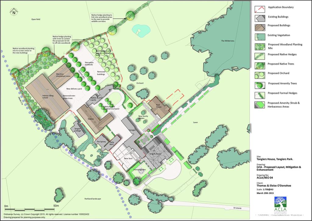
64
National Character Area 70 Melbourne Parklands
 Summary The are a landscape of rolling farmland, parkland and woodland on the northern flanks of the ridge between Burton upon Trent and Swadlincote. The land slopes down to the River Trent, which borders
INTRODUCTION. Land south of Bishopswood Lane, Tadley
 0 INTRODUCTION THE SITE Introduction Gladman Developments Ltd. has successfully invested in communities throughout the UK over the past 0 years, developing high quality and sustainable residential, commercial
Landscape Guidelines. Landscape type: Valley Pasture Character areas: Frome Valley Pasture Stour Valley Pasture. Landscape change
 Landscape type: Valley Pasture Character areas: Frome Valley Pasture Stour Valley Pasture The valley pasture landscape type is found along the lower reaches of the Stour and Frome, formed from alluvial
Warwickshire County Council. Upper and Lower Brailes. Landscape Study
 Warwickshire County Council Upper and Lower Brailes Landscape Study Produced by WCC Landscape Architects March 2016 Landscape Assessment of Potential Development Sites within the parish of Brailes 1.0
University Park, Worcester Non Technical Summary December 2011
 University Park, Worcester Non Technical Summary December 2011 Introduction UW Wrenbridge LLP, a Joint Venture Company of the University of Worcester and Wrenbridge Land Ltd (the Applicants ) intend to
INTRODUCTION CURRENT APPLICATION
 05/01805/FUL & 05/01807/LBC ERECTION OF A SINGLE DWELLING HOUSE WITH ANCILLARY ACCOMMODATION AT Flamingo Zoological Gardens, Olney Road, Weston Underwood FOR Mr A J Crowther (as amended by letter dated
Cotswolds AONB Landscape Strategy and Guidelines. June 2016
 Cotswolds AONB Landscape Strategy and Guidelines June 2016 Cotswolds AONB Landscape Strategy and Guidelines Introduction The evolution of the landscape of the Cotswolds AONB is a result of the interaction
Replacement Golf Course Facilities and Residential Development, Churston. Environmental Statement Non-Technical Summary
 Replacement Golf Course Facilities and Residential Development, Churston Environmental Statement Non-Technical Summary July 2011 Reproduced from the Ordnance Survey s map with the permission of the Controller
LANDSCAPE AND VISUAL ASSESSMENT
 Hertfordshire County Council LAND AT BALDOCK SITE 3 LANDSCAPE AND VISUAL ASSESSMENT JULY 2008 Jon Etchells Consulting Barn A, Dixies High Street Ashwell Herts SG7 5NT 01462 744662 HERTFORDSHIRE COUNTY
2014/0590 Reg Date 26/06/2014 Chobham
 2014/0590 Reg Date 26/06/2014 Chobham LOCATION: PROPOSAL: TYPE: APPLICANT: OFFICER: ASCOT PARK POLO CLUB, WESTCROFT PARK FARM, WINDLESHAM ROAD, CHOBHAM, WOKING, GU24 8SN Erection of a two storey detached
Statutory and Non-Statutory Designated Sites and Ecology
 Statutory and Non-Statutory Designated Sites and Ecology The National Planning Policy Framework considers the conservation and enhancement of the natural environment in chapter 11 paragraphs 109-119, where
Landscape Assessment CEUGP/SR9B
 Landscape Assessment CEUGP/SR9B TABLE OF CONTENTS 1 STUDY PHILOSOPHY... 3 2 GENERAL DESCRIPTION OF SITE... 4 3 LANDSCAPE THEMES... 8 TABLE OF FIGURES Table 1: Landscape... 5 Table 2: Landscape Themes...
Toddington Central Bedfordshire Stage 3 Green Belt Study December 2017
 Toddington Central Bedfordshire Stage 3 Green Belt Study December 2017 Site: ALP086 - Middle Lakes, Toddington Site size (ha): 2.83 Site: ALP086 - Middle Lakes, Toddington Site size (ha): 2.83 Site description
Rolling Wooded Pasture Lulworth Wooded Pasture Rempstone Wooded Pasture
 Landscape type: Character areas: Rolling Wooded Pasture Lulworth Wooded Pasture Rempstone Wooded Pasture The rolling wooded pasture landscape type is found around the margins of the Dorset Heaths. Although
SPG 1. * the northern and western sections which are open fields used for pasture and grazing;
 SPG 1 1.0 INTRODUCTION This development brief is based on the allocation of the Priors Hall site for employment and countryside recreational purposes in the Corby Borough Local Plan. The brief is intended
ROCHFORD LOCAL DEVELOPMENT FRAMEWORK: Sustainability Appraisal/ Strategic Environmental Assessment. Rochford Core Strategy Preferred Options Document
 ROCHFORD LOCAL DEVELOPMENT FRAMEWORK: Sustainability Appraisal/ Strategic Environmental Assessment Non Technical Summary Rochford Core Strategy Preferred Options Document October 2008 SUSTAINABILITY APPRAISAL
Change Paper / Date CAIRNGORMS NATIONAL PARK AUTHORITY
 Change Paper / Date CAIRNGORMS NATIONAL PARK AUTHORITY Title: Prepared by: REPORT ON CALLED-IN PLANNING APPLICATION FIONA MURPHY (PLANNING OFFICER DEVELOPMENT MANAGEMENT) DEVELOPMENT PROPOSED: REFERENCE:
Summary Note on Landscape and Visual Impact and Mitigation
 East Anglia TWO Offshore Windfarm Appendix 4.4 Summary Note on Landscape and Visual Impact and Mitigation Preliminary Environmental Information Volume 3 Document Reference EA2-DEVWF-ENV-REP-IBR- 000799_004
tributary farmland tributary farmland
 NORFOLK O R F O L K COAST C O A SAONB T A O NIntegrated B I n t elandscape g r a t e d L Guidance a n d s c a p e G u i d a n c e 1 Integrated landscape character MAP 23a - Landscape Character Type - Tributary
8.0 Design and Form of Development 43/
 42/ 8.0 Design and Form of Development 43/ Rothwells Farm, Golborne/ Development Statement Figure 7. Site Constraints Key 44/ Site Boundary 360 Bus Route/Stops Existing Trees Underground Water Pipe Sensitive
Schedule of Planning Applications Committee Date: 23 May Reference: 06/17/0726/F Parish: Hemsby Officer: Mr J Beck Expiry Date:
 Schedule of Planning Applications Committee Date: 23 May 2018 Reference: 06/17/0726/F Parish: Hemsby Officer: Mr J Beck Expiry Date: 22-05-2018 Applicant: Proposal: Site: Mr Gillett Change of use to the
LONGDEN VILLAGE DEVELOPMENT STATEMENT
 LONGDEN VILLAGE DEVELOPMENT STATEMENT 2017-2027 1 Longden Development Statement 2017-2027 15/01/18 1. Background 1.1 Longden Village Longden village is a very rural and traditional community first mentioned
Persimmon Homes Thames Valley Date received: 2 nd April week date(major): 2 nd July 2014 Ward: Nascot
: 2 nd July 2014 Ward: Nascot") PART A Report of: DEVELOPMENT MANAGEMENT SECTION HEAD Date of Committee: 26 th June 2014 Site address: Rounton, 28, Nascot Wood Road Reference Number: 14/00497/REM Description of Development: Reserved
PART A Report of: DEVELOPMENT MANAGEMENT SECTION HEAD Date of Committee: 26 th June 2014 Site address: Rounton, 28, Nascot Wood Road Reference Number: 14/00497/REM Description of Development: Reserved
Copyright Nigel Deeley and licensed for reuse under this Creative Commons Licence
 1 Copyright Nigel Deeley and licensed for reuse under this Creative Commons Licence Prepared by the Neighbourhood Plan Steering Group on behalf of Garway Parish Council with assistance from 2 Table of
WELCOME GYPSY LANE. Wider Site Location plan. Proposals for the development of LAND OFF FOXLYDIATE LANE WEBHEATH. Proposals for the development of
 WELCOME The developers are preparing an outline planning application for a residential led development and need the community s views in order to develop the proposals further WHAT IS PROPOSED? A high
Guidance for Wind Turbine Development in the Dorset Area of Outstanding Natural Beauty
 DRAFT January 2012 Guidance for Wind Turbine Development in the Dorset Area of Outstanding Natural Beauty Photo 1: Rew Manor Farm, West Dorset, chalk downland landscape (Planning application ref: 1/D/09/001280
Ward: West Wittering. Proposal Change of use from public highway pavement to residential garden use.
 Parish: West Wittering Ward: West Wittering WW/17/03295/FUL Proposal Change of use from public highway pavement to residential garden use. Site Izora 1 Watersedge Gardens West Wittering PO20 8RA Map Ref
DEVELOPMENT MANAGEMENT REPORT
 ITEM A08-1 DEVELOPMENT MANAGEMENT REPORT TO: BY: DATE: DEVELOPMENT: SITE: WARD: APPLICATION: APPLICANT: Development Management Committee Development Manager Proposed live/work unit in connection with existing
Guidance for Wind Turbine Development in the Dorset AONB
 Photo 1: Rew Manor Farm, West Dorset, chalk downland landscape (Planning application ref: 1/D/09/001280 1 ) Scale & siting: 12m to hub / 16m to blade tip. A well sited small scale turbine, grouped with
LANDSCAPE AND VISUAL ASSESSMENT
 Hertfordshire County Council LAND AT BALDOCK SITE 2 LANDSCAPE AND VISUAL ASSESSMENT JULY 2008 Jon Etchells Consulting Barn A, Dixies High Street Ashwell Herts SG7 5NT 01462 744662 HERTFORDSHIRE COUNTY
Parish of Repton NEIGHBOURHOOD DEVELOPMENT PLAN
 Parish of Repton NEIGHBOURHOOD DEVELOPMENT PLAN BASIC CONDITIONS STATEMENT December 2018 CEF 4 Legal Requirements This statement has been produced by the NDP Working Group on behalf of Repton Parish Council
PANSHANGER QUARRY, Hertfordshire
 PANSHANGER QUARRY, Hertfordshire Proposed enhanced restoration of Phases F & H Briefing Note 1 March 2015 INERT (INACTIVE) RESTORATION MATERIALS, CONTROLS AND OPERATIONS 1 Introduction This briefing note
MATURE SUBURBS RESIDENTIAL DEVELOPMENT GUIDELINES
 MATURE SUBURBS RESIDENTIAL DEVELOPMENT GUIDELINES DRAFT FEBRUARY 2005 BIRMINGHAM CITY COUNCIL 1 Introduction Mature Suburbs Residential Development Guidelines - Interim Supplementary Planning Advice -
Welcome to our Public Consultation
 About our development This exhibition gives you the chance to view and comment on our emerging plans for a proposed residential development located on land to the West of Alwyn Road, Rugby. Welcome to
Planning and Regulatory Committee 20 May Applicant Local Councillor Purpose of Report
 Planning and Regulatory Committee 20 May 2014 7. APPLICATION FOR PLANNING PERMISSION FOR THE CARRYING-OUT OF DEVELOPMENT PURSUANT TO PLANNING PERMISSION REFERENCE NUMBER 603451 DATED 28 FEBRUARY 2007 WITHOUT
PLANNING COMMITTEE DATE: 07/09/2015 REPORT OF THE SENIOR MANAGER PLANNING AND ENVIRONMENT SERVICE CAERNARFON. Number: 4
 Number: 4 Application Number: C15/0034/37/LL Date Registered: 21/05/2015 Application Type: Full - Planning Community: Llanaelhaearn Ward: Llanaelhaearn Proposal: Location: Summary of the Recommendation:
Viewpoint 1. Location: View from Murch Road on the north eastern boundary of Application Site. Viewing south / southwest.
 Application Site (eastern field) Former site of St. Cyres Lower School Murch Road 1 Location: View from Murch Road on the north eastern boundary of Application Site. Viewing south / southwest. Baseline
Wyvern Park Skipton Environmental Statement. Non-technical Summary - April 2015
 Wyvern Park Skipton Environmental Statement Non-technical Summary - April 2015 BWB Consulting Ltd Whitehall Waterfront 2 Riverside Way Leeds LS1 4EH Telephone: +44(0)113 233 8000 Copyright This Report
INTRODUCTION. Land off Beresford Road, Holt. Introduction. Site Description. Housing Need. Why is the site suitable for development?
 01 INTRODUCTION Introduction Thank you for taking the time to view this public exhibition and find out more about Gladman Development s latest proposals to develop a new sustainable community of up to
DUNSFOLD NEIGHBOURHOOD PLAN Site Selection Policies
 DUNSFOLD NEIGHBOURHOOD PLAN Site Selection Policies The criteria for assessing sites for future housing and business development in Dunsfold are set out below. (Development criteria, covering what it is
Statement of Community Involvement LAND OFF SOUTHDOWN ROAD HORNDEAN, HAMPSHIRE
 LAND OFF SOUTHDOWN ROAD HORNDEAN, HAMPSHIRE CONTENTS Page 1. Introduction 3 2. Pre-application Discussions 4 3. The Consultation Process 5 4. Consultation Feedback 7 5. Responses to Consultation Feedback
To secure a Green Belt around Cambridge whose boundaries are clearly defined and which will endure for the plan period and beyond.
 4. GREEN BELT OBJECTIVES GB/a GB/b GB/c GB/d To secure a Green Belt around Cambridge whose boundaries are clearly defined and which will endure for the plan period and beyond. To maintain the purposes
Site ref: AS06 Site Name or Address: Murreys Court, Agates Lane
 Site ref: AS06 Site Name or Address: Murreys Court, Agates Lane Proposed Land Use: Total Site Area (Ha): Housing 1.85 Ha Description: It is understood that the owner has no plans to dispose of the site
LANDSCAPE AND VISUAL IMPACT ASSESSMENT
 HARE STREET ROAD BUNTINGFORD LANDSCAPE AND VISUAL IMPACT ASSESSMENT Prepared by ACD Chartered Landscape Architects for Written By: SJD Checked By: JS Date: Document File Ref: TWNT18550lvia Revision: A-
Wind energy development in the South Pennines landscape
 Wind energy development in the South Pennines landscape Programme for today Background Policy context South Pennines landscape Impacts of wind energy development The South Pennines Wind Energy Landscape
WELCOME. Olney Road, Lavendon INTRODUCTION. The Site. The Application. The Need for Housing. A Sustainable Location LAVENDON TURVEY OLNEY ROAD
 0 WELCOME INTRODUCTION Gladman Developments Ltd have successfully invested in communities throughout the UK over the past 0 years, developing high quality and sustainable residential, commercial and industrial
AT MOONS YARD, GROVE ROAD, SELLING, FAVERSHAM PLANNING STATEMENT DHA REF: JAC/MG/9967
 DEMOLITION OF EXISTING COMMERCIAL BUILDINGS, REMOVAL OF THE EXISTING HARD SURFACE AREAS AND THE ERECTION OF 5 No DWELLINGS WITH AMENITY SPACE, PADDOCKS, PARKING, ACCESS AND LANDSCAPING AT MOONS YARD, GROVE
LandscapeCollective. Dorothy House, Winsley. Landscape and Visual Appraisal. On behalf of Dorothy House Hospice Care.
 Project Ref: LC/00043 Project Number: 00043A Authored by: Stuart Hocking Reviewed by: Stephen Wadsworth Date: August 2016 Document version P:\Landscape Collective\Admin\Templates\LC Report Template Jan
M7 Naas to Newbridge Bypass Upgrade Scheme. Landscape and Visual Impact Assessment Brief of Evidence
 M7 Naas to Newbridge Bypass Upgrade Scheme Landscape and Visual Impact Assessment Brief of Evidence Presented by Richard Butler, Cunnane Stratton Reynolds Landscape Architect: BL Arch (University of Pretoria,
SOUTH CAMBRIDGESHIRE DISTRICT COUNCIL. Executive Director (Operational Services) Corporate Manager (Planning and New Communities)
 Corporate Manager (Planning and New Communities)") SOUTH CAMBRIDGESHIRE DISTRICT COUNCIL REPORT TO: Planning Committee 12 January 2011 AUTHOR/S: Executive Director (Operational Services) Corporate Manager (Planning and New Communities) Notes: S/1848/10
SOUTH CAMBRIDGESHIRE DISTRICT COUNCIL REPORT TO: Planning Committee 12 January 2011 AUTHOR/S: Executive Director (Operational Services) Corporate Manager (Planning and New Communities) Notes: S/1848/10
SETTLEMENT ASSESSMENT PROFORMA
 SETTLEMENT ASSESSMENT PROFORMA Surveyors(s):Clare Sheridan Character Area: Park Estate = Midland Rd, Severn Rd, Festival Rd, Park Rd, Willow Rd, Rylands Rd. Date: Feb Weather: cloudy Look through all the
Derry City and Strabane District Council Planning Committee Report
 Derry City and Strabane District Council Planning Committee Report COMMITTEE DATE: 23 rd March 2016 APPLICATION No: APPLICATION TYPE: PROPOSAL: LOCATION: APPLICANT: LA11/2015/0395/F Residential Development
INTRODUCTION. Land West of Main Road, Stanton Harcourt THE SITE. Why is the Site Suitable for Development?
 0 INTRODUCTION THE SITE Application Boundary Gladman Developments Ltd has successfully invested in communities throughout the UK over the past 0 years, developing high quality and sustainable residential,
3. Neighbourhood Plans and Strategic Environmental Assessment
 1. Introduction This report sets out a draft Screening Determination for the Preston Parish Council s Neighbourhood Plan and has been prepared by rth Hertfordshire District Council. The purpose of the
5 Gratton Terrace London NW2 6QE. Reference: 17/5094/HSE Received: 4th August 2017 Accepted: 7th August 2017 Ward: Childs Hill Expiry 2nd October 2017
 Location 5 Gratton Terrace London NW2 6QE Reference: 17/5094/HSE Received: 4th August 2017 Accepted: 7th August 2017 Ward: Childs Hill Expiry 2nd October 2017 Applicant: WSD (Gratton) Ltd Proposal: The
Genex Kidston Connection Project: Draf t Environmental Assessment Report Powerlink Queensland
 : Draf t Environmental Assessment Report Powerlink Queensland Chapter 14 \\autsv1fp001\projects\605x\60577456\6. Draft Docs\6.1 Reports\4. Compiled draft 17 September\Covers\Chapters\Ch 14.docx Rev ision
Neighbourhood Planning Local Green Spaces
 Neighbourhood Planning Local Green Spaces Introduction... 2 1. Why green space is important... 4 2. Neighbourhood plans and green space... 6 3. Evidence... 8 Statutory designations... 9 Green space audit...
WELCOME. Land North of STEVENAGE. We would like to thank you for attending our public exhibition today.
 WELCOME We would like to thank you for attending our public exhibition today. The purpose of this event is to share our proposals and hear your thoughts on our ideas. Members of the project team are on
NON-TECHNICAL SUMMARY
 Proposed Sand and Gravel Extraction and Associated Processing Operations with Restoration to a Mixture of Agriculture and Nature Conservation including Areas of Shallow Water at Hedgeley, Northumberland
PDP DESIGN & ACCESS STATEMENT
 PDP The Planning & Design Partnership Planning.. Architecture.. Interiors.. Landscape The Chicory Barn Studio, The Old Brickyards, Moor Lane, Stamford Bridge York, The East Riding Of Yorkshire, YO41 1HU.
LANDSCAPE CHARACTER ASSESSMENT
 THE COUNTY DURHAM LANDSCAPE CHARACTER ASSESSMENT FOREWORD The landscape of County Durham is one of great contrast and diversity. From the North Pennines in the west to the Durham Coast in the east it contains
3(iv)(b) TCP/11/16(29)
(b) TCP/11/16(29)") 3(iv)(b) TCP/11/16(29) TCP/11/16(29) Planning Application 09/02229/AML Erection of a dwellinghouse, garage with upper floor accommodation and stables (Approval of Matters Specified by Conditions) at land
3(iv)(b) TCP/11/16(29) TCP/11/16(29) Planning Application 09/02229/AML Erection of a dwellinghouse, garage with upper floor accommodation and stables (Approval of Matters Specified by Conditions) at land
Ground Floor Flat 15 Redbourne Avenue London N3 2BP
 Location Ground Floor Flat 15 Redbourne Avenue London N3 2BP Reference: 17/4160/FUL Received: 28th June 2017 Accepted: 29th June 2017 Ward: West Finchley Expiry 24th August 2017 Applicant: Proposal: Mr
Longhorsley Neighbourhood Plan
 Site Assessment 1. The availability of the site 1.1 Is the land owner willing for their site to be made available for development? 1.2 If yes, do you have any written evidence to back this up? Planning
Grantham Southern Quadrant Link Road Environmental Statement
 Grantham Southern Quadrant Link Road Environmental Statement Non Technical Summary Introduction Lincolnshire County Council (LCC) is submitting a planning application for the proposed implementation of
DRAFT CONSERVATION AREA APPRAISAL CHAILEY GREEN DESIGNATED
 DRAFT CONSERVATION AREA APPRAISAL CHAILEY GREEN DESIGNATED 16.06.76 DRAFT CHAILEY GREEN CONSERVATION AREA APPRAISAL 1 SUMMARY 1.1 Key Positive Characteristics 1.2 Recommendations 2 INTRODUCTION 2.1 The
BARRATT HOMES September 2017 LAND OFF ENGINE ROAD NAILSEA LANDSCAPE AND VISUAL IMPACT ASSESSMENT
 0 CONTENTS PAGE 1.0 INTRODUCTION 2 2.0 DESCRIPTION OF DEVELOPMENT & LANDSCAPE STRATEGY 4 3.0 BASELINE SURVEY AND ASSESSMENT 5 4.0 ASSESSMENT OF LANDSCAPE EFFECTS 11 5.0 ASSESSMENT OF VISUAL EFFECTS 17
BROADHEMBURY DESIGN STATEMENT
 BROADHEMBURY DESIGN STATEMENT As drawn up by Broadhembury Parish Council during the development of a Parish Plan and adopted at its meeting on 17 th May 2010 BROADHEMBURY DESIGN STATEMENT Contents Introduction
CA//17/02777/FUL. Scale 1:1,250. Planning Services Canterbury City Council Military Road Canterbury Kent CT1 1YW
 O CA//17/02777/FUL Scale 1:1,250 Map Dated: 15/03/2018 Planning Services Canterbury City Council Military Road Canterbury Kent CT1 1YW AGENDA ITEM NO 16 PLANNING COMMITTEE APPLICATION NUMBER: SITE LOCATION:
A payment of 1080 is due in this instance, for a meeting and follow up written response, and will be made by card over the phone.
 JPPC ref: AG/6002 18 th September 2014 Planning Services Vale of White Horse District Council Benson Lane Crowmarsh Gifford Wallingford OX10 8ED Dear Sir/Madam REQUEST FOR PRE-APPLICATION ADVICE RE: RESIDENTIAL
49 Broughton Avenue London N3 3EN
 Location 49 Broughton Avenue London N3 3EN Reference: 17/3448/RCU Received: 30th May 2017 Accepted: 1st June 2017 Ward: Finchley Church End Expiry 27th July 2017 Applicant: Mr P Atwal Proposal: Erection
THAMES VALLEY PARK & RIDE
 REPORT N O 70012699_V1 THAMES VALLEY PARK & RIDE LANDSCAPE AND VISUAL APPRAISAL PUBLIC JANUARY 2016 THAMES VALLEY PARK & RIDE LANDSCAPE AND VISUAL APPRAISAL Wokingham Borough Council V1 Public Project
APP/G1630/W/15/
 Appeal Decision Site visit made on 20 October 2015 by William Fieldhouse BA (Hons) MA MRTPI an Inspector appointed by the Secretary of State for Communities and Local Government Decision date: 20 November
REFERENCE: B/03745/12 Received: 02 October 2012 Accepted: 05 October 2012 WARD(S): Totteridge Expiry: 30 November 2012.
: Totteridge Expiry: 30 November 2012.") LOCATION: 15A Pyecombe Corner, London, N12 7AJ REFERENCE: B/03745/12 Received: 02 October 2012 Accepted: 05 October 2012 WARD(S): Totteridge Expiry: 30 November 2012 Final Revisions: APPLICANT: PROPOSAL:
LOCATION: 15A Pyecombe Corner, London, N12 7AJ REFERENCE: B/03745/12 Received: 02 October 2012 Accepted: 05 October 2012 WARD(S): Totteridge Expiry: 30 November 2012 Final Revisions: APPLICANT: PROPOSAL:
- - - Key Characteristics
 S23 Dyffryn Dysynni Reproduced from the Ordnance Survey map with the permission of Ordnance Survey on behalf of the Controller of Her Majesty s Stationery Office, Crown copyright Licence No. 100023387
Longbridge Town Centre Phase 2 Planning Application
 Longbridge Town Centre Phase 2 Planning Application Non-Technical Summary of the Environmental Statement December 2013 Introduction A full application for Planning Permission has been submitted to Birmingham
2015/0291 Reg Date 13/04/2015 Parkside
 2015/0291 Reg Date 13/04/2015 Parkside LOCATION: PROPOSAL: TYPE: APPLICANT: OFFICER: BROOK GREEN & TINYBROOK, WAVERLEY CLOSE, CAMBERLEY, GU15 1JH Outline application for the erection of two blocks of flats
Land off Arbour Close and Cotswold Edge Mickleton, Gloucestershire. Design and Access Statement Mickleton, Gloucestershire
 Land off Arbour Close and Cotswold Edge Contents INTRODUCTION Vision SITE DESCRIPTION The site Technical Assessment ASSESSMENT & EVALUATION Constraints and opportunities SITE CONTEXT Pattern of Development
Development in the Green Belt
 Supplementary Planning Document: Development in the Green Belt Consultation Draft February 2013 Local Development Framework How to comment This document was published on 21st March 2013 and comments should
SITE ASSESSMENT FORM
 Appendix 2 SITE ASSESSMENT FORM 1. Site information Settlement: Colwall Main Village Site name: SITE 1 Part of vacated Colwall school site and adjacent area Site address: Walwyn Road Site area (hectares):
North York Moors National Park Authority Planning Committee
 Item 8 North York Moors National Park Authority Planning Committee 12 December 2013 Consultation from Redcar and Cleveland Borough Council on proposed Wind Farm at Bank Field Guisborough 1. Purpose of
CHAPTER 18 - Strategy Area: Dundry and River Valleys
 This south-eastern part of the Community Forest is a complex area with a wide variety of different landscapes close together, including the Chew Valley, the southern part of the Avon Valley and the eastern
Introduction. Welcome to this consultation regarding the draft redevelopment proposals for the former CeramTec factory on Sidmouth Road, Colyton.
 Introduction Welcome to this consultation regarding the draft redevelopment proposals for the former CeramTec factory on Sidmouth Road, Colyton. We are currently considering options for the mixed-use redevelopment
Development in the setting of the Cotswolds AONB
 COTSWOLDS CONSERVATION BOARD POSITION STATEMENT Development in the setting of the Cotswolds AONB.1. Introduction Areas of Outstanding Natural Beauty (AONBs) are designated by the Government for the purpose
Proposed Residential Development at Church Stile Farm in Cradley, Herefordshire. Hazel Dormouse Surveys
 Proposed Residential Development at Church Stile Farm in Cradley, Herefordshire A report to: Terra Strategic BSL Strategic Ltd. 2 The Courtyard 707 Warwick Road Solihull B91 3DA By: Udall-Martin Associates
Lower Sensitivity. VS Classification Level 2: Exposed Upland/Plateau
 S04 Moel Hebog Reproduced from the Ordnance Survey map with the permission of Ordnance Survey on behalf of the Controller of Her Majesty s Stationery Office, Crown copyright Licence No. 100023387 Location
BREEDON NORTHERN LIMITED
 Non Technical Summary CONTENTS 1 INTRODUCTION... 1 2 SITE DESCRIPTION... 1 3 DESCRIPTION OF THE DEVELOPMENT... 6 4 NEED FOR THE DEVELOPMENT... 8 5 KEY ISSUES CONSIDERED IN THE ENVIRONMENTAL IMPACT ASSESSMENT...
LANDSCAPE PLANNING ECKLAND LODGE REDDITCH ROAD CRIBBS CAUSEWAY YEW TREE HILL LUBENHAM TENBURY WELLS
 We offer our expertise at all stages of the landscape planning and environmental assessment process, including strategic landscape assessment or capacity studies to determine the scale of development opportunities;
East Harptree Landscape & Character Assessment
 East Harptree Landscape & Character Assessment Produced by East Harptree Parish Council in consultation with local residents September 2014 Contents The Parish of East Harptree: Objective Introduction
Land East of Cromwell Lane
 Land East of Cromwell Lane VISION DOCUMENT AUGUST 2016 The proposals for Land East of Cromwell Lane will be defined by existing landscape features, ensuring that the development offers a quality place
Settlement Boundaries Methodology North Northumberland Coast Neighbourhood Plan (August 2016)
") Introduction This background paper sets out a methodology for the definition of settlement boundaries in the North Northumberland Coast Neighbourhood Plan. The neighbourhood plan is planning positively
Introduction This background paper sets out a methodology for the definition of settlement boundaries in the North Northumberland Coast Neighbourhood Plan. The neighbourhood plan is planning positively
South Whitehaven, Cumbria EIA
 South Whitehaven, Cumbria EIA Environmental Statement - Non Technical Summary June 2013 in association with 1. Introduction Story Homes is applying to Copeland Borough Council (CBC) for a new residential
Salhouse Parish Council, 11 th November Response to Planning Application
 Salhouse Parish Council, 11 th November 2013 Response to Planning Application 20131408 Summary Salhouse Parish Council (SPC) has received via Broadland District Council a Planning Application for a 5MWp
Environmental and Landscape Mapping
 Environmental and Landscape Mapping In support of the Calveley Neighbourhood Plan November 2016 Project Name and Number: Calveley Neighbourhood Plan 16-025 Document Name and Revision: Environmental and
Reference: 16/1234/HSE Received: 25th February 2016 Accepted: 2nd March 2016 Ward: High Barnet Expiry 27th April 2016
 Location 7 Sunset View Barnet EN5 4LB Reference: 16/1234/HSE Received: 25th February 2016 Accepted: 2nd March 2016 Ward: High Barnet Expiry 27th April 2016 Applicant: Proposal: Mr & Mrs Peter & Anny Woodhams
1 The development hereby permitted shall be carried out in accordance with the following approved plans:
 Location 59 Greenway Close London N20 8ES Reference: 16/00011/HSE Received: 30th December 2015 Accepted: 7th January 2016 Ward: Totteridge Expiry 3rd March 2016 Applicant: Mr Ankit Shah Proposal: Part
PLANNING COMMITTEE REPORT
 PLANNING COMMITTEE REPORT TO: BY: Planning Committee South Head of Development DATE: 19 December 2017 DEVELOPMENT: SITE: WARD: APPLICATION: APPLICANT: Conversion of existing water storage reservoir to
 DHA ENVIRONMENT LAND TO THE REAR OF WARDSDOWN HOUSE, FLIMWELL LANDSCAPE AND VISUAL ASSESSMENT JE/11291 Peer Group plc Contents 1 INTRODUCTION AND METHODOLOGY... 4 1.1 General... 4 1.2 Methodology... 4
Proposal: Proposed new access road. The application site is Council owned land and the decision level is at Planning and Licensing Committee.
 Reference: 16/01492/FUL Ward: Warley Site: Lion Lodge South The Avenue Warley Essex CM13 3RZ Proposal: Proposed new access road Plan Number(s): 1:1250 LOCATION PLAN; MB.DJA 1 OF 1; Applicant: Mr M Bryan
Land at BROOK STREET PROPERTIES TENCREEK FARM, LISKEARD. Environmental Statement: Non-Technical Summary
 BROOK STREET PROPERTIES TENCREEK FARM, LISKEARD Land at Environmental Statement: Non-Technical Summary Introduction Brook Street Properties is applying to Cornwall Council for outline planning permission