Town of Whitby Waterfront Parks and Open Space Master Plan Final Report, January 2016
|
|
|
- Annabelle Howard
- 5 years ago
- Views:
Transcription

1 CMS Attachment #1 Town of Whitby Waterfront Parks and Open Space Master Plan Final Report, January 2016
2
3 Table of Contents Waterfront Master Plan Study Overview i Introduction 1 Overall Waterfront Vision and Guiding Principles 2 Overall Waterfront Opportunities and Challenges 4 Parks and Open Space Master Plan Approach 7 Part Two Waterfront Precincts Concepts 10 Precinct 1: Cranberry and Lynde Marshes 13 Precinct 2: Lynde Shores 25 Precinct 3: Port Whitby Community 32 Precinct 4: Pringle Creek 51 Precinct 5: (Former) Dupont and Gerdau Shoreline 61 Precinct 6: Corbett Creek Marsh 68 Part Three Implementation 77 Detailed Order of Magnitude Costing 87 This Master Plan was developed by Brook Mcllroy Inc., (in association with SENES Consultants Ltd. & Ipsos Reid) with oversight and input from Staff of all departments within the Town of Whitby.
4 Whitby Waterfront Parks and Open Space Master Plan Project Overview The Whitby Waterfront Parks and Open Space Master Plan provides a comprehensive strategy over the next 20 years to enhance the waterfront s unique natural, heritage, cultural, and recreational features. This Plan has been developed through an in depth analysis of waterfront lands and its assets, and presents strategic goals and directions to achieve the vision of the waterfront The study consisted of the following three phases: 1. Part One Background Review and Data Collection; 2. Part Two Site Specific Analysis and Draft Precinct Concept Plans; and 3. Part Three Implementation Considerations and Final Waterfront Parks and Open Space Master Plan. Public input has been central in all three project phases to the development of the Waterfront Parks and Open Space Master Plan. Throughout the process, there have been opportunities for the public to review work and provide feedback, either by attending a workshop, an open house or by providing direct feedback via and mail submissions. Stakeholder feedback opportunities including workshops and interviews were also conducted throughout the course of the planning and design process. Feedback received assisted the team in understanding the community s priorities in encouraging positive change throughout the waterfront. Part One - Backgound Review and Data Collection I Corporation of the Town of Whitby The purpose of Phase One was to gather and review background information, understand the Town of Whitby s waterfront parks and open space issues, and develop a vision to guide the creation of a high level, overall waterfront concept. A comprehensive Town-wide telephone survey was also carried out. The survey contained a series of targeted questions, designed to gauge the level of interest and support for the Waterfront Parks and Open Space Master Plan, by the general public, while determining public priorities and preferred directions. The results of the survey concluded that Whitby s waterfront is of significant importance to local residents, and that efforts should be made to protect existing natural features while expanding and broadening waterfront activities. A summary of these findings is provided in the attached Appendix. Part Two - Site Specific Analysis The second phase of the study focussed on further analyzing the issues, opportunities, constraints and strategic directions in each precinct. This information was used to develop draft Concept Plans

5
6 III Corporation of the Town of Whitby North m
7 and recommendations for each precinct, which were refined based on consultation with Town Council, the Advisory Committee, external stakeholders, and the public. Key elements of each Precinct are as follows: (For further information and detailed discussions of each precinct, please refer to Section 2). Precinct 1 Cranberry and Lynde Marshes: The Cranberry and Lynde Marshes Precinct would become a Region-wide passive destination for wildlife learning and observation owned and managed by the Central Lake Ontario Conservation Authority (CLOCA), while ensuring continued conservation of the Cranberry and Lynde Creek Marsh Provincially Significant Wetlands and adjacent habitats. The concept design for the precinct includes an improved Waterfront Trail, improved boardwalks, nature interpretation stations, bird watching platforms for nesting and migrating birds, recommended viewing and picnic locations, and a new pedestrian/bicycle trail connection to the north end of the Lynde Shores Conservation Area. Key redevelopment opportunities in Precinct 1 include improvements to both the Halls Road South Waterfront Trail and Victoria Street West. Precinct 2 Lynde Shores: The Lynde Shores Precinct would promote the recent and developing neighbourhoods, industrial and commercial uses and the Ontario Shores Centre for Mental Health Sciences as a mixed-use waterfront neighbourhood. The concept design recommends improved pedestrian and cyclist connections to the Waterfront Trail, Eggert Parkette and Portage Park and other open spaces. Themed nature viewing areas would highlight the flora and fauna (plant-life and animals) of the Lynde Creek Marsh and Lake Ontario. The master plan for Ontario Shores envisages a connected, community-oriented institution that integrates with its unique lakefront setting and the surrounding neighbourhood. Precinct 3 Port Whitby Community: The Port Whitby Community Precinct would build on its significant role as the heart of the waterfront with over 50 hectares of parks and community facilities, the Port Whitby Marina and Whitby Yacht Club, Station Gallery, Abilities Centre, Iroquois Park Sports Centre and the Whitby GO Station. The Port Whitby Community Precinct would become a vibrant and animated waterfront centre, with an existing transit node (GO Station). The area has the potential to expand into a fully accessible tourism node for both the Town and the Region. The precinct is proposed to provide commercial, cultural, and recreational amenities and improved access to Victoria Fields, open spaces, Iroquois Beach, and other areas of the waterfront. The concept design for the precinct includes a new urban waterfront park design for Victoria Fields, improvements to Iroquois Beach, an improved Waterfront Trail, secondary trails, improved street and pedestrian connections to parks and open spaces and connections across the GO / Highway 401 corridor. A view of the existing dock within the Lynde Shores Conservation Area. A view of Iroquois Beach, looking west toward the Lynde Shores Conservation Area. Brook McIlroy Inc., SENES Consultants Ltd., and Ipsos Reid IV

8 V Corporation of the Town of Whitby
9 Precinct 4 Pringle Creek: The Pringle Creek Precinct would become a local and regional destination among its surrounding neighbourhoods, large industrial sites and Provincially Significant Wetlands located at the mouth of Pringle Creek. The Pringle Creek design focuses largely on providing greater access to Rotary Sunrise Lake Park through improvements to the Waterfront Trail, the creation of a secondary trail between Victoria and Water Streets, and improvement of the Heydenshore Pavilion for special events. The concept design proposes preserving and enhancing the old Pumphouse as an open air pavilion and cultural feature for programming and special activities. In addition to improved access to Kiwanis-Heydenshore Park and the waterfront, the concept includes secondary multi-use trails, improved connections to parks and open spaces, recommended viewing locations, streetscape improvements, improved parking areas, park improvements and expansions, and enhancements to the composition of the shoreline at Kiwanis- Heydenshore Park. Precinct 5 (Former) Dupont and Gerdau Shoreline: The (Former) Dupont and Gerdau Shoreline Precinct would focus its role away from the surrounding industrial lands and extend the beauty of its remote, natural and peaceful shoreline. The lake front lands are a local and largely naturalized destination offering improved access to local parks and would provide additional open spaces through the eastward expansion of Kiwanis-Heydenshore Park, as well as improved access to the waterfront. The concept for the precinct includes an improved Waterfront Trail, secondary multi-use trails, recommended viewing locations, improved parking areas, education opportunities, and park improvements and expansions. Precinct 6 Corbett Creek Marsh: The Corbett Creek Marsh Precinct is the second largest environmentally sensitive area on the waterfront and includes Intrepid Park and approximately 40 hectares of open space. The concept plan builds on the importance of the parkland as a defining entry point to the Town and to Whitby s waterfront. Nature viewing to Corbett Creek Marsh and the potential introduction of memorial gardens dedicated to the historic significance of Camp X offers improved access to Intrepid Park as well as the waterfront. The concept for the precinct includes an improved Waterfront Trail, secondary multi-use trails, pedestrian and cyclist gateway markers at key locations, bridge improvements, education opportunities, park improvements, recommended viewing locations, and a new parking area. View of the Lake Ontario waterfront from Kiwanis Heydenshore Park. Camp X memorial within Corbett Creek Marsh Precinct. Brook McIlroy Inc., SENES Consultants Ltd., and Ipsos Reid VI
10 Part Three - Implementation Considerations Preliminary capital costs estimates for each redevelopment site, as well as preliminary maintenance cost estimates, were developed in Part Three of the study. The total cost of the project is estimated to be $25,508,000, which would be executed in four phases. Redevelopment and site enhancement priorities for each phase are as follows: (For more information on overall project implementation and costing please refer to Part 3, Implementation, page 77.) Phase One (0-5 Years) Implementation Phase One priorities includes the redevelopment of the Pumphouse and Victoria Fields at the later end of the Phase One. The Pumphouse is a significant heritage feature that would be redeveloped in Upon the redvelopment of Victoria Fields, it is recommended the name of the park be changed to Victoria Waterfront Park to celebrate the transformation into a destination urban park. The estimated cost of $7,761,000, would include enhancements to the park to create a multitude of activities and uses. Kiwanis-Heydenshore Park is heavily used in the summer months and the redevelopment of Victoria Waterfront Park would address the growing demand and would provide increased options and opportunities for use. Phase Two (6-10 Years) Implementation The expansion of Kiwanis-Heydenshore Park, located in Precinct 4 and Precinct 5, is the Town s next redevelopment priority. The park is currently one of Whitby s main waterfront destinations and frequented by many users during summer months. The project is estimated to cost approximately $4,035,000. This figure includes the passive or active field space, potential retrofit of the playground, if required, and the addition of new trees and benches. Additional facilities such as the special events centre, and volleyball courts proposed within the plan may be implemented in later phases at an additional cost. Additional improvements to Kiwanis-Heydenshore Park may also include the potential redevelopment of the Heydenshore Pavilion and enhancement to the adjacent parking area. These additional enhancements would require a Parks Master Plan and detailed design drawings to further outline the level of phasing and development of the park. Phase Three (11-15 Years) Implementation VII Corporation of the Town of Whitby Improvements to Iroquois Beach and Gateway and wayfinding markers are priorities in Phase Three. Iroquois Beach will be redeveloped in Phase Three at an estimated cost of $2,072,000, which will be focussed on increasing visibility, accessibility and usage of this area. Educational nodes, viewing area, and gateway and wayfinding markers will also be implemented throughout the entire waterfront to facilitate improved access and visibility, at an estimated cost of $545,000. Phase Four (16-20 Years) Implementation Intrepid Park would be a priority in Phase Four. Potential improvements to Intrepid Park may include a new memorial garden, planting areas and educational and bird watching opportunities, improvements to enhance pedestrian accessibility, visual appeal, and connectivity at an estimated cost of $2,900,000.

11 Brook McIlroy Inc., SENES Consultants Ltd., and Ipsos Reid VIII

12 1.0 Introduction 1.1 Plan Area The Whitby Waterfront is situated at the southern terminus of downtown Whitby and is roughly bounded by Lake Ontario to the south, Highway 401 to the north, the Town of Ajax to the west, and the City of Oshawa to the east. The waterfront covers an area of approximately 16.6 square kilometers and contains over 370 hectares of conservation lands, over 100 hectares of passive open space, and over 60 hectares of parkland and community facilities. The waterfront shoreline is 11 kilometers in length, the majority of which is under public ownership or lease. Several of Whitby s premier destination parks and open spaces are located here and serve local residents and tourists originating from the Greater Toronto Area. From birding, boating, cycling, and walking to sightseeing, the waterfront offers recreational opportunities for a variety of users. In the future, through further development, recreational opportunities would be expanded and provided to people of all ages, interests, and abilities. Major community facilities located at the waterfront include: Port Whitby Marina with 420 boat slips; Iroquois Park Sports Centre, which is Canada s largest municipal indoor recreation complex and receives over 2.0 million annual visits; the Station Gallery, which is operated by a not for profit arts organization and receives over 20,000 annual visits; and the 10,513 square metre Abilities Centre, which is fully accessible recreation and athletic facility. 01 Corporation of the Town of Whitby NORTH not to scale Aerial image highlighting the boundaries of the study area.

13 1.2 Overall Waterfront Vision and Guiding Principles Vision Statement Bringing People to the Waterfront - As a unique coastal land form, the Whitby Waterfront is among the Town s most valuable resources for residents of Whitby, the Region of Durham and the surrounding Greater Golden Horseshoe. Therefore, the Whitby Waterfront shall be a vital destination which balances and protects its significant natural, cultural and built features, while providing a variety of attractions for persons of all ages and abilities. Guiding Principles Balance - Achieving a balance of active park uses, passive open space uses, and natural area preservation is a top priority. This would result in a diverse range of opportunities and programs for residents, workers, students, visitors and the community at large while determining what is appropriate for the natural environment. Environmentally Responsible - The environment shall be a top consideration while planning for a renewed waterfront. Several opportunities for environmental stewardship exist along the waterfront including preserving wildlife habitat, protecting and enhancing the shoreline and waterways where possible, and incorporating green building principles and management practices. Such opportunities shall be addressed through recommendations that are supportive of CLOCA s management plan, and will conform to Section 5.2 of the Official Plan, which outlines objectives regarding environmental management. A view of Cranberry Marsh. Engaging the Community - Maintaining an open, consultative process during the study was essential to capture the different visions for the waterfront. Council s Goals ( ) provides direction to create a community-based plan on how the waterfront should be used and developed. Fostering Partnerships - There are many businesses, non-profit groups, sport and recreation groups, and government agencies with interests on the waterfront. The Plan explores opportunities for the Town to strengthen partnerships with these groups to improve capital investment and programming at the waterfront. Financially Feasible - The Town s waterfront strategy must be financially feasible. All development concepts and recommendations made shall consider the capital and operating costs to the Town. The Plan makes recommendations to generate revenues, where possible. Accessible - Eliminating barriers is an important responsibility of the Town of Whitby. Waterfront parks and open spaces should be accessible to people of all ages and abilities, including children, seniors, and persons with disabilities. All development along the Whitby Waterfront shall conform to the policies outlined in the Section of the Official Plan, which encourages accessibility and connectivity of the waterfront. Connected - The waterfront is a focal point in the Town and access to the area should View of boats entering the Port Whitby Marina. Brook McIlroy Inc., SENES Consultants Ltd., and Ipsos Reid 02


14 be maximized through a variety of means, including roads, public transit, water, and trails. East-west corridors shall be improved to link parks and open space systems with a trail network. Design, signage and maintenance standards would be used to provide a sense of cohesiveness across the waterfront precincts. North-south corridors would be improved to create better physical and perceived connections to residents living north of Highway 401. Wildlife corridors would also be used to enhance existing connections and to provide new linkages between adjacent natural areas. The Plan provides recommendations on how these connections can be improved in terms of perception and physical design. Educational Experiences - The waterfront offers a wealth of natural, cultural and heritage experiences which provide both educational and tourism value. The Plan makes recommendations to incorporate educational experiences that would enhance the park system and encourage residents and visitors to explore different areas of the waterfront. Active Living - The waterfront should provide a variety of opportunities for people of all ages, abilities and fitness levels to engage in Active Living. The Plan makes recommendations to engage more residents to participate in activities on the waterfront, including those that encourage more physical activity. Attractiveness - The waterfront is a unique recreation destination and contains a beautiful system of parks, open spaces, and waterfront facilities. The Plan recommends strategies to draw more residents, tourists, and businesses to the waterfront. This would be addressed by providing users with a comfortable experience and opportunities to make formal and informal social connections. Direction shall be provided to create destinations and places of distinct character along the waterfront. These places should offer a range of waterfront experiences, including active recreation, social interaction, entertainment, quiet contemplation, and enjoyment of natural areas. The Plan should be mindful of the waterfront views, many public facilities, parks, and open spaces and recommends uses and amenities that emphasize this asset, such as lookouts and picnic areas. Interface - Lands within the Whitby waterfront parks and open space system will promote, and establish an appropriate interface with adjacent land uses. Such interfaces would include recreational uses and commercial services for those people living, working, and visiting the waterfront. Establishing such an interface would strengthen the relationship between the Town and the waterfront, while broadening the range of waterfront attractions and enhancing its vitality. Economic Development - Through the continued development of the waterfront s parks and open spaces, the Town of Whitby s recreation tourism potential would be enhanced. 03 Corporation of the Town of Whitby Wayfinding signage within the Lynde Shores Precinct. Kiwanis Heydenshore Park within the Pringle Creek Precinct.

15 1.3 Overall Waterfront Opportunities and Challenges Outlined in the following section are the key overall waterfront opportunities and challenges. These opportunities and challenges provide overall waterfront strategies that are coordinated and connected across the waterfront areas. Multi-Modal Connections - Due to existing physical features, the Whitby Waterfront contains a partially fragmented network of streets. This pattern limits connectivity, accessibility and hinders active transportation. Opportunities should be explored to increase links between the waterfront and adjoining lands and uses. Where possible, new connections should be encouraged over Highway 401 as well as improvements to the water s edge should be improved for cyclists and pedestrians in locations that are suitable. Waterfront Trail Connections - The Waterfront Trail extends across the study area and is a key asset to the development of a continuous and publicly accessible waterfront. Improvements would be made to enhance access, navigation, and opportunities for recreation and social interaction. A particular focus would be given to continual improvements of the Waterfront Trail connection to Ajax and the creation of eastwest and north-south connections to the Waterfront Trail and adjacent viewing areas. Parking - Parking is currently provided in small pockets along the Whitby waterfront. This model of parking provision is well suited for the area Camp X memorial within Corbett Creek Marsh Precinct. because of the length of the Town s waterfront. As the Town s population grows and the waterfront attracts more people and activities, increased parking capacity would be required. In order to accommodate this increasing demand, strategic parking lots should be considered at the southern terminus of significant north/ south connections, to improve accessibility to important waterfront features. Environment - The number of significant natural features which exist along the Whitby waterfront are an asset to the Town and the Region of Durham. Efforts should be made to promote environmental stewardship by managing invasive species and human-wildlife conflicts with geese and coyote populations, and naturalizing the shoreline and waterways where possible at these significant features. Efforts should also be made to improve water quality along the Lake Ontario shoreline as well as feeder sources such as streams. The development of the waterfront should also ensure the viability of Provincially Significant Wetlands and other natural features, including Cranberry and Lynde Marsh as well as Thickson Woods. Importance would be placed on enabling the on-going management of significant natural areas by working with CLOCA and land owners to manage the balance between public enjoyment and protection and facilitating the interface between protected areas and public spaces. The development of the waterfront View of Lynde Creek Marsh from viewing platform. Brook McIlroy Inc., SENES Consultants Ltd., and Ipsos Reid 04

16 05 Corporation of the Town of Whitby would, where possible, identify opportunities for the restoration of natural areas and partnerships with landowners to create stewardship for natural features on or adjacent to private land. Recreation Uses - A passive and/or more urban style park would be considered especially at the Heart of the Waterfront to provide valuable amenity space to residents and tourists visiting the waterfront. Redevelopment to provide increased visitor amenities would result in the relocation of active recreation facilities such as soccer pitches to other areas. A range of uses could be considered to attract additional Waterfront visitors. This could include an outdoor skating rink, additional splash pad and playground, picnic areas, display gardens, a winter garden, arboretum, amphitheatre/event area, etc. Land Ownership - Land ownership along the waterfront is fragmented. Potential strategic lands that the Town should acquire for park or open space purposes should be explored. Whitby s Official Plan encourages a publicly accessible waterfront. In keeping with this recommendation, the Town is encouraged to secure security rights over the designated and zoned waterfront open space lands now within the Province s jurisdiction. This would assure public access and ownership to residents and visitors to the Town and would not diminish the therapeutic value or access to the residents of Kiwanis Heydenshore Park contains a cobble stone beach. Ontario Shores. Use Impact - The waterfront consists of a range of land uses from residential to institutional and industrial. The affect of these uses on public access and the use of parks and open space is significant. There is a need to balance with employment while exploring opportunities to mitigate these challenges, which include significant truck traffic, in order to improve the experience on the Whitby waterfront. Management - Opportunities must be explored to ensure the long-term management of waterfront assets that are intended for public use, with the primary objective of maintaining public access to the waterfront, and ensuring environmental, social and financial sustainability. Furthermore, recommendations of this Plan would be supportive of CLOCA s management plan. Migratory bird patterns would be identified, monitored and protected. Approaches to minimizing negative impacts of development on such species should be ensured. Commercial Support - Opportunities to support a mix of seasonal and permanent commercial retail establishments would be explored through future residential intensification as well as opportunities for enhancements along Brock Street, on Townowned land, and within Town facilities. This would provide visitors with a greater variety of activities, therefore enhancing the vitality of the waterfront. View of the Lake Ontario waterfront from Kiwanis Heydenshore Park.


17 A view of existing residential development within the Lynde Shores Precinct. A view of the existing dock within the Lynde Shores Conservation Area. A view of Iroquois Beach, looking west toward the Lynde Shores Conservation Area. View of newly installed seating area at Windsor Bay Park. A view of the existing Waterfront Trail, lining the east side of Gordon Street. The Whitby waterfront is home to a variety of flora. Brook McIlroy Inc., SENES Consultants Ltd., and Ipsos Reid 06

18 1.4 Parks and Open Space Master Plan Approach A parks and open space master plan approach was developed based on the vision and guiding principles, and opportunities and challenges of the waterfront. This approach established the framework for the detailed precinct concept plans, which are discussed in the following section. Legend Important Connector Roads Planned Vehicle Connection Potential Vehicle or Pedestrian Connection Potential Waterfront Trail Enhancement / Expansion P P Potential Vehicle or Pedestrian Crossing Planned Vehicular Crossing Existing Parking Facility Potential Parking Facility 07 Corporation of the Town of Whitby Potential Waterfront Commercial Service Potential Interpretive Use Potential Active Use North m Lake Ontario Plan illustrating the Preliminary Waterfront Approach.

19 Legend Waterfront Heart Existing Natural Area Existing Designated Open Space Heart of the Waterfront Potential Mixed-Use Main Street Potential Waterfront Park Expansion Potential Prestige Employment Cluster Potential Crossing Enhancement Viewing Area Brook McIlroy Inc., SENES Consultants Ltd., and Ipsos Reid 08

20 09 Corporation of the Town of Whitby Aerial view of the Whitby waterfront.
21 Phase Two Whitby Waterfront Precinct Concept Plans The following section outlines a series of concept plan options, which include recommendations for each of Whitby s six waterfront precincts. The concept plans were developed in order to address the various issues, opportunities and constraints that are evident in each precinct. The strategies outlined for each concept plan are consistent with the holistic and precinct-based visions which were developed in Phase One of this Plan. The concept plans have been developed based on an understanding of shoreline protection and enhancement. Each section begins with a map of the precinct, outlining major landmarks, streets, existing uses, and general recommendations. These recommendations pertain to the following categories: The general layout of facilities and/or conceptual design components; Opportunities for interpretive feature areas; Planting areas (existing and proposed); Public facilities; and Pedestrian and vehicular circulation including parks and access, and connections (water and land). Following this is a brief written overview of the general recommendations, and a series of precedent images. This is followed by detailed descriptions of each individual design recommendation. These design recommendations include additional plans, cross sections, elevations, photographs, and material pallets which, combined with the above mentioned precedent images, indicate the design intent for the Whitby Waterfront. This section also contains detailed design concepts for five key parks and open space areas within the Whitby Waterfront. These include the following: Victoria Fields; Iroquois Beach; Port Whitby Marina; Kiwanis Heydenshore Park; and Intrepid Park. Brook McIlroy Inc., SENES Consultants Ltd., and Ipsos Reid 10

22 Waterfront Precincts The Whitby Waterfront is comprised of 6 unique precincts, which span its 11 kilometre length. The following section contains detailed concepts and design recommendations for each precinct. 11 Corporation of the Town of Whitby North m
23 Legend Existing Natural Areas and Existing Designated Open Space Provincially Significant Wetlands Water Precinct Boundary Brook McIlroy Inc., SENES Consultants Ltd., and Ipsos Reid 12
24 Precinct 1: Cranberry and Lynde Marshes Feasibility and Alignment of Secondary Trail subject to CLOCA Master Plan Lynde Shores Conservation Area Cranberry Marsh Lynde Creek Marsh 13 Corporation of the Town of Whitby North 1.1 Refer to Precinct Section Text Waterfront Trail (Improved) Secondary Trail Improved Boardwalk Recommended Viewing Location Victoria Street Future Connection to North Conservation Area Entrance Proposed Boulevard Multi-use Path (Cycling and Leisure Trails Plan) Proposed On-Road Bikeway (Cycling and Leisure Trails Plan) Lynde Shores Conservation Area Educational Opportunities New Bird Watching Platform Pedestrian & Cyclist Gateway Existing Parking Proposed / Improve Parking Precinct Boundary Lookout point Cross-section Refer to Precinct Vision Images * Please note that the concept plans are intended to provide guidance for the detailed design phase. Information appearing on the concept plans may be subject to change or further refinement based on future studies. P P #


25 Precinct Vision: Significant Natural Area and Passive Recreational Destination, managed by CLOCA. The Cranberry and Lynde Marshes Precinct is a Region-wide passive destination for wildlife learning and observation owned and managed by CLOCA. The concept design for the precinct includes an improved Waterfront Trail, improved boardwalks, nature interpretation stations, bird watching platforms for nesting and migrating birds, recommended viewing and picnic locations, and a new pedestrian/ bicycle trail connection to the north end of the Lynde Shores Conservation Area. Development within this precinct would be consistent with CLOCA s Lynde Shores Conservation Area Management Plan. It is recommended that a new and comprehensive 20 year master plan be developed for the Lynde Shores Conservation Area. 1 2 The Region of Durham should be encouraged to provide extensive tree planting within the Victoria Street corridor. 3 4 Docks and lookout areas would be enhanced to promote views to natural features. Waterfront Trail Improvements - In this area, improvements would occur along the length of the existing Waterfront Trail, focusing on trail widening, improved surface from Halls Road to Ajax, separating the trail from Halls Road, and providing an alternate route through Lynde Shores. Parking Lots / Connection - would occur along the length of existing docks and lookout Parking areas would include landscaping treatments. Additional bird watching platforms could be established to promote education and passive recreation. areas to enhance views to wildlife features. Education Opportunities - A wildlife learning area would be established along the portion of the waterfront trail which runs along Halls Road South, with improvements to existing educational features. Wildlife Corridors - All future area improvements would ensure the preservation Brook McIlroy Inc., SENES Consultants Ltd., and Ipsos Reid 14
26 and conservation of existing wildlife corridors. Bird Watching Platform - A bird watching platform would be provided along the portion of Victoria Street, between Eastbourne Beach Road and Whitby Shores Greenway, providing improved visual access to local wildlife. Gateway Improvements - Pedestrian and cyclist gateway markers would be located along the Waterfront Trail, adjacent to Lake Ridge Road South and Eastbourne Beach Road. Recommended Views - The existing viewing area, at the terminus of Halls Road, would be enhanced to provide seating and other amenities, as this location provides significant views of Lake Ontario to the south. 15 Corporation of the Town of Whitby


27 1.1 Lynde Shores Conservation Area Gateway and Wayfinding Marker Gateway markers, signifying the entrance to the Whitby Waterfront and the Lynde Shores Conservation Area from the Town of Ajax to the west, would be placed at the southern terminus of Lake Ridge Road South, and at the eastern edge of the Lynde Shores Conservation Area at Victoria Street, along the Waterfront Trail. These locations are highly visible to pedestrian traffic. The marker would be three sided, and comprised of either steel or wood panels. The panels would include locationary signage as well as a map indicating the location of trail users relevant to the remainder of the Whitby Waterfront. The markers would also highlight that the Lynde Shores Conservation Area provides access to two provincially significant marshes including Cranberry Marsh and Lynde Creek Marsh. Markers would incorporate both Town of Whitby and CLOCA logos m North Brook McIlroy Inc., SENES Consultants Ltd., and Ipsos Reid 16

28 1.2 Lake Ridge Road - Halls Road South Waterfront Trail Improvements in 2015 the portion of the Waterfront Trail, which runs between Lake Ridge and Halls Roads along the Lake Ontario shoreline, was widened from 2.5 metres to 3.0 metres. In the future, the trail would be recommended to be widen to 4.0 metres, if it is necessary to allow for a greater volume of users. This allowed for a greater volume of users, including pedestrians and cyclists. The trail would be comprised of a hardscaped surface to support a variety of activities, and should be framed by natural vegetation m North 17 Corporation of the Town of Whitby


29 1.3 Halls Road South Waterfront Trail Improvements The portion of the Waterfront Trail, which runs along Halls Road South between the Lake Ontario shoreline and Victoria Street, would be set back along the west side of Halls Road to allow for separation from vehicular traffic. The 2.5 metre can be widened to 4.0 metre wide, if it is necessary to allow for a greater volume of users. It would be comprised of a hardscaped surface to support a variety of activities. The trail has the potential to be lined with educational nodes, which would inform site visitors of the ecological significance of Cranberry Marsh, and the wildlife which inhabit it. Informative signage would also be placed along entrances to Cranberry Marsh m North Note: Conceptual road cross-sections will require more in-depth review, due to soil and drainage constraints, proposed facilities within the road allowance may not be possible. Brook McIlroy Inc., SENES Consultants Ltd., and Ipsos Reid 18

30 1.4 Halls Road South - Victoria Street Waterfront Trail Realignment A secondary trail connection through the CLOCA lands was completed in 2015, it compliments the Waterfront Trail by providing for a more scenic experience to trail users. The trail was recommended to contain a 3.0 metre wide trail to allow for a greater volume of users, including pedestrians and cyclists. Educational features are recommended to have a nature-based focus, and educational nodes would inform site visitors of the ecological significant of Lynde Creek Marsh, and the wildlife which inhabit it. Such nodes could be framed by a double row of plantings to create a sense of enclosure. The feasibility and alignment of the secondary trail is subject to CLOCA s master plan for these lands. The alignment of the secondary trail would follow the edges of disturbed areas, including adjacent farm lands, where special events are currently held. The enhancement is recommended in order to improve the pedestrian experience of the Whitby waterfront. 19 Corporation of the Town of Whitby m North


31 1.5 Lynde Shores Conservation Area Gateway Marker A gateway marker, signifying the entrance to the Lynde Shores Conservation Area, would be placed along a proposed realignment of the Waterfront Trail near the intersection of Halls Road South and Victoria Street (discussed in greater detail in section 1.5), a location which is highly visible to motorized traffic. The marker is proposed to be comprised of a steel or wood panel, including locationary signage m North STEEL OR WOOD PANEL Brook McIlroy Inc., SENES Consultants Ltd., and Ipsos Reid 20


32 1.6 Lynde Creek Marsh Dock Improvements The existing wooden boardwalk, which overlooks Lynde Creek Marsh. The boardwalk is recommended to have new interpretive panels, to inform site visitors of the ecological significance of Lynde Creek Marsh, and the wildlife which inhabit it. This project would be completed in accordance with the Lynde Shores Conservation Area plan. Improvements are subject to appropriate species at risk permitting. 21 Corporation of the Town of Whitby m North

33 1.7 Victoria Street West Improvements An Environmental Assessment has being undertaken by the Region of Durham, and all proposed changes to the Victoria Street right-of-way conform. The portion of the Waterfront Trail, which runs along Victoria Street between Eastbourne Beach Road and Havenwood Place, would be set back 2.5 metres along the south side of Victoria Street to create a landscaped boulevard including pedestrian scaled lighting. The trail is recommended to be widened to 3.0 metres to allow for a greater volume of users, including pedestrians and cyclists. The trail would be comprised of a hardscaped surface to support the urban character of Victoria Street, and would include a node designated for bird watching and observation, characterized through 2.5 metre wide wooden trail bumpout overlooking Lynde Creek Marsh. The node is recommended to include educational signage pertaining to the many bird species which inhabit the area, as well as seating and bicycle locks to encourage active transportation. The Region of Durham is encouraged to incorporate this enhancement in order to improve the capacity and quality of the Waterfront Trail as it traverses along Victoria Street m North Brook McIlroy Inc., SENES Consultants Ltd., and Ipsos Reid 22

34 1.8 Future Connection to North Conservation Area Entrance A Secondary Trail could establish an improved connection between Victoria Street to the south, and the conservation lands to the north and west. The trail is recommended to be set back 2 metres from the east side of Jeffery Street to create a landscaped buffer and would be 3.0 metres wide to accommodate a significant volume of users, including pedestrians and cyclists. The trail would be comprised of a low impact permeable surface to support the natural character of the conservation lands. The reconfigured Jeffery Street corridor should be framed by street trees to create a sense of enclosure and to visually link the conservation lands to Victoria Street. The lands west of Jeffery Street, above the small tributary, should be considered for a compatible use such municipal sports fields (long-term lease), as these lands are privately owned and cannot accommodate buildings due to flood plain conditions m North 23 Corporation of the Town of Whitby Note: Conceptual road cross-sections will require more in-depth review
35 Brook McIlroy Inc., SENES Consultants Ltd., and Ipsos Reid 24
36 Precinct 2: Lynde Shores Potential Northern Gateway to Conservation Area subject to CLOCA Master Plan Possible Future Connection as Identified in the Transportation Master Plan Connection Improvements Improved Signage Portage Park Improved Signage Planned New Community Under Construction 25 Corporation of the Town of Whitby 2.1 Feasibility and alignment Subject to CLOCA Master Plan Refer to Precinct Section Text Waterfront Trail (Improved) Secondary Trail Improved Connection Recommended Viewing Location Victoria Street Future Connection to North Conservation Area Entrance Proposed Boulevard Multi-use Path (Cycling and Leisure Trails Plan) Proposed On-Road Bikeway 9 4 (Cycling and Leisure Trails Plan) * Please note that the concept plans are intended to provide guidance for the detailed design phase. Information appearing on the concept plans may be subject to change or further refinement based on future studies. 5 # 6 7 Active Recreation Uses to be determined Through Hospital Master Plan Connection Improvements Precinct Boundary Streetscape Improvements Cross-section Future Connection Educational Opportunties Refer to Precinct Vision Image North


37 Precinct Vision: A Mixed-Use Waterfront Neighbourhood. The Lynde Shores Precinct will promote the recent and developing neighbourhoods, industrial and commercial uses and the Ontario Shores Centre for Mental Health Sciences as a mixed-use waterfront neighbourhood. The concept design recommends improved pedestrian and cyclist connections to the Waterfront Trail, the Eggert Parkette and Portage Park and other open spaces. Themed nature viewing areas would highlight the flora and fauna (plant-life and animals) of the Lynde Creek Marsh and Lake Ontario. The master plan for Ontario Shores envisages a connected, community-oriented institution that integrates with its unique lakefront setting and the surrounding neighbourhood. 1 3 Views to Lynde Marsh would be maintained and enhanced through the provision of improved lookout points / pavilions. Connections to Portage Park and other open spaces would be enhanced with wayfinding signage. 2 Education opportunities would focus on nature learning, and would be oriented toward Lynde Creek Marsh. 4 The Waterfront Trail would be enhanced, and additional connections could be provided to the adjacent Lynde Shores community. 5 Surface materials would be enhanced to accentuate the prominence of the Waterfront Trail. Brook McIlroy Inc., SENES Consultants Ltd., and Ipsos Reid 26


38 6 7 Measures may be taken to protect the Lake Ontario shoreline. Lookout points / pavilions may be provided to promote and enhance views of Lake Ontario and Lynde Marsh. 8 9 Gordon Street would be enhanced to improve connections between Iroquois Beach and the Port Whitby Marina. Native wild grasses and shrubs to provide a natural buffer and habitat for small insect eating birds and butterflies 27 Corporation of the Town of Whitby Waterfront Trail Improvements - Improvements would occur along the length of the existing Waterfront Trail, including trail widening to 4 metres. Streetscape / Connection Improvements - Portions of Seaboard Gate and Jeffery Street, on either side of Victoria Street, would be enhanced with signage, boulevard plantings, etc. Improvements would cocur along Portage Trail, and the Whitby Shores Greenway enhancing connections to Portage Park from the surrounding neighbourhood. A discussion of potential improvements along Gordon Street is provided in the discussion of Precinct 3: Port Whitby Community. Education Opportunities - An enhanced nature learning area would be established along the portion of the waterfront trail which runs along the Whitby Shores Greenway, with improvements to existing educational features. Recommended Views - Improved viewing areas / platforms would be located along the portion of the Waterfront Trail that runs along Whitby Shores Greenway. These features would maintain their current locations with significant vantage points of Lynde Creek Marsh to the west and Lake Ontario to the south, while providing seating and other amenities.
39 2.1 Wayfinding Markers Wayfinding markers, signifying the relevant location to nearby trails, landmarks, or other amenities, would be placed at key locations along the length of the Waterfront Trail. The markers are recommended to be three pronged, and would be comprised of cast steel poles with steel or wood panels. Wayfinding information would be depicted on each panel. Markers would incorporate both Town of Whitby and CLOCA logos m North Brook McIlroy Inc., SENES Consultants Ltd., and Ipsos Reid 28


40 2.2 Greenway Nature Learning Area Improvements The portion of the Waterfront Trail along the Whitby Shores Greenway, located between Havenwood Place and Lighthouse Street, is currently 2.5 metres, in the future it would be widened to 4.0 to 6.0 metres or alternative solutions, such as providing an on-road bike lane can also be accomodated to allow for a greater volume of pedestrian and cyclists. The trail is recommended to be comprised of hardscaped surfaces to support the urban character of the area. The trail s existing nature learning areas would be improved and additional areas provided. Such learning areas would be characterized by 3.0 metre wide wooden trail bumpouts overlooking Lynde Creek Marsh. These nodes are recommended to incorporate interpretive artwork / sidewalk inlays depicting the species which are native to the area. The nodes are also recommended to incorporate signage to inform site visitors of the ecological significance of Lynde Creek Marsh, and the wildlife which inhabit it. The nodes would include seating and viewing areas m North 29 Corporation of the Town of Whitby


41 2.3 Lake Ontario Shoreline Trail Extension and Improvements The Waterfront Trail adjacent to the Lake Ontario shoreline from Lynde Creek Marsh to Gordon Street is recommended to protect for a 6.0 metre width to allow for a significant volume of users, including pedestrians and cyclists. The trail could be configured to accommodate a 3.0 metre wide resting area, located between the trail and the water s edge. The resting area would provide significant views of Lake Ontario, with adequate seating, accessible areas; bicycle racks to encourage active transportation, and links back to the main trail would be provided. Access should be restricted to the barrier beach between Lynde Creek Marsh and Lake Ontario in an effort to reduce disturbances of sensitive breeding bird habitats within the marsh, and to protect sensitive beach dynamics. The waterfront lands within this area, that are designated and zoned for open space purposes, currently owned by the Province should remain in public ownership for use as passive open space in a manner that enables full public access to the waterfront and are compatible with the adjacent hospital s residential environment m North Note: Conceptual road cross-sections will require more in-depth review Brook McIlroy Inc., SENES Consultants Ltd., and Ipsos Reid 30


42 2.4 Gordon Street Improvements The length of Gordon Street, running between the Ontario Shores Centre for Mental Health Sciences and Victoria Street, would be enhanced to accommodate a row of street trees between the existing 1.5 metre sidewalk on the west side of Gordon Street, and the road. The Waterfront Trail, on the east side of Gordon Street, is proposed to be widened to 6.0 metres to accommodate greater user volumes. It is recommended that the roadway be re-configured to accommodate on-street parallel parking on the east side of Gordon Street. This would reduce reliance on surface parking lots. Nesting boxes are recommended east of Gordon Street and south of Victoria Fields in order to support wildlife. These could be provided and maintained by either community groups or local corporate partnerships m North 31 Corporation of the Town of Whitby Note: Conceptual road cross-sections will require more in-depth review
43 Precinct 3: Port Whitby Community Future Connection as Identified in the Transportation Master Plan Iroquois Park Sports Centre, Abilities Centre and Station Arts Gallery Improved Connection 3.1 Improved Connection Victoria Fields Park Front Street Park Expansion Refer to Precinct Section Text Waterfront Trail (Improved) Secondary Trail Recommended Viewing Location Victoria Street Proposed Boulevard Multi-use Path (Cycling and Leisure Master Plan) Proposed On-Road Bikeway (Cycling and Leisure Trails Plan) Proposed Trail / Walkway (Cycling and Leisure Trails Plan) Trail Overflow Space * Please note that the concept plans are intended to provide guidance for the detailed design phase. Information appearing on the concept plans may be subject to change or further refinement based on future studies. 7 Parking Lot Expansion PSW Protection Area with board walk Trail P P # Enhanced Crossing Improved Connection Existing Natural Drainage Channel Existing Parking Proposed / Improve Parking Streetscape Improvements Precinct Boundary Cross-section Detailed Design Area Future Connection / Alignment Pedestrian & Cyclist Gateway Refer to Precinct Vision Image North Brook McIlroy Inc., SENES Consultants Ltd., and Ipsos Reid 32

, the area has the potential to expand into a fully accessible")
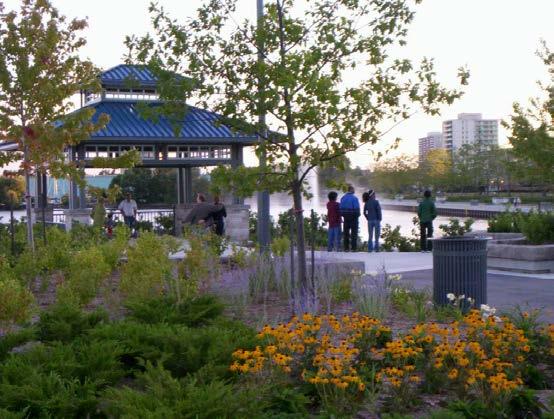
44 Precinct Vision: Heart of the Waterfront, Waterfront Village, Passive and Active Recreational Tourism Destination. The Port Whitby Community Precinct would build on its significant role as the heart of the waterfront with over 50 hectares of parks and community facilities, the Port Whitby Marina and Whitby Yacht Club, Station Gallery, the Abilities Centre, Iroquois Park Sports Centre and the Whitby GO station. The Port Whitby Community Precinct would become a vibrant and animated waterfront centre, with an existing transit node (GO Station), the area has the potential to expand into a fully accessible tourism node for both the Region and the Town. The precinct is proposed to provide commercial, cultural, and recreational amenities and improved access to Victoria Fields, open spaces, Iroquois Beach, and other areas of the waterfront. The concept design for the precinct includes a new urban park design for Victoria Fields, improvements to Iroquois Beach and other park expansions, an improved Waterfront Trail, secondary trails, improved street and pedestrian connections to parks and open spaces and connections across the GO / Highway 401 corridor. 1 2 A new urban park would provide a variety of activities for a wide range of users. There would be a focus on providing a variety of year-round activities to help draw visitors to the Whitby waterfront in all seasons. 33 Corporation of the Town of Whitby Waterfront Trail Improvements - Improvements would occur along the length of the existing Waterfront Trail, including trail widening on Gordon Street and formalized trails through Victoria Fields, and the provision of seating areas and other amenities. A new 6 metre multi-use trail is proposed along the western shore of the Whitby Harbour lands, between the Gordon Street Fields and the Whitby Yacht Club. This would provide better views of the water and harbour area. A multi-use trail would also be provided along the perimeter of the Brookfield property, south of the Port Whitby Marina. Streetscape / Connection Improvements - A portion of Gordon Street would be enhanced, as well as connections between Gordon Street and the Waterfront Trail, at the southern edge of the Gordon Street Fields and along the edge of the Whitby Yacht Club to Iroquois Beach. Portions of Watson Street and Front Street West would also be enhanced to create main street conditions. Redevelopment Opportunities - Sites would be redeveloped along either side of Watson Street, and along the north side of Front Street West. Park Improvements - Park improvements would be provided south of Victoria Street and east of Gordon Street. Existing sports fields at the Gordon Street Fields and Victoria Street Fields could be relocated. The new park could include a performance area. Iroquois Beach would be improved and new boardwalk trails would be provided to improve access through the existing PSW Protection Area. Recommended Views - A viewing area / platform would be located adjacent to the Port


45 Whitby Marina to take advantage of high visitor volumes in this area. This feature would provide a significant vantage point of the Port Whitby Marina and Harbour lands to the south, as well as seating areas and other amenities. Parking Improvements - An expanded surface parking area would be provided adjacent to Gordon Street and the Whitby Yacht Club, providing improved access to Iroquois Beach. 3 4 A variety of amenities and attractions could help to draw local residents to a new active waterfront area in Victoria Fields. Iroquois Beach would be improved to become a prominent waterfront destination. 5 Victoria Waterfront Park would provide an outdoor performance area of some sort. 6 7 The area surrounding the Port Whitby Marina would be enhanced to promote important views and vistas. The Brookfield Development site would provide opportunities for landscaping, recommended views and trails to enhance the heart of the waterfront. Brook McIlroy Inc., SENES Consultants Ltd., and Ipsos Reid 34
46 3.1 Wayfinding Markers Wayfinding markers, signifying the relevant location to nearby trails, landmarks, or other amenities, would be placed at key locations along the length of the Waterfront Trail. The markers are recommended to be three pronged, and would be comprised of cast steel poles with steel or wood panels. Wayfinding information would be depicted on each panel. Markers would incorporate both Town of Whitby and CLOCA logos m North 35 Corporation of the Town of Whitby


47 3.2 PSW Protection Area Boardwalks The PSW Protection Area, between Gordon Street, the Whitby Yacht Club and Iroquois Beach, would accommodate a network of boardwalk trails. These trails would support potential improvements to Iroquois Beach while ensuring the preservation of the PSW lands. The wooden boardwalk could be 3 metres wide to allow for a significant volume of users, including pedestrians and cyclists m North Brook McIlroy Inc., SENES Consultants Ltd., and Ipsos Reid 36


48 3.3 Iroquois Beach Secondary Trail Improvements A portion of the existing Secondary Trail, between Gordon Street at the Ontario Shores Centre for Mental Health Sciences and Iroquois Beach, would be widened to 4.0 metres. This would allow for a greater volume of users, including pedestrians and cyclists, and would help support potential improvements to Iroquois Beach. The trail would be comprised of a low impact permeable and accessible surface to support the area s natural character, and would be framed on either side by woodlands m North 37 Corporation of the Town of Whitby


49 3.4 Victoria Waterfront Park Providing for a multitude of active and passive uses and programmed and non-programmed functions, the park currently known as Victoria Fields would become a waterfront destination park within Whtiby. The urban park may be renamed as Victoria Waterfront Park to create greater prominance. A promenade (Waterfront Trail) would highlight the park s connection to the harbour and would afford pleasant views across the bay. A large open lawn area - bordering the promenade - would provide a flexible area to host large outdoor events. A central active-use area containing playgrounds, adventure play areas, a skating rink/splash pad, would support surrounding neighbourhoods but also be a be beacon for the Town to attract regional interest. Lighting would be provided to support evening and year-round use. A flat grassed area would allow for flexible active use and traditional park planting areas large shade trees in lawn provide a variety of intimately scaled spaces for passive enjoyment. Two parking lots have been located along the western boundary of the park, and the existing parking lot, along the eastern boundary, has been maintained. Parking areas can be permanently expanded without impacting major park elements, should the need arise. In addition, a variety of parking lots can be provided, including overflow parking for special events that doubles as green space when parking is not required m North Brook McIlroy Inc., SENES Consultants Ltd., and Ipsos Reid 38


50 39 Corporation of the Town of Whitby Victoria Waterfront Park


51 Brook McIlroy Inc., SENES Consultants Ltd., and Ipsos Reid 40

52 41 Corporation of the Town of Whitby Concept: Victoria Waterfront Park Improvements

53 Brook McIlroy Inc., SENES Consultants Ltd., and Ipsos Reid 42


54 3.5 Port Whitby Harbour Multi-Use Trail Extension The western edge of the Port Whitby Harbour, south of Victoria Fields and east of Gordon Street, would accommodate a Secondary Trail / southern extension of the Waterfront Trail. The trail would run along the water s edge, connecting the existing segment of the Waterfront Trail at Victoria Fields to the parking lot at the southern terminus of Gordon Street and Iroquois Beach. The trail is recommended to be 4.0 metres wide to allow for a significant volume of users, including pedestrians and cyclists. The trail would be comprised of a hardscaped surface to support the prominent and urban nature of the Port Whitby Harbour area. The trail would include a 3 metre wide resting areas, characterized by bumpouts along the length of the trail. Such resting areas would incorporate seating, and would be framed by street trees and other plantings. At it s southern-most point, the Secondary Trail would extend into the Provincially Significant Wetland. The area through which the trail is proposed has been historically used for the disposal of dredged material from Whitby harbour and some areas are experiencing natural succession. Should the Town choose to develop this Secondary Trail, the Town would need to work with CLOCA to determine the best location in order to ensure it minimizes any negative effects to wildlife and bird habitat. As part of determining the exact location and character of the Secondary Trail, the Town would determine if an Environmental Assessment or other permits will be required and would undertake the analysis necessary to support these approvals m North 43 Corporation of the Town of Whitby Note: Conceptual road cross-sections will require more in-depth review

55 3.6 Iroquois Beach Improvements A trail-head, expanded parking lot and washroom/change room facility would better announce the presence of this hidden but beautiful park which is often missed by the passerby. A system of boardwalks through the existing forested area and adjacent to the Provincially Significant Wetland would allow the public to see and interpret this important natural feature. Additionally, the introduction of buffer planting to the North and a picnic area bordering the park would provide a space for people to linger. These new features, along with a groomed beach, would enhance the inherent value of this small but significant slice of land. Washroom facilities would be remote to the beach to optimize utility connections, to provide ready access for the service, and to provide better oversight and visibility from adjacent streets. It is recommended that the shore wall adjacent to the surface parking lot, which serves the Yacht Club, be enhanced to permit public pedestrian access to the west pier m North Gordon Street Expand Parking Improved Existing Parking Trail Head + Park Entry Node Vehicle Dropoff Forested Area Interpretive Node Washroom + Change Facility Wetland Informal Picnic Area Beach Buffer Planting Shade Structure / Seating Area Brook McIlroy Inc., SENES Consultants Ltd., and Ipsos Reid 44

56 45 Corporation of the Town of Whitby Concept: Iroquois Beach Improvements

57 Brook McIlroy Inc., SENES Consultants Ltd., and Ipsos Reid 46

58 3.7 Marina Area Improvements The Port Whitby Marina area could be improved by incorporating a number of recommended enhancements. Such improvements include new commercial uses related to the marina and waterfront, as well as a marina services building, buffer plantings at various locations, the dedication of an open lawn area at the intersection of Brock Street South and Front Street West, and improved surface parking at the southern terminus of Charles Street. Other improvements would include a main street entry node at the intersection of Brock Street South and Front Street West, an improved main street treatment along Front Street West, emphasizing pedestrian accessibility, a seasonal Secondary Trail connection feeding from Victoria Park through the marina connecting to the existing Waterfront Trail network at Charles Street and Front Street. Access to the proposed Secondary Trail would be restricted during annual boat launch and haul out periods. The gates to the marina area would remain intact as boat security remains a high priority m North Buffer Planting Existing Land Uses Marina-Related Uses Watson Street W 47 Corporation of the Town of Whitby Secondary Trail is seasonal and closed during the winter, launch and haulout Natural Drainage Channel Outdoor Storage Potential Ground Floor Commercial for Marina Buffer Planting Marina-Related Uses Improved Existing Parking Improved Commercial Street Marina Boundary Improved as Main Street. Emphasized pedestrian accessibility. Open Lawn Area Relocate Exisitng Sea Cadets to within Marina Area Brock Street S Main Street Entry Node


59 3.8 Watson Street Improvements The length of Watson Street, between Victoria Fields and Brock Street South, would be transformed into a prominent main street for the Whitby Waterfront. There is a sidewalk on the north side of the street, and 2.5 metre Waterfront Trail on the south side of the street. This boulevard should be characterized by street trees and low-lying vegetation, as well as hardscaped areas with seating and bicycle racks. The portion of Watson Street, between Victoria Fields and Charles Street, the 2.5 metre Waterfront Trail may be widened to 4.0 metres in later years, if it is necessary to accomodate a greater number of users. This portion of the trail would be comprised of a hardscaped surface to support the urban character of Watson Street. It is recommended that the roadway be re-configured to accommodate on-street parallel parking on the south side of Watson Street. This would reduce reliance on surface parking lots m North Note: Conceptual road cross-sections will require more in-depth review, due to soil and drainage constrainsts, proposed facilities within the road aallowance may not be possible. Brook McIlroy Inc., SENES Consultants Ltd., and Ipsos Reid 48

60 3.9 Charles Street Improvements The length of Charles Street, between Watson and Front Streets, has a 2.5 metre wide segment of the Waterfront Trail on the west side of the street. The trail may be widened to 4.0 metres in later years, if it is necessary to accomodate a greater number of users A buffer planting area would be provided between the existing roadway and the trail, with additional buffer planting provided between the trail and existing uses to the west m North 49 Corporation of the Town of Whitby Note: Conceptual road cross-sections will require more in-depth review

61 3.10 Front Street West Improvements The length of Front Street West, between the existing Sea Cadets building and Brock Street South, would be transformed into a prominent main street for the Whitby Waterfront. The reconfiguration would include a sidewalk / boulevard on the north side of Front Street West. The boulevard would be characterized by street trees and low-lying vegetation, as well as hardscaped areas with seating and bicycle racks. A portion of this segment of Front Street West is recommended to include a 2.5 metre Secondary Trail to the south of the street. The trail would accommodate a significant volume of users, including pedestrians and cyclists. This portion of the trail would be comprised of a hardscaped surface to support the urban character of Front Street West. It is recommended that the roadway be re-configured to accommodate on-street parallel parking on the north side of Front Street. This would reduce reliance on surface parking lots m North Note: Conceptual road cross-sections will require more in-depth review Brook McIlroy Inc., SENES Consultants Ltd., and Ipsos Reid 50
62 Precinct 4: Pringle Creek Harbour Street Possible Extension Kiwanis Heydenshore Park 5 Driveway / Loading Parking Street-oriented Commerical Building Pumphouse Improvements Fence Improvement New or Renovated Event Centre Corporation of the Town of Whitby 4.1 P Shoreline Enhancements to Support Native Plants, Wading Birds and Turtles Refer to Pricinct Section Text Waterfront Trail (Improved) Secondary Trail Recommended Viewing Location Victoria Street Proposed Boulevard Multi-use Path (Cycling and Leisure Master Plan) Existing Parking * Please note that the concept plans are intended to provide guidance for the detailed design phase. Information appearing on the concept plans may be subject to change or further refinement based on future studies. P # 10 Proposed / Improve Parking Streetscape Improvements Cross-section Detailed Design Area Precinct Boundary New Destination Reconfigured Street Refer to Precinct Vision Image North


63 Precinct Vision: Residential Area, Employment Area, and Passive Recreational Destination. The Pringle Creek Precinct would become a local and regional destination among its surrounding neighbourhoods, large industrial sites and Provincially Significant Wetlands located at the mouth of Pringle Creek. The concept design focuses largely on providing greater access to Rotary Sunrise Lake Park through improvements to the Waterfront Trail, the creation of a secondary trail between Victoria and Water Streets, and improvement of the Heydenshore Pavilion for special events. The concept design proposes preserving and enhancing the old Pump House as an open air pavilion and cultural feature for other special activities. In addition to improved access to Kiwanis-Heydenshore Park, open spaces, and the waterfront, the concept includes a secondary multi-use trails, improved connections to parks and open spaces, recommended viewing locations, streetscape improvements, improved parking areas, park improvements and expansions, and enhancements to the composition of the shoreline at Kiwanis- Heydenshore Park. 1 2 The Waterfront Trail width would be expanded to promote active transportation. Views of Lake Ontario would be enhanced by the Pumphouse / cultural feature. 3 Streetscape improvements and new trail connections would provide new and enhanced opportunities for walking and bicycling. Waterfront Trail Improvements - Improvements would occur along the length of the existing Waterfront Trail, including trail widening and the provision of seating areas and other amenities. Streetscape / Connection Improvements - A future north-south trail connection would be provided, connecting Water Street to the south with South Blair Street adjacent to Victoria Street to the north. Water Street would be enhanced as a green and vibrant street with a 4 Existing surface parking lots would be enhanced to incorporate pedestrian walkways and tree plantings. new commercial building. New Destinations - The Pump House would be improved to create a new cultural feature, event centre. Park Improvements - The fence surrounding the water supply plant may be improved to soften the edge between the building and Kiwanis Heydenshore Park. A discussion of the Kiwanis Heydenshore Park expansion is provided in Precinct 5: (Former) Dupont and Gerdau Shoreline. Brook McIlroy Inc., SENES Consultants Ltd., and Ipsos Reid 52


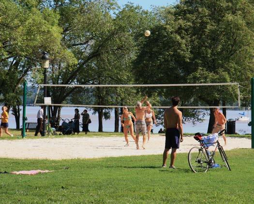
64 Parking Improvements - An expanded garden surface parking area would be provided adjacent to the intersection of Water Street and South Blair Street, providing improved access to Kiwanis Heydenshore Park. Shoreline Improvements - It is recommended that the Town explore the feasibility of changing the beach at Kiwanis-Heydenshore Park to sand, from pebble. Such an enhancement would improve the attractiveness and viability of the beach as a major waterfront destination. 5 6 Benches and tables could be used to encourage picnics and could help prolong the stay of visitors to the Whitby waterfront. 7 Fire pits and public barbecues could encourage cooking and help prolong the stay of visitors to the Whitby waterfront Corporation of the Town of Whitby Kiwanis Heydenshore Park will continue to function as Whitby s premiere waterfront beach destination. 9 Year-round washrooms could be provided in locations where park or waterfront features are utilized throughout the winter months. Bicycle locks could be provided along the length of the Waterfront Trail to help promote active transportation. 10 The transition between Kiwanis Heydenshore Park and the DuPont Lands could be signified through the use of low-lying vegetation.


65 4.1 Harbour Street / Spur Line Trail Extension The length of the Harbour Street / spur line corridor, between the CN Rail corridor / potential reconfiguration of Victoria Street East and Brock Street South, would accommodate a Secondary Trail extension. Such an extension would improve the connection between the Town of Whitby to the north and the Waterfront to the south. Consideration should be given to acquiring the CN spur line immediately east of Harbour Street between Water Street and Watson Street, in order to allow for the realignment of Harbour Street to the east, allowing the trail to move along the west side of a relocated Harbour Street. There is tremendous development potential in the vicinity for new industrial and office development on Harbour Street, which would be aided by its realignment. It is recommended that a study be undertaken to look at alternative design solutions in the vicinity of Water and Harbour Streets to provide needed street access to these industrial properties and improved traffic movements. This may include the closing of Watson Street to vehicular traffic east of Galt / Harbour Street. The need for this local link warrants review in that GO is proposing an underpass at South Blair Street. The trail is recommended to be set back 3.0 metres west of the realigned Harbour Street, providing adequate space for plantings. The trail is recommended to be 2.5 metres wide to allow for a significant volume of users, including pedestrians and cyclists. The trail would be comprised of a low impact hard surface given its location in the right-of-way. It is recommended that native grasses and shrubs be planted east of a reconfigured Harbour Street, to provide a natural buffer and habitat for small insect eating birds and butterflies. Note: Conceptual road cross-sections will require more in-depth review m North Brook McIlroy Inc., SENES Consultants Ltd., and Ipsos Reid 54

66 4.2 Water Street Improvements The portion of Water Street, adjacent to Kiwanis Heydenshore Park, would be transformed into a green and vibrant street along the Whitby Waterfront. The street would be lined with sidewalks on either side of the road. Boulevards would be characterized by street trees and landscaped areas. A planting area would be provided along the north side of Water Street. A multi storey commercial and office building is recommended north of Water Street. The second storey of this building could be set back, creating sufficient space for an outdoor restaurant or cafe patio. Parking, loading, and servicing functions would be provided behind the new building, and accessed from South Blair Street. 55 Corporation of the Town of Whitby Note: Conceptual road cross-sections will require more in-depth review


67 0 600 m North Brook McIlroy Inc., SENES Consultants Ltd., and Ipsos Reid 56

68 4.3 Kiwanis Heydenshore Park Improvements and Extension The concept plan expands Kiwanis Heydenshore Park considerably to the east, and promotes important enhancements to the existing and well used areas of the park. A large open lawn area occupies the northeast corner of the park expansion along with a new parking lot intended to serve both the field and expanded beach area. Additionally, beach volleyball and possibly other sports are located in this new active sports zone, along with a supporting washroom facility and shade structure. A trailhead node at the junction of South Blair Street and Water Street creates a sense of entry into the park and defines one end of a central promenade. At the south end of the promenade, another node acts as a waterfront anchor, tying the existing and new areas of the park together. The beach area is expanded and additional access points have been added, including stairs down to the beach to facilitate enhanced circulation. Boulevard / Streetscape Improvements Commercial/ Office Existing Playground Green Gym Special Events Centre Demonstration Gardens Existing Washrooms Proposed Parking 57 Corporation of the Town of Whitby Existing Playground Existing Splash Pad Existing Shade Structure Maintained Beach


69 As this park is well used in the summer, informal picnic areas above the beach have been suggested to allow more residents to enjoy the warm summer sun and views to Lake Ontario, and a green gym was constructed in June of 2012 adjacent to the existing playground. Existing areas of the park are generally unchanged as they are currently well used. The redevelopment of the pavilion is an important component of the concept as this facility must become more appealing and be better utilized to act as a multi-season draw to the site. In addition to redeveloping the pavilion building, the associated outdoor spaces would also be upgraded by creating an enhanced entry feature, outdoor terrace space, and provide beautiful views from the front event space to the lake. To increase parking, two surface lots are suggested at the eastern termination of Water Street at South Blair Street m North Year Round Washrooms Buffer Planting Shade Structure Informal Picnic Area Open Lawn Area / Free Play Area Existing Planting Volleyball Courts Forested Area and Future Expansion Area Brook McIlroy Inc., SENES Consultants Ltd., and Ipsos Reid 58
70 4.4 Wayfinding Markers Wayfinding markers, signifying the relevant location to nearby trails, landmarks, or other amenities, would be placed at key locations along the length of the Waterfront Trail. The markers are recommended to be three pronged, and would be comprised of cast steel poles with steel or wood panels. Wayfinding information would be depicted on each panel. Markers could incorporate both Town of Whitby and CLOCA logos m North 59 Corporation of the Town of Whitby


71 4.5 Pump House The Whitby Pump House is a significant cultural heritage feature. The Pump House, constructed in 1903, should be preserved and enhanced. It would be improved to create a new cultural feature and an open air pavilion m North Pumphouse building view from the north west side Pumphouse building interior Pumphouse building view from east side Brook McIlroy Inc., SENES Consultants Ltd., and Ipsos Reid 60
72 Precinct 5: (Former) Dupont and Gerdau Shoreline Future Victoria Street Alignment (Transportation Master Plan) Future GO Transit Maintenance Facility (GO Transit EA) Kiwanis Heydenshore Park Expansion 2 Nesting Boxes 61 Corporation of the Town of Whitby 5.1 P Refer to Precinct Section Text Waterfront Trail (Improved) Secondary Trail Improved Connection / Streetscape Recommended Viewing Location Victoria Street Proposed Boulevard Multi-use Path (Cycling and Leisure Trails Plan) Existing Viewing Area Connection Improvements Future Connection / Alignment Detailed Design Area Educational Opportunities Proposed / Improve Parking Precinct Boundary 3 4 Viewing Areas 1 Improve Visual Quality of Berms # Refer to Precinct Vision Images * Please note that the concept plans are intended to provide guidance for the detailed design phase. Information appearing on the concept plans may be subject to change or further refinement based on future studies. North
 Dupont and Gerdau Shoreline Precinct would focus its role away from the surrounding industrial lands and extend the beauty of its remote, natural and peaceful shoreline.")


73 Precinct Vision: Employment Area and Natural Waterfront Corridor. The (Former) Dupont and Gerdau Shoreline Precinct would focus its role away from the surrounding industrial lands and extend the beauty of its remote, natural and peaceful shoreline. The lake front lands are a local and largely naturalized destination offering improved access to local parks and will provide additional open spaces through the eastward expansion of Kiwanis-Heydenshore Park, as well as improved access to the waterfront. The concept for the precinct includes an improved Waterfront Trail, recommended viewing locations, improved parking areas, education opportunities, and park improvements and expansions. The precinct contains Gordon Richard s Park, Ronald C. Deeth Park, and Waterfront Trail Open Space. The open spaces adjacent to the Waterfront Trail are naturalized, with a gazebo and a lookout area along the route. 1 3 The area could be largely naturalized, including native plantings. Existing berms could be enhanced to improve views. 2 Parking lots could be provided on the west and east side of the precinct, adjacent to the Waterfront Trail. (5.4) Wayfinding signage would be provided along the length of the Waterfront Trail to inform uses on distance travelled and key destinations. Brook McIlroy Inc., SENES Consultants Ltd., and Ipsos Reid 62

74 4 Significant views of Lake Ontario would be preserved and enhanced with lookout points / pavilions. 63 Corporation of the Town of Whitby Waterfront Trail Improvements - Improvements would occur along the length of the existing Waterfront Trail, including trail widening up to 6.0 metres and the provision of seating areas and wayfinding. (5.3) Streetscape / Connection Improvements - A portion of Victoria Street would be realigned, and the existing jog would be removed. Education Opportunities - Education opportunities would be provided at strategic locations along the Waterfront Trail. Park Improvements - Kiwanis Heydenshore Park would be expanded east of South Blair Street, creating adequate space for passive activites, informal play, a picnic area and an open space. The visual quality of berms between the Waterfront Trail and the Gerdau buildings could also be improved with planting and trees to soften the edge between built and natural features. Recommended Views - Viewing areas / platforms could be located along the Waterfront Trail between South Blair Street and Thickson Road South. These features would provide significant vantage points of the berms and nature landscapes to the north and Lake Ontario to the south, and would include seating and other amenities. Parking Improvements - New surface parking areas would be provided adjacent to South Blair Street and Thickson Road South, providing improved access to an expanded Kiwanis Heydenshore Park to the west and Gordon Richards and Ronald Deeth Parks to the south.

75 5.1 Wayfinding Markers Wayfinding markers, signifying the relevant location to nearby trails, landmarks, or other amenities, would be placed at key locations along the length of the Waterfront Trail. The markers are recommended to be three pronged, and would be comprised of cast steel poles with steel or wood panels. Wayfinding information would be depicted on each panel. Markers could incorporate both Town of Whitby and CLOCA logos. North Brook McIlroy Inc., SENES Consultants Ltd., and Ipsos Reid 64
 Dupont and Gerdau Shoreline")
76 65 Corporation of the Town of Whitby Concept: (Former) Dupont and Gerdau Shoreline Improvements

77 Brook McIlroy Inc., SENES Consultants Ltd., and Ipsos Reid 66
78 Precinct 6: Corbett Creek Marsh Future Connection as Identified in the Transportation Master Plan 2 Bridge Improvements 1 Thickson Woods 67 Corporation of the Town of Whitby 6.1 Refer to Precinct Section Text Waterfront Trail (Improved) Secondary Trail Improved Connection / Streetscape Recommended Viewing Location Victoria Street Proposed Boulevard Multi-use Path (Cycling and Leisure Trails Plan) Pedestrian and Cyclist Gateway Marker Existing Bird Watching Naturalized Area to 3 Minimize Access to Marsh Relocated Memorial Garden Educational Opportunities on Corbett Creek Marsh, Bird Watching New Destination Future Connection / Alignment Detailed Design Area Educational Opportunities Proposed / Improve Parking Precinct Boundary Cross-section Refer to Precinct Vision Images * Please note that the concept plans are intended to provide guidance for the detailed design phase. Information appearing on the concept plans may be subject to change or further refinement based on future studies. P # Corbett Creek Marsh Intrepid Park North


79 Precinct Vision: Employment Area, Significant Natural and Cultural Heritage Area, and Passive Recreational Destination. The Corbett Creek Marsh Precinct is the second largest environmentally sensitive area on the waterfront and includes Intrepid Park and approximately 40 hectares of open space. The Concept Plan builds on the importance of the parkland as a defining entry point to the Town and Whitby s waterfront. Nature viewing to Corbett Creek Marsh and the introduction of Memorial gardens dedicated to the historic significance of Camp X offers improved access to Intrepid Park as well as the waterfront. The concept for the precinct includes an improved Waterfront Trail, secondary multi-use trails, pedestrian and cyclist gateway markers at key locations, bridge improvements, education opportunities, park improvements, recommended viewing locations, and a new parking area. The precinct also includes sensitive lands including the Thickson Woods Old Growth Forest and Corbett Creek Mouth Marsh. 1 2 Functional bridge improvements are required along the Waterfront Trail to improve the safety of visitors. 3 Intrepid Park would remain largely naturalized, and access to Corbett Creek Marsh would remain restricted to protect the natural environment. The Waterfront Trail would be enhanced, particularly surroundi ng the Waste Water Facility. 4 A viewing platform / pavilion would promote views to Lake Ontario. The feature could also include educational opportunities. Brook McIlroy Inc., SENES Consultants Ltd., and Ipsos Reid 68


80 5 6 The western portion of Intrepid Park would be naturalized to ensure an appropriate buffer between the park and Corbett Creek Marsh. The Camp X Memorial. 7 8 Opportunities for public art would be considered throughout Intrepid Park. Informative signage would be provided to educate visitors on local bird species, area history, and to promote bird watching Corporation of the Town of Whitby Seasonal bird watching would be promoted.
81 Waterfront Trail Improvements - Improvements would occur along the length of the existing Waterfront Trail, including trail widening up to 4.0 metres and the provision of seating areas, wayfinding and other amenities. Streetscape / Connection Improvements - Connection improvements would occur along the length of existing pedestrian bridges, located on either side of the Region of Durham Waste Water Treatment Facility. Future north-south pedestrian connections would be established between the Waterfront Trail and Wentworth Street. Education Opportunities - Education opportunities would be provided at strategic locations within Intrepid Park. Park Improvements - Intrepid Park may have a memorial garden to compliment the Camp X Memorial. Limited access westward through Intrepid Park would be encouraged, and a natural buffer would be provided to minimize access to Corbett Creek Marsh. Gateway Improvements - Pedestrian and cyclist gateway markers would be located along the Waterfront Trail, adjacent to Boundary Road. Recommended Views - A viewing area / platform would be located along the water s edge in Intrepid Park. This feature would provide significant vantage points of Corbett Creek Marsh to the west and Lake Ontario to the south, and would include seating areas and other amenities. Parking Improvements - A new surface parking area could be provided adjacent to Boundary Road, providing improved access to Camp X and Intrepid Park. Brook McIlroy Inc., SENES Consultants Ltd., and Ipsos Reid 70


82 6.1 Waterfront Trail Improvements The length of the Waterfront Trail, running between Thickson Road South and Boundary Road, would be widened to 4.0 metres. This would allow for a significant volume of users, including pedestrians and cyclists. The trail would be comprised of a low impact accessible and permeable surface to support the natural character of the area. Opportunities to widen the corridor sections of the Waterfront Trail, surrounding the treatment facility would be explored m North 71 Corporation of the Town of Whitby


83 6.2 Trail Bridge Improvements The multi-use bridge connection, on the east side of the Waste Water Treatment Facility, would be improved to address existing issues pertaining to bridge footings. The bridge is recommended to be comprised of wood, with 1.2 metre high railings and an interpretive panel, informing site visitors of the significance of the surrounding Thickson Woods and Corbett Creek Marsh, as well as the animals which inhabit it. The bridge should be 4.0 metres wide m North Brook McIlroy Inc., SENES Consultants Ltd., and Ipsos Reid 72


84 Naturalized Area Buffer 6.3 Intrepid Park Improvements The concept plan incorporates a new Memorial Garden, which takes the form of the footprints from the former Camp X buildings, which were used to train Allied Spies during the Second World War. The Memorial Garden is also situated to provide significant views of the Lake Ontario shoreline, and acts as a strong visual terminus to vehicles traveling south along Boundary Road. The concept incorporates a new parking area, which would support increased visitor volumes as well as a large open lawn, a park entry node, planting areas, educational and bird watching opportunities at Corbett Creek Marsh, naturalized areas, Secondary Trails, and a connection to the Waterfront Trail. Access to the beach and adjacent wetland area is discouraged as these sensitive natural features would not tolerate increased use. Such access is to be limited to existing informal trails m North Open Lawn + Picnic Area Open Lawn Wetland Park Node Entry 73 Corporation of the Town of Whitby Naturalized Area Beach Area Memorial Gardens

85 6.4 Intrepid Park Gateway and Wayfinding Marker A gateway marker, signifying the entrance to the Whitby Waterfront and Corbett Creek Marsh from the City of Oshawa to the east, would be placed at the intersection of Boundary Road South with the Waterfront Trail. The marker is recommended to be three sided, and comprised of either steel or wood panels. The panels would include locationary signage as well as a map indicating the location of trail users relevant to the remainder of the Whitby Waterfront. Markers could incorporate both Town of Whitby and CLOCA logos m North Brook McIlroy Inc., SENES Consultants Ltd., and Ipsos Reid 74
86 75 Corporation of the Town of Whitby Concept: Intrepid Park Improvements
87 Brook McIlroy Inc., SENES Consultants Ltd., and Ipsos Reid 76
88 Phase Three Implementation 77 Corporation of the Town of Whitby The implementation strategy section lays out the necessary considerations for the overall scope of work to be completed, the recommended construction schedule and timing implications as well as the overall planning of the budgetary requirements. The strategy incorporates the Consultant s cost estimates for redevelopment for the entire Whitby Waterfront. The Parks Development Division, within the Town of Whtiby s Community and Marketing Services Deaptment may head most of the projects, however the Planning Department or the Public Works Department may be responsible for some developments. The Central Lake Ontario Conservation Authority, Durham Region, or the Government of Ontario are other parties which may implement enhancements as they are contained on lands they control. The implementation strategy is intended as a guide to direct the successful implementation of the Whitby Waterfront Parks and Open Space Master Plan over the next five, ten and twenty years. The implementation strategy includes: Phasing and Timelines - Establishes a series of principles to guide the implementation process, with detailed spreadsheets phasing and timeline considerations. Order of Magnitude Costing - Identifies the cost associated with specific waterfront park and open space improvements, organized by precinct. Implementation Considerations - Identifies recommendations pertaining to acquisitions and easements for future park land expansion; stakeholder roles; marketing and commercial opportunities; parks and open space maintenance and management; by-laws; wildlife management; approvals and coordination; and potential future studies. 7.1 Principles, Phasing and Timelines Implementation Principles - Implementation of the Waterfront Parks and Open Spaces Master Plan is dependent on the following principles: The order of development for parks and open spaces should proceed in order of greatest community need. Scheduling of park redevelopment should take into consideration waterfront use, legal regulations, availability of material and weather conditions. Development is dependent on the availability of funding from the Town and funding partners. Projects that are costshared or fully funded by groups would be considered if they respect the Waterfront Parks and Open Spaces Master Plan and the appropriate infrastructure is in place. Availability of specific types of funding may mean that certain aspects of the master plan would advance ahead of their anticipated priority. Development of the proposed park buildings with complimentary revenue generating facilities (i.e. Kiwanis Heydenshore Park Special Events Centre, Marina-Related Commercial Uses, and Water Street Commercial Uses) would assist in recovery of capital and maintenance costs and assist in the promotion, usage and marketability of the waterfront. The implementation of such facilities would be based upon a business plan and feasibility study. Phasing and Timelines - The Waterfront Parks and Open Spaces Master Plan would be implemented in phases over a period of twenty years. The phasing of such improvements will


89 occur in a manner which mitigates the impacts on residents and area visitors during the construction process. Phase One priorities includes the redevelopment of the Pumphouse and Victoria Fields at the later end of Phase One. The Pumphouse is a significant heritage feature that would be redeveloped in Upon the redvelopment of Victoria Fields, it is recommended the name of the park be changed to Victoria Waterfront Park to celebrate the transformation into a destination urban park. The estimated cost of $7,761,000, would include enhancements to the park to create a multitude of activities and uses. Kiwanis-Heydenshore Park is heavily used in the summer months and the redevelopment of Victoria Waterfront Park would address the growing demand and would provide increased options and opportunities for use. The expansion of Kiwanis-Heydenshore Park would constitute the first major park improvement in Phase Two. The redevelopment of Iroquois Beach and gateway and wayfinding markers would be implemented in Phase Three to facilitate improved access and visibility to the waterfront. Improvements to Intrepid Park would occur following the completion of other significant park and open space improvements in Phase Four, as its location is more remote within the Future work should ensure that the implementation process reflects the desired outcomes of contributing stakeholders. context of the Whitby waterfront. Improvements to the Marina Area would also occur in Phase Four, due to a variety of factors including the anticipated redevelopment of properties in the short to mid-term. Some of the planned improvements along Whitby s waterfront are contingent on further future studies and detailed designs / master plans, which may impact the phasing process. Park designs, on street parking, and cross sections shown or mentioned within the Waterfront Parks and Open Space Master Plan are conceptual in nature and that furthur review, analysis, and/or study by the Community and Marketing Services, Public Works, CLOCA, or the road authority having jurisdiction over the land will be required prior to any implementation. That comformity to the Town s Offical Plan, Parks standards, Transportation Master Plan, Engineering Standard would form part of the review process along with maintenance, operational, and asset management (lifecycle) implications be prepared for Council s consideration. 7.2 Implementation Considerations Implementation of the Town of Whitby s waterfront would largely be the responsibility of the Parks Development Division, however due to the multi-faceted characteristics of the plan, other departments such as Public Works, Planning, Corporate Services would Waterfront Trail Improvements and Secondary Trail Connections should be prioritized as shortterm development strategies. Brook McIlroy Inc., SENES Consultants Ltd., and Ipsos Reid 78


90 have direct influence on improvements to the waterfront Acquisitions and Easements for Future Park Land Expansion Criteria for Park Land Expansion - The need for acquisitions and easements for future park land expansion has not been identified in Phase Two, however should this situation arise in the future the following criteria are intended to provide direction to Town Staff and Town Council. To improve continuous public shoreline access; To expand recreational activities; To provide needed support facilities; To improve views to Lake Ontario and the Port Whitby Marina; To protect sensitive and/or natural features; To expand natural features and systems; To protect and explore cultural heritage elements; and To provide important east/west and north/ south connections. Methods of Park and Open Space Expansion - The Town of Whitby has many potential methods of expanding the land area of waterfront parks and open spaces. Some of these methods include outright conveyance, ownership, property easements, use or stewardship agreements, or public-private partnerships. Whenever development occurs along the waterfront, the Town should take steps to secure public park space adjacent to the water through redevelopment applications Stakeholder Roles Throughout the development of the Waterfront Parks and Open Spaces Master Plan, internal and external stakeholders have played an important role in shaping the guiding principles and the plan s key areas of concentration. Future work based on the recommendations of all contributing stakeholders should ensure that the implementation process reflects the desired outcomes Marketing and Commercial Opportunities When the Town of Whitby considers the marketing and commercial opportunities available to them, such as sponsorship or the provision of commercial spaces within park and open space areas, they must be assured that these endeavors do not undermine or interfere with the primary park programming use assigned for each park and open space area. The Town can and should pursue potential sponsorship partnerships to help achieve the designated park themes and visions identified in the Waterfront Parks and Open Spaces Master Plan for each park and open space area. Examples of marketing and commercial opportunities include, but are not limited to the following: 79 Corporation of the Town of Whitby Wildlife management may be required within waterfront parks and open spaces. Image by Aris Patelos. The pumphouse should be re-purposed to provide space for a new cultural feature along the Lake Ontario shoreline.

91 All wayfinding signage throughout the Precincts could be sponsored by a private organization to aid in funding the project; and The performance area in Victoria Fields may be sponsored through naming rights Revenue Generating Opportunities The Town of Whitby is encouraged to explore possible revenue generating opportunities within the plan, and to prioritize the phasing of such opportunities in order to reduce financial expenditures associated with planned improvements throughout the waterfront. Possible revenue generating opportunities include leasing agreements and event sponsoring. Leasing Agreements - The Town may have an organization enter into a leasing agreement, whereby a portion of the Town s facilities may be leased. The revenue generated would go to the general operation and renewal of the facility and park. Examples of leasing agreement opportunities include: New commercial facilities within the Marina Area; New commercial facilities adjacent to Kiwanis-Heydenshore Park. Event Sponsoring - Potential arrangements could be made, whereby the contributions and proceeds of such events can be contributed to the capital budget. Examples of such event sponsoring opportunities include: Festivals in Victoria Park, Banquets, guest lectures, performances, academic events, conferences and weddings at the Special Events Centre in Kiwanis-Heydenshore Park; and Art exhibits, recreational events and cultural events at the Pumphouse Alternative Funding Sources Through the implementation of the Waterfront Parks and Open Space Master Plan, the Town of Whitby is encouraged to explore possible alternative funding sources to reduce financial expenditures associated with planned improvements throughout the waterfront, including improvements to Intrepid Park, which is a Federally significant cultural heritage event site. Possible alternative funding sources include: Government - The Town of Whitby should explore alternative funding opportunities with upper levels of government. Depending on the location and scope of the improvement, this may include partnerships with either the Federal Government, the Provincial Government, or the Regional Government. In the case of Intrepid Park, for instance, the Town may explore partnership opportunities with the Federal Government in order to finance improvements to the Camp X Memorial site. The Town should explore alternative funding sources, including partnerships with the Federal Government, to implement improvements to Intrepid Park including the relocation of the Camp X Memorial. Brook McIlroy Inc., SENES Consultants Ltd., and Ipsos Reid 80


92 Private Sector - The Town of Whitby should explore partnership opportunities with the private sector, including prominent local and regional corporations. Such partnerships could result in funding in exchange for branding and marketing opportunities. Examples of potential private sector investments include: The events area and performance area within Victoria Park; Wayfinding signage throughout the waterfront; Public viewing areas throughout the waterfront; and Public art installations throughout the waterfront. Private sector investment opportunities also exist with respect to the Adopt a Park and Adopt a Trail programs, which are already established within the Town of Whitby Parks and Open Space Maintenance and Management Parks and Open Space Management Strategy - Whitby s waterfront parks and open spaces, represent a significant Town-wide resource. Management resources may need to be devoted to working with community groups, businesses, schools, and other stakeholders to develop activities, amenities and programs that meet community needs. Waterfront parks and open spaces should be managed to ensure such spaces are vibrant, attractive places that help build communities and assist the Town of Whitby in meeting its goal of being a healthy and livable community. As such, there should be a management structure for all parks south of Victoria Street that will ensure the cleanliness and safety of waterfront park and open space elements. Parks and Open Space Maintenance and Operations - The implementation of the Waterfront Parks and Open Space Master Plan can significantly impact capital budget, operations, and maintenance. Prior to development, Town of Whitby Staff from Community and Marketing Services, Corporate Services and Public Works must collaborate throughout the detail design process to ensure proper and efficient maintenance of the proposed facilities and elements are taken into consideration in the design process. The expected level of service along with the associated operations, meintenance and supervisory costs are to be taken into consideration as part of the overall facility development. comment specifically with respect, ongoing operating and maintenance costs. The Town of Whitby currently allocates a standard cost per acre for parks, open space and trail maintenance. The Waterfront Parks and Open Spaces strategy recognizes that parks, open spaces and trails along the waterfront may require a higher per acre 81 Corporation of the Town of Whitby Programming elements, including playgrounds, will require ongoing maintenance / operational expenditures. The Waterfront Trail will be formalized and widened in some areas to accommodate increased user volumes.

93 maintenance cost than the Town s other nonwaterfront parks. This higher cost is associated with achieving a higher order waterfront parks and open space system which includes high quality, durable park furnishings; a greater density of landscaping and planting, as well as the provision of seasonal plantings; maintenance for increased activities relative to other parks and open spaces; higher costs for winter maintenance to allow for year-round use of the entire Waterfront Trail and portions of some Secondary Trails; and the introduction of a system-wide integrated education and public art program which is more prominent than those existing within other Town parks and open spaces. The following provisions must be considered as the Town develops a comprehensive maintenance and operations strategy for the waterfront. Grass Cutting - Streets; the Waterfront Trail; Secondary Trails; the Lake Ontario shoreline; Victoria Park; Iroquois Beach; Rotary Sunrise Lake Park; Kiwanis-Heydenshore Park; Marina lands; and Intrepid Park. Snow Clearing - Streets; the Waterfront Trail; select Secondary Trails; the Special Events Centre; year-round washroom facilities; and all surface parking areas. Planting Bed Maintenance - Kiwanis- Heydenshore Park (demonstration gardens); and Intrepid Park (memorial gardens). Arboriculture Services - Waterfront Trail where double row of trees may be provided (Jeffrey Street, Gordon Street, Water Street, and reconfigured Harbour Street); where streetscape improvements are provided (Watson Street, Front Street, and Charles Street); and where new trees are planted adjacent to Secondary Trails (Victoria Park, Iroquois Beach, Marina lands, Kiwanis- Heydenshore Park, and Intrepid Park). Garbage / Recycling and Litter Pick-Up - The Waterfront Trail; Secondary Trails; Halls Road; Victoria Street; Whitby Shores Greenway; Water Street; Iroquois Beach; Victoria Park; Marina Lands; Kiwanis-Heydenshore Park; and Intrepid Park. Parking Area Maintenance - Halls Road (bumpout on-street parking); Victoria Street surface parking lot; Iroquois Beach surface parking lot and lay-by parking area; Victoria Park surface parking lots; Kiwanis- Heydenshore Park surface parking lots; Thickson Road surface parking lot; and Intrepid Park surface parking lot. Seasonal Implications and Repairs - Due to heavy use, year round use and limited snow cover, among other factors, a regular inspection schedule should be developed based on the asset type and this should include winter inspections. The Town of Whitby, Pubic Works Department Detailed park concepts, including those depicting improvements to Victoria Park, would need to undergo a detailed design process prior to construction. The results of the detailed design process may impact the phasing and timelines associated with each park improvement. Brook McIlroy Inc., SENES Consultants Ltd., and Ipsos Reid 82


94 will be undertaking a Town wide parks and open space maintenance requirement study in the near future. Recommended facilities within the Waterfront Parks and Open Space Master Plan would be incorporated into the maintenance requirment study and further consultation with the Community and Marketing Services staff occur as part of this study. Public Works expects that risks and opportunities for maintenance facilities would be further reviewed in detail as part of this study and will ultimately identify the most suitable type, function, location, size, and quality of long term maintenance facilities required throughout the Town and specifically along the waterfront By-Laws By-Laws are used to provide guidance towards appropriate activities for and within the waterfront parks and open space system. It is important that these by-laws are clearly displayed in a legible and easily comprehended manner. Steps would be taken by the Town to ensure that park by-law displays are integrated into proposed signage to eliminate unnecessary clutter Wildlife Management Wildlife within the parks and open space system is typically managed by Environment Canada and the Canadian Wildlife Service. It is unlawful to kill, sell, hunt, and disturb nests and immature animals unless permitted by Environment Canada. Although many forms of wildlife that find their way into the parks and open space system are not destructive, there are animals that do affect the environment in a negative way. Geese, deer, seagulls, raccoons and skunks, to name a few, do affect the parks and open space environment to an extent that wildlife management may become necessary. Any of the following criteria can result in the requirement to manage wildlife within waterfront parks and open spaces. Public safety is compromised; Public health is compromised; Eco-system becomes unbalanced; Park or open space maintenance is impeded; Access to the park or open space is impeded; and Fisheries require restocking. Persons living within and visiting the Whitby Waterfront should have respect for local and migratory wildlife. Fishing in Cranberry Marsh is not permitted, although permitted in other areas of Lynde Shores Creek marsh; Lynde Shores Conservation Area is an important place for many different wildlife species. This area is also an important stopover point for thousands of migratory waterfowl and shorebirds. Cranberry Marsh 83 Corporation of the Town of Whitby The area surrounding the Marina Building should be enhanced with marina-related commercial uses, trails, and viewing areas. The cost estimates provided for Waterfront Trail Improvements and Nodes incorporate landscaping treatments and furnishings.

95 is an important area where the public can take part in viewing raptors that fly over every fall; Unique plants and animals within Lynde Shores area and a permit would need to be applied for if venturing beyond the trail system and designated areas Approvals and Coordination The following section provides an overview of the necessary approvals and coordination that may be required to implement the Waterfront Parks and Open Space Master Plan. Design and development projects that effect change to the shoreline, river banks and adjacent sensitive lands may require special permits from CLOCA for specific projects and may also be subject to a formal Environmental Assessment. In addition, the normal municipal approvals process must be followed. In order to coordinate the various approvals, it is important that all stakeholders, including Community and Marketing Services, CLOCA, and the Ministry of the Environment are engaged early in the process. Conservation Authorities - CLOCA regulates development in environmentally sensitive areas throughout the waterfront. Redesign or improvement to existing infrastructure, as well as development and implementation of new infrastructure, requires approval from the appropriate public agency, including CLOCA, the Ministry of Natural Resources, the Ministry of the Environment, and the Department of Fisheries and Oceans. Shoreline modification, regarding placing of fill and construction of buildings in sensitive areas requires special permission from CLOCA. The authority reviews proposals for potential impacts on control of flooding, erosion, dynamic beaches, pollution and land conservation. If a project will potentially alter, disrupt or destroy a fish habitat, the federal Department of Fisheries and Oceans must also provide its approval. However, the Conservation Authorities have an arrangement with the Department of Fisheries and Oceans whereby applications are processed by the Conservation Authority on behalf of the department to: Advise on ways to avoid or mitigate impacts on fish habitats; or Specify a compensation package in respect of damage to fish habitats. Environmental Assessments - A Municipal Class Environmental Assessment typically covers road, water and wastewater projects that recur, are similar in nature, have predictable environmental effects, and are responsive to mitigating measures. There may be some improvements within the Waterfront Parks and Open Spaces Master Plan, which require an Environmental Assessment, such as Waterfront improvements, including the above illustrated shade structure, will require ongoing maintenance and management. Brook McIlroy Inc., SENES Consultants Ltd., and Ipsos Reid 84


96 boardwalk improvements and the restoration of Willis Creek within the Marina Lands in Precinct Three. The Town of Whitby would need to follow the Environmental Assessment process to obtain approval from the Ministry of the Environment. Undertaken by Other Parties Lynde Shores Conservation Area Master Plan; and Ontario Shores Centre for Mental Health Sciences Master Plan. Municipal Approvals - Municipal approvals may be required for some improvements to the Whitby Waterfront, including streetscape improvements to Watson Street, Front Street, Water Street, and Charles Street Potential Future Studies Undertaken by the Town of Whitby Comprehensive Waterfront Parks Signage and Wayfinding Strategy; Parks Master Plan for Iroquois Beach Improvements and Expansion; Parks Master Plan for Victoria Park Improvements; Business Plan for Marina Area Improvements; Business Plan and Parks Master Plan for Kiwanis Heydenshore Park Improvements and Expansion; Parks Master Plan for Intrepid Park Improvements; Detailed Design for Pumphouse; and Detailed Design for Special Events Centre; 85 Corporation of the Town of Whitby Pumphouse building interior Viewing points / pavilions may incorporate gazebos with areas to sit and pause.

97 8.0 Detailed Order of Magnitude Costing The following tables are the order of magnitude and costing. The estimates are for all components and elements contained in the Waterfront Parks and Open Space Master Plan. The estimated costs contained within this plan are based on concept plans and all prices are subject to revision based on final landscape plans, selection of materials, etc. The costs indicated are all exclusive of HST, contingency, and Professional Fees. The estimated costs do not include permit fees or coordination cost for required permits. The cost estimates also do not take into consideration: Demolition/removals Utility relocates Stormwater system upgrades/relocates Existing tree protection measures Planting along shoreline Protected Shoreline The costs provided in the plan are not to be taken as actual estimates and further detailed reports would need to be conducted. The costs are an approximation and are to be taken for order of magnitude purposes only. Iroquois Beach could be improved to become a prominent waterfront destination. Lookout points / pavilions could be provided to promote and enhance views of Lake Ontario and Lynde Marsh. Brook McIlroy Inc., SENES Consultants Ltd., and Ipsos Reid 86

98 Precinct 1: Cranberry and Lynde Marshes Feasibility and Alignment of Secondary Trail subject to CLOCA Master Plan Lynde Shores Conservation Area Cranberry Marsh Lynde Creek Marsh 87 Corporation of the Town of Whitby North 1.1 Refer to Precinct Section Text Waterfront Trail (Improved) Secondary Trail Improved Boardwalk Recommended Viewing Location Victoria Street Future Connection to North Conservation Area Entrance Proposed Boulevard Multi-use Path (Cycling and Leisure Trails Plan) Proposed On-Road Bikeway (Cycling and Leisure Trails Plan) Lynde Shores Conservation Area Educational Opportunities New Bird Watching Platform Pedestrian & Cyclist Gateway Existing Parking Proposed / Improve Parking Precinct Boundary Lookout point Cross-section * Please note that the concept plans are intended to provide guidance for the detailed design phase. Information appearing on the concept plans may be subject to change or further refinement based on future studies. P P
99 8.0 Detailed Order of Magnitude Costing Precinct 1:Cranberry and Lynde Marshes Preliminary Costing Item Description of Work Phase 1 (0-5 Years) Phase 2 (6-10 Years) Phase 3 (11-15 Years) Phase 4 (16-20 Years) North Conservation Area Entrance 1.8 Future Connection to North Conservation Area Entrance Note: Responsibilty - Community and Marketing Services (CMS) Department a) Secondary trail (Along Jeffery St. between Victoria St. S & LSCA) 3m $98,000 Halls Road South Wildlife Learning Area 1.3 Halls Road South Waterfront Trail Improvements Note: Responsibilty - CMS Department b) Educational node (pad treatment + sign + plantings) 1.4 Halls Road South Victoria Street Waterfront Trail Realignment Note: Responsibilty - CMS Department a) Educational node (pad treatment + sign + plantings) Bicycle Parking and Additional Greening 1.3 Halls Road South Waterfront Trail Improvements Note: Responsibility - CMS Department d) Bicycle racks $1,000 $10,000 $10,000 Brook McIlroy Inc., SENES Consultants Ltd., and Ipsos Reid 88
100 Precinct 1:Cranberry and Lynde Marshes continued Item Description of Work Phase 1 (0-5 Years) Gateway and Wayfinding Markers 1.1 Lynde Shores Conservation Area (LSCA) Gateway and Wayfinding Marker Note: Subject to Wayfinding Study, Responsibility - CMS in partnership with CLOCA Gateway Markers: a) South entrance Lake Ridge Rd b) Eastern edge of LSCA Lynde Shores Conservation 1.5 Area Gateway Marker Note: Responsibility - CMS in partnership with CLOCA Gateway Marker: a) Gateway Marker entrance of LSCA Subtotal (excluding HST) Total (excluding HST) Phase 2 (6-10 Years) Phase 3 (11-15 Years) $50,000 $25,000 Phase 4 (16-20 Years) N/A $1,000 $95,000 $98,000 $194, Corporation of the Town of Whitby
101 Brook McIlroy Inc., SENES Consultants Ltd., and Ipsos Reid 90

102 Precinct 2: Lynde Shores Potential Northern Gateway to Conservation Area subject to CLOCA Master Plan Possible Future Connection as Identified in the Transportation Master Plan Connection Improvements Portage Park Improved Signage Improved Signage Planned New Community Under Construction 91 Corporation of the Town of Whitby 2.1 Feasibility and alignment Subject to CLOCA Master Plan and the Province Provincial Lands Refer to Precinct Section Text Waterfront Trail (Improved) Secondary Trail Improved Connection Recommended Viewing Location Victoria Street Future Connection to North Conservation Area Entrance Proposed Boulevard Multi-use Path (Cycling and Leisure Trails Plan) Proposed On-Road Bikeway Active Recreation Uses to be determined through Hospital Master Plan Connection Improvements Precinct Boundary Streetscape Improvements Cross-section Future Connection Educational Opportunties (Cycling and Leisure Trails Plan) * Please note that the concept plans are intended to provide guidance for the detailed design phase. Information appearing on the concept plans may be subject to change or further refinement based on future studies. North
103 Precinct 2: Lynde Shores Preliminary Costing Item Description of Work Phase 1 (0-5 Years) Waterfront Trail Improvements Phase 2 (6-10 Years) Phase 3 (11-15 Years) Phase 4 (16-20 Years) 2.2 Greenway Nature Learning Area Improvements Note: Responsibility - CMS Department a) Waterfront Trail Whitby Shores Greenway (Havenwood Place and Lighthouse St) 4m $184, Gordon St Improvements Note: Responsibility - PW $203,000 Department a)waterfront Trail (east of Gordon St.) 6m Whitby Shores Greenway Nature Learning Area, Educational Opportunities and Viewing Area 2.2 Greenway Nature Learning Area Improvements Note: Responsibility - CMS Department Viewing Deck (3 metre): b) Educational signage c) Wayfinding signage d) Deck with railing + seating d) Bike Racks e) Artwork Wayfinding Markers Wayfinding Markers 2.1 Note: Subject to Waterfront Parks Signage Wayfinding Study, Responsibility - CMS Department a) 3 wayfinding markers Subtotal (exclusing HST) Total (excluding HST) $25,000 $75,000 N/A N/A $75,000 $412,000 $487,000 Brook McIlroy Inc., SENES Consultants Ltd., and Ipsos Reid 92

104 Precinct 3: Port Whitby Community Future Connection as Identified in the Transportation Master Plan Iroquois Park Sports Centre, Abilities Centre and Station Arts Gallery Improved Connection 3.1 Improved Connection Victoria Fields Park Front Street Trail Overflow Space Enhanced Crossing Parking Lot Expansion 93 Corporation of the Town of Whitby 3.1 Park Expansion Refer to Precinct Section Text Waterfront Trail (Improved) Secondary Trail Recommended Viewing Location Victoria Street Proposed Boulevard Multi-use Path (Cycling and Leisure Master Plan) Proposed On-Road Bikeway (Cycling and Leisure Trails Plan) Proposed Trail / Walkway (Cycling and Leisure Trails Plan) PSW Protection Area with board walk Trail Improved Connection Existing Natural Drainage Channel Existing Parking Proposed / Improve Parking Streetscape Improvements Precinct Boundary Cross-section Detailed Design Area Future Connection / Alignment Pedestrian & Cyclist Gateway Refer to Precinct Vision Image * Please note that the concept plans are intended to provide guidance for the detailed design phase. Information appearing on the concept plans may be subject to change or further refinement based on future studies. P P North
105 Precinct 3: Port Whitby Preliminary Costing Item Description of Work Phase 1 (0-5 Years) Phase 2 (5-10 Years) Phase 3 (11-15 Years) Phase 4 (16-20 Years) Marina Secondary Trail 3.7 Marina Area Improvements Note: May be subject to Park Master Plan, Note: Responsibility - CMS a) Secondary Trail (from Victoria Waterfront Park to Front Street) 2.5m $180,000 West Harbour Area and Gordon Street Secondary Trail Port Whitby Harbour Multi-use 3.5 Trail Extension Note: Responsibility - CMS a) Secondary Trail Western Edge Port Whitby Harbour (South of Gordon Fields & East of Gordon St. along waters edge) - asphalt 4m b) 3m bumpout - viewing deck c) Seating d) Bicycle racks e) trees/plantings Brookfield Site Secondary Trail map Secondary Trail Brookfield Site Secondary Trail 2.5m asphalt Note: Responsibility - site subject to redevelopment, developer s cost (no cost to Town) Victoria Waterfront Park 3.4 Victoria Waterfront Park (Victoria Fields) Note: Subject to Park Master Plan, Note: Responsibility - CMS b) Secondary Trail (granular) c) Plantings d) Active play area, skating, splash pad, warming huts e) Events area f) Parking j) Pedestrian scale lighting k) Bicycle racks $7,761,000 $211,000 Brook McIlroy Inc., SENES Consultants Ltd., and Ipsos Reid 94
106 Precinct 3: Port Whitby continued Item Description of Work Phase 1 (0-5 Years) Phase 2 (6-10 Years) Phase 3 (11-15 Years) Phase 4 (16-20 Years) Iroquois Beach Improvements Iroquois Beach Secondary Trail 3.2 Improvements 3.3 (Gordon St, at the Ontario Shores 3.6 Centre) asphalt 4m Iroquois Beach Improvements Note: Responsibility - CMS May be subject to Park Master Plan, b) Secondary Trails c) Expanded and Improved Parking lot d) Washroom/Changeroom Facilities e) Buffer Plantings f) Picnic Area (Picnic Shelter) g) Intrepretive sign (educational signage) h) Bicycle Racks $2,072,000 Marina-Related Commercial Uses 3.7 Marina Area Improvements Note: May be subject to Business Plan c) New Commercial uses (no cost) Marina Area Improvements 95 Corporation of the Town of Whitby Marina Area Improvements 3.7 Note: May be subject to Business Plan, Note: Responsibility - CMS d) Buffer plantings e) Improved existing parking f) Improved node main street entry g) Public Art (Watson) h) Signage i) Bicycle Racks Wayfinding Markers 3.1 Wayfinding Markers Note: Responsibility - CMS, Subject to Waterfront Parks Signage Wayfinding Study, 3 wayfinding markers (3 pronged, short) $75,000 $271,000
107 Precinct 3: Port Whitby continued Item Description of Work Phase 1 (0-5 Years) Watson, Charles and Front Street Improvements Phase 2 (5-10 Years) Phase 3 (11-15 Years) Phase 4 (16-20 Years) Street Improvements Note: Responsibility - Planning, and CMS, subject to redevelopment a) Seating b) Bicycle Racks $7,000 Subtotal (excluding HST) $7,761,000 N/A $2,147,000 $669,000 Total (excluding HST) $10,577,000 Notes: map - The item is mentioned on the Precinct map. Excluded Items: Relocated sea cadets building Brook McIlroy Inc., SENES Consultants Ltd., and Ipsos Reid 96

108 Precinct 4: Pringle Creek Harbour Street Possible Extension Kiwanis Heydenshore Park Driveway / Loading Parking Street-oriented Commerical Building Pump House Improvements Fence Improvement New or Renovated Event Centre 97 Corporation of the Town of Whitby 4.1 P Shoreline Enhancements to Support Native Plants, Wading Birds and Turtles Refer to Pricinct Section Text Waterfront Trail (Improved) Secondary Trail Recommended Viewing Location Victoria Street Proposed Boulevard Multi-use Path (Cycling and Leisure Trails Plan) Existing Parking Proposed / Improve Parking Streetscape Improvements Cross-section Detailed Design Area Precinct Boundary New Destination Reconfigured Street * Please note that the concept plans are intended to provide guidance for the detailed design phase. Information appearing on the concept plans may be subject to change or further refinement based on future studies. P North
109 Precinct 4: Pringle Creek Preliminary Costing Item Description of Work Phase 1 (0-5 Years) Phase 2 (6-10 Years) Phase 3 (11-15 Years) Phase 4 (16-20 Years) Waterfront Trail Improvements map Waterfront Trail (1) Widened to 6m $360,000 Harbour Street Reconfiguration / Spur Line Secondary Trail Connections 4.1 Harbour St/Spur Line Trail Extension Note: Responsibility - PW a) Secondary Trail Expansion 2.5 m Water Street Improvements 4.2 Water Street Improvements Note: Responsibility - Planning and Development and Public Works Depratment, Subject to development. (no cost) a) Trees b) 2 storey commercial and office building (north side) c) Sidewalk - north and south side Water Street Parking Areas map Proposed surface Parking (4) Note: Responsibility - CMS c) South Blair Street Pump House / Fence Improvements 4.5 Pump House Note: Responsibility - CMS Improve pump house/cultural feature $500,000 Special Events Centre Heydenshore Pavillion 4.3 Kiwanis Heydenshore Improvements and Extension Note: Subject to Park Master Plan (Park Development) b) Special Events Centre d) Parking $4,000,000 $231,000 $500,000 Brook McIlroy Inc., SENES Consultants Ltd., and Ipsos Reid 98
110 Precinct 4: Pringle Creek continued Item Description of Work Phase 1 (0-5 Years) Phase 2 (6-10 Years) Phase 3 (11-15 Years) Phase 4 (16-20 Years) Kiwanis Haydenshore Park 4.3 Kiwanis Heydenshore Improvements and Extension Note: Responsiblity - CMS, Subject to Park Master Plan (Park Development) a) BBQ area (map)(6) c) Washrooms e) Beach Volleyball $4,035,000 Wayfinding Markers Wayfinding Markers 4.4 Note: Responsibility - CMS, Subject to Waterfront Parks Signage Wayfinding Study a) Pringle Creek (3 pronged, short) Waterfront Trail Lighting map Waterfront Trail Lighting Note: Responsibility - CMS Pedestrian scale lighting Subtotal (excluding HST) Total (excluding HST) $25,000 $208,000 $500,000 $4,603,000 $4,025,000 $731,000 $9,859, Corporation of the Town of Whitby Notes: map - The item is mentioned on the Precinct map. Pump House figure of $500,000 includes the $169,000 grant from the Federal Government
111 Brook McIlroy Inc., SENES Consultants Ltd., and Ipsos Reid 100

112 Precinct 5: (Former) Dupont and Gerdau Shoreline Future Victoria Street Alignment (Transportation Master Plan) Future GO Transit Maintenance Facility (GO Transit EA) Kiwanis Heydenshore Park Expansion Nesting Boxes 101 Corporation of the Town of Whitby 5.1 P Refer to Precinct Section Text Waterfront Trail (Improved) Secondary Trail Improved Connection / Streetscape Recommended Viewing Location Victoria Street Proposed Boulevard Multi-use Path (Cycling and Leisure Trails Plan) Existing Viewing Area Connection Improvements Future Connection / Alignment Detailed Design Area Educational Opportunities Proposed / Improve Parking Precinct Boundary Bird Counts at Viewing Areas Improve Visual Quality of Berms * Please note that the concept plans are intended to provide guidance for the detailed design phase. Information appearing on the concept plans may be subject to change or further refinement based on future studies. North
113 Precinct 5: Dupont and Gerdau Shoreline Preliminary Costing Item Description of Work Phase 1 (0-5 Years) Phase 2 (6-10 Years) Phase 3 (11-15 Years) Phase 4 (16-20 Years) Waterfront Trail Improvements map Waterfront Trail Improvement (map) Note: Responsibility - CMS Widened to 6m (Blair St S to Thickson Rd) New Parking Areas map New Parking Lots (map)(5.1) Note: Responsibility - CMS b) Thickson Rd S Educational Features/Viewing Area map Educational Nodes/Viewing Area Note: Responsibility - CMS a) Enhance b) Install Wayfinding Markers 5.1 Wayfinding Markers Note: Responsibility - CMS, Subject to Wayfinding Study 3 wayfinding markers (3 pronged, short) $645,000 $30,000 $150,000 $75,000 Subtotal (excluding HST) N/A $675,000 $225,000 N/A Total (excluding HST) $900,000 Notes: Excluded Items: Heydenshore is estimated in Precinct 4. Brook McIlroy Inc., SENES Consultants Ltd., and Ipsos Reid 102

114 Precinct 6: Corbett Creek Marsh Future Connection as Identified in the Transportation Master Plan Bridge Improvements Thickson Woods Existing Bird Watching Corbett Creek Marsh 103 Corporation of the Town of Whitby 6.1 Refer to Precinct Section Text Waterfront Trail (Improved) Secondary Trail Improved Connection / Streetscape Recommended Viewing Location Victoria Street Proposed Boulevard Multi-use Path (Cycling and Leisure Trails Plan) Pedestrian and Cyclist Gateway Marker Naturalized Area to Minimize Access to Marsh Relocated Memorial Garden Educational Opportunities on Corbett Creek Marsh, Bird Watching New Destination Future Connection / Alignment Detailed Design Area Educational Opportunities Proposed / Improve Parking Precinct Boundary Cross-section Intrepid Park * Please note that the concept plans are intended to provide guidance for the detailed design phase. Information appearing on the concept plans may be subject to change or further refinement based on future studies. P North
115 Precinct 6: Corbett Creek Marsh Preliminary Costing Item Description of Work Phase 1 (0-5 Years) Phase 2 (5-10 Years) Phase 3 (11-15 Years) Phase 4 (16-20 Years) Waterfront Trail Improvements 6.1 Waterfront Trail Improvements Thickson Rd S & Boundary Rd 4m $350,000 Secondary Trail & Tertiary Trail Connection map Future Trail Connection (map) a) Future Trail North-South (Waterfront Trail to Wentworth St) Asphalt 2.5m b) Future Trail North-South (Waterfront Trail to McEwan) Asphalt 2.5m c)future Trail (Waterfront Trail from south of bridge to Wentworth St) Asphalt 2.5m Trail Bridge Improvements Trail Bridge Improvements 6.2 a) Multi-use bridge (east of Waste Treatment Facility) 4m wood bridge + 1.2m railing Interpid Park Improvements 6.3 Intrepid Park Improvements Note: Subject to Park Master Plan a) Memorial garden b) Parking c) Educational signage d) Picinc area e) Viewing area (bumpout viewing deck (wood) f) Secondary paths g) Informal trail (wood chip 2.5m) h) Bicycle racks $90,000 $40,000 $46,000 $40,000 $2,900,000 Notes: map - The item is mentioned on the Precinct map.
116 Precinct 6: Corbett Creek Marsh Item Description of Work Phase 1 (0-5 Years) Gateway and Wayfinding Marker 6.4 Intrepid Park Gateway and Wayfinding Marker Note: Subject to Wayfinding Study a) Wayfinding Sign: Boundry Rd S & Waterfront Trail Subtotal (excluding HST) Phase 2 (6-10 Years) Phase 3 (11-15 Years) $25,000 Phase 4 (16-20 Years) N/A $440,000 $25,000 $3,026,000 Total (excluding HST) $3,491, Corporation of the Town of Whitby Notes: map - The item is mentioned on the Precinct map.
117
118 8.1 Summary of Magnitude Costing by Precinct and Phase Summary Precinct 1: Cranberry and Lynde Marshes Precinct 2: Lynde Shores Precinct 3: Port Whitby Community Precinct 4: Pringle Creek Precinct 5: Dupont and Gerdau Shoreline Precinct 6: Corbett Creek Marsh Total (excluding HST) Phase 1 Phase 2 Phase 3 Phase 4 Total N/A $1,000 $95,000 $98,000 $194,000 N/A N/A $75,000 $412,000 $487,000 $7,761,000 N/A $2,147,000 $669,000 $10,577,000 $500,000 $4,603,000 $4,025,000 $731,000 $9,859,000 N/A $675,000 $225,000 N/A $900,000 N/A $440,000 $25,000 $3,026,000 $3,491,000 $8,261,000 $5,719,000 $6,592,000 $4,936,000 $25,508, Corporation of the Town of Whitby Notes: - Estimate exclusive of HST. - Estimate is based on concept plan and all prices are subject to revision based on final landscape plans, selection of materials, etc. - Estimate exclusive of permit costs and coordination costs for required permits.
119 8.2 Summary of Projects by Precinct or Classification Summary Precinct Projects Phase 1 Phase 2 Phase 3 Phase 4 Total Precinct 3: 3.7 Marina 3.4 Victoria Park 3.3 and 3.6 Iroquois Beach $7,761,000 $2,072,000 $271,000 $10,104,000 Precinct 4: 4.3 Heydenshore Expansion (Dupont Lands) 4.3 Heydenshore Events Centre 4.5 Pump house $500,000 $4,035,000 $4,000,000 $8,535,000 Precinct 6: 6.3 Intrepid Park Improvements $2,900,000 $2,900,000 All Precincts All Precincts Precinct 2, 4, 5, and 6 Precinct 1, 3, 4, 6 Precinct 4 Precinct 4, 5 Educational, Gateway and Wayfinding Signage Total (excluding HST) Bike Racks and Seating Waterfront Trail widen Section 2.2, 2.4, 4 map, 5 map, 6.1 Secondary Trails Section 1.8, 3.7, 3.5, 4.1, 6 map Trail Lighting Section 4 map Parking Section 4 map, 5 map $520,000 $25,000 $545,000 $1,000 $7,000 $8,000 $1,355,000 $387,000 $1,742,000 $90,000 $846,000 $936,000 $208,000 $208,000 $30,000 $500,000 $530,000 $8,261,000 $5,719,000 $6,529,000 $4,936,000 $25,508,000 Brook McIlroy Inc., SENES Consultants Ltd., and Ipsos Reid 108

120
PORT WHITBY COMMUNITY
 PORT WHITBY COMMUNITY SECONDARY PLAN UPDATE COMMUNITY IMPROVEMENT PLAN URBAN DESIGN GUIDELINES September 2015 DRAFT PROPOSED AMENDMENT NUMBER # to the Whitby Official Plan PURPOSE: The intent of this Amendment
10.0 Open Space and Public Realm
 10.0 Open Space and Public Realm 10.0 Open Space and Public Realm The Public Open Space System is comprised of: outdoor spaces available for public use that are either publicly owned (e.g., parks and
Table 8-4: Road Classification Local Roads, second table, of Chapter 8 Create a Multi-Modal City, be amended by adding the following:
 1 Port Street East Official Plan Amendment APPENDIX 3 Amendments to Mississauga Official Plan Table 8-4: Road Classification Local Roads, second table, of Chapter 8 Create a Multi-Modal City, be amended
DOWNTOWN GEORGETOWN PLANNING STUDY
 DOWNTOWN GEORGETOWN PLANNING STUDY Community Workshop #3 Thursday, May 4, 08 The Planning Partnership OVERVIEW OF STUDY, PROCESS & MILESTONES We are here PURPOSE OF THE STUDY To develop a clear vision
Mark-up of the effect of the proposed Bronte Village Growth Area OPA No.18 on the text of section 24, Bronte Village, of the Livable Oakville Plan
 Mark-up of the effect of the proposed Bronte Village Growth Area OPA No.18 on the text of section 24, Bronte Village, of the Livable Oakville Plan Notes: This document is provided for information purposes
Welcome. Community Consultation Meeting November 28, Review and discuss the Bathurst Quay Neighbourhood Plan Framework
 Welcome Community Consultation Meeting November 28, 2016 Why Are We Here Today? Review and discuss the Bathurst Quay Neighbourhood Plan Framework Review and discuss an Action Plan for Implementation Next
Parks Master Plan Implementation: Phase I Waterfront Use and Design REPORT #: September 7, 2016 File #
 0 'O DI Lan-171-14 1 - THE CORPORATION OF THE TOWN OF COBOURG..,. STAFF REPORT TO: FROM: Mayor and Members of Council Dean A. Hustwick, Director of Recreation and Culture DATE OF MEETING: Committee of
Report to: Development Services Committee Report Date: April 24, 2017
 SUBJECT: Cornell Rouge National Urban Park Gateway - Report on Design Charrette and Next Steps PREPARED BY: Lilli Duoba, MES, MCIP, RPP, Manager, Natural Heritage (ext. 7925) REVIEWED BY: Marg Wouters,
New-Cast Mixed-use Development Proposal King Street West, Newcastle, Ontario
 URBAN DESIGN BRIEF New-Cast Mixed-use Development Proposal King Street West, Newcastle, Ontario TABLE OF CONTENTS: 1.0 Executive Summary 2.0 Creating Vibrant and Sustainable Urban Places: Excerpts from
The West Vaughan Employment Area Secondary Plan Policies
 Part 2: The West Vaughan Employment Area Secondary Plan Policies 2.1 General Policies It is the policy of Council: 2.1.1. That the West Vaughan Employment Area (the WVEA), identified on Schedule 1, will
THE GARDEN CITY PLAN. City of St. Catharines Official Plan. City of St. Catharines
 THE GARDEN CITY PLAN City of St. Catharines Official Plan City of St. Catharines August 2010 APPROVAL INFORMATION This Official Plan of the City of St. Catharines Planning Area, known as the Garden City
TOWN OF WHITBY REPORT RECOMMENDATION REPORT
 TOWN OF WHITBY REPORT RECOMMENDATION REPORT REPORT TO: Council REPORT NO: PL 95-09 DATE OF MEETING: October 13, 2009 PREPARED BY: Planning/Public Works Joint Report FILE NO(S): N/A LOCATION: N/A REPORT
Town of Cobourg Heritage Master Plan. Statutory Public Meeting
 Town of Cobourg Heritage Master Plan Statutory Public Meeting April 25 th 2016 Presentation Overview 1. Introduction 2. Project background and schedule overview 3. Review of strategic direction content
Summary of Changes for the Comprehensive Draft Proposed Official Plan Amendment
 Summary of Changes for the Comprehensive Draft Proposed Official Plan Amendment Note: Due to the broad scope of the Official Plan Review, this list is not exhaustive of the extent of changes in the comprehensive
The Master Plan Framework
 The Master Plan Framework The East Harbour Master Plan advances the development of 60 acres of former industrial lands east of the Don River. The Master Plan outlines a vision for a vibrant, transit-oriented
North Oakville East Parks Facilities Distribution Plan. November, 2009
 North Oakville East November, 2009 POLICY CONTEXT 1) Purpose a) The purpose of this document is to be a guide for the location, configuration, design and development of the parks system for the North Oakville
Downtown Streetscape Manual & Built Form Standards
 City of Guelph Downtown Streetscape Manual & Built Form Standards July 2014 Prepared by Brook McIlroy Inc. in association with Unterman McPhail Associates and McCormick Rankin Inc. City of Guelph Downtown
URBAN DESIGN BRIEF. 2136&2148 Trafalgar Road. Town of Oakville
 URBAN DESIGN BRIEF 2136&2148 Trafalgar Road Town of Oakville Prepared By: METROPOLITAN CONSULTING INC For 2500674 Ontario Inc November 2016 TABLE OF CONTENTS Page No. 1.0 Introduction/Description of Subject
Animating the Rideau Canal December 2013
 Executive Summary Animating the Rideau Canal December 2013 Why study the Rideau Canal? The Rideau Canal has been an important part of Ottawa throughout its history, and has shaped and been shaped by the
38 Queen s University Campus Master Plan Part 1
 38 Queen s University Campus Master Plan Part 1 46 The Campus at the City Scale Chapter 4 The Campus at the City Scale 39 Queen s is an urban University centrally located in Kingston. Decisions made by
01 Welcome! About Ontario Shores
 01 Welcome! Thank you for participating in the Master Planning Open House. Ontario Shores Centre for Mental Health Sciences is in the process of preparing a Master Program and Master Plan for submission
The Vision. Photo provided by The Minervini Group. 46 Vision, Objectives & Strategies
 Vision, Objectives & Strategies The is the public framework and guide for future development of the Grand Traverse Commons. The establishes public polices for infrastructure, the preservation of natural
The Recreational Heart of Cannington - MacLeod & Claire Hardy Parks
 The Site Claire Hardy Park and MacLeod Park are both located within the community of Cannington on opposing shorelines of the Beaver River and are accessible to each other by a footbridge spanning the
Welcome. Walk Around. Talk to Us. Write Down Your Comments
 Welcome This is an information meeting introducing the applications for proposed redevelopment of the Yorkdale Shopping Centre site at 3401 Dufferin Street and 1 Yorkdale Road over the next 20+ years,
East Bayshore Road Neighbourhood
 East Bayshore Road Neighbourhood Northridge Property Management Urban Design Brief 3195 East Bayshore Road City of Owen Sound January 2016 East Bayshore Road Neighbourhood Northridge Property Management
The Plan for Port Whitby
 The Plan for Port Whitby December 5, 2012 Community Meeting Summary Report Prepared by GLPi January 17, 2013 1 Introduction The purpose of the Port Whitby Secondary Plan Update, Community Improvement Plan
Figure 3-1: Public Realm Plan
 3 Public Realm Figure 3-1: Public Realm Plan 3.1 Public Realm Concept The public realm concept for the Little Mountain site integrates a clear and accessible movement network with public spaces for social
Sherwood Forest Park REVITALIZATION PLAN. Public Meeting (P.I.C) # 3 JUNE / 25 /2015
 # 3 JUNE / 25 /2015") Sherwood Forest Park REVITALIZATION PLAN Public Meeting (P.I.C) # 3 JUNE / 25 /2015 1 Agenda i. Where we are in the process and schedule ii. Consultation process iii. Key messages from PIC#2 iv. Purpose
Sherwood Forest Park REVITALIZATION PLAN Public Meeting (P.I.C) # 3 JUNE / 25 /2015 1 Agenda i. Where we are in the process and schedule ii. Consultation process iii. Key messages from PIC#2 iv. Purpose
APPENDIX K WINDSOR OFFICIAL PLAN
 CEAA ENVIRONMENTAL ENVIRONMENTAL IMPACT ASSESSMENT AMBASSADOR BRIDGE ENHANCEMENT PROJECT Replacement Span and Plaza Expansion APPENDIX K WINDSOR OFFICIAL PLAN Avalon Consulting Professionals of Ontario,
Complete Neighbourhood Guidelines Review Tool
 Complete Neighbourhood Guidelines Review Tool Prepared By: City of Regina Planning Department October 2014 Page 1 of 14 Community Development Review Checklist for Secondary Plans and Concept Plans The
Baselands Trails Master Plan Public Meeting. April 28, 2015 Fire Academy, 895 Eastern Avenue, Toronto 6:30 p.m. to 9:00 p.m.
 Baselands Trails Master Plan Public Meeting April 28, 2015 Fire Academy, 895 Eastern Avenue, Toronto 6:30 p.m. to 9:00 p.m. Baselands Trails Master Plan Meeting Purpose To present and get feedback on:
CHAPTER 8 ISSUES, CONCERNS, CONSTRAINTS AND OPPORTUNITIES
 CHAPTER 8 ISSUES, CONCERNS, CONSTRAINTS AND OPPORTUNITIES Introduction This River Conservation Plan was developed during a time of tremendous activity and effort in planning the transformation of the Delaware
WELCOME and introduction
 1 WELCOME and introduction Mobility Hub Locations within Burlington STUDY OVERVIEW STUDY OBJECTIVES The City of Burlington is developing four Area Specific Plans, one for each of Burlington s Mobility
Workshop 3. City of Burlington Waterfront Hotel Planning Study. September 14, The Planning Partnership
 Workshop 3 City of Burlington Waterfront Hotel Planning Study September 14, 2017 The Planning Partnership The Waterfront Hotel Planning Study 01 The Brant & Lakeshore Planning Study will establish a Strategic
The transportation system in a community is an
 7 TRANSPORTATION The transportation system in a community is an important factor contributing to the quality of life of the residents. Without a sound transportation system to bring both goods and patrons
A Growing Community Rural Settlement Areas
 Town of Huntsville Official Plan Review - POLICY BACKGROUND PAPER A Growing Community Rural Settlement Areas BACKGROUND: In addition to the fully municipally-serviced Urban Settlement Area and the Hidden
participant feedback summary
 participant feedback summary phase 1 themes: 4 may 2011 6:45pm 9:15pm old brooklin community centre Page 1 of 9 workshop details 16 participants attended 2 participants signed up to become an interested
MAYFIELD WEST SECONDARY PLAN PHASE 2
 MAYFIELD WEST SECONDARY PLAN PHASE 2 Council Information Workshop February 16, 2010 Draft Preferred Land Use Plan TOWN OF CALEDON PLANNING & DEVELOPMENT DEPARTMENT Workshop Agenda TOWN OF CALEDON 1. Welcome
MARINA MARKET & WATERFRONT DEVELOPMENT STUDY PORT ARANSAS, TEXAS
 MARINA MARKET & WATERFRONT DEVELOPMENT STUDY PORT ARANSAS, TEXAS FEBRUARY 2015 PRESENTATION OUTLINE 1 2 3 4 5 6 7 REGIONAL POSITIONING SITE IMPRESSIONS PLANNING & DESIGN PRINCIPLES EXISTING IMPROVEMENTS
appendix and street interface guidelines
 appendix five: building and street interface guidelines appendix 5 building and street interface guidelines BOULEVARDS Boulevards are generally characterized by higher levels of traffic movement at higher
3.1 Existing Land Use
 3.0 Land Use This strategy has been developed taking into account the position of the Town of Sidney as the economic center of the Saanich Peninsula. It acknowledges existing land use patterns in the downtown
MAYFIELD WEST SECONDARY PLAN PHASE 2
 MAYFIELD WEST SECONDARY PLAN PHASE 2 Public Open House #3 February 25, 2010 Draft Preferred Land Use Scenario TOWN OF CALEDON PLANNING & DEVELOPMENT DEPARTMENT Open House Agenda TOWN OF CALEDON 1. Welcome
LUNDY S LANE COMMUNITY IMPROVEMENT PLAN STUDY
 PUBLIC INFORMATION MEETING #2 October 12, 2016 LUNDY S LANE COMMUNITY IMPROVEMENT PLAN STUDY AGENDA 5:00 to 5:30pm: Open House 5:30 to 6:15pm: Presentation 6:15 to 7:00pm: Individual paced workshop with
April 11, 2016 Park Board Chair and Commissioners General Manager Vancouver Board of Parks and Recreation New Brighton Salt Marsh - Preferred Concept
 TO: FROM: SUBJECT: April 11, 2016 Park Board Chair and Commissioners General Manager Vancouver Board of Parks and Recreation New Brighton Salt Marsh - Preferred Concept RECOMMENDATION A. THAT the Vancouver
3. VISION AND GOALS. Vision Statement. Goals, Objectives and Policies
 Vision Statement Queen Creek s interconnected network of parks, trails, open spaces and recreation opportunities provide safe and diverse activities and programs that sustain its unique, small town, equestrian
URBAN DESIGN BRIEF URBAN DESIGN BRIEF 721 FRANKLIN BLVD, CAMBRIDGE August 2018
 URBAN DESIGN BRIEF URBAN DESIGN BRIEF 721 FRANKLIN BLVD, CAMBRIDGE August 2018 DESIGN BRIEF CONTENTS PART A 1.0 INTRODUCTION 2.0 DESCRIPTION & ANALYSIS OF SITE CONTEXT 3.0 DESIGN CONSTRAINTS AND OPPORTUNITIES
Queensborough Eastern Neighbourhood Node. Community Open House
 Queensborough Eastern Community Open House The Vision The Queensborough Eastern will become the heart of eastern Queensborough. Through a sensitive mix of viable commercial and residential areas, the neighbourhood
TOWN COUNCIL / PLANNING COMMISSION
 Workshop #3 TOWN COUNCIL / PLANNING COMMISSION January 20, 2011 Consultant Team In Attendance Tonight BMS Design Group Nevada City and San Francisco Michael Smiley, AICP, ASLA Partner-in-Charge Nancy L.
YONGE STEELES CORRIDOR SECONDARY PLAN. Young + Wright / IBI Group Architects Dillon Consulting Ltd. GHK International (Canada) Ltd.
 Ltd.") PART A: PREAMBLE 1.0 PURPOSE The purpose of this Secondary Plan is to provide a development framework for intensification of the Yonge/ Steeles corridor including the north side of Steeles Avenue West
PART A: PREAMBLE 1.0 PURPOSE The purpose of this Secondary Plan is to provide a development framework for intensification of the Yonge/ Steeles corridor including the north side of Steeles Avenue West
University of Saskatchewan CAMPUS MASTER PLAN. Senate Meeting Preliminary Presentation. April 21, 2018 DIALOG ECS DA WATT
 University of Saskatchewan CAMPUS MASTER PLAN Senate Meeting Preliminary Presentation April 21, 2018 DIALOG ECS DA WATT project process presentation agenda Stakeholder Engagement Project Control phase1
HURON COMMUNITY PLAN
 CITY OF KITCHENER DEPARTMENT OF DEVELOPMENT AND TECHNICAL SERVICES PD 94/7 HURON COMMUNITY PLAN Recommended by Planning and Economic Development Committee: October 31, 1994 Adopted by Kitchener City Council:
Bourne Downtown Site Planning
 Prepared for: The Town of Bourne, MA In Cooperation with: Bourne Financial Development Corporation Prepared by:, Inc. June 24, 2009 Table of Contents Introduction and Summary... 1 Site Existing Conditions...
Urban Design Manual PLANNING AROUND RAPID TRANSIT STATIONS (PARTS) Introduction. Station Study Areas
 Introduction. Station Study Areas") 111111 PLANNING AROUND RAPID TRANSIT STATIONS (PARTS) Introduction The ION rapid transit system will link Waterloo, Kitchener and Cambridge through a central transit corridor (CTC). There are a number
111111 PLANNING AROUND RAPID TRANSIT STATIONS (PARTS) Introduction The ION rapid transit system will link Waterloo, Kitchener and Cambridge through a central transit corridor (CTC). There are a number
McCowan Precinct Plan Study Background & Deliverables
 1 DRAFT & WITHOUT PREJUDICE McCowan Precinct Plan Study Background & Deliverables In September, 2011, City Planning (Scarborough District) began a study of an area within the Scarborough Centre, identified
City of Farmington. Downtown Plan. Amendment to the 1998 Master Plan Adopted October 11, 2004
 City of Farmington Amendment to the 1998 Master Plan Adopted October 11, 2004 Introduction Planning Background 1 Scope and Components of the Plan Amendment 2 Concept Introduction 3 Plan Concepts 3 Conceptual
GREENBANK DEVELOPMENT MASTERPLAN
 DEVELOPMENT MASTERPLAN POTENTIAL TRAIN STATION COMMUNITY CENTRE Greenbank will be a connected masterplanned community providing easy access to local and surrounding amenity. Affordable quality homes, green
Small Area Plan. South Gateway
 Small Area Plan Adopted May 12, 2008 South Gateway Purpose. The South Gateway Small Area Plan defines the City s expectations for the future of the southern entrance to the City at Interstate 85 and Highway
Mississauga Waterfront. Parks Strategy - Draft
 Potential configuration for river s edge seating. Boating on Credit River: A regatta Boating on Credit River: Active enjoyment 5.2 Port Credit Memorial Park West Priority Park 5.2.1 Site Opportunities
13 THORNHILL YONGE STREET STUDY IMPLEMENTATION CITY OF VAUGHAN OPA 669 AND TOWN OF MARKHAM OPA 154
 13 THORNHILL YONGE STREET STUDY IMPLEMENTATION CITY OF VAUGHAN OPA 669 AND TOWN OF MARKHAM OPA 154 The Planning and Economic Development Committee recommends the adoption of the recommendations contained
2.0 A FRAMEWORK FOR SUSTAINABLE GROWTH CONTENTS
 2-2 A Framework for Sustainable Growth 2.0 A FRAMEWORK FOR SUSTAINABLE GROWTH CONTENTS 2.1 MANAGING SUSTAINABLE GROWTH THE VISION TO 2031 2.2 GOALS AND OBJECTIVES 2.2.1 Protecting the Natural Environment
South th E ast Communit ity Centre (SECC)
") South East Community Centre (SECC) 1 New Park Design & Community Centre Update Thursday, February 8, 2018 Public Open House Thank you for attending this Open House! The town and the Consulting Team will
South East Community Centre (SECC) 1 New Park Design & Community Centre Update Thursday, February 8, 2018 Public Open House Thank you for attending this Open House! The town and the Consulting Team will
CONTENTS 6.1 URBAN DESIGN
 6-2 Urban Design and Sustainable Development 6.0 URBAN DESIGN AND SUSTAINABLE DEVELOPMENT CONTENTS 6.1 URBAN DESIGN 6.1.1 General Policies 6.1.2 The Public Realm 6.1.3 Streets and Blocks 6.1.4 Streetscapes
SECTION ONE: INTRODUCTION. introduction
 introduction 1 INTRODUCTION Since it was first established in 1843 as a trading post for the Hudson s Bay Company, Victoria has evolved into a Provincial capital city that is recognized across Canada and
PARK AND RECREATION MASTER PLAN UPDATE
 PARK AND RECREATION MASTER PLAN UPDATE 2014-2018 Prepared for: Avon Parks, Recreation and Beautification Council (PRBC) and Town of Avon Prepared by: Lehman & Lehman, Inc. 24-Apr-14 Mission Statement The
Shared Principles and Emerging Plan Directions
 Shared Principles and Emerging Plan Directions Introduction Since the Fairfield Neighbourhood planning process launched in June 2016, we have heard from many residents, businesses, groups and other people
1.0 Purpose of a Secondary Plan for the Masonville Transit Village
 Report to Planning and Environment Committee To: Chair and Members Planning & Environment Committee From: John M. Fleming Managing Director, Planning and City Planner Subject: Masonville Transit Village
Chairman and Members of the Planning and Development Committee. Thomas S. Mokrzycki, Commissioner of Planning and Building
 LA.09.TOR (Toronto) DATE: TO: FROM: SUBJECT: Chairman and Members of the Planning and Development Committee Thomas S. Mokrzycki, Commissioner of Planning and Building Central Waterfront Secondary Plan
This page has been intentionally left blank.
 This page has been intentionally left blank. Chapter 3 3-2 3. Employment 3.A Niagara Economic Gateway 3.A.1 General The Niagara Economic Gateway comprises: a) The Gateway Economic Zone which includes all
CONTENTS 2.0 A FRAMEWORK FOR SUSTAINABLE GROWTH 2.1 MANAGING SUSTAINABLE GROWTH THE VISION TO GOALS AND OBJECTIVES 2.3 MARKHAM STRUCTURE
 2 A Framework for Sustainable Growth 2.0 A FRAMEWORK FOR SUSTAINABLE GROWTH CONTENTS 2.1 MANAGING SUSTAINABLE GROWTH THE VISION TO 2031 2.2 GOALS AND OBJECTIVES 2.2.1 Protecting the Natural Environment
Public Consultation Summary: Lakeview Place Making Workshop January 30, 2008.
 Page 1 of 11 Public Consultation Summary: Lakeview Place Making Workshop January 30, 2008. 1.0 Introduction: On January 30, 2008 the City of Mississauga, in conjunction with the consulting team of Brook
3.0 master plan concept
 3.0 master plan concept 3.1 introduction The purpose of the Huron Church Road Master Plan Concept is to provide an overview of the Master Plan design process, identify preliminary streetscape installations
CHAPPLES PARK MASTER PLAN
 CHAPPLES PARK MASTER PLAN Presentation of Preliminary Development Options Public Open House #2 Wednesday November 2 nd, 2016 TONIGHT S AGENDA 1. Welcome & Introductions 2. Presentation by Sierra Planning
CITY OF LANGLEY OFFICIAL COMMUNITY PLAN BYLAW, 2005, NO APPENDIX II - REGIONAL CONTEXT MAP
 CITY OF LANGLEY OFFICIAL COMMUNITY PLAN BYLAW, 2005, NO. 2600 APPENDIX II - REGIONAL CONTEXT MAP ± Legend Agricultural Mixed Employment Industrial Conservation & Recreation Regional City Centre Urban Containment
North Shore Trail. Council Meeting June 10, 2002
 North Shore Trail Council Meeting June 10, 2002 Process Guiding Principles Inventory and Analysis Preliminary Concepts (4) Final Concept Phasing Strategy Estimated Costs OVERVIEW Purpose: Prepare an overall
Gold Line Bus Rapid Transit Transit Oriented Development (BRTOD) Helmo Station Area Plan
 Helmo Station Area Plan") Appendix F Gold Line Bus Rapid Transit Transit Oriented Development (BRTOD) Helmo Station Area Plan Introduction and Purpose of the Plan The Gold Line Bus Rapid Transit facility is an eleven-mile dedicated
Appendix F Gold Line Bus Rapid Transit Transit Oriented Development (BRTOD) Helmo Station Area Plan Introduction and Purpose of the Plan The Gold Line Bus Rapid Transit facility is an eleven-mile dedicated
PUBLIC RIGHT-OF-WAY IN THIS CHAPTER PUBLIC REALM
 PUBLIC RIGHT-OF-WAY This section provides design guidelines for improvements in the public right-of-way. The public right-of-way refers to streets, sidewalks, non-vehicular thoroughfares, parks and greenways
CITY CLERK. Parkland Acquisition Strategic Directions Report (All Wards)
") CITY CLERK Clause embodied in Report No. 10 of the, as adopted by the Council of the City of Toronto at its meeting held on November 6, 7 and 8, 2001. 10 Parkland Acquisition Strategic Directions Report
CITY CLERK Clause embodied in Report No. 10 of the, as adopted by the Council of the City of Toronto at its meeting held on November 6, 7 and 8, 2001. 10 Parkland Acquisition Strategic Directions Report
PRELIMINARY DESIGN + DEVELOPMENT PLAN
 WELCOME! To The Public Open House May 30 th, 2017 HARBOUR WEST PARKS Vision Project Overview The City s vision for Port Credit Harbour West Parks is to develop a vibrant waterfront destination that integrates
Ivywild On The Creek PRELIMINARY CREEK DISTRICT MASTER PLAN
 Ivywild On The Creek PRELIMINARY CREEK DISTRICT MASTER PLAN Introduction: Rejuvenating an extraordinary Creekside neighborhood THE CREEKSIDE DISTRICT The Ivywild On The Creek Neighborhood District Master
1.0 PLANNING MARKHAM S FUTURE CONTENTS
 1-1 Planning Markham s Future 1.0 PLANNING MARKHAM S FUTURE CONTENTS 1.1 THE PURPOSE OF THE OFFICIAL PLAN 1.2 THE MARKHAM CONTEXT 1.3 THE REGULATORY CONTEXT 1.3.1 Province of Ontario 1.3.2 York Region
SUBJECT: Waterfront Hotel Planning Study Update TO: Planning and Development Committee FROM: Department of City Building. Recommendation: Purpose:
 Page 1 of Report PB-23-18 SUBJECT: Waterfront Hotel Planning Study Update TO: Planning and Development Committee FROM: Department of City Building Report Number: PB-23-18 Wards Affected: 2 File Numbers:
1 Introduction. Chapter. In this chapter:
 Chapter 1 Introduction In this chapter: 1.1 A Snapshot of the Region 1.2 Towards a Sustainable Region 1.3 The Provincial Context 1.4 Purpose and Organization The Regional Municipality of York Official
PARKS AND RECREATION
 PARKS AND RECREATION WHAT YOU WILL FIND IN THIS CHAPTER: Background information on the development of the Park, Recreation, and System Plan (PRSP). General overview of Ellensburg s parks and recreation
The Five Components of the McLoughlin Area Plan
 The Five Components of the McLoughlin Area Plan This documents contains the complete language of the five components of the McLoughlin Area Plan: The Vision Statement The Values The Guiding Principles
The Planning Partnership Baird + Associates TCI Management Consultants Ltd. Plan B Natural Heritage Wills Consulting Engineers Poulos & Chung Limited
 Little Lake Master Plan The Planning Partnership Baird + Associates TCI Management Consultants Ltd. Plan B Natural Heritage Wills Consulting Engineers Poulos & Chung Limited May 26, 2009 Purpose of Study
A larger version of this map is located on the last page of this PDF.
 MAP Committee Input McLoughlin Area Draft Vision Map A larger version of this map is located on the last page of this PDF. 1. The map above is intended to portray a vision for the McLoughlin area. It highlights
Clair-Maltby Community visioning
 Clair-Maltby Community visioning workshop #1 Summary April 27th, 2017 Table of Contents INTRODUCTIon 1 PURPOSE 1 CONSULTATION STRUCTURE 2 PARTICIPANT FEEDBACK 3 VISIONING EXERCISE 8 ONLINE SURVEY RESULTS
4. Parks, Open Space and Urban Forest
 4. Parks, Open Space and Urban Forest Goals 1. Enhance parks as public gathering places for the neighbourhood 2. Refresh park facilities to attract diverse ages and activities 3. Improve waterfront access
RECREATION, OPEN SPACE AND GREENWAYS ELEMENT GOALS, OBJECTIVES, AND POLICIES
 RECREATION, OPEN SPACE AND GREENWAYS ELEMENT GOALS, OBJECTIVES, AND POLICIES GOAL R-1: DEVELOP A RECREATION, OPEN SPACE AND GREENWAYS SYSTEM AS AN INTEGRAL COMPONENT OF AN OVERALL, COUNTY-WIDE ECONOMIC
Please read the entire document
 projects impacting the waterfront revitalization area. The waterfront revitalization area of the town will have to subareas to the west and east of the village. Page 6 of 6 Wayfinding master plan create
WARM SPRINGS PARK MASTER PLAN
 TABLE OF CONTENTS page 1.0 Introduction and Overview 1 2.0 Information Gathering 2 3.0 Conceptual Alternative Development 8 4.0 Master Plan Development 14 5.0 Construction Cost Estimates 19 LIST OF FIGURES
Westwind Developments Ltd. PIONEER LANDS AREA STRUCTURE PLAN - PROPOSED AMENDMENT
 FEBRUARY 2013 TABLE OF CONTENTS 1.0 BACKGROUND... 1 1.1 Amendment... 1 2.0 LOCATION & CONTEXT... 2 2.1 Land Ownership... 2 3.0 POLICY CONTEXT... 3 3.1 Municipal Development Plan... 3 3.2 Capital Region
THE CORPORATION OF THE TOWN OF OAKVILLE BY-LAW NUMBER
 THE CORPORATION OF THE TOWN OF OAKVILLE BY-LAW NUMBER 2017-120 A by-law to adopt an amendment to the Livable Oakville Plan, Official Plan Amendment Number 20 (Downtown Oakville Growth Area) WHEREAS the
Derry Green Corporate Business Park
 Town of Milton Derry Green Corporate Business Park Urban Design Guidelines BMI/Pace - June 2010 Draft 3 Prepared by: Brook McIlroy Planning + Urban Design / Pace Architects Suite 300-51 Camden Street Toronto,
Chapter 1: Introduction
 Chapter 1: Introduction The Penn Avenue Community Works Corridor Vision and Implementation Framework presents an integrated communitybased vision and a coordinated, long-term implementation framework for
Mississippi Skyway Preliminary Engineering Report
 EXECUTIVE SUMMARY Mississippi Skyway Preliminary Engineering Report CITY OF RAMSEY, MINNESOTA DECEMBER 2014 City of RAMSEY EXECUTIVE SUMMARY Project Need and Intent The Mississippi Skyway pedestrian bridge
ELMVALE ACRES SHOPPING CENTRE MASTER PLAN
 ELMVALE ACRES SHOPPING CENTRE MASTER PLAN Contents 1.0 INTRODUCTION... 2 2.0 LOCATION... 2 3.0 EXISTING CONTEXT... 2 4.0 VISION & GUIDING PRINCIPLES... 2 5.0 LAND USE AND BUILT FORM... 4 5.1 St. Laurent
Whitemarsh Comprehensive Plan Update: Housing & Land Use. Public Workshop #3: September 20, 2018
 Whitemarsh Comprehensive Plan Update: Housing & Land Use Public Workshop #3: September 20, 2018 Agenda Welcome Process Recap What We ve Heard The Plan Framework Review of Recommended Actions Land Use Housing
ELK GROVE GENERAL PLAN VISION
 2-1 CHAPTER 2: 2-2 CREATING OUR The Community Vision for Elk Grove, expressed through a Vision Statement and a series of Supporting Principles, is a declaration of the kind of community that Elk Grove
Courthouse Planning Area
 Courthouse Planning Area Current Reality The Courthouse Planning Area is the characterized by expansive suburbanscale residential areas as well as the community resource planned area of athletic, educational,