Archaeologica Ltd 7 Fosters Lane Bradwell Milton Keynes MK13 9HD tel: fax: HERITAGE STATEMENT. In connection with
|
|
|
- Jodie Wilkerson
- 5 years ago
- Views:
Transcription
1 archaeologica Archaeological consulting and research Archaeologica Ltd 7 Fosters Lane Bradwell Milton Keynes MK13 9HD tel: fax: HERITAGE STATEMENT In connection with New House 24 Whittall Street King Sutton Banbury S/2011/1343/OUT On behalf of: Cumming Anderton Architects 38 the Green South Bar Banbury OX16 9AE Isabel M G Lisboa BA PhD May
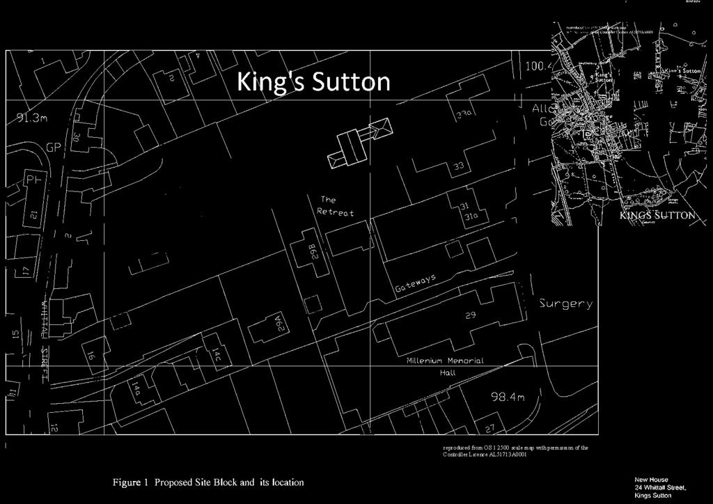
2 1.0 Introduction Dr Isabel Lisboa holds a BA and a PhD in Archaeology from the University of Cambridge. She was a Fellow in Archaeology for two years at the University of London. She worked full-time for four years as Consultant and Project Manager with Tempvs Reparatvm prior to forming Archaeologica twelve years ago. She has written numerous desk-based reports and WSI s for evaluations, excavation and watching briefs for rural and urban sites and produced Heritage Statements for sites in Bedfordshire, Buckinghamshire, Leicestershire,, Nottinghamshire and Oxfordshire. The proposed development consists of the buildings of a new house in the plot if 24 Whittall Street, Kings Sutton, Banbury S/2011/1343/OUT. The location of the development is shown in Fig 1. Kings Sutton lies in the Cherwell valley, 4.5 miles from Banbury and 6.5 miles from Brackley and is a town of Saxon origins but much affected by modern expansion and the proposed development sits in the older part of the town. 2.0 Planning background NPPF National Planning Policy Framework (Department for Communities and Local Government March 2012), NPPF for short, has the concept of sustainable development at its core for both plan-making and decision-taking. One of the 12 core policies states that planning should conserve heritage assets in a manner appropriate to their significance, so they can be enjoyed for their contribution to the quality of life of this and future generations. It replaces 30 planning policy statements and guidance notes and seeks to compress and compartmentalise these statements into a more succinct and easily understood framework for local decision makers to work with when determining future local plan policies and making planning decisions. Paragraph 14 of the NPPF states that at the heart of the National Planning Policy Framework is a presumption in favour of sustainable development. It should be used by Local Authorities for plan making and for decision-taking. For decision-making this means: approving development proposals that accord with the development plan without delay; and where the development plan is absent, silent or relevant policies are out of date, granting permission unless any adverse impacts of doing so would significantly and demonstrably outweigh the benefits, when assessed against the policies in the Framework; or where specific policies in the National Planning Framework indicate development should be restricted, which in terms of Heritage is exemplified by Designated Heritage Assets such as Listed buildings (footnote 9). Section 12 deals with the conservation and enhancement of the historic environment. Paragraph 128 states that in determining applications, local planning authorities should require an applicant to describe the significance of any heritage assets affected, including any contribution made by their setting with footnote 29 stating that the principles and policies set out in this section apply to the heritage-related consent regimes for which local planning authorities are responsible under the Planning (Listed Buildings and Conservation Area) Act 1990 such as Designated Heritage Assets, as well as to plan-making and decision-taking. The level of detail should be proportionate to the assets importance and no more than is sufficient to understand the potential impact of the proposal on their significance 2
3 In the absence of a Local Plan which is up to date and consistent with the Framework, paragraph 26 of the NPPF states that planning applications should be determined in accord with the Framework, including its presumption in favour of sustainable development. The Local Development Framework The Local Development Framework (LDF) for South is a new set of documents which will include all of the planning authority's local development documents. As they are adopted by the Council, they will eventually replace the South Local Plan adopted in South Local Plan adopted in 1997 With regards to conservation areas, the South Local Plan adopted in 1997 states that it follows Section 72 of the Planning (Listed Buildings and Conservation Areas) Act 1990, and that the Council is required to pay special attention to the desirability of preserving or enhancing the character or appearance of a conservation area. This should also be a material consideration in the Council s handling of development proposals which are outside the conservation area but which would affect the its setting, or views into or out of the area. Two policies deal with the Conservation Areas: Policies EV 10 and EV11. EV10 states that the council will seek to preserve or enhance the special character or appearance of conservation areas by: (i) resisting the loss of buildings, walls, trees, hedges or other features and (vi) retaining open spaces and important views, where they contribute to the character of the area. EV11 states that planning permission will not be granted for any development proposals outside a conservation area which have an adverse effect on the setting of the conservation area or on any views into or out of the area. Kings Sutton is identified as a Restricted Fill Village in the south Local Plan. The residential policies make provision on appropriate residential development within the village confines. The centre of the village was Designated a Conservation Area in The limits of the Conservation Area are shown in Appendix HISTORICAL BACKGROUND Kings Sutton appears in Domesday as Suttone. At this time the village had a church, a priest and a market and two mills and was quite prosperous. Bridges (1791) relates that the king had in the parish 6 carucates and two in desmene with 1 servant. 7 villains and 10 cottagers had 2 carucates, it had meadow grounds. It also had a mill and a market. The manor had 4 villains with 2 carucates and a priest held 3 virgates. There were further 2 carucates of arable land with 9 villagers and a mill. It indicates that Kings Sutton was a prosperous parish with a church, a market and two mills. The end of the Civil War saw a period of rebuilding in Kings Sutton and most of the older buildings of Kings Sutton date from this period. Some of Buildings date from the 17 th /18 th century and are Listed Buildings. On July 13th, 1785 a fire spread through much of the town and over 40 houses were burnt. It is thought to have affected the centre of the village. Most of the houses in the older parts of the village were destroyed particularly in the areas around Whittall Street, Astrop Road and 3
4 the Square. The damage was valued at nearly three thousand pounds An Act of Parliament in 1804 paved the way for the enclosure of the remainder of King's Sutton in the following year. Independent Commissioners were appointed to arrange the fair redistribution of land and they produced the Enclosure Award and a Plan Enclosure Map of Transport links increased substantially in the 19 th century with the Canal and later the GWR line, Banbury and Cheltenham section. The Oxford Canal started in 1769 and the section from Banbury to Oxford was completed in Though it passes to the West of the parish through Oxfordshire, it was significant in improving the carriage of freight to the village. The Great Western Railway had completed its line between Oxford and Banbury in 1850 and later this was extended to Birmingham. The effects of the improved communication are visible in the expansion of the village as shown by the comparison between the Enclosure map of 1805 and the 1 st edition OS map of The village had increase by 50 houses between 1801 an 1821 but in the second half of the 19 th century the rate of expansion increased more markedly. In the course of the 19 th century settlement spread along Richmond Street and Astrop Road as shown in the 1 st edition OS map of There was also development in Wales Street, known before the 1950 as Station Road. Much of this development involved construction using red brick. Development proceeded apace in the early 20 th century on the eastern edge of the village with council houses built at Astrop Gardens in 1923 and later in Richmond Street and Newlands. After 1950 the village expanded further with the construction of modern housing and estates along Richmond Street Astorp Road and Banbury Lane when Orchard Way was built linking Richmond Street and Upper Astrop Road. Further development followed at Orchard Way and Dairy Ground. In addition the historic village has seen a substantial amount of new development in the recent past, consisting of brick built properties on small plots carved from earlier larger plots often clustered cul de sac serviced from a major road, as is the case with the back lane of Whittall Street and vacant areas in what were often generously sized plots have resulted in the construction of new houses and bungalows to the side of behind the older houses. The expansion of Kings Sutton since the late 19th century resulted in its the merging with Astrop into a single settlement due to infilling from modern housing. It resulted in a significant change in the geography of the town with the historic core of the village, previously in the centre now lying in the SW edge of the settlement. 4.0 THE SITE AND ITS SETTING The historic settlement of Kings Sutton conforms to the green village type and that open area now sits on the south west of the present day village. This historic core of the village sits on the higher ground of the village. It is centred around the Square flanked by a cluster of listed buildings, the oldest being the church (grade I) where some elements of Norman architecture still survive, which sits on the opposite side to the 15 th century Courthouse (Grade *) and the stocks. The Manor House (grade *) is also located south of the Square. On opposite side sits a row of houses, 9,10,11 the Square, which like the remaining buildings listed under the Planning (Listed Buildings and Conservation Areas) Act 1990 for the village, are Grade listed. The statutorily protected buildings are shown in Appendix 1. 4
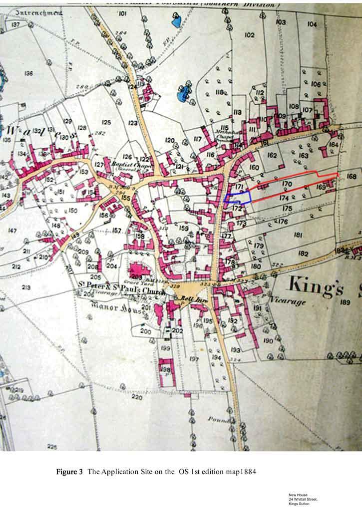
5 The dominant characteristic of the houses dating from the 17 th to the 19 th century is their construction in the vernacular style using local iron stone and slate or tiled roofs though some at least would have been originally thatched and tend to sit directly on the footpath. Whittall Street, known as the High Street until the 1950 s, is one of the streets running off from the Square, heading down towards the north and Home Farm another grade listed building, and Richmond Street and Bull Lane. Red Lion Street and Church Lane run from the west of the Square, the latter also having a clutch of Listed Buildings, all grade. Astrop Road runs eastwards of the Square but is of historical interest only near its intersection with the Square. The conservation area (see Appendix 2) encompasses these streets wholly in some case. In the case of Whittall Street only a ribbon along the western edge of the eastern side of the street is encompassed within the conservation area, to the west and outside the proposed new house. The proposed new house, the Application Site, sits between Whittall Street and its back lane. It is defined to the south and the north by vegetation covered stone walls. To the east by a wooden fence separating the Site from the bungalow formerly part of the same plot. A narrow passage leads to a gate providing access to the back lane. The Site of proposed development sits outside the Conservation Area (Appendix 2). Whittall Street comprises predominantly stone and slate dwellings dating from the 17 th and 18 th century using the local vernacular style. There are many signs of 19 th century changes in architectural detail including 20th century replacement windows. Most of the houses sit directly on the pavement in a near continuous stone façade screening the back of the plots from the street view. There are a few newer buildings of 19 th and 20 th century dates. The comparison between the enclosure map of 1805 an the first edition map surveyed at the close of the 19 th century shows substantial changes in the spatial organisation of the village centre: the later map shows alterations in the backs of the properties along Whittall Street. There is noticeable more infilling in the centre with subdivisions of plots a trend which continues to increase in the centre of the village as shown in the 1900 OS map. With regards to the surrounds of the Whittall Street, the village grew to the East, along Astrop Road and Richmond Street and also to the west along Wales Street. The 1805 Enclosure map (Fig 2) confirms that the oldest part of the village sits around the Square to the SW of the Site. The dense irregular plot patterns to the north of the Square and on either side of Red Lion Street and along Church Lane suggest an early medieval date for the origin of these plots. By contrast, the plots to the north- east of the Square suggest they were set at a later date. They span between the Whittall Street and the back lane in a pattern conforming to later medieval burgage plots. A similar pattern of land division is apparent north of Richmond Street. In the 1805 map (Fig 6 a) the plot of the Application Site (plot 87) is shown to have buildings in the middle of the plot. In plot immediately to the south and adjacent to the Application Site (plot 88) two cottages are shown facing the back lane, showing the start of village infilling had started by the beginning of the 19 th century. By 1884 when the 1 st edition map was drawn there different buildings had been built in the plots of the Application Site and the earlier building had been removed (Fig 6b). The plot to the north of the Site, plot 171 (plot 86 in the 1805 map) had been subdivided so the rear became part of the plot facing Richmond street (163) which now encompasses the previous plot numbered 85 and part 86 of the 1805 map. The 1884 map (Fig 6 b) also shows that the plot to the south of the Application Site had been further subdivided so that in addition to the cottages facing the back land and Whittall Street there was a middle plot (174). 5
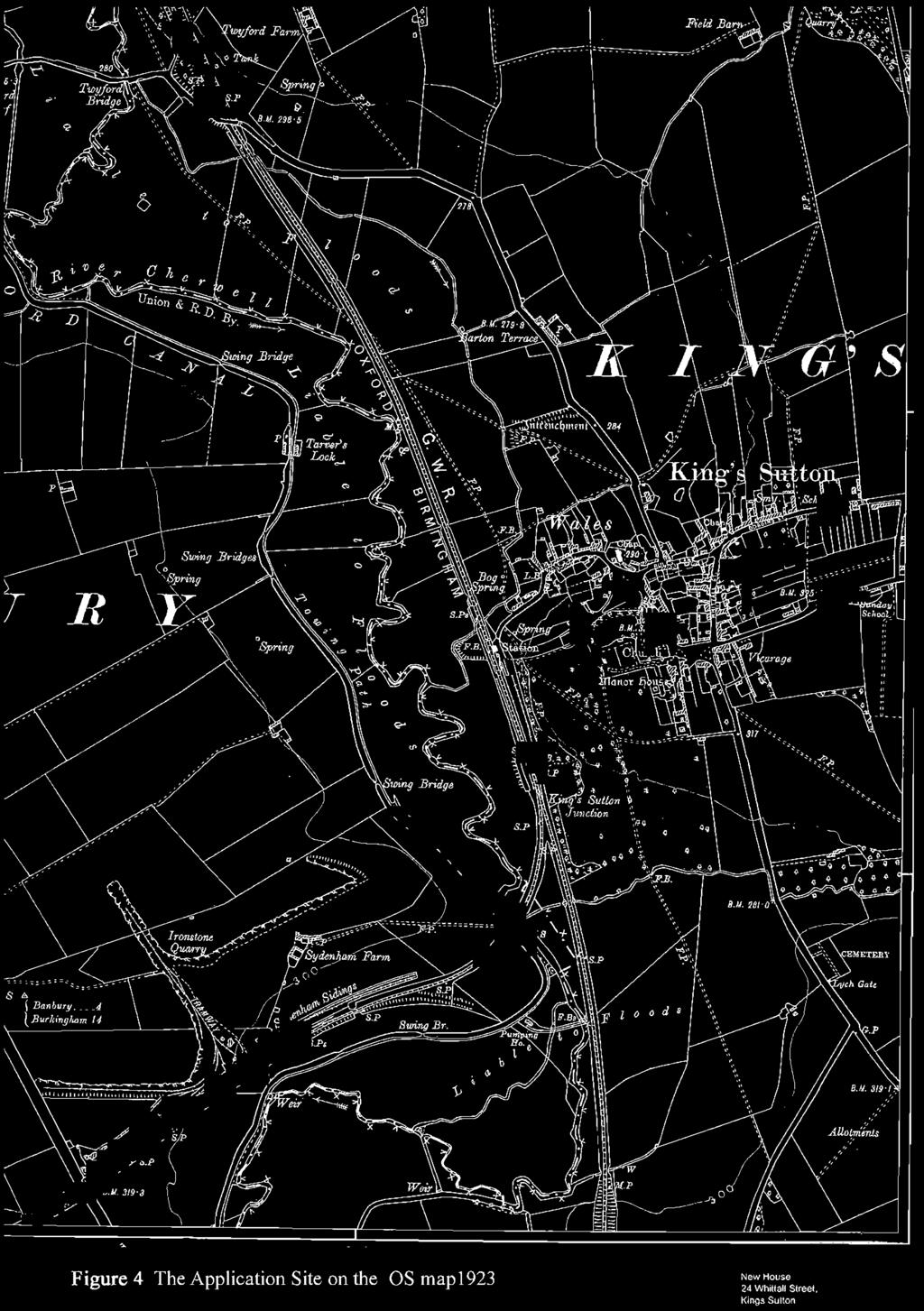
6 This pattern of subdivision of plots had become generalised by the late 19 th century as the 1884 OS map shows affecting practically every plot in the area defined by Richmond Street, Whittall Street, Astrop Road and the back lane of Whittall Street. The dynamic change of plot definition continued into the beginning of the 20 th century affecting the plot of the Application Site itself. The OS 1923 map shows the plot of the Application Site to been internally divided with a building in the middle of the plot (Fig 6c) By the end of the 20 th century all the plots at the back of Whittall Street had buildings built at the rear, opening to the back lane (Fig 6 d). In the case of the Application Site a single storied brick built dwelling was erected, leading to a new division of the plot. 4.0 CONCLUSIONS By the time Parliamentary Enclosure was enacted in 1803 and the Enclosure map drawn in 1805, cottages had started to be built at the back of the plots facing Whittall Street. There were also buildings in the middle of virtually every plot. By 1884 some plots in the area had been subdivided or amalgamated. (Fig 2). The process of internal division of the plots affected the plot of the Application Site as shown in the 1923 OS map (Fig 6c). More recently the plot was divided a second time when the bungalow opening to the back lane was built. It left only a narrow passage along the southern edge of the Site to provide access from the house at 24 Whittall Street to the back lane. The plot of the Application Site has thus been affected by at least two mapped subdivisions in the 20 th century, shown in the 1923 map and in the modern map. Existing impact In terms of existing impact, the Site has been negatively affected by firstly subdivision and secondly the construction of the bungalow at the rear. Its definition and character as a burgage plots has been diminished both in size and its integrity severely compromised so the character of the plot has changed form agricultural to urban. The back lane, where infilling had started by 1805, has now been totally built up so every plot spanning between Whittall Street and the back lane has dwelling/buildings opening directly on the back lane. Most of these buildings are of 20 th century date. The character of the burgage plot landscape where this area was open in order to be used for cultivation and rubbish disposal has therefore disappeared as the area is now built up and the plots have acquired the character of 20 th century built environment. There are no published criteria for the assessment of heritage assets. However there are the set criteria for designated assets. Using those criteria (condition, rarity, character and group value) we can see that the condition of the site is poor in terms of its the medieval historic character since (a) the plot has been subdivided already and it has a house at the back, (b) it has also lost its group value since most of the plots in the block are now subdivided and built up., (c) the plot is not well preserved the eastern boundary is gone and (c) the major boundaries north and south will continue to be fossilised. In addition, the character of the plot and the surrounding plots have changed from rural to urbanised. Therefore the historic significance of the plot is low. In broader terms of setting, the surrounds of the site have largely lost their historic value as they have become urbanised. Kings Sutton itself has lost much of the village character as it has expanded to join Alstrop and as it has been affected both by the construction of housing in the late 19 th century and 20 th modern estates on the edges and considerable infilling in the 6
7 area shown in the 1805 maps. The core historic centre which was the settlement of Kings Sutton now forms the southwestern corner of Kings Sutton, having lost its central place and so it now site on the edge of the village. Future impact The area of the Site has seen a substantial amount of development to the rear of buildings on the street frontage of Whittall Street. The recent additions now line every plot on the back lane. The buildings consist of brick built largely but not solely single storey building different in character from the established character of the Whittall Street frontage. It is also very different in character from the historic character of this area which was as agricultural plots for the street front houses. The delineation of the conservation area reflects this division between the well preserved street frontage of Whittall Street and the much altered, 20 th century character of the back plots. In terms of the setting of the conservation area, the additional house would have little negative impact to the setting of the conservation area given that the character of the back plots which already built up, with houses in the middle and back of the plots. In terms of the existing impact, the existing division of the plot itself, the modern infill, amalgamation of plots and building in every plot around it, has diminished the character of the plot so the heritage value is low and the impact of the proposed development is minor. The heritage value would have been enhanced by the group value of the plot but the map evidence shows that character disappeared as a result of modern building in the rear and middle of the plots and amalgamation of plots particularly between the 1920 s and the late 1970 s. The landscape of the whole block is now a built landscape and the small amount of open area subtracted by the proposed development and the new house would have little further negative impact, given the existing loss of integrity and historic reference within and without the plot. Unlike many of the existing neighbouring developments (where amalgamation of plots has occurred), the major historic boundaries of the plot would be maintained, so the northern and southern boundaries would remain fossilised, further diminishing the impact of the proposed development. There are no Designated Heritage Assets in the surrounds of the Site of Proposed Development, the nearest (Rose Cottage Listed Building Grade ) not being visible form the plot in any case. The buildings in the street front are of local interest. The impact of the proposed house on Designated Assets is null. summary The historic value of the plot has already been compromised internally with the construction of the single bungalow in the rear facing the back lane. A significant part of value of a burgage plot lies in it being part of a group of plots, an organised planned landscape which is how they were set out originally. The plots were set out so as to provide land for the sustenance of the householders in the houses on the street front. That group value has been severely negatively affected by the infilling of the most of the plots in the medieval planned landscape in the area delimited by Whittall Street to the west and Richmond Street, so the integrity of the plots had disappeared by the 1970 and early 1980 s. The proposed development will continue to fossilise the major plot boundaries, to the north and south. The impact of the proposed house on the historic asset is low. In terms of destruction of the integrity of the plot at the rear of 24 Whithall Street, the process of internal division started between 1884 and 1923 and became more profound with the subdivision of the plot and the construction of the bungalow at the rear. 7
8 While the street frontage is well preserved, the setting of the rear of those buildings is now comprises a built environment, not open land, so that the construction of the new dwelling would have little impact in what is already a built, back lane townscape. The new house would not be visible from Whittall Street and would have no impact on this streetscape. References Baker George The History and Antiquities of the County of Northampton vol 2 John Bridges 1791, The History and Antiquities of vol 1 Kings Sutton Village appraisal group Kings Sutton RCHM 1982 County of :archaeological sites vol 4. Enclosure Map 1805 A pan of the parish of Kings Sutton in the county of Northampton NRO 2994 OS inch to the mile 1 st edition LX 6 NRO 2382 OS 6 to 1 mile 1900 XL NW OS 6 to 1 mile 1823 XL NW OS 1: SP 45 NE OS 1: SP 53 NW 8


9

10
11


12


13

14
15 BRIDGE AT KINGS SUTTON LOCK OXFORD CANAL BRIDGE AT KINGS SUTTON LOCK OXFORD CANAL, OXFORD CANAL, Adderbury, Cherwell, Oxfordshire GATEPIERS AT ROAD TO NEWBOTTLE MANOR AT JUNCTION OF NEWBOTTLE AND KINGS SUTTON PARISHES NEWBOTTLE MANOR, GATEPIERS AT JUNCTION OF NEWBOTTLE BOUNDARY GATEPIERS AT ROAD TO NEWBOTTLE MANOR AT JUNCTION OF NEWBOTTLE AND KINGS SUTTON PARISHES, Kings Sutton, South, ASTROP HOUSE ASTROP HOUSE, ASTROP, Kings Sutton, South, * ST RUMBALD'S WELL APPROXIMATELY 70 METRES SOUTH OF ASTROP HOUSE ST RUMBALD'S WELL APPROXIMATELY 70 METRES SOUTH OF ASTROP HOUSE, ASTROP, Kings Sutton, South, WELLHEAD AT SP WELLHEAD AT SP , ASTROP ROAD, Kings Sutton, South, No name for this Entry 2 AND 4, ASTROP ROAD, Kings Sutton, South, OLD LACE HOUSE OLD LACE HOUSE, ASTROP ROAD, Kings Sutton, South, SUTTON HOUSE SUTTON HOUSE, 1, CHURCH AVENUE, Kings Sutton, South, HOME FARMHOUSE HOME FARMHOUSE, RICHMOND FARMHOUSE, Kings Sutton, South, CHURCH OF ST PETER AND ST PAUL CHURCH OF ST PETER AND ST PAUL, THE SQUARE, Kings Sutton, South, I HEADSTONE APPROXIMATELY 5 METRES WEST OF WEST DOORWAY OF CHURCH OF ST PETER AND ST PAUL HEADSTONE APPROXIMATELY 5 METRES WEST OF WEST DOORWAY OF CHURCH OF ST PETER AND ST PAUL, THE SQUARE, Kings Sutton, South, No name for this Entry 9, 10 AND 11, THE SQUARE, Kings Sutton, South, THE COURTHOUSE THE COURTHOUSE, THE SQUARE, Kings Sutton, South, *
16 ROSE COTTAGE ROSE COTTA GE, 1, WHITTALL STREET, Kings Sutton, South, MANOR HOUSE MANOR HOUSE, THE SQUARE, Kings Sutton, South, * CHEST TOMB APPROXIMATELY 4 METRES SOUTH WEST OF WEST DOOR OF CHURCH OF ST PETER AND ST PAUL CHEST TOMB APPROXIMATELY 4 METRES SOUTH WEST OF WEST DOOR OF CHURCH OF ST PETER AND ST PAUL, THE SQUARE, Kings Sutton, South, WHITE HORSE PUBLIC HOUSE WHITE HORSE PUBLIC HOUSE, THE SQUARE, Kings Sutton, South, Q COTTAGE Q COTTAGE, 6, WALES STREET, Kings Sutton, South, STOCKS STOCKS, THE SQUARE, Kings Sutton, South, GATEPIERS AND GATE AT ENTRANCE TO ASTROP PARK GATEPIERS AND GATE AT ENTRANCE TO ASTROP PARK, UPPER ASTROP ROAD, ASTROP, Kings Sutton, South, THE NUTSHELL THE NUTSHELL, 3, CHURCH AVENUE, Kings Sutton, South, No name for this Entry 4, LION STREET, Kings Sutton, South, No name for this Entry 33 AND 35, RICHMOND STREET, Kings Sutton, South, KINGS SUTTON LOCK OXFORD CANAL KINGS SUTTON LOCK OXFORD CANAL, OXFORD CANAL, Adderbury, Cherwell, Oxfordshire Buildings is in Kings Sutton listed under the Planning (Listed Buildings and Conservation Areas) Act 1990 as amended for its special architectural or historic interest. Source: The National Heritage List for England

17
Stanwick Neighbourhood Plan
 Stanwick Neighbourhood Plan Heritage Audit Stanwick Neighbourhood Plan Steering Group August 2015 Purpose of the Heritage Audit It is a core planning principle within National Planning Policy Framework
ARCHAEOLOGICAL S E R V I C E S. Manor Farm, Launton, Bicester, Oxfordshire. Archaeological Watching Brief. by Aiji Castle. Site Code: LBO13/220
 T H A M E S V A L L E Y ARCHAEOLOGICAL S E R V I C E S Manor Farm, Launton, Bicester, Oxfordshire Archaeological Watching Brief by Aiji Castle Site Code: LBO13/220 (SP 6035 2285) Manor Farm, Launton, Bicester,
PLANNING STATEMENT. Market House Market Place Kingston upon Thames KT1 1JS
 PLANNING STATEMENT To support planning and listed building consent applications for change of use from Class A1 shop and Class A3 cafe to Class A3 restaurant at: Market House Market Place Kingston upon
Case Studies; Meitheal Clusters Applied to Villages and Rural Settlements
 Case Studies; Meitheal Clusters Applied to Villages and Rural Settlements 23.3.9 (ii) Case Studies, Meitheal Clusters applied to villages and rural settlments Fig 22.3.12 Cluster site plan; church opposite
Neighbourhood Plan Representation
 Date: 10 th November 2017 Neighbourhood Plan Representation Land to the east of Callow Hill Road, Alvechurch Introduction This representation has been prepared by RPS Planning and Development on behalf
2014/0590 Reg Date 26/06/2014 Chobham
 2014/0590 Reg Date 26/06/2014 Chobham LOCATION: PROPOSAL: TYPE: APPLICANT: OFFICER: ASCOT PARK POLO CLUB, WESTCROFT PARK FARM, WINDLESHAM ROAD, CHOBHAM, WOKING, GU24 8SN Erection of a two storey detached
Derry City and Strabane District Council Planning Committee Report
 Derry City and Strabane District Council Planning Committee Report COMMITTEE DATE: 23 rd March 2016 APPLICATION No: APPLICATION TYPE: PROPOSAL: LOCATION: APPLICANT: LA11/2015/0395/F Residential Development
LONGDEN VILLAGE DEVELOPMENT STATEMENT
 LONGDEN VILLAGE DEVELOPMENT STATEMENT 2017-2027 1 Longden Development Statement 2017-2027 15/01/18 1. Background 1.1 Longden Village Longden village is a very rural and traditional community first mentioned
ARCHAEOLOGICAL S E R V I C E S. Becks, Park Lane, North Newington, Banbury, Oxfordshire. Archaeological Watching Brief.
 T H A M E S V A L L E Y ARCHAEOLOGICAL S E R V I C E S Becks, Park Lane, North Newington, Banbury, Oxfordshire Archaeological Watching Brief by Andy Mundin Site Code: BPN16/105 (SP 4207 3978) Becks, Park
INTRODUCTION CURRENT APPLICATION
 05/01805/FUL & 05/01807/LBC ERECTION OF A SINGLE DWELLING HOUSE WITH ANCILLARY ACCOMMODATION AT Flamingo Zoological Gardens, Olney Road, Weston Underwood FOR Mr A J Crowther (as amended by letter dated
DESIGN & ACCESS STATEMENT
 . DESIGN & ACCESS STATEMENT Site Adjacent to The Manor House, Upper Street,, Kingsdown, Deal, Kent. DESIGNS ARCHITECTURE + PLANNING CONTENTS Design and Access Statement Introduction Site and Location Planning
Conservation Area Designation, amendments and Review
 Conservation Area Designation, amendments and Review Location: Are area largely confined to Cowley Road and North Warpole Way and incorporating the following properties: No.s 2-120 (even) & 61 123 (odd)
Ward: West Wittering. Proposal Change of use from public highway pavement to residential garden use.
 Parish: West Wittering Ward: West Wittering WW/17/03295/FUL Proposal Change of use from public highway pavement to residential garden use. Site Izora 1 Watersedge Gardens West Wittering PO20 8RA Map Ref
5 Gratton Terrace London NW2 6QE. Reference: 17/5094/HSE Received: 4th August 2017 Accepted: 7th August 2017 Ward: Childs Hill Expiry 2nd October 2017
 Location 5 Gratton Terrace London NW2 6QE Reference: 17/5094/HSE Received: 4th August 2017 Accepted: 7th August 2017 Ward: Childs Hill Expiry 2nd October 2017 Applicant: WSD (Gratton) Ltd Proposal: The
APP/G1630/W/15/
 Appeal Decision Site visit made on 20 October 2015 by William Fieldhouse BA (Hons) MA MRTPI an Inspector appointed by the Secretary of State for Communities and Local Government Decision date: 20 November
an Inspector appointed by the Secretary of State for Communities and Local Government
 Appeal Decision Site visit made on 23 January 2017 by Gareth Wildgoose BSc (Hons) MSc MRTPI an Inspector appointed by the Secretary of State for Communities and Local Government Decision date: 6 February
7.1 Area 1: Haslemere Conservation Area
 7.1 Area 1: Haslemere Conservation Area Detailed map of Haslemere Town Conservation Area as of 2006 Crown copyright and database right 2011 Ordnance Survey LA100025451 27 The Conservation Area is characterised
National Character Area 70 Melbourne Parklands
 Summary The are a landscape of rolling farmland, parkland and woodland on the northern flanks of the ridge between Burton upon Trent and Swadlincote. The land slopes down to the River Trent, which borders
SOUTH CAMBRIDGESHIRE DISTRICT COUNCIL. Executive Director (Operational Services) Corporate Manager (Planning and New Communities)
 Corporate Manager (Planning and New Communities)") SOUTH CAMBRIDGESHIRE DISTRICT COUNCIL REPORT TO: Planning Committee 12 January 2011 AUTHOR/S: Executive Director (Operational Services) Corporate Manager (Planning and New Communities) Notes: S/1848/10
SOUTH CAMBRIDGESHIRE DISTRICT COUNCIL REPORT TO: Planning Committee 12 January 2011 AUTHOR/S: Executive Director (Operational Services) Corporate Manager (Planning and New Communities) Notes: S/1848/10
Conservation Area Designation, amendments and Review
 Conservation Area Designation, amendments and Review Location: Any area largely confined to Park Road and St. James Avenue which includes the following properties: St. James Church, St. James Road; No.
Tennis Court Rear Of 3-5 Corringway London NW11 7ED
 Location Tennis Court Rear Of 3-5 Corringway London NW11 7ED Reference: 18/4122/FUL Received: 3rd July 2018 Accepted: 3rd July 2018 Ward: Garden Suburb Expiry 28th August 2018 Applicant: Ms Sarah Robinson
Land to West of Bessel s Way, Blewbury. Contextual Analysis. fluid
 Land to West of Bessel s Way, Blewbury Contextual Analysis fluid Contents fluid - Overview - Growth pattern - Footpath & Road connections - Landscape Character - Amenities - Agriculture - Characteristic
WANSFORD. Village Design Statement. Supplementary Planning Guidance adopted by Peterborough City Council on 22 nd August 2003
 WANSFORD Village Design Statement 2003 Supplementary Planning Guidance adopted by Peterborough City Council on 22 nd August 2003 Prospect of Wansford Bridge, St. Mary s Church and Bridge End, c.1902 Conceived,
NAA SITE REF: HG2-22 CHURCH STREET, BOSTON SPA LEEDS LDF SITE ALLOCATIONS PLAN PRE-SUBMISSION CHANGES (FEBRUARY 2017) HERITAGE REPRESENTATIONS
 HERITAGE REPRESENTATIONS") NAA LEEDS LDF SITE ALLOCATIONS PLAN PRE-SUBMISSION CHANGES (FEBRUARY 2017) HERITAGE REPRESENTATIONS Northern Archaeological Associates Ltd. Marwood House Harmire Enterprise Park Barnard Castle Co. Durham
NAA LEEDS LDF SITE ALLOCATIONS PLAN PRE-SUBMISSION CHANGES (FEBRUARY 2017) HERITAGE REPRESENTATIONS Northern Archaeological Associates Ltd. Marwood House Harmire Enterprise Park Barnard Castle Co. Durham
INTRODUCTION. Land West of Main Road, Stanton Harcourt THE SITE. Why is the Site Suitable for Development?
 0 INTRODUCTION THE SITE Application Boundary Gladman Developments Ltd has successfully invested in communities throughout the UK over the past 0 years, developing high quality and sustainable residential,
Welcome. Land adjacent Sandy Lane WALTHAM CHASE THE PROPOSED SITE
 Land adjacent Sandy Lane WALTHAM CHASE Existing Linden Homes developments Welcome Welcome to Linden Homes Southern s ( Linden ) public exhibition about its proposals for a range of high-quality homes for
Settlement Boundaries Methodology North Northumberland Coast Neighbourhood Plan (August 2016)
") Introduction This background paper sets out a methodology for the definition of settlement boundaries in the North Northumberland Coast Neighbourhood Plan. The neighbourhood plan is planning positively
Introduction This background paper sets out a methodology for the definition of settlement boundaries in the North Northumberland Coast Neighbourhood Plan. The neighbourhood plan is planning positively
CHESHIRE HISTORIC TOWNS SURVEY
 CHESHIRE HISTORIC TOWNS SURVEY Frodsham Archaeological Strategy 2003 CHESHIRE HISTORIC TOWNS SURVEY Frodsham Archaeological Strategy 2003 Environmental Planning Cheshire County Council Backford Hall Backford
Warwickshire County Council. Upper and Lower Brailes. Landscape Study
 Warwickshire County Council Upper and Lower Brailes Landscape Study Produced by WCC Landscape Architects March 2016 Landscape Assessment of Potential Development Sites within the parish of Brailes 1.0
Status of Supplementary Planning Guidance OLD WOKING CONSERVATION AREA Character Appraisal and design Guidance
 Status of Supplementary Planning Guidance OLD WOKING CONSERVATION AREA Character Appraisal and design Guidance Status This Planning Guidance which is supplementary to Policy BE9 of the Woking Borough Local
Clifton Mill. Clifton Oxfordshire
 Clifton Mill Clifton Oxfordshire Clifton Mill Clifton Oxfordshire Approximate distances: Banbury 8 miles (London Marylebone by rail from 55 minutes) Bicester 11 miles (London Marylebone from 40 minutes)
North East Region TYNE & WEAR 1 /315 (B ) NZ
 NZ") TYNE & WEAR Newcastle Upon Tyne 1 /315 (B.05.6311) NZ 28016514 138 FOSSWAY, WALKER An Archaeological Desk-Based Assessment for a Proposed Development at 138 Fossway, Walker GeoQuest Associates Consett
TYNE & WEAR Newcastle Upon Tyne 1 /315 (B.05.6311) NZ 28016514 138 FOSSWAY, WALKER An Archaeological Desk-Based Assessment for a Proposed Development at 138 Fossway, Walker GeoQuest Associates Consett
DEVELOPMENT MANAGEMENT REPORT
 ITEM A08-1 DEVELOPMENT MANAGEMENT REPORT TO: BY: DATE: DEVELOPMENT: SITE: WARD: APPLICATION: APPLICANT: Development Management Committee Development Manager Proposed live/work unit in connection with existing
Planning and Regulatory Committee 20 May Applicant Local Councillor Purpose of Report
 Planning and Regulatory Committee 20 May 2014 7. APPLICATION FOR PLANNING PERMISSION FOR THE CARRYING-OUT OF DEVELOPMENT PURSUANT TO PLANNING PERMISSION REFERENCE NUMBER 603451 DATED 28 FEBRUARY 2007 WITHOUT
DACORUM GOLDEN PARSONAGE Great Gaddesden Brief Description Principal Building: Approach: Stable block other utilitarian buildings: Walled Garden:
 HERTFORDSHIRE GARDENS TRUST LOCAL LIST: DACORUM Present Name of Site GOLDEN PARSONAGE Historic Name (if known) Parish/Town Great Gaddesden National Grid Reference of Principal Building: TL051 125 Present
Oxford Green Belt Study. Summary of Final Report Prepared by LUC October 2015
 Oxford Green Belt Study Summary of Final Report Prepared by LUC October 2015 Project Title: Oxford Green Belt Study Client: Oxfordshire County Council Version Date Version Details Prepared by Checked by
BROADHEMBURY DESIGN STATEMENT
 BROADHEMBURY DESIGN STATEMENT As drawn up by Broadhembury Parish Council during the development of a Parish Plan and adopted at its meeting on 17 th May 2010 BROADHEMBURY DESIGN STATEMENT Contents Introduction
An Introduction to Heritage
 An Introduction to Heritage Presented by Jack Haw & Claire Easton RTPI North West Young Planners Conference November 2017 Contents Introduction Founding of Building Conservation Definition of a Heritage
STRENSALL RAILWAY BUILDINGS CONSERVATION AREA APPRAISAL. In association with Strensall with Towthorpe Parish Council
 STRENSALL RAILWAY BUILDINGS CONSERVATION AREA APPRAISAL In association with Strensall with Towthorpe Parish Council CONTENTS Page 1 Introduction 2 2 Location and Context 3 3 Topography and Setting 4 4
Parish of Repton NEIGHBOURHOOD DEVELOPMENT PLAN
 Parish of Repton NEIGHBOURHOOD DEVELOPMENT PLAN BASIC CONDITIONS STATEMENT December 2018 CEF 4 Legal Requirements This statement has been produced by the NDP Working Group on behalf of Repton Parish Council
STATEMENT OF OBJECTION TO THE PROPOSED DEVELOPMENT OF LAND AT CHURCH CLIFF DRIVE FILEY
 STATEMENT OF OBJECTION TO THE PROPOSED DEVELOPMENT OF LAND AT CHURCH CLIFF DRIVE FILEY You will be aware that Scarborough borough council have adopted a new local plan that includes land at Church Cliff
Plaistow and Ifold Neighbourhood Plan Pre-Submission Consultation Draft
 Mrs Beverley Weddell Clerk to Plaistow And Ifold Parish Council Lock House Lodge Knightons Lane Dunsfold, GU8 4NU. Dear Mrs Weddell, Our ref: Your ref: Telephone Fax HD/P5402/ 01483 252040 18 th October
Public Consultation. Land at Monks Farm, North Grove. Welcome
 Welcome Welcome to our public exhibition for development on Land at Monks Farm, orth Grove. Gallagher Estates and Gleeson Strategic Land are preparing an outline planning application for new homes, open
Exploring Abergavenny
 11 Majors Barn36 Ysguborwen Exploring Abergavenny 2 ysguborwen EXPLORING ABERGAVENNY For several years the Abergavenny and District Civic Society has been studying the streets, spaces and buildings of
Perth and Kinross Council Development Management Committee 24 April 2013 Report of Handling by Development Quality Manager
 Perth and Kinross Council Development Management Committee 24 April 2013 Report of Handling by Development Quality Manager Alterations,Carpenter House, Carpenter Street, Perth, PH1 5GB Ref. No: 13/00303/FLL
Environment Agency Flood Risk Map for the Village of Bridge
 Environment Agency Flood Risk Map for the Village of Bridge December 2016 21 Objective F. Conserving and Enhancing the Natural Environment The National Planning Policy Framework states that the planning
Introduction. Grounds of Objection
 Planning application ref. number 18/04496/APP Planning application to Aylesbury Vale District Council for the erection of 17 dwellings and associated works to the South of Hogshaw Road Granborough. Granborough
DRAFT CONSERVATION AREA APPRAISAL CHAILEY GREEN DESIGNATED
 DRAFT CONSERVATION AREA APPRAISAL CHAILEY GREEN DESIGNATED 16.06.76 DRAFT CHAILEY GREEN CONSERVATION AREA APPRAISAL 1 SUMMARY 1.1 Key Positive Characteristics 1.2 Recommendations 2 INTRODUCTION 2.1 The
DESIGN & ACCESS STATEMENT
 DESIGN & ACCESS STATEMENT Land to the South East of the A495, Bronington Erection of 31 Dwellings (27 dwellings and 4 bungalows including 4 Affordable Dwellings), Realignment and Improvements to A495 (including
HeritageCollectiveLLP
 Appendix C, Review of Archaeology and Cultural Heritage Assessment Introduction 1. This information (SEI) addresses the likely significant impacts of a six-turbine development in which T6 is removed from
Lovells Wood Lillingstone Lovell, Buckinghamshire, MK18 5AZ
 Lovells Wood Lillingstone Lovell, Buckinghamshire, MK18 5AZ Lovells Wood Lillingstone Lovell, Buckinghamshire MK18 5AZ Contemporary, eco-friendly design set in native oak woodland Contemporary design
Cottage Grove. Conservation Area. Character Appraisal
 Positive People - Positive Leadership - Positive Partnerships Cottage Grove Conservation Area Character Appraisal Consideration of Proposal to Designate Grove Avenue and Park Road Chilwell as a Conservation
The eight-week period for this application expires on 5 October 2006.
 06/01213/FUL CHANGE OF USE FROM AGRICULTURAL LAND TO PRIVATE CAR PARK AND NEW FENCING. AT Land To The South of Perceval Almhouses, Lower Weald, Calverton FOR Calverton Parochial Church Council INTRODUCTION
3 Abbey View Mill Hill London NW7 4PB
 Location 3 Abbey View Mill Hill London NW7 4PB Reference: 15/03203/HSE Received: 26th May 2015 Accepted: 16th June 2015 Ward: Mill Hill Expiry 11th August 2015 Applicant: Proposal: Mr Richard Benson Alterations
Ward: Southbourne. Outline application with all matters reserved. Erection of 5 no. dwellings and associated works.
 Parish: Southbourne Ward: Southbourne SB/16/00205/OUT Proposal Site Outline application with all matters reserved. Erection of 5 no. dwellings and associated works. Dunkirk South Lane Southbourne Emsworth
SOUTH CAMBRIDGESHIRE DISTRICT COUNCIL. Planning and New Communities Director
 SOUTH CAMBRIDGESHIRE DISTRICT COUNCIL REPORT TO: Planning Committee 5 June 2013 AUTHOR/S: Planning and New Communities Director S/0747/13/FL HISTON Construction of Car Park at Histon Baptist Church, Station
Land Adj. 63 Sunny Bank Road, Sutton Coldfield, Birmingham, B73 5RJ
 Committee Date: 11/07/2013 Application Number: 2013/03520/PA Accepted: 20/05/2013 Application Type: Full Planning Target Date: 15/07/2013 Ward: Sutton Vesey Land Adj. 63 Sunny Bank Road, Sutton Coldfield,
Final Revisions: Provision of single storey modular classroom and associated works.
 LOCATION: St Catherines Catholic Primary School, Vale Drive, Barnet, Herts, EN5 2ED REFERENCE: B/01924/12 Received: 17 May 2012 Accepted: 28 May 2012 WARD(S): Underhill Expiry: 23 July 2012 Final Revisions:
Appendix 4 - Character Assessment and Design Code. Character Assessment
 Appendix 4 - Character Assessment and Design Code Character Assessment To gain a deeper understanding of the Parish for the Neighbourhood Plan, a Character Assessment of the parish was carried out with
26 Park West Exploring Abergavenny
 26 Park West Exploring Abergavenny Cover: Park Avenue 2 park west EXPLORING ABERGAVENNY For several years the Abergavenny and District Civic Society has been studying the streets, spaces and buildings
an Inspector appointed by the Secretary of State for Communities and Local Government
 Appeal Decision Site visit made on 6 November 2017 by Rachel Walmsley BSc MSc MA MRTPI an Inspector appointed by the Secretary of State for Communities and Local Government Decision date: 19 th January
Designations protecting the historic designed landscape
 Historic Landscape Project Designations protecting the historic designed landscape A. Key national designations affecting the historic environment: 1. Listed buildings 2. Scheduled Monuments (generally
PART 1 EAST HAMPSHIRE DISTRICT COUNCIL SECTION 1 SCHEDULE OF APPLICATION RECOMMENDATIONS
 PART 1 EAST HAMPSHIRE DISTRICT COUNCIL PLANNING COMMITTEE REPORT OF THE HEAD OF PLANNING Applications to be determined by the Council as the Local Planning Authority SECTION 1 SCHEDULE OF APPLICATION RECOMMENDATIONS
Conservation Area Designation, amendments and Review
 Conservation Area Designation, amendments and Review Location: No.s 37-49 (odd) Twickenham Road Date Assessed: January 2018 Adjacent Conservation Area Significance: Teddington Lock CA. The Teddington Lock
Derry City and Strabane District Council Planning Committee Report
 Derry City and Strabane District Council Planning Committee Report COMMITTEE DATE: 29 th November 2017 APPLICATION No: APPLICATION TYPE: PROPOSAL: LOCATION: APPLICANT: AGENT: LA11/2016/0854/O Outline Shared
Babergh and Mid Suffolk Joint Draft Local Plan Consultation, August 2017, Public Consultation
 Babergh and Mid Suffolk Joint Draft Local Plan Consultation, August 2017, Public Consultation Having reviewed the documents, the Society has made the following response: Housing Delivery Q 7. Do you agree
DRAFT/02. Our Place. Westbury-on-Trym. City Design Group. July 2013 City Design Group
 DRAFT/02 City Design Group Contents Preface 1. Introduction 2. Character and distinctiveness 3. Character Areas 1 Henbury Road environs 2 Commercial core 3 College and Church Road environs 4 Channell
Midcounties Co-operative Society Ltd.
 Llanago, Old Radnor, Presteigne, Powys LD8 2RP T. 01544 350520 M. 07444 311421 info@thegriffithsheritageconsultancy.co.uk www.thegriffithsheritageconsultancy.co.uk Tuffins / Co-op Supermarket, Knighton,
SOUTH CAMBRIDGESHIRE DISTRICT COUNCIL. Executive Director / Corporate Manager - Planning and Sustainable Communities
 SOUTH CAMBRIDGESHIRE DISTRICT COUNCIL REPORT TO: Planning Committee 4 th July 2007 AUTHOR/S: Executive Director / Corporate Manager - Planning and Sustainable Communities S/0520/07/F - STAPLEFORD Erection
VIEW PLANS AT: mmary&keyval=ny3yzlhy0b100
 HARROGATE BOROUGH COUNCIL 09/6.49.165.A.OUT /15/05195/OUT/0 09/6.49.165.A.OUT /15/05195/OUT/1 DATE: 12 May 2016 PLAN: 09 CASE NUMBER: 15/05195/OUT GRID REF: EAST 416110 NORTH 465707 APPLICATION NO. 6.49.165.A.OUT
Case Officer: Sarah Kay File No: CHE/14/00515/REM Tel. No: (01246) Plot No: 2/6132 Ctte Date: 15 th September 2014 ITEM 1
 Plot No: 2/6132 Ctte Date: 15 th September 2014 ITEM 1") Case Officer: Sarah Kay File No: CHE/14/00515/REM Tel. No: (01246) 345786 Plot No: 2/6132 Ctte Date: 15 th September 2014 ITEM 1 APPROVAL OF RESERVED MATTERS FROM APPLICATION CHE/12/00234/OUT (1) LAYOUT,
Case Officer: Sarah Kay File No: CHE/14/00515/REM Tel. No: (01246) 345786 Plot No: 2/6132 Ctte Date: 15 th September 2014 ITEM 1 APPROVAL OF RESERVED MATTERS FROM APPLICATION CHE/12/00234/OUT (1) LAYOUT,
Report Author/Case Officer: Joanne Horner Contact Details:
 APP 04 Application Number: 16/00140/FUL Other Two storey side extension to existing dwelling and formation of hard standing to provide parking for number 54 (Resubmission of withdrawn application 15/02852/FUL)
LEEDS SITE ALLOCATIONS PLAN MATTER 3 GREEN BELT KCS DEVELOPMENT AUGUST 2017
 LEEDS SITE ALLOCATIONS PLAN MATTER 3 GREEN BELT KCS DEVELOPMENT AUGUST 2017 Smith Limited Suite 9C Joseph s Well Hanover Walk Leeds LS3 1AB T: 0113 2431919 F: 0113 2422198 E: planning@peacockandsmith.co.uk
Neighbourhood Planning Local Green Spaces
 Neighbourhood Planning Local Green Spaces Introduction... 2 1. Why green space is important... 4 2. Neighbourhood plans and green space... 6 3. Evidence... 8 Statutory designations... 9 Green space audit...
an Inspector appointed by the Secretary of State for Communities and Local Government
 Appeal Decision Site visit made on 21 October 2014 by Jacqueline Wilkinson Reg. Architect IHBC an Inspector appointed by the Secretary of State for Communities and Local Government Decision date: 29 October
MID SUFFOLK DISTRICT COUNCIL DEVELOPMENT CONTROL COMMITTEE A - 09 November (1) The application site is owned by Mid Suffolk District Council.
 The application site is owned by Mid Suffolk District Council.") MID SUFFOLK DISTRICT COUNCIL DEVELOPMENT CONTROL COMMITTEE A - 09 November 2016 I AGENDA ITEM NO APPLICATION NO PROPOSAL SITE LOCATION SITE AREA (Ha) APPLICANT RECEIVED EXPIRY DATE 1 2776/16 Erection of
MID SUFFOLK DISTRICT COUNCIL DEVELOPMENT CONTROL COMMITTEE A - 09 November 2016 I AGENDA ITEM NO APPLICATION NO PROPOSAL SITE LOCATION SITE AREA (Ha) APPLICANT RECEIVED EXPIRY DATE 1 2776/16 Erection of
Warren Farm, Ampthill
 1 Welcome The developers of the Warren Farm site, Bloor Homes and Connolly Homes, are holding this exhibition on the emerging Design Codes for the development prior to their formal submission to Central
Planning Department Dover District Council Council Offices White Cliffs Business Park Dover Kent CT16 3PJ. Our Ref: MB/LP/11002.
 Planning Department Dover District Council Council Offices White Cliffs Business Park Dover Kent CT16 3PJ Our Ref: MB/LP/11002 1 June 2016 Dear Sir/Madam, RE LINWOOD YOUTH CENTRE, 92 MILL ROAD, DEAL, CT14
Site ref: AS06 Site Name or Address: Murreys Court, Agates Lane
 Site ref: AS06 Site Name or Address: Murreys Court, Agates Lane Proposed Land Use: Total Site Area (Ha): Housing 1.85 Ha Description: It is understood that the owner has no plans to dispose of the site
Character Area Summary 6: Canal Zone Stonehouse Town Character Assessment, Bridgend Works from Downton Road
 Character Area Summary 6: Canal Zone An open area, with residential and industrial areas, which has a rural character and a rich historic and natural environment strongly influenced by the Stroudwater
UTT/17/2075/FUL - (BERDEN) (Referred to Committee by Councillor Janice Loughlin. Reason: In the Public Interest)
 (Referred to Committee by Councillor Janice Loughlin. Reason: In the Public Interest)") UTT/17/2075/FUL - (BERDEN) (Referred to Committee by Councillor Janice Loughlin. Reason: In the Public Interest) PROPOSAL: LOCATION: APPLICANT: Amendments to the design of a scheme for a 49.99MW battery
UTT/17/2075/FUL - (BERDEN) (Referred to Committee by Councillor Janice Loughlin. Reason: In the Public Interest) PROPOSAL: LOCATION: APPLICANT: Amendments to the design of a scheme for a 49.99MW battery
SOUTH CAMBRIDGESHIRE DISTRICT COUNCIL. REPORT TO: Planning Committee 1 April 2015 Planning and New Communities Director
 SOUTH CAMBRIDGESHIRE DISTRICT COUNCIL REPORT TO: Planning Committee 1 April 2015 AUTHOR/S: Planning and New Communities Director Application Number: Parish(es): Proposal: Site address: Applicant(s): Recommendation:
Archaeological Evaluation and Assessment of Land at Kent Cottage, 19 Chapel Street, Hythe, Kent
 Archaeological Evaluation and Assessment of Land at Kent Cottage, 19 Chapel Street, Hythe, Kent Planning Application Y13/0463/SH Date of Report: 29/04/2015 Report for Marc Carney SWAT. ARCHAEOLOGY Swale
design & access statem ent PROPOSED REPLACEMENT DWELLING 10 PARK LANE, APPLETON
 design & access statem ent PROPOSED REPLACEMENT DWELLING 10 PARK LANE, APPLETON INTRO DUCTION The applicant for this site, 10 Park Lane, Appleton is seeking full planning permission for proposed demolition
3. Neighbourhood Plans and Strategic Environmental Assessment
 1. Introduction This report sets out a draft Screening Determination for the Preston Parish Council s Neighbourhood Plan and has been prepared by rth Hertfordshire District Council. The purpose of the
ENVIRONMENTAL INVENTORY
 Hungarton Neighbourhood Plan ENVIRONMENTAL INVENTORY Sites scoring 25/36 or more (70%) are judged to be the most important environmental and community sites and are proposed as Local Green Space. Other
STATEMENT OF CASE. Interested party. Whitmore Parish Council and Baldwins Gate Action Group. 15 July 2014
 Site address Land at the end of Gateway Avenue, Baldwins Gate, Newcastleunder-Lyme, Staffordshire Description of development Erection of up to 113 dwellings and associated works Application reference 13/00426/OUT
New horse training area, Manor Farm, Great Kimble, Buckinghamshire
 New horse training area, Manor Farm, Great Kimble, Buckinghamshire An Archaeological Watching Brief For Redwing Structures (Marlow) Limited by Andy Taylor Thames Valley Archaeological Services Ltd Site
11.1 INTRODUCTION. The characteristics of these areas are briefly discussed below.
 SECTION 11 : HERITAGE PRECINCTS 11.1 INTRODUCTION This section applies to some areas within the Residential and Business Resource Areas. The significant resource management issues for this section are
2015/1020 Mr Edward Cockburn Caravan storage on hardcore base (Retrospective) Ranah Stones, Whams Road, Hazlehead, Sheffield, S36 4HT
 Ranah Stones, Whams Road, Hazlehead, Sheffield, S36 4HT") 2015/1020 Mr Edward Cockburn Caravan storage on hardcore base (Retrospective) Ranah Stones, Whams Road, Hazlehead, Sheffield, S36 4HT Dunford Parish Council have not commented Councillor Andrew Millner
2015/1020 Mr Edward Cockburn Caravan storage on hardcore base (Retrospective) Ranah Stones, Whams Road, Hazlehead, Sheffield, S36 4HT Dunford Parish Council have not commented Councillor Andrew Millner
DONCASTER METROPOLITAN BOROUGH COUNCIL. PLANNING COMMITTEE - 15th October Expiry Date:
 DONCASTER METROPOLITAN BOROUGH COUNCIL PLANNING COMMITTEE - 15th October 2013 Application 3 Application Number: 13/01158/FUL Application Expiry Date: 31st July 2013 Application Type: Full Application Proposal
PLANNING COMMITTEE 15 September 2015
 AGENDA ITEM NO 12 PLANNING COMMITTEE 15 September 2015 APPLICATION NUMBER : CA//15/01402/FUL PROPOSAL : Single-storey conservatory to rear. LOCATION OF SITE : 5 Mill Lane, Herne, CT6 7ED APPLICATION TYPE
Reference: 16/1234/HSE Received: 25th February 2016 Accepted: 2nd March 2016 Ward: High Barnet Expiry 27th April 2016
 Location 7 Sunset View Barnet EN5 4LB Reference: 16/1234/HSE Received: 25th February 2016 Accepted: 2nd March 2016 Ward: High Barnet Expiry 27th April 2016 Applicant: Proposal: Mr & Mrs Peter & Anny Woodhams
SOUTH CAMBRIDGESHIRE DISTRICT COUNCIL. Planning and New Communities Director
 SOUTH CAMBRIDGESHIRE DISTRICT COUNCIL REPORT TO: Planning Committee 9 January 2013 AUTHOR/S: Planning and New Communities Director S/2270/12/FL FEN DRAYTON 850m long flood defence embankment ranging in
UPPER GORDON ROAD TO CHURCH HILL, CAMBERLEY CONSERVATION AREA
 Introduction This leaflet explains the purpose of conservation areas and the implication of their designation for residents, property owners and the Council. It provides you with a plan of the area and
Report Author/Case Officer: Paul Keen Senior Planning Officer (Dev Control) Contact Details:
 Contact Details:") APP 03 Application Number: 17/02060/FUL Description A full planning application for the demolition of an existing bungalow (C3 use class) and associated out buildings and the erection of two, two storey
APP 03 Application Number: 17/02060/FUL Description A full planning application for the demolition of an existing bungalow (C3 use class) and associated out buildings and the erection of two, two storey
VILLAGE OF BOLTON HERITAGE CONSERVATION DISTRICT PLAN
 Page 1 1. INTRODUCTION AND BACKGROUND 1.1 THE PROJECT VILLAGE OF BOLTON HERITAGE CONSERVATION DISTRICT PLAN TERMS OF REFERENCE The Town of Caledon (Town) is a large, predominantly rural municipality with
ENVIRONMENTAL AND LANDSCAPE MAPPING
 APPENDIX IV : Environmental and Landscape Mapping ENVIRONMENTAL AND LANDSCAPE MAPPING Calveley Neighbourhood Plan November 2016 ENVIRONMENTAL AND LANDSCAPE MAPPING Calveley Neighbourhood Plan Calveley
Historic England Advice Report 26 August 2016
 Case Name: Kingsland Castle Case Number: 1435892 Background Historic England has been asked to review the scheduling for Kingsland Castle. The land on which the monument lies is understood to be for sale.
New House Farm, Risbury, Nr Leominster, Herefordshire
 New House Farm, Risbury, Nr Leominster, Herefordshire A beautiful farmhouse and numerous extremely versatile outbuildings, in extensive gardens and paddocks with superb views. 7 Acres LOCATION Leominster