2 CONTENTS ABOUT... PAGE 3 HISTORY... PAGE 4-7 MAPS... PAGE RESOURCES... PAGE RIVERFRONT DEVELOPMENT... PAGE GALLERY... PAGE G
|
|
|
- Claude Charles
- 5 years ago
- Views:
Transcription


1 1
2 2 CONTENTS ABOUT... PAGE 3 HISTORY... PAGE 4-7 MAPS... PAGE RESOURCES... PAGE RIVERFRONT DEVELOPMENT... PAGE GALLERY... PAGE GET INVOLVED... PAGE 19
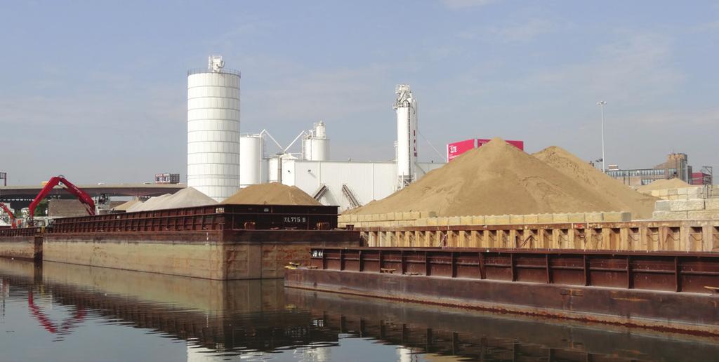
3 3 ABOUT The Pilsen-Little Village River Corridor Project was established in 2014 to develop a master plan that will result in a healthier, more accessible Chicago Sanitary and Ship Canal corridor from Bubbly Creek to west of Pulaski Road on Chicago s southwest side. It is the goal of this project not only to improve the environmental quality of this section of the Chicago River System, but to elevate it to a cherished public amenity. Haunted by a complex history of contamination and neglect, this 3.3 mile reach of river is also impacted by present day pollution from combined sewer ove flows, storm water runoff, permitted industrial inputs, and a lack of public open space. Despite these challenges, the river, which is bordered by Bridgeport, Pilsen, Little Village, Brighton Park, Archer Heights, McKinley Park, and South Lawndale, presents a great opportunity for revitalization and community enhancement. A long term plan that results in clean water, capping or removing toxic sediments, eliminating odors, improving native landscapes, creating fish habitat, and developing open space would make the river safer for people and wildlife, and connect the river to the community. The intent of this project is to view this long segmented section of the river as a single unit. This section of the river can serve as the organizing principle around which we may consider how to creatively establish a healthy recreational corridor, eventually bringing the same kind of attention and investment to it that other reaches have received. The project area starts at Bubbly Creek with Park 571 and Canal Origins Park and continues downstream to include the Canalport Riverwalk, the Richard J. Daley Boat Launch, the recently shuttered Fisk and Crawford sites, Parcel S, Park 553, the Collateral Channel and any other open spaces that can become part of the amenity mosaic. Considering the recent announcement by the City of Chicago to invest over $100 million in a downtown river-walk project, the time is ripe to address the remediation of the water and revitalization of the riverfront properties adjacent to the Chicago Sanitary and Ship Canal and even consider renaming it. Our goal is to ensure that the wider public is aware of its environmental condition, the need for access to riverfront public spaces for healthy recreation and leisure activities, and that they know they can be a part of the solution by advocating for change.
4 4 HISTORY CHICAGO SANITARY AND SHIP CANAL Completed in 1900 by the Chicago Sanitary District (now MWRD) to reverse the Chicago River, to prevent Chicago s waste from polluting its water supply, the Chicago Sanitary and Ship Canal has long been neglected. For many decades this reach of the river system has remained severely contaminated. Vulnerable to industrial wastes and raw sewage, the Chicago Sanitary and Ship Canal presents environmental dangers to surrounding community and is limited in its value as public open space and habitat for the wildlife that calls the river home. The canal s name is indicative of its reputation. Yet, times have changed and so has the Chicago Sanitary and Ship Canal. Studies show that fish are now abundant here. In 2010 young channel cats were found, indicating the canal is becoming appropriate habitat for spawning. As the water quality has improved, the canal has also become more of a recreational asset. New public parks, boat launches, and riverwalks along the banks are drawing more residents out this section of the river than ever before. It is time to focus on the canal and making the kinds of investments that will truly transform it into a community asset. PILSEN Pilsen is one of Chicago s oldest neighborhoods. The origins of the community steam from the same project that turned Chicago from a small frontier outpost into a the nation s second city - the building of the Illinois and Michigan (I & M) Canal. The South Branch of the Chicago river connects with the South Fork (now Bubbly Creek) along Pilsen s southern border. To the communities west, the river used to terminate in a series of marshy wetlands. Today these wetlands are replaced by concrete and the man-made Chicago Sanitary and Ship Canal which replaced the I & M in Ever since the construction of the I & M, Pilsen has been an immigrant, working class community, one of Chicago s most important port-of-entry neighborhoods.
5 5 In the late 19th Century, Bohemian (Czech) immigrants replaced the original Irish and German canal diggers. In the early 20th century Poles became the predominate group. But starting in the 1950 s it was Mexican immigrants that became dominant and gave the community its current culture and character. Each ethnic group that has called Pilsen home have contributed a chapter to Pilsen s two centuries of social, economic, political and environmental struggles. From the revolt of the Potawatomi in the 1812, to the Battle of the Viaduct in 1877, to the events leading up to the Haymarket incident in 1883, to the 1910 garment workers general strike, to the struggle for a neighborhood high school in the 1970 s, to the recent marches for immigrant rights, Pilsen has always been a community in struggle. Today, Pilsen residents hope to turn one of those struggles, the decade long fight to close the Fisk coal fired power plant, into a new era in the neighborhoods history. The closure of Fisk in 2012 was a major victory for the people of Pilsen, but residents now hope to take the victory a step further by turning a piece of the Fisk property into Pilsen s first point of public access to the South Branch of the Chicago river. LITTLE VILLAGE Like Pilsen, Little Village has also witnessed tremendous community and ethnic transformations throughout the decades. During the early twentieth century Little Village was located at the outskirts of the city. With the expansion of industrial production outside of the central business district, Little Village quickly became a central site of manufacturing in Chicago. Anchored by an industrial corridor that stretches along the north side of the Chicago Shipping and Sanitation Canal, the community was home to several large scale factories, including the Crawford Coal power plant. During the era of industrialization, Little Village was predominantly populated by European immigrants. Beginning in the 1960s and 70s many people of Mexican descent moved into the community. Currently, Little Village is a thriving Latino community with almost 90,000 residents living in five square miles. Unfortunately, many families live at or below the poverty level; 98% of the school children in HISTORY
6 6 public schools qualify for the free lunch program. Thirty percent of Little Village residents are under 18, and thirty-one percent are undocumented. Due to population density and histories of de-industrialization, the community severely lacks open space and has hundreds of brownfield sites. Little Village is also bordered by a major expressway and is exposed to toxic fumes from thousands of diesel trucks that pass through the area everyday. Despite the many challenges that families in Little Village face, the community has fought hard for environmental justice. In 2012 neighbors successfully organized to close down the Crawford coal power plant which was the source of respiratory and health problems in the neighborhood for so long. In 2014, community members are turning their attention to the environmental conditions of the Collateral Channel and the development of open space in the area. For many decades the 31st Collateral Channel has remained severely contaminated and is the source of great embarrassment. Vulnerable to industrial wastes, and raw sewage, the waterway presents great environmental dangers to surrounding community members. BUBBLY CREEK The long time environmental degradation of Bubbly Creek, or the South Fork of the Chicago River s South Branch, has everything to do with the historic use of the area. What once was a wetland, the area Bubbly Creek would eventually occupy was dredged in the 1800 s to dry out the surrounding area for the purpose of development by diverting flow to the Chicago River. In the early 1900 s this location lied in close proximity to the Chicago Stockyards, Chicago s growing meatpacking industry. The meatpacking industry used the channel as a dumping ground for animal waste products. The continuous buildup of this material resulted in the condition to which the creek owes its name. As the organic material decomposed it started to de-gas, releasing bubbles of methane and hydrogen sulfide that floated up to the surface and still do. A century later, Bubbly Creek continues to live up to its name. Other than rainwater, the vast majority of the flow channel receives comes from combined sewer overflows, which can rush out of the Racine Avenue Pump Station (which lies at the south end of the channel) at 6,000 CFS during strong storm events. HISTORY
7 7 The specific conditions of the creek have rendered it a challenge for remediation but federal support, in the form of a study by the U.S. Army Corps of Engineers (due out this summer), brings new hope to the waterway s clean up. New water quality standards are pending before the Illinois Pollution Control Board under rulemaking R regarding portions of the Chicago River system. LITTLE VILLAGE COLLATERAL CHANNEL The Collateral Channel in Little Village shares many of the same problems that plague Bubbly Creek. In a study of the channel the Metropolitan Water Reclamation District notes, Due to historical industrial, municipal, and CSO discharges into the Collateral Channel, the water and sediment have been compromised to the point where the waterway is no longer usable by humans or wildlife. The flow within the upper channel is stagnant 99% of time. Over the past decade the Collateral Channel received some attention and preliminary efforts were made to remediate the waterway. Unfortunately, these initial steps were soon stalled. Due to its smaller size, there is now hope that once a solution is developed to manage the remediation of Bubbly Creek, it may be scaled down to suit the needs of Collateral Channel. Unlike Bubbly Creek, little has been done to allow for public access and recreation at this site. Due to the poor water quality of the waterway, there are days in the summer when the scent of the channel becomes unbearable. The highly anticipated Park 553 will be constructed across from the dead end of the channel at 31st street. This park will bring desperately needed green space and recreational area to a long-deserving neighborhood and it would be a shame if the smell caused to be it unusable and potentially unsafe. The Collateral Channel provides a unique opportunity to create fish and bird habitat and transform into a natural oasis. HISTORY
8 DES PLANINES RIVER 8 MIDDLE FORK NORTH BRANCH SKOKIE RIVER Maps LAKE MICHIGAN WEST FORK NORTH BRANCH SKOKIE LAGOONS O HARE AIRPORT FOREST PRESERVE NORTH SHORE CHANNEL NORTH BRANCH CHICAGO RIVER GOOSE ISLAND MAIN SEWER NAVY PIER SOUTH BRANCH CHICAGO RIVER DES PLAINES RIVER MIDWAY AIRPORT CHICAGO SANITARY & SHIP CANAL BUBBLY CREECK FOREST PRESERVE CALUMENT RIVER MILL CREEK LAKE CALUMET ILLINOIS INDIANA TINLEY CREEK MIDLOTHLAN CREEK
9 9
10 10
11 11 RESOURCES Our Liquid Asset, The Economic Benefits of a Clean Chicago River Chicago River Corridor Development Plan US Army Corps of Engineers webpage for Bubbly Creek OTHER RESOURCES: If you have suggestions that should be added to this list of important links and documents, please send them to krice@chicagoriver.org PEOPLE: Friends of the Chicago River, Action Plan for the Chicago River NPS, Canoe and Kayak Launch Design Guide Chicago River Water Trails Getting to the Chicago River (Trails) Chicago Riverwalk Michigan Avenue Fish Hotel
12 12 WILDLIFE: Chicago s Nature and Wildlife Plan Native Plant Use and Value Center for Neighborhood Technology, Natural Resource Conservation Solutions Chicago Wilderness, Biodiversity Recovery Plan Chicago Wilderness, Atlas of Biodiversity Chicago Metropolitan Agency for Planning: Environment and Natural Resources From Stockyards to Spawning Beds The Sustainable Sites Initiative GENERAL: Chicago River Agenda Chicago Climate Action Plan GREEN INFRASTRUCTURE: USEPA Green Infrastructure Case Studies RESOURCES
13 13 WATER: Green River Pattern Book City of Chicago Water Agenda City of Chicago: Water Conservation City of Chicago River Corridor Development Plan City of Chicago: Center for Green Technology IEPA: Non-point Source Unit (Stormwater Management) Lake County Stormwater Management Commission: BMP Publications Lake County Stormwater Management Commission: North Branch Watershed Page USEPA: Stormwater Management Program USEPA: Clean Water Act Module (Tutorial) USGS Water Alert: Instant Information Sign Up USEPA: WaterSense - Test your knowledge and learn more RESOURCES
14 14 RIVERFRONT DEVELOPMENT The City of Chicago illustrates the value of the Chicago River in the Chicago Zoning Ordinance by requiring all new development within 100 feet of the Chicago River be subject to special review and approval by the City of Chicago Department of Planning and Development, the Chicago Plan Commission, and the City of Chicago Council. In addition, the ordinance requires that new developments be set back a minimum of 30 feet from the river. In the case of Bubbly Creek, this setback is increased to a minimum of 60 feet. These required setbacks were put in place for the specific purpose of stormwater management and environmental protection of the river and its banks. Unlike other locations in the waterway system, Bubbly Creek requires a setback that is two times larger than that of the rest of the river. The Metropolitan Water Reclamation District s Racine Avenue Pump Station is located at the end of Bubbly Creek. The combination of the design of the City s sewer system and Bubbly Creek s unique usage history, require special accommodations so that there is an improvement in functionality and water quality. During heavy storm events, 14 pumps drain 30 square miles of some of the most densely populated area of the county. This immense amount of water commonly includes Combined Sewer Overflows (CSO s), adding untreated sewage to the already poorly drained creek. To reach this point, the riverbank must be rebuilt. The reservation of additional green space along Bubbly Creek will be used to implement healing stormwater management practices that will provide a critical opportunity to improve the water quality of the creek. Setting a development back from the river doesn t mean the space is left alone. To rebuild the riverbank, the soil needs to be held in place, meaning that there should be a considerable amount of vegetation. Not only do roots hold soil where it is, but they help water infiltrate into the ground instead
15 15 of pooling on the surface. Plants native to Illinois are especially suited to this task due to their lengthy root systems. When completed, the setback along Bubbly Creek will have the look and feel of a public park, with gardens of native plants, shrubs, and trees, swales to capture stormwater, and a multi-use Riverwalk trail. Not only will the setback aid in the improvement of the water quality of Bubbly Creek and the surrounding environment, but it will also provide much needed green space and public access to the Chicago River to the surrounding community for generations to come. RIVERFRONT DEVELOPMENT DEVELOPMENT ZONE URBAN GREEN ZONE RIVERBANK ZONE BUBBLY CREEK MINIMUM OF 60 FEET


16 GALLERY BUBBLY CREEK 16


17 17 GALLERY COLLATERAL CHANNEL


18 18 GALLERY RIVERFRONT DEVELOPMENT
 PILSEN ENVIRONMENTAL RIGHTS AND REFORM ORGANIZATION Website: www.pilsenperro.")
19 19 GET INVOLVED For more information and to learn how to support this project please contact the following partner organizations: (LVEJO) LITTLE VILLAGE ENVIRONMENTAL JUSTICE ORGANIZATION Contact: Antonio Lopez, Executive Director Website: (PERRO) PILSEN ENVIRONMENTAL RIGHTS AND REFORM ORGANIZATION Website: FRIENDS OF THE CHICAGO RIVER Contact: Maddie Mahan, Policy and Planning Specialist Website: CHICAGO LEGAL CLINIC Contact: Keith Harley, Environmental Law Program Director Website: SPECIAL THANKS We would like to thank Patagonia for helping LVEJO bring this project to life by providing us with a generous grant.
PUBLIC NOTIFICATION PLAN
 VILLAGE OF LA GRANGE, ILLINOIS NPDES PERMIT NO. ILM580009 COMBINED SEWER OVERFLOW PUBLIC NOTIFICATION PLAN NATIONAL POLLUTANT DISCHARGE ELIMINATION SYSTEM PROGRAM ILLINOIS ENVIRONMENTAL PROTECTION AGENCY
DRAFT. Waterfronts and Open Spaces. 10 The Riverfront Open Space System
 CHAPTER 4 Waterfronts and Open Spaces 10 The Riverfront Open Space System 12 Planned, proposed and envisioned riverfront recommendations. Figure 4.3.23 The riverfront will become a major new public amenity
BE WATER WISE. Managing Your Onlot Stormwater. Sept. 23, 2006 Watershed Weekend
 BE WATER WISE Managing Your Onlot Stormwater Sept. 23, 2006 Watershed Weekend 2006 1 All water resources are interrelated through the Hydrologic Cycle Sept. 23, 2006 Watershed Weekend 2006 2 What is Storm
One County s Success in Linking Watershed Protection and Land Use Planning
 One County s Success in Linking Watershed Protection and Land Use Planning Bob Thompson Porter County Plan Commission March 28, 2012 Indiana Watershed Leadership Academy Population 160,000 Approximately
Camden SMART Initiative Stormwater Management and Resource Training
 Camden SMART Initiative Stormwater Management and Resource Training www.camdensmart.com Camden s Struggle with Stormwater 1 The City of Camden is served by a combined sewer system, which uses the same
PEOPLE, WATER, AND WILDLIFE: BLUE PRINCIPLES FOR RIVER DESIGN
 PEOPLE, WATER, AND WILDLIFE: BLUE PRINCIPLES FOR RIVER DESIGN Category One: People Protecting and Enhancing the Quality of Life Role of the Chicago River People and the River For many, the connection between
Principles for Ecological Landscape Design in Brownfield Business Parks
 Principles for Ecological Landscape Design in Brownfield Business Parks Part of USDA Forest Service research project # 00-JV-11231300-033: Aligning Social and Ecological Drivers of Urban Landscape Change
DRAFT ROOSEVELT ROAD. District Recommendations. Figure 5.23 The Roosevelt Road Corridor
 CHAPTER 5 Figure 5.23 The Road Corridor Road will develop as a mixed-use corridor, emphasizing regional retail, west of the river and mixed-use development east of the river. KEY RECOMMENDATIONS 1. High
E x E C U T I v E S U M M A R y / P L A N N I N G C O N T E x T 14 //
 14 // executive summary / planning context COMMUNITY GREENING PLAN PLANNING CONTEXT Capital Region Water has entered into a partial consent decree with the United States Department of Justice to address
Green Infrastructure The Indianapolis Greenways Connection
 Green Infrastructure The Indianapolis Greenways Connection Fewer things in the transportation industry today make better since than combining the needs for pedestrian and bike trails with the need to locate,
VACANT TO VIBRANT : GREEN INFRASTRUCTURE & URBAN REVITALIZATION
 VACANT TO VIBRANT : GREEN INFRASTRUCTURE & URBAN REVITALIZATION Calumet Summit 2013: Connecting for Action Lauren Riga, Director City of Gary Department of Green Urbanism Gary Storm Water Management District
Climate Smart Communities Green Infrastructure Case Studies
 New York State Water Resources Institute Climate Smart Communities Green Infrastructure Case Studies Emily Vail Hudson River Estuary Program NYS Department of Environmental Conservation Cornell University
KISHWAUKEE MUNICIPALITIES PLAN FOR SUSTAINABLE DEVELOPMENT
 KISHWAUKEE MUNICIPALITIES PLAN FOR SUSTAINABLE DEVELOPMENT 4 "Natural areas, parks and open space create a high quality of life that attracts tax-paying businesses and residents to communities." Trust
Bristol Marsh Heritage Conservancy
 Bristol Marsh Heritage Conservancy The Pennsylvania Environmental Council (PEC) protects and restores the natural and built environments through innovation, collaboration, education and advocacy. PEC believes
Homeowners Guide to Stormwater BMP Maintenance
 Homeowners Guide to Stormwater BMP Maintenance What You Need to Know to Take Care of Your Property Rain Barrel Dry Well Rain Garden Pervious Asphalt Porous Pavers City of El Monte Stormwater BMP Management
Just The Basics: Illicit Discharge. What does it mean to me?
 Just The Basics: Illicit Discharge What does it mean to me? What is an Illicit Discharge? An illicit discharge is the discharge of pollutants or non-storm water materials to storm water drainage systems
EXISTING PLANS Harriet Festing Center for Neighborhood Technology Midlothian Community Meeting March 12, 2015
 EXISTING PLANS Harriet Festing Center for Neighborhood Technology Midlothian Community Meeting March 12, 2015 BENEFITS Bring economic, community + environmental benefits Enhance property values Use
CHAPTER 8 ISSUES, CONCERNS, CONSTRAINTS AND OPPORTUNITIES
 CHAPTER 8 ISSUES, CONCERNS, CONSTRAINTS AND OPPORTUNITIES Introduction This River Conservation Plan was developed during a time of tremendous activity and effort in planning the transformation of the Delaware
Technical Memorandum 5
 Technical Memorandum 5 Environmental Resources August 2015 PREPARED BY AECOM Table of Contents Introduction... 3 Natural Features... 6 Watersheds... 6 Rivers, Lakes, Creeks... 6 Wetlands... 8 Floodplains...
2011 ASLA Design Awards. Westside Creeks Restoration Plan Merit Award AECOM, Fort Collins. Planning & Urban Design
 2011 ASLA Design Awards Westside Creeks Restoration Plan Merit Award AECOM, Fort Collins Planning & Urban Design Project Fact Sheet Category of Entry: Rotating Specialty Award: 2011 2011 ASLA Colorado
Project. Project Type:
 Canal Pilot Streetend Sponge Park Location: Brooklyn, New York, NY Client: New England Interstate Water Pollution Control Commission Design Firm(s): DLandstudio LLC Landscape architect/project contact:
2011 ASLA Design Awards. Coyote Gulch Honor Award and Land Stewardship Designation Valerian LLC. Environmental Restoration and Reclamation
 2011 ASLA Design Awards Honor Award and Land Stewardship Designation Valerian LLC Environmental Restoration and Reclamation Project Name: Category : Project Location: 5 2011 Environmental Restoration and
Rouge River Gateway Master Plan Update: 2011
 Rouge River Gateway Master Plan Update: 2011 Environmental Stewardship Cultural Heritage Recreation Economic Development Rouge Gateway Master Plan (2001) 1 Rouge Gateway Master Plan Update (2005) Significant
CHAPTER 5: GUIDING PRINCIPLES
 CHAPTER 5: GUIDING PRINCIPLES The following 10 principles were developed based on public consultation, planning policy and the background analysis conducted during Phase 1. The Guiding Principles significantly
Phase II Storm Water Permit Program MS4 Permit
 Phase II Storm Water Permit Program MS4 Permit Karen Katamay Environmental Protection Engineer/CPESC Illinois EPA Des Plaines Regional Office karen.katamay@illinois.gov 847-294-4043 Types of Storm Water
Potential Green Infrastructure Strategies May 6, 2015 Workshop
 Potential Green Infrastructure Strategies May 6, 2015 Workshop Background The City of Cortland is developing the Tioughnioga Urban Headwaters Green Infrastructure Action Plan with funding from the National
Green Infrastructure. NYS Department of Environmental Conservation
 Green Infrastructure Green infrastructure is an interconnected network of natural areas and open spaces that sustains ecosystems. Benedict, M.A. and E.T. McMahon. 2006. Green Infrastructure Linking Landscapes
Deer Creek Watershed Stakeholders Committee
 Deer Creek Watershed Stakeholders Committee Stakeholder Partners East West Gateway Council of Governments Great Rivers Greenway District Local Municipalities Metropolitan St. Louis Sewer District Missouri
Pittsfield Action Plan (West Branch of the Housatonic River)
") An initiative of the Massachusetts Executive Office of Energy and Environmental Affairs in partnership with the City of Pittsfield Pittsfield Action Plan (West Branch of the Housatonic River) The spring
An initiative of the Massachusetts Executive Office of Energy and Environmental Affairs in partnership with the City of Pittsfield Pittsfield Action Plan (West Branch of the Housatonic River) The spring
HAZARD MITIGATION GOALS AND OBJECTIVES
 SEWRPC Community Assistance Planning Report No. 282, 2nd Edition CITY OF MILWAUKEE ALL HAZARDS MITIGATION PLAN UPDATE Chapter IV HAZARD MITIGATION GOALS AND OBJECTIVES [NOTE: Throughout this plan update
Meeting Agenda. 1. Introductions (5 min)
") Meeting Agenda Monaca, PA Ohio River Brownfields Redevelopment Planning Federal/State/Regional Partners Meeting June 5, 2012; 3-4pm EDT Conference call-in #: 1-866-299-3188 Conference code: 202 566 0633#
Meeting Agenda Monaca, PA Ohio River Brownfields Redevelopment Planning Federal/State/Regional Partners Meeting June 5, 2012; 3-4pm EDT Conference call-in #: 1-866-299-3188 Conference code: 202 566 0633#
Great Plans for a Great City
 CHAPTER 1 Great Plans for a Great City 1 Figure 1.1 South Michigan Avenue today Figure 1.2 South Michigan Avenue will be one of many higher intensity, mixed-use corridors that will extend out from the
Issues, Challenges & Opportunities
 Below is a summary of issues, challenges, and opportunities relating to the revitalization of Downtown Romeoville and potential development of the Village s East Side TOD Area. Current Issues & Challenges
Industrial Corridor Modernization Little Village
 Industrial Corridor Modernization Little Village Rahm Emanuel, Mayor David Reifman, Commissioner Dept. of Planning and Development Working Group April 26, 2018 dpd@cityofchicago.org cityofchicago.org/dpd
Greenways as an alternative to traditional infrastructure. Green Infrastructure
 Greenways as an alternative to traditional infrastructure Green Infrastructure What is a Greenway? Little (1990) - A linear open space along a natural or human made corridor. Fabos - linked corridors nature
Physical Approaches to Flood Mitigation
 Physical Approaches to Flood Mitigation ational Academy of Sciences /19/2017 Chicago Area Before Development Widespread Flooding Waterways and Marshes Absorbent Ground Early settlers came to this location
March 30, 2017
 March 30, 2017 2 municipal examples of GI installments: Lancaster, PA (population: 60,000) Dover, NH (population 31,000) The City of Lancaster: Overview Incorporated in 1742 as a borough and in 1818
Sustainable Stormwater Management through Green Infrastructure. Jersey City Public School #5
 Green Infrastructure Site Evaluation Friday, October 25 th, 2013 Sustainable Stormwater Management through Green Infrastructure Jersey City Public School #5 FORMAT: (15 minutes) An Introduction to Stormwater
Brigitte A. Berger, Director of Engineering
 Brigitte A. Berger, Director of Engineering Wilmette s Sewer System Overview of Wilmette s Sewer System Green vs. Gray? Stormwater Action Plan Regulatory Compliance Why Homes Flood What can
Natural Shorelines. for Inland Lakes. A Landowner s Guide to using. to STABLIZE SHORELINES, Michigan s inland lakeshore.
 Natural Shorelines for Inland Lakes A Landowner s Guide to using NATURAL MATERIALS to STABLIZE SHORELINES, IMPROVE WATER QUALITY and ENHANCE WILDLIFE HABITAT along Michigan s inland lakeshore. Natural
Toronto Complete Streets Guidelines
 Toronto Complete Streets Guidelines 108 110 7.1 Green Infrastructure Design Principles 112 7.2 Context-Sensitive Green Streets 114 7.3 Key Green Street Elements Green infrastructure refers to natural and
LOUISIANA STATE UNIVERSITY COMPREHENSIVE & STRATEGIC CAMPUS MASTER PLAN. APPENDIX G - Stormwater Study Findings & Stormwater Solutions
 LOUISIANA STATE UNIVERSITY COMPREHENSIVE & STRATEGIC CAMPUS MASTER PLAN APPENDIX G - Stormwater Study Findings & Stormwater Solutions LSU: MP Narrative July 2017 3.5 Open Space Existing Conditions The
Appendix E: Illustrative Green Infrastructure Examples
 Appendix E: Illustrative Green Infrastructure Examples Integrating LID into San Francisco s Urban Landscape Figure E. High-density Residential Figure E. Low-density Residential Figure E. Mixed Use 7 Figure
Examples of Asset Based Approaches to Development. Economic and Community Development Suffield, CT
 Examples of Asset Based Approaches to Development Presented by: Patrick McMahon, Director of Economic and Community Development Suffield, CT Neighborhood Commercial Development Wilson, CT Issues Elevated
Introduction. Integrating Ecological Restoration of Estuarine Shorelines with Urban Community Revitalization Efforts. Ed Morgereth Biohabitats, Inc.
 Introduction Integrating Ecological Restoration of Estuarine Shorelines with Urban Community Revitalization Efforts Ed Morgereth Biohabitats, Inc. 5 th National Conference & Expo on Coastal and Estuarine
City of Elmhurst. City of Elmhurst. Storm Sewer System Workshop November 22, 2010
 City of Elmhurst City of Elmhurst Storm Sewer System Workshop November 22, 2010 1 City of Elmhurst Watershed divide (green dashed line) through Elmhurst Area east of divide drains to Addison Creek Area
Poisoned Park? How Exide s Lead Contamination Risks Frisco s Grand Park
 Frisco City Hall has big plans to transform Stewart Creek into a Grand Park with lots of water features for kids to play in. Poisoned Park? How Exide s Lead Contamination Risks Frisco s Grand Park But
Planning for Staten. Habitat Restoration and Green Infrastructure. Island s North Shore
 Habitat Restoration and Green Infrastructure Planning for Staten Island s North Shore Community Board 1 March 1, 2018 NYC Parks Forestry, Horticulture, and Natural Resources Funded by the NYS Department
SALISBURY TOMORROW Our Vision
 SALISBURY TOMORROW Our Vision Salisbury is committed to supporting a high quality of life and sense of community for all residents. These commitments need to be reflected in our community programs, services
CHAPTER 4 FUTURE LAND USE AND URBAN SERVICES DISTRICTS
 CHAPTER 4 FUTURE LAND USE AND URBAN SERVICES DISTRICTS Introduction This chapter discusses how Benzie County should grow and change in the future. A community can grow and change in many different ways.
Adopt-A-Creek. You are the solution to water pollution.
 Respect the property line. You are the solution to water pollution. Adopt-A-Creek Avoid polluting, dumping or draining to your creek. Respect the natural habitat. The Santa Clara Valley Water District
Department of Community Development. Planning and Environmental Review Division Revised Notice of Preparation
 Department of Community Development Michael J. Penrose, Acting Director Divisions Building Permits & Inspection Code Enforcement County Engineering Economic Development & Marketing Planning & Environmental
Tentatively Selected Plan within Harlem River, East River and Western Long Island Sound Planning Region. First Level Costs. Federal Non-Federal Total
 HARLEM RIVER, EAST RIVER AND WESTERN LONG ISLAND SOUND PLANNING REGION Flushing Bay and Creek Ecosystem Restoration Source Feasibility Study Background Study Resolution (1994), Reconnaissance Report (1996),
McDaniel Creek Master Plan
 McDaniel Creek Master Plan UNIVERSITY AVE., PITTSBURGH NEIGHBORHOOD AND THE MCDANIEL CREEK WATERSHED 60 ANSLEY MALL AND THE CLEAR CREEK GREENWAY 61 INTRODUCTION The BeltLine Subarea 6 site lies within
Shoreland Zoning. Kay Lutze Shoreland Zoning Policy Coordinator
 Shoreland Zoning Kay Lutze Shoreland Zoning Policy Coordinator Kay.Lutze@wisconsin.gov Purposes of shoreland zoning include Prevent and control water pollution Protect spawning grounds, fish and aquatic
Reconnecting to a Forgotten River St. Cloud MN. Aaron Hanson Design Design Thesis LA 572, Thesis, Spring 2012
 Reconnecting to a Forgotten River St. Cloud MN Aaron Hanson Design Design Thesis LA 572, Thesis, Spring 2012 site context 2.5 Miles Sartell St. Cloud to Fargo 170 Miles (2 hrs 45 mins) Hwy 10 infrastructure
Village of Forest Park. July 27, Sewer Separation Evaluation
 Village of Forest Park July 27, 2015 Sewer Separation Evaluation Presentation Overview Study Background Historic Nature of Forest Park Drainage Scale of Flooding Problem Forest Park Sewer System Background
Benefits of Native Vegetation. Presented by: Mary Beth Falsey DuPage County Senior Wetland Technician
 Benefits of Native Vegetation Presented by: Mary Beth Falsey DuPage County Senior Wetland Technician Turf to Prairie-why would I do that? Improved water quality Soil stabilization and absorption Goose
City of Iowa City Department of Neighborhood and Development Services Department of Parks and Recreation Department of Public Works City Manager s
 RFP Pre-submittal meeting December 18, 2015 City of Iowa City Department of Neighborhood and Development Services Department of Parks and Recreation Department of Public Works City Manager s Office Background
CY-FAIR ISD Exemplary-rated schools
 -ACRE master planned community GREEN SPACE within a quarter-mile of every home -SQ.FT. community center CY-FAIR ISD Exemplary-rated schools Located in Cypress, Texas, Bridgeland is northwest Houston s
Small Town Sustainable Stormwater Solutions
 Small Town Sustainable Stormwater Solutions Kathryn Hamilton, RLA, ASLA Westmoreland Conservation District PA/DE ASLA Annual Meeting April 8-9, 8 2011 Urban, Industrial, Residential, Agricultural Flooding,
Urban runoff in my neighborhood (Capitol Hill) is heavy with trash and other debris.
 is heavy with trash and other debris.") South Platte River Meeting Comments & s #1 I am a huge fan of river areas and would love the Platte and surrounding waterways to improve to allow habitat for wildlife and recreation opportunities for citizens.
South Platte River Meeting Comments & s #1 I am a huge fan of river areas and would love the Platte and surrounding waterways to improve to allow habitat for wildlife and recreation opportunities for citizens.
Scorecard. WaterQuality. Appendix B USEPA WATER QUALITY SCORECARD APPENDIX B
 Appendix B USEPA WATER QUALITY SCORECARD EPA 231B09001 October 2009 http://www.epa.gov WaterQuality Scorecard Incorporating Green Infrastructure Practices at the Municipal, Neighborhood, and Site Scales
CHAPTER ONE INTRODUCTION
 1.0 Introduction Bellingham s central waterfront is in a state of transition from its long history as an active industrial site to a new mixed-use neighborhood. Over the past several years, the Port of
Green Bus Tour. International Water Association. Sponsored by the Metropolitan Sewer District of Greater Cincinnati and Greater Cincinnati Water Works
 International Water Association Sponsored by the Metropolitan Sewer District of Greater Cincinnati and Greater Cincinnati Water Works Cincinnati is gaining a national reputation in the sustainable management
Summer Public Education and Outreach Campaign Toolkit
 Summer Public Education and Outreach Campaign Toolkit ABOUT THIS TOOLKIT The communications tools and messages included in this toolkit were developed by Bluestem Communications for the Lower DuPage River
Monitoring and Documenting Green Stormwater Best Management Practices
 Monitoring and Documenting Green Stormwater Best Management Practices Steve Wise - Natural Resources Program Manager Bill Eyring - Senior Engineer Illinois Sustainable Technology Center April 6, 2010 The
green Infrastructure in the Milwaukee Region
 green Infrastructure in the Milwaukee Region 14 MMSD has a long history of environmental stewardship and has implemented holistic approaches to improve water quality and protect residents from the effects
Draft Impervious Cover Reduction Action Plan for West Long Branch Borough, Monmouth County, New Jersey
 Draft Impervious Cover Reduction Action Plan for West Long Branch Borough, Monmouth County, New Jersey Prepared for West Long Branch Borough by the Rutgers Cooperative Extension Water Resources Program
INTRODUCTION TO GREEN INFRASTRUCTURE HOW WE CAN PROTECT OUR COMMUNITIES AND OUR WATERS Maywood Public Library Bergen County, New Jersey
 INTRODUCTION TO GREEN INFRASTRUCTURE HOW WE CAN PROTECT OUR COMMUNITIES AND OUR WATERS Maywood Public Library Bergen County, New Jersey Jeremiah D. Bergstrom, LLA, ASLA Rutgers Cooperative Extension Water
Post Construction BMPs
 Post Construction BMPs Why are Post Construction BMPs important? With increased development brings the increase of impervious cover Parking lots, rooftops, driveways Storm water runoff volume increases
DISCUSSION TOPIC: ST JOHNS RIVER & ITS TRIBUTARIES (BPII) 2030 COMPREHENSIVE PLAN POLICES AND REGULATORY FRAMEWORK
 2030 COMPREHENSIVE PLAN POLICES AND REGULATORY FRAMEWORK") DISCUSSION TOPIC: ST JOHNS RIVER & ITS TRIBUTARIES (BPII) 2030 COMPREHENSIVE PLAN POLICES AND REGULATORY FRAMEWORK St. John s River & Its Tributaries Issue Summary: The St. Johns River is an important
DISCUSSION TOPIC: ST JOHNS RIVER & ITS TRIBUTARIES (BPII) 2030 COMPREHENSIVE PLAN POLICES AND REGULATORY FRAMEWORK St. John s River & Its Tributaries Issue Summary: The St. Johns River is an important
Storm Water Quality and Shoreline Restoration Improvements - Grant Funding Request City of Mound Carlson Park Bolton & Menk Project No.
 September 15, 2016 Brett Eidem Cost Share Grant Administrator Minnehaha Creek Watershed District 15320 Minnetonka Boulevard Minnetonka, MN 55345 RE: Storm Water Quality and Shoreline Restoration Improvements
An Ambitious Plan: Transforming the blighted South Platte River and surrounding environment into Denver s greatest natural resource.
 CONNECTING THE PEOPLE TO THEIR RIVER SOUTH PLATTE RIVER VISION IMPLEMENTATION PROGRAM: GRANT-FRONTIER PARK TO OVERLAND POND PARK REACH The South Platte River Vision Implementation Program (River Vision)
EXECUTIVE SUMMARY EXECUTIVE SUMMARY
 1 EXECUTIVE SUMMARY EXECUTIVE SUMMARY Penn s Landing is envisioned as a welcoming riverfront green space adjacent to a refurbished civic marina becoming the centerpiece for adjacent development. With a
Presented By: Matt Roberts and Cass Chapman The University of Minnesota Law School Environmental Sustainability Clinic
 Presented By: Matt Roberts and Cass Chapman The University of Minnesota Law School Environmental Sustainability Clinic Overview Who We Are and MIDS Project The Problem Recommendations Benefits to Communities
Chelsea Creek Municipal Harbor Plan
 Chelsea Creek Municipal Harbor Plan Public Meeting #1 June 11th, 2018 1 Presentation outline I. Introduction: Why are we doing this plan? II. Evolution of Chelsea Creek III. State of Chelsea Creek IV.
I-290 Eisenhower Expressway
 I-290 Eisenhower Expressway From west of Mannheim Road to Racine Avenue SECTION 7.0 List of Agencies, Organizations, and Persons Receiving FEIS List of Agencies, Organizations and Persons Receiving FEIS
Rainscaping. Rainscaping includes rain gardens, bioswales, combinations of. A guide to local projects in St. Louis
 Rainscaping A guide to local projects in St. Louis Rain garden on South Grand Boulevard in the city of St. Louis. Rainscaping includes rain gardens, bioswales, combinations of plantings, water features,
PRINCIPLE 6: Preserve open space, farmland, natural beauty, and critical environmental areas
 HOW TO APPLY SMART GROWTH PRINCIPLES TO RURAL COMMUNITIES PRINCIPLE 6: Preserve open space, farmland, natural beauty, and critical environmental areas A product of AND A cooperative publication from the
{Best Practices. Summary of Tools, Strategies and Best Practices from 11 Michigan Case Study Communities
 Case Studies Michigan Coastal Community Working Waterfronts { Summary of Tools, Strategies and from 11 Michigan Case Study Communities Table of Contents Zoning...2 Community and Stakeholder Collaboration
A citizen s guide to the. Comprehensive Plan. City of Lakeville, Minnesota 1
 A citizen s guide to the Comprehensive Plan 2008 City of Lakeville, Minnesota 1 Introduction The City of Lakeville completed an update of its Comprehensive Plan in 2008. A comprehensive plan is a tool
Conserving Illinois North Shore Ravines
 Conserving Illinois North Shore Ravines Rebecca Grill, Natural Areas Manager, Park District of Highland Park, rgrill@pdhp.org Jeff Boeckler, Principal Water Resource Specialist, Northwater Consulting,
Rain Gardens. A Welcome Addition to Your Landscape
 Rain Gardens A Welcome Addition to Your Landscape Where Does The Rainwater Go? Naturally, forests provide a way for rainwater to percolate into the soil, filtering pollutants while trees are allowed to
Planned Manufacturing District Review
 Mayor Emanuel s Industrial Corridor Modernization Planned Manufacturing District Review North Branch Framework Implementation Chicago Plan Commission July 20, 2017 Rahm Emanuel, Mayor David Reifman, Commissioner
10.0 Open Space and Public Realm
 10.0 Open Space and Public Realm 10.0 Open Space and Public Realm The Public Open Space System is comprised of: outdoor spaces available for public use that are either publicly owned (e.g., parks and
Detroit. Quick Facts. Who City of Detroit General Services Department. Staff More than 20 staff members
 Wisconsin Michigan Illinois Indiana Ohio Detroit Quick Facts Who City of Detroit General Services Department Staff More than 20 staff members Canopy 22.5 percent canopy cover; an inventory is underway
Greenscape Challenge Toolkit
 Greenscape Challenge Toolkit Take the Greenscape Challenge: https://www.surveymonkey.com/r/greenscapechallenge Yard maintenance and water quality When it rains, fertilizers, pesticides and other chemicals
The Planning Partnership Baird + Associates TCI Management Consultants Ltd. Plan B Natural Heritage Wills Consulting Engineers Poulos & Chung Limited
 Little Lake Master Plan The Planning Partnership Baird + Associates TCI Management Consultants Ltd. Plan B Natural Heritage Wills Consulting Engineers Poulos & Chung Limited May 26, 2009 Purpose of Study
GUIDELINES FOR ECOLOGICAL PERFORMANCE
 3 Landscape........................................... 3.2 Stormwater Management................................... 3.3 Hardscape........................................... 3.4 Streetscape..........................................
Sustainability and Urban Nature An Introduction to Roosevelt University and Exploration of the Chicago River. Mike Bryson
 Sustainability and Urban Nature An Introduction to Roosevelt University and Exploration of the Chicago River Mike Bryson Sustainability Studies Program at RU CIMBY Student Visit / Campus Tour 12 July 2013
Mary Norwood. Mayoral Forum on Greenspace Responses
 1. What do you believe is the single most pressing issue impacting Atlanta s urban forest and greenspace, and how would you solve that issue? Preserving and Protecting Atlanta s forest cover Lungs of Atlanta
PARKS AND OPEN SPACE PARKS AND OPEN SPACE
 Purpose General Findings Goals Early Action Create New Parks Connect the City to the Riverfront Invest in a Sustainable Riverfront PARKS AND OPEN SPACE 6 PARKS AND OPEN SPACE Port Richmond Riverfront Park
Zoning Ordinance Article 3
 Article 3 Natural Resources Protection Section 301 Natural Resources Protection 301.1. Purpose - The following natural resources protection standards are established to protect the public health, safety
Craven Street Stormwater Improvement Projects
 Craven Street Stormwater Improvement Projects The Craven Street Watershed drains the area from Haywood Road to Westwood Place and down Haywood to the French Broad River. The watershed has one main un-named
Sustainable Storm Water Management
 Incorporating Water Management into the Community Planning Process August 16, 2012 Sustainable Storm Water Management Samantha Brown Environmental Engineer SD1 SD1 s Service Area CVG Airport SD1 Service
Gaining Consensus for Green Infrastructure Rain to Recreation
 Gaining Consensus for Green Infrastructure Rain to Recreation May 2nd, 2017 Tom Jacobs, PE, CFM Stormwater Engineer City of Lenexa Ronald L Norris, PE, PWLF Affiliated with Shockey Consulting Rain to Recreation:
SUSTAINABILITY PLAN OTTAWA COUNTY PARKS AND RECREATION COMMISSION FALL 2017
 SUSTAINABILITY PLAN OTTAWA COUNTY PARKS AND RECREATION COMMISSION FALL 2017 Table of Contents Introduction Natural Resources Quality of Life Community Continuing the Mission Sustainability Measuring Sustainability
THE SPATIAL PLAN AND THE LANDSCAPE IN CZECH REPUBLIC
 THE SPATIAL PLAN AND THE LANDSCAPE IN CZECH REPUBLIC 13th ELC Conference, 2 3 October, Cetnjie, Montenegro Ing. Igor Kyselka CSc., Institute for spatial development, Jakubské náměstí 3, 60200 Brno, tel.:
Innovations in Stormwater Management New Frontiers
 Innovations in Stormwater Management New Frontiers Milt Rhodes, CNU AICP Director, Office of Planning and Environmental Sustainability Town of Bluffton, SC mrhodes@townofbluffton.com Town of Bluffton -