An audit of the surface water outfalls in parts of the River Brent Catchment - Outfall Safari
|
|
|
- Adam Wilkinson
- 5 years ago
- Views:
Transcription


1 An audit of the surface water outfalls in parts of the River Brent Catchment - Outfall Safari April 2017 UK & Europe Conservation Programme Zoological Society of London Regent's Park London, NW1 4RY marineandfreshwater@zsl.org s-rivers
2 Acknowledgements This project, funded by The Postcode Local Trust and City Bridge Trust, has been delivered on behalf of the Brent Catchment Partnership in partnership with the London Wildlife Trust, Thames 21 and Brent River Environment Action Support. It would not have been possible without the help of all the dedicated volunteers who collected the data. Special thanks go to Phil Alford. Introduction Misconnected wastewater pipework, cross-connected sewers and combined sewer overflows are a chronic source of pollution in urban rivers. An estimated 3% of properties in Greater London are misconnected (Dunk et al., 2008) sending pollution, via outfalls, into the nearest watercourse. At the moment there is no systematic surveying of outfalls in rivers to identify sources of pollution and to notify the relevant authorities. The Outfall Safari is a survey method devised to address this evidence gathering and reporting gap. It was created by the Citizen Crane project steering group which consists of staff of Thames Water, Environment Agency (EA), Crane Valley Partnership, Friends of River Crane Environment, Frog Environmental and the Zoological Society of London (ZSL). It was first used on the River Crane in Aims The aims of the Brent Outfall Safari were to: record and map the dry weather condition behaviour of surface water outfalls in the Dollis Brook and Silk Stream assess the impact of the outfalls and report those that are polluting to the Environment Agency and Thames Water build evidence on the scale of the problem of polluted surface water outfalls in Greater London recruit more volunteers and further engage existing volunteers in the work of the Brent Catchment Partnership. 1
3 Method The survey of outfalls was conducted between the 1 st and 31 st of March Twenty six people took part in the Outfall Safari, comprising twenty four volunteers and one member of Environment Agency and ZSL staff. Volunteers were trained at the Welsh Harp Environmental Education Centre. Training included: an overview of water quality issues in the Brent catchment information on outfalls and how they become polluted instruction on how to assess each outfall using the project App and how to upload information to the database a health & safety briefing and signing of the risk assessment During the training, groups of volunteers were assigned lengths of the Dollis Brook to survey. Further coordination of survey dates and reaches was conducted by the volunteer group on a closed Facebook group set up specifically for the Outfall Safari. Groups of volunteers were free to conduct the survey of their reach when convenient to them, within the survey period, provided there had been no rain for 48 hours prior to survey. A period of 48 hours of no rain is required before any survey work as rainfall and high surface water flows can obscure the negative impacts of outfalls by washing away sewage fungus, discoloured sediments and rag. The sections of the Brent Catchment surveyed were: Dollis Brook (12km), Mutton Brook (3.5km), Folly Brook (4km) and Silk Stream (5km). The majority of the survey work was conducted from the riverside path (see Figure 1a), with the occasional need to enter the river to properly assess and photograph an outfall. The risk assessment for riverside outfall surveying highlighted the need to assess conditions in the river before entering it and stressed that volunteers should only enter the river channel if the level was lower than Wellington boot depth (c.35cm). During the training volunteers were also shown images of Giant Hogweed (Heracleum mantegazzianum). It was essential that volunteers could identify Hogweed before undertaking any survey work as it is a relatively common plant along the banks of rivers in London and can burn and blister skin if touched. 2

 volunteers took a printed handout, designed to help with ranking the impacts of each outfall, and a smart phone or tablet loaded with a specially")
4 In some reaches of the rivers, including most of the Silk Stream, where they flow through private land or are inaccessible from the banks, the survey had to be conducted in-channel. More stringent health and safety rules applied to in-channel surveys all of which were led by ZSL staff. Waders, stabilising poles and life jackets were used by in-channel survey teams (see Figure 1b). Environment Agency staff joined the in-channel survey. In addition to personal protective equipment (PPE) volunteers took a printed handout, designed to help with ranking the impacts of each outfall, and a smart phone or tablet loaded with a specially created data entry App. a b Figure 1- Photos of volunteers surveys from, a, the riverbank and, b, with the EA in-channel ZSL The App For ease of data collection from the river, the volunteers used an app created in EpicollectPlus (plus.epicollect.net). Created by researchers at Imperial College, Epicollect is free and openly available. Once a project is set up in Epicollect it provides an app for remote data collection and upload, usable on GPS enabled smart phones, and a web portal to access and download the data. The outfall assessment form created in the app consisted of ten questions for volunteers to fill in at each outfall. The questions are taken directly from the form that Thames Water use for assessing the impact of outfalls and are shown in Table 1. 3
5 Table 1 Questions used in the Epicollect App to assess each outfall and their corresponding Impact Score Question Options EA score 1. Volunteer name 2. Date of survey 3. GPS location 4. Photo of the outfall 5. Description of the nearest landmark 6. Which bank is the outfall on (when looking downstream) 7. Ranking of the flow coming out of the outfall a. No Flow b. Trickle c. Low Flow d. Moderate Flow e. High Flow 8. Ranking of the visual impact of the outfall 9. Ranking of the aesthetics of the outfall 10. Other signs of pollution a. No visible effect 0 b. Within 2m of outfall 2 c. Impact 2 to 10m 4 d. Impact 10 to 30m 6 e. Impact greater than 30m 10 a. No odour or visible aesthetics 0 b. Faint smell, slight discolouration 2 c. Mild smell, mild discolouration, small coverage of sewage fungus d. Strong smell, strong discolouration, large coverage of sewage fungus and/ or litter e. Gross smell, gross sewage
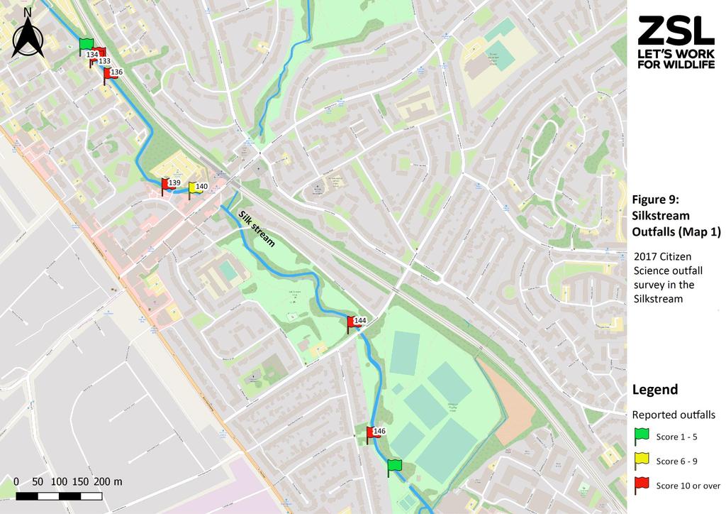
6 Conversion of outfall assessment to impact scores To assist with prioritisation of the outfalls, the Environment Agency provided a method of converting the assessment data to a numeric impact score for each outfall. These scores are shown in the right hand column in Table 1. Reporting Any outfall with an impact score 10, from the options in questions 8 and 9, were reported directly from the river to the Environment Agency s Incident Hotline and Thames Water. Both Thames Water and Environment Agency also received a copy of this report. Data Processing Outfall data were checked to remove double entries and those with an impact score of 1 were mapped using QGIS Desktop Results The volunteers photographed, located and assessed a total of 178 outfalls. Of this total 90 showed some signs of pollution and scored 0 and of these 47 were significantly polluting with a score 6. The locations of these outfalls are shown in Figures 2 to 11. The colour of the flags shown in the maps reflects the impact score for each outfall. The details of the outfalls with in impact score of 6 are given in Table 2. The numbers on the flags in Figures 2 to 11 references outfalls listed in Table 2. Outfalls 134 and 163 (Table 2) were reported from the river during the survey. The references for outfall 134 were EA and Thames Water and for 163, EA and Thames Water On 02/05/2017, details of the 29 outfalls that scored 10 were reported via the EA s Incident Hotline (reference number ). The full 2017 Dollis Brook and Silk Stream Outfall Safari dataset is available from ZSL. 5

7 6

8 7

9 8

10 9

11 10

12 11

13 12
14 13

15 14

16 15


17 Table 2 Details and photos of outfalls shown in figure 1 to 11- only outfalls with an impact score of greater 6 are included in the table Photo ID Location Details NGR Bank Side Outfall Score Photo 2 Upstream of the footbridge to Holden Road, access via Westbury Road TQ Left 8 7 Start of the footpath near the entrance to Folly Farm/Burtonhole Lane TQ Left Approximately 200m downstream of the entrance to Folly Farm TQ Left The allotments approximately 80m upstream of Dollis Rd TQ Left 8 25 Approximately 50m upstream of the tube viaduct near Dollis Rd TQ Left 8 27 Access via Michleham Down, in Woodsize Park TQ Right 8 29 Near the Woodside Park sports club access road also near Chanctonbury way TQ Right 8 33 At the Hendon Avenue Footbridge TQ Right m from Dollis Brook Walk, access via Alan Drive TQ Left m from Meadow Close or access from Barnet Lane (300 m along footpath) TQ Left 12 17


18 58 Just downstream of Barnett Lane TQ Right 8 68 Between Cherry Tree wood & the tube line- access via Brompton Grove, Mutton Brook TQ Left Rear of Belvedere Court, Lyttelton Road, Mutton Brook TQ Left Rear of Belvedere Court, Lyttelton Road, Mutton Brook TQ Right Northway Bridge, Mutton Brook TQ Right 8 79 Just downstream of Fallodon Way Road Bridge (A1) TQ Right Downstream of Brookland Rise Road Bridge, Mutton Brook TQ Right Dollis Valley Green Walk, near the A1- footpath access off Addison Way TQ Right 8 86 Dollis Valley Green Walk, Rear of a 38 Hurstwood Road- footpath access off Addison Way TQ Left Dollis Valley Green Walk, Rear of a 54 Hurstwood Road- footpath access off Addison Way TQ Left Downstream of the North Circular Road- access via Bridge Lane TQ Right Just downstream of Hendon Lane Weir- access via Riverside Gardens TQ Right 12 12


19 94 10 m downstream of Hendon Lane Weir- access via Riverside Gardens TQ Left Access via the footpath from Southbourne Crescent TQ Left m upstream of the Dollis Brook and Mutton Brook confluence- access via the footpath from Southbourne Crescent TQ Right Opposite 64 Totteridge Lane on the Dollis Brook TQ Left Behind approximately 25 Longland Drive- access via the Dollis Valley Greenwalk TQ Right Upstream of Tillingham Way- near 18 Lorian Close, N12 7DZ TQ Left Access via Fursby Rd - at the downstream end of the First Rd allotments- visible from the Dollis Valley Greenwalk TQ Left Just upstream of Dollis Road Bridge TQ Left Underneath Abercorn Road Bridge TQ Right m upstream of Mill Hill East Underground Line- access off the Dollis Road TQ Left Rosscoff, close TQ Right 20 13


 - access")

20 136 Rosscoff Close, Silk Stream - access is only from within the channel via Edgware Hospital TQ Right Barnfield Road car park - just upstream of bridge-edgware TQ Right m upstream of Watling Avenue TQ Right Silk Stream Park 10m upstream of Montrose avenue TQ Right Montrose Playing Fields at the foot bridge near Greenway Gardens entrance to the park TQ Right Near Marlow Court - access via inchannel only TQ Right At Colindeep Lane bridge TQ Right Colindeep Lane and Rushgrove Avenueoutfall is set back with a 5m polluted channel flowing into the Silk Stream TQ Right Rushgrove Avenue (near 188) - access in-channel only TQ Right Colin Crescent, off Colindeep Lane TQ Right Under Crossway Bridge, NW9 6RA TQ Right 12 14

.")

21 170 Downstream end of Scottwell Drive, Crossway - access is via in- channel TQ Right Upstream end of Hyde Estate Road TQ Right Behind the large Sainsburys on the A5 TQ Right 12 Discussion Some outfalls pollute intermittently and may not have been detected as a problem during the survey but this report represents an audit of how outfalls, within the surveyed areas of the Brent catchment, were behaving during the survey. In total there are 66km of river in the Brent Catchment, this Outfall Safari surveyed 37% of this length and recorded 29 seriously polluting outfalls (score of 10). This is 16% of all outfalls assessed. Thames Waters, Surface Water Outfall Programme team are working to remediate 42 Brent catchment outfalls during the 2015 to 2020 investment period (AMP 6). These data show there needs to be a scaling up of effort to properly stem the flow of pollution via outfalls into Brent Catchment rivers. Not all the outfalls assessed in the Outfall Safari are Thames Water s assets but many are and the Brent Catchment Partnership (BCP) request a response from Thames Water to the findings of this report. BCP has four priority themes for improving the ecological value of the rivers within the catchment, Theme 1 being to reduce pollution. The objectives in this theme are: By 2021, water quality in the Brent catchment has improved and has a moderate ability to support wildlife o o o o A moderate ability to support wildlife and means that: Phosphate concentrations are 0.25 mg/l or less Dissolved oxygen levels are 54% saturation or higher Levels of total ammonia are no higher than 1.1mg/l 15
22 By 2027, it will have a good ability to support wildlife o o o o A Good ability to support wildlife means that: Phosphate concentration are 0.12 mg/l or less Dissolved oxygen levels are 60% saturation or higher Levels of total ammonia are no higher than 0.6mg/l Removing polluting entering the river via outfalls will be a significant step towards achieving these objectives. This report outlines the findings of the third Outfall Safari conducted in Greater London. Outfall Safaris of the River Pinn and Ravensbourne are planned for Autumn 2017 in partnership with Thames 21. Once these are conducted, ZSL will work with members of the Catchment Partnerships in London to properly analyse Outfall Safari data and make recommendations about the numbers of outfalls that need to be remediated annually to effectively tackle the problem of pollution from outfalls degrading the ecological value of rivers in London. References Dunk, M.J., McMath, S.M., Arikans, J., A new management approach for the remediation of polluted surface water outfalls to improve river water quality. Water Environ. J. 22, Contact details Joe Pecorelli: Project Manager - Europe Conservation Programme joe.pecorelli@zsl.org 16
An audit of the surface water outfalls in the River Ingrebourne - Outfall Safari
 An audit of the surface water outfalls in the River Ingrebourne - Outfall Safari December 2017 UK & Europe Conservation Programme Zoological Society of London Regent's Park London, NW1 4RY marineandfreshwater@zsl.org
An audit of the surface water outfalls in the River Pinn - Outfall Safari
 An audit of the surface water outfalls in the River Pinn - Outfall Safari October 2017 UK & Europe Conservation Programme Zoological Society of London Regent's Park London, NW1 4RY marineandfreshwater@zsl.org
Report on the Hogsmill River Outfall Safari
 Report on the Hogsmill River Outfall Safari 24 th November 201 UK & Europe Conservation Programme Zoological Society of London Regent's Park London, NW1 4RY marineandfreshwater@zsl.org www.zsl.org/conservation/regions/uk-europe/london
Clearwater Photography UK
 1 Tackling Pollution in London s Rivers November 2017 Clearwater Photography UK 2 Within the Greater London Authority boundary there are 39 rivers, of which, so far, only one has been classified as achieving
Outfall Safari. An audit of the surface water outfalls in the urban parts of the Alfreton Brook and Oakerthorpe Brook Catchments, Derbyshire
 Outfall Safari An audit of the surface water outfalls in the urban parts of the Alfreton Brook and Oakerthorpe Brook Catchments, Derbyshire February 2018 Revision History Revision Ref / Date Issued Amendments
Tackling Pollution in Urban Rivers:
 1 Tackling Pollution in Urban Rivers: A Guide to Running an Outfall Safari January 2019 2 3 Prepared by Acknowledgements Supported by Contents 4 Background 4 Introduction 6 What are polluted surface water
Polluted Surface Water Outfalls -what s the problem?
 Polluted Surface Water Outfalls -what s the problem? Malcolm Dunk Senior Consultant (Wastewater Quality) - Thames Water Utilities and Julian Arikans Technical Specialist (Water Quality) - The Environment
The Duke s River: Revitalising the link between the River Crane and the River Thames
 The Duke s River: Revitalising the link between the River Crane and the River Thames The project The eastern section of the Duke of Northumberland s River runs for approximately four kilometres, from where
Brookside Walk Children's Play Area, London, NW4
 LOCATION: Brookside Walk Children's Play Area, London, NW4 REFERENCE: H/05584/13 Received: 26 November 2013 Accepted: 11 December 2013 WARD(S): Hendon Expiry: 05 February 2014 Final Revisions: APPLICANT:
Why we need the Counters Creek storm relief sewer
 Counters Creek storm relief sewer Why we need the Counters Creek storm relief sewer The problem The sewer network we operate today has been much improved and vastly extended over the years and remains
Andrea Griffiths BSc HONS Partnership Officer Medway Valley Countryside Partnership. Medway Valley Countryside Partnership
 Medway Valley Countryside Partnership Giant Hogweed and Invasive Non Native Plant Project Medway Catchment and River Cray 2013/2014 Report Andrea Griffiths BSc HONS Partnership Officer Medway Valley Countryside
Policy and Resources Committee 10 th October Green Infrastructure Supplementary Planning Document (SPD) Summary. Title
 Summary. Title") Policy and Resources Committee 10 th October 2017 Title Report of Wards Status Urgent Key Enclosures Officer Contact Details Green Infrastructure Supplementary Planning Document (SPD) Deputy Chief Executive
Policy and Resources Committee 10 th October 2017 Title Report of Wards Status Urgent Key Enclosures Officer Contact Details Green Infrastructure Supplementary Planning Document (SPD) Deputy Chief Executive
Case studies. B1.1 Lloyds Crossing, Portland (USA)
") B. Case Studies 57 B1 Case studies B1.1 Lloyds Crossing, Portland (USA) Lloyds Crossing in Portland is a brownfields redevelopment site in the central city area, with the aim of: Developing a conceptual
B. Case Studies 57 B1 Case studies B1.1 Lloyds Crossing, Portland (USA) Lloyds Crossing in Portland is a brownfields redevelopment site in the central city area, with the aim of: Developing a conceptual
Letcombe Brook Project Officer
 Letcombe Brook Project Officer Job Description Responsible to: Responsible for: Purpose of post: Key Committees: Chairman and Trustees of Letcombe Brook Project. Project volunteers and any relevant personnel
Photo 1: Upper Rock Creek Trash, east of Ogontz Ave. Map 1: Map of Upper Rock Creek with photos of conduit openings
 Philadelphia and Cheltenham Litter Polluting Upper Rock Creek Kelly O Day Litter from the Wadsworth shopping area, Cheltenham Avenue, Limekiln Pike, Ogontz Avenue and the 3 large Cheltenham shopping malls
Urban runoff in my neighborhood (Capitol Hill) is heavy with trash and other debris.
 is heavy with trash and other debris.") South Platte River Meeting Comments & s #1 I am a huge fan of river areas and would love the Platte and surrounding waterways to improve to allow habitat for wildlife and recreation opportunities for citizens.
South Platte River Meeting Comments & s #1 I am a huge fan of river areas and would love the Platte and surrounding waterways to improve to allow habitat for wildlife and recreation opportunities for citizens.
WADDON PONDS MANAGEMENT AND MAINTENANCE PLAN 2017
 WADDON PONDS MANAGEMENT AND MAINTENANCE PLAN 2017 BACKGROUND Waddon Ponds is a 3.09 hectare site situated within a mixed residential, retail and industrial area in London Borough of Croydon (LBC), approximately
EDC 016/004 Annex A. Framework Masterplan Stakeholder and public engagement
 Framework Masterplan Stakeholder and public engagement A summary of stakeholder feedback received in December 2015 1 Stage 1 Emerging findings This briefing note provides the emerging findings and key
Highlands Region Stormwater Management Program Guidance
 DRAFT Highlands Region Stormwater Management Program Guidance Release Date: January 2016 Abstract This guidance document provides an overview of the Highlands Stormwater Management Program. It is intended
Standard Operating Procedure: Outfall Inspections
 Standard Operating Procedure: Outfall Inspections Date: 12/21/2018* Version: 3 Review Frequency: Annual Reasons for Procedure The University of Virginia (UVA) has a permit to operate a Municipal Separate
Initial OPW Designation APSR AFRR IRR Co-ordinates Easting: Northing: Fluvial non-tidal Fluvial tidal Coastal
 Location: Athlone, Co. Westmeath (including townland in Roscommon) Unique ID: 260448 (from PFRA database) Initial OPW Designation APSR AFRR IRR Co-ordinates Easting: 205000 Northing: 239999 River / Catchment
Rudy Parish Neighbourhood Plan Steering Group Meeting 6/8/2018. Proposed Green Spaces (Continued from SG meeting of 2/7/18)
") Rudy Parish Neighbourhood Plan Steering Group Meeting 6/8/2018 Proposed Green Spaces (Continued from SG meeting of 2/7/18) NPPF: Green Space Designation The Local Green Space designation will not be appropriate
Rudy Parish Neighbourhood Plan Steering Group Meeting 6/8/2018 Proposed Green Spaces (Continued from SG meeting of 2/7/18) NPPF: Green Space Designation The Local Green Space designation will not be appropriate
Feasibility study for new foot/cycle bridge across the River Tillingham
 Feasibility study for new foot/cycle bridge across the River Tillingham 1. Why is a bridge needed? Currently all residents of Tilling Green and Valley Park can only get into Rye via the Ferry Road / Udimore
Welcome to our public exhibition
 About Our Scheme Welcome to our public exhibition This exhibition gives you the chance to view and comment upon our emerging proposals for a new residential development of 68 new homes on the site of the
Renfrew Close, London
 Renfrew Close, London SuDS used Rain gardens Shallow rainwater conveyance channel Shallow detention basin Conveyance channels Benefits 1. Location Effective reduction in flood risk. Creation of attractive,
Alma Road Rain Gardens, London
 Alma Road Rain Gardens, London SuDS used Rain gardens Permeable paving Tree planting Benefits 1. Location Reduction in flooding from intense rainfall. Reduced surface water pollution to receiving water
Parks and Open Spaces Our Strategy for Barnet
 Parks and Open Spaces Our Strategy for Barnet 2016-2026 2 Give us your views Draft Parks and Open Spaces Strategy for Barnet Full Summary Appendix to Consultation Document 2016-2026 Give us your views
Philadelphia Creek Trash Assessment (PCTA) Methodology Mill Run Creek Test Case
 Methodology Mill Run Creek Test Case") Philadelphia Creek Trash Assessment (PCTA) Methodology Mill Run Creek Test Case Mill Run Creek emerges from a covered creek in Philadelphia to an open creek in Cheltenham. The Creek has extensive trash
Philadelphia Creek Trash Assessment (PCTA) Methodology Mill Run Creek Test Case Mill Run Creek emerges from a covered creek in Philadelphia to an open creek in Cheltenham. The Creek has extensive trash
NORTH WEST LEEDS COUNTRY PARK AND GREEN GATEWAYS PROJECT. Country Parks Officer Douglas Louis
 NORTH WEST LEEDS COUNTRY PARK AND GREEN GATEWAYS PROJECT Country Parks Officer Douglas Louis Vision To Preserve, Improve and Promote Green Spaces and their Connectivity for People & Wildlife in North West
Christchurch City Council Civic Offices 53 Hereford Street Christchurch. Submission on: The Draft Annual Plan 2014/15
 City Council Civic Offices 53 Hereford Street Submission on: The Draft Annual Plan 2014/15 Response by: Avon-Ōtākaro Network 9 Stable Way Belfast The Avon-Ōtākaro Network [AvON], is a network of individuals
Priors Farm Estate SuDS Retrofitting Project, Cheltenham
 Priors Farm Estate SuDS Retrofitting Project, Cheltenham SuDS used Detention basins Bioretention Planters Rain Gardens Benefits Reduction of surface water flooding 1. Location Priors Farm Estate, Oakley,
Technical note. Option 3a (cyan route) Project: To: A428 Bus Enhancement Scheme. Rid Hollands, Colin Young
 Project: To: A428 Bus Enhancement Scheme. Rid Hollands, Colin Young") Project: A428 Bus Enhancement Scheme To: Rid Hollands, Colin Young Subject: Flood Risk Desktop study From: Liz Hillcoat, Charlotte Nunns Date: 26 Jan 2017 cc: Term Awarded Watercourse Main River Ordinary
Project: A428 Bus Enhancement Scheme To: Rid Hollands, Colin Young Subject: Flood Risk Desktop study From: Liz Hillcoat, Charlotte Nunns Date: 26 Jan 2017 cc: Term Awarded Watercourse Main River Ordinary
Tookany Creek Watershed Trash Pollution Update Photographic Trash Surveys Jan- Mar, 2013
 Tookany Creek Watershed Trash Pollution Update Photographic Trash Surveys Jan- Mar, 2013 Tookany Creek Surveys 1. Cedarbrook Plaza and Upper Rock Creek 2. Cheltenham Mall and Upper Rock Creek 3. Cedarbrook
St. Asaph Flood Risk Management Scheme Case Study KS2/3
 St. Asaph Flood Risk Management Scheme Case Study KS2/3 St. Asaph Awarded city status 2012, St Asaph is a small city in North Wales, situated in the Vale of Clwyd between Denbigh and the coastal resort
Unique ID: (from PFRA database) Location: Tralee, Co. Kerry. Stage 1: Desktop Review
 Location: Tralee, Co. Kerry. Stage 1: Desktop Review") Location: Tralee, Co. Kerry Unique ID: 230361 (from PFRA database) Initial OPW Designation APSR AFRR IRR Co-ordinates Easting: 82750 Northing: 114000 River / Catchment / Sub-catchment Lee River & Big River/
Location: Tralee, Co. Kerry Unique ID: 230361 (from PFRA database) Initial OPW Designation APSR AFRR IRR Co-ordinates Easting: 82750 Northing: 114000 River / Catchment / Sub-catchment Lee River & Big River/
Upper Dean Landscape Character Area: A1 Landscape Character Type: River Valley
 Upper Dean Landscape Character Area: A1 Landscape Character Type: River Valley Key characteristics A well wooded river valley landscape Strong human influence with urban development and sections of engineered
Taking forward the All London Green Grid
 Taking forward the All London Green Grid Foreword Earlier this year, the Mayor published the All London Green Grid Supplementary Planning Guidance to the London Plan which set the vision, and framework,
Just The Basics: Illicit Discharge. What does it mean to me?
 Just The Basics: Illicit Discharge What does it mean to me? What is an Illicit Discharge? An illicit discharge is the discharge of pollutants or non-storm water materials to storm water drainage systems
Heron Court Rain Garden, London
 Heron Court Rain Garden, London SuDS used Rain Gardens Benefits Increased infiltration of water reduced quantity of runoff and improved quality Increased amenity value, social cohesion and wellbeing of
Severn River Sub-Watershed: BMP 09-Retrofit
 Project ID: BMP_09 Total Treated Drainage Area: 4.57 acres Total Treated Impervious Area: 2.9 acres Total Water Quality Volume (WQv): ~10,300 cubic feet; 0.236 acre-foot Rainfall Depth Treated (Pe): 1
WA PARKS FOUNDATION SWAN CANNING RIVERPARK
 WA PARKS FOUNDATION SWAN CANNING RIVERPARK Photograph: Giant Egret Large - Matt Kleczkowski SWAN CANNING RIVERPARK - RIVER JOURNEYS PROJECT Bringing Parks to our doorstep With the pace and demands of modern
Thank you for your letter of 26 June regarding the Committee s scrutiny of building regulations in Scotland.
 Minister for Local Government and Housing Kevin Stewart MSP T: 0300 244 4000 E: scottish.ministers@gov.scot Bob Doris MSP Convener Local Government and Communities Committee The Scottish Parliament EDINBURGH
Design & Practical Application
 WHO European Healthy Cities Network Workshop and Masterclass: Healthy People and Healthy Places in the WHO European Region Design & Practical Application Etive Currie NHS Health Scotland & GCC Senior Planner
Municipal Action Teams
 Municipal Action Teams Debbie Mans NY/NJ Baykeeper (e) debbie@nynjbaykeeper.org Rosana Da Silva Rutgers Cooperative Extension Water Resources Program (e) rdasilva@envsc.rutgers.edu February 26, 2016 NY/NJ
Hollickwood Primary School, London
 Hollickwood Primary School, London SuDS used Bioretention bog garden Swales Detention areas Retention areas Benefits 1. Location Improvement of water quality. Reduction in local and wider flood risk. SuDS
An Open Spaces Strategy for Barnet
 An Open Spaces Strategy for Barnet 2016-2026 2 An Open Spaces Strategy for Barnet An Open Spaces Strategy for Barnet 3 Contents Executive summary 4 Why do we need an Open Spaces Strategy? 6 Policy Context
Key Environmental Issues in U.S. EPA Region 2 Panel 4 Water Issues
 Key Environmental Issues in U.S. EPA Region 2 Panel 4 Water Issues Angela Licata, Deputy Commissioner for Sustainability New York City Department of Environmental Protection May 29, 2014 Consumption Declining,
Olympic Park, London. SuDS used. 1. Location. 2. Description. Case study
 Olympic Park, London SuDS used Porous asphalt strips Wetlands Swales Filter strips Filter drains Balancing ponds Rainwater harvesting 1. Location Olympic Park, Stratford, East London, E20 2ST. 2. Description
AT THE HEART OF LAND & WATER MANAGEMENT ON TWEED. tweedforum.org
 AT THE HEART OF LAND & WATER MANAGEMENT ON TWEED Why do we exist? The Tweed is one of the region s greatest assets. It provides a focal point for our natural, built and cultural heritage and a multitude
PUBLIC REALM STRATEGY
 CONSULTATION DRAFT PUBLIC REALM STRATEGY Trenchard Street & Frogmore Street City Design Group Place Directorate Public Realm Strategy Trenchard Street & Frogmore Street Contents 1. Introduction 2. Understanding
Manor Ponds, Sheffield
 Manor Ponds, Sheffield SuDS used Ponds Basins Benefits 1. Location Substantial improvement in amenity and biodiversity value. Effective stormwater treatment. Engagement/educational opportunity for all
COMMUNITY GROWN FOOD IN WALES
 COMMUNITY GROWN FOOD IN WALES 2012 1 EXECUTIVE SUMMARY This executive summary provides an overview of research carried out by the WRO between July 2010 and December 2011 to investigate activities relating
MUNICIPAL SEPARATE STORM SEWER SYSTEM 2011 ANNUAL REPORT
 MUNICIPAL SEPARATE STORM SEWER SYSTEM 2011 ANNUAL REPORT Permit Number 85-03-0-04 March 2012 Prepared by Department of Environmental Health and Safety and Facilities Planning and Management 2809 Daley
URBAN FLOOD MANAGEMENT IN CYPRUS CASE STUDY IN NICOSIA URBAN AREA
 URBAN FLOOD MANAGEMENT IN CYPRUS CASE STUDY IN NICOSIA URBAN AREA Antonis D. Toumazis Partner, Dion Toumazis & Associates Visiting Lecturer, University of Cyprus Abstract Cyprus is experiencing negative
HS2 Environment. Protecting the environment
 HS2 Environment Protecting the environment Approach to mitigation EIA Regulations require an ES to include a description of the measures envisaged in order to avoid, reduce and, if possible, remedy significant
Welcome to our public exhibition
 Welcome to our public exhibition This public exhibition gives you the opportunity to view and comment upon our emerging plans for a new residential development at Oaklands College in St Albans. Our proposals
Victoria Street Pedestrian Bridge
 Township of Centre Wellington Victoria Street Pedestrian Bridge Class Environmental Assessment County of Wellington & Township of Centre Wellington Badley Bridge Replacement/Rehabilitation (County of Wellington),
Pittsfield Action Plan (West Branch of the Housatonic River)
") An initiative of the Massachusetts Executive Office of Energy and Environmental Affairs in partnership with the City of Pittsfield Pittsfield Action Plan (West Branch of the Housatonic River) The spring
An initiative of the Massachusetts Executive Office of Energy and Environmental Affairs in partnership with the City of Pittsfield Pittsfield Action Plan (West Branch of the Housatonic River) The spring
Ashbridges Bay Erosion and Sediment Control Project
 Ashbridges Bay Erosion and Sediment Control Project Project Brief Overview Toronto and Region Conservation Authority, in partnership with the City of Toronto, intends to carry out remedial erosion control
Ashland BRT Environmental Assessment: logos of CTA, CDOT, Chicago Department of Housing and Economic Development
 Ashland BRT Environmental Assessment: logos of CTA, CDOT, Chicago Department of Housing and Economic Development Overview The Chicago Transit Authority (CTA), in partnership with the Chicago Department
FELTHAM MASTERPLAN CONSULTATION MARCH 2017 RESPONSE BY FRIENDS OF THE RIVER CRANE ENVIRONMENT (FORCE)
") FELTHAM MASTERPLAN CONSULTATION MARCH 2017 RESPONSE BY FRIENDS OF THE RIVER CRANE ENVIRONMENT (FORCE) Friends of the River Crane Environment (FORCE) FORCE was set up in 2003 and is a west London charity,
FELTHAM MASTERPLAN CONSULTATION MARCH 2017 RESPONSE BY FRIENDS OF THE RIVER CRANE ENVIRONMENT (FORCE) Friends of the River Crane Environment (FORCE) FORCE was set up in 2003 and is a west London charity,
Rainwise. Sustainable Drainage Solutions. Working with communities to manage rainwater. Wuppertal Court, Jarrow
 Rainwise Sustainable Drainage Solutions Working with communities to manage rainwater Wuppertal Court, Jarrow Wuppertal Court is located near the centre of Jarrow and is approximately 1km south of the River
Green Infrastructure: Implementation at the Community Level
 Green Infrastructure: Implementation at the Community Level Debbie Mans NY/NJ Baykeeper Sandra Meola NY/NJ Baykeeper Pamela Daniels United Vailsburg Services Organization NY/NJ Baykeeper NY/NJ Baykeeper's
Greening streets, retrofit rain gardens, Nottingham
 Greening streets, retrofit rain gardens, Nottingham SuDS used Rain gardens Benefits Proven surface water capture and infiltration leading to reduced pressure on downstream sewer and watercourse. Increased
Archaeological Monitoring of Land at 29 Royal Pier Road, Gravesend, Kent
 Archaeological Monitoring of Land at 29 Royal Pier Road, Gravesend, Kent Site Code ROY/WB/15 Report for Dr Maxted Date of report 06/10/2015 SWAT ARCHAEOLOGY Swale and Thames Archaeological Survey Company
Neighbourhood Planning Local Green Spaces
 Neighbourhood Planning Local Green Spaces Introduction... 2 1. Why green space is important... 4 2. Neighbourhood plans and green space... 6 3. Evidence... 8 Statutory designations... 9 Green space audit...
Urban Green Space Management (Horticulture) FdSc Course outline
 FdSc Course outline") Urban Green Space Management (Horticulture) FdSc Course outline Module Outline Year 1 Module 1: Plant Development and Knowledge (20 credits) Develop applied knowledge and skills based on the principles
Urban Green Space Management (Horticulture) FdSc Course outline Module Outline Year 1 Module 1: Plant Development and Knowledge (20 credits) Develop applied knowledge and skills based on the principles
Public Consultation. Land at Monks Farm, North Grove. Welcome
 Welcome Welcome to our public exhibition for development on Land at Monks Farm, orth Grove. Gallagher Estates and Gleeson Strategic Land are preparing an outline planning application for new homes, open
Decent homes need decent spaces
 Encourage people to be more active by providing attractive, well-maintained open spaces. Walking, cycling and play can become part of everyday routines if people have easy access to an attractive network
Groby Pool and Bradgate Park. Circular walks around Leicestershire. Lin and John
 Groby Pool and Bradgate Park Bradgate House Lin and John A circular walk from Groby Pool via Anstey Village, Bradgate Park and Newtown Linford Village. Duration - 2 ½ to hours 3½ hours Distance - 9¼ kilometres
Slough International Freight Exchange Proposals, Colnbrook+
 Welcome Welcome to this exhibition, which is being held in connection with our proposals for a new freight exchange facility on land to the north of the A4. Please take this opportunity to look at the
Greater London. Greater London 6/42 (D.01.M001) TQ
 TQ") Authority 6/42 (D.01.M001) TQ 54207390 ST. JAME'S INVESTMENTS, LOWFIELD STREET AND MARKET STREET, DARTFORD Environmental Statement. Archaeology. Volume 9 of 10 AOC Archaeology Group Twickenham : AOC Archaeology
Authority 6/42 (D.01.M001) TQ 54207390 ST. JAME'S INVESTMENTS, LOWFIELD STREET AND MARKET STREET, DARTFORD Environmental Statement. Archaeology. Volume 9 of 10 AOC Archaeology Group Twickenham : AOC Archaeology
Fluvial non-tidal Fluvial tidal Coastal. PFRA database comments (in italics): OPW comments Minor flooding of residents on golf links road
: OPW comments Minor flooding of residents on golf links road") Location: Charleville, Co. Cork Unique ID: 240375 (from PFRA database) Initial OPW Designation APSR AFRR IRR Co-ordinates Easting: 152250 Northing: 122500 River / Catchment / Sub-catchment Glen River /
Location: Charleville, Co. Cork Unique ID: 240375 (from PFRA database) Initial OPW Designation APSR AFRR IRR Co-ordinates Easting: 152250 Northing: 122500 River / Catchment / Sub-catchment Glen River /
Sorted citizen input comments in review of Blount County plans July, August, and September 2007
 Sorted citizen input comments in review of Blount County plans July, August, and September 2007 The following presents sorted citizen input comments from three sessions held in July, August and September
Preparing for MS4 in the Neponset Valley. December 4, 2015
 Preparing for MS4 in the Neponset Valley December 4, 2015 2013 Data Samples represent average of 6 sampling events 2 out of 6 sampling events took place following rain 2014 Data Samples represent average
PUBLIC NOTIFICATION PLAN
 VILLAGE OF LA GRANGE, ILLINOIS NPDES PERMIT NO. ILM580009 COMBINED SEWER OVERFLOW PUBLIC NOTIFICATION PLAN NATIONAL POLLUTANT DISCHARGE ELIMINATION SYSTEM PROGRAM ILLINOIS ENVIRONMENTAL PROTECTION AGENCY
CHAPTER 8 ISSUES, CONCERNS, CONSTRAINTS AND OPPORTUNITIES
 CHAPTER 8 ISSUES, CONCERNS, CONSTRAINTS AND OPPORTUNITIES Introduction This River Conservation Plan was developed during a time of tremendous activity and effort in planning the transformation of the Delaware
Town of Vershire Road Erosion Inventory Report
 Town of Vershire Road Erosion Inventory Report Taylor Valley Road. Photo taken by TRORC staff. Prepared by: 128 King Farm Road Woodstock, VT 05091 Inventory and report funded by the Vermont Agency of Transportation
CTB3300WCx Introduction to Water and Climate
 CTB3300WCx Introduction to Water and Climate IN4 Urban Engineering Marie-Claire ten Veldhuis Welcome to urban engineering. My name is Marie Claire ten Veldhuis, and I work as an assistant professor for
Landscape values, people and change
 Landscape values, people and change Chris Bolton, Principal Specialist, Landscape Europarc Conference, Killarney 1 st October 2014 Topics ELC, CBD, Ecosystem services - Integration Natural and Social science
San Francisco Bay Pilot: Sausal Creek Community Leader Charrette May 11, 2016 Marcus Griswold
 San Francisco Bay Pilot: Sausal Creek Community Leader Charrette May 11, 2016 Marcus Griswold 1 Overview Project Overview Watershed Context Assets and Challenges Opportunities Green Streets Creek Access
When planning stormwater management facilities, the following principles shall be applied where possible.
 2.0 Principles When planning stormwater management facilities, the following principles shall be applied where possible. 2.0.1 Drainage is a regional phenomenon that does not respect the boundaries between
Unique ID: (from PFRA database) Location: Birr, Co. Offaly. Stage 1: Desktop Review
 Location: Birr, Co. Offaly. Stage 1: Desktop Review") Location: Birr, Co. Offaly Unique ID: 250410 (from PFRA database) Initial OPW Designation APSR AFRR IRR Co-ordinates Easting: 206,007 Northing: 204,990 River / Catchment / Sub-catchment Camcor River /
Location: Birr, Co. Offaly Unique ID: 250410 (from PFRA database) Initial OPW Designation APSR AFRR IRR Co-ordinates Easting: 206,007 Northing: 204,990 River / Catchment / Sub-catchment Camcor River /
Retrofitting SuDS. Virginia Stovin. Department of Civil and Structural Engineering Pennine Water Group University of Sheffield.
 Retrofitting SuDS Virginia Stovin Department of Civil and Structural Engineering Pennine Water Group University of Sheffield Outline Urban stormwater management Conventional approach, problems and costs
The Mystic River Greenway
 The Mystic River Greenway City of Medford November 30, 2006 MIT Department of Urban Studies and Planning The Mystic River Greenway A greenway is a regional network that connects: Open Space Visibility,
WILLIAM STREET STORM SEWER OUTFALL. PUBLIC INFORMATION CENTRE March 23, 2017
 WILLIAM STREET STORM SEWER OUTFALL Municipal Class Environmental Assessment PUBLIC INFORMATION CENTRE March 23, 2017 ACCESSIBILITY Under the Accessibility Standards 2015 for Customer Service Regulation
BlueHealth Environmental Assessment Tool (BEAT):
:") BlueHealth Environmental Assessment Tool (BEAT): Development and validation of a direct-observation audit tool for planning, design, management and post-occupancy evaluation of urban blue spaces. Himansu
BlueHealth Environmental Assessment Tool (BEAT): Development and validation of a direct-observation audit tool for planning, design, management and post-occupancy evaluation of urban blue spaces. Himansu
River Thames Scheme. Jenny Marshall-Evans Environmental Scientist. Handing over design to the public did it make a difference?
 River Thames Scheme Handing over design to the public did it make a difference? 24 April 2018 Jenny Marshall-Evans Environmental Scientist 1 1 Agenda Introduction RTS Vision Deliberative approach Enhancement
SH1 - Causeway, Auckland, 2014 (Source: NZ Transport Agency)
") SH1 - Causeway, Auckland, 2014 (Source: NZ Transport Agency) Coastal effects assessment guide Environmental and social responsibility policy State highway environmental plan Transport Agency statement
SH1 - Causeway, Auckland, 2014 (Source: NZ Transport Agency) Coastal effects assessment guide Environmental and social responsibility policy State highway environmental plan Transport Agency statement
Whole Kids Foundation Extended Learning Garden Grant Application - USA In Partnership with FoodCorps
 Whole Kids Foundation Extended Learning Garden Grant Application - USA In Partnership with FoodCorps *All information is collected online, this is a copy of the questions asked. This is an opportunity
Sports Grounds Directorate of Estates & Facilities - Document No. HS33 V2.1 Dated December 2014
 Contractor Site Induction Sports Grounds Directorate of Estates & Facilities - Document No. HS33 V2.1 Dated December 2014 About King s College London King s College London is an international Higher Education
UK Government perspective on natural capital
 UK Government perspective on natural capital Conference on Natural and Cultural Capital: the Future of Europe Botanical Garden of Rome, Italy. 24 November 2014 Shirley Trundle, Director, Department for
SOUTHERN GRAMPIANS WETLANDS INFORMATION DAY Sunday 23 rd November 2014
 SOUTHERN GRAMPIANS WETLANDS INFORMATION DAY Sunday 23 rd November 2014 Progress of wetland restoration trials at Walker, Gooseneck and Brady Swamps Mark Bachmann, Nature Glenelg Trust (NGT) The Walker,
Cambrian North Basin, Llanelli
 Cambrian North Basin, Llanelli SuDS used Detention Basin Benefits Reducing combined sewer overflow pollution events. Biodiversity and habitat creation. Amenity value through benches and linking cycle paths.
INTRODUCTION. Land south of Bishopswood Lane, Tadley
 0 INTRODUCTION THE SITE Introduction Gladman Developments Ltd. has successfully invested in communities throughout the UK over the past 0 years, developing high quality and sustainable residential, commercial
Hartest river corridor survey
 Hartest river corridor survey Project no. Report Date 56/15 Final 21st September 2015 Prepared by Penny Hemphill BSc. Hons Checked by Simone Bullion BSc. Hons, PhD., MCIEEM SWT Trading Ltd Suffolk Wildlife
West London Dyke, April 1947 Flood. Forks of the Thames, July 2000 Flood. Source: UTRCA
 This Public Information Centre is the 1 st of 2. Its purpose is to inform the public and to receive input with regards to the West London Dyke Master Repair Plan. The following panels describe the history,
Environment Agency Flood Risk Map for the Village of Bridge
 Environment Agency Flood Risk Map for the Village of Bridge December 2016 21 Objective F. Conserving and Enhancing the Natural Environment The National Planning Policy Framework states that the planning
CITY OF LONDON COVES ESA CONSERVATION MASTER PLAN COMMUNITY WORKSHOP #1
 CITY OF LONDON COVES ESA CONSERVATION MASTER PLAN COMMUNITY WORKSHOP #1 January 28 th 2014 Welcome! Purpose Reintroduce the Coves Conservation Master Plan (CMP) process; Provide an overview of Phase 1
BE WATER WISE. Managing Your Onlot Stormwater. Sept. 23, 2006 Watershed Weekend
 BE WATER WISE Managing Your Onlot Stormwater Sept. 23, 2006 Watershed Weekend 2006 1 All water resources are interrelated through the Hydrologic Cycle Sept. 23, 2006 Watershed Weekend 2006 2 What is Storm