Report on the Hogsmill River Outfall Safari
|
|
|
- Maximilian Daniels
- 5 years ago
- Views:
Transcription


1 Report on the Hogsmill River Outfall Safari 24 th November 201 UK & Europe Conservation Programme Zoological Society of London Regent's Park London, NW1 4RY s-rivers
2 Acknowledgements This project, funded by the Rivers Wetlands and Community Days Fund and The Postcode Local Trust, has been delivered on behalf of the Hogsmill Catchment Partnership with the support of Kingston Biodiversity Network, Kingston University, The Lower Mole Project, The Environment Agency (EA) and the South East Rivers Trust. It would not have been possible without the help of all the dedicated volunteers who collected the data. Special thanks go to Bill Millard and Peter Short. Introduction Misconnected waste water pipework, cross connected sewers and combined sewer overflows are a chronic source of pollution in urban rivers. An estimated 3% of properties in greater London are misconnected (Dunk et al., 2008) sending pollution, via outfalls, into the nearest watercourse. At the moment there is no systematic surveying of outfalls in rivers to identify sources of pollution and to notify the relevant authorities. The Outfall Safari (OSaf) is a survey method devised to address this reporting and evidence gathering gap. It was devised by the Citizen Crane project steering group which consists of staff from Thames Water, The Environment Agency, Friends of River Crane Environment, Frog Environmental and the Zoological Society of London (ZSL). It was first used on the River Crane in 201. Aims The aims of the Hogsmill OSaf were to: record and map the dry weather condition behaviour of surface water outfalls across the Hogsmill Catchment geolocate and photograph sources of pollution in the Hogsmill River and to report these to the EA and Thames Water recruit more volunteers and to further engage existing volunteers in the work of the Hogsmill Catchment Partnership. build evidence on the scale of the problem of polluted surface water outfalls in the London region 1
3 Method The survey of outfalls was conducted between October 1 st and November 3 rd 201. Twenty six people took part in the OSaf, comprising 24 volunteers and one member of staff from each of the Environment Agency and ZSL. Volunteers were trained during two separate training events, covering the following elements of activity: an overview of water quality issues in the Hogsmill catchment information on outfalls and how they become polluted instruction on how to assess each outfall using the project App and how to upload information to the database a health & safety briefing and signing of the risk assessment During the training, groups of volunteers were assigned lengths of river to survey. Further coordination of survey dates and reaches was conducted by the volunteer group on a closed Facebook group set up specifically for the Osaf. Groups of volunteers were free to conduct the survey of their reach when convenient to themselves, within the survey period, provided there had been no rain for 48 hours prior to survey. A period of 48 hours of no rain is required before any survey work since rainfall and high surface water flows can obscure the negative impacts of outfalls by washing away sewage fungus, discoloured sediments and rag. The majority of the survey work (19.0km) was conducted from the riverside path (see Figure 1a), with the occasional need to enter the river to properly assess and photograph an outfall. The risk assessment for riverside outfall surveying highlighted the need to assess conditions in the river before entering it and stressed that volunteers should only enter the river channel if the level was lower than Wellington boot depth (c.35cm). During the training volunteers were also shown images of Giant Hogweed (Heracleum mantegazzianum). It was essential that volunteers could identify Hogweed before undertaking any survey work as it is a relatively common plant along the banks of rivers in London and can burn and blister skin if touched. In some reaches of the river, where it flows through private land or is inaccessible from the banks, the survey had to be conducted in-channel. More stringent health and safety rules applied to in-channel surveys all of which were led by ZSL staff. Waders, stabilising poles and life jackets were used by in-channel survey teams (see Figure 1b). The local knowledge 2
 volunteers took a printed handout,")

4 of volunteers was very helpful in ensuring that all tributaries in the catchment were located. Approximately.5 km of the river were surveyed from within the channel bringing the total length of river surveyed to 25.5 km. In addition to personal protective equipment (PPE) volunteers took a printed handout, designed to help with ranking the impacts of each outfall, and a smart phone or tablet loaded with a specially created data entry App. The majority of the river and its tributaries were surveyed but small sections could not be accessed. These included: culverted sections private land, such as schools, to which we could not gain access some heavily overgrown stretches at the top of the tributaries a b Figure 1- Photos of volunteers surveys from, a, the riverbank and, b, with the EA in-channel The App For ease of data collection from the river, the volunteers used an app created in EpicollectPlus (plus.epicollect.net). Created by researchers at Imperial College, Epicollect is free and openly available. Once a project is set up in Epicollect it provides an app for remote data collection and upload, usable on GPS enabled smart phones, and a web portal to access and download the data. The outfall assessment form created in the app consisted of eleven questions for volunteers to fill in at each outfall. The questions are taken directly from the form that Thames Water use for assessing the impact of outfalls and are shown in Table 1. 3
5 Table 1 Questions used in the Epicollect App to assess each outfall and their corresponding Impact Score Question Options EA score 1. Volunteer name 2. Date of Survey 3. GPS location 4. Photo of the outfall 5. Catchment Location. Description of the nearest landmark 7. How many other outfalls can be seen from this location 8. Which bank is the outfall on (when looking downstream) 9. Ranking of the flow coming out of the outfall a. No Flow b. Trickle c. Low Flow d. Moderate Flow e. High Flow 10. Ranking of the visual impact of the outfall 11. Ranking of the aesthetics of the outfall a. No visible effect 0 b. Within 2m of outfall 2 c. Impact 2 to 10m 4 d. Impact 10 to 30m e. Impact greater than 30m 10 a. No odour or visible aesthetics 0 b. Faint smell, slight discolouration 2 c. Mild smell, mild discolouration, small coverage of sewage fungus d. Strong smell, strong discolouration, large coverage of sewage fungus and/ or litter e. Gross smell, gross sewage
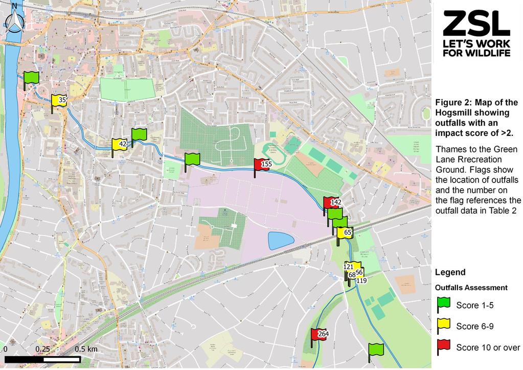
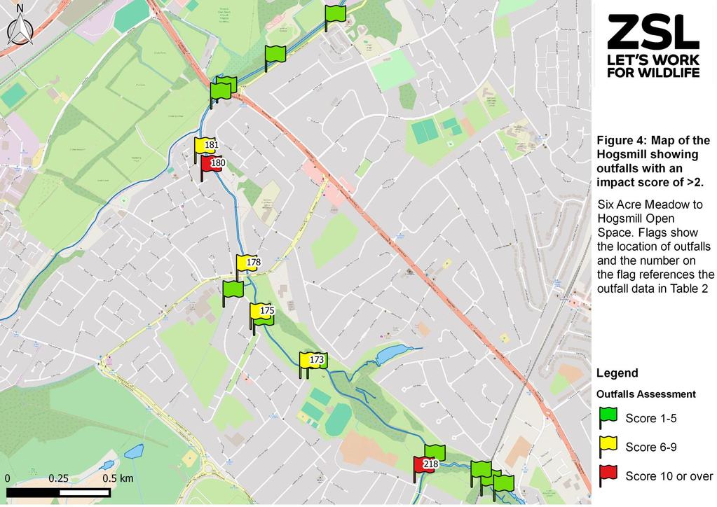
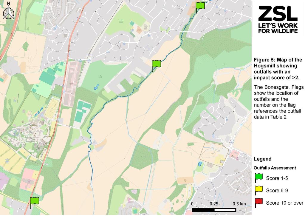
6 Conversion of outfall assessment to impact scores In order to assist with prioritisation of the outfalls, the EA provided a method of converting the assessment data to a numeric impact score for each outfall. These scores are shown on the right hand column in Table 1. Any outfall with an impact score of 8 or more, from the options in questions 10 and 11, were reported to the EA s National Reporting System (NRS). Data Processing Outfall data were checked to remove double entries and those with an impact score of two or greater were mapped using QGIS Desktop Results The volunteers photographed, located and assessed a total of 288 outfalls. Of this total 7 showed some signs of pollution and scored 0. The locations of these outfalls are shown in Figures 2 to. The colour of the flags shown in the maps reflects the impact score for each outfall. The details of the outfalls with in impact score of are given in Table 2. The numbers on the flags in Figures 2 to references outfalls listed in Table 2. The full 201 Hogsmill OSaf dataset is available from ZSL. 5
7
8 7
9 8
10 9

11 10


12 Table 2 Details and photos of outfalls shown in figure 1 to 5 - only outfalls with an impact score of greater than or equal to are included Photo ID NGR Location details side Assessment Score Photo 2 TQ Riverside Cottage, Old Malden Lane, Worcester Park 7 TQ sheephouse Way, Old Malden 10 8 TQ Knollemead, Tolworth 10 9 TQ Southwood Drive, Tolworth 10 TQ m upstream of A3 Malden Way S Bridge, New Malden 8 35 TQ St. James s Road, Kingston 11


13 42 TQ Knights Park Campus, Kingston 5 TQ Railway Bridge near Surbiton Hill Park, Berrylands 8 TQ South from Railway Bridge near Surbiton Hill Park, Berrylands 8 71 TQ Elmbridge Avenue, Tolworth TQ Tolworth Rise N Tolworth Rise N, Tolworth TQ Green Lane Footbridge, New Malden TQ m downstream of Green Lane Footbridge, Berrylands 12


14 142 TQ Near Barker Close, New Malden TQ Near Barker Close, New Malden TQ Cotterill Road East, Surbiton TQ m upstream of River Club Bridge, Old Malden Lane, Worcester Park TQ m from bridge at Ewell court100m downstream of Footbridge near Ewell Court, Ewell TQ m downstream of Footbridge from Alway Avenue, Ewell 8 13


15 178 TQ m downstream of Ruxley Lane Bridge, Ewell 180 TQ Flats on water sedge estate, near Rowden Road TQ Near Colne Ct Flats on Watersedge Estate, Ewell 218 TQ Footbridge near end of Green Lanes, Ewell TQ Holly Moor Lane, Ewell 228 TQ Gibraltar Crescent, Epsom 229 TQ Thames Water storm tank overflow opposite Blenheim School on Longmead Road, Epsom 8 14


16 232 TQ Just downstream of Gibraltar Crescent bridge near The King's Church, Epsom bank 23 TQ Roy Richmond Way, Epsom TQ Blenheim School, Roy Richmond Way, Epsom 8 24 TQ Near Scout Hut, behind Raeburn Avenue, Tolworth TQ Under Raeburn Avenue Bridge, Tolworth TQ Alexandra Recreation Ground, King Charles Road, Tolworth TQ King Charles Road - bridge - upstream - 3 or 5 here Alexander Recreational Ground, King Charles Road, Tolworth 8 15

17 Discussion Finding outfalls was not always easy, especially where there was thick vegetation reaching right down to the water s edge. The fact that volunteers, familiar with the river, found outfalls that they had not noticed before suggests the majority of outfalls were identified in the survey area. Nonetheless there could be some hidden outfalls that were missed. Volunteers were trained in assessing the impact of outfalls but there are elements of subjectivity in the assessment that may lead to inconsistencies in the way the outfalls are assessed. It is recommended that the data in this report is taken as a guide and that Thames Water reassess the outfalls listed in Table 2 before prioritising work within the catchment. Some outfalls were given low scores during the Safari but volunteers who have been monitoring them since 2015 with the South East Rivers Trust know that they are at least intermittently causing more serious problems than their impact scores suggest. Two in particular are shown in Figure 7 below. a b Figure 7- Photos of outfalls that were given a low impact score on the OSaf but are known by local residents to be discharging pollutants, a, at the A240 Bridge and, b, Cox Lane As well as outfalls, volunteers found a large number of small pipes, mostly along stretches in concrete channels, which appeared to be for surface water drainage. In accordance with instructions during training these were generally not recorded, but in a few cases where there was, for example, evidence of dry weather flow or possible pollution or where the appearance/location seemed unusual these were recorded. These are included in the database as a source for possible further examination. 1
18 Other issues reported during the OSaf A cracked sewer pipe at the point that it passes over The Green Lanes Stream, near Blenheim Road (TQ ). This was called in to Thames Water (reference ). Illegal fishing gear observed near River Club Bridge, Old Malden Lane, Worcester Park (TQ ). This was reported to the EA. Pollution from a portable toilet turned the river blue during a section of the OSaf in Ewell. This incident was reported to the EA. References Dunk, M.J., McMath, S.M., Arikans, J., A new management approach for the remediation of polluted surface water outfalls to improve river water quality. Water Environ. J. 22, Contact details Joe Pecorelli Project Manager - Europe Conservation Programme joe.pecorelli@zsl.org 17
An audit of the surface water outfalls in the River Ingrebourne - Outfall Safari
 An audit of the surface water outfalls in the River Ingrebourne - Outfall Safari December 2017 UK & Europe Conservation Programme Zoological Society of London Regent's Park London, NW1 4RY marineandfreshwater@zsl.org
An audit of the surface water outfalls in the River Pinn - Outfall Safari
 An audit of the surface water outfalls in the River Pinn - Outfall Safari October 2017 UK & Europe Conservation Programme Zoological Society of London Regent's Park London, NW1 4RY marineandfreshwater@zsl.org
An audit of the surface water outfalls in parts of the River Brent Catchment - Outfall Safari
 An audit of the surface water outfalls in parts of the River Brent Catchment - Outfall Safari April 2017 UK & Europe Conservation Programme Zoological Society of London Regent's Park London, NW1 4RY marineandfreshwater@zsl.org
Outfall Safari. An audit of the surface water outfalls in the urban parts of the Alfreton Brook and Oakerthorpe Brook Catchments, Derbyshire
 Outfall Safari An audit of the surface water outfalls in the urban parts of the Alfreton Brook and Oakerthorpe Brook Catchments, Derbyshire February 2018 Revision History Revision Ref / Date Issued Amendments
Tackling Pollution in Urban Rivers:
 1 Tackling Pollution in Urban Rivers: A Guide to Running an Outfall Safari January 2019 2 3 Prepared by Acknowledgements Supported by Contents 4 Background 4 Introduction 6 What are polluted surface water
Clearwater Photography UK
 1 Tackling Pollution in London s Rivers November 2017 Clearwater Photography UK 2 Within the Greater London Authority boundary there are 39 rivers, of which, so far, only one has been classified as achieving
Polluted Surface Water Outfalls -what s the problem?
 Polluted Surface Water Outfalls -what s the problem? Malcolm Dunk Senior Consultant (Wastewater Quality) - Thames Water Utilities and Julian Arikans Technical Specialist (Water Quality) - The Environment
Philadelphia Creek Trash Assessment (PCTA) Methodology Mill Run Creek Test Case
 Methodology Mill Run Creek Test Case") Philadelphia Creek Trash Assessment (PCTA) Methodology Mill Run Creek Test Case Mill Run Creek emerges from a covered creek in Philadelphia to an open creek in Cheltenham. The Creek has extensive trash
Philadelphia Creek Trash Assessment (PCTA) Methodology Mill Run Creek Test Case Mill Run Creek emerges from a covered creek in Philadelphia to an open creek in Cheltenham. The Creek has extensive trash
Manor Ponds, Sheffield
 Manor Ponds, Sheffield SuDS used Ponds Basins Benefits 1. Location Substantial improvement in amenity and biodiversity value. Effective stormwater treatment. Engagement/educational opportunity for all
Why we need the Counters Creek storm relief sewer
 Counters Creek storm relief sewer Why we need the Counters Creek storm relief sewer The problem The sewer network we operate today has been much improved and vastly extended over the years and remains
The Duke s River: Revitalising the link between the River Crane and the River Thames
 The Duke s River: Revitalising the link between the River Crane and the River Thames The project The eastern section of the Duke of Northumberland s River runs for approximately four kilometres, from where
Alma Road Rain Gardens, London
 Alma Road Rain Gardens, London SuDS used Rain gardens Permeable paving Tree planting Benefits 1. Location Reduction in flooding from intense rainfall. Reduced surface water pollution to receiving water
Photo 1: Upper Rock Creek Trash, east of Ogontz Ave. Map 1: Map of Upper Rock Creek with photos of conduit openings
 Philadelphia and Cheltenham Litter Polluting Upper Rock Creek Kelly O Day Litter from the Wadsworth shopping area, Cheltenham Avenue, Limekiln Pike, Ogontz Avenue and the 3 large Cheltenham shopping malls
Highlands Region Stormwater Management Program Guidance
 DRAFT Highlands Region Stormwater Management Program Guidance Release Date: January 2016 Abstract This guidance document provides an overview of the Highlands Stormwater Management Program. It is intended
Just The Basics: Illicit Discharge. What does it mean to me?
 Just The Basics: Illicit Discharge What does it mean to me? What is an Illicit Discharge? An illicit discharge is the discharge of pollutants or non-storm water materials to storm water drainage systems
Sports Grounds Directorate of Estates & Facilities - Document No. HS33 V2.1 Dated December 2014
 Contractor Site Induction Sports Grounds Directorate of Estates & Facilities - Document No. HS33 V2.1 Dated December 2014 About King s College London King s College London is an international Higher Education
Andrea Griffiths BSc HONS Partnership Officer Medway Valley Countryside Partnership. Medway Valley Countryside Partnership
 Medway Valley Countryside Partnership Giant Hogweed and Invasive Non Native Plant Project Medway Catchment and River Cray 2013/2014 Report Andrea Griffiths BSc HONS Partnership Officer Medway Valley Countryside
Initial OPW Designation APSR AFRR IRR Co-ordinates Easting: Northing: Fluvial non-tidal Fluvial tidal Coastal
 Location: Athlone, Co. Westmeath (including townland in Roscommon) Unique ID: 260448 (from PFRA database) Initial OPW Designation APSR AFRR IRR Co-ordinates Easting: 205000 Northing: 239999 River / Catchment
Tookany Creek Watershed Trash Pollution Update Photographic Trash Surveys Jan- Mar, 2013
 Tookany Creek Watershed Trash Pollution Update Photographic Trash Surveys Jan- Mar, 2013 Tookany Creek Surveys 1. Cedarbrook Plaza and Upper Rock Creek 2. Cheltenham Mall and Upper Rock Creek 3. Cedarbrook
TOPS K-8. Teacher Guide. CONTENTS Stormwater in the Schoolyard Lesson 3
 CONTENTS Stormwater in the Schoolyard Lesson 3 Local Stormwater Systems Lesson 5 Stormwater in Our Community Lesson 6 TOPS K-8 Teacher Guide How to Use This Guide This guide supports the Community Waters
City of Petersburg, VA Stormwater Utility Frequently Asked Questions
 Q. What is stormwater runoff? A. Stormwater runoff is the water that flows off roofs, driveways, parking lots, streets and other hard surfaces during rain storms. Stormwater runoff is also the rain that
MUNICIPAL SEPARATE STORM SEWER SYSTEM 2011 ANNUAL REPORT
 MUNICIPAL SEPARATE STORM SEWER SYSTEM 2011 ANNUAL REPORT Permit Number 85-03-0-04 March 2012 Prepared by Department of Environmental Health and Safety and Facilities Planning and Management 2809 Daley
Standard Operating Procedure: Outfall Inspections
 Standard Operating Procedure: Outfall Inspections Date: 12/21/2018* Version: 3 Review Frequency: Annual Reasons for Procedure The University of Virginia (UVA) has a permit to operate a Municipal Separate
Severn River Sub-Watershed: BMP 09-Retrofit
 Project ID: BMP_09 Total Treated Drainage Area: 4.57 acres Total Treated Impervious Area: 2.9 acres Total Water Quality Volume (WQv): ~10,300 cubic feet; 0.236 acre-foot Rainfall Depth Treated (Pe): 1
SPANISH TOWN, ST. CATHERINE JAMAICA
 SPANISH TOWN, ST. CATHERINE JAMAICA This presentation is aimed at emphasizing the importance of an effective community flood alert component of Community Flood Warning Systems (CFWS) in vulnerable communities
Renfrew Close, London
 Renfrew Close, London SuDS used Rain gardens Shallow rainwater conveyance channel Shallow detention basin Conveyance channels Benefits 1. Location Effective reduction in flood risk. Creation of attractive,
Pedestrian and Cycle Bridge Feasibility Study Report Summary
 Pedestrian and Cycle Bridge Feasibility Study Report Summary For London Borough of Richmond July 2018 OBJECTIVES The primary objective of introducing a new bridge across the Thames in Richmond is to improve
Swatara Township Stormwater Program. 1. There are no storm sewers on or near my property. Why should I pay a fee?
 1. There are no storm sewers on or near my property. Why should I pay a fee? All properties produce stormwater runoff that must be managed by the Township. Even if your property has never flooded and there
Priors Farm Estate SuDS Retrofitting Project, Cheltenham
 Priors Farm Estate SuDS Retrofitting Project, Cheltenham SuDS used Detention basins Bioretention Planters Rain Gardens Benefits Reduction of surface water flooding 1. Location Priors Farm Estate, Oakley,
Letcombe Brook Project Officer
 Letcombe Brook Project Officer Job Description Responsible to: Responsible for: Purpose of post: Key Committees: Chairman and Trustees of Letcombe Brook Project. Project volunteers and any relevant personnel
St. Asaph Flood Risk Management Scheme Case Study KS2/3
 St. Asaph Flood Risk Management Scheme Case Study KS2/3 St. Asaph Awarded city status 2012, St Asaph is a small city in North Wales, situated in the Vale of Clwyd between Denbigh and the coastal resort
Town of Vershire Road Erosion Inventory Report
 Town of Vershire Road Erosion Inventory Report Taylor Valley Road. Photo taken by TRORC staff. Prepared by: 128 King Farm Road Woodstock, VT 05091 Inventory and report funded by the Vermont Agency of Transportation
THE CITY OF DELAWARE, OHIO ILLICIT DISCHARGE DETECTION AND ELIMINATION PLAN
 THE CITY OF DELAWARE, OHIO ILLICIT DISCHARGE DETECTION AND ELIMINATION PLAN OCTOBER 2014 Table of Contents Section 1.0 Overview/Background... 1 Section 2.0 - General Permit Information... 2 Section 3.0
Environmental Statement Review for Infrastructure
 Environmental Statement Review for Infrastructure Temple s added value Temple is one of the UK s leading independent infrastructure and property consultancies, specialising in environment, planning and
Waterways and wetlands investigations
 A4! Waterways and wetlands investigations Wader Beach Project: Gross Pollutant Traps Most of the litter at Wader Beach is sourced from uncontained debris in the Bay being deposited on the beach through
Christchurch City Council Civic Offices 53 Hereford Street Christchurch. Submission on: The Draft Annual Plan 2014/15
 City Council Civic Offices 53 Hereford Street Submission on: The Draft Annual Plan 2014/15 Response by: Avon-Ōtākaro Network 9 Stable Way Belfast The Avon-Ōtākaro Network [AvON], is a network of individuals
Unique ID: (from PFRA database) Location: Tralee, Co. Kerry. Stage 1: Desktop Review
 Location: Tralee, Co. Kerry. Stage 1: Desktop Review") Location: Tralee, Co. Kerry Unique ID: 230361 (from PFRA database) Initial OPW Designation APSR AFRR IRR Co-ordinates Easting: 82750 Northing: 114000 River / Catchment / Sub-catchment Lee River & Big River/
Location: Tralee, Co. Kerry Unique ID: 230361 (from PFRA database) Initial OPW Designation APSR AFRR IRR Co-ordinates Easting: 82750 Northing: 114000 River / Catchment / Sub-catchment Lee River & Big River/
Urban runoff in my neighborhood (Capitol Hill) is heavy with trash and other debris.
 is heavy with trash and other debris.") South Platte River Meeting Comments & s #1 I am a huge fan of river areas and would love the Platte and surrounding waterways to improve to allow habitat for wildlife and recreation opportunities for citizens.
South Platte River Meeting Comments & s #1 I am a huge fan of river areas and would love the Platte and surrounding waterways to improve to allow habitat for wildlife and recreation opportunities for citizens.
Rainwise. Sustainable Drainage Solutions. Working with communities to manage rainwater. Wuppertal Court, Jarrow
 Rainwise Sustainable Drainage Solutions Working with communities to manage rainwater Wuppertal Court, Jarrow Wuppertal Court is located near the centre of Jarrow and is approximately 1km south of the River
FELTHAM MASTERPLAN CONSULTATION MARCH 2017 RESPONSE BY FRIENDS OF THE RIVER CRANE ENVIRONMENT (FORCE)
") FELTHAM MASTERPLAN CONSULTATION MARCH 2017 RESPONSE BY FRIENDS OF THE RIVER CRANE ENVIRONMENT (FORCE) Friends of the River Crane Environment (FORCE) FORCE was set up in 2003 and is a west London charity,
FELTHAM MASTERPLAN CONSULTATION MARCH 2017 RESPONSE BY FRIENDS OF THE RIVER CRANE ENVIRONMENT (FORCE) Friends of the River Crane Environment (FORCE) FORCE was set up in 2003 and is a west London charity,
Camden SMART Initiative Stormwater Management and Resource Training
 Camden SMART Initiative Stormwater Management and Resource Training www.camdensmart.com Camden s Struggle with Stormwater 1 The City of Camden is served by a combined sewer system, which uses the same
Hollickwood Primary School, London
 Hollickwood Primary School, London SuDS used Bioretention bog garden Swales Detention areas Retention areas Benefits 1. Location Improvement of water quality. Reduction in local and wider flood risk. SuDS
Municipal Action Teams
 Municipal Action Teams Debbie Mans NY/NJ Baykeeper (e) debbie@nynjbaykeeper.org Rosana Da Silva Rutgers Cooperative Extension Water Resources Program (e) rdasilva@envsc.rutgers.edu February 26, 2016 NY/NJ
The Nature Conservancy relies on volunteers to manage invasive shrubs at the Snake Mountain South Natural Area in Bridport.
 The Nature Conservancy relies on volunteers to manage invasive shrubs at the Snake Mountain South Natural Area in Bridport. A new tool for volunteer citizen scientists and land managers imapinvasives is
INFORMATION PACK COULD YOU BE THE SCREWFIX #SFTA TRADE APPRENTICE OF 2017? IN ASSOCIATION WITH
 TAPRPRAENDTICEE INFORMATION PACK COULD YOU BE THE SCREWFIX TRADE APPRENTICE OF? IN ASSOCIATION WITH TAPRPRAENDTICEE ARE YOU UP FOR THE CHALLENGE? ENTER NOW! WIN 10,000 WORTH OF PRIZES Terms & Conditions
Preparing for MS4 in the Neponset Valley. December 4, 2015
 Preparing for MS4 in the Neponset Valley December 4, 2015 2013 Data Samples represent average of 6 sampling events 2 out of 6 sampling events took place following rain 2014 Data Samples represent average
Heron Court Rain Garden, London
 Heron Court Rain Garden, London SuDS used Rain Gardens Benefits Increased infiltration of water reduced quantity of runoff and improved quality Increased amenity value, social cohesion and wellbeing of
War Memorials A-Z AW.indd 1 12/04/ :06
 AtoZ war memorials War Memorials A-Z AW.indd 1 12/04/2016 16:06 Now we have reached the centenary of the First World War, and those people who were directly involved in the conflict are no longer with
AT THE HEART OF LAND & WATER MANAGEMENT ON TWEED. tweedforum.org
 AT THE HEART OF LAND & WATER MANAGEMENT ON TWEED Why do we exist? The Tweed is one of the region s greatest assets. It provides a focal point for our natural, built and cultural heritage and a multitude
Ashbridges Bay Erosion and Sediment Control Project
 Ashbridges Bay Erosion and Sediment Control Project Project Brief Overview Toronto and Region Conservation Authority, in partnership with the City of Toronto, intends to carry out remedial erosion control
Welcome to our public exhibition
 Welcome to our public exhibition This public exhibition gives you the opportunity to view and comment upon our emerging plans for a new residential development at Oaklands College in St Albans. Our proposals
UPPER SLIGO CREEK: FLORA LANE TRIBUTARY- AMERICAN EEL HABITAT RESTORATION PROJECT
 UPPER SLIGO CREEK: FLORA LANE TRIBUTARY- AMERICAN EEL HABITAT RESTORATION PROJECT -Background Fish Habitat t and Restoration ti 1994 - M-NCPPC, MCDEP and COG constructed a stormwater parallel pipe and
Site Option 3: Te Matai
 Site Option 3: Te Matai Location Napier Drain looking south east Description The Te Matai growth option is located between the existing residential boundary (Ruamahanga Crescent) Napier Road (State Highway
ARCADIAN THAMES WALKS
 Thames Landcape Strategy Hampton to Kew Annual Review 2008 15 ARCADIAN THAMES WALKS Below is one of the TLS Arcadian Thames Walks that will lead you around the fascinating River Thames on your doorstep.
SOUTHERN GRAMPIANS WETLANDS INFORMATION DAY Sunday 23 rd November 2014
 SOUTHERN GRAMPIANS WETLANDS INFORMATION DAY Sunday 23 rd November 2014 Progress of wetland restoration trials at Walker, Gooseneck and Brady Swamps Mark Bachmann, Nature Glenelg Trust (NGT) The Walker,
When planning stormwater management facilities, the following principles shall be applied where possible.
 2.0 Principles When planning stormwater management facilities, the following principles shall be applied where possible. 2.0.1 Drainage is a regional phenomenon that does not respect the boundaries between
Mason LD. Outfall Reconnaissance Procedures and Guidelines PURPOSE. The Outfall Reconnaissance Inventory (ORI) is designed to:
 is designed to:") Mason LD Outfall Reconnaissance Procedures and Guidelines PURPOSE The Outfall Reconnaissance Inventory (ORI) is designed to: Identify and record basic characteristics of existing drain outfall. Evaluate
Mason LD Outfall Reconnaissance Procedures and Guidelines PURPOSE The Outfall Reconnaissance Inventory (ORI) is designed to: Identify and record basic characteristics of existing drain outfall. Evaluate
Green Roofs and Stormwater Management Virginia Stovin
 Green Roofs and Stormwater Management Virginia Stovin Department of Civil and Structural Engineering Pennine Water Group University of Sheffield Outline Urban stormwater management Conventional solutions,
Retrofitting SuDS. Virginia Stovin. Department of Civil and Structural Engineering Pennine Water Group University of Sheffield.
 Retrofitting SuDS Virginia Stovin Department of Civil and Structural Engineering Pennine Water Group University of Sheffield Outline Urban stormwater management Conventional approach, problems and costs
Sewer Flooding Alleviation in the Counters Creek Catchment
 Sewer Flooding Alleviation in the Counters Creek Catchment London Borough of Hammersmith and Fulham Monday, 6 June 2011 at 7.00pm The Small Hall, Hammersmith Town Hall, King Street, W6 9JU Agenda for this
WILLIAM STREET STORM SEWER OUTFALL. PUBLIC INFORMATION CENTRE March 23, 2017
 WILLIAM STREET STORM SEWER OUTFALL Municipal Class Environmental Assessment PUBLIC INFORMATION CENTRE March 23, 2017 ACCESSIBILITY Under the Accessibility Standards 2015 for Customer Service Regulation
TOWN OF BETHLEHEM OPEN SPACE CONSERVATION PLAN PUBLIC MEETING: OCTOBER 12, 2017
 TOWN OF BETHLEHEM OPEN SPACE CONSERVATION PLAN PUBLIC MEETING: OCTOBER 12, 2017 Welcome and Agenda 6:00 6:45: Open House, Part One 6:45 7:15: Presentation and Questions 7:15 8:00: Open House, Part Two
Sewer Flooding Alleviation in the Counters Creek Catchment
 Sewer Flooding Alleviation in the Counters Creek Catchment Royal Borough of Kensington and Chelsea Thursday, 9 June 2011 at 7.00 for 7.30pm The Council Chamber, Kensington Town Hall, Hornton Street, W8
6.5 Lakewood Gulch. Basin Snapshot
 6.5 Lakewood Gulch The Lakewood Gulch Map Unit is comprised of both Lakewood Gulch and Dry Gulch (4800-01 and 4801-01) from the Denver Storm Drainage Master Plan (SDMP) and has a total drainage area of
We're THAMES WATER APPROVED plumber. We are GAS SAFE REGISTERED plumbing, heating, gas engineers
 01708522666 Awarded KT21 Emergency Gas Pipe Repair Burgh Heath KT22 Leatherhead KT23 Commerci We're THAMES WATER APPROVED plumber We are GAS SAFE REGISTERED plumbing, heating, gas engineers We have electrical
URBAN FLOOD MANAGEMENT IN CYPRUS CASE STUDY IN NICOSIA URBAN AREA
 URBAN FLOOD MANAGEMENT IN CYPRUS CASE STUDY IN NICOSIA URBAN AREA Antonis D. Toumazis Partner, Dion Toumazis & Associates Visiting Lecturer, University of Cyprus Abstract Cyprus is experiencing negative
Sustainable Storm Water Management
 Incorporating Water Management into the Community Planning Process August 16, 2012 Sustainable Storm Water Management Samantha Brown Environmental Engineer SD1 SD1 s Service Area CVG Airport SD1 Service
PROJECT SCOPE OF WORK CITY OF TOWN AND COUNTRY STORMWATER PROGRAM
 PROJECT SCOPE OF WORK CITY OF TOWN AND COUNTRY STORMWATER PROGRAM Project ID Number: 25-5 Problem: Stormwater collected from the neighborhood upstream is released at 9 Muirfield Lane and flows west toward
Biological Constraints Survey for 5th Street Drainage Improvements. City of Highland, San Bernardino County, California
 for 5th Street Drainage Improvements City of Highland, San Bernardino County, California August 2010 Prepared for City of Highland 27215 Baseline Highland, CA 92346 Prepared by HDR Engineering, Inc. 8690
Archaeological Monitoring of Land at 29 Royal Pier Road, Gravesend, Kent
 Archaeological Monitoring of Land at 29 Royal Pier Road, Gravesend, Kent Site Code ROY/WB/15 Report for Dr Maxted Date of report 06/10/2015 SWAT ARCHAEOLOGY Swale and Thames Archaeological Survey Company
Fluvial non-tidal Fluvial tidal Coastal. PFRA database comments (in italics): OPW comments Minor flooding of residents on golf links road
: OPW comments Minor flooding of residents on golf links road") Location: Charleville, Co. Cork Unique ID: 240375 (from PFRA database) Initial OPW Designation APSR AFRR IRR Co-ordinates Easting: 152250 Northing: 122500 River / Catchment / Sub-catchment Glen River /
Location: Charleville, Co. Cork Unique ID: 240375 (from PFRA database) Initial OPW Designation APSR AFRR IRR Co-ordinates Easting: 152250 Northing: 122500 River / Catchment / Sub-catchment Glen River /
PUBLIC NOTIFICATION PLAN
 VILLAGE OF LA GRANGE, ILLINOIS NPDES PERMIT NO. ILM580009 COMBINED SEWER OVERFLOW PUBLIC NOTIFICATION PLAN NATIONAL POLLUTANT DISCHARGE ELIMINATION SYSTEM PROGRAM ILLINOIS ENVIRONMENTAL PROTECTION AGENCY
WADDON PONDS MANAGEMENT AND MAINTENANCE PLAN 2017
 WADDON PONDS MANAGEMENT AND MAINTENANCE PLAN 2017 BACKGROUND Waddon Ponds is a 3.09 hectare site situated within a mixed residential, retail and industrial area in London Borough of Croydon (LBC), approximately
Hartest river corridor survey
 Hartest river corridor survey Project no. Report Date 56/15 Final 21st September 2015 Prepared by Penny Hemphill BSc. Hons Checked by Simone Bullion BSc. Hons, PhD., MCIEEM SWT Trading Ltd Suffolk Wildlife
Control and eradication of Invasive Non Native Plant Species in the UK
 Control and eradication of Invasive Non Native Plant Species in the UK Paul Sims N.D.H. Native Landscapes Brief Introduction Invasive Weed Control Giant Hogweed Japanese Knotweed Himalayan Balsam Swamp
West London Dyke, April 1947 Flood. Forks of the Thames, July 2000 Flood. Source: UTRCA
 This Public Information Centre is the 1 st of 2. Its purpose is to inform the public and to receive input with regards to the West London Dyke Master Repair Plan. The following panels describe the history,
Part 4: CRS Stormwater Management Activity (450) and Urban Flooding Best Practices
 and Urban Flooding Best Practices") Coastal Resilience through Community Engagement Webinar Series Part 4: CRS Stormwater Management Activity (450) and Urban Flooding Best Practices 1:00 2:30pm CT 8 Today s Moderator Chad Berginnis, CFM
Coastal Resilience through Community Engagement Webinar Series Part 4: CRS Stormwater Management Activity (450) and Urban Flooding Best Practices 1:00 2:30pm CT 8 Today s Moderator Chad Berginnis, CFM
QUESTIONS AND ANSWERS Windsor Woods, Princess Anne Plaza & The Lakes Combined Drainage Project
 QUESTIONS AND ANSWERS Windsor Woods, Princess Anne Plaza & The Lakes Combined Drainage Project Project Overview... 2 Thalia Creek (Windsor Woods) Tide Gate... 6 Club House Road Drainage Project... 9 Updated
Kittson Parkway / Watershed Park Parking Lot
 Kittson Parkway / Watershed Park Parking Lot Date Constructed: Summer 2005 Site Location / Description: Kittson Parkway, North Delta, British Columbia. Permeable parking lot adjacent to Watershed Park;
Wireless Hill Vision 2020
 Wireless Hill Vision 2020 Key Themes and Objectives for the Future of Wireless Hill Revision: Draft Issue Date: 23/04/2009 Document No: Wireless Hill Vision 2020 Page 1 4/30/2009 Table of Contents 1 Overview...
City of Richmond. Engineering Design Specifications
 City of Richmond Design Specifications June 2008 CITY OF RICHMOND ENGINEERING DESIGN SPECIFICATIONS JUNE 2008 THIS DOCUMENT DETAILS THE MINIMUM STANDARDS TO BE USED FOR THE DESIGN OF ENGINEERING PROJECTS
Morpeth Flood Alleviation Scheme. An Example of Partnership Funding & Community Engagement
 Morpeth Flood Alleviation Scheme An Example of Partnership Funding & Community Engagement Ruth Bendell Infrastructure Manager - Northumberland County Council Chair of the TAG FCRM Committee Overview Setting
WA PARKS FOUNDATION SWAN CANNING RIVERPARK
 WA PARKS FOUNDATION SWAN CANNING RIVERPARK Photograph: Giant Egret Large - Matt Kleczkowski SWAN CANNING RIVERPARK - RIVER JOURNEYS PROJECT Bringing Parks to our doorstep With the pace and demands of modern
Community Conservation Workshop. Lake Placid
 Community Conservation Workshop Lake Placid 2 Community Conservation Program Welcome! We have designed a Community Conservation Program that listens to the needs of community members. We are conducting
EDC 016/004 Annex A. Framework Masterplan Stakeholder and public engagement
 Framework Masterplan Stakeholder and public engagement A summary of stakeholder feedback received in December 2015 1 Stage 1 Emerging findings This briefing note provides the emerging findings and key
City of Hume Planning Scheme Amendment C207. Statement of Expert Evidence Provided to Planning Panels Victoria
 14 August 2017 Revision: 1 Reference: 1702 City of Hume Planning Scheme Amendment C207 Statement of Expert Evidence Provided to Planning Panels Victoria Stormwater Management Evidence for 35 Buckland Way
Hopwood Motorway Service Area, Worcestershire
 Hopwood Motorway Service Area, Worcestershire SuDS used Grass filter strip Stone collector trench Spillage basin Grass swale Balancing ponds Wetland ditch Wetland treatment Sub-surface collector trench
Upper Dean Landscape Character Area: A1 Landscape Character Type: River Valley
 Upper Dean Landscape Character Area: A1 Landscape Character Type: River Valley Key characteristics A well wooded river valley landscape Strong human influence with urban development and sections of engineered
Valuing the social benefits of local infrastructure in Workington, ibuild briefing paper 9
 Valuing the social benefits of local infrastructure in Workington, ibuild briefing paper 9 March, 2015 Arthur Affleck ibuild, Newcastle University Jane Gibbon Newcastle University Business School The paper
CTB3300WCx Introduction to Water and Climate
 CTB3300WCx Introduction to Water and Climate IN4 Urban Engineering Marie-Claire ten Veldhuis Welcome to urban engineering. My name is Marie Claire ten Veldhuis, and I work as an assistant professor for
Stormwater Program Coordinator: Title: Office Phone #: Emergency Phone #: Public Notice Coordinator: Title: Office Phone #: Emergency Phone #:
 Tier A Municipal Stormwater Regulation Program Stormwater Pollution Prevention Team Members Number of team members may vary. Completed by: Richard Campanelli Title: Director of Public Works Date: 12/06/2018
Poisoned Park? How Exide s Lead Contamination Risks Frisco s Grand Park
 Frisco City Hall has big plans to transform Stewart Creek into a Grand Park with lots of water features for kids to play in. Poisoned Park? How Exide s Lead Contamination Risks Frisco s Grand Park But
Site ref: AS06 Site Name or Address: Murreys Court, Agates Lane
 Site ref: AS06 Site Name or Address: Murreys Court, Agates Lane Proposed Land Use: Total Site Area (Ha): Housing 1.85 Ha Description: It is understood that the owner has no plans to dispose of the site
NEW YORK STATE WATER RESOURCES INSTITUTE Department of Biological and Environmental Engineering
 NEW YORK STATE WATER RESOURCES INSTITUTE Department of Biological and Environmental Engineering 230 Riley-Robb Hall, Cornell University Tel: (607) 254-7163 Ithaca, NY 14853-5701 Fax: (607) 255-4449 http://wri.cals.cornell.edu
Sustainable Urban Drainage Systems. Diederik Rousseau Tineke Hooijmans
 Sustainable Urban Drainage Systems Diederik Rousseau Tineke Hooijmans Contents Presentation Water cycle links The issues facing stormwater management Conventional approach and drawbacks SUDS triangle and
M-231 and Water Quality. Ottawa County Water Quality Forum November 21, 2016 James Fortney, MDOT
 M-231 and Water Quality Ottawa County Water Quality Forum November 21, 2016 James Fortney, MDOT M-231 Facts: 7-Miles long 2-Lane Limited Access Highway Connects I-96 and M-45 M-231 Facts: Includes Michigan
Swan Creek Urban BMP Inventory and Assessment. Jeff Grabarkiewicz, Kari Gerwin, Ann-Drea Hensley TMACOG, Lucas SWCD/Engineers, and Partners
 Swan Creek Urban BMP Inventory and Assessment Jeff Grabarkiewicz, Kari Gerwin, Ann-Drea Hensley TMACOG, Lucas SWCD/Engineers, and Partners Presentation Outline Project Background Methods Inventory Desktop
Non-Residential&Multi-Family PropertyCreditManual
 CityofRichmond DepartmentofPublicUtilities StormwaterManagementProgram Non-Residential&Multi-Family PropertyCreditManual ApprovedFebruary2011 City of Richmond Stormwater Non-Residential & Multi-Family
Lower Meramec Multi-Jurisdictional Floodplain Management Plan Public Involvement (Results of Early Public Engagement) 27 June 2018
 27 June 2018") Lower Meramec Multi-Jurisdictional Floodplain Management Plan Public Involvement (Results of Early Public Engagement) 27 June 2018 Public Involvement Summary: The planning process includes opportunities
Lower Meramec Multi-Jurisdictional Floodplain Management Plan Public Involvement (Results of Early Public Engagement) 27 June 2018 Public Involvement Summary: The planning process includes opportunities
Technical note. Option 3a (cyan route) Project: To: A428 Bus Enhancement Scheme. Rid Hollands, Colin Young
 Project: To: A428 Bus Enhancement Scheme. Rid Hollands, Colin Young") Project: A428 Bus Enhancement Scheme To: Rid Hollands, Colin Young Subject: Flood Risk Desktop study From: Liz Hillcoat, Charlotte Nunns Date: 26 Jan 2017 cc: Term Awarded Watercourse Main River Ordinary
Project: A428 Bus Enhancement Scheme To: Rid Hollands, Colin Young Subject: Flood Risk Desktop study From: Liz Hillcoat, Charlotte Nunns Date: 26 Jan 2017 cc: Term Awarded Watercourse Main River Ordinary