The Dodge Paddock and Beal Preserve
|
|
|
- Beatrix Lynch
- 5 years ago
- Views:
Transcription
1 AVALONIA LAND CONSERVANCY, Inc. P.O. Box 49, Old Mystic, CT The Dodge Paddock and Beal Preserve Property Management Plan End of Wall Street Stonington Borough, New London County, Connecticut Stonington Town Committee is responsible for the stewardship of this property Plan Prepared by: Richard Newton & Beth Sullivan Spring 2013 Approved by Stonington Town Committee: Date
2 Approved by Stewardship Committee: Date 1

3 SUMMARY AVALONIA LAND CONSERVANCY, Inc. P.O. Box 49, Old Mystic, CT This plan is for two abutting properties at the end of Wall Street in Stonington Borough, CT. The primary entrance to the properties is located at the end of Wall Street where there is a small parking lot. There is also a pedestrian entrance at the end of Harmony Street. See the map that follows. Visitors are welcome. See signs for property access restrictions. Property is owned by Avalonia Land Conservancy, Inc., P.O. Box 49, Old Mystic, CT Avalonia Land Conservancy (ALC) can be reached by at avalonialc@yahoo.com, by phone at , and has a website at HISTORY The Dodge Paddock and Beal Preserve are located in the Town of Stonington in the Borough of Stonington. The eastern boundary faces Little Narragansett Bay and overlooks Sandy Point Preserve. The Dodge Paddock was purchased by Mashantucket Land Trust from the estate of John E. Dodge with the help of thirteen residents of Stonington borough in Shirley Beal donated an abutting parcel in (Mashantucket Land Trust, Inc. is now Avalonia Land Conservancy, Inc.). The Dodge Paddock is the site of former States Pottery. The Stonington Historical Society website shows the following description: In 1811, William States established a new pottery works off "Shinbone Alley", which is at the end of what is now Wall Street in Stonington Borough. With the help of his cousin, Adam States III, he produced a wide variety of stoneware until his death in These pieces are marked "W. STATES". Upon William's death, the pottery business was taken over by Ichabod States and Joshua Swan. Financial problems ended their pottery production in 1834 but by then the mark "SWAN & STATES, STONINGTON" was familiar all along the New England coast. Examples of the pottery are on display at the Stonington Lighthouse Museum. After the pottery 2

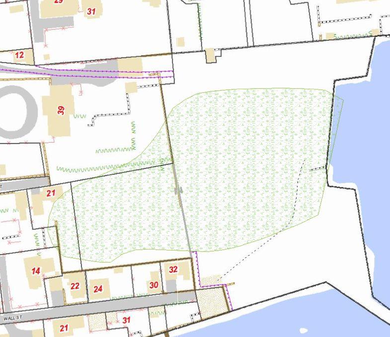
4 works closed a steam driven saw mill producing doors and window frames operated at the site until it was lost in a fire in SITE INFORMATION The property Appendix I contains legal description of the properties from deeds. A parcel map of the combined property from the Town of Stonington GIS database is shown below. The property is identified as Map/Book/Lot/Unit 101/38/9/. Combined GIS acreage is 3.6 acres. 3

5 4
, the property has been open space.")

6 The north, west and most of the southern boundaries are bounded by private homes. Acquisition history The Dodge Paddock was purchased in 1980 and Beal Preserve was received as a donation in Land use history Since the loss of the sawmill (noted above in the Historical section), the property has been open space. Open space in the borough of Stonington is extremely limited there are only three areas of any size (the other two are the Town Dock area and Stonington Point / Lighthouse Museum area). The original donor of the Beal Preserve has use of part of the property for a garden for as long as she remains in her home and certain easements are associated with the former Dodge properties on Church Street. Public use resources The property is open to the public for all standard Avalonia passive recreational activities. Bicycle riding and horseback riding are not permitted. The property is posted with use restrictions. The trail is not blazed but there is little need as the property is not large and there are no trees on which to post trail markers. There is an entrance sign describing the historical use. As there are natural stone and sea wall boundaries, it is not necessary to post boundary signs extensively. When the original donor vacates her abutting home, it may be necessary to post the western 5
7 boundary. Public benefit of the protected property: The property is a significant natural area that qualifies as being preserved for a conservation purpose under 26 US Code 170(h)(4): (4) Conservation purpose defined (A) In general For purposes of this subsection, the term conservation purpose means (i) the preservation of land areas for outdoor recreation by, or the education of, the general public, (ii) the protection of a relatively natural habitat of fish, wildlife, or plants, or similar ecosystem, (iii) the preservation of open space (including farmland and forest land) where such preservation is (I) for the scenic enjoyment of the general public, or (II) pursuant to a clearly delineated Federal, State, or local governmental conservation policy, and will yield a significant public benefit, or (iv) the preservation of an historically important land area or a certified historic structure. Natural resources ANIMALS, VEGETATION, INSECTS, AND BIRDS See Appendix 6

8 SOILS AND BEDROCK GEOLOGY HYDROLOGIC FEATURES 7
9 8
10 SPECIAL FEATURES AND CULTURAL RESOURCES From an Avalonia Trails Newsletter: Nature Preserve a Hidden Gem in Heart of Boro By Jean Fiore STONINGTON Shhhh. There s a secret in the borough. Tucked behind the mansions of Main Street is a 2.6-acre nature preserve that borders Little Narragansett Bay. It is known as Dodge Paddock and Beal Preserve, two contiguous properties belonging to Avalonia Land Conservancy, and open to the public from dawn to dusk daily. In recent months, Conservancy members and neighbors have extended the main pathway to form a circular trail along the perimeter of the paddock and preserve, affording inspiring vistas of village homes as well as nearby Salt Acres, Sandy and Napatree Points, and the outer breakwater of Stonington Harbor. Additionally, a new pathway winds through the center of the parcel enabling the visitor to delight in the whistle of wind through walls of golden grass and catch glimpses of cardinals and smaller avian varieties. Just offshore, waterfowl can be frequently spotted; and sunrise, with its many hues of pink, can be particularly pleasing from this vantage point. The half-acre-plus Beal Preserve, named for the Main Street family who donated the land to Avalonia, runs along the west side of the parcel. The formal gardens and manicured lawn of the Beal family estate abut this swath of land. A private vegetable and flower garden on the preserve, now dormant in winter, belongs to Mrs. Beal. Dodge Paddock is a 2-acre tract previously owned by the Dodge family. The stately white Church Street mansion with its many south-facing windows, just to the north of the paddock, was the former Dodge family estate. According to Avalonia president Anne Nalwalk, citizens of the borough led by the Beal Family rallied support and secured sufficient funds to purchase the tract from Dodge family heirs with the intention of preserving it. Avalonia purchased the land from these concerned citizens in 1980 and at the same time took possession of the adjacent Beal property. The paddock which is a fitting name for the property since it is fenced in by sea wall to the east, an enormous and impressive retaining wall to the north, and houses to the south and west was the site of a stoneware pottery works during the early 1800s run by the States family. Numerous pottery shards can still be found near the beginning of the seawall where a storm water drain empties into the harbor. Fine examples of the pottery may be viewed at the Old Lighthouse Museum located at Stonington Point and open from May 1 through October 31. Following the demise of States Pottery, a sawmill that produced doors and window frames operated on site in the mid-1800s. The shorefront area, known as Kiln Wharf, was also a busy distribution point. The land has been free of industry since 1865 when the 9
11 sawmill burned. The best way to access Dodge Paddock and Beal Preserve is via Wall Street, off of Main. Though a small parking area exists at the end of Wall Street, it may be easier to park along Main or Church Streets or at the Town Dock. One can admire the architecture of the many historic village homes while meandering toward the paddock and preserve. Certainly the best way to explore the village is by foot. Visitors to Dodge Paddock and Beal Preserve should refrain from picking from Mrs. Beal s private garden; and if accompanied by a dog, be sure to remove waste from pathways. Also, artifacts such as pottery shards need to remain on property. MANAGEMENT OBJECTIVES Stewardship policies Avalonia Land Conservancy Fee Land Stewardship Principles were approved on December 16, 2009 and the document is available at the Conservancy s office on Hatch Street in Mystic, CT. This document sets forth the general principles governing stewardship of all Avalonia properties. The document or any approved successor is hereby incorporated as part of this management plan. Protection Entrance signs are currently in place and shall be maintained or replaced as necessary to mark the entrance. An annual walk around the boundaries of the properties is required to ensure that boundary signs are in place and that there are no intrusions. Other surveillance should take place using due vigilance on occasional visits to the property. All motorized vehicles are prohibited on the properties except for maintenance. Maintaining properties appearance Trail currently mowed by neighbor. Litter control. Public use The preserve is open to the public for passive recreational use and hiking trails are maintained for the use of visitors. Motor vehicles, bicycle riding, and horseback riding are not permitted. Hunting and the use of firearms on the property including bow hunting and target practice are not permitted. Camping is not allowed. Dogs must be kept on a leash no longer than 7 feet long. Visitors are not allowed to pick vegetation or disturb wildlife excessively. Historical artifacts 10
12 should remain on the property. There is one interpretive sign on the property at present. Special events are permitted on the property at the discretion of the Stonington Town Committee or the Board of Directors. Events to date have consisted of small weddings. Enhancing wildlife habitat(s) Per a 1989 Avalonia policy: "The Mashantucket Land Trust, Inc. policy for the Dodge Paddock is to maintain the property as a meadow encouraging appropriate flora and fauna. A local stewardship committee will be established to oversea essential maintenance, to preserve and protect this natural environment, and to raise funds as necessary. All action by this committee is subject to approval by the MLT Board of Directors". Subsequent formation of town committees by the BOD indicates management of the property is now under the Avalonia Stonington Town Committee. The Preserve has several distinct habitat zones. The immediate rocky shoreline: This area is most affected by tidal changes. There are some areas of grassy marsh habitat, tidal pools, gravel and sand pockets and rock outcrops. There is no immediate need for enhancement here other than preservation. This area provides feeding, and roosting areas for birds: cormorants, geese and ducks, shorebirds, egrets and herons. Rocks and pools shelter invertebrates, crustaceans, fish and numerous alga/seaweed species. Shrub edges: Above the high tide line and along the higher elevations within the preserve are areas of shrubs and woody perennials. Some are native - many are not. [Domestic fruit trees, rugosa rose, poison ivy, goldenrod, asters]. Some are well in bounds and harbor migrant warblers in fall, nesting sparrows, finches, catbirds and others. These shrub areas should be maintained to provide cover, nesting and food. Other shrub pockets, along the north wall at eastern edge, are nearly completely invasive non-native multi-flora rose and honeysuckle. While providing some shelter, these areas will continue to expand and over dominate the grasslands that are a priority. These invasive areas should be managed to prevent spreading. A non-native raspberry patch, maintained by deed by the north wall neighbors, provides shelter and food. Grassland: The central and north and western area of both preserves has been maintained as grassland habitat. Grassland encourages small mammals, numerous insect species and grassland birds. It is in the original policy as stated for this property to maintain the property as meadow, encouraging appropriate flora and fauna. Some central areas of the field have begun to grow up as a dense sumac patch that, while native, can decrease the desirable field habitat. In other large portions of the field that is of poorer drainage and periodic flooding, the non-native and invasive 11
13 phragmites has been rapidly spreading into field areas, degrading the habitat by shading and out-competing native grasses and forbs. Wet Pool: This area receives fresh water drainage from surrounding neighborhood streets and is susceptible to seawater flooding during extreme high tides and storm surge events. This results in a general brackish pool with widely varying water levels and salinities, supporting some native tidal area plants and grasses but also harboring the densest growth of phragmites. In areas with greatest salinity, the pool is open, as the wet area has expanded and salinity decreases, the phragmites continue to grow degrading the habitat for most wildlife. One area, north of main pool and flushed with only fresh water is developing a nice stand of cattails which encourages fresh water wetland dependent species. The entire wet pool area has been drained over the years, with varying success, by outflow pipes to the ocean side, in attempts to promote drainage and decrease standing water and mosquitoes. Controlling invasive species Invasive species, most notably phragmites, are a significant issue on the preserves. CT DEEP reports state environmental managers and conservationists should be increasingly concerned about the threat to tidal wetlands and degradation to habitats. In this area they recommend a three-year herbicide application and mowing. Selective spraying in late summer is followed by mowing and mulching with low ground pressure equipment in a cycle over three successive years. A further study of the drainage system: culvert pipes and clamshell closure, and possible solutions will be conducted to see how it impacts the control and spread of the phragmites. Other non-native and invasive species, Japanese Honeysuckle and multi-flora rose should be cut back and a stump painting herbicide treatment regime should be followed until new growth stops. Other non-woody plants, loosestrife, reed canary grass and others should be hand removed when possible and selective herbicide treatment used to control. Poison Ivy, which is native and considered beneficial to wild life can be controlled in a similar manner to keep it off of paths. Erosion control and flooding Erosion has not been a significant problem except in a small area on the south side which over washes in extreme high tides and storm events. Flooding is a serious problem, mainly from fresh water runoff into the preserve, but also from extraordinary tidal events and storms. (Google Map 12
14 2003 shows extent and reach of flooding). History of the property examines various solutions over time, some successful, some done without proper permitting in early years. The culvert with clamshell closure, which was installed under CT DEEP guidance with appropriate guidance and work permits, has never functioned properly. Tides deliver sand and debris which clog pipe and keep the clamshell from functioning at all. Maintenance of the clamshell is allowed under the original permit, but clearing is time consuming. When water sits in the Paddock pool, mosquito breeding is a problem and has been addressed on an annual basis by the Town of Stonington Public Works Department mosquito control program. CT DEEP has completed (Feb 2013) elevation studies and assessment of drainage system and is working on a solution to control the flooding. Productive uses None. Scientific and educational activities New England Science and Sailing of Stonington uses the property for classes. Response to large natural disasters A 2012 super-storm drastically changed this property. The seawall was seriously damaged and the remaining seawall is deteriorating. Avalonia has no plans or funding to repair or replace the seawall. A contractor was hired to clear stones and remove debris. Special management considerations The close proximity to neighbors requires much sensitivity in regards to management. Research into best practices must occur before any major management actions or changes are undertaken. The neighbors have differing agendas, so it is important to keep in mind this property is a nature preserve. IMPLEMENTING THE PLAN Recurring and occasional requirements Stonington Town Committee members and neighbors frequently visit the site. Avalonia s phone number is posted at the entrances so that visitors can contact us for resolution of serious problems such as down trees, graffiti, dumping, or other damage to the property. Annual obligations A boundary walk around the outside perimeter the property is required. 13
15 Revolving mowing of parts of the property to control woody vegetation is required. Ensure path is mown either by neighbor or with Avalonia equipment. Short term plan (1 5 years) Remove dead tree behind Bentz property. (Cut down in fall 2012). Mowing portions of the property in rotation will control and mulch woody vegetation to maintain the field and meadows. Spring mowing is most desirable to provide winter coverage for small mammals, invertebrates and some seed source for birds. More vigorous cutting of brush areas along walls and center area of sumac is necessary to prevent further encroachment by shrubs into desirable meadow areas. (Ongoing) Conduct animal and bird surveys to assess inhabitants and migrant users. Document desirable vegetation as well as species targeted for removal. Work with CT DEEP to develop plan for three-year cycle of treatment, chemical and mechanical, to manage phragmites. CT DEEP will mow the phragmites areas according to their plan and with their equipment. Funds may need to be raised to support the program. (Ongoing ) Work with CT DEEP to develop a plan for better drainage. CT DEEP to secure necessary permits for any work to be done. Fund raise as necessary for plan implementation. (Ongoing elevation studies complete) Long term plan (5+ years) After 5 years, reassess phragmites control. Schedule for revising this plan This plan shall be reviewed at least every five years and updated as necessary. 14
16 APPENDICES I. Zoning map for property and surrounding area is available at the Stonington Town Hall or online at Deeds are available in Avalonia files, Stonington Town Hall and online at The Dodge Paddock: from Vol. 228 Page 21 September 25, 1980: A certain tract of land located with the buildings thereon situated on the waters of Little Narragansett Bay in the Town Of Stonington, County of New London and State of Connecticut and more particularly bounded and described as follows: On the south and east by the waters of Little Narragansett Bay; on the west by land now or formerly of Eric Kebben, et al., land formerly of Spaulding and Williams, et al., and land of the Borough of Stonington; and land on the north by land of the Calvary Episcopal Church Society, and land formerly of Thomas Miller and now in part of the Grantor herein and in part of Leon and Pauline Noe; together and subject to all rights of way and of rights appurtenant thereof. Subject to rights of way and easements as of record appear. The above-described premises are conveyed subject to the following restrictions and covenants, which shall bind the Grantee herein, its successors and assigns, forever: 1. The above-described tract shall be held and preserved in perpetuity in its natural, scenic and open space use in order to conserve and protect the animal, bird and plant populations thereon and prevent the use or development of said tract for any purpose or in any manner which would conflict with the maintenance of said tract in its natural scenic and open condition. 2. No building or structure of any kind except said small dock referred to hereinafter shall ever be constructed or place on said tract. Deed goes on to describe 12 right of way from Church Street property to the bay and the right to construct a small dock or have moorings for non-commercial use. Beal Preserve: from Vol. 232 Page 1054 November 6, 1981: A certain tract or parcel of land located in the Borough of Stonington, Town Of Stonington, County of New London and State of Connecticut and more particularly described as follows: Commencing at a point at the southwesterly corner of the herein described tract which point is at the southeasterly corner of the property now or formerly of Charles and Ivri Wormser and on the northerly side of the property now or formerly of Latimer Point Co. at a cut stone wall and thence south E along a stone wall ft. to a drill hole. Thence north E partially along a stone wall and along other property of the Grantee ft. to a drill hole set in said stone wall. Thence north W along other property of the Grantor a distance of ft. to an iron pin. Thence south W ft. to the point and place of the beginning. Said parcel contains 29,220 sq. ft. and is more particularly shown on a map entitled, Property Survey for Shirley C. Beal Scale: 1 = 20 date: August 1981, Harmony Street, Stonington, Connecticut, David D. Knox, P.E. & L. S.. By acceptance of this deed, grantee, its successors and assigns, hereby covenant and agree that the land described herein shall be forever maintained in its open and natural state. 15


17 II. Historical photos 1934 aerial (shows houses that were destroyed in 1938 hurricane) 1965 aerial


18 /15/2011 (Google Earth) 17

19 After super-storm Sandy October


20 19
21 20
22 21
23 22

24 23

25 24

26 25
27 26

28 27
29 Baseline Plant list: NN-Non Native, N-Native, I-Invasive Shrubs, Vines and Trees: Domestic fruit trees and Raspberry bushes, Rugosa Rose NN, Multiflora Rose NNI, Japanese Honesuckle NNI, Black Swallowwort NNI, Oriental Bittersweet NNI, Wineberry NNI, Groundsel Tree N, Bayberry N, Poison Ivy N, Virginia Creeper N, Viburnum (sp) N, Winged Sumac N, Cherry N. Woody Perennials, grasses, flowers. Asters (sp) N including Saltmarsh Aster and NewYork Aster, Goldenrod (sp) N, Blue Flag Iris N, Curly Dock NN, Common Cocklebur N, Evening Primrose N, Orache N, Purple Loosestrife NNI, Asparagus NN, Jimson Weed, Grasses, including Spartina Grasses N, in tidal zone, Panicum (sp)n meadow grass, Reed Canary Grass NNI, Multiple Rushes: Juncus species N, Sedges: Carex Species N, Cattails N in wet areas Phragmities NNI 28
Pequotsepos Brook Preserve
 AVALONIA LAND CONSERVANCY, Inc. P.O. Box 49, Old Mystic, CT 06372 Pequotsepos Brook Preserve Property Management Plan Maritime Drive Mystic, New London County, Connecticut Stonington Town Committee is
Planning for and Managing Open Space and Natural Areas
 Planning for and Managing Open Space and Natural Areas Increasingly, development proposals in Delaware include large amounts of open space and natural areas. While open space is important as a community
Master Plan for Preservation and Scenic Conservation (1995)
") 3.2 Master Plan for Preservation and Scenic Conservation (1995) The Master Plan for Preservation and Scenic Conservation was developed under the direction of the Guilford Preservation Alliance in the 1980s
3.2 Master Plan for Preservation and Scenic Conservation (1995) The Master Plan for Preservation and Scenic Conservation was developed under the direction of the Guilford Preservation Alliance in the 1980s
Wisconsin Dept. of Transportation November 2017
 Wisconsin Dept. of Transportation November 2017 Jennifer Gibson WisDOT Environmental Coordinator Mike Helmrick WisDOT Environmental Coordinator Background on compensatory wetland mitigation Site purpose
Study Area Map. Wasatch Hollow Open Space Restoration, Use, & Management Plan. Legend. Harrison Ave East. Roosevelt East.
 Harrison Ave Roosevelt Emerson «4 «5 Rosecrest 1900 East «3 1800 East Wasatch Hollow Open Space Restoration, Use, & Management Plan Study Area Map Legend «2 «1 Potential Access Location Emigration Creek
Coquitlam River Riparian Planting
 Coquitlam River Riparian Planting Year Four Year Four Report, March 2016 Prepared for: Fish and Wildlife Compensation Program Prepared by: Watershed Watch Salmon Society and the Kwikwetlem First Nation
STATE OF NORTH CAROLINA DECLARATION OF
 Prepared by and Return to: Orange County Parcel Identification Number(s): STATE OF NORTH CAROLINA COUNTY OF ORANGE DECLARATION OF RESTRICTIVE COVENANTS THIS DECLARATION OF RESTRICTIVE COVENANTS ( Declaration
Burrowing Owl Habitat Project at the Albany Plateau. (a component project of the Gilman Street Playing Fields Project City of Berkeley) March 10, 2006
 March 10, 2006") Burrowing Owl Habitat Project at the Albany Plateau (a component project of the Gilman Street Playing Fields Project City of Berkeley) March 10, 2006 Submitted by The City of Berkeley Project history During
Burrowing Owl Habitat Project at the Albany Plateau (a component project of the Gilman Street Playing Fields Project City of Berkeley) March 10, 2006 Submitted by The City of Berkeley Project history During
Rocky Areas Project Guidance HABITAT
 Rocky Areas Project Guidance HABITAT Introduction Rocky habitats are surface areas dominated by exposed rock, such as mountain peaks, inland cliffs, buttes and rocky outcrops. In many cases, rocky areas
Master Plan Objectives and Policies
 Master Plan Objectives and Policies Introduction This chapter identifies the Park issues and recommended policies established by this Master Plan. The issues were identified through meetings with staff,
Planning for Staten. Habitat Restoration and Green Infrastructure. Island s North Shore
 Habitat Restoration and Green Infrastructure Planning for Staten Island s North Shore Community Board 1 March 1, 2018 NYC Parks Forestry, Horticulture, and Natural Resources Funded by the NYS Department
April 11, 2016 Park Board Chair and Commissioners General Manager Vancouver Board of Parks and Recreation New Brighton Salt Marsh - Preferred Concept
 TO: FROM: SUBJECT: April 11, 2016 Park Board Chair and Commissioners General Manager Vancouver Board of Parks and Recreation New Brighton Salt Marsh - Preferred Concept RECOMMENDATION A. THAT the Vancouver
ADDENDUM TO BIOLOGICAL SCOPING SURVEY REPORT, BOTANICAL SURVEY AND WETLAND DELINEATION
 ADDENDUM TO BIOLOGICAL SCOPING SURVEY REPORT, BOTANICAL SURVEY AND WETLAND DELINEATION FOR AVALON INN (APN 069-241-27 & -04) 1201 & 1211 NORTH MAIN STREET FORT BRAGG, CA MENDOCINO COUNTY prepared for:
A Master Plan for High Park s Hillside Garden and other Ornamental Gardens: Recommendations from the High Park Natural Environment Committee
 www.highparknature.org mail@highparknature.org A Master Plan for High Park s Hillside Garden and other Ornamental Gardens: Recommendations from the High Park Natural Environment Committee September 2015
MOWING AND WILDLIFE: MANAGING OPEN SPACE FOR WILDLIFE SPECIES
 PENNSYLVANIA GAME COMMISSION MOWING AND WILDLIFE: MANAGING OPEN SPACE FOR WILDLIFE SPECIES Many property owners want clean-cut, attractive lawns or fields. However, what appears to be a healthy lawn to
Wild about Bolnore. Welcome to Bolnore Village, situated in the beautiful West Sussex countryside. ResIDENTS INFORMATION GUIDE
 Wild about Bolnore Welcome to Bolnore Village, situated in the beautiful West Sussex countryside. Sustainability has been a key factor in the development of the village and considerable effort has been
Canyon Lake Master Plan Revision Public Information Meeting March 18, 2016
 Canyon Lake Master Plan Revision Public Information Meeting March 18, 2016 Marcus Schimank Canyon Lake Manager Capital Regional Office U.S. Army Corps of Engineers Fort Worth District US Army Corps of
Weston s Wetlands, Stormwater, & Open Space
 Weston s Wetlands, Stormwater, & Open Space Weston s Wetlands, Stormwater, & Open Space Conservation Commission Role and Responsibilities Laws that protect wetlands What residents can do to protect wetlands
Community Conservation Workshop. Saranac River Basin Communities
 Community Conservation Workshop Saranac River Basin Communities 2 Community Conservation Program Welcome! We have designed a Community Conservation Program that listens to the needs of community members.
Hunts Point Landing, Bronx, New York
 Hunts Point Landing, Bronx, New York Sustainable Shorelines in an Urban Environment John Roebig, PhD. HDR Engineering, Inc. John.Roebig@hdrinc.com Promoting Resilient Shorelines along the Hudson River
PRE-DESIGN CONCEPT REPORT GRAND CANAL RESTORATION
 PRE-DESIGN CONCEPT REPORT GRAND CANAL RESTORATION Project Background November 19, 2007 Executive Summary The Grand Canal is an important tidal waterway in the Venice community of Los Angeles, California,
Storm Water Quality and Shoreline Restoration Improvements - Grant Funding Request City of Mound Carlson Park Bolton & Menk Project No.
 September 15, 2016 Brett Eidem Cost Share Grant Administrator Minnehaha Creek Watershed District 15320 Minnetonka Boulevard Minnetonka, MN 55345 RE: Storm Water Quality and Shoreline Restoration Improvements
SITE INTRODUCTIONS AND OVERVIEW
 SITE INTRODUCTIONS AND OVERVIEW The City s formal Open Space Program was established in 1990 to implement long-standing policies that called for the protection of the farmlands and wild areas that surround
Preliminary Sketch Plan for Fort Hunter Park
 Preliminary Sketch Plan for Fort Hunter Park Public Presentation November 19, 2009 Dauphin County Parks and Recreation 100 Fort Hunter Road Harrisburg, PA 17110 (717) 599-5188 www.dauphinc.org THOMAS COMITTA
LOS ANGELES AIRPORT/EL SEGUNDO DUNES Specific Plan
 LOS ANGELES AIRPORT/EL SEGUNDO DUNES Specific Plan Ordinance No. 167,940 Effective June 28, 1992 TABLE OF CONTENTS MAP Section 1. Section 2. Section 3. Section 4. Section 5. Section 6. Specific Plan Area
Community Conservation Workshop. Lake Placid
 Community Conservation Workshop Lake Placid 2 Community Conservation Program Welcome! We have designed a Community Conservation Program that listens to the needs of community members. We are conducting
The Reedville Living Shoreline
 E The Reedville Living Shoreline Teaching Garden Garden This garden was designed to demonstrate an environmentally friendly approach to shoreline stabilization and natural landscaping. Established in 2005
Lewisville Lake Master Plan Revision Public Information Meeting May 2 & 4, 2017
 Lewisville Lake Master Plan Revision Public Information Meeting May 2 & 4, 2017 Presented By Rob Jordan Lake Manager U.S. Army Corps of Engineers Fort Worth District US Army Corps of Engineers Purpose
POLLINATOR HABITAT PLANTING
 POLLINATOR HABITAT PLANTING Michigan CRP - SAFE CP-38E Pollinator Natural Resources Conservation Service (NRCS) Pollinators provide a very important ecological service. Approximately three quarters of
Procedures IV. V. Rural Road Design Option
 i IV. Procedures A. All applicants required to prepare a Conservation Design Subdivision shall provide the Planning Board with a conceptual conventional subdivision design as well as a proposed layout
Marshview Park. Concept Briefing and Feedback Session. Aquarium/Owls Creek Plan Steering Committee March 20, 2012
 Marshview Park Concept Briefing and Feedback Session Aquarium/Owls Creek Plan Steering Committee March 20, 2012 1 Outline of Today s Discussion Introductions Context for Marshview Park Site analysis -
SOIL EROSION AND SEDIMENT CONTROL
 SOIL EROSION AND SEDIMENT CONTROL SECTION 1: AUTHORITY, TITLE AND PURPOSE 11. STATUTORY AUTHORIZATION This ordinance is adopted pursuant to the provisions of the Federal Water Pollution Control Act 86
Triangle Land Conservancy Conservation Area Monitoring Report Carolina North
 Triangle Land Conservancy Conservation Area Monitoring Report Carolina North Property Name: Bolin Creek West Conservation Area Date of first visit: 3.12.14 County: Orange Date of second visit: 6.5.14 Property
DRAFT ALDER CREEK FARM MASTER PLAN
 DRAFT ALDER CREEK FARM MASTER PLAN Lower Nehalem Community Trust Mission: To preserve land and nurture conservation values in partnership with an engaged community in the Nehalem region of the Oregon Coast
36.1. PURPOSE APPLICABILITY DESIGN REVIEW GUIDELINES
 CHAPTER 36: DESIGN STANDARDS 36.1. PURPOSE The purpose of this chapter is to ensure that projects are designed and constructed consistent with the Community Design Subelement of the Land Use Element and
Hidden Pointe Landscape Master Plan. June, archi terra
 Hidden Pointe Landscape Master Plan June, 2006 t h e archi terra g r o u p 1 Table of Contents Background Purpose and Goals of the Master Plan Master Plan Process Existing Conditions Entrance Hidden Pointe
Exhibit A. 8:9 Scuffletown Rural Conservation District
 Exhibit A 8:9 Scuffletown Rural Conservation District 8:9.1 Intent and Purpose The Scuffletown Rural Conservation (SRC) District is intended to provide for residential development that supports the development
North Oakville East Parks Facilities Distribution Plan. November, 2009
 North Oakville East November, 2009 POLICY CONTEXT 1) Purpose a) The purpose of this document is to be a guide for the location, configuration, design and development of the parks system for the North Oakville
Arana Gulch Park Master Plan
 809 Center Street, Santa Cruz, CA 95060 Arana Gulch Park Master Plan Executive Summary The Arana Gulch Master Plan completes the last master planning work for the parks and open spaces within the City
STAFF REPORT FOR STANDARD COASTAL DEVELOPMENT PERMIT #CDP FEBRUARY 26, 2015 CPA - 1 PO BOX 238 APTOS, CA 94001
 STAFF REPORT FOR STANDARD COASTAL DEVELOPMENT PERMIT #CDP 2014-0030 FEBRUARY 26, 2015 CPA - 1 OWNER/APPLICANT: AGENT: REQUEST: HANS HEIM PO BOX 238 APTOS, CA 94001 JAMES HAY PO BOX 762 MENDOCINO, CA 95460
The following principles guide the development of goals and strategies to protect and promote these amenities:
 OPEN SPACE/PARKS/TRAILS/RECREATION GOALS/STRATEGIES Cherry Hills Village is a living environment that offers low density development, open areas, public scenic vistas, public trails and public parks. This
Morro Shoulderband Snail Protocol Survey Report for the Parcel at 3093 Beachcomber Drive, Morro Bay, San Luis Obispo County, California
 Morro Shoulderband Snail Protocol Survey Report for the Parcel at 3093 Beachcomber Drive, Morro Bay, San Luis Obispo County, California Prepared for: John K. Construction Inc. Prepared by: SWCA Environmental
Landscaping for Wildlife
 Landscaping for Wildlife Mid-Atlantic Ecological Landscape Partnership (MAEscapes) York County Conservation District 2008 YCCD 1 Presenter Gary R. Peacock, Watershed Specialist York County Conservation
New Brighton Park Shoreline Habitat Restoration Project
 Vancouver Board of Parks and Recreation and Port Metro Vancouver New Brighton Park Shoreline Habitat Restoration Project Conceptual Design Public Consultation August 26 September 9, 2015 Discussion Paper
City of Sun Prairie Wetland Buffer Reduction Request
 City of Sun Prairie Wetland Buffer Reduction Request Westside Development Area January 9, 2017 Prepared by: City of Sun Prairie 300 E. Main Street Sun Prairie, WI 53590 BACKGROUND The City of Sun Prairie
WHERE. is vegetation managed? Power lines. Rail lines. Oil and gas sites. Roadsides
 VEGETATION management matters You may see workers performing maintenance in your community to control vegetation. Their purpose is to control overgrown vegetation where it creates a safety, health, occupational
VALLEY VIEW POND Q&A. This item will be discussed under the First Reading portion of the agenda at the July 17, 2012 Village Council meeting.
 VALLEY VIEW POND Q&A This item will be discussed under the First Reading portion of the agenda at the July 17, 2012 Village Council meeting. 1. Please provide a history of the pond including Village maintenance
Town of Dennis Department of Natural Resources. Mission
 Stewardship Manual Town of Dennis Department of Natural Resources Mission To protect, manage and enhance the natural resources within the Town of Dennis while providing services and facilities that provide
Point-No-Point Tide-Gate & Outfall Replacement Project. Briefing Memo 2013
 Point-No-Point Tide-Gate & Outfall Replacement Project Briefing Memo 2013 This memo provides an initial outline of the proposed Point-No-Point (PNP) Tide-Gate and Outfall replacement project. The current
Joe Pool Lake Master Plan Revision Public Information Meeting May 23, 2017
 Joe Pool Lake Master Plan Revision Public Information Meeting May 23, 2017 Presented By Jason Owen Lake Manager U.S. Army Corps of Engineers Fort Worth District US Army Corps of Engineers Purpose of this
Polpis Bike Path. General Impacts: 1.47 acres forested, marsh, shrub swamp
 Polpis Bike Path File No.: 199201570 City and State: Nantucket, MA General Impacts: 1.47 acres forested, marsh, shrub swamp Functions and Values Lost: (from EA/SOF) Floodflow Alteration Groundwater Discharge
TOWN OF SPRINGFIELD, NEW HAMPSHIRE
 TOWN OF SPRINGFIELD, NEW HAMPSHIRE NATURAL RESOURCES INVENTORY EXECUTIVE SUMMARY March 2008 Prepared by: Watershed to Wildlife, Inc. Natural Resource Consultants 42 Mill Street, Suite 3 Littleton, NH 03561
Palmdale Municipal Code (Excerpts) Title 14: ENVIRONMENTAL MANAGEMENT Chapter 14.04: JOSHUA TREE AND NATIVE DESERT VEGETATION PRESERVATION
 Title 14: ENVIRONMENTAL MANAGEMENT Chapter 14.04: JOSHUA TREE AND NATIVE DESERT VEGETATION PRESERVATION") Palmdale Municipal Code (Excerpts) Title 14: ENVIRONMENTAL MANAGEMENT Chapter 14.04: JOSHUA TREE AND NATIVE DESERT VEGETATION PRESERVATION 14.04.010 Purpose and intent. It is determined by the City Council
Palmdale Municipal Code (Excerpts) Title 14: ENVIRONMENTAL MANAGEMENT Chapter 14.04: JOSHUA TREE AND NATIVE DESERT VEGETATION PRESERVATION 14.04.010 Purpose and intent. It is determined by the City Council
ARTICLE IV: DEVELOPMENT STANDARDS 404 MASTER PLANNING
 IV 13 404 MASTER PLANNING Master Planning through the Site Analysis (Master Planning Site Analysis) or Planned Development (Master Planning Planned Development) is provided to encourage development which
Yadkin River Greenway Feasibility Study Fact Sheet Village of Clemmons, Town of Lewisville, Town of Bermuda Run
 Fact Sheet Village of Clemmons, Town of Lewisville, Town of Bermuda Run Project Background The Yadkin River Greenway Feasibility Study is a joint project with the Village of Clemmons, the Town of Bermuda
Healthy for Bees: Healthy for People. Managing the grounds of public buildings for pollinators
 Healthy for Bees: Healthy for People Managing the grounds of public buildings for pollinators Introduction As a public authority, your organisation now has a legal duty to safeguard and improve the natural
DECLARATION OF COVENANT FOR IMPERVIOUS SURFACE LIMIT
 RECORDING REQUESTED BY AND WHEN RECORDED MAIL TO: DECLARATION OF COVENANT FOR IMPERVIOUS SURFACE LIMIT Grantor: _ Grantee: King County Legal Description: Additional Legal(s) on: Assessor's Tax Parcel ID#:
Outline MANAGING INVASIVE PLANTS ON YOUR LAND. Invasive Species. Definitions 1/12/2015
 Outline General Invasive Plant Ecology Identification of New Invasive Plants Management Principles MANAGING INVASIVE PLANTS ON YOUR LAND Chris Evans, Illinois Invasive Species Campaign Invasive Species
McArthur Swamp Planning Unit. Fish, Plant, and Wildlife Habitat MCARTHUR SWAMP PLANNING UNIT
 McArthur Swamp Planning Unit Fish, Plant, and Wildlife Habitat Conduct surveys of the planning unit to identify biological resources and enable their protection. Most of the McArthur Swamp land acreage
West Little Pimmit Storm Sewer & John Marshall Green Street Projects. July 7, 2015 Nottingham Elementary School
 West Little Pimmit Storm Sewer & John Marshall Green Street Projects July 7, 2015 Nottingham Elementary School Project Timeline February 2015: Archeological study of island, including historic spring location,
OPEN SPACE CHAPTER 7: OVERVIEW. Preserve open space to protect natural resources, enhance character and provide passive recreation opportunities
 CHAPTER 7: OPEN SPACE OVERVIEW Ridgefield has made tremendous progress permanently preserving areas of town as open space. Open space preservation can serve many important purposes, including: protect
ME DOT Route 3. File No.: City and State: Bar Harbor, ME
 ME DOT Route 3 File No.: 199600361 City and State: Bar Harbor, ME General Impacts: 0.28 acre tidal emergent 0.77 acre non-tidal forested 0.15 acre non-tidal emergent 0.51 acre non-tidal scrub-shrub Functions
Town of Groton, Connecticut
 Town of Groton, Connecticut Planning Commission Regular Meeting Minutes Office of Planning and Development Services Town Hall Annex 134 Groton Long Point Road Groton, CT 06340 860-446-5970 Tuesday, November
Chapter 5: Natural Resources and Environment
 NATURAL RESOURCES AND ENVIRONMENT 5-1 5 Chapter 5: Natural Resources and Environment BACKGROUND AND INTENT Urban expansion represents the greatest risk for the future degradation of existing natural areas,
Triangle Land Conservancy Conservation Area Monitoring Report Carolina North
 Triangle Land Conservancy Conservation Area Monitoring Report Carolina North Property Name: Bolin Creek West Conservation Area Date of visit: April 11, 2018 County: Orange Property Type: Restrictive Covenants
Tentatively Selected Plan within Harlem River, East River and Western Long Island Sound Planning Region. First Level Costs. Federal Non-Federal Total
 HARLEM RIVER, EAST RIVER AND WESTERN LONG ISLAND SOUND PLANNING REGION Flushing Bay and Creek Ecosystem Restoration Source Feasibility Study Background Study Resolution (1994), Reconnaissance Report (1996),
RECREATION AND OPEN SPACE ELEMENT GOALS, OBJECTIVES, AND POLICIES
 RECREATION AND OPEN SPACE ELEMENT GOALS, OBJECTIVES, AND POLICIES Goal 7 To provide park facilities, recreation programs, and open space resources that are safe, adequate, and accessible to all City residents,
LILAC Housing: Site Management Plan
 LILAC Housing: Site Management Plan Prepared by: Joe Atkinson. Date: 30/10/2011 Version 1.0 Relevant Legislation & Policy Conservation Regulations 1994, 2007, 2009, 2010 Wildlife & Countryside Act 1981;
ALTERNATIVE SHORELINE MANAGEMENT IN COASTAL MISSISSIPPI
 ALTERNATIVE SHORELINE MANAGEMENT IN COASTAL MISSISSIPPI Project supported via financial assistance provided by the Coastal Zone Management Act of 1972, as amended, administered by the Office of the Ocean
The Bruce Trail: your good neighbour
 The Bruce Trail: your good neighbour HELP US PROTECT OUR CONSERVATION CORRIDOR The Bruce Trail Conservancy Our Mission The Bruce Trail Conservancy is a charitable organization committed to establishing
City of Shady Cove Riparian Ordinance Ordinance XXX
 1 Updated October 8, 2015 City of Shady Cove Riparian Ordinance Ordinance XXX This language is to be located in Chapter 155 of the Shady Cove Code of Ordinances. This will affect property inside city limits,
Triangle Land Conservancy Conservation Area Monitoring Report Carolina North
 Triangle Land Conservancy Conservation Area Monitoring Report Carolina North Property Name: Bolin Creek West Conservation Area Date of visit: 2.18.13, 2.18.13, 3.13.13, and 6.10.13 County: Orange Property
RECREATION AND OPEN SPACE ELEMENT GOALS, OBJECTIVES, AND POLICIES
 RECREATION AND OPEN SPACE ELEMENT GOALS, OBJECTIVES, AND POLICIES GOALS, OBJECTIVES AND POLICIES GOAL 1: TO PROVIDE A FULL RANGE OF RECREATIONAL ACTIVITIES THAT ARE ACCESSIBLE, COMPATIBLE AND CONTINUOUS
OPERATIONS & MAINTENANCE MANUAL FOR POST CONSTRUCTION MEASURES
 OPERATIONS & MAINTENANCE MANUAL FOR POST CONSTRUCTION MEASURES THE CARMONY BUILDING PARAGON REALTY NORTH GREEN STREET BROWNSBURG, HENDRICKS COUNTY INDIANA 8365 Keystone Crossing, Suite 201 Indianapolis,
AVONDALE ESTATES GREENSPACE AD-HOC COMMITTEE
 AVONDALE ESTATES GREENSPACE AD-HOC COMMITTEE INVENTORY AND RECOMMENDATIONS REPORT November 7, 2018 Our Mission Statement: To provide assistance and support, through professional expertise in matters of
Rule D Wetland and Creek Buffers
 Rule D Wetland and Creek Buffers 1 Policy It is the policy of the Board of Managers to ensure the preservation of the natural resources, recreational, habitat, water treatment and water storage functions
Appendix R - Management Plan for the Buffers and Stormwater Management Facilities
 - Management Plan for the Buffers and Stormwater Management Facilities Purpose. The developer, in an effort to protect water quality and improve on-site habitat values, proposes to implement a Management
I. STAFF POLICY RECOMMENDATIONS. The following RMP policy strategies are proposed by staff in support of a Scenic Resource Protection Program:
 Policy Consideration: Scenic Resource Protection Program Status: For Consideration by the Highlands Council at September 14, 2006 Work session Date: September 12, 2006 I. STAFF POLICY RECOMMENDATIONS The
Oxford Brookes University Biodiversity Action Plan (BAP) V2
 V2") Oxford Brookes University Biodiversity Action Plan (BAP) V2 Background Oxford Brookes University is based at three sites in Oxford: Headington, Wheatley and Harcourt Hill, and has a presence across numerous
Oxford Brookes University Biodiversity Action Plan (BAP) V2 Background Oxford Brookes University is based at three sites in Oxford: Headington, Wheatley and Harcourt Hill, and has a presence across numerous
2.4 FUTURE LAND USE ELEMENT Goals, Objectives and Policies
 GOAL 1: To create developmental patterns that direct future growth to appropriate areas on campus, in a manner that promotes the educational mission of the University, the protection of environmentally
THE INS AND OUTS OF NATIVE PLANTINGS. Aimee Zimmermann Liz Reed
 THE INS AND OUTS OF NATIVE PLANTINGS Aimee Zimmermann Liz Reed EOT SWCD WHAT DO WE DO? Irrigation Scheduling and Nutrient Management Native Seedings and Drill Rental Tree Sales and Tree Planting Water
MINUTES CHESAPEAKE BAY PRESERVATION AREA BOARD VIRGINIA BEACH, VIRGINIA JULY 24, 2017
 MINUTES CHESAPEAKE BAY PRESERVATION AREA BOARD VIRGINIA BEACH, VIRGINIA JULY 24, 2017 Chair Mr. Jester, called to order the Chesapeake Bay Preservation Area Board meeting in the City Council Chambers,
STREAM BUFFER PROTECTION AND MANAGEMENT
 ORDINANCE NO. 753 AN ORDINANCE AMENDING THE CODE OF ORDINANCES OF THE CITY OF PLEASANT HILL, IOWA 1998, BY ESTABLISHIING CHAPTER 104, STREAM BUFFER PROTECTION AND MANAGEMENT Be it enacted by the City of
Roadside Mowing. Spot mowing of noxious weeds should be done as necessary to reduce propagation.
 Public Works Department Road and Bridge Division Roadside Mowing 1.0 Policy The primary purpose for planting and maintaining a vegetative cover on roadside areas is to prevent erosion of the soil. It is
Flat Lake, Highway 103, HADD Compensation Project (DFO HADD Authorization 03-G8-068): 2010 Vegetation Monitoring
: 2010 Vegetation Monitoring") Flat Lake, Highway 103, HADD Compensation Project (DFO HADD Authorization 03-G8-068): 2010 Vegetation Monitoring Year 5 Final Diane LaRue, Vegetation Consultant Environmental Services, NSTIR Monitored
Flat Lake, Highway 103, HADD Compensation Project (DFO HADD Authorization 03-G8-068): 2010 Vegetation Monitoring Year 5 Final Diane LaRue, Vegetation Consultant Environmental Services, NSTIR Monitored
Meeting Agenda. City of Guelph. River Systems Advisory Committee. Agenda Items. Item 1, 2 and 3. Item 4 Ward to Downtown Pedestrian Bridge
 Meeting Agenda City of Guelph River Systems Advisory Committee September 19, 2018 City Hall, Meeting Room B From 4:00 to 6:00 p.m. Meeting Chair: Mariette Pushkar Agenda Items Welcome to all Item 1, 2
Invasive Plants Picture Card Set
 Grades 4 & 5 Curriculum nvasive Plants Picture Card Set Donna R. Ellis, University of Connecticut A S Autumn Olive Autumn olive was introduced purposefully in the mid 1800 s from Asia to improve wildlife
SECTION II SECTION II STATEMENT OF GOALS, OBJECTIVES, PRINCIPLES, ASSUMPTIONS, POLICIES AND STANDARDS
 STATEMENT OF GOALS, OBJECTIVES, PRINCIPLES, ASSUMPTIONS, POLICIES AND STANDARDS 1 2 STATEMENT OF GOALS, OBJECTIVES, PRINCIPLES, ASSUMPTIONS, POLICIES AND STANDARDS INTRODUCTION The New Jersey Municipal
Site Preparation. What to Look for in a Vegetation Implementation Plan. Plant Community Goals (restoration checklist) Plant Community Goals
 Plant Community Goals") What to Look for in a Vegetation Implementation Plan Plant Community Goals (restoration checklist) Defining Project Goals Goals Site Preparation Mixes and Plant ing/planting Zone Map ing/planting Methods
What to Look for in a Vegetation Implementation Plan Plant Community Goals (restoration checklist) Defining Project Goals Goals Site Preparation Mixes and Plant ing/planting Zone Map ing/planting Methods
The Salt Marsh Advancement Zone Assessment of Connecticut
 The Salt Marsh Advancement Zone Assessment of Connecticut Front cover image: Salt marsh advancement zones in Stratford, CT from the Comprehensive Map Book of Stratford, CT. Table of Contents Introduction...
Homeowners Guide to Stormwater BMP Maintenance
 Homeowners Guide to Stormwater BMP Maintenance What You Need to Know to Take Care of Your Property Rain Barrel Dry Well Rain Garden Pervious Asphalt Porous Pavers City of El Monte Stormwater BMP Management
Lake Nokomis Shoreline Enhancement Project
 Lake Nokomis Shoreline Enhancement Project Community Meeting 2 February 13, 2018 Agenda Current Problems Project Goals Project Status Existing Conditions Community Input Draft Schematic Design Long-term
Lawrencetown Beach & Rainbow Haven Beach
 Lawrencetown Beach & Rainbow Haven Beach Public Engagement Session Wednesday, September 27 th, 2017 6:00pm 8:00pm Cole Harbour Place 51 Forest Hills Pkwy, Dartmouth Agenda Welcome & Introductions Overview
TOWNSHIP OF LOGAN SOIL & FILL IMPORTATION AND PLACEMENT APPLICATION SUBMITTAL CHECKLIST
 TOWNSHIP OF LOGAN SOIL & FILL IMPORTATION AND PLACEMENT APPLICATION SUBMITTAL CHECKLIST Applications: 5 copies of application - Applicant will reproduce the copies at his/her costs. The Township Clerk
PCAL Case Study Open Spaces: Blayney Heritage Park
 PCAL Case Study Open Spaces: Blayney Heritage Park Introduction Blayney Heritage Park is an area of high quality open space that offers a range of active and passive recreation facilities. The multi-purpose
The Napa River Flood Protection Project
 The Napa River Flood Protection Project Creating Flood Protection and Restoring Geomorphic and Biological Processes Jeremy Sarrow, Napa County Flood Control & Water Conservation District June 2, 2014.
Landscape Design Requirements and Guidelines for Private Lots in the Old Town North Neighborhood
 Landscape Design Requirements and Guidelines for Private Lots in the Old Town North Neighborhood July 2009 Prepared for High Country Management on behalf of the OTN Homeowners Association, by Christine
ECOLOGICAL ADVICE SERVICE
 ECOLOGICAL ADVICE SERVICE TO: FROM: Guy Wilson Marie Thibault DATE: 11 th August 2016 SUBJECT: CA/16/01502/FUL / Land adjoining Goose Farm, Canterbury Thank you for requesting advice on this application
2016 Vegetation Monitoring Report ERA Project # Prepared for: Downers Grove Park District
 Lyman Woods Streambank Stabilization Project Site Area II, Phase III Downers Grove, Illinois 2016 Vegetation Monitoring Report ERA Project #100301 Prepared for: Downers Grove Park District December 2016
CITY OF SAN MATEO ORDINANCE NO
 CITY OF SAN MATEO ORDINANCE NO. 2012-4 AMENDING SECTION 27.38.090, OPEN SPACE REQUIREMENTS, OF CHAPTER 27.38, CBD DISTRICTS-CENTRAL BUSINESS DISTRICT, SECTION 27.64.023, PARKING PROHIBITED ON LAWNS, FLOWERS,