Bernardo Aliaga. Ken Gledhill. Laura Kong. Programme Specialist Tsunami Unit UNESCO/IOC ICG/CARIBE EWS Technical Secretary
|
|
|
- Chester Berry
- 5 years ago
- Views:
Transcription
1 UNESCO IOC CTIC US NOAA ITIC Regional Training Workshop on Strengthening Tsunami Warning and Emergency Response Standard Operating Procedures and the Development of the ICG/CARIBE-EWS PTWC New Enhanced Products 4-8 November 2013, La Romana, Dominican Republic Public Coastal Evacuation: alerting and moving people, Inundation modeling and maps, Evacuation routes and signage, safe return evacuation planning: Role and value of Tsunami inundation modelling Bernardo Aliaga Programme Specialist Tsunami Unit UNESCO/IOC ICG/CARIBE EWS Technical Secretary Ken Gledhill GeoNet Project Director - Chair, Pacific Tsunami Warning and Mitigation System GNS Science, New Zealand Laura Kong Director, UNESCO/IOC NOAA ITIC
2 The starting point is to have inundation maps Evacuation zone boundaries can be determined using a variety of hazard models. Zones ideally need to represent an envelope around all possible inundations from all known tsunami sources. The high degree of uncertainty in tsunami source models, and the very time consuming and resource intensive nature of modeling make this comprehensive approach to tsunami risk assessment unlikely in many countries. The recommended approach to developing tsunami evacuation zones is to map now, and progressively refine the accuracy of boundaries as capacity improves over time. Credible scenarios Expected Arrival Time Worst case/probabilistic approach Level one: thumb estimate -> Yamaguchi Level two: Pre-defined sources, web platforms -> ComMIT Level three: finite differences models -> MOST, COMCOT, NEOWAVE, others
3 Tsunami Modeling Why? Historical tsunamis allow scientists to understand how tsunamis behave Tsunamis are high impact, but infrequent Therefore, modeling scenarios essential Simulate: When and how tsunami will hit coast? Where highest? How far floods inland? Where strong currents are? Science Result: Inundation map - credible scenarios Public Safety Result: Evacuation maps - community
, water depth Gives details on Prolonged wave activity (extended time of dangerous waves) height amplification (due to summation of waves at different")
4 Modeling of Near-field Tsunami Wave Resonance Studies provide information on near-shore interactions Depends on near-shore morphology coastline shapes (island, shelf, bays ), water depth Gives details on Prolonged wave activity (extended time of dangerous waves) height amplification (due to summation of waves at different periods)

5 The 2010 Maule Earthquake Tsunami Resonance Study for Near-field Tsunami

6 The 2010 Maule Earthquake Tsunami Resonance Study for Near-fleld Tsunami


7 1946 Alaska Tsunami at Hawaii Propagation, Near-Shore Interactions, Inundation Hawaii Kwok Fai Cheung, Univ. of Hawaii Maui County Kahalui, Maui


8 1946 Alaska Tsunami at Hawaii Illustration of Regional Resonance Resonance min Bathymetry Kwok Fai Cheung, Univ. of Hawa

9 1946 Alaska Tsunami at Kahalui, Maui, Hawaii Wave Transformation over Reefs and Inundation Kwok Fai Cheung, Univ. of Hawaii
10 Inundation Modeling for Evacuation Planning (Using Science for Public Safety) 1. Identify scenarios historical, possible, credible, considered 2. Model scenarios 3. Combine results envelope of all solutions 4. Inundation Map (all scenarios) 5. Evacuation Map (DMO community input)


11 Modeling to Evacuation Map Max Inundation + Currents Evacuation map Long Beach, Washington (NOAA, WA EMD)
12 Tsunami Evacuation Plan (next 20 slides are taken from Asian Disaster Reduction Center-ADRC) Inundation Area Tsunami Arrival Time Town Watching Local Gov. Shelter & Evacuation Route Evacuation Map Community Evacuation Drill
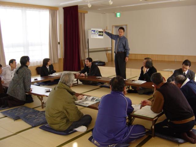
13 Government Community Workshop & Town Watching
14 Workshop & Town Watching 1 st Workshop Study about Tsunami Town Watching Find out the Dangerous Points in the Community 2 nd Workshop Make the Evacuation Map 3 rd Workshop Find out the Future Tasks
15 1 st Workshop - What is Tsunami? - Where is inundation area? - How long will it take after the Earthquake?
16

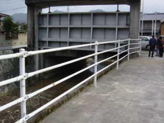
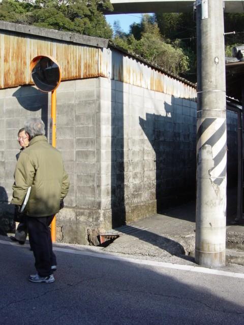
17 Town Watching Let s find out the Dangerous & Safe Points in the Community

18
19

20
21
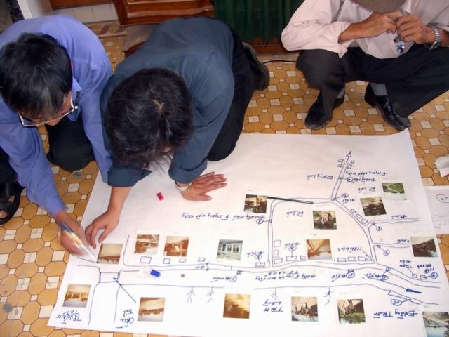
22 2 nd Workshop Let s make a map. - Where we should evacuate? - Which road is good as the evacuation route?
23
24 3 rd Workshop - We should improve the evacuate route for children and elderly people. - We should put the sign for the shelter.

25
26

27 Evacuation Map Sample

28 Evacuation Plan For Each Area


29 Evacuation PLAN Evacuation DRILL


30 Check an evacuation route Evacuation Drill A drill for revival
31 TR-RaMm Tsunami Risk - Rapid appraisal Mapping method
")
32 Photo Google Earth CENTRE NATIONAL DE L INFORMATION GEO-SPATIALE» (C.N.I.G.S)

33

34
35 First job Draw contours (black marker), put names and all details to identify the area Draw floodable area(blue area) Draw evacuation area (red marker) Estimate and write total population to be evacuated, provide demographic details(black marker) Identify Operations Center (blue sticker) Identify critical facilities, vulnerable population spots, hazardous materials storage areas (hospitals, schools, gas stations, pipelines, bridges, raceways) (red stickers), number them and describe these in writing


36 How that looks like?
37 Second job Draw contours (black marker) Define and decide on evacuation routes (green marker ) Define meeting points and shelters(green marker and blue or green sticker) Define capacity of shelters with demographic details ( men, women, childs, handicap, elders) Use Sphera to calculate needs for 48 horas usar Manual ESFERA Define signage (red and green stickers) : Green stickers=evacuation route signs, estimate time and distance to closer shelter Red sticker= floodable area, can include max high recorded (historic) or estimated


38 How that looks like?
39 Use simple color codes to restitute information Red Zone: The red zone is intended as a shore-exclusion zone that can be designated off limits in the event of any expected tsunami. This represents the highest risk zone and is the first place people should evacuate from in any sort of tsunami warning. People could expect activation of this zone several times during their life. Orange Zone: The orange zone is intended to be the area evacuated in most if not all distant- and regional-source official warnings where sufficient information is available to assess the 2 threat and the threat is assessed to extend beyond the red zone but below the yellow zone. Local differentiation of this zone can be achieved using terms that are familiar to the community such as street names and key landmarks. Activating the orange zone will prevent over-evacuation in most events. Yellow Zone: The yellow zone should cover all maximum credible tsunami, including the highest impact events. The intention is that the yellow zone provides for all source maximum credible events, based on locally determined risk. People should evacuate this zone in natural or informal warnings from a local source (i.e. in the absence of or before official warnings are issued).

40 Examples/good-not good practices


41
42 Evacuation signs Decide on sign locations as part of the evacuation mapping process It is difficult to locate signs without first laying out the evacuation zones and routes on the map Five prioritised categories of sign in the MCDEM Technical Standard: Tsunami Signage as follows:
43 Priority 1 - Evacuation zone Placed within zones to indicate a person should evacuate this zone in a warning. Contain natural warning sign information. zone boundaries can be moved as hazard understanding improves, implicit required action TSUNAMI EVACUATION ZONE TSUNAMI EVACUATION ZONE ORANGE In case of strong earthquake shaking, unusual ocean behaviour or noise, move to high ground and/or inland following evacuation routes where present Wait for official all-clear COUNCIL LOGO In case of strong earthquake shaking, unusual ocean behaviour or noise, move to high ground and/or inland following evacuation routes where present Wait for official all-clear COUNCIL LOGO


44 Priority 2 Information Boards Board including evacuation map Map as board
45 Priority 3 - Evacuation route (generic) (add white adhesive arrow) TSUNAMI EVACUATION ROUTE
46 Priority 3 Evacuation route (in place) TSUNAMI EVACUATION ROUTE Tsunami Safe Zone above third floor After earthquake or warning move above third floor
47 Priority 3 Evacuation route (vehicle, foot) TSUNAMI EVACUATION ROUTE TSUNAMI EVACUATION ROUTE
48 Priority 4 Safe location TSUNAMI SAFE LOCATION Wait for official all clear
49 Priority 5 - Previous event (must be a maximum event) ELEVATION REACHED IN 2008 CHILE TSUNAMI

50 Evacuation Zone Planning Documents

51

52 Consistent Messages


53 The image cannot be displayed. Your computer may not have enough memory to open the image, or the image may have been corrupted. Restart your computer, and then open the file again. If the red x still appears, you may have to delete the image and then insert it again. UNESCO IOC CTIC US NOAA ITIC Regional Training Workshop on Strengthening Tsunami Warning and Emergency Response Standard Operating Procedures and the Development of the ICG/CARIBE-EWS PTWC New Enhanced Products 4-8 November 2013, La Romana, Dominican Republic
Tsunami Evacuation Zones
 Tsunami Evacuation Zones Director s Guideline for Civil Defence Emergency Management Groups [DGL 08/08] Resilient New Zealand Aotearoa ManahauTsunami Evacuation Zones: Version 1.0 December 2008 1 Tsunami
National Tsunami Signage
 Technical Standard [TS01/08] National Tsunami Signage Technical Standard: National Tsunami Signage 1 National Tsunami Signage Technical Standard for the CDEM Sector [TS 01/08] April 2008 ISBN 0-478-25480-6
Surviving a tsunami is a matter of getting out of the reach of tsunami waves and inundating waters in time
 Evacuation Planning Surviving a tsunami is a matter of getting out of the reach of tsunami waves and inundating waters in time What is an Evacuation Plan? Principles of Evacuation Planning Who has to be
Tsunami Evacuation Study
 Tsunami Evacuation Study Viña del Mar Zone 2 Laura Whitehurst, Kelsey Wittels, Keshab Sharma, and José Luis Baquedano EERI Learning From Earthquakes Travel Study Program, Chile 2017 Introduction Viña del
PART 4.1 COAL HARBOUR
 PART 4.1 COAL HARBOUR 4.1.1 Overview Coal Harbour is located on Quatsino Sound which has access to the Pacific Ocean on the west coast of Vancouver Island. Population is approximately 225. Emergency Services:
A GUIDE TO TSUNAMIS FOR HOTELS. Tsunami Evacuation Procedures
 A GUIDE TO TSUNAMIS FOR HOTELS Tsunami Evacuation Procedures A Guide to Tsunamis for Hotels: Tsunami Evacuation Procedures Electronic copy of this guideline could be downloaded from http://neamtic.ioc-unesco.org
Towards an Integrated Tsunami Warning System for Port Vila and Luganville, Vanuatu
 Towards an Integrated Tsunami Warning System for Port Vila and Luganville, Vanuatu Morris J Harrison 1, Noel Steven 2 and Florence Iautu 1 1 Vanuatu Meteorology and Geo-hazards Department 2 National Disaster
Risk Analysis Tools to Support Resilient Design
 Risk Analysis Tools to Support Resilient Design 1755 Cape Ann 6.3: BC WO Paul A. Morey FEMA Region I Woods Hole, MA/NOAA Hurricane & Earthquake Program Manager Maps Commonly used by FEMA and other Federal,
The Indonesian. Toolbox
 The Indonesian Toolbox Indonesia -Ultimate in Diversity- -Tsunami- Not a question of if but WHEN 1 Major Tsunamis in Indonesia Date Origin Magnitude Max. Wave Casualties Height 19.08.1977 Sunda Islands
TSUNAMIREADY GUIDELINES
 TSUNAMIREADY GUIDELINES GUIDELINES INTRODUCTION In order for the National Weather Service (NWS) to recognize a community as TsunamiReady, the community must have implemented the activities established
Mitigation + Adaptation Strategies for Historic Structures and Sites
 Mitigation + Adaptation Strategies for Historic Structures and Sites Adrienne Burke, Esq., MSAS, LEED AP+ Executive Director, Riverside Avondale Preservation, Jacksonville, FL Cultural Resources, Disaster
What Planners Do. Heather Wade, Coastal Planning Specialist Texas Sea Grant
 What Planners Do Heather Wade, Coastal Planning Specialist Texas Sea Grant What Planners Do Seminar Series Department of Landscape Architecture and Urban Planning College of Architecture ABOUT ME B.S.
Consolidated Workshop Proceedings Report
 Consolidated Workshop Proceedings Report Regional Workshop on Urban Risk Damascus, Syria, November 4. 5. 2009 UNISDR, the Global Facility for Disaster and Recovery (GFDRR) of the World Bank, UNDP Syria
Presentation Contents
 Department of Conservation & Recreation Division of Dam Safety & Floodplain Management Rappahannock-Rapidan Regional Commission Emergency Action Planning & Other Information November 18, 2014 Presented
TSUNAMI PREPAREDNESS CHECKLIST FOR K-12 SCHOOL ADMINISTRATORS AND PRINCIPALS
 TSUNAMI PREPAREDNESS CHECKLIST FOR K-12 SCHOOL ADMINISTRATORS AND PRINCIPALS 1 A Product of EERI s School Earthquake Safety Initiative, Tsunami Safety Subcommittee Version 1.0, October 2016 Introduction
Emergency Action Plan Scripps Institution of Oceanography Region 11
 Emergency Action Plan Scripps Institution of Oceanography Region 11 This document is a detailed procedure of actions to be taken in the event of an emergency. It is to be used concurrently with the UCSD
Preetish Kakoty, Barbara Simpson, Marisella Ortega, and Wael Hassan EERI Learning From Earthquakes Travel Study Program, Chile 2017
 Tsunami Evacuation Study Viña del Mar Zone 1 Preetish Kakoty, Barbara Simpson, Marisella Ortega, and Wael Hassan EERI Learning From Earthquakes Travel Study Program, Chile 2017 ABSTRACT In the wake of
7. EMERGENCY MANAGEMENT
 7. EMERGENCY MANAGEMENT The Clallam County Emergency Management Division operates a Comprehensive Emergency Management Plan jointly with the cities of Port Angeles, Sequim, and Forks using the Incident
PEWS - Sirens. Westminster Chimes - Testing. Wailing Sounds Real Emergency. Westminster Chime
 PEWS PEWS - Sirens Located in various areas throughout the Port of Tacoma Locations provide overlapping sound radius to ensure comprehensive warning ability Westminster Chimes - Testing Wailing Sounds
WEATHER IT TOGETHER Building Resilience. The Annapolis Model for Cultural Resource Hazard Mitigation Planning
 WEATHER IT TOGETHER Building Resilience The Annapolis Model for Cultural Resource Hazard Mitigation Planning Weather It Together A Public / Private Partnership Weather It Together is the Annapolis model
Consolidated Workshop Proceedings Report
 United Nations International Strategy for Disaster Reduction Regional Office for Arab States THE WORLD BANK Syrian Ministry of Local Administration Consolidated Workshop Proceedings Report Regional Workshop
Tracking spatiotemporal patterns of building vulnerabilities and evacuations during flood hazards
 Tracking spatiotemporal patterns of building vulnerabilities and evacuations during flood hazards Shane Hubbard Junchuan Fan Kathleen Stewart Emily White The University of Wisconsin Madison, SSEC/CIMSS
PART 4.2 HYDE CREEK. Emergency Services Contact Royal Canadian Mounted Police British Columbia Ambulance Service 9-1-1
 PART 4.2 HYDE CREEK 4.2.1 Overview The Hyde Creek area is roughly bounded by Port McNeill to the west and the Nimpkish River to the east. The Spring Hill portion of the community is found just east of
Emergency Guide. Corban Office of Campus Safety Emergency Contacts & Notifications. Introduction
 & Notifications with Disabilities Emergency Guide Corban Office of Campus Safety 503-510-6430 INTRODUCTION A major emergency may occur any time of day, with little or no warning. This emergency response
BIBLIOGRAPHIC REFERENCE
 BIBLIOGRAPHIC REFERENCE Fraser, S.; Leonard, G.S.; Matsuo, I. and Murakami, H. 2012. Tsunami evacuation: Lessons from the Great East Japan earthquake and tsunami of March 11 th 2011, GNS Science Report
RESILIENCY, ADAPTATION, & SUSTAINABILITY AT THE CITY OF ST. AUGUSTINE
 RESILIENCY, ADAPTATION, & SUSTAINABILITY AT THE CITY OF ST. AUGUSTINE PROGRAM UPDATE JANUARY 14, 2019 MICHAEL G. CULLUM, P.E. DIRECTOR, PUBLIC WORKS PROGRESSION OF PLANNING FOR RESILIENCY / ADAPTATION
P C E M A. Preparedness Post. October 17th GREAT SHAKEOUT DRILL AHAB SIREN TEST EMERGENCY NOTIFICATION SYSTEM TEST
 P C E M A Pacific County Emergency Management Agency Preparedness Post Volume 2, Issue 12 October 2013 October 17th When the Lights Go Out GREAT SHAKEOUT DRILL Surfside CERT Training Sign Up for the Emergency
Sea Level Rise in the City of Vancouver: Mapping Coastal Flood Risk. Sarah North, GISP Northwest Hydraulic Consultants Ltd.
 Sea Level Rise in the City of Vancouver: Mapping Coastal Flood Risk Sarah North, GISP Northwest Hydraulic Consultants Ltd. INNER HARBOUR PORT, CONVENTION CENTRE SKYTRAIN, WEST COAST EXPRESS, FREIGHT
Design criteria for public cyclone shelters
 Design criteria for public cyclone shelters Dr Peter Mullins Mullins Consulting Brisbane TC Yasi 2nd Feb 2011 Evacuation Storm tide inundation Harvey Bay Storm Tide Model Vulnerable houses Tully TC Yasi
Preliminary Sea Level Rise Case Study: Navarre Beach, FL
 Preliminary Sea Level Rise Case Study: Navarre Beach, FL This publication was funded in part, through a grant agreement from the Florida Department of Environmental Protection, Florida Coastal Management
Early Warning Systems for. Natural Disasters in Korea
 EWC III Bonn, March 2006 Early Warning Systems for Natural Disasters in Korea Sam-Kew ROH, Ph.D. National Institute for Disaster Prevention National Emergency Management Agency Republic of Korea 2 Background
A-GIS BASED APPROACH FOR EVACUATION MODEL FOR TSUNAMI RISK REDUCTION
 A-GIS BASED APPROACH FOR EVACUATION MODEL FOR TSUNAMI RISK REDUCTION Case Study for Tsunami Evacuation Route Modelling In Cilacap-central central Java, Indonesia by Ratna Sari Dewi, Suwahyuono, Niendyawati,
Smart growth on the Oregon Coast: Addressing Impacts of climate change. What I will Cover: Oregon Land Use and OCMP Connection
 Smart growth on the Oregon Coast: Addressing Impacts of climate change Laren Woolley, Panelist Costal Shores Specialist Oregon Coastal Management Program Oregon Department of Land Conservation and Development
10. Fire services. 10 FIRE SERVICES p1
 10. Fire services Summary The New Zealand Fire Service (NZFS) is responsible for firefighting and other specialist functions including Urban Search and Rescue (USAR) during an emergency. Fire services
Sensor Placement Algorithm for Rapid Theatre Assessment (SPARTA)
") Sensor Placement Algorithm for Rapid Theatre Assessment (SPARTA) Presented by: Dr Robert Gordon and Dr Martyn Bull Introduction CB Sensors in Collective Protection Strategies Aims of Sensor Placement The
Sensor Placement Algorithm for Rapid Theatre Assessment (SPARTA) Presented by: Dr Robert Gordon and Dr Martyn Bull Introduction CB Sensors in Collective Protection Strategies Aims of Sensor Placement The
American Red Cross. Against the Wind: Protecting Your Home from Hurricane Wind Damage. Washington, D.C.: The American National Red Cross, 1994.
 Bibliography American Red Cross. Against the Wind: Protecting Your Home from Hurricane Wind Damage. Washington, D.C.: The American National Red Cross, 1994. American Red Cross. Are You Ready for an Earthquake?
Coastal Planning in Texas. Tony Williams Senior Director of Planning Coastal Resources Division Texas General Land Office
 Coastal Planning in Texas Tony Williams Senior Director of Planning Coastal Resources Division Texas General Land Office e The Texas General Land Office (GLO) and the Texas Coast Since 1836: Manager of
NORTH KINGSTOWN PILOT PROJECT May 9, 2016 North Kingstown Town Council
 Engaging RI Local Governments in Hazard Mitigation and Coastal Resilience NORTH KINGSTOWN PILOT PROJECT May 9, 2016 North Kingstown Town Council Teresa A. Crean, AICP University of Rhode Island Coastal
Local Waterfront Revitalization Programs
 Local Waterfront Revitalization Programs Jaime Ethier Coastal Resources Specialist Mid-Hudson Region Supervisor April 27, 2017 April 27, 2017 2 NYS Coastal Area Roughly 1000 feet inland from these waters
Planning Commission Report
 Planning Commission Report To: From: Subject: Planning Commission Meeting: January 6, 2016 Agenda Item: 8-B Planning Commission David Martin, Planning & Community Development Director Introduction to the
Coastal hazard assessments in Victoria
 Coastal hazard assessments in Victoria Viktor Brenners viktor.brenners@delwp.vic.gov.au Future Coasts program 4 year program established in 2007. Outputs included: Coastal Digital Elevation Models Victorian
SH1 - Causeway, Auckland, 2014 (Source: NZ Transport Agency)
") SH1 - Causeway, Auckland, 2014 (Source: NZ Transport Agency) Coastal effects assessment guide Environmental and social responsibility policy State highway environmental plan Transport Agency statement
SH1 - Causeway, Auckland, 2014 (Source: NZ Transport Agency) Coastal effects assessment guide Environmental and social responsibility policy State highway environmental plan Transport Agency statement
Coastal Climate Change Vulnerability and Flexible Adaptation Planning: the Cockburn Sound Coastal Alliance Experience
 Coastal Climate Change Vulnerability and Flexible Adaptation Planning: the Cockburn Sound Coastal Alliance Experience Presentation to Climate Change Forum by Doug Vickery Manager Infrastructure Services,
I. INTRODUCTION. identify long-term capital improvements and rehabilitation measures for the existing drainage system;
 I. INTRODUCTION The Town of Windsor, Colorado is presently experiencing rapid growth and development within the boundaries of several of its major drainage basins. As growth continues within these basins,
Empowering Local Action for Coastal Resilience in Massachusetts. Bruce K. Carlisle MA Office of Coastal Zone Management
 Empowering Local Action for Coastal Resilience in Massachusetts Bruce K. Carlisle MA Office of Coastal Zone Management Context Coastal communities continue to face both chronic and acute storm surge, erosion,
Principles for Promoting Resilient Economies. Pacific Economic Cooperation Council September 11, 2015 Sofitel Philippine Plaza, Manila
 Principles for Promoting Resilient Economies Pacific Economic Cooperation Council September 11, 2015 Sofitel Philippine Plaza, Manila Background A. Location and Topography Gateway to Region X (Northern
Fire evacuation drill
 European guideline (handbook) Fire evacuation drill (draft document) Ver: 2010-06-02 Prepared by Aleš Jug, Slovenia Related guideline: CFPA E: 19_2009 Fire safety engineering concerning evacuation from
Monterey Bay Aquarium AZA Accreditation Crisis Management-Drill Evaluation
 Monterey Bay Aquarium AZA Accreditation Crisis Management-Drill Evaluation Drill Type: Main Aquarium Evacuation. Evening Event Staff-SSA Date Conducted: 3/6/2017 Type of Drill: Live Action Notification
CHATHAM COUNTY S PATH TO SUSTAINABILITY - THE NATURAL RESOURCES SIDE
 CHATHAM COUNTY S PATH TO SUSTAINABILITY - THE NATURAL RESOURCES SIDE GEORGIA ENVIRONMENTAL CONFERENCE SAVANNAH, GEORGIA AUGUST 23, 2012 Jackie Jackson Teel Chatham County-Savannah Metropolitan Planning
Discussion objectives
 APPROACHES TO MITIGATION OF DISASTER RISK AND NEED FOR INFORMATION ON LOSS ESTIMATION N.M.S.I.ARAMBEPOLA PROGRAM MANAGER ASIAN URBAN DISASTER MITIGATION PROGRAM Discussion objectives : Explain the concept
Proposed Commercial Project at Plot No. C3A, Sector-16B, Greater Noida West (U.P)
") SAFETY AND DISASTER MANAGEMENT PLAN India has been traditionally vulnerable to natural disasters on account of its unique geo climatic conditions. Floods, droughts, cyclones, earthquakes and landslides
SAFETY AND DISASTER MANAGEMENT PLAN India has been traditionally vulnerable to natural disasters on account of its unique geo climatic conditions. Floods, droughts, cyclones, earthquakes and landslides
Louisiana Lawmakers Approve Historic Hurricane Protection Plan
 Louisiana Lawmakers Approve Historic Hurricane Protection Plan BATON ROUGE, Louisiana, June 1, 2007 (ENS) - The Louisiana Legislature has unanimously approved the state's first comprehensive master plan
State of the State New Jersey. Steve Jacobus NJDEP 06/10/15
 State of the State New Jersey Steve Jacobus NJDEP 06/10/15 1980s Living shorelines term coined in MD 2003 North Carolina passes Living Shoreline Law (HB 1028) early 2000s Delaware puts no bulkhead policy
City of Norfolk Coastal Flood Mitigation Program. March 13, 2013
 City of Norfolk Coastal Flood Mitigation Program March 13, 2013 Topics Brief overview of Norfolk s Coastal Flood Program Data-driven analysis and decision making City-wide vulnerability, project concepts,
Presented by: Theuns van der Linde
 Introducing the concept of Disaster Risk Reduction Through Environmental Design (DRRTED), and proposing a methodology for the creation of safer environments. Presentation prepared for: Conference in Disaster
EEA Capital Investment in Green Infrastructure
 EEA Capital Investment in Green Infrastructure Goal: Advance local efforts to implement measures to increase natural storm damage protection, flood control, and community resilience State capital funding
What is an Emergency?
 1 Preparing for Emergencies What is an Emergency? An emergency is a sudden unforeseen crisis, usually involving danger, which calls for immediate action. It is a situation that can directly or indirectly
An Integrated Approach for Water Management Examples from The Netherlands. Addressing Climate Change and Sea Level Rise
 An Integrated Approach for Water Management Examples from The Netherlands Addressing Climate Change and Sea Level Rise Superstorm Sandy Forum College of Staten Island March 8 2013 Water: a challenge and
Shared History, Shared Future
 Open Space is Shared History, Shared Future Builds upon past and current regional planning: PSP Action Agenda, Vision 2040, the Cascade Agenda, and Mountains to Sound Greenway The ROSS Approach Building
Getting to Resilience webinar
 Getting to Resilience webinar A brief description of two NJDEP Projects: Resilient Coastal Communities Initiative & Municipal Public Access & Resiliency Small Grants Program June 26, 2014 Marty Rosen NJ
Work Experience: Consulting Experience:
 Assistant Professor Tavida Kamolvej, Ph.D. School of Political Science, Thammasat University 2 PraJan Rd., Pranakorn, Bangkok, 10200 Thailand Tel: (662)613-2304 Fax: (662)623-5156 tkpolsc@tu.ac.th, tavida_polsc@yahoo.com
COLLABORATION & TECHNOLOGY TO IMPROVE ACTIVE SHOOTER RESPONSE
 COLLABORATION & TECHNOLOGY TO IMPROVE ACTIVE SHOOTER RESPONSE COLLABORATION & TECHNOLOGY TO IMPROVE ACTIVE SHOOTER RESPONSE Presenters Lt. Scott Parker North Precinct Commander Snohomish County Sheriff
The Conservation Of European Cities
 The Conservation Of European Cities If searching for a book The Conservation of European Cities in pdf form, then you've come to loyal website. We presented the full version of this ebook in txt, epub,
SAFETY DRILLS Lincoln County School District
 SAFETY DRILLS Lincoln County School District Lincoln County School District understands the importance of drilling students and staff on emergency procedures in order to prepare them to respond safely
The decision to evacuate or shelter-in-place (SIP) will be driven by the circumstances of a given chemical, biological or radiological emergency.
 will be driven by the circumstances of a given chemical, biological or radiological emergency.") Evacuation/Shelter In Place Decision Guide The decision to evacuate or shelter-in-place (SIP) will be driven by the circumstances of a given chemical, biological or radiological emergency. IMMEDIATE concerns
Evacuation/Shelter In Place Decision Guide The decision to evacuate or shelter-in-place (SIP) will be driven by the circumstances of a given chemical, biological or radiological emergency. IMMEDIATE concerns
R.O.M. = Rough Order of Magnitude
 3. SITE DEVELOPMENT GENERAL LOCATION The City of Corpus Christi is located on Texas coast of the Gulf of Mexico about a third of the way from the Mexican border to the Louisiana border. It is on the west
Live, Work, Locate and Site Selector
 Configuring Live, Work, Locate and Site Selector in Your Community John Hauck ArcGIS for State Government Solutions for Esri s government customers Series of useful maps and apps focused on government
EMERGENCY PROCEDURES
 EMERGENCY PROCEDURES Campus Map Campus Map REGIONAL TRAINING CENTER FACULTY PARKING HANDICAP PARKING REGIONAL TRAINING CENTER STUDENT PARKING VISITOR PARKING ACCESS ROUTES LIBRARY FACULTY PARKING HANDICAP
Warning and Notification Plan. Custer County Colorado
 Warning and Notification Plan Custer County Colorado Updated: December 2017 Record of Changes Brief Description of Change Date of Change Page(s) Affected Change Made By Format changes, added header & footer,
Indonesia: Towards Habitat III and the New Urban Agenda
 MINISTRY OF PUBLIC WORKS AND HOUSING REPUBLIC OF INDONESIA Indonesia: Towards Habitat III and the New Urban Agenda Bangkok, 27-28 January 2016 Habitat Indonesia National Secretariat Outline Towards Habitat
Personal Preparedness. Delta Police Department
 Delta Police Department Objectives To understand the importance of personal preparedness. Provide information for the creation of an emergency plan for you, your family and home. Provide information for
Incident Symbology Framework, Guideline, and Operational Implementation Guidance Version 2.0
 Produced in partnership with Ardent Management Consulting and with support from: HSHQDC-14-F-00048 Incident Symbology Framework, Guideline, and Operational Implementation Guidance Version 2.0 I. Guideline
Urban Risk and Resilience
 Urban Risk and Resilience Anshu Sharma http://picasaweb.google.com/dukebrac 1 megacity in the world in 1950; 17 in Asia Pacific alone now Upto 80% city dwellers living in sub-standard conditions Migration
The City Of West Sacramento
 The City Of West Sacramento Public Information In The Event Of A Flood Or Other Disaster The City of West Sacramento, similar to other cities throughout the country, is subject to disasters, natural or
MCPS School Safety and Security Presentation
 MCPS School Safety and Security Presentation 1 School-based Security Staffing Security assistants are assigned to every secondary school. Security team leaders are assigned to every high school and work
SOUTH AFRICA S PREPARATIONS FOR HABITAT III COMMON AFRICAN POSITION FOR HABITAT III. Habitat III Urban Breakfast 5 October 2016
 SOUTH AFRICA S PREPARATIONS FOR HABITAT III COMMON AFRICAN POSITION FOR HABITAT III Habitat III Urban Breakfast 5 October 2016 Context and Background 1. Africa intends actively shaping the New Urban Agenda,
Emergency Evacuation or Lockdown
 Emergency Evacuation and Lockdown Policy RATIONALE Emergency and evacuation situations in an education and care service can arise in a number of circumstances and for a variety of reasons. In the event
Building Blocks for Sustainable Communities Technical Assistance Flood Resilience for Riverine and Coastal Communities
 Building Blocks for Sustainable Communities Technical Assistance Flood Resilience for Riverine and Coastal Communities Silver Jackets Webinar April 2018 EPA Office of Sustainable Communities Today s Webinar
Published by the Press and Information Office, Republic of Cyprus
 The Cyprus Presidency Presentation of the artistic decoration of the Justus Lipsius Building created by the Cyprus Presidency of the Council of the European Union. Message in a logo The logo of the Cyprus
Upward Evacuation Experiment for Estimating Evacuation Speed in Water Disaster
 , pp.97-101 http://dx.doi.org/10.14257/astl.2015.100.21 Upward Evacuation Experiment for Estimating Evacuation Speed in Water Disaster Ji-Soo Lee 1, Won-Hwa Hong 2 1 Assistant Professor, Departments of
Men s Shelter SACOT Program 1210 North Tryon Street Charlotte, NC 28206
 MECKLENBURG COUNTY Community Support Services Men s Shelter SACOT Program 1210 North Tryon Street Charlotte, NC 28206 Emergency Response Guide The Safety Committee prepared this Emergency Response Guide.
Planning for Historic/Cultural Resources Coastal Resiliency in Connecticut. Presented to CAFM s 3 rd Annual Conference
 Planning for Historic/Cultural Resources Coastal Resiliency in Connecticut Presented to CAFM s 3 rd Annual Conference October 25, 2016 Agenda Introduction and Project Overview Background Historic and Cultural
Reality Check Workshop Adaptation on the ground in Istanbul. April Istanbul-Turkey
 Reality Check Workshop Adaptation on the ground in Istanbul April 2018 Istanbul-Turkey Istanbul Total Area 5.345 Km² Urban Area %26,2 Lakes %2,4 Forests %45,15 Agricultural Area %26,25 15 Million Population
SAN RAFAEL GENERAL PLAN 2040 INTRODUCTION AND OVERVIEW
 SAN RAFAEL GENERAL PLAN 2040 INTRODUCTION AND OVERVIEW Steering Committee Presentation February 14, 2018 Purpose of General Plan Guide land use and development decisions Coordinate transportation, infrastructure,
THE PROTECTION OF CHATHAM COUNTY S NATURAL RESOURCES - THE POLICY SIDE
 THE PROTECTION OF CHATHAM COUNTY S NATURAL RESOURCES - THE POLICY SIDE SEA GRANT TIDAL CREEK SUMMIT CHARLESTON, SOUTH CAROLINA DECEMBER 5, 2011 Jackie Jackson Teel Chatham County-Savannah Metropolitan
Relocation vs. Evacuation Drills Practice Makes Perfect Public Education Conference
 Relocation vs. Evacuation Drills Practice Makes Perfect 2006 Public Education Conference Safety in Our Nation s Schools Every day, some school in the country has a police, fire, or ambulance-related emergency,
Living Underwater: Hazard Mitigation Challenges from Sea Level Rise and Tidal Flooding
 ASFPM 2015 National Conference Living Underwater: Hazard Mitigation Challenges from Sea Level Rise and Darryl Hatheway, CFM, Sr. Coastal Scientist June 3, 2015 AGENDA Sea Level Rise and Science of climate
Preparing Hudson River Waterfronts for an Era of Rapid Sea Level Rise
 Preparing Hudson River Waterfronts for an Era of Rapid Sea Level Rise CITY OF KINGSTON TIDAL WATERFRONT FLOODING TASK FORCE Gregg Swanzey Director, Office of Economic Development & Strategic Partnerships,
DRR in URBAN PLANNING PROCESS in ISTANBUL
 DRR in URBAN PLANNING PROCESS in ISTANBUL Geomatic Engineer, MSc. Emin Yahya MENTEŞE Directorate of Earthquake & Ground Analysis ISTANBUL-Some facts Housing more than 15 million inhabitants Most crowded
A CONCEPTUAL PROPOSAL BY THE UMDLOTI FORUM Representing the Umdloti Ratepayers and Residents Association and the emdloti UIP
 A CONCEPTUAL PROPOSAL BY THE UMDLOTI FORUM Representing the Umdloti Ratepayers and Residents Association and the emdloti UIP PRESENTATION STRUCTURE 1.0 Overview of Umdloti 2.0 Current challenges in Umdloti
CHAPTER 1 Introduction
 CHAPTER 1 Introduction From sea to summit, Lane County covers almost 4,800 square miles of diverse Oregon landscape. Stretching from the Pacific Ocean through the Coastal Range, the Willamette Valley to
TABLE OF CONTENTS PAGE
 1989 BROWARD COUNTY LAND USE PLAN Original adoption March 1, 1989 Text amendments adopted as of March 10, 2015, are incorporated herein. BROWARD COUNTY BOARD OF COUNTY COMMISSIONERS BROWARD COUNTY PLANNING
National Park Service U.S. Department of the Interior. Climate Change Response and Cultural Landscape Preservation
 Climate Change Response and Cultural Landscape Preservation National Park Service Climate Change Response Strategy (Sept. 2010) Preserving the Nation s Heritage The preservation and protection of cultural
P C E M A. Preparedness Post. Pacific County Emergency Management Agency. Volume 5, Issue 5 July-August Burn Ban in Effect for Pacific County
 P C E M A Pacific County Emergency Management Agency Preparedness Post Volume 5, Issue 5 July-August 2016 Burn Ban in Effect for Pacific County OSU Tsunami Study on the Columbia River Thank You for Your
WEATHER IT TOGETHER. The Annapolis Model for Cultural Resource Adaptation Planning. Cultural Resources, Disaster Resilience, and Climate Uncertainty
 WEATHER IT TOGETHER The Annapolis Model for Cultural Resource Adaptation Planning Cultural Resources, Disaster Resilience, and Climate Uncertainty Historic Annapolis A Colonial Capital: National Landmark
Facing the Future: Waterfront Development Challenges in a Changing Climate
 National Working Waterfronts & Waterways Symposium Tacoma, WA March 27, 2013 Facing the Future: Waterfront Development Challenges in a Changing Climate Part 1: Ed Knight, Swinomish Indian Tribal Community
OWHC Organization of World Heritage Cities
 OWHC Organization of World Heritage Cities Safeguarding and Further Developing World Heritage Cities Position Paper Seite 1 Structure I. About the OWHC Introduction Objectives Structure Safeguarding and
SPANISH TOWN, ST. CATHERINE JAMAICA
 SPANISH TOWN, ST. CATHERINE JAMAICA This presentation is aimed at emphasizing the importance of an effective community flood alert component of Community Flood Warning Systems (CFWS) in vulnerable communities
Interdependences and the Role of Technology in Critical Infrastructure Coordination: Resilient Design Solutions
 Interdependences and the Role of Technology in Critical Infrastructure Coordination: Resilient Design Solutions Thomas G. Dallessio AICP/PP Executive Director, Next City Outgoing Director, Center for Resilient
Health & Safety Plan For Emergencies Dixon and Coal Creek Buildings
 Health & Safety Plan For Emergencies Dixon and Coal Creek Buildings November 20, 2002 Update: July 13, 2007 Update: October, 2008 Update: April, 2014 Following an emergency, only authorized Imagine! management