A-GIS BASED APPROACH FOR EVACUATION MODEL FOR TSUNAMI RISK REDUCTION
|
|
|
- Marylou Day
- 6 years ago
- Views:
Transcription

1 A-GIS BASED APPROACH FOR EVACUATION MODEL FOR TSUNAMI RISK REDUCTION Case Study for Tsunami Evacuation Route Modelling In Cilacap-central central Java, Indonesia by Ratna Sari Dewi, Suwahyuono, Niendyawati, Ari Dartoyo National Coordinating Agency for Survey and Mapping of Indonesia BAKOSURTANAL Presented in IDRIM 2010 Vienna, 1-31 September 2010
2 Outlines Introduction Objective Method Result & Discussion Conclusions

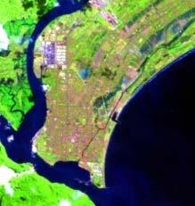
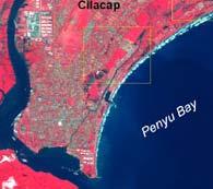
3 http//explorations.ucsd.edu Field of Study

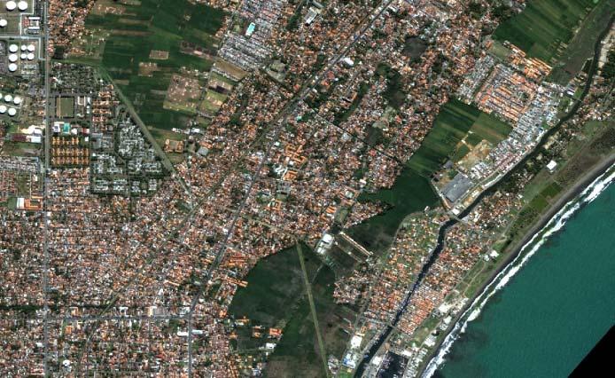
4 Introduction (1) Factories Oil company refinary Agricultural Area Sea Port Residential Areas Oil company refinary Shipping Port Why Cilacap needs an EVACUATION PLAN??? Cilacap has a flat topography Higher buildings are very limited It has many important facilities Many settlements along the coastline
5 Introduction Introduction (2) struck by tsunami t on July 17, magnitude of Earthquake > 600 people died & destruction to coastal villages and towns Need an effective evacuation plan Improvement of measure to support evacuation of residents is necessary

6 Introduction Introduction (3) Tsunami has long period, rapidly, little warning No certain building dedicated only for shelter building Finding suitable building is important High building construction cost & eficiency in space occupation Urgency
 : 1) location,")

7 Objectives To determine of potential suitable Evacuation Shelter Building (ESB) : 1) location, and 2) evacuation capacity To develop a methodology to choose the most effective evacuation routes


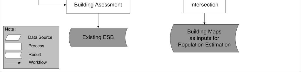
8 Introduction Method (1) The evacuation model is started from the concentration of evacuees Needed detailed data from high resolution image Building maps and road network
 (2)")
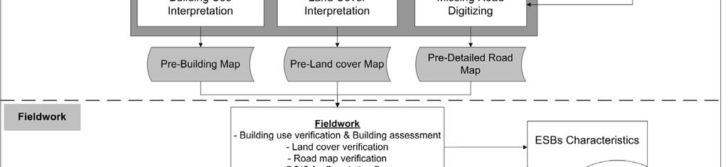
9 Method (2) Method (2)
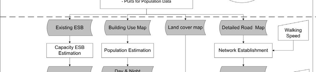
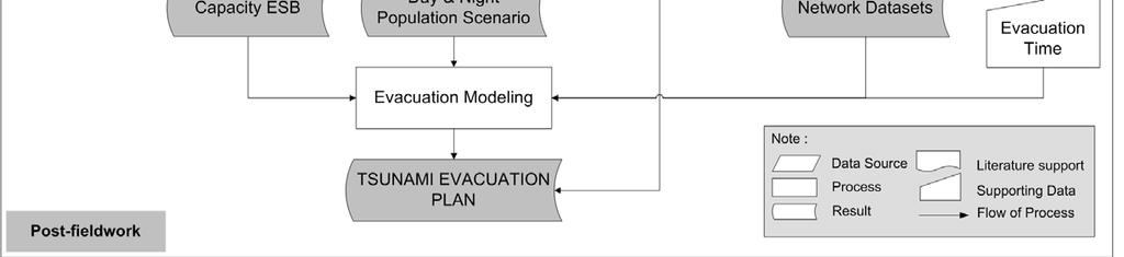
10 Research activities No Activities Data Requirement Source 1. Building Inventory Building use map QuickBird image 2. Building Assessment for ESB Potential Existing ESB Field observation 3. ESB capacity estimation Existing ESB Fieldwork, space requirement 4. Population estimation & scenario Population data BPS & Fieldwork 5. Establishing of road network datasets 6. Generating evacuation model Service area & Additional ESB Routes Road network map Center of population, ESB, Network Topographic map, QuickBird Image, Fieldwork Analysis


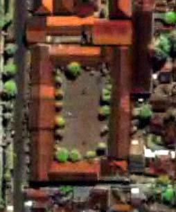
11 Results (1) Building inventory Building use map The purpose : to obtain information regarding the use of the buildings, number of occupants during daytime and nighttime population scenarios.


12 Results (2) Building Assessment for shelter building Characteristics of building design required are: Earthquake and tsunamiresistant Elevated above the wave height and parallel to the expected direction of flow Able to load a large number of people Easily accessed Potential Shelters Have an adequate stairs, or ramp to meet the building safety requirement
13 Results (3) ESB capacity estimation Build. ID Name of Building Floors Build. Area (m2) TEBC (person) 1114 SD Islam Al Azhar 2 2, SMP Islam Al Azhar 2 1, SMA Al Irsyad 3 6,460 1, STIKES 3 3,662 1, Masjid Al Islah SMP Al Irsyad 2 2, SMK Srimukti 4 2, Total 6,014


14 Results (4) Population estimation & scenario Day scenario Night scenario Total population during day time orang Total population during night time orang

15 Results (5) Network dataset Existing road data Detailed road data High resolution image and field observation were used to obtain detailed road network Speed of walking in particular road by considering impedance was applied


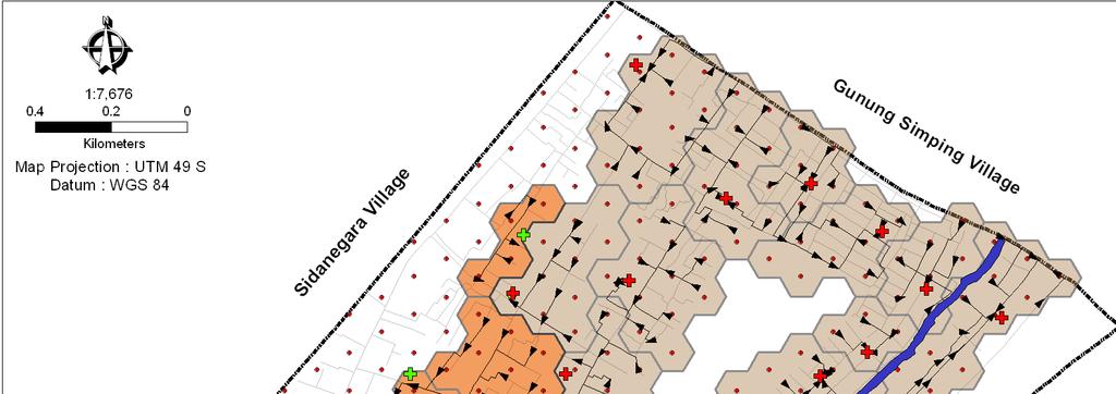
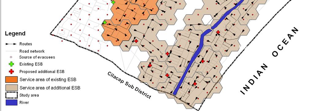
16 Results (6) Generating evacuation model Service area Additional ESB Routes Proposed additional shelter building
")
17 Results (7) Proposed evacuation route
18 Conclusion The realistic model from tsunami evacuation model is determined by the detailed input data of road network, network attributes and population data. The detailed road network will enhance the model since the travel will be carried on from the centroids of tessellations (point of origin) to the closest network. The detailed building type is necessary so that the number of evacuees could be estimated.
19 Future work This evacuation model can be improved further if congestion areas can be identified by identifying the number of evacuees that passes a certain road or travel path segment. If we can formulate the problem in optimization form, we can answer such what-if question, as the followings: What is the effect of increasing (or decreasing) the capacity of ESB? What changes when an ESB is removed or added from the network? What happened if the new roads are constructed? What will be the result of an increase (or decrease) of population?
20 Thank you for your attention
")
21 Method (4)
")
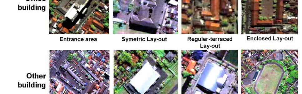

22 Method (3) Building Assessment


23 Method (3) Network Datasets Detailed road network High resolution image and field observation Speed of walking in particular road by considering impedance
24 recommendation The results have made contributions of this research, as follows: The method which was developed in this study can be adopted by local government for developing evacuation planning as part of emergency planning. The evacuation model can be used to help elevate awareness and educate both residents and local government regarding tsunami mitigation. Existing ESBs, proposed additional ESB locations and evacuation routes resulted in this study can be used as valuable information for local government and community to anticipate problems and possible solutions for tsunami disaster reduction as well.
Using Traffic Simulation for Emergency and Disaster Evacuation Planning
 Using Traffic Simulation for Emergency and Disaster Evacuation Planning Oscar Franzese National Transportation Research Center Oak Ridge National Laboratory Lee Han National Transportation Research Center
The Indonesian. Toolbox
 The Indonesian Toolbox Indonesia -Ultimate in Diversity- -Tsunami- Not a question of if but WHEN 1 Major Tsunamis in Indonesia Date Origin Magnitude Max. Wave Casualties Height 19.08.1977 Sunda Islands
Indonesia: Towards Habitat III and the New Urban Agenda
 MINISTRY OF PUBLIC WORKS AND HOUSING REPUBLIC OF INDONESIA Indonesia: Towards Habitat III and the New Urban Agenda Bangkok, 27-28 January 2016 Habitat Indonesia National Secretariat Outline Towards Habitat
Planning for Historic/Cultural Resources Coastal Resiliency in Connecticut. Presented to CAFM s 3 rd Annual Conference
 Planning for Historic/Cultural Resources Coastal Resiliency in Connecticut Presented to CAFM s 3 rd Annual Conference October 25, 2016 Agenda Introduction and Project Overview Background Historic and Cultural
Integrating fire-spread and household-level trigger modeling to stage wildfire evacuation warnings
 Integrating fire-spread and household-level trigger modeling to stage wildfire evacuation warnings Dapeng. Li 1, Thomas. J. Cova 1, Philip. E. Dennison 1 1 Department of Geography, University of Utah,
Preetish Kakoty, Barbara Simpson, Marisella Ortega, and Wael Hassan EERI Learning From Earthquakes Travel Study Program, Chile 2017
 Tsunami Evacuation Study Viña del Mar Zone 1 Preetish Kakoty, Barbara Simpson, Marisella Ortega, and Wael Hassan EERI Learning From Earthquakes Travel Study Program, Chile 2017 ABSTRACT In the wake of
Upward Evacuation Experiment for Estimating Evacuation Speed in Water Disaster
 , pp.97-101 http://dx.doi.org/10.14257/astl.2015.100.21 Upward Evacuation Experiment for Estimating Evacuation Speed in Water Disaster Ji-Soo Lee 1, Won-Hwa Hong 2 1 Assistant Professor, Departments of
A Survey of Green Remodeling
 A Survey of Green Remodeling Kevin Park Remodeling Futures Program October 21, 2008 www.jchs.harvard.edu The Existing Housing Stock is Made More Energy Efficient Through Remodeling 80 Thousand BTUs Per
CITY OF BENICIA EMERGENCY OPERATIONS PLAN 2019 UPDATE. Community Meeting February 28, 2019
 CITY OF BENICIA EMERGENCY OPERATIONS PLAN 2019 UPDATE Community Meeting February 28, 2019 Introduction & Agenda Logistics Emergency exits Restrooms Refreshments Phones Introduction Agenda Purpose Goals
San Francisco General Plan Preservation Element: Objectives 7-9. Historic Preservation Commission August 20, 2014
 San Francisco General Plan Preservation Element: Objectives 7-9 Historic Preservation Commission August 20, 2014 Preservation Element Definition An element of the General Plan that establishes a long-range
Tsunami Evacuation Zones
 Tsunami Evacuation Zones Director s Guideline for Civil Defence Emergency Management Groups [DGL 08/08] Resilient New Zealand Aotearoa ManahauTsunami Evacuation Zones: Version 1.0 December 2008 1 Tsunami
Bernardo Aliaga. Ken Gledhill. Laura Kong. Programme Specialist Tsunami Unit UNESCO/IOC ICG/CARIBE EWS Technical Secretary
 UNESCO IOC CTIC US NOAA ITIC Regional Training Workshop on Strengthening Tsunami Warning and Emergency Response Standard Operating Procedures and the Development of the ICG/CARIBE-EWS PTWC New Enhanced
Broward County Shore Protection Project Segment II. Physical Monitoring Plan
 Broward County Shore Protection Project Segment II USACE File No. SAJ-1999-05545 Broward County Shore Protection Project -Segment II Submitted To: Florida Department of Environmental Protection Office
Surviving a tsunami is a matter of getting out of the reach of tsunami waves and inundating waters in time
 Evacuation Planning Surviving a tsunami is a matter of getting out of the reach of tsunami waves and inundating waters in time What is an Evacuation Plan? Principles of Evacuation Planning Who has to be
STORMWATER FLOOD REPORT
 OREWA COASTAL RETIREMENT RESORT 25 ANNALISE PLACE OREWA for COASTAL PROPERTIES LTD STORMWATER FLOOD REPORT Job No. 1847 March 2016 Orewa Coastal Retirement Resort Page 1 of 9 CONTENTS Item Description
TRANSPORTATION ELEMENT GOALS, OBJECTIVES, AND POLICIES
 TRANSPORTATION ELEMENT GOALS, OBJECTIVES, AND POLICIES GOAL 2 The City shall provide a safe, convenient, effective, and energy efficient multimodal transportation system which is coordinated with the Future
Uchucklesaht Tribe Government Emergency Preparedness Plan
 2014 Uchucklesaht Tribe Government Emergency Preparedness Plan Uchucklesaht Tribe Government Emergency Preparedness Plan 1/1/2014 FORWARD This plan is issued under the authority of the Uchucklesaht Tribal
National Tsunami Signage
 Technical Standard [TS01/08] National Tsunami Signage Technical Standard: National Tsunami Signage 1 National Tsunami Signage Technical Standard for the CDEM Sector [TS 01/08] April 2008 ISBN 0-478-25480-6
Fire evacuation drill
 European guideline (handbook) Fire evacuation drill (draft document) Ver: 2010-06-02 Prepared by Aleš Jug, Slovenia Related guideline: CFPA E: 19_2009 Fire safety engineering concerning evacuation from
Vu Kim Chi Nguyen Thi Thuy Hang
 Vu Kim Chi Nguyen Thi Thuy Hang Tokyo, Dec 7, 2015 Introduction Data and methods Results and discussions Conclusion The city of Quy Nhon Urban planning in Quy Nhon Climate change and sea level rise Natural
7. The Landscape. 7.1 Introduction. Environmental Impact Statement (EIS) Scoping Report
 Scoping Report") 7. The Landscape 7.1 Introduction The purpose of this section of the EIS Scoping Report is to describe the scope of work and methods to be applied in the identification and assessment of landscape and
7. The Landscape 7.1 Introduction The purpose of this section of the EIS Scoping Report is to describe the scope of work and methods to be applied in the identification and assessment of landscape and
Incorpora(ng Protec(on of Cultural Heritage into Disaster Risk Management
 Incorpora(ng Protec(on of Cultural Heritage into Disaster Risk Management Rohit Jigyasu, M.Arch., Dr. of Eng. ICOMOS/ICORP - President (InternaEonal ScienEfic CommiGee on Risk Preparedness) Conserva(on
Urban Risk and Resilience
 Urban Risk and Resilience Anshu Sharma http://picasaweb.google.com/dukebrac 1 megacity in the world in 1950; 17 in Asia Pacific alone now Upto 80% city dwellers living in sub-standard conditions Migration
GREEN STORMWATER INFRASTRUCTURE (GSI) Planning Guidelines
 Planning Guidelines") GREEN STORMWATER INFRASTRUCTURE (GSI) Planning Guidelines Last Updated: June 2015 The purpose of this document is to outline the department s standard workflow for GSI planning and analysis. This packet
GREEN STORMWATER INFRASTRUCTURE (GSI) Planning Guidelines Last Updated: June 2015 The purpose of this document is to outline the department s standard workflow for GSI planning and analysis. This packet
CLARIFYING EVACUATION OPTIONS THROUGH FIRE BEHAVIOR AND TRAFFIC MODELING
 CLARIFYING EVACUATION OPTIONS THROUGH FIRE BEHAVIOR AND TRAFFIC MODELING Carol L. Rice Wildland Resource Management, Inc. carollrice@aol.com Ronny J. Coleman FireForce One Mike Price Entrada/San Juan Inc.
Glenmont III Parking Garage: Approval of Supplemental Public Hearing Staff Report and Staff Recommendations
 Planning and Development Committee Board Action Item II-A September 21, 2006 Glenmont III Parking Garage: Approval of Supplemental Public Hearing Staff Report and Staff Recommendations Washington Metropolitan
A GUIDE TO TSUNAMIS FOR HOTELS. Tsunami Evacuation Procedures
 A GUIDE TO TSUNAMIS FOR HOTELS Tsunami Evacuation Procedures A Guide to Tsunamis for Hotels: Tsunami Evacuation Procedures Electronic copy of this guideline could be downloaded from http://neamtic.ioc-unesco.org
Sea Level Rise in the City of Vancouver: Mapping Coastal Flood Risk. Sarah North, GISP Northwest Hydraulic Consultants Ltd.
 Sea Level Rise in the City of Vancouver: Mapping Coastal Flood Risk Sarah North, GISP Northwest Hydraulic Consultants Ltd. INNER HARBOUR PORT, CONVENTION CENTRE SKYTRAIN, WEST COAST EXPRESS, FREIGHT
Emergency Evacuation Team Training James Zour Life Safety Specialist Transwestern
 Emergency Evacuation Team Training James Zour Life Safety Specialist Transwestern Emergency Evacuation Plan Designed Specifically for the Building Provides an Organization Chart Outlines the Role and Responsibility
All NIGHTBRIGHT photoluminescent signs are non-electric, non-toxic and nonradioactive.
 IMPROVING BUILDINGS SAFETY THROUGH TECHNOLOGY All NIGHTBRIGHT photoluminescent signs are non-electric, non-toxic and nonradioactive. We use the latest photoluminescent technology with high-grade Strontium
COASTAL CONSERVANCY. Staff Recommendation October 21, 2010 BATTERY POINT LIGHTHOUSE ENHANCEMENTS. File No Project Manager: Deborah Hirst
 COASTAL CONSERVANCY Staff Recommendation October 21, 2010 BATTERY POINT LIGHTHOUSE ENHANCEMENTS File No. 10-025 Project Manager: Deborah Hirst RECOMMENDED ACTION: Authorization to disburse up to $100,000
PART 5 - NATURAL AND PHYSICAL ENVIRONMENT
 CONTENTS...PAGE 5.1 INTRODUCTION...3 5.2 NATURAL RESOURCES...4 5.3 PHYSICAL RESOURCES...4 5.4 COASTAL ENVIRONMENT...4 5.5 HERITAGE FEATURES...4 5.6 HAZARDS...4 5.7 SUMMARY...4 ISTHMUS SECTION - OPERATIVE
Proposed Commercial Project at Plot No. C3A, Sector-16B, Greater Noida West (U.P)
") SAFETY AND DISASTER MANAGEMENT PLAN India has been traditionally vulnerable to natural disasters on account of its unique geo climatic conditions. Floods, droughts, cyclones, earthquakes and landslides
SAFETY AND DISASTER MANAGEMENT PLAN India has been traditionally vulnerable to natural disasters on account of its unique geo climatic conditions. Floods, droughts, cyclones, earthquakes and landslides
Toward a Robust Flood Emergency Evacuation Integration of 2-D Hydraulic Modeling and Dynamic Evacuation Routing
 Toward a Robust Flood Emergency Evacuation Integration of 2-D Hydraulic Modeling and Dynamic Evacuation Routing Esri User Conference 2016 Sheng Tan, GISP June 29, 2016 Presentation Overview Study purpose
PART 4.2 HYDE CREEK. Emergency Services Contact Royal Canadian Mounted Police British Columbia Ambulance Service 9-1-1
 PART 4.2 HYDE CREEK 4.2.1 Overview The Hyde Creek area is roughly bounded by Port McNeill to the west and the Nimpkish River to the east. The Spring Hill portion of the community is found just east of
We provide exceptional solutions to help our clients achieve success.
 We provide exceptional solutions to help our clients achieve success. We began as a small, two-person surveying firm called M.E. Berry & Associates in Hollywood, Florida. Known today as Calvin, Giordano
DEPARTMENT OF ENVIRONMENTAL PROTECTION
 Chapter 382: WIND ENERGY ACT STANDARDS Summary: This chapter outlines requirements for the review of wind energy developments for impacts related to scenic character, shadow flicker, public safety, tangible
PEWS - Sirens. Westminster Chimes - Testing. Wailing Sounds Real Emergency. Westminster Chime
 PEWS PEWS - Sirens Located in various areas throughout the Port of Tacoma Locations provide overlapping sound radius to ensure comprehensive warning ability Westminster Chimes - Testing Wailing Sounds
SHORELINE, FLOOD AND COASTAL DEFENCE MANAGEMENT PLANS
 These plans may provide opportunities as well as concern for recreational boating. They are currently being revised and consulted on. This document explains how we can engage in the process. Shoreline,
EARTHQUAKE RISK MANAGEMENT IN HISTORICAL AND OLD URBAN FABRICS, CASE STUDY OF TEHRAN BAZAAR
 EARTHQUAKE RISK MANAGEMENT IN HISTORICAL AND OLD URBAN FABRICS, CASE STUDY OF TEHRAN BAZAAR Kambod AMINI HOSSEINI 1 ABSTRACT Iran as a historical country located in a seismic prone region in the world
CROWD-SOURCED REMOTE ASSESSMENTS OF REGIONAL-SCALE POST-DISASTER DAMAGE
 Eleventh U.S. National Conference on Earthquake Engineering Integrating Science, Engineering & Policy June 25-29, 2018 Los Angeles, California CROWD-SOURCED REMOTE ASSESSMENTS OF REGIONAL-SCALE POST-DISASTER
Planning for Historic/Cultural Resources Coastal Resiliency in Connecticut. Presented to ASFPM 41 st Annual Conference, Kansas City, MO
 Planning for Historic/Cultural Resources Coastal Resiliency in Connecticut Presented to ASFPM 41 st Annual Conference, Kansas City, MO May 3, 2017 Agenda Introduction and Project Overview Historic and
OUTLINE 1. INTRODUCTION
 1 2 3 4 5 6 7 8 9 1 11 12 1 2 3 4 5 6 7 8 9 1 11 12 1 2 3 4 5 6 7 8 9 1 11 12 1 2 3 4 5 6 7 8 9 1 11 12 1/21/217 FUNDAMENTAL OF LANDSCAPE ARCHITECTURE (ARL ) OUTLINE 1. INTRODUCTION WEEK 6 (INDONESIA)
Discussion objectives
 APPROACHES TO MITIGATION OF DISASTER RISK AND NEED FOR INFORMATION ON LOSS ESTIMATION N.M.S.I.ARAMBEPOLA PROGRAM MANAGER ASIAN URBAN DISASTER MITIGATION PROGRAM Discussion objectives : Explain the concept
PART 3 - RESOURCE MANAGEMENT
 CONTENTS... PAGE 3.1 INTRODUCTION... 3 3.2 NATURAL AND PHYSICAL ENVIRONMENT... 3 3.3 URBAN SUSTAINABLE MANAGEMENT... 5 3.4 RESOURCE MANAGEMENT ISSUES... 5 3.5 RESOURCE MANAGEMENT OBJECTIVES AND POLICIES...
SBCAG STAFF REPORT. MEETING DATE: March 17, 2016 AGENDA ITEM: 5I
 SBCAG STAFF REPORT SUBJECT: Cabrillo-UPRR Bridge Project MEETING DATE: March 17, 2016 AGENDA ITEM: 5I STAFF CONTACT: Fred Luna RECOMMENDATION: Authorize the chair to sign a Memorandum of Understanding
TRANSPORT AND URBAN DEVELOPMENT
 The Study on Urban Transport Master Plan and Feasibility Study in HCM Metropolitan Area (HOUTRANS) TRANSPORT AND URBAN DEVELOPMENT TDSI South & JICA Study Team 1. Objectives and Methodology of Analysis
PLANNING COMMISSION AGENDA REPORT APRIL 7, 2016
 PLANNING COMMISSION AGENDA REPORT APRIL 7, 2016 TO: FROM: Members of the Planning Commission Talyn Mirzakhanian, Senior Planner FILE NO.: 160001710 PROPOSAL: APPLICANT: RECOMMENDATION: A request for a
Coastal hazard assessments in Victoria
 Coastal hazard assessments in Victoria Viktor Brenners viktor.brenners@delwp.vic.gov.au Future Coasts program 4 year program established in 2007. Outputs included: Coastal Digital Elevation Models Victorian
EMERGENCY EVACUATION POLICY FOR 100 CHEROKEE STREET BUILDING
 EMERGENCY EVACUATION POLICY FOR 100 CHEROKEE STREET BUILDING In the event of a fire or other emergency, seconds count. The safe, orderly and prompt evacuation of building occupants depends on having the
Proposal for a nationwide interlocking regional collaboration project,
 2 0 1 3 P r o j e c t t o s t r e n g t h e n t h e b a s e o f t h e t e r r a i n ( i n t e l l e c t ), - 2 - Promotional s for the To-Collabo program Sapporo campus (Minami ward, Sapporo city) Shonan
Ridgefield and the Growth Management Act
 1 2 Ridgefield and the Growth Management Act 3 Why Do We Plan History of Planning in Ridgefield Washington experiences rapid growth in the late 1980 s that began to change the perceived quality of life.
Florida State University Libraries
 Florida State University Libraries Electronic Theses, Treatises and Dissertations The Graduate School 2015 Tsunami Evacuation: Using GIS to Integrate Behavioral and Vulnerability Data with Transportation
Lifting of evacuation orders and subsequent efforts in Japan
 Lifting of evacuation orders and subsequent efforts in Japan N. Arima Support Team for Residents Affected by Nuclear Incidents, Cabinet Office of Japan (at the time of presentation), Embassy of Japan in
RECREATION, OPEN SPACE AND GREENWAYS ELEMENT GOALS, OBJECTIVES, AND POLICIES
 RECREATION, OPEN SPACE AND GREENWAYS ELEMENT GOALS, OBJECTIVES, AND POLICIES GOAL R-1: DEVELOP A RECREATION, OPEN SPACE AND GREENWAYS SYSTEM AS AN INTEGRAL COMPONENT OF AN OVERALL, COUNTY-WIDE ECONOMIC
Relocation vs. Evacuation Drills Practice Makes Perfect Public Education Conference
 Relocation vs. Evacuation Drills Practice Makes Perfect 2006 Public Education Conference Safety in Our Nation s Schools Every day, some school in the country has a police, fire, or ambulance-related emergency,
Coastal safety- case studies in Flanders
 Coastal safety- case studies in Flanders Duinkerke, June 12th 2018 ir. Daphné Thoon MDK-Coastal Division Content 1. Introduction 2. Coastal Safety Masterplan - status 3. Management of the sandy coast 4.
If you Google Disaster Recovery, you will get approximately 47,700,000 hits.
 DISASTER RECOVERY If you Google Disaster Recovery, you will get approximately 47,700,000 hits. Disaster Planning and Prevention are the keys to Disaster Recovery. Those who forget the past are condemned
Dynamic Evacuation Guidance Considering Occupant Distribution
 Research Collection Conference Paper Dynamic Evacuation Guidance Considering Occupant Distribution Author(s): Lee, Minhyuck; Nan, Hyunwoo; Jun, Chulmin Publication Date: 2018-01-15 Permanent Link: https://doi.org/10.3929/ethz-b-000225598
XSW11, Plumstead Portal worksites, Interim Statement for NLBH. 1 Introduction Site Methodology and fieldwork objectives...4
 Contents 1 Introduction...4 2 Site Methodology and fieldwork objectives...4 2.1 NLBH Methodology... 4 2.2 NLBH Fieldwork Objectives... 5 3 Provisional Results...6 3.1 NLBH various features... 6 3.2 Shelter
Garden District Heritage Conservation District Study
 Garden District Heritage Conservation District Study Community Consultation Meeting September 24 th, 2013 What is a Heritage Conservation District? A defined area of heritage significance and character
Feasibility Study of Use of Elevators in Fire Evacuation in a High-rise Building
 5A-4 6th Asia-Oceania Symposium on Fire Science and Technology 17-20, March, 2004, Daegu, Korea Feasibility Study of Use of Elevators in Fire Evacuation in a High-rise Building A. Sekizawa 1, S. Nakahama
Coastal Climate Change Vulnerability and Flexible Adaptation Planning: the Cockburn Sound Coastal Alliance Experience
 Coastal Climate Change Vulnerability and Flexible Adaptation Planning: the Cockburn Sound Coastal Alliance Experience Presentation to Climate Change Forum by Doug Vickery Manager Infrastructure Services,
FIRE PREVENTION MANUAL CHAPTER 12, FPIB 44 May 14, 2008 EMERGENCY ACTION PLAN (EAP) NON-FIRE EMERGENCIES IN CLASS E OFFICE BUILDINGS 1.
 NON-FIRE EMERGENCIES IN CLASS E OFFICE BUILDINGS 1.") EMERGENCY ACTION PLAN (EAP) NON-FIRE EMERGENCIES IN CLASS E OFFICE BUILDINGS FIRE PREVENTION MANUAL CHAPTER 12, FPIB 44 May 14, 2008 1. INTRODUCTION 1.1 Local Law 26 of 2004 required that the Fire Commissioner
EMERGENCY ACTION PLAN (EAP) NON-FIRE EMERGENCIES IN CLASS E OFFICE BUILDINGS FIRE PREVENTION MANUAL CHAPTER 12, FPIB 44 May 14, 2008 1. INTRODUCTION 1.1 Local Law 26 of 2004 required that the Fire Commissioner
CLIMATE CHANGE & THE CARIBBEAN 3 TAKE AWAY MESSAGES
 CLIMATE CHANGE & THE CARIBBEAN 3 TAKE AWAY MESSAGES Climate Change... Distinct changes in measures of climate (rainfall, temperature, wind speed, etc.) lasting for a long period of time due to human actions.
EVACUATION PLAN FOR THE CLINTON COUNTY OFFICE BUILDING
 EVACUATION PLAN FOR THE CLINTON COUNTY OFFICE BUILDING James R. Langley, Jr. Chairman, Clinton County Legislature 2002 Table of Contents Section I: General Considerations and Planning Guidelines Introduction
A Support System for Developing Tourist Evacuation Guidance
 A Support System for Developing Tourist Evacuation Guidance Naoto Emori, Tomoko Izumi and Yoshio Nakatani Abstract This study presents the development of a computer simulator that can evaluate the effectiveness
I-66 EASTBOUND WIDENING INSIDE THE BELTWAY PARDON OUR DUST MEETING
 I-66 EASTBOUND WIDENING INSIDE THE BELTWAY From the Dulles Connector Road (Route 267) to Fairfax Drive (Route 237) PARDON OUR DUST MEETING Bill Cuttler, PE (VDOT District Construction Engineer, Northern
Energy Efficient Strategies for Urban Transportation Planning
 EinT2018 3 rd International Conference ENERGY in TRANSPORTATION 2018 Energy Efficient Strategies for Urban Transportation Planning Prof. Dr. Doaa M. El-Sherif, PhD, Arch. Email: doaa_elsherif@yahoo.com
Conservation Corridor Base and Thematic Maps
 Conservation Corridor Base and Thematic Maps August 20, 2010 This project is funded in part by the Virginia Coastal Zone Management Program at the Department of Environmental Quality through Grant #NAO9NOS4190163
Town/Village of Waterford Multi-Hazard Evacuation Plan
 Town/Village of Waterford Multi-Hazard Evacuation Plan July 2013 Prepared by: John Tanchak Public Safety Commissioner Evacuation Plan Purpose: The purpose of the Town/Village of Waterford Evacuation Plan
STAFF REPORT SAUSALITO CITY COUNCIL
 STAFF REPORT SAUSALITO CITY COUNCIL MEETING DATE: January 8, 2019 AGENDA TITLE: LEAD DEPARTMENT: Southern Marin Fire District Lessons Learned Update Report Southern Marin Fire District, Fire Chief Chris
ARLINGTON COUNTY, VIRGINIA. County Board Agenda Item Meeting of January 28, 2017 SUPPLEMENTAL REPORT-2
 ARLINGTON COUNTY, VIRGINIA County Board Agenda Item Meeting of January 28, 2017 SUPPLEMENTAL REPORT-2 DATE: January 27, 2017 SUBJECT: The Virginia Department of Transportation s Transform I-66 Inside the
UCSF Campus Floor Warden Training. Created by Herbert Cole, CEM
 UCSF Campus Floor Warden Training Created by Herbert Cole, CEM UCSF Floor Warden Program Congratulations! As a UCSF Floor Warden, you are a vital and critical member of the university s Emergency Management
SAM and ESB Update. Spring 2016 NYS Coordinator s Conference. May 18, 2016
 SAM and ESB Update Spring 2016 NYS 9-1-1 Coordinator s Conference May 18, 2016 May 18, 2016 2 Streets and Address Maintenance (SAM) Program May 18, 2016 3 SAM Address Points 6.2 million total points delivered
CONSERVATION PLAN BASED ON THE CONCEPT OF INTEGRITY
 CONSERVATION PLAN BASED ON THE CONCEPT OF INTEGRITY Y. N. Yen a C. F. Cheng a, * a China University of Technology, 56 Sec. 3 Shin Long Rd., 116 Taipei, Taiwan - (alexyen, aabbyy)@ cute.edu.tw KEY WORDS:
TSUNAMI PREPAREDNESS CHECKLIST FOR K-12 SCHOOL ADMINISTRATORS AND PRINCIPALS
 TSUNAMI PREPAREDNESS CHECKLIST FOR K-12 SCHOOL ADMINISTRATORS AND PRINCIPALS 1 A Product of EERI s School Earthquake Safety Initiative, Tsunami Safety Subcommittee Version 1.0, October 2016 Introduction
Evacuation planning is a key component of
 Transportation Security Training and Education Evacuation Planning, Human Factors, and Traffic Engineering Developing Systems for Training and Effective Response REUBEN B. G OLDBLATT AND KEVIN WEINIS CH
INCIDENT COMMAND SYSTEM. Position Manual EVACUATION GROUP SUPERVISOR- HIGH RISE INCIDENT ICS-1007
 INCIDENT COMMAND SYSTEM Position Manual EVACUATION GROUP SUPERVISOR- HIGH RISE INCIDENT July 14, 2017 This document contains information relative to the Incident Command System (ICS), developed by FIRESCOPE
EVACUATION SIMULATION FOR BUILDING DAMAGE CAUSED. Shiori KUBO Rei FUJITA Hidenori YOSHIDA Lalith WIJERATHNE Muneo HORI
 EVACUATION SIMULATION FOR BUILDING DAMAGE CAUSED Shiori KUBO Rei FUJITA Hidenori YOSHIDA Lalith WIJERATHNE Muneo HORI BACKGROUND Starting evacuation time for the people escaping from Tsunami Death by the
WHAT IS FIRE DISASTER? Fire Disaster is an occurrence or an incident of such magnitude which creates a situation in which the normal life is suddenly
 TOPIC : FIRE DISASTER MANAGEMENT PRESENTED BY :- AMALENDU BANERJEE, DIVISIONAL OFFICER, WBFES WHAT IS FIRE DISASTER? Fire Disaster is an occurrence or an incident of such magnitude which creates a situation
Appendix E Preliminary Location Hydraulic Study
 Appendix E Prepared for: State of Alaska Department of Transportation and Public Facilities Prepared by: HDR Alaska, Inc. 2525 C Street, Suite 305 Anchorage, Alaska 99503 February 2014 This page intentionally
Sandscaping in Bacton, North Norfolk
 Sandscaping in Bacton, North Norfolk Protecting critical infrastructure and benefitting communities Flood & Coast 29 March 2017 Jaap Flikweert CEng FCIWEM C.WEM Jaap.flikweert@rhdhv.com @JaapJFlikweert
Sensor Placement Algorithm for Rapid Theatre Assessment (SPARTA)
") Sensor Placement Algorithm for Rapid Theatre Assessment (SPARTA) Presented by: Dr Robert Gordon and Dr Martyn Bull Introduction CB Sensors in Collective Protection Strategies Aims of Sensor Placement The
Sensor Placement Algorithm for Rapid Theatre Assessment (SPARTA) Presented by: Dr Robert Gordon and Dr Martyn Bull Introduction CB Sensors in Collective Protection Strategies Aims of Sensor Placement The
Regional Training Workshop on Human Settlement indicators
 Regional Training Workshop on Human Settlement indicators Donatien Beguy, PhD Research and Capacity Development Branch UN-HABITAT Overview of 2030 Agenda for Sustainable Development and New Urban Agenda
SAFETY DRILLS Lincoln County School District
 SAFETY DRILLS Lincoln County School District Lincoln County School District understands the importance of drilling students and staff on emergency procedures in order to prepare them to respond safely
Legal implications of failing to
 Legal implications of failing to plan for sea level rise Gavin Leydon, Partner 30 April 2010 Outline Relevance to local l government & developers assessment & policy Developments in case law Climate change
S C O P E O F W O R K A P R I L
 white flint 2 sector plan S C O P E O F W O R K A P R I L 2 0 1 2 MONTGOMERY COUNTY PLANNING DEPARTMENT M-NCPPC MontgomeryPlanning.org 1 white flint 2 sector plan Scope of Work abstract This scope of work
Risk Assessment of Cultural Heritages Using Local Hazard Maps and Risk Filters
 October 12-17, 28, Beijing, China Risk Assessment of Heritages Using Local Hazard Maps and Risk Filters Norifumi Ikeda 1 and Fumio Nagashima 2 1 Graduate Student, Dept. of Urban System Sciences, Tokyo
of Urban and Regional Planning
 The Imperatives of Urban and Regional Planning Concepts and Case Studies from the Developing World Anis ur Rahmaan Center for Urban, Regional, Environmental and Social-Studies (CURES) Lahore, 2011 CONTENTS
ERDMP & RISK ASSESSMENT REPORT
 ERDMP & RISK ASSESSMENT REPORT Emergency Response and Disaster Management Plan (ERDMP) The scope of ERDMP is listed below (i) The identification of emergencies; (ii) The mitigation measures that attempt
EU Support Project to Freetown City Council and Urban Planning Authorities Project No. FED/2010/ The Urban Planning Project
 EU Support Project to Freetown City Council and Urban Planning Authorities Project No. FED/2010/250-190 The Urban Planning Project 2011-2014 FREETOWN STRUCTURE PLAN Presentation at Tuesday 7 th April,
Stormwater Master Plan Update. City Council Briefing January 8, 2019
 Stormwater Master Plan Update City Council Briefing January 8, 2019 1 Stormwater Master Plan Update January 8, 2019 Agenda Background for Update Stormwater Modeling and Calibration Visualizations of Results
BUSHFIRE RESPONSE PLAN
 BUSHFIRE RESPONSE PLAN February 2014 2 Document Control Revision: 1 Date: 4 February 2014 Status: Document change control: Approved by EPC Revision # Change Description Date Author 1 Initial document release
Broward County Coastal Engineering Consultant Services For Segment III Shore Protection T P1 R. Harvey Sasso, P.E. Danielle Irwin, CFM
 Coastal Systems International, Inc. Broward County Coastal Engineering Consultant Services For Segment III Shore Protection T2112588P1 R. Harvey Sasso, P.E. Danielle Irwin, CFM Experts in Coastal Engineering,
ENGINEERING CONSULTANT OFFICE FOR UTILITIES
 ENGINEERING CONSULTANT OFFICE FOR UTILITIES The Tripoli Green Belt Area Mobility Master plan has been developed over a period of 12 months, by Libyan and Italian experts team. It is designed as a strategic
Planning Commission Report
 Planning Commission Report To: From: Subject: Planning Commission Meeting: January 6, 2016 Agenda Item: 8-B Planning Commission David Martin, Planning & Community Development Director Introduction to the
presents EMERGENCY PREPAREDNESS FOR EVENT PLANNERS
 presents EMERGENCY PREPAREDNESS FOR EVENT PLANNERS Welcome Richard Aaron President, BizBash Media Keep Moving Even in a Crisis Catherine Chaulet BostonCoach Plan Ahead and the Unthinkable Becomes Manageable
National Park Service U.S. Department of the Interior. Climate Change Response and Cultural Landscape Preservation
 Climate Change Response and Cultural Landscape Preservation National Park Service Climate Change Response Strategy (Sept. 2010) Preserving the Nation s Heritage The preservation and protection of cultural
ANNEX E - EVACUATION
 ANNEX E EVACUATION PROMULGATION STATEMENT Annex E: Evacuation, and contents within, is a guide to how the University conducts a response specific to evacuation. The Annex is written in support of the Texas