ENGINEERING CONSULTANT OFFICE FOR UTILITIES
|
|
|
- Katherine Norman
- 5 years ago
- Views:
Transcription


1 ENGINEERING CONSULTANT OFFICE FOR UTILITIES


2 The Tripoli Green Belt Area Mobility Master plan has been developed over a period of 12 months, by Libyan and Italian experts team. It is designed as a strategic planning tool. Therefore it observes the context, quantifies and measures phenomena, defines targets, identifies guidelines, establishes measures, proposes solutions, and verifies results. Transport AssessmentTripoli Green Belt Systematica The effectiveness of the guidelines defined in the Master plan have been tested using the traffic model.


.")

3 Public Transport Scheme The map on the right simplifies the public transport network within the Green Belt area. The interchanges between the lines and all the stops are highlighted in a schematic way for an easier comprehension. Public Transport Network The overall potential user coverage of all the public transport lines inside the Green Belt area is around 130,000 units (almost 50% of population inside the Green Belt area is within 250 meters from a public transport stop). This simulation underlines that the efficiency of this public transport network, not only in terms of territorial coverage but also for the potential number of users.

 also in favor of the so called vulnerable road users, in order to rebalance the present situation, negatively")

4 Road network and planned junctions revision Correct junction design is the key to reduce traffic congestion and to increase the overall capacity of the network. Walking Strategy The main general aim of the strategy is the creation of an urban environment to be properly adapted and designed (or redesigned) also in favor of the so called vulnerable road users, in order to rebalance the present situation, negatively characterized by the physical and visual dominance of motorized traffic. Parking Strategy The aim of this study is to estimate future parking demand within the Green Belt area and to evaluate the required parking provision to be guaranteed at 2020, based on the assumption that 50% of the predicted trips will be made by public transport and 50% by private cars.


5 Cycling Strategy due to its topography and favorable climate, the City reveals great and interesting potentials: either for a considerable development of appropriate continuous cycling infrastructures or for a massive increase in cycling use. Taxi Strategy A city as big as Tripoli needs to conceive the transport system as a multiple mode network where also taxies can play an important role. For this reason a new taxi management is of fundamental importance for the success of the mobility master plan. Traffic Office Due to the high impact of the new traffic strategies proposed by this master plan it is of utter importance to create a Traffic Office, completely dedicated to the implementation of the new strategies and traffic regulations. The Traffic Office must have adequate


6 The overall conclusion that led the proposed road strategies in this study are: 1-Completion and upgrading of the 1 st Ring Road. 2-Downgrading of the coastal and historical centre road systems. 3-Rehabilitation of urban spaces. It has to be kept in mind that the road strategies will have to be implemented along with the other strategies proposed in this Master plan for the best case scenario.


7 LOCALISATION: The National Parks Safari Park Designer: Sep Park Design Libya it is spread over sq km, only a small part of its territory has been spared from the desert. 9/10 th of the country lay on the desert parts of the Sahara: large desert shelves with sandy ergs or rocky hamadas, flat country shelving to the Mediterranean Sea. Tripoli Safari Park s site is located 20km south of Tripoli. It is spread over 540 ha, between latitudes 32,70 and 32, 727 N and longitudes 13,16 E and 13,194.


8 Ecological Assessments This study was undertaken during the optimal period in terms of flowering. Inventories were undertaken by visiting the site by foot to gain an overview of all variety of vegetation involved and then to understand their organization within the landscape. For each variety at least one record was made to characterize the typical plant species. Most of them were localized using a GPS. Furthermore each type of vegetation identified as well as its associated species has been photographed.


9 Enhance & Preserve the Existing Natural Heritage Maintain & Increase The Ecological Diversity: Actions presented below assume three main intentions 1. Restoration of degraded areas, 2. Diversify eucalypts woodlands in terms of stratification and species, 3. Maintain good hosting conditions for the existing fauna.


10 Inform, Educate & Increase The Public Awareness The measures presented below are divided into three operational objectives: 1. Welcome the public and enable the discovery of the site with suitable accommodations. 2. Inform and increase the public awareness of Libya natural heritage richness. 3. Make a team to manage the site and the public welcoming.


11
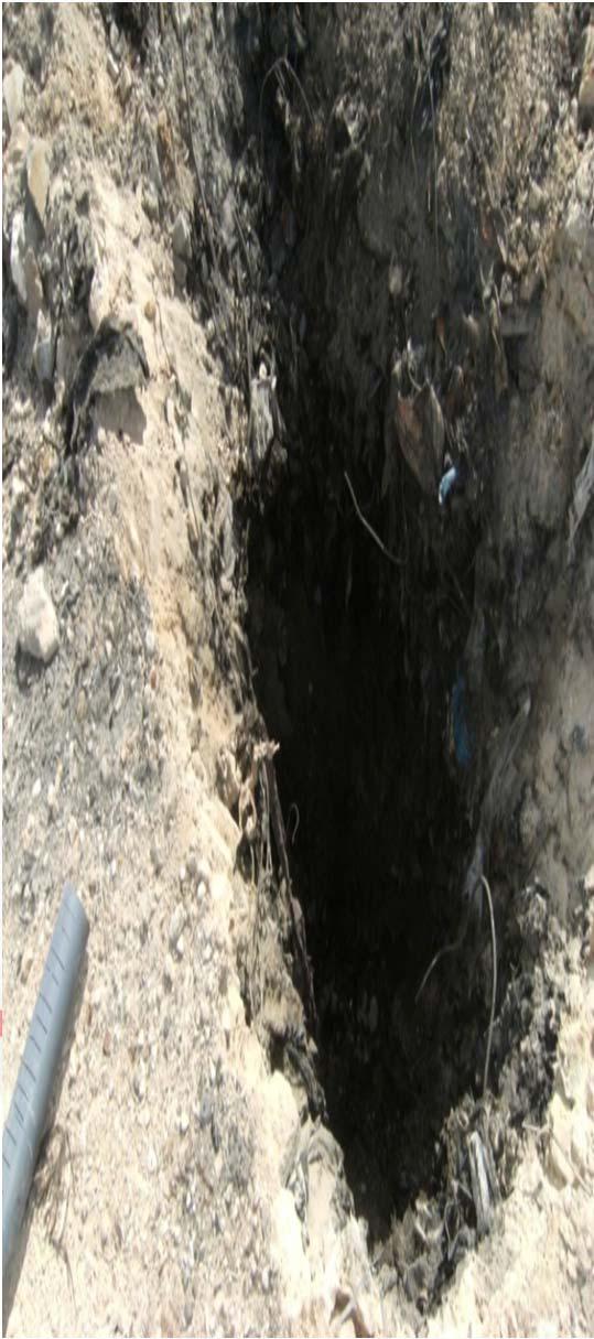
12 Re-evaluation Study for landfill in Libya The Engineering Consulting Office for Utilities ECOU carry a study for environmental assessment of four landfill sites used for solid waste in Libya, two in Tripoli, one in Sirte, and one in Benghazi.


13 Tripoli case study Ain Zara dump: is Located within the city of Tripoli with estimated area of about 19.4 hectares blocks of waste with height of 45 m from ground level. Next to the landfill site, a residential development area, with agricultural nature communities. The landfill was closed in the eighties and then reopened briefly in 2000, where it received a quantity of waste estimated around 800 tons before it is closed again completely based on a decision of the high court obtained by the local population.


14

15 Sawani dump: Is Located 7 km to the south and southwest of the city. It is surrounded by farms and residential buildings, where there are agricultural lands close to the landfill, which is irrigated by groundwater wells. There is also a power plant in the south side of the landfill as well as waste recycling plant in the south-eastern side of the landfill. Based on the future developments plans for the region, the area has been dedicated to be an industrial development zone. The landfill was closed in the late eighties or early nineties. The landfill rise blocks of waste of (20-25) meters. And the amount of waste present in the landfill is about 2.5 million cubic meters, and some of the edges of the waste are steep, where there are signs of gases and smoke rising from the edges, and this was confirmed by residents next to the landfill during the study.


16
17 Objectives of the study The main objectives of the assessment study is to obtain information regarding configuration geological area of the landfill, and the status of the contamination, and gases, and groundwater quality (if any) and the direction of flow, in addition to the properties of waste at the site and determine the changes in the landfill site since initial field survey in the water in 2008, and until you determine the types, sizes and concentrations of pollutants list and their causes.
18 Results and recommendations Based on the work of the study and risk assessment conducted in landfills, it has been found necessary to develop a strategy for how to manage the waste and waste and methods of treatment and disposal at the site. The options available for the rehabilitation of landfills confined to only three options are: 1. The total elimination of waste. 2. Site rehabilitation. 3. Leave the status quo as it is.
19 Conclusions The study to reach the following conclusions: 1- there may be a risk to public health may result from the current landfill and status. 2-The higher concentrations of certain substances in the groundwater extracted from irrigation wells surrounding the area(magnesium chloride and sodium) may be caused by evaporation rates and salinity below the surface. 3-there is a risk of slight to moderate to public health as a result to the drilling operations. 4-There is a slight risk of gas to neighboring buildings, and on-site workers to take appropriate measures to address greenhouse gas during the work period.

20 Urban development for the area of Industrial zone Tripoli, Libya The rapid growth in population and economic development Tripoli and neighboring towns to expand behind the scope area with high population density and economic activities, with the process of planning and management of growth and future development of the capital Tripoli in general, and its industry to achieve a safe and sustainable urban areas.this design prepared to outline each of the two industrial sites which are side elsyah and wadei elrabi Aziziyah, which is considered as one of the most important industrial zones planned by the central government and the local Authority to provide investment centers contain all basic facilities.


21 This project like any other projects have advantages that unique, and it has the role of integrated within the development plan for the region and the country, in general is based on: -Taking into account all industries and trades that existed in the Elflah zones, and the Suq Eltltha market to what our local market needs of industries in general. -Identify and organize activities within the site, including squares and public space and facilities, utility services and media and marketing services which constitute the cornerstone of all industrial areas in general. - This project key driver in the regeneration of jobs and assistant in solving the problems of young people and control the population distribution.


22 The detailed plan for Wadi Elrabi industrial zone

23 Some samples of the plans for the workshops in market area

24


25 Urban development for the area of Engila, Tripoli, Libya Urban development project Owner: Libyan company for creating and Urban Development The Site is located about 20 km west of the city of Tripoli. The total area for development is approximately 505 hectares. The project aims to prepare the final plan and detailed site of Engila in jafara region includes all the necessary services. focus properly on agglomeration and social environment in the region.


26 The Concept 5 residential neighborhoods and the center area. Residential densities range from R 1 to R 7 R 1: 500 m 2 Number of 1414 pieces R 2: 450 m pieces R 3: 350 m 2 Number of 2186 pieces R 6: 500 m 2 Number of 4284 pieces


27 Social Services These services were distributed in the neighborhood centers, and the central area of the development site 1 Educational: The project contains nurseries and primary schools, junior high and high schools, and the Institute of High in the center area. 2 - Health Unit has been providing primary health care in all district, and clinic grouped in the center area. 3 - use religious cultural The project contains a number four mosques in every neighborhood, with the main mosque in the center area. Site was also provided for the library and Ozkaah occasions in the center area.


28 4 - commercial use These services are distributed within neighborhoods, and the center area. 5 - open public places Distributed within neighborhoods and the center area in the form of golf kids and green areas. 6 - use administrative Distributed various administrative services in the center area.


29 Thanks for Turkish partner on good listening, and looking to build a strong partnership to rebuild Libya
30 Thank you
ROCHFORD LOCAL DEVELOPMENT FRAMEWORK: Sustainability Appraisal/ Strategic Environmental Assessment. Rochford Core Strategy Preferred Options Document
 ROCHFORD LOCAL DEVELOPMENT FRAMEWORK: Sustainability Appraisal/ Strategic Environmental Assessment Non Technical Summary Rochford Core Strategy Preferred Options Document October 2008 SUSTAINABILITY APPRAISAL
SCARBOROUGH SUBWAY EXTENSION. Scarborough Subway Extension. Final Terms of Reference
 Scarborough Subway Extension Final Terms of Reference 1 1.0 Introduction and Background 1.1 Introduction Toronto City Council recently confirmed support for an extension of the Bloor-Danforth Subway from
Energy Efficient Strategies for Urban Transportation Planning
 EinT2018 3 rd International Conference ENERGY in TRANSPORTATION 2018 Energy Efficient Strategies for Urban Transportation Planning Prof. Dr. Doaa M. El-Sherif, PhD, Arch. Email: doaa_elsherif@yahoo.com
RIGA LATVIA. KEY FEATURES OF THE CITY Demographic Facts. Urban Figures. Heritage. EXISTING GOVERNANCE MECHANISMS Development and Management Plans
 RIGA LATVIA KEY FEATURES OF THE CITY Demographic Facts around 700.000 inhabitants in the city 1.15 million people in the Riga region Urban Figures the medieval core of the Old Town the 19th century grid
Cooperative Research in Water Management
 Proceedings of the 8 th International Conference on Applied Informatics Eger, Hungary, January 27 30, 2010. Vol. 1. pp. 273 281. Cooperative Research in Water Management Margit Horosz-Gulyás, Katalin Katonáné
1Planning. Approach. Part I Chapter 1: Planning Approach
 1Planning Approach Part I Chapter 1: Planning Approach 1 Planning Approach page 5 1Planning Approach The preparation of the Master Plan constitutes a unique opportunity to reflect collectively on the
Inspiring Technovation
 1 2 Table of content List of table and figures... Executive summary... 1. Introduction... 2. Material and methods... 3. Results... 3.1 Today s facts about Versailles: a diagnostic approach... 3.1 Vision
Nominee Statement for Mr. Wang Aiguo
 Nominee Statement for Mr. Wang Aiguo Since 2010, Mr. Wang Aiguo has been working as the Director General of the Department of Irrigation, Drainage and Rural Water Supply under the Ministry of Water Resources
Welcome to the Oakridge Centre Open House
 Welcome to the Oakridge Centre Open House Why is the City hosting this event? This open house is to inform you of a rezoning application submitted to the City of Vancouver to amend the existing CD-1 (Comprehensive
Plano Tomorrow Vision and Policies
 Plano Tomorrow Vision and Policies PLANO TOMORROW PILLARS The Built Environment The Social Environment The Natural Environment The Economic Environment Land Use and Urban Design Transportation Housing
STUDY OF URBAN SMART GROWTH APPROACH BASED ON THE PRINCIPLES AND GUIDELINES FOR NEW PLANNING
 www.arpapress.com/volumes/vol23issue2/ijrras_23_2_05.pdf STUDY OF URBAN SMART GROWTH APPROACH BASED ON THE PRINCIPLES AND GUIDELINES FOR NEW PLANNING Abbas Matloubi Technical and constructive assistant,
Elodie Gonthier (Team leader) Kevin Ramirez Sandra Velasco Krishna Chandran Anna Aghvanyan Sirin Hamsho
 Kevin Ramirez Sandra Velasco Krishna Chandran Anna Aghvanyan Sirin Hamsho") 2 T he nature of today s global economy highlights our interdependence and the need for much better global policies. Inspiring Technovation is pleased to present its report on transforming the city of
2 T he nature of today s global economy highlights our interdependence and the need for much better global policies. Inspiring Technovation is pleased to present its report on transforming the city of
Rocky Areas Project Guidance HABITAT
 Rocky Areas Project Guidance HABITAT Introduction Rocky habitats are surface areas dominated by exposed rock, such as mountain peaks, inland cliffs, buttes and rocky outcrops. In many cases, rocky areas
Digital Terrestrial Television Infrastructure Rollout. Environmental Impact Assessment - Corridor -
 Digital Terrestrial Television Infrastructure Rollout Environmental Impact Assessment - Corridor - 1 1 ENVIRONMENTAL IMPACT ASSESSMENT (EIA): CORRIDOR 1.1 INTRODUCTION Corridor is a small farming community
EASTERN GOLF COURSE DEVELOPMENT PLAN OCTOBER 2013
 DEVELOPMENT PLAN OCTOBER 2013 SECTION HEADING 2 DEVELOPMENT PLAN - OCTOBER 2013 TABLE OF CONTENTS PAGE INTRODUCTION 1.1 COMPONENTS OF THE DEVELOPMENT PLAN 5 SITE ANALYSIS 2.1 OVERALL SITE CONTEXT 6 2.2
South Central Connecticut Region Plan of Conservation & Development 2018 Update. Municipal Planners
 South Central Connecticut Region Plan of Conservation & Development 2018 Update Municipal Planners July 28th, 2017 1 Introductions 2 Purpose of Today s Meeting Supplement data analysis with qualitative
MAYFIELD WEST SECONDARY PLAN PHASE 2
 MAYFIELD WEST SECONDARY PLAN PHASE 2 Public Open House #3 February 25, 2010 Draft Preferred Land Use Scenario TOWN OF CALEDON PLANNING & DEVELOPMENT DEPARTMENT Open House Agenda TOWN OF CALEDON 1. Welcome
PALMA S BEACH COMPLETE TRANSFORMATION
 TOURBANISM 6th CONFERENCE OF THE INTERNATIONAL FORUM ON URBANISM BARCELONA, JANUARY 2011. PALMA S BEACH COMPLETE TRANSFORMATION (ARCHITECTURAL, URBANISTIC AND TOURISTIC) FELIO JOSÉ BAUZÁ MARTORELL INDEX
Welcome. Walk Around. Talk to Us. Write Down Your Comments
 Welcome This is an information meeting introducing the applications for proposed redevelopment of the Yorkdale Shopping Centre site at 3401 Dufferin Street and 1 Yorkdale Road over the next 20+ years,
Newcourt Masterplan. November Exeter Local Development Framework
 Newcourt Masterplan November 2010 Exeter Local Development Framework Background The Exeter Core Strategy Proposed Submission sets out the vision, objectives and strategy for the development of Exeter up
Site Assessment Technical Document Appendix A: Glossary
 Central Bedfordshire Council www.centralbedfordshire.gov.uk Site Assessment Technical Document Appendix A: Glossary July 2017 1.1.11-1 - ii Appendix A: Glossary Term Agricultural Land Classification AONB
Watford Local Plan Part 2 Publication Stage Environmental Report. Appendix 3: Consultation Comments
 Watford Local Plan Part 2 Publication Stage Environmental Report Appendix 3: Consultation Comments August 2016 Appendix 3 - Responses to Consultation of the Local Plan Part 2 As required by the SEA Directive,
Living in Albemarle County s Urban Places
 Living in Albemarle County s Urban Places ALBEMARLE COUNTY, VIRGINIA A Closer Look at Albemarle s Approach to Managing Growth and Creating Quality Urban Environments www.albemarle.org Page 2 Living in
Rochford District Council Allocations Development Plan Document: Discussion and Consultation Document Sustainability Appraisal
 Option SWH1 Balanced Communities Option SWH1 1 To ensure the delivery of high quality sustainable communities where people want to live and work Will it ensure the phasing of infrastructure, including
Cotswolds AONB Landscape Strategy and Guidelines. June 2016
 Cotswolds AONB Landscape Strategy and Guidelines June 2016 Cotswolds AONB Landscape Strategy and Guidelines Introduction The evolution of the landscape of the Cotswolds AONB is a result of the interaction
PRESENTATION ON JOHANNESBURG S BIODIVERSITY PROGRAMME
 PRESENTATION ON JOHANNESBURG S BIODIVERSITY PROGRAMME Member of Mayoral Committee: Cllr Prema Naidoo Environmental Management & Johannesburg City Parks PRESENTATION OVERVIEW Jo burg Overview & Context
Welcome. /The Design Companion 4. /Planning London 7. /Getting Homes Built 8. /Transport & Streets 10. /Tech & The City 12
 Welcome With the draft publication of the London Plan and the Mayor s Transport Strategy (MTS) this year s events programme will examine both documents in detail with a wide range of seminars, debates
CHAPTER 8 ISSUES, CONCERNS, CONSTRAINTS AND OPPORTUNITIES
 CHAPTER 8 ISSUES, CONCERNS, CONSTRAINTS AND OPPORTUNITIES Introduction This River Conservation Plan was developed during a time of tremendous activity and effort in planning the transformation of the Delaware
ABBEY MANOR GROUP/SAINSBURY S SUPERMARKETS LTD
 ABBEY MANOR GROUP/SAINSBURY S SUPERMARKETS LTD Mixed Use Development including Business Park and Foodstore Land at Bunford Park, Bunford Lane, Yeovil Environmental Statement: Non-Technical Report June
WATERLOO STATE SIGNIFICANT PRECINCT SUMMARY OF STUDIES
 WATERLOO STATE SIGNIFICANT PRECINCT SUMMARY OF STUDIES Technical studies will be undertaken to inform the master planning process for the Waterloo precinct to develop a Precinct Proposal to redevelop the
Longbridge Town Centre Phase 2 Planning Application
 Longbridge Town Centre Phase 2 Planning Application Non-Technical Summary of the Environmental Statement December 2013 Introduction A full application for Planning Permission has been submitted to Birmingham
PSRC REVIEW REPORT & CERTIFICATION RECOMMENDATION
 PSRC REVIEW REPORT & CERTIFICATION RECOMMENDATION KITSAP COUNTY COUNTYWIDE PLANNING POLICIES July 2, 2012 BACKGROUND A major emphasis of the Washington State Growth Management Act (GMA) is the need to
Executive Summary and Introduction
 Section I Executive Summary and Introduction Introduction Purpose and Implementation Vision Themes and Strategies Description of Plan Methodology and Approach History of Comprehensive Planning Page 1 of
Sustainability Statement. Whitby Business Park Area Action Plan
 Sustainability Statement Whitby Business Park Area Action Plan November 2014 Contents Page 1. Introduction 1 2. Scoping 3 3. Sustainability Appraisal of Options 6 4. Assessment of Draft Area Action Plan
LONDON BRIDGE STATION ENVIRONMENTAL STATEMENT NON-TECHNICAL SUMMARY
 LONDON BRIDGE STATION ENVIRONMENTAL STATEMENT NON-TECHNICAL SUMMARY June 2011 1 EXECUTIVE SUMMARY 2 INTRODUCTION CONTENTS Page 2.1 Introduction 4 2.2 The Site 4 3 THE DEVELOPMENT 3.1 What is it? 5 3.2
SUMMARY. An Attractive, Competitive and Sustainable GREATER MONTREAL. Draft Metropolitan Land Use and Development Plan. April 2011
 April 2011 Draft Metropolitan Land Use and Development Plan GREATER MONTREAL An Attractive, Competitive and Sustainable SUMMARY Message from the Chair I am pleased to introduce this draft of the Metropolitan
Site ref: AS06 Site Name or Address: Murreys Court, Agates Lane
 Site ref: AS06 Site Name or Address: Murreys Court, Agates Lane Proposed Land Use: Total Site Area (Ha): Housing 1.85 Ha Description: It is understood that the owner has no plans to dispose of the site
MAYFIELD WEST SECONDARY PLAN PHASE 2
 MAYFIELD WEST SECONDARY PLAN PHASE 2 Council Information Workshop February 16, 2010 Draft Preferred Land Use Plan TOWN OF CALEDON PLANNING & DEVELOPMENT DEPARTMENT Workshop Agenda TOWN OF CALEDON 1. Welcome
Norwich (United Kingdom), 9-10 September 2004
, 9-10 September 2004") THE CONGRESS OF LOCAL AND REGIONAL AUTHORITIES Council of Europe F 67075 Strasbourg Cedex Tel : +33 (0)3 88 41 20 00 Fax : +33 (0)3 88 41 27 51/ 37 47 http://www.coe.int/cplre COLLOQUIES, SEMINARS, FORUMS
THE CONGRESS OF LOCAL AND REGIONAL AUTHORITIES Council of Europe F 67075 Strasbourg Cedex Tel : +33 (0)3 88 41 20 00 Fax : +33 (0)3 88 41 27 51/ 37 47 http://www.coe.int/cplre COLLOQUIES, SEMINARS, FORUMS
Ashtead Neighbourhood Forum Site Assessment AS07 Old Chalk Pit, Pleasure Pit Road. Site ref: AS07 Site address: Old Chalk Pit, Pleasure Pit Road
 Site ref: AS07 Site address: Old Chalk Pit, Pleasure Pit Road Proposed Land Use: Total Site Area (Ha): Housing 0.7ha Description: The site was formally an old chalk pit that has been partially filled and
GENERAL PLAN AND ENVIRONMENTAL IMPACT REPORT
 City of Menifee HEARING DRAFT GENERAL PLAN AND ENVIRONMENTAL IMPACT REPORT City Council November 2013 PURPOSE OF MEETING Overview of GP Process Overview of required and optional GP elements Receive direction
Sectoral workshop on Green infrastructure implementation. Multiple benefits of Green Infrastructure
 Sectoral workshop on Green infrastructure implementation Multiple benefits of Green Infrastructure Kristin Faurest Arad October 2015 Contents Green infrastructure as an integrated solution: social, ecological
Sustainable South Warrington s Thoughts on the Preferred Development Option put forward by Warrington Borough Council
 s Thoughts on the Preferred Development Option put forward by Warrington Borough Council Context for these thoughts was originally formed by a group of local residents and local councillors to object to
Excellencies, Dear colleagues from other agencies and organizations, Ladies and Gentlemen,
 Address by Dr Mechtild Rossler Deputy Director of UNESCO s World Heritage Centre The UNESCO Recommendation on the Historic Urban Landscape on the occasion of the European Heritage Heads Forum Leuven, Belgium,
St. Louis Park Wooddale LRT Station Site development guidelines
 St. Louis Park Wooddale LRT Station Site development guidelines November 2013 OVERVIEW St. Louis Park s convenient location as a neighbor to Minneapolis means you re only minutes away from some of the
Replacement Golf Course Facilities and Residential Development, Churston. Environmental Statement Non-Technical Summary
 Replacement Golf Course Facilities and Residential Development, Churston Environmental Statement Non-Technical Summary July 2011 Reproduced from the Ordnance Survey s map with the permission of the Controller
Port Lavaca Future Land Use
 Port Lavaca Future Land Use Introduction The City of Port Lavaca is beginning to see sustained growth, after many years of relative stable population. New single family homes, apartments, and businesses
EU Support Project to Freetown City Council and Urban Planning Authorities Project No. FED/2010/ The Urban Planning Project
 EU Support Project to Freetown City Council and Urban Planning Authorities Project No. FED/2010/250-190 The Urban Planning Project 2011-2014 FREETOWN STRUCTURE PLAN Presentation at Tuesday 7 th April,
DIAGNOSIS AND INTERVENTION ON URBAN FACADES - THE NICOSIA EXAMPLE
 RehabiMed training course: REHABILITATION OF THE URBAN LANDSCAPE 7-14 November 2005, Nicosia DIAGNOSIS AND INTERVENTION ON URBAN FAÇADES THE NICOSIA EXAMPLE Athina Papadopoulou architect-conservator Introduction-Bi-communal
Making the case for Sustainable Transport Project Potential
 Making the case for Sustainable Transport Project Potential The Structural Investment Fund (SIF) Strategy for Greater Lincolnshire identifies the barriers to growth identified by having poor transport
WELCOME GYPSY LANE. Wider Site Location plan. Proposals for the development of LAND OFF FOXLYDIATE LANE WEBHEATH. Proposals for the development of
 WELCOME The developers are preparing an outline planning application for a residential led development and need the community s views in order to develop the proposals further WHAT IS PROPOSED? A high
"Porte des Alpes" Urban Development
 GENERAL INFORMATION PETUS description of tool in use Name of the case Name of the tool Country City / region Total area (km2) Population Density (people/km2) "Porte des Alpes" Urban Development Combination
SOCIO-ECONOMIC MOVEMENT ENVIRONMENT INFRASTRUCTURE TOWN PLANNING
 Table 7: SWOT Analysis SWOT ANALYSIS SOCIO-ECONOMIC MOVEMENT ENVIRONMENT INFRASTRUCTURE TOWN PLANNING STRENGTHS HIGH COMMUTER POPULATION DENSITY MAJORITY OF POPULATION BETWEEN AGE OF 15 & 34 LARGE AVAILABLE
ASSESSING PEOPLE PERCEPTION OF SPACIOUS QUALITY INDICATORS IN OPEN SPACES.
 Title: TOWARDS JEDDAH SMART CITY: ASSESSING PEOPLE PERCEPTION OF SPACIOUS QUALITY INDICATORS IN OPEN SPACES. Presented by: Aida Nayer, Ph. D. Assistant Professor, Architecture Department, College of Architecture
Local Growth Planning in North Central Green Line Communities
 2018 April 30 Page 1 of 6 EXECUTIVE SUMMARY This report outlines a high-level scope for local growth planning for north central Green Line communities. The catalyst for this review is the significant investments
495/MetroWest Development Compact Plan Citizen Planner Training Collaborative Conference. March 17, 2012
 495/MetroWest Development Compact Plan Citizen Planner Training Collaborative Conference March 17, 2012 Project Process Local and Regional Priority Areas Growth Scenarios Transportation Investment Categories
THE CORPORATION OF THE TOWN OF OAKVILLE BY-LAW NUMBER
 THE CORPORATION OF THE TOWN OF OAKVILLE BY-LAW NUMBER 20012-08530 A by-law to adopt an amendment to the Official Plan of the Oakville Planning Area (Official Plan Amendment 198) Land North of Dundas Street.
A Global Review on Sustainable Tourism Development with Particular Reference to the UNWTO Indicators for Sustainable Tourism Development
 Hyderabad, India, 12 April 2013 A Global Review on Sustainable Tourism Development with Particular Reference to the UNWTO Indicators for Sustainable Tourism Development Dr Harold Goodwin Professor of Responsible
TEHRAN LONG TERM URBAN RAIL PLAN
 TEHRAN LONG TERM URBAN RAIL PLAN Introduction and Methodology Introduction Greater Tehran is currently one of the most populated mega cities in the world with an estimated population of 14 million inhabitants
WHITELEY TOWN COUNCIL NORTH WHITELEY DEVELOPMENT SEPTEMBER 2014
 WHITELEY TOWN COUNCIL NORTH WHITELEY DEVELOPMENT SEPTEMBER 2014 Dear Resident This Special Edition of the Whiteley Voice which has been prepared in conjunction with the North Whiteley Consortium is to
2017 STRATEGIC PLAN CITY OF ST. AUGUSTINE
 2017 STRATEGIC PLAN CITY OF ST. AUGUSTINE WHO WE ARE CITY OF ST. AUGUSTINE VISION St. Augustine will be a diverse, livable, authentic waterfront city that builds upon its rich history and environment to
A Proposal for the Development of an Eco Park in Aya Nagar, New Delhi. Greha
 A Proposal for the Development of an Eco Park in Aya Nagar, New Delhi Greha 1.0. Background 1.1. Aya Nagar is situated on the Southwestern edge of Delhi. It is the last village of Delhi on the Mehrauli
Site ref: AS11 Site Name or Address: Land South of Ermyn Way
 Site ref: AS11 Site Name or Address: Land South of Ermyn Way Proposed Land Use: Total Site Area (Ha): Residential 11.4 Ha Description: The site comprises an area to the south of Green Lane and Ermyn Way,
Strategic Environmental Assessment Screening Report. Dublin Port Masterplan Review 2017
 Strategic Environmental Assessment Screening Report Dublin Port Masterplan Review 2017 Table of Contents 1 Introduction... 1 2 Purpose of the Masterplan... 2 3 Task 1.1 Pre-Screening Check... 5 4 Task
Neighbourhood Planning Site Assessment Pro-forma and Guide Version 2
 Neighbourhood Planning Site Assessment Pro-forma and Guide Version 2 September 2014 Site HNP 006 Land East of Stanbridge Road and North of Lower Road 1. Background information Site location and use Site
WELCOME and introduction
 1 WELCOME and introduction Mobility Hub Locations within Burlington STUDY OVERVIEW STUDY OBJECTIVES The City of Burlington is developing four Area Specific Plans, one for each of Burlington s Mobility
The Town of Chrudim With Local Agendou 21 Towards Higher Quality of Life Whole City Awards
 The Town of Chrudim With Local Agendou 21 Towards Higher Quality of Life Whole City Awards Chrudim is an old town (the first written mention dates back to 1055) with a rich history and numerous cultural
It Takes A Village.. Preserving Rural Character In Standish
 It Takes A Village.. Preserving Rural Character In Standish A Public Workshop Hosted by Conservation and Open Space Plan Committee & Standish Corner Village Implementation Committee June 12, 2008 Desired
Appendix A. Planning Processes. Introduction
 1 Planning Processes Introduction This appendix outlines a number of planning processes which are used in the Auckland Region to support the effective management of development in the region s rural and
LAND USE AMENDMENT CORNERSTONE (WARD 3) COUNTRY HILLS BOULEVARD AND STONEY TRAIL NE BYLAW 9D2017
 COUNTRY HILLS BOULEVARD AND STONEY TRAIL NE BYLAW 9D2017") Page 1 of 12 EXECUTIVE SUMMARY This Land Use Amendment application covers an area of 54.92 hectares ± (135.71 acres ±) located in northeast Calgary, bound by Country Hills Boulevard NE to the north and
Page 1 of 12 EXECUTIVE SUMMARY This Land Use Amendment application covers an area of 54.92 hectares ± (135.71 acres ±) located in northeast Calgary, bound by Country Hills Boulevard NE to the north and
BUENOS AIRES: THE MICROCENTRO PLAN
 BUENOS AIRES: THE MICROCENTRO PLAN BUENOS AIRES THE MICROCENTRO PLAN Experiences and Lessons Learned _ Metropolis Meeting 2015 INCLUSION INNOVATION SUSTAINABILITY CONTENTS 1. Urban Context 2. Urban Design
1 Introduction. Chapter. In this chapter:
 Chapter 1 Introduction In this chapter: 1.1 A Snapshot of the Region 1.2 Towards a Sustainable Region 1.3 The Provincial Context 1.4 Purpose and Organization The Regional Municipality of York Official
STUDY AREA LOCATION & CONTEXT:
 UNLOCKING THE POTENTIAL OF THE KEATING CROSS ROAD BUSINESS CORRIDOR A PLAN TO CREATE + RETAIN JOB-GENERATING BUSINESSES AND TO GUIDE INFRASTRUCTURE INVESTMENT The Keating Cross Road Corridor (the Keating
SECTION ONE: INTRODUCTION. introduction
 introduction 1 INTRODUCTION Since it was first established in 1843 as a trading post for the Hudson s Bay Company, Victoria has evolved into a Provincial capital city that is recognized across Canada and
The proposals presented in September drew a large number of comments and feedback and have been grouped together as follows:
 Appendix A Stakeholder presentation + powerpoint slides Planning Context and Emerging Proposals presentation Nick Tyrrell, Alder King, Planning Consultants Alder King began by setting the site context
Active Neighbourhoods Canada SUMMARY REPORT
 Prepared by the Toronto Centre for Active Transportation JUNE 2017 Active Neighbourhoods Canada SUMMARY REPORT OF 4 ONTARIO PROJECTS Sharing participatory methods in Ontario Active Neighbourhoods Canada
Proposed new Supermarket & Petrol Station for Ludlow what do you think?
 Proposed new Supermarket & Petrol Station for Ludlow what do you think? Welcome and many thanks for coming to our consultation today. The purpose of this event is to ask for your views on our proposal
GREATER CAMBRIDGE CITY DEAL. Urban Design Guidance for Transport Infrastructure Projects
 GREATER CAMBRIDGE CITY DEAL Urban Design Guidance for Transport Infrastructure Projects KEY OBJECTIVES OF CITY DEAL The City Deal aims to help Greater Cambridge maintain and grow its status as a prosperous
STATEMENT OF OBJECTION TO THE PROPOSED DEVELOPMENT OF LAND AT CHURCH CLIFF DRIVE FILEY
 STATEMENT OF OBJECTION TO THE PROPOSED DEVELOPMENT OF LAND AT CHURCH CLIFF DRIVE FILEY You will be aware that Scarborough borough council have adopted a new local plan that includes land at Church Cliff
A VISION FOR BLAIRGOWRIE
 Welcome to the Westpark Partnership and Lidl UK GmbH Community Presentation. The purpose of this presentation is for you to view and comment upon the revised and updated proposals for the allocated development
SPG 1. * the northern and western sections which are open fields used for pasture and grazing;
 SPG 1 1.0 INTRODUCTION This development brief is based on the allocation of the Priors Hall site for employment and countryside recreational purposes in the Corby Borough Local Plan. The brief is intended
Sustainable Urban Mobility Plans. a concept to create liveable cities
 1 st European Conference on Sustainable Urban Mobility Plans Sopot, Poland, June 12&13, 2014 Sustainable Urban Mobility Plans a concept to create liveable cities Dr. Susanne Böhler-Baedeker Rupprecht Consult
Warners Bay Town Centre
 Warners Bay Town Centre Planning Workshop 1 of 2 Tuesday 6 August 2013 Opening Introduction Outline and purpose of workshops Housekeeping Group introductions Group introductions 1. People at tables to
URBAN TRANSPORT PLANNING and DECISION-MAKING for LARGE URBAN PROJECTS in TURKEY. EK Istanbul Technical University Istanbul, Turkey.
 URBAN TRANSPORT PLANNING and DECISION-MAKING for LARGE URBAN PROJECTS in TURKEY Haluk GERÇEK EK Istanbul Technical University Istanbul, Turkey. Workshop on Urban Transport in the Mediterranean Region,
Urban Development and Planning in Vienna
 Urban Development and Planning in Vienna Angelika Winkler Municipal Department for Urban Development and Planning Urban Development and Planning in Vienna April 2013 1 Vienna Key Facts and Figures federal
Taking forward the All London Green Grid
 Taking forward the All London Green Grid Foreword Earlier this year, the Mayor published the All London Green Grid Supplementary Planning Guidance to the London Plan which set the vision, and framework,
DRAFT FOR PUBLIC REVIEW. Game Plan for a Healthy City
 DRAFT FOR PUBLIC REVIEW 2018 Game Plan for a Healthy City 2 Denveright. Parks & Recreation Game Plan Draft for Public Review Draft for Public Review Executive Summary Game Plan Overview Executive Summary
Manywells, Cullingworth
 Introduction You may recall that planning permission was granted in 2010 for the redevelopment of Manywells Industrial Estate to provide a mix of employment and residential uses. Since that time, the country
Alpine Green Infrastructure Joining forces for nature, people and the economy
 Alpine Green Infrastructure Joining forces for nature, people and the economy Joint declaration of Alpine States and Regions Munich, October 2, 2017 The project is co-financed by the European Regional
Elfrida Growth Area Study
 Elfrida Growth Area Study Public Information Centre #2 December 6, 2017 6:00-8:30 pm PLANNING & ECONOMIC DEVELOPMENT DEPARTMENT Purpose of the Study The Elfrida Area has been identified as the preferred
University Park, Worcester Non Technical Summary December 2011
 University Park, Worcester Non Technical Summary December 2011 Introduction UW Wrenbridge LLP, a Joint Venture Company of the University of Worcester and Wrenbridge Land Ltd (the Applicants ) intend to
,,XIX century was the age of empires, XX century the age of states, XXI century becomes the age of cities. Wellington E. Webb, Mayor of Denver
 ,,XIX century was the age of empires, XX century the age of states, XXI century becomes the age of cities Wellington E. Webb, Mayor of Denver 1 VILNIUS : FACTS & FIGURES 16 million inhabitants in a 300
North Somerset Council Local Development Framework
 North Somerset Council Local Development Framework Sites and Policies Development Plan Document Evidence Paper Re-opening Portishead Railway Line and Options for the Location of Portishead Railway Station
This chapter describes the purpose of the Plan, introduces how the Plan is organized and provides contextual background for the Plan.
 Chapter 1: INTRODUCTION Purpose of a Comprehensive Plan The 2040 Comprehensive Plan establishes Medina s vision as a community and sets goals and objectives which guide future decisions and policies. The
elbridge Core Strategy
 C elbridge Core Strategy Celbridge is designated as a Moderate Growth Town in the RPGs. The County Development Plan reinforces this designation in its settlement strategy. Moderate Growth Towns within
Brighton Marina Neighbourhood Forum AGM. City Plan Part Two - Draft Plan
 Brighton Marina Neighbourhood Forum AGM City Plan Part Two - Draft Plan 16 May 2018 Sandra Rogers Planning Manager Carly Dockerill & Robert Davidson Principal Planning Officers Presentation outline: Context
Strategic Plan. Updated April City of St. Augustine
 Strategic Plan Updated April 2018 City of St. Augustine Our Vision St. Augustine will be a diverse, livable, authentic waterfront city that builds upon its rich history and environment to create a distinctive
Environmental Activity Nodes
 Chinese here 环保 Design Eco-Programming and Eco-Programming & Design Environmental Activity Nodes ENVIRONMENTAL EDUCATION WATER CLEANSING +URBAN DESIGN MARKETPLACE FOR LOCAL PRODUCTS Case Studies Xochimilco
BLOK BADEL ZAGREB. Competition for the urban-architectural concept design for the BADEL SITE redevelopment COMPETITION NUMBER: ZG-UA
 BLOK BADEL ZAGREB Competition for the urban-architectural concept design for the BADEL SITE redevelopment COMPETITION NUMBER: 136-12-ZG-UA 1.0 DESCRIPTION AND EXPLANATION OF THE OVERALL CONCEPT The Badel
CITY COUNCIL AGENDA REPORT
 CITY COUNCIL AGENDA REPORT Subject: COUNCIL MOTION LRT ALIGNMENT REMOVAL FROM THE TRANSPORTATION MASTER PLAN On February 10, 2016 Councillor Hughes provided notice in accordance with Section 23 of Procedure