National Audubon Society Appleton-Whittell Research Ranch Santa Cruz County, Arizona
|
|
|
- Peter Harris
- 5 years ago
- Views:
Transcription
1 Soil and Range Resource Inventory of the National Audubon Society Appleton-Whittell Research Ranch Santa Cruz County, Arizona Special Report By Donald J. Breckenfeld and Daniel Robinett Natural Resources Conservation Service April, 2001 United States Department of Agriculture, Natural Resources Conservation Service
2 National Audubon Society Appleton-Whittell Research Ranch Santa Cruz County, Arizona Foreward This inventory is an update of soil and range information and maps of the National Audubon Society Appleton-Whittell Research Ranch that is within the Soil Survey of Santa Cruz and Parts of Cochise and Pima Counties, Arizona. That survey was completed in 1971 and reflects the conditions and needs at that time. The purpose of this report is to provide updated soil and range information and maps for the Audubon Experimental Ranch. The soil information provide in this report are soil maps, soil map unit descriptions, taxonomic unit descriptions, soil map unit legend, soil and range site legend and a soil classification legend. Due to the time limitations to complete this investigation several soil series and map units were used from soil surveys from the surrounding area. Those soil series and map units used from the surrounding area soil surveys have the same soil range in characteristics and properties that were observed on the Audubon Experimental Ranch. Soil maps in this investigation and soil information may be copied without permission. Enlargements of soil maps, however, could cause misunderstanding of the detail of the map. If enlarged, distortion will occur. Enlarged maps do not show the small areas of contrasting soils that could have been shown at a larger scale. This report is advanced soil survey information and is subject to changes upon the completion, correlation and publication of an update of the Soil Survey of Santa Cruz and parts of Cochise and Pima Counties, Arizona.
3 CONTENTS Foreword Soil Legend Soil Map Unit Descriptions 10 Blacktail Hathaway - Lesliecreek complex, 1 to 45 percent slopes 20 Brunopeak very gravelly fine sandy loam, 5 to 20 percent slopes 30 Brunopeak - Hathaway complex, 5 to 45 percent slopes 40 Comoro fine sandy loam, 0 to 3 percent slopes 50 Contention very gravelly clay loam, 5 to 40 percent slopes 60 Fanno - Budlamp complex, 5 to 30 percent slopes 70 Guest clay loam, 0 to 2 percent slopes 80 Hathaway very gravelly sandy loam, 10 to 60 percent slopes 90 Lanque sandy loam, 0 to 3 percent slopes 100 Oversight sandy loam, 1 to 10 percent slopes 110 Terrarosa complex, 1 to 10 percent slopes 120 Terrarosa - Blacktail Pyeatt complex, 1 to 45 percent slopes Soil Classification Legend Soil Series and their Morphology Blacktail Brunopeak Budlamp Comoro Contention Fanno Guest Hathaway Lanque Lesliecreek Oversight Pyeatt Terrarosa Ecological Site Legend Ecological Site Map Legend and Map by Brian Loomis Summary of Ecological Sites Plant List from NRCS Ecological Site and Soils Inventory Glossary Appendix A (Not included on Web at this time. Contact Researchranch@audubon.org) NRCS Ecological Site Descriptions NRCS MLRA Map Appendix B (Not included on Web at this time. Contact Researchranch@audubon.org) NRCS Ecological Site Inventory NRCS Range Health Inventory Land Status Map Ranch Map
4 National Audubon Society Appleton-Whittell Research Ranch Soil Legend 10 Blacktail Hathaway - Lesiecreek complex, 1 to 45 percent slopes 20 Brunopeak very gravelly fine sandy loam, 5 to 20 percent slopes 30 Brunopeak - Hathaway complex, 5 to 45 percent slopes 40 Comoro fine sandy loam, 0 to 3 percent slopes 50 Contention very gravelly clay loam, 5 to 40 percent slopes 60 Fanno - Budlamp complex, 5 to 30 percent slopes 70 Guest clay loam, 0 to 2 percent slopes 80 Hathaway very gravelly sandy loam, 10 to 60 percent slopes 90 Lanque sandy loam, 0 to 3 percent slopes 100 Oversight sandy loam, 1 to 10 percent slopes 110 Terrarosa complex, 1 to 10 percent slopes 120 Terrarosa - Blacktail Pyeatt complex, 1 to 45 percent slopes
5 Soil Map Unit Descriptions
6 10 Blacktail Hathaway - Lesliecreek complex, 1 to 45 percent slopes Setting Landform: fan terraces Slope range: Blacktail, 1 to 25 percent; Hathaway, 1 to 45 percent; Lesiliecreek, 1 to 3 percent Hazard of flooding: Lesliecreek none to rare Elevation: 4,700 to 5,100 feet Mean annual precipitation: 16 to 20 inches Mean annual air temperature: 57 to 62 degrees F. Frost-free period: 160 to 210 days Composition Blacktail and similar soils: 45 percent Hathaway and similar soils: 40 percent Lesiescreek and similar soils: 10 percent Contrasting inclusions: 5 percent Typical Profile Blacktail 0 to 3 inches - dark brown gravelly loam 3 to 7 inches - dark reddish brown clay loam 7 to 17 inches - dark reddish brown clay 17 to 23 inches - brown, calcareous, clay loam 23 to 32 inches - pinkish white, calcareous, sandy loam 32 to 60 inches - pink and light brown, calcareous, gravelly sandy loam Hathaway 0 to 8 inches - dark grayish brown gravelly loam 8 to 24 inches pale brown, calcareous, gravelly loam 24 to 60 inches light gray and light eddish brown, calcareous, very gravelly loamy sand and sand Lesliecreek 0 to 5 inches - brown fine sandy loam 5 to 25 inches - brown sandy clay loam 25 to 60 inches - brown gravelly sandy clay loam Soil Properties and Qualities Blacktail Parent material: mixed fan alluvium Depth class: very deep Drainage class: well drained Permeability: slow Available water capacity: moderate to high Potential rooting depth: 60 inches or more Runoff: low to very high Hazard of erosion by water - slight to severe by wind - slight Shrink-swell potential: high Rock fragments: less than 35 percent, but can range up to 50 percent Depth to calcic horizon: 15 to 30 inches Calcium carbonate equivalent: 1 to 60 percent Corrosivity: steel - moderate; concrete moderate Hathaway Parent material: mixed calcareous fan alluvium Depth class: very deep Drainage class: well drained Permeability: moderate to moderately rapid Available water capacity: low Potential rooting depth: 60 inches or more Runoff: medium to rapid Hazard of erosion by water - slight to severe by wind - slight Shrink - swell potential: low Rock fragments: greater than 35 percent Depth to calcic horizon: 5 to 20 inches Calcium carbonate equivalent: 5 to 40 percent Corrosivity: steel - moderate; concrete - low Lesliecreek Parent material: mixed alluvium Depth class: very deep Drainage class: well drained Permeability: moderately slow Available water capacity: high Potential rooting depth: 60 inches or more Runoff: low to medium Hazard of erosion by water - slight to moderate by wind - slight Shrink-swell potential: moderate Corrosivity: steel - high; concrete - low
7 Inclusions Contrasting inclusions : Fanno and Budlamp soils that are shallow to moderately deep to bedrock : Brunopeak soils that have greater than 35 rock fragments Similar inclusions : Terrarosa soils : Soils that are not calcareous in the drainageways : Pyeatt soils that have less than 35 percent rock fragment and ccumulations of calcium carbonate Use and Management Major current uses: wildlife habitat Soil related factors Blacktail - slow permeability, high-shrink swell potential, clayey texture, slope Hathaway - slope, hazard of water rosion Lesliecreek - hazard of water erosion, flooding Dominant vegetation on the Blacktail soils : in potential plant community - plains lovegrass, sideoats grama, Texas bluestem, cane beardgrass, false mesquite, velvetpod mimosa, crinkleawn, beggartick threeawn, sotol, agave, Emory oak, Mexican blue oak, Arizona white oak, green sprangletop, yerba-de-pasmo : in present plant community - plains lovegrass, sideoats grama, Texas bluestem, cane beardgrass, false mesquite, velvetpod mimosa, crinkleawn, beggartick threeawn, sotol, agave, Emory oak, Mexican blue oak,arizona white oak Dominant vegetation on the Pyeatt soil : in potential plant community - sideoats grama, false mesquite, black grama, New Mexico feathergrass, rough tridens, shortleaf tridens, range ratany, agave, sotol, sacahuista, blue threeawn, crinkleawn : in present plant community - sideoats grama, sotol, black grama, New Mexico feathergrass, rough tridens, shortleaf tridens, ratany, agave Dominant vegetation on the Lesliecreek soil : in potential and present plant community - Arizona cottontop, sideoats grama, green sprangletop, cane beardgrass, vine mesquite Special Management Concerns : This site responds well to managed natural and prescribed fires. : The high content of clay in the Blacktail soil will slow infiltration and permeability. : Consider the high shrink-swell potential when designing and building foundations, concrete structures, and paved areas. : These soils have a moderate to severe water erosion potential; therefore, special considerations should be given to water management in this area. : Steep slopes are a management concern. Interpretative Groups Land capability classification Blacktail and Hathaway Slopes 1 to 30 percent - VIs nonirrigated Slopes 30 to 45 percent - VIe nonirrigated Lesliecreek - VIw nonirrigated Ecological site Blacktail - Loamy Hills p.z. 041XA107AZ Hathaway - Limy Slopes p.z. 041XA104AZ Lesliecreek Loamy bottom, swales p.z. 041XC311AZ Major land resource area: 41 -Southeastern Arizona Basin and Range Land resource unit: 41-1AZ - Mexican Oak Pine Woodland and Oak Savannah
8 20 Brunopeak very gravelly fine sandy loam, 5 to 20 percent slopes Setting Landform: fan terraces Elevation: 4,700 to 5,100 feet Mean annual precipitation: 16 to 20 inches Mean annual air temperature: 57 to 62 degrees F. Frost-free period: 160 to 210 days Composition Brunopeak and similar soils: 90 percent Contrasting inclusions: 10 percent Typical Profile Brunopeak 0 to 1 inch - brown very gravelly sandy fine loam 1 to 5 inches - reddish brown gravelly sandy clay loam 5 to 26 inches - reddish brown very gravelly clay 26 to 60 inches - reddish brown very gravelly sandy clay loam Soil Properties and Qualities Brunopeak Parent material: mixed fan alluvium Depth class: very deep Drainage class: well drained Permeability: slow Available water capacity: low Potential rooting depth: 60 inches or more Runoff: high to very high Hazard of erosion by water slight to moderate by wind - slight Shrink-swell potential: high Rock fragments: greater than 35 percent gravel and cobbles Corrosivity: steel - high; concrete moderate Inclusions Contrasting inclusions : Terrarossa soils that have less than 35 percent rock fragments in the control section : Soils that are very shallow and shallow to fanglomerate Similar inclusions : Blacktail soils that are calcareous at moderate depths Use and Management Major current uses: wildlife habitat Soil related factors: slow permeability, high shrink-swell potential, content of rock fragments, clayey texture, hazard of water erosion, slope Dominant vegetation: : in potential and present plant community plains lovegrass, sideoats grama, Texas bluestem, cane beardgrass, blue grama, palmer agave, oak, juniper, tanglehead, green sprangletop, wait-a-bit mimosa, velvet pod mimosa, false mesquite Special Management Concerns : The high content of clay in Brunopeak soil slows infiltration and permeability. : The high shrink-swell potential of the brunopeak soil should be considered when designing and building foundations, concrete structures, and paved areas. : These soil has a moderate water erosion potential; therefore, special considerations should be given to water management in this area. : Excessive rock fragments in the soil interferes with excavations. : Steep slopes are a management concern Interpretive Groups Land capability classification Slopes 10 to 20 percent - VIs nonirrigated Ecological site Brunopeak - - Loamy Upland p.z. 041XA108AZ Major land resource area: 41 - outheastern Arizona Basin and Range Land resource unit: 41-1AZ - Mexican Oak Pine Woodland and Oak Savannah
9 30 Brunopeak - Hathaway complex, 5 to 45 percent slopes Setting Landform: fan terraces; Brunopeak and Hathaway are on the side slopes of the fan terraces Slope range: Brunopeak, 5 to 25 percent; Hathaway, 5 to 45 percent slopes Elevation: 4,700 to 5,100 feet Mean annual precipitation: 16 to 20 inches Mean annual air temperature: 57 to 62 degrees F. Frost-free period: 160 to 210 days Composition Brunopeak and similar soils: 60 percent Hathaway and similar soils: 30 percent Contrasting inclusions: 10 percent Typical Profile Brunopeak 0 to 1 inch - brown very gravelly sandy fine loam 1 to 5 inches - reddish brown gravelly sandy clay loam 5 to 26 inches - reddish brown very gravelly clay 26 to 60 inches - reddish brown very gravelly sandy clay loam Hathaway 0 to 8 inches - dark grayish brown gravelly loam 8 to 24 inches pale brown, calcareous, gravelly loam 24 to 60 inches light gray and light reddish brown, calcareous, very gravelly loamy sand and sand Soil Properties and Qualities Brunopeak Parent material: mixed fan alluvium Depth class: very deep Drainage class: well drained Permeability: slow Available water capacity: low Potential rooting depth: 60 inches or more Runoff: high to very high Hazard of erosion by water - moderate to severe by wind - slight Shrink-swell potential: high Rock fragments: greater than 35 percent gravel and cobbles Corrosivity: steel - high; concrete moderate Hathaway Parent material: mixed calcareous fan alluvium Depth class: very deep Drainage class: well drained Permeability: moderate to moderately rapid Available water capacity: low Potential rooting depth: 60 inches or more Runoff: medium to rapid Hazard of erosion by water - slight to severe by wind - slight Shrink-swell potential: low Rock fragments: greater than 35 percent Depth to calcic horizon: 5 to 20 inches, Calcium carbonate equivalent: 5 to 40 percent Corrosivity: steel - high; concrete - low Inclusions Contrasting inclusions : Soils that contain less than 18 percent clay in the drainageways : Terrarossa soils that have less than 35 percent rock fragments in the control section : Soils that are very shallow and shallow to fanglomerate Similar inclusions : Pyeatt soils that have less than 35 percent rock fragments and are very deep : Blacktail soils that are calcareous at moderate depths Use and Management Major current uses: wildlife habitat Soil related factors: Brunopeak - slow permeability, high shrink-swell potential, content of rock fragments, clayey texture, hazard of water erosion, slope Hathaway - hazard of water erosion, high content of calcium carbonate, slope
10 Dominant vegetation on the Brunopeak soil : in potential and present plant community plains lovegrass, sideoats grama, Texas bluestem, green sprangletop, cane beardgrass, blue grama, palmer agave, oak, juniper, tangletop, wait-a-bit mimosa, velvet pod mimosa, false mesquite Pine Woodland and Oak Savannah Dominant vegetation on the Hathaway soil : in potential and present plant community black grama, sideoats grama, crinkleawn, wooly bunchgrass, blue threeawn, hairy grama, New Mexico feathergrass, slim tridens, shortleaf tridens, sacahuista, false mesquite, Gregg s dalea Special Management Concerns : The high content of clay in the Brunopeak soil slows infiltration and permeability. : The high shrink-swell potential of the brunopeak soil should be considered when designing and building foundations, concrete structures, and paved areas. : These soils have a severe water erosion potential; therefore, special onsiderations should be given to water management in this area. : Excessive rock fragments in the soil interferes with excavations. : Steep slopes are a management concern Interpretive Groups Land capability classification Slopes 10 to 30 percent - VIs nonirrigated Slopes 30 to 45 percent - VIe nonirrigated Ecological site Brunopeak - Loamy Hills p.z. 041XA107AZ Hathaway - Limy Slopes p.z. 041XA104AZ Major land resource area: 41 - Southeastern Arizona Basin and Range Land resource unit: 41-1AZ - Mexican Oak
11 40 Comoro fine sandy loam, 0 to 3 percent slopes Setting Landform: floodplains, alluvial fans and inset fans Hazard of flooding: rare Elevation: 4,700 to 5,100 feet Mean annual precipitation: 12 to 16 inches Mean annual air temperature: 60 to 67 degrees F. Frost-free period: 180 to 230 days Composition Comoro and similar soils: 85 percent Contrasting inclusions: 15 percent Typical Profile Comoro 0 to 2 inches - brown fine sandy loam 2 to 25 inches - brown sandy loam 25 to 36 inches - very dark grayish brown fine sandy loam 36 to 40 inches - brown sandy loam Soil Properties and Qualities Comoro Parent material: mixed alluvium Depth class: very deep Drainage class: well drained Permeability: moderately rapid Available water capacity: moderate Potential rooting depth: 60 inches or more Runoff: medium Hazard of erosion by water - slight by wind moderately high Shrink-swell potential: low Rock fragments: averages less than 35 percent Corrosivity: steel - high; concrete - low Inclusions Contrasting inclusions : Guest soils that have more than 35 percent clay : Soils that have sandy or gravelly sand textures : Soils that have a seasonal water table at moderate to deep depths : Riverwash Similar inclusions : Soils that are not calcareous throughout : Comoro soils that have sandy clay loam textures at moderate depths : Soils that have gravelly subsoils : Soils that have light colored loamy sand to sand surface textures Use and Management Major current uses: wildlife habitat Soil related factors: hazard of seepage, hazard of flooding, hazard of wind erosion Dominant vegetation: : in potential and present plant community Giant sacaton, sideoats grama, green sprangletop, desert willow, Arizona black walnut Special Management Concerns : These soils have moderately high to high wind erosion potential. Care should be taken when vegetation is removed from this site to prevent dust and soil loss. : This is an important wildlife site; therefore, special consideration in conservation planning should be given to maintaining wildlife habitat and water. : Structures should be located above the expected flood level. : Water moving across this site may cause piping. Interpretive Groups Land capability classification VIw nonirrigated Ecological site Comoro Loamy bottom, subirrigated 12 to 16 p.z. 041XC312AZ Major land resource area: 41 - Southeastern Arizona Basin and Range Land resource unit: 41-3AZ Southern Arizona Semidesert Grassland
12 50 Contention gravelly silt loam, 5 to 60 percent slopes Setting Landform: dissected relict lake beds Elevation: 4,700 to 4,900 feet Hazard of flooding: none Mean annual precipitation: 16 to 20 inches Mean annual air temperature: 57 to 62 degrees F. Frost-free period: 160 to 210 days Composition Contention and similar soils: 90 percent Inclusions: 10 percent Typical Profile Surface coarse fragments: 10 to 20 percent gravel 0 to 1 inches brown very gravelly clay loam 1 to 17 inches brown clay 17 to 45 inches - brown, gypsiferous, clay Soil Qualities and Potentials Parent material: mixed alluvium from prehistoric lakes and marshes Depth class: very deep Drainage class: well Permeability: very slow Available water capacity: moderate Potential rooting depth: 60 inches or more Runoff: medium to very rapid Hazard of erosion: by water moderate to very severe by wind - slight Shrink-swell potential: high Soil cracks: When dry, continuous cracks from the surface to a depth 30 or more inches, ranging from.12 to 1.50 inches in width Calcium carbonate equivalent: 1 to 15 percent Depth to gypsic horizons: 12 to 20 inches Gypsum content:.5 to 15 percent Corrosivity: steel - high concrete - high Inclusions Contrasting inclusions : Soils that contain very dense layers : Soils that contain less gypsum : Shallow to moderately deep, sandy loam soils that cap Contention soils Similar inclusions : Contention soils that have less surface gravel Use and Management Major current uses: wildlife habitat Soil related factors: Contention - hazard of water and wind erosion, piping, soil settling, slow permeability, high shrink-swell, cracking, excess gypsum, and clayey texture Dominant vegetation: : in potential and present plant community tobosa, curly mesquite, false mesquite, sideoats grama. Special Management Concerns : Gypsum soils can induce electrochemical action that increases the corrosivity rate on concrete. : Concentrated runoff in drainage ditches can dissolve gypsum in the subsoil layers and cause settling. : Soil high in gypsum is susceptible to piping, settling and erosion. : This soil has moderate to severe water erosion potential where piping and gullies occur near deep, unstable stream channels. Therefore special considerations should be given to water management in regards to runoff, diversion, and irrigation.
13 : This soil has severe limitations for foundations for buildings due to steep slopes, poor bearing strength and high shrink-swell potential. : This soil is unsuitable for sanitary landfills and septic tank filter fields due to steep slopes. Steep slopes limit the distribution of effluent, and may cause it to surface at points down slope. Special Management Measures : For new construction, surface water should be diverted away from building foundations by building the foundation on slightly elevated fill material and grading away from the foundation. : To reduce the effects of piping and settling, moisture should be diverted from building foundations by rain gutters and downspouts and irrigating the shrubbery around the building no more than needed to sustain growth. Plant shrubbery as far from the foundation as possible or do not plant shrubbery next to the foundation. : The effects of shrink-swell potential can be minimized by using proper engineering designs, backfilling with material that has low shrink-swell potential, and diverting runoff moisture away from the foundation helping to prevent structural damage. : To compensate for slow permeability which limits septic tank absorption fields, the use of sand and gravel backfill for the trench and increasing the size of the absorption field. : The steepness of the slope is a concern installing septic tank absorption fields. Absorption lines should be installed on the contour. Interpretive Group Land capability Classification Contention - VIIe nonirrigated Ecological site Contention Clayey Hills 12 to 16 p.z. 041XC303AZ Major land resource area: 41 - Southeastern Arizona Basin and Range Land resource unit: 41-3AZ Southern Arizona Semidesert Grassland
14 60 Fanno - Budlamp complex, 5 to 30 percent slopes Setting Landform: hills Elevation: 4,700 to 5,100 feet Mean annual precipitation: 16 to 20 inches Mean annual air temperature: 57 to 62 degrees F. Frost-free period: 160 to 210 days Composition Fanno and similar soils: 45 percent Budlamp and similar soils: 30 percent Contrasting inclusions: 15 percent Typical Profile Fanno 0 to 1 inch - dark reddish gray gravelly clay loam 1 to 25 inches reddish brown clay 25 to 40 inches weak red weathered clayey shale Budlamp 0 to 1 inch - dark brown very gravelly sandy loam 1 to 8 inches very dark grayish brown extremely gravelly fine sandy loam 8 to 60 inches metamorphic shale Soil Properties and Qualities Fanno Parent material: residuum from clayey shales and siltstones Depth class: moderately deep Drainage class: well drained Permeability: slow Available water capacity: low to moderate Potential rooting depth: 20 to 40 inches Runoff: medium Hazard of erosion by water - moderate by wind - slight Shrink-swell potential: moderate Rock fragments: 45 to 65 percent Corrosivity: steel - high; concrete - moderate Budlamp Parent material: mixed alluvium Depth class: very shallow and shallow Drainage class: well drained Permeability: moderately rapid Available water capacity: very low Potential rooting depth: 5 to 20 inches Runoff: very high Hazard of erosion by water - moderate by wind - slight Shrink-swell potential: low Rock fragments: greater than 35 percent Corrosivity: steel - high; concrete - moderate Inclusion Contrasting inclusions : Clayey soils that are very deep : Fanno soils that have greater than 35 percent rock fragments : Deep soils that have less than 18 percent clay and are in drainageways Similar inclusions : Fanno soils that are very shallow and shallow to bedrock Use and Management Major current uses wildlife habitat Soil related factors Fanno - slow permeability, depth to bedrock, hazard of water erosion, slope Budlamp - very high, hazard of water erosion, slope Dominant vegetation on the Fanno soil : in potential and present plant community cane beardgrass, sideoats grama, plains lovegrass, Texas bluestem, blue grama, shrubby buckwheat, sacahuista, Emory oak, Arizona white oak, alligator juniper, manzanita Dominant vegetation on the Budlamp soil : in potential and present plant community plains lovegrass, sideoats grama, Texas bluestem, cane beardgrass, blue grama, Schott yucca, Palmers agave,
15 false mesquite, shrubby buckwheat, alligator juniper, Emory oak, Arizona white oak Special Management Concerns : The limited depth to bedrock interferes with excavation for installing utilities and does not provide adequate soil depth for septic tank absorption fields. : These soils have a severe water erosion potential due to steep slopes; therefore, special considerations should be given to water management in this area. : The high content of clay in the Fanno soil will slow infiltration rate and permeability. : Steep slopes are a management concern. Interpretative Groups Land capability classification Fanno and Budlamp - Slopes 5 to 30 percent - VIs nonirrigated Ecological site Fanno and Budlamp - Shallow Hills (QUEM, QUAR) p.z. 041XA120AZ Major land resource area: 41 - Southeastern Arizona Basin and Range Land resource unit: 41-1AZ - Mexican Oak Pine Woodland and Oak Savannah
16 70 Guest silty clay loam, 0 to 2 percent slopes Setting Landform: flood plains and alluvial fans Hazard of flooding: occasional Elevation: 4,700 to 4,900 feet Mean annual precipitation: 12 to 16 inches Mean annual air temperature: 60 to 67 degrees F. Frost-free period: 180 to 230 days Composition Guest and similar soils: 90 percent Contrasting inclusions: 10 percent Typical Profile 0 to 2 inches dark brown clay loam 2 to 40 inches dark brown clay Soil Properties and Qualities Parent material: mixed alluvium Depth class: very deep Drainage class: well drained Permeability: slow Available water capacity: high Potential rooting depth: 60 inches or more Runoff: medium Hazard of erosion by water - slight by wind - moderate Shrink-swell potential: high Soil cracks: many vertical cracks to 1.5 inch wide Salinity: none to slight Sodicity: none to slight Calcium carbonate equivalent: 0 to 10 percent Gypsum content: 0 to 2 percent Corrosivity: steel - high; concrete - low Soil related factors: hazard of flooding, slow permeability, high shrink-swell potential, hazard of piping, soils cracks Dominant vegetation : in potential and present plant community - tobosa, vine mesquite, sideoats grama, perennial forbs Special Management Concerns : This is an important wildlife site; therefore, special consideration in conservation planning should be given to maintaining wildlife habitat and water. : Structures should be located above the expected flood level. : Consider the high shrink-swell potential when designing and building foundations, concrete structures, and paved areas. : The high content of clay in this soil slows infiltration rate and permeability. : Water moving across this site may cause piping. Interpretative Groups Capability classification VIw nonirrigated Ecological site Clayey Bottom, 12 to 16 p.z. 041XC302AZ Major land resource area: 41 - Southeastern Arizona Basin and Range Land resource unit: 41-3AZ Southern Arizona Semidesert Grassland Inclusions Contrasting inclusions : Soils that have less than 18 percent clay Use and Management Major current uses: wildlife habitat
17 80 Hathaway gravelly loam, 10 to 60 percent slopes Setting Landform: fan terraces Elevation: 4,700 to 5,100 feet Mean annual precipitation: 16 to 20 inches Mean annual air temperature: 57 to 62 degrees F. Frost-free period: 160 to 210 days Composition Hathaway and similar soils: 90 percent Inclusions: 10 percent Typical Profile Hathaway 0 to 8 inches - dark grayish brown gravelly loam 8 to 24 inches pale brown, calcareous, gravelly loam 24 to 60 inches light gray and light reddish brown, calcareous, very gravelly loamy sand and sand Soil Properties and Qualities Hathaway Parent material: mixed calcareous fan alluvium Depth class: very deep Drainage class: well drained Permeability: moderate to moderately rapid Available water capacity: low Potential rooting depth: 60 inches or more Runoff: medium to rapid Hazard of erosion by water - slight to severe by wind - slight Shrink-swell potential: low Rock fragments: greater than 35 percent Depth to calcic horizon: 5 to 20 inches, Calcium carbonate equivalent: 5 to 40 percent Corrosivity: steel - high; concrete - low Inclusions Contrasting inclusions : Blacktail and Terrarossa soils that have greater than 35 percent clay : Soils that are very shallow and shallow to fanglomerate : Soils that are deep, clayey textured and calcareous Similar inclusions : Pyeatt soils that have less than 35 percent rock fragments and are very deep Use and Management Major current uses wildlife habitat Soil related factors: hazard of water erosion, high content of calcium carbonate, slope Dominant vegetation on the Hathaway soil : in potential and present plant community black grama, sideoats grama, crinkleawn, wooly bunchgrass, blue threeawn, hairy grama, New Mexico feathergrass, slim tridens, shortleaf tridens, sacahuista, false mesquite, Gregg s dalea Special Management Concerns : These soils have a severe water erosion potential; therefore, special considerations should be given to water management in this area. :This site is slow to respond to all forms of management due to the high concentrations of calcium carbonate. :Steep slopes are a management concern. Interpretative Groups Land capability classification Slopes 10 to 30 percent - VIs nonirrigated Slopes 30 to 60 percent - VIe nonirrigated Ecological site: Limy Slopes p.z. 041XA104AZ Major land resource area: 41 - Southeastern Arizona Basin and Range
18 Land resource unit: 41-1AZ - Mexican Oak Pine Woodland and Oak Savannah
19 90 Lanque sandy loam, 0 to 3 percent slopes Setting Landform: floodplains, alluvial fans and inset fans Hazard of flooding: rare Elevation: 4,700 to 5,100 feet Mean annual precipitation: 12 to 16 inches Mean annual air temperature: 60 to 67 degrees F. Frost-free period: 180 to 230 days Composition Lanque and similar soils: 85 percent Contrasting inclusions: 15 percent Typical Profile 0 to 4 inches - brown sandy loam 2 to 17 inches dark brown coarse sandy loam 17 to 50 inches - very dark brown coarse sandy loam Soil Properties and Qualities Parent material: mixed alluvium Depth class: very deep Drainage class: well drained Permeability: moderately rapid Available water capacity: moderate Potential rooting depth: 60 inches or more Runoff: slow to medium Hazard of erosion by water - slight by wind moderately high Shrink-swell potential: low Rock fragments: averages less than 35 percent Corrosivity: steel - high; concrete - low Inclusions Contrasting inclusions : Lesiecreek soils that have more than 20 percent clay : Soils that have sandy or gravelly sand textures : Soils that have a seasonal water table at moderate to deep depths : Riverwash Similar inclusions : Soils that are calcareous throughout : Lanque soils that have sandy clay loam textures at moderate depths : Soils that have gravelly subsoils : Soils that have light colored subsoils Use and Management Major current uses: wildlife habitat Soil related factors: hazard of seepage, hazard of flooding, hazard of wind erosion Dominant vegetation: : in potential and present plant community vine mesquite, blue grama, Arizona cottontop, threeawns, dropseeds, giant sacaton, sideoats grama, green sprangletop, mesquite Special Management Concerns : These soils have moderately high to high wind erosion potential. Care should be taken when vegetation is removed from this site to prevent dust and soil loss. : This is an important wildlife site; therefore, special consideration in conservation planning should be given to maintaining wildlife habitat and water. : Structures should be located above the expected flood level. : Water moving across this site may cause piping. Interpretive Groups Land capability classification VIw nonirrigated Ecological site Lanque Loamy bottom, swales, 12 to16 p.z. 041XC311AZ Major land resource area: 41 - Southeastern Arizona Basin and Range Land resource unit: 41-3AZ Southern Arizona Semidesert Grassland
20 100 Oversight sandy loam, 1 to 10 percent slopes Setting Landform: fan terraces Elevation: 4,700 to 5,100 feet Mean annual precipitation: 16 to 20 inches Mean annual air temperature: 57 to 62 degrees F. Frost-free period: 160 to 210 days Composition Oversight and similar soils: 90 percent Contrasting inclusions: 10 percent Typical Profile 0 to 12 inches - brown sandy loam 12 to 30 inches - brown very gravelly sandy loam 30 to 60 inches reddish very gravelly sandy clay loam Soil Properties and Qualities Parent material: mixed fan alluvium Depth class: very deep Drainage class: well drained Permeability: moderately rapid in the upper part and moderately slow in the buried horizons Available water capacity: low Potential rooting depth: 60 inches or more Runoff: slow Hazard of erosion by water - slight to moderate by wind moderately high Shrink-swell potential: low Corrosivity: steel - high; concrete - moderate Inclusions Contrasting inclusions : Soils that have greater than 35 percent clay : Riverwash Use and Management Major current uses: wildlife habitat Soil related factors: slope, content of rock fragments Dominant vegetation : in potential plant community - sideoats grama, cane beardgrass, plains lovegrass, Arizona cottontop, blue grama, beggartick threeawn, shrubby buckwheat, false mesquite, yerba-de-pasmo : in present plant community - blue grama, spidergrass, Lehmann lovegrass, cane beardgrass, yerba-de-pasmo, false mesquite, shrubby buckwheat, mesquite Special Management Concerns : This is an important wildlife site; therefore, special consideration in conservation planning should be given to maintaining wildlife habitat and water. : The large rock fragments in the soil interfere with excavations. : Road building should include water bars and be kept to a minimum. : Erosion can be a hazard on slopes over 3 percent. Interpretive Groups Land capability classification VIs nonirrigated Ecological site Sandy Loam Upland, 16 to 20 p.z. 041XA110AZ Major land resource area: 41 - Southeastern Arizona Basin and Range Land resource unit: 41-1AZ - Mexican Oak Pine Woodland and Oak Savannah Similar inclusions : Soils that contain less than 35 percent rock fragments
21 110 Terrarossa complex, 1 to 10 percent slopes Setting Landform: fan terraces Elevation: 4,700 to 5,100 feet Mean annual precipitation: 16 to 20 inches Mean annual air temperature: 57 to 62 degrees F. Frost-free period: 160 to 210 days Composition Terrarossa, fine sandy loam, and similar soils: 50 percent Terrarossa, gravelly sandy loam, and similar soils: 30 percent Contrasting inclusions: 20 percent Typical Profile Terrarossa fine sandy loam 0 to 3 inches - reddish brown fine sandy loam 3 to 8 inches reddish brown sandy clay loam 8 to 18 inches - reddish brown gravelly clay 18 to 60 inches - reddish brown to yellowish red clay Terrarossa gravelly sandy loam 0 to 3 inches - dark brown gravelly sandy loam 3 to 8 inches reddish brown sandy clay loam 8 to 18 inches - reddish brown gravelly clay 18 to 60 inches - reddish brown to yellowish red clay Soil Properties and Qualities Parent material: mixed fan alluvium Depth class: very deep Drainage class: well drained Permeability: slow Available water capacity: moderate to high Potential rooting depth: 60 inches or more Runoff: medium to very high Hazard of erosion by water - slight by wind - slight to moderately high Shrink-swell potential: high Rock fragments: generally less than 35 percent but ranges to 50 percent Depth to abrupt textural change: 5 to 15 inches Corrosivity: steel - high; concrete - moderate Inclusions Contrasting inclusions : Soils that have 18 to 35 percent clay : Soils that are moderately deep to bedrock : Soils that are calcareous Similar inclusions : Soils that have greater than 35 percent gravel in the control section Use and Management Major current uses: wildlife habitat Soil related factors: slow permeability, high shrink-swell potential, slope, clayey texture, hazard of wind erosion Dominant vegetation :in potential plant community plains lovegrass, sideoats grama, threeawn, cane beardgrass, false mesquite, velvetpod mimosa, agave, blue grama, green sprangletop, Arizona cottontop, yerba-depasmo :in present plant community (in places) Lehmann lovegrass, Boers lovegrass, mesquite, yerba-de-pasmo, burroweed Special Management Concerns : This site responds well to managed natural and prescribed fires. : The high content of clay in this soil will slow infiltration and permeability. : The high shrink-swell potential should be considered when designing and building foundations, concrete structures, and paved areas. : These soils have a severe water erosion potential, due to slope; therefore, special considerations should be given to water management in this area. : Steep slopes will cause management
22 concerns. Interpretive Groups Land capability classification Slopes 1 to 10 percent - VIs nonirrigated Ecological site Terrarossa; - Loamy Upland p.z. 041XA108AZ Major land resource area: 41 - Southeastern Arizona Basin and Range Land resource unit: 41-1AZ - Mexican Oak Pine Woodland and Oak Savannah
23 120 Terrarossa - Blacktail - Pyeatt complex, 1 to 45 percent slopes 41 to 60 inches - pink and brown, calcareous, fine sandy loam Setting Landform: fan terraces Slope range: Terrarossa, 1 to 15 percent; Blacktail, 3 to 25 percent; Pyeatt, 3 to 45 percent Elevation: 4,700 to 5,100 feet Mean annual precipitation: 16 to 20 inches Mean annual air temperature: 57 to 62 degrees F. Frost-free period: 160 to 210 days Composition Terrarossa and similar soils: 40 percent Blacktail and similar soils: 35 percent Pyeatt and similar soils: 15 percent Contrasting inclusions: 10 percent Typical Profile Terrarossa 0 to 3 inches - reddish brown gravelly fine sandy loam 3 to 8 inches reddish brown sandy clay loam 8 to 18 inches - reddish brown gravelly clay 18 to 60 inches - reddish brown to yellowish red clay Blacktail 0 to 3 inches - dark brown gravelly loam 3 to 7 inches - dark reddish brown clay loam 7 to 17 inches - dark reddish brown clay 17 to 23 inches - brown, calcareous, clay loam 23 to 32 inches - pinkish white, calcareous, sandy loam 32 to 60 inches - pink and light brown, calcareous, gravelly sandy loam Pyeatt 0 to 9 inches - brown gravelly loam 9 to 35 inches - brown, calcareous, gravelly fine sandy loam 35 to 41 inches - light brown, calcareous, fine sandy loam Soil Properties and Qualities Terrarossa Parent material: mixed fan alluvium Depth class: very deep Drainage class: well drained Permeability: slow Available water capacity: high Potential rooting depth: 60 inches or more Runoff: low to very high Hazard of erosion by water - slight to severe by wind - slight Shrink-swell potential: high Rock fragments: less than 35 percent, but can range up to 50 percent Depth to abrupt textural change: 5 to 15 inches Corrosivity: steel - high; concrete - moderate Blacktail Parent material: mixed fan alluvium Depth class: very deep Drainage class: well drained Permeability: slow Available water capacity: moderate to high Potential rooting depth: 60 inches or more Runoff: low to very high Hazard of erosion by water - slight to severe by wind - slight Shrink-swell potential: high Rock fragments: less than 35 percent, but can range up to 50 percent Depth to calcic horizon: 15 to 30 inches Calcium carbonate equivalent: 1 to 60 percent Corrosivity: steel - moderate; concrete moderate Pyeatt Parent material: mixed calcareous fan alluvium Depth class: very deep Drainage class: well drained Permeability: moderately rapid Available water capacity: moderate to high Potential rooting depth: 60 inches or more
24 Runoff: low to high Hazard of erosion by water - slight to severe by wind - slight Shrink - swell potential: low Rock fragments: less than 35 percent Depth to calcic horizon: 3 to 20 inches Calcium carbonate equivalent: 10 to 30 percent below 3 inches Corrosivity: steel - moderate; concrete - low Arizona white oak, green sprangletop, yerba-de-pasmo Dominant vegetation on the Pyeatt soil : in potential and present plant community sideoats grama, false mesquite, black grama, New Mexico feathergrass, rough tridens, shortleaf tridens, range ratany, agave, alligator juniper, sotol, sacahuista, blue threeawn, crinkleawn Inclusions Contrasting inclusions : Loamy soils that are very shallow and shallow to bedrock : Clayey soils that are moderately deep to bedrock : Soils that are very shallow and shallow to a hardpan : Hathaway soils that have greater than 35 percent rock fragment and accumulations of calcium carbonate Similar inclusions : Soils that have greater than 35 percent gravel in the control section Use and Management Major current uses: wildlife habitat Soil related factors Terrarossa and Blacktail - slow permeability, high-shrink swell potential, clayey texture, slope Pyeatt - slope, hazard of water erosion Dominant vegetation on the Terrarossa soils : in potential and present plant community blue grama, mimosa, threeawn, Palmer agave, false mesquite, sideoats grama, cane beardgrass, plains lovegrass Dominant vegetation on the Blacktail soils : in potential and present plant community plains lovegrass, sideoats grama, Texas bluestem, cane beardgrass, false mesquite, velvetpod mimosa, crinkleawn, beggartick threeawn, sotol, agave, Emory oak, Mexican blue oak, Special Management Concerns : This site responds well to managed natural and prescribed fires. : The high content of clay in the Terrarossa and Blacktail soils will slow infiltration and permeability. : Consider the high shrink-swell potential when designing and building foundations, concrete structures, and paved areas. : These soils have a severe water erosion potential; therefore, special considerations should be given to water management in this area. : Steep slopes will cause management concerns. Interpretative Groups Land capability classification Slopes 1 to 30 percent - VIs nonirrigated Slopes 30 to 40 percent - VIe nonirrigated Ecological site Terrarossa - Loamy Upland p.z. 041XA108AZ Blacktail - Loamy Hills p.z. 041XA107AZ Pyeatt - Limy Slopes p.z. 041XA104AZ Major land resource area: 41 - Southeastern Arizona Basin and Range Land resource unit: 41-1AZ - Mexican Oak Pine Woodland and Oak Savannah
25 Soil Classification Legend Soil name Blacktail Brunopeak Budlamp Comoro Torrifluvents *Contention *Fanno Guest Torrifluvents Hathaway Lesiecreek Oversight Pyeatt Terrarosa Family or higher taxonomic class Fine, mixed, superactive, thermic Aridic Argiustoll Clayey-skeletal, mixed, superactive, thermic Aridic Paleustolls Loamy-skeletal, mixed, superactive, thermic Lithic Haplustolls Coarse-loamy, mixed, superactive, calcareous, thermic Ustic Fine, smectitic, thermic Typic Gypsitorrerts Fine, illitic, mesic Udic Haplustalfs Fine, mixed, superactive, calcareous, thermic Ustertic Loamy-skeletal, mixed, superactive, thermic Aridic Calciustolls Fine-loamy, mixed, superactive, thermic Torrifluventic Haplustolls Loamy-skeletal, mixed, superactive, thermic Aridic Haplustepts Coarse-loamy, mixed, superactive, thermic Aridic Calciustolls Fine, mixed, superactive, thermic Aridic Paleustalfs * Taxadjunct
26 Soil Series and their Morphology
27 Blacktail Series Depth class: very deep Drainage class: well drained Permeability: slow Landform: fan terraces Parent material: mixed fan alluvium Slope range: 1 to 25 percent Elevation: 4,700 to 5,100 feet Classification: Fine, mixed, superactive, thermic Aridic Argiustoll Typical Pedon The typical pedon description for the Blacktail gravelly loam is from the Soil Survey of Cochise County, Douglas Tomdstone Part. Blacktail gravelly loam in an area of Terrarossa Blacktail Pyeatt complex, 1 to 40 percent slopes, located at latitude of 31 degrees, 34 minutes, 25 seconds North and longitude of 110 degrees, 26 minutes, 30 seconds West. A--0 to 3 inches; dark brown (7.5YR 3/2) gravelly loam, dark reddish brown (5YR 3/2) moist; weak fine granular structure; soft, very friable, moderately sticky and moderately plastic; common very fine and fine roots; common fine irregular pores; 20 percent gravel; noneffervescent; slightly alkaline (ph 7.6); abrupt smooth boundary. Bt1--3 to 7 inches; dark reddish brown (5YR 3/2) clay loam, dusky red (2.5YR 3/2) moist; moderate fine subangular blocky structure; soft, friable, moderately sticky and moderately plastic; common very fine and fine roots; common fine irregular pores; common distinct clay films on ped faces and pores; 5 percent gravel; very slightly effervescent; slightly alkaline (ph 7.6); abrupt smooth boundary. Btk1--7 to 17 inches; dark reddish brown (5YR 3/4) clay, dark reddish brown (5YR 3/3) moist; moderate medium prismatic structure parting to strong medium angular blocky structure; extremely hard, very firm, very sticky and very plastic; common very fine and fine roots; common fine irregular pores; many distinct clay films on ped faces and in pores and few patchy organic coatings on ped faces; few fine irregular calcium carbonate filaments and few fine irregular soft masses; 5 percent gravel; strongly effervescent; slightly alkaline (ph 7.8); abrupt smooth boundary. Btk2--17 to 23 inches; brown (7.5YR 5/4) clay loam, brown to dark brown (7.5YR 4/4) moist; moderate medium subangular blocky structure; soft, very friable, moderately sticky and moderately plastic; common fine and medium roots; common very fine and fine irregular pores; very few distinct clay films on ped faces; common coarse irregular calcium carbonate soft masses; 10 percent gravel; violently effervescent; 28 percent calcium carbonate equivalent; moderately alkaline (ph 8.2); clear wavy boundary. Btk3 23 to 32 inches; pinkish white (7.5YR 8/2) sandy loam, pink (7.5YR 7/4) moist; massive; soft, very friable, slightly sticky and slightly plastic; few very fine and fine roots; many distinct clay films on rock fragments; 10 percent gravel; violently effervescent; 60 percent calcium carbonate equivalent; moderately alkaline (ph 8.4); clear wavy boundary.
28 2Bk 32 to 60 inches; pink (7.5YR 7/4), and light brown (7.5 YR 6/4) gravelly sandy loam, light brown (7.5YR 6/4), and brown (7.5 YR 5/4) moist; massive; soft, very friable, slightly sticky and slightly plastic; few very fine and fine roots; many distinct calcium carbonate coatings on rock fragments; strongly weathered limestone and conglomerate; 30 percent gravel; violently effervescent; 42 percent calcium carbonate equivalent; moderately alkaline (ph 8.4). Range in Characteristics Rock fragments: less than 35 percent but ranges to 50 percent in any one horizon Reaction: slightly or moderately alkaline Clay content: averages more than 35 percent in the control section Organic matter: 1 to 2 percent Depth to calcic horizon: 15 to 30 inches A horizon Hue: 7.5YR, 5YR Value: 3 or 5 dry, 2 or 3 moist Chroma: 0 to 4, dry or moist Texture: sandy loam, loam Bt horizon Hue: 2.5YR, 5YR Value: 3 or 5 dry, 0 to 3 moist Chroma: 2 to 4 dry, 0 to 4 moist Texture: clay loam, clay Btk horizon Hue: 5YR, 7.5YR Value: 3 to 8, dry or moist Chroma: 2 to 6, dry or moist Texture: clay loam, sandy clay loam Calcium carbonate equivalent:15 to 60 percent Bk horizon Value: 5 to 8 dry, 5 to 7 moist Chroma: 2 to 4, dry or moist Calcium carbonate equivalent: 30 to 45 percent
29 Brunopeak Series Depth class: very deep Drainage class: well drained Permeability: slow Landform: fan terraces Parent material: mixed fan alluvium Slope range: 5 to 25 percent Elevation: 4,700 to 5,100 feet Classification: Clayey-skeletal, mixed, superactive, thermic Aridic Paleustolls Typical Pedon The typical pedon description for the Brunopeak very gravelly fine sandy loam is from the Soil Survey of Cochise County, Douglas Tomdstone Part. Brunopeak very gravelly fine sandy loam, 5 to 20 percent slopes, located at latitude of 31 degrees, 36 minutes, 08 seconds North and longitude of 110 degrees, 31 minutes, 03 seconds West. A--0 to 1 inches; brown (7.5YR 4/3) very gravelly fine sandy loam, dark brown (7.5YR 3/3) moist; moderate thin platy structure; soft, very friable, nonsticky and nonplastic; common very fine and fine roots; common fine irregular and tubular pores; 35 to 40 percent gravel; noneffervescent; moderately acid (ph 6.0); abrupt smooth boundary. A/B 1 to 5 inches; reddish brown (5YR 4/3) gravelly sandy clay loam, dark reddish brown (5YR 3/2) moist; moderate very fine and fine subangular blocky structure; soft, very friable, sticky and plastic; many very fine and fine roots; common fine irregular and tubular pores; 30 to 35 percent gravel; noneffervescent; moderately acid (ph 6.0); abrupt smooth boundary. Bt1 5 to 11 inches; reddish brown (2.5YR 4/3) very gravelly clay, dark reddish brown (2.5YR 3/3) moist; strong fine angular blocky structure; slightly hard, friable, very sticky and very plastic; common very fine and fine roots; common fine irregular and tubular pores; many distinct clay films on rock fragments and common distinct clay films on faces of peds; 30 to 35 percent gravel; noneffervescent; slightly acid (ph 6.2); clear wavy boundary. Bt2 11 to 26 inches; reddish brown (2.5YR 3/4) very gravelly clay, dark reddish brown (2.5YR 2.5/4) moist; strong fine angular blocky structure; slightly hard, friable, very sticky and very plastic; common very fine and fine roots; common fine irregular and tubular pores; many distinct clay films on rock fragments and common distinct clay films on faces of peds; 35 to 40 percent gravel; noneffervescent; slightly acid (ph 6.2); clear wavy boundary. 2Bt--26 to 35 inches; reddish brown (5YR 4/4) very gravelly sandy clay loam, dark reddish brown (5YR 3/4) moist; moderate fine angular blocky structure; moderately hard, firm, sticky and plastic, few fine roots; few fine tubular pores; many distinct clay films on rock fragments; common distinct clay films on faces of peds; common distinct organic coatings on faces of peds; 45 to 50 percent gravel and 5 percent cobble; noneffervescent; neutral (ph 6.6); clear wavy boundary. 2B/C 35 to 60 inches; reddish brown (5YR 4/4) very gravelly sandy clay loam, dark reddish brown (5YR 3/4) moist; massive; hard, firm, sticky and plastic; few fine tubular
30 pores; many distinct clay films on rock fragments; 45 to 50 percent gravel and 5 percent cobble; noneffervescent; neutral (ph 6.6). Range in Characteristics Soil Temperature: 59 to 64 degrees F. Rock fragments: greater than 35 percent gravel and cobbles Clay content: greater than 35 percent in the control section Organic matter: 1 to 3 percent A horizon Hue: 7.5YR, 5YR Value: 3 or 4 dry, 2.5 or 3 moist Chroma: 2 or 3, dry or moist Texture: fine sandy loam, sandy loam Reaction: moderately acid to slightly acid B horizon Hue: 2.5YR, 5YR Value: 3 or 4 dry, 2.5 through 4 moist Chroma: 2 through 4 dry or moist Texture: sandy clay loam, sandy clay, clay Reaction: slightly acid to neutral
31 Budlamp Series Depth class: very shallow and shallow Drainage class: well drained Permeability: moderately rapid Landform: hills and mountains Parent material: mixed alluvium Slope range: 5 to 30 percent Elevation: 4,700 to 5,100 feet Classification: Loamy-skeletal, mixed, superactive, thermic Lithic Haplustolls Typical Pedon The typical pedon description for the Budlamp very gravelly sandy loam is located at a latitude of 31 degrees, 34 minutes, 26 seconds North and longitude of 110 degrees, 31 minutes, 29 seconds West A--0 to 1 inches; dark brown (7.5YR 3/3) very gravelly sandy loam, very dark brown (7.5YR 2.5/3) moist; weak fine granular structure; soft, very friable, nonsticky and nonplastic; common very fine and fine roots; common fine irregular pores; noneffervescent; 45 to 50 percent gravel; moderately acid (ph 6.0); abrupt smooth boundary. C--1 to 8 inches; very dark grayish brown (7.5YR 3/2) extremely gravelly fine sandy loam, very dark brown (7.5YR 2.5/3) moist; massive; soft, very friable, nonsticky and nonplastic; common very fine and fine roots; common fine irregular and tubular pores; many distinct organic coatings on rock fragments; noneffervescent; 60 to 65 percent gravel; moderately acid (ph 6.0). 2R--8 to 60 inches; metamorphic shale. Range in Characteristics Rock fragments: more than 35 percent Clay content: 5 to 18 percent Reaction: moderately acid to neutral Organic Matter: 1 to 3 percent Depth to bedrock: 5 to 20 inches A and C horizon Hue: 10YR, 7.5YR Value: 3 or 4 dry, 2 or 3 moist Chroma: 1 through 3, dry or moist
32 Comoro Series Depth class: very deep Drainage class: well drained Permeability: moderately rapid Landform: flood plains, alluvial fans and inset fans Parent material: mixed alluvium Slope range: 0 to 3 percent Elevation: 4,700 to 5,100 feet Classification: Coarse-loamy, mixed, superactive, calcareous, thermic Ustic Torrifluvents Typical Pedon The typical pedon description for the Comoro fine sandy loam series in an area of Comoro fine sandy loam, 0 to 3 percent slopes, located at latitude of 31 degrees, 36 minutes, 49 seconds North and longitude of 110 degrees, 28 minutes, 56 seconds West. A--0 to 2 inches; brown (10YR 4/3) fine sandy loam, dark brown (10YR 3/3) moist; weak thin platy structure; soft, very friable, slightly sticky and slightly plastic; common fine and very fine roots; common fine irregular pores; strongly effervescent; moderately alkaline (ph 7.8); clear abrupt boundary. C1--2 to 25 inches; brown (10YR 4/3) sandy loam, dark brown (10YR 3/3); weak medium subangular blocky structure; soft, very friable, slightly sticky and slightly plastic; many very fine and fine roots; many very fine and fine tubular pores; strongly effervescent; moderately alkaline (ph 8.0); clear wavy boundary. C2--25 to 36 inches; very dark grayish brown (10YR 3/2) fine sandy loam, dark brown (10YR 3/3) moist; massive; slightly hard, very friable, slightly sticky and slightly plastic; common very fine and fine roots; many very fine and fine tubular pores; strongly effervescent; moderately alkaline (ph 8.0). C2--36 to 40 inches; brown (10YR 4/3) sandy loam, very dark brown (10YR 2/2) moist; massive; slightly hard, very friable, slightly sticky and slightly plastic; few fine roots; few fine tubular pores; strongly effervescent; moderately alkaline (ph 8.0). Range in Characteristics Rock Fragments - averages less than 35 percent Organic matter - more than 1 percent in the surface that decreases irregularly with depth. Reaction - neutral to moderately alkaline; can range to slightly acid in the upper part A horizon Hue: 10YR, 7.5YR Value: 3 or 4 dry, 2 or 3 moist
33 Chroma: 2 or 3, dry or moist Texture: fine sandy loam, sandy loam Calcium carbonate: none to strongly effervescent C horizon Hue: 10YR, 7.5YR Value: 3 or 4 dry, 2 or 3 moist Chroma: 2 or 3, dry or moist Texture: Sandy loam, fine sandy loam, coarse sandy loam Calcium carbonate: Slightly to violently effervescent
34 Depth class: very deep Drainage class: well drained Permeability: very slow Landform: dissected relict lake beds Parent material: mixed alluvium from prehistoric lakes and marshes Slope range: 5 to 60 percent Elevation: 4,700 to 4,900 feet Contention family Classification: Fine, smectitic, thermic Typic Gypsitorrerts Typical Pedon Contention very gravelly clay loam in an area of Contention very gravelly clay loam, 5 to 60 percent slopes, located at latitude of 31 degrees, 36 minutes, 25 seconds North and longitude of 110 degrees, 29 minutes, 37 seconds West. 10 to 20 percent of the surface is covered with gravel and cobbles A--0 to 1 inches; brown (7.5YR 5/3) very gravelly clay loam, brown (7.5YR 4/3) moist; weak fine granular structure; loose, sticky and plastic; few very fine and fine roots; many very fine irregular pores; strongly effervescent; moderately alkaline (ph 8.0); abrupt smooth boundary. Bky1--1 to 5 inches; brown (7.5YR 5/4) clay, brown (7.5YR 4/3) moist; strong medium angular blocky structure; slightly hard, firm, very sticky and very plastic; common very fine and fine roots; few fine tubular pores; few very fine soft calcium carbonate and gypsum masses; few fine gypsum crystals throughout; violently effervescent; moderately alkaline (ph 8.0); abrupt smooth boundary. Bky2 5 to 17 inches; brown (7.5YR 5/4) clay, brown (7.5YR 4/3) moist; strong medium angular blocky structure; slightly hard, firm, very sticky and very plastic; common very fine and fine roots; few fine tubular pores; common very fine soft calcium carbonate and gypsum masses; few fine gypsum crystals throughout; violently effervescent; moderately alkaline (ph 8.0); abrupt smooth boundary. Bssky1 17 to 45 inches; brown (7.5YR 5/3) clay, brown (7.5YR 4/3) moist; moderate medium angular blocky structure; hard, very firm, very sticky and very plastic; common very fine and fine roots; few fine tubular pores; common very fine soft calcium carbonate and gypsum masses; few fine gypsum crystals throughout; few distinct manganese coatings on ped faces; common distinct pressure faces and slickensides; violently effervescent; moderately alkaline (ph 8.0). Range in Characteristics Soil cracking: When dry, continuous cracks from the surface to 26 inches, ranging from 1/8 to 1/12 inches wide. Pressure faces and slickensides are common in the lower horizons. Reaction: slightly to strongly alkaline Clay content: greater than 35 percent in the
35 control section Calcium carbonate equivalent: 1 to 15 percent Depth to gypsic horizon: 3 to 20 inches Gypsum content: 0.5 to 15 percent Salinity: none to moderate Sodicity: none to slight A horizon Hue: 7.5YR Value: 4 or 5 dry or moist Chroma: 3, dry or moist Texture: clay loam Bky horizon Hue: 7.5YR Value: 4 or 5 dry or moist Chroma: 3 or 4 dry or moist Texture: clay, silty clay Bssky horizon Hue: 7.5YR Value: 4 or 5 dry or moist Chroma: 3 or 4, dry or moist Texture: clay, silty clay, silty clay loam
36 Fanno family Depth class: moderately deep Drainage class: well drained Permeability: slow Landform: hills Parent material: residuum from clayey shales and siltstones Slope range: 5 to 30 percent Elevation: 4,700 to 5,100 feet Classification: Fine, illitic, mesic Udic Haplustalfs Typical Pedon The typical pedon description for the Fanno gravelly clay loam is from the Soil Survey of Santa Cruz and Parts of Cochise and Pima Counties, Arizona. Cochise County, Arizona; near Parker Canyon Lodge, Montezuma Pass road, north side of road,.45 mile east of Lochiel turnoff; approximately 1,100 feet south of N1/4 corner sec. 3, T.24S., R.19E. A1--0 to 1 inch; dark reddish gray (5YR 4/2) gravelly light clay loam, dark reddish brown (5YR 3/4) moist; moderate fine granular structure; slightly hard, friable, sticky, plastic; many fine and very fine roots; many fine interstitial pores; 25 percent gravel; slightly acid (ph 6.5); clear wavy boundary. Bt1--1 to 8 inches; reddish brown (5YR 4/4) light clay, dark reddish brown (5YR 3/4) moist; weak fine and medium subangular blocky structure; hard, friable, sticky, plastic; many fine and very fine and few medium roots; common fine and very fine tubular pores; common thin clay films on faces of peds and in pores; common pressure faces; 5 percent gravel; neutral (ph 7.0); clear wavy boundary. Bt2--8 to 25 inches; reddish brown (5YR 4/4) clay, dark reddish brown (5YR 3/4) moist; moderate medium and coarse angular and subangular blocky structure; hard, friable, sticky, plastic; common fine and very fine and few medium roots; common fine and very fine tubular pores; common pressure faces; few small slickensides in lower part; mildly alkaline (ph 7.5); abrupt wavy boundary. C--25 to 40 inches; weak red (2.5YR 4/2) weathered clayey shale, fractured in places, weak red (2.5YR 4/2) moist; massive; very hard, firm, slightly sticky, plastic; few fine roots in fractures; few pores; slightly effervescent; strongly effervescent on faces of fractures; moderately alkaline (ph 8.0). Range in Characteristics Solum: ranges from 20 to 40 inches thick. Depth to the C horizon: ranges from 20 to 40 inches, but averages 22 to 36 inches. Reaction: slightly acid to moderately alkaline A horizon Hue: 7.5YR, 5 YR, 2.5YR Value: 2 to 4 dry, 2 or 3 moist Chroma: 2 to 4, dry or moist
37 Texture: clay loam, loam Rock fragments: averages about 25 to 40 percent. B horizon Hue: 5YR, 2.5YR Value: 4 or 5 dry, 3 or 4 moist Chroma: 3 to 6, dry or moist Texture: clay, clay loam
38 Guest Series Depth class: very deep Drainage class: well drained Permeability: slow Landform: flood plains and alluvial fans Parent material: mixed alluvium Slope range: 0 to 2 percent Elevation: 4,700 to 4,900 feet Classification: Fine, mixed, superactive, calcareous, thermic Ustertic Torrifluvents Typical Pedon The typical pedon description for the Guest clay loam series in an area of Guest clay loam, 1 to 2 percent slopes, located at latitude of 31 degrees, 36 minutes, 42 seconds North and longitude of 110 degrees, 29 minutes, 17 seconds West. A1--0 to 2 inches; dark brown (7.5YR 3/2) clay loam, very dark brown (7.5YR 2.5/2) moist; weak thin platy structure parting to weak fine granular structure; soft, very friable, sticky and plastic; many very fine and fine roots; common very fine irregular and tubular pores; strongly effervescent; moderately alkaline (ph 8.2); clear smooth boundary. A2--2 to 8 inches; dark brown (7.5YR 3/2) clay, very dark brown (7.5YR 2.5/2) moist; strong fine angular blocky structure; slightly hard, friable, very sticky and very plastic; common fine and medium roots; common very fine irregular and tubular pores; strongly effervescent; moderately alkaline (ph 8.2); clear smooth boundary. Ck--8 to 40 inches; brown (7.5YR 5/2) clay, dark brown (7.5YR 3/2) moist; weak medium angular blocky structure; very hard, firm, very sticky and very plastic; few fine roots; few very fine irregular and tubular pores; strongly effervescent; common fine filaments of calcium carbonate; moderately alkaline (ph 8.2). Range in Characteristics Soil cracking: When dry, cracks 1 cm or more wide, extend to depths of 20 inches or more and remain open for 175 to 240 days and are not closed for 60 days. Rock fragments: ranges from 0 to 20 percent gravel; averages less than 15 percent in the control section Reaction: Slightly to strongly alkaline Salinity: none to slight Sodicity: none to slight Calcium carbonate: disseminated or occurs as fine filaments
39 Organic matter: greater than 1 percent decreasing irregularly with depth A and C horizons Hue: 7.5YR, 10YR Value: 3 to 5 dry, 2 or 3 moist Chroma: 1 to 3 dry or moist Texture: silty clay, clay loam, clay Stratification: less than 2-inch thick strata of coarser material is common
40 Hathaway Series Depth class: very deep Drainage class: well drained Permeability: moderate to moderately rapid Landform: fan terraces Parent material: mixed calcareous alluvium Slope range: 1 to 60 percent Elevation: 4,700 to 5,100 feet Classification: Loamy-skeletal, mixed, superactive, thermic Aridic Calciustolls Typical Pedon The typical pedon description for the Hathaway series is from the official series description. Santa Cruz County, Arizona; about 6 miles east and 2 1/2 miles north of Sonoita; about 300 feet west of the southeast corner of section 1, T. 20 S., R. 17 E. A--0 to 8 inches; dark grayish brown (10YR 4/2) gravelly loam, very dark brown (10YR 2/2) moist; moderate fine subangular blocky structure (immediate surface is single grained); soft, friable, slightly sticky and slightly plastic; many fine roots; many fine interstitial pores; strongly effervescent; moderately alkaline (ph 8.0); abrupt smooth boundary. Bk1--8 to 24 inches; pale brown (10YR 6/3) gravelly loam, dark brown (10YR 4/3) moist; massive; slightly hard, friable, slightly sticky and plastic; few fine roots; few fine tubular pores; few fine irregular calcium carbonate masses; violently effervescent; more than 15 percent calcium carbonate; moderately alkaline (ph 8.2); gradual wavy boundary. Bk2--24 to 60 inches; light gray (10YR 7/2) pinkish gray (7.5YR 6/2) and light reddish brown (5YR 6/3) stratified very gravelly loamy sand and sand, grayish brown (10YR 5/2), brown (7.5YR 5/2), and reddish brown (5YR 5/3) moist; massive; slightly hard, very friable, nonsticky and nonplastic; few fine roots; common medium irregular calcium carbonate masses; many very fine and fine interstitial pores; violently effervescent; more than 15 percent calcium carbonate; moderately alkaline (ph 8.2). Range in Characteristics Rock Fragments: average 35 to 50 percent in the particle-size control section; but can have as much as 85 percent in any one subhorizon. Organic Matter Content: averages 1 to 3 percent in the upper 7 inches. Depth to the calcic horizon: 5 to 20 inches. Reaction: slightly or moderately alkaline. Calcium carbonate equivalent: average 15 to 40 percent; can be as much as 55 percent in any one subhorizon.
41 A horizon Hue: 10YR, 7.5YR Value: 3 through 5 dry, 2 or 3 moist Chroma: 1 through 3, dry or moist Texture: loam, sandy loam, fine sandy loam B horizon Hue: 10YR, 7.5YR, 5YR Value: 5 through 7 dry, 4, 5 or 6 moist Chroma: 2, 3, or 4, dry or moist Texture: loam, fine sandy loam, sandy loam, loamy sand, sand
42 Lanque Series Depth class: very deep Drainage class: well drained Permeability: moderately rapid Landform: flood plains and alluvial fans Parent material: mixed alluvium Slope range: 0 to 3 percent Elevation: 4,200 to 4,600 feet Classification: Coarse-loamy, mixed, superactive, calcareous, thermic Pachic Haplustolls Typical Pedon The typical pedon description for the Lanque sandy loam series in an area of Lanque sandy loam, 0 to 3 percent slopes, located at latitude of 31 degrees, 36 minutes, 25 seconds North and longitude of 110 degrees, 30 minutes, 41 seconds West. A1--0 to 4 inches; brown (7.5YR 5/3) sandy loam, dark brown (7.5YR 3/3) moist; weak fine granular structure; soft, very friable, slightly sticky and slightly plastic; common fine and very fine roots; common fine irregular pores; noneffervescent; neutral (ph 7.0); clear abrupt boundary. A2--4 to 17 inches; dark brown (7.5YR 3/3) coarse sandy loam, very dark brown (7.5YR 2.5/3); weak medium subangular blocky structure; soft, very friable, nonsticky and non plastic; common very fine and fine roots; many very fine and fine tubular pores; noneffervescent; neutral (ph 7.0); clear wavy boundary. C1--17 to 50 inches; very dark brown (7.5YR 2.5/3) coarse sandy loam, dark brown (7.5YR 3/3) moist; massive; slightly hard, very friable, slightly sticky and slightly plastic; common very fine and fine roots; many very fine and fine tubular pores; noneffervescent; neutral (ph 7.0). Range in Characteristics Rock fragments: less than 35 percent Clay content: 3 to 15 percent Organic Matter: averages 1 to 3 percent in the control section Some pedons have a 2Bb or 2Btb horizon A horizon Hue: 10YR, 7.5YR Value: 3 to 5 dry, 3 moist Chroma: 2 or 3, dry or moist C horizons Hue: 10YR, 7.5YR Value: 2 or 3 or moist
43 Chroma: 2 or 3, dry or moist Texture: loamy sand, sandy loam, coarse sandy loam Reaction: slightly acid through slightly alkaline
44 Lesliecreek Series Depth class: very deep Drainage class: well drained Permeability: moderately slow Landform: fan terraces Parent material: mixed alluvium Slope range: 1 to 3 percent Elevation: 4,700 to 5,100 feet Classification: Fine-loamy, mixed, Haplustolls superactive, thermic Torrifluventic Typical Pedon The typical pedon description for the Lesiecreek sandy loam in an area of Blacktail Hathaway - Lesiecreek complex, 1 to 45 percent slopes, located at a latitude of 31 degrees, 35 minutes, 54 seconds North and longitude of 110 degrees, 28 minutes, 57 seconds West. A1--0 to 1 inches; brown (7.5YR 4/3) fine sandy loam, dark brown (7.5YR 3/3) moist; moderate thin platy structure; soft, very friable, slightly sticky and slightly plastic; common fine roots; common fine irregular pores; strongly effervescent; moderately alkaline (ph 7.8); abrupt smooth boundary. A2--1 to 5 inches; brown (7.5YR 4/3) fine sandy loam, very dark brown (7.5YR 2.5/3) moist; weak medium subangular blocky structure; soft, friable, slightly sticky and slightly plastic; many fine roots; common fine tubular pores; strongly effervescent; moderately alkaline (ph 7.8); abrupt smooth boundary. Bk1 5 to 18 inches; brown (7.5YR 4/3) sandy clay loam, dark brown (7.5YR 3/2) moist; weak coarse subangular blocky structure; soft, friable, sticky and plastic; many fine roots; common fine tubular pores; common calcium carbonate filaments; strongly effervescent; moderately alkaline (ph 7.8); abrupt smooth boundary. Bk1 18 to 25 inches; brown (7.5YR 4/3) sandy clay loam, dark brown (7.5YR 3/2) moist; weak medium subangular blocky structure; soft, friable, sticky and plastic; many fine roots; common fine tubular pores; common calcium carbonate filaments; few distinct calcium carbonate coating on rock fragments; strongly effervescent; moderately alkaline (ph 8.0); abrupt smooth boundary. Bk1 25 to 60 inches; brown (7.5YR 4/3) gravelly sandy clay loam, dark brown (7.5YR 3/3) moist; massive; soft, friable, sticky and plastic; few fine roots; common fine tubular pores; common calcium carbonate filaments; few distinct calcium carbonate coating on rock fragments; strongly effervescent; moderately alkaline (ph 8.0). Reaction: slightly to moderately alkaline Clay content: 18 to 35 percent in the control section Organic matter: 1 to 3 percent Range in Characteristics
45 A horizon Hue: 7.5YR, 10YR Value: 4 to 5 dry, 2 or 3 moist Chroma: 1 to 3, dry or moist Bk horizon Hue: 7.5YR, 10YR Value: 3 to 5 dry, 2 to 4 moist Chroma: 1 to 4 dry or moist Texture: loam, sandy clay loam Calcium carbonate equivalent; 0 to 5 percent
46 Oversight Series Depth class: very deep Drainage class: well drained Permeability: moderately rapid in the upper part and moderately slow in the buried horizons Landform: fan terraces and alluvial fans Parent material: mixed fan alluvium Slope range: 1 to 10 percent Elevation: 4,700 to 5,100 feet Classification: Loamy-skeletal, mixed, superactive, thermic Aridic Haplustepts Typical Pedon The typical pedon description for the Oversight sandy loam series in an area of Oversight sandy loam, 1 to 10 percent slopes, located at latitude of 31 degrees, 35 minutes, 27 seconds North and longitude of 110 degrees, 29 minutes, 52 seconds West. A--0 to 5 inch; brown (7.5YR 4/4) sandy loam, dark brown (7.5YR 3/4) moist; weak fine granular structure; soft, very friable, nonsticky and nonplastic; few very fine and fine roots; few fine irregular pores; noneffervescent; neutral (ph 7.2); abrupt smooth boundary. Bw--5 to 12 inches; brown (7.5YR 4/4) sandy loam, dark brown (7.5YR 3/4) moist; moderate medium subangular blocky structure; slightly hard, friable, nonsticky and nonplastic; few fine roots; few fine irregular pores; noneffervescent; neutral (ph 7.0); abrupt wavy boundary. 2Bw--12 to 30 inches; brown (7.5YR 5/4) very gravelly sandy loam, brown (7.5YR 4/4) moist; weak fine subangular blocky structure; soft, very friable, nonsticky and nonplastic; few fine roots; few fine irregular pores; 35 to 40 percent gravel; noneffervescent; neutral (ph 7.0); abrupt wavy boundary. 2Btb--30 to 60 inches; reddish brown (5YR 5/4) very gravelly sandy clay loam, reddish brown (5YR 4/4) moist; moderate fine subangular blocky structure; slightly hard, friable, slightly sticky and slightly plastic; few fine roots; few tubular pores; common distinct clay films on ped faces, in pores and on rock fragments; 35 to 40 percent gravel; noneffervescent; neutral (ph 7.2). Range in Characteristics Rock fragments: greater than 35 percent gravel and cobbles Reaction: slightly acid or neutral A horizon Hue: 7.5YR, 5YR Value: 4 or 5 dry, 3 or 4 moist Chroma: 2 through 4, dry or moist
47 Texture: sandy loam, fine sandy loam Bw horizon Hue: 7.5YR, 5YR Value: 4 or 5 dry, 3 or 4 moist Chroma: 3 or 4, dry or moist Texture: sandy loam, sandy clay loam Btb horizon Hue: 7.5YR, 5YR Value: 4 through 6 dry, 3 through 6 moist Chroma: 3, 4 or 6, dry or moist Texture: sandy loam, sandy clay loam (10 to 35 percent clay) Some pedons do not have a buried argillic horizon.
48 Pyeatt Series Depth class: very deep Drainage class: well drained Permeability: moderately rapid Landform: fan terraces Parent material: mixed calcareous fan alluvium Slope range: 3 to 45 percent Elevation: 4,700 to 5,100 feet Classification: Coarse-loamy, mixed, superactive, thermic Aridic Calciustolls Typical Pedon The typical pedon description for the Pyeatt gravelly loam is from the Soil Survey of Cochise County, Douglas Tomdstone Part. Fort Huachuca, Arizona; located at a latitude of 31 degrees, 36 minutes, 30 seconds North and longitude of 110 degrees, 23 minutes, 20 seconds West A--0 to 3 inches; brown (7.5YR 4/3) gravelly loam, dark brown (7.5YR 3/3) moist; moderate thin platy structure; soft, very friable, slightly sticky and slightly plastic; common very fine and fine roots; common fine irregular pores; 20 percent gravel; strongly effervescent; moderately alkaline (ph 8.0); abrupt smooth boundary. Bk1--3 to 9 inches; brown (7.5YR 4/2) gravelly loam, dark brown (7.5YR 3/2) moist; weak medium subangular blocky structure; soft, very friable, slightly sticky and slightly plastic; common very fine and fine roots; few fine tubular pores; common distinct calcium carbonate coatings on undersides of rocks; few fine calcium carbonate filaments; 20 percent gravel; strongly effervescent, 8 percent calcium carbonate equivalent; moderately alkaline (ph 8.0); clear smooth boundary. Bk2--9 to 35 inches; brown (7.5YR 5/3) gravelly fine sandy loam, brown (7.5YR 4/3) moist; weak medium subangular blocky structure; soft, very friable, slightly sticky and slightly plastic; common fine roots; few fine irregular and tubular pores; many distinct calcium carbonate coatings on rock fragments; few fine calcium carbonate filaments; 18 percent gravel; violently effervescent, 20 percent calcium carbonate equivalent; moderately alkaline (ph 8.0); clear smooth boundary. Bk3--35 to 41 inches; light brown (7.5YR 6/3) fine sandy loam, brown (7.5YR 4/3) moist; weak medium subangular blocky structure; soft, very friable, slightly sticky and slightly plastic; few fine roots; few fine irregular and tubular pores; common distinct calcium carbonate coatings on rock fragments; common fine and medium calcium carbonate filaments; 10 percent gravel; violently effervescent, 23 percent calcium carbonate equivalent; moderately alkaline (ph 8.2); clear smooth boundary. Bk4--41 to 60 inches; pink (7.5YR 7/3) and brown (7.5YR 5/3) fine sandy loam, brown (7.5YR4/3) moist; weak medium subangular blocky structure; very soft, very friable, slightly sticky and slightly plastic; few fine roots; few fine irregular pores; few distinct calcium carbonate coatings on rock fragments; common fine and medium calcium
49 carbonate filaments; 10 percent gravel; violently effervescent, 30 percent calcium carbonate equivalent; moderately alkaline (ph 8.2). Range in Characteristics Rock fragments: less than 35 percent Organic matter content: 1 to 2 percent Clay content: less than 18 percent Depth to calcic horizon: 3 to 20 inches Reaction: slightly or moderately alkaline Effervescence: strong or violent A horizon Hue: 10YR, 7.5YR Value: 4 or 5 dry, 3 or 4 moist Chroma: 2 or 3, dry or moist Calcium carbonate equivalent: 0 to 10 percent Bk horizon Hue: 10YR, 7.5YR Value: 4 through 8 dry, 3 through 7 moist Chroma: 2 or 3, dry or moist Texture: sandy loam, fine sandy loam, loam Calcium carbonate equivalent:10 to 30 percent
50 Terrarossa Series Depth class: very deep Drainage class: well drained Permeability: slow Landform: fan terraces Parent material: mixed fan alluvium Slope range: 1 to 40 percent Elevation: 4,700 to 5,100 feet Classification: Fine, mixed, superactive, thermic Aridic Paleustalfs Typical Pedon The typical pedon description for the Terrarossa fine sandy loam in an area of Terrarossa complex, 1 to 10 percent slopes, located at latitude of 00 degrees, 00 minutes, 00 seconds North and longitude of 110 degrees, minutes, 00 seconds West. A--0 to 3 inches; reddish brown (5YR 4/3) fine sandy loam, dark reddish brown (5YR 3/3) moist; weak thin platy structure parting to moderate fine granular; soft, very friable, slightly sticky and slightly plastic; common very fine and fine roots; common fine irregular pores; noneffervescent; neutral (ph 7.2); abrupt smooth boundary. A/B--3 to 8 inches; reddish brown (5YR 4/3) sandy clay loam, dark reddish brown (5YR 3/3) moist; weak fine subangular blocky structure; slightly hard, friable, sticky and plastic; many very fine and fine roots; common fine tubular pores; few faint clay films on ped faces and pores; noneffervescent; neutral (ph 7.2); abrupt smooth boundary. Bt1--8 to 13 inches; reddish brown (5YR 5/4) gravelly clay, reddish brown (5YR 4/4) moist; moderate fine angular blocky structure; slightly hard, firm, very sticky and very plastic; common fine roots; common fine tubular pores; common distinct clay films on ped faces and pores; 10 to 15 to 20 percent gravel; noneffervescent; neutral (ph 7.2); clear smooth boundary. Bt2--13 to 18 inches; reddish brown (5YR 4/4) gravelly clay, dark reddish brown (5YR 3/3) moist; moderate medium prismatic structure parting to strong medium angular blocky; slightly hard, firm, very sticky and very plastic; common very fine and fine roots; few fine tubular pores; common distinct clay films on ped faces and pores; 15 to 20 percent gravel; noneffervescent; neutral (ph 7.2); clear smooth boundary 2Bt1--18 to 27 inches; reddish brown (5YR 4/4) clay, dark reddish brown (5YR 3/3) moist; moderate medium prismatic structure parting to strong medium angular blocky; slightly hard, firm, very sticky and very plastic; few fine roots; few fine tubular pores; many distinct clay films on ped faces and pores; noneffervescent; neutral (ph 7.2); clear smooth boundary. 2Bt2 27 to 34 inches; yellowish red (5YR 5/6) clay, yellowish red (5YR 4/6) moist; strong medium angular blocky; slightly hard, firm, very sticky and very plastic; few fine roots; few fine tubular pores; many distinct clay films on ped faces and pores; noneffervescent; neutral (ph 7.2); clear smooth boundary.
51 2Bt3 43 to 60 inches; reddish brown (2.5YR 5/4) clay, reddish brown (2.5YR 4/4) moist; moderate medium prismatic structure parting to strong medium angular blocky; slightly hard, firm, very sticky and very plastic; few fine roots; few fine tubular pores; many distinct clay films on ped faces and pores; noneffervescent; neutral (ph 7.2). Range in Characteristics Rock fragments: less than 35 percent, but can range to 50 percent in any one horizon Reaction: moderately acid to neutral Clay content: averages more than 35 percent Depth to abrupt textural change: 5 to 15 inches A and A/B horizon Hue: 7.5YR, 5YR Value: 3 to 5 dry, 3 or 4 moist Chroma: 3 or 4 dry, 2 to 4 moist Texture: fine sandy loam, loam, sandy clay loam Bt horizon Hue: 2.5YR, 5YR Value: 3 to 5 dry, 3 or 4 moist Chroma: 3 to 6 dry, 2 to 6 moist Texture: clay, sandy clay
52 Research Ranch Ecological Site Legend Dan Robinett of the Tucson office of the Natural Resources Conservation Service (NRCS) completed an inventory of ecological sites on the Research Ranch with the assistance of Linda Kennedy. This inventory was done during the course of the soil survey update being done by Don Breckenfeld, also of NRCS. Others participating in this effort include Phil Heilman of the Southwest Watershed Research Center of Agricultural Research Service, Joan Scott of the Arizona Game and Fish Department, Dana Backer of the Nature Conservancy and Emilio Carrillo of the NRCS. The work was done from October 16 through 20 and November 14 and 15, 2000 and February 8, Thirty-two sites were evaluated using NRCS methods for rangeland inventory (see NRCS Nat. Range and Pastureland Handbook, Sept. 1997). Arizona NRCS ecological site guides for MLRA 41-3 and 41-1 were used to compare existing plant communities to potentials (see NRCS Site Guides for 41-3, 1988 and ). This part of the rangeland condition classification is called the Similarity Index and refers to the similarity of the existing plant community to the potential plant community. In addition each site was assessed as to the Trend of the plant community to or away from the site potential and finally each site was assessed a rangeland health. This is a new technique developed by the NRCS and the Bureau of Land Management (BLM) which evaluates 17 attributes of the ecosystem in relating the condition of the site to; soil and site stability, biotic integrity and watershed function (see BLM and NRCS Tech. Ref , Interpreting Indicators of Rangeland Health). Twelve different ecological sites were identified and mapped on the Research Ranch. Four of these were assessed using the Ecological Site Descriptions for MLRA 41-3 and the other eight were assessed using the descriptions for MLRA The following legend briefly describes these sites and their present day condition and trend. Clayey Bottom 41-3 (12-16pz) This site occurs in one area as a small floodplain in the northwest end of O Donnell canyon. Soils are deep and clayey and have high shrink-swell potentials. Slopes are less than one percent. The site receives extra water in the form of runoff from adjacent uplands. The present day and potential plant communities are similar being dominated by tobosa and vine mesquite grasses. Similarity index is high and the site is healthy. Loamy Bottom, subirrigated 41-3 (12-16pz) This site occurs as the major floodplains of O Donnell, Post and Turkey Creek canyons. Soils are deep and silty-clayloam in texture. Slopes are less than one percent. The soils benefit from extra water received as both, flooding of the stream channels and high water tables (1 to 10 meters). The present day and potential plant communities are similar both being dominated by giant sacaton. One area of this site was assessed and had a very high similarity index and was healthy. Loamy Bottom, swales 41-3 (12-16pz) This site occurs as small floodplains of the tributaries of major streams throughout the area. Soils are deep and range in texture from sandyloam to clayloams. Slopes are from one to two percent. They benefit from extra water received as runoff from adjacent uplands. The present day and potential plant communities are similar and the two areas of this site that were assessed both had high similarity indices and were healthy. Historic severe gully erosion dating from the 1920 s and 1930 s has healed extremely well in all of these bottoms. Native grasses like blue and sideoats gramas, cane beardgrass, vine mesquite, mat muhly and Arizona cottontop dominate the plant community. Clayey Hills 41-3 (12-16pz) This site occurs as small areas of steep hillslopes in the breaks along the north end of O Donnell canyon. Soils are deep and clayey and developed in lacustrine (lakebed) deposits. They have
53 high amounts of gypsum causing them to be highly erodible. Slopes are from 15 to 45 percent. The present day and potential plant communities are both dominated by tobosa grass but historic accelerated erosion caused by cattle trails have put areas of this site in an unhealthy classification. This erosion is probably proceeding at geologic rates at present and should not be cause for alarm. Sandy Loam Upland 41-1 (16-20pz) This site occurs as fan terraces and inset fans alongside the bottomlands of Post Canyon. Soils are deep, reddish colored and loamy. Slopes are from one to five percent. The surface soil is sandy loam six to twelve inches thick over clayey subsoils. Soils are neutral to slightly acid ph. The thick, coarse textured surface takes summer rainfall very well and lets it slowly infiltrate the heavy textured subsoils. This is the most productive upland site in the plains grassland. The one area of this site evaluated had a high similarity index but rated as at risk as it had been burned in May of 2000 and had not yet recovered from the effects of the fire. Native grasses dominate the plant community including blue, black and sideoats gramas, cane beardgrass, Arizona cottontop, plains lovegrass, fall witchgrass and threeawns. Loamy Upland 41-1 (16-20pz) This site is the most common upland ecological site on the Research Ranch. It occurs as fan terraces and mesa tops. Soils are deep, reddish colored and loamy. Slopes are from one to ten percent. Soils are neutral to slightly acid ph. Soils surfaces are very gravelly sandy loams one to three inches thick over a clay loam horizon about six inches thick. Dense, red, clayey subsoils underlie this surface. The thin coarse textured surfaces do not take summer rainfall very well and when the native grass cover is depleted this site can easily produce runoff and erosion at accelerated rates. Eight areas of this site were evaluated. Three of these areas were either dominated by non-native lovegrasses or being invaded by them and were rated as at risk with low similarity indices. One area had historic heavy soil erosion and may not have enough soil surface left to ever recover to the sites potential. It also rated as at risk and other areas between Post Canyon and O Donnell Canyon appeared to be in the same condition. Five areas had high similarity indices and rated as healthy. Native grasses dominate this plant community and include blue, sideoats and sprucetop gramas, cane beardgrass, plains lovegrass, wolftail and threeawns. One area where herbaceous production was actually determined by clipping and weighing had 1500 pounds per acre dry weight yield. Limy Slopes 41-1 (16-20pz) This site occurs on moderate to steep slopes in the canyons around Bald Hill and the breaks into O Donnell, Turkey and Post canyons. Soils are deep, gravelly and/or cobbly, and very calcareous. Soil textures range from very gravelly sandy loams to loams. The surface six to ten inches is dark colored over light colored subsoils. Soil reaction is alkaline with ph of about 8. Slopes are from 10 to 45 percent. Seven areas of this site were evaluated. The present day and potential plant communities are very similar with indices of 72 to 95 and all sites ranked as healthy. Native grasses dominate the plant community including black and sideoats gramas, slender, shortleaf and rough tridens, wooly bunchgrass, crinkleawn, blue threeawn and New Mexico stipa. Numerous perennial forbs are unique to these calcareous soils. The dominant shrubs are beargrass, sotol, Greggs dalea, spreading ratany, false mesquite and mimosa. On some north aspects this site has an overstory of Emory and Arizona white oaks resembling the same site in a higher precipitation zone that is oak woodland. Loamy Hills 41-1 (16-20pz) This site occurs in complex with the Limy Slopes described above. Soils are deep and gravelly to cobbly loams to clay loams. Soil reaction is neutral to slightly acid ph. Slopes are from 10 to 45 percent. The soil surface is typically a very dark colored cobbly and/or gravelly loam two to eight inches thick over reddish clay subsoils. Seven areas of this site were evaluated. Similarity indices ranged from 56 to 90. In two areas non-native lovegrasses are increasing resulting in low indices and at risk ratings for range health. In three other areas the present day and potential plant communities were very similar and the sites were healthy. Native grasses dominate the plant
54 community. On southern aspects the main species are sideoats grama, cane beardgrass, tanglehead, plains lovegrass and green sprangletop. On northern aspects the dominant grasses include these plus bullgrass, Texas bluestem and beggartick threeawn. Important native shrubs on this site are wait-a-bit and velvet-pod mimosas, false mesquite, Palmers agave, yerba-depasmo and rainbow cactus. This site appears to be the most important site for Palmer agave within its range in southern Arizona. Two areas (#14 and 25) of this site were inventoried on steep north aspects where the plant communities are more characteristic of the same site in a higher precipitation zone. These areas had an oak woodland community dominated by Emory and Arizona white oak. The tree canopy at both sites was from 20 to 25 percent and understory production was about 1000 pounds per acre per year, which is normal for the site. These two areas had very high similarity indices and rated as healthy. Limestone Hills 41-1 (16-20pz) A few small areas of this site occur on steep slopes in Post and O Donnell Canyons. Soils are shallow to calcareous conglomerate parent materials. Slopes are from 15 to 60 percent. Soil reaction is alkaline with ph of about 8. Soil textures are very gravelly loams to clayl oams and light colored or pinkish. One area of this site was evaluated and the present day and potential plant communities are very similar except that shrubby species have thickened in the absence of natural fires. Historic erosion has put this site in an at risk classification and present day erosion is probably occurring at geologic rates. Dominant plants of this site are shrubs like desert ceanothus, mountain mahogany, cliffrose, silktassle, sotol, beargrass and skunkbush sumac. Common grasses are black, purple and sideoats gramas, purple muhly, bullgrass, New Mexico stipa, wolly bunchgrass and crinkleawn. Trees like alligator juniper, Mexican pinyon, Emory and Arizona white oaks dominate on cool north aspects. Sandy Bottom, subirrigated 41-1 (16-20pz) This site occurs along stream channels and on low stream terraces. It is the sandy bottoms of Turkey Creek and Post and O Donnell Canyons. Soils are deep and sandy and gravelly. Slopes are less than one percent. This site benefits both from extra water received as flooding of stream channels and periodic high water tables. One area of this site was evaluated in Post Canyon and the present day and potential plant communities are very similar. This is a woodland site and the dominant tree species include cottonwood, black willow, Arizona ash, Arizona black walnut, and desert willow. The main shrubs and vines are canyon grape, virgins bower, coyote willow, batamote and rabbitbrush. Deergrass, sedges, rushes and horsetail dominate the grasslike component of the understory Shallow Hills 41-1 (20-23pz) This site occurs as moderate to steep slopes in the upper drainages of Post and O Donnell Canyons. Slopes are from 15 to 55 percent. Soils are shallow very gravelly loams to clay loams over parent materials of granite, rhyolite, quartzite and other metamorphic rocks. Soil reaction is slightly acidic. Two areas of this site were evaluated and the present day and potential plant communities are similar with indices of 60 and both were assessed as healthy. Shrubby species have thickened on this site in the absence of historic fires and reduces the similarity indices. The plant community is open woodland of Emory and Arizona White oaks with lesser amounts of Mexican pinyon and alligator juniper. Canopy cover averages 15 to 25 percent. Common understory grasses are sideoats, purple and hairy gramas, bullgrass, plains lovegrass, Texas bluestem, cane beardgrass and beggartick threeawn. Common shrubs include the mimosas, agave species, Schott yucca, sotol, beargrass, manzanita, skunkbush sumac, brickellia, yerbade-pasmo, shrubby buckwheat and cane cholla. Forbs are primarily shade tolerant species like herbaceous sage, ferns and stolon daisy.
55 Audubon Research Ranch Ecological Site Map Legend Symbol Ecological Site 1 Loamyhills p.z. Limy slopes p.z.. Loamy bottom, swales p.z. 2 Loamy hills p.z 3 Loamy hills p.z. Limy slopes p.z. 4 Loamy bottom, subirrigated p.z. 5 Clayey hills p.z. 6 Shallow hills QUEM, QUAR p.z. 7 Cleyey bottom p.z. 8 Limy slopes p.z. Limestone hills p.z. 9 Loamy bottom, swales p.z. 10 Sandyloam upland p.z. 11 Loamy upland p.z 12 Loamy upland p.z. Loamy hills p.z. Limy slopes p.z
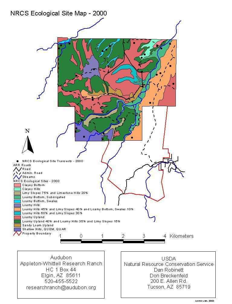
56
Horner-McLaughlin Woods: Soil Types
 Horner-McLaughlin Woods: Soil Types Not present at HMW Adrian Muck Conover Loam 0-4% Slopes Houghton Muck Miami Loam 2-6% Slopes Miami Loam 6-12% Slopes Miami Loam 12-18% Slopes t 0 0.125 0.25 Miles Mary
2011 Wisconsin Envirothon Soils and Land Use Exam
 2011 Wisconsin Envirothon Soils and Land Use Exam USE THE OCONTO COUNTY SOIL SURVEY TO ANSWER QUESTIONS 1-4 The Pensaukee River Wetland Complex is a mixture of state (Pensaukee Wildlife Area) and privately
2 Older farm homes on the land
 2 Older farm homes on the land LAND RANCHES EXCHANGES This ranch consists of 70 +/_ acres of level farmland. Prime 13700 POWERHOUSE RD POTTER VALLEY agricultural land at an attractive price. This property
TAXONOMIC CLASS: Loamy-skeletal, mixed, mesic Vitrandic Durochrepts
 ESRM311/SEFS507 Important Soil Series in Seattle Area ALDERWOOD SERIES The Alderwood series consists of moderately deep, moderately well drained soils formed in glacial till. Alderwood soils are on glacially
IOWA FFA STATE SOILS CDE SATURDAY, OCTOBER 13, 2007 AMES, IOWA
 IOWA FFA STATE SOILS CDE SATURDAY, OCTOBER 13, 2007 AMES, IOWA 1. Moderately sloping has what percent slope: a. 9-14% b. 2-5% c. 5-9% d. over 14% 2. Which of the following horizons is the loose underlying
Soil Maps for Production Agriculture. Jarrod O. Miller, Extension Agronomist
 Soil Maps for Production Agriculture Jarrod O. Miller, Extension Agronomist Origination of Soil Mapping Originally mapped by Division of Soils Federal Bureau of Soils Soil Conservation Service (SCS) started
Parent Material & some of Seattle s soils
 Parent Material & some of Seattle s soils ESRM 311/SEFS 507 Week 3 SOILS = f(cl, r, o, p, t) Parent Materials 1) Sedentary a) residual (bedrock weathered in place) b) organic 2) Transported by a) gravity
2014 Iowa FFA Soil Judging CDE Exam
 2014 Iowa FFA Soil Judging CDE Exam 1. Landscape position is one aspect of evaluating the surface features of a certain tract of land. Identifying the correct landscape position will indicate: a. If the
 108 40' 29'' W Soil Map Mesa County Area, Colorado 108 36' 55'' W 39 10' 11'' N 39 6' 31'' N 4331700 4332500 4333300 4334100 4334900 4335700 4336500 4337300 4338100 701100 701900 702700 703500 704300 705100
1. Position (2 pts.) 2. Parent Material (2 pts.) 3. Slope Characteristics (2 pts.) 4. Surface Stoniness or Rockiness (2 pts.)
 2. Parent Material (2 pts.) 3. Slope Characteristics (2 pts.) 4. Surface Stoniness or Rockiness (2 pts.)") Maryland Envirothon SOILS Exam Guidance Information (revised 2017) Objective: To test students' knowledge and awareness of basic soil science and its application in wise land-use planning and therefore
Maryland Envirothon SOILS Exam Guidance Information (revised 2017) Objective: To test students' knowledge and awareness of basic soil science and its application in wise land-use planning and therefore
Iowa FFA Soil Career Development Event 2008
 Iowa FFA Soil Career Development Event 2008 1. In Iowa, corn suitability ratings for soil mapping units specifies a. natural weather conditions b. surface and subsurface drainage installed where needed
2018 Iowa FFA Soil Judging CDE Exam 1. Landscape positions characterizes the location of the soil on the landscape and identifies potential risks.
 2018 Iowa FFA Soil Judging CDE Exam 1. Landscape positions characterizes the location of the soil on the landscape and identifies potential risks. Which landscape position is considered the floodplain
Unknown 1. Unknown 2 TEXTURE ANALYSIS
 Unknown 1 Unknown 2 TEXTURE ANALYSIS 1 5 8 11 1 22 1 12 10 Parent Material & some of Seattle s soils ESRM 311/SEFS 507 Week 3 SOILS = f(cl, r, o, p, t) Parent Materials 1) Sedentary a) residual (bedrock
Soil Interpretations Erosion and Sedimentation Control Planning and Design Workshop
 Soil Interpretations Erosion and Sedimentation Control Planning and Design Workshop Presented by Richard Brooks Presentation prepared by Kristin May Resource Soil Scientists USDA-Natural Resources Conservation
2012 FINAL SOILS AREA 2 Envirothon Questions Answer KEY
 2012 FINAL SOILS AREA 2 Envirothon Questions Answer KEY Questions 1-6 to be answered at the soil pit: 1. Soil scientists categorize soils by drainage classes. What is the drainage class of the soil at
Soil Physical Properties
 Soil Physical Properties ESRM 311 SEFS 507 Some examples of mineral soil development eg, Rock Weathering Types of Weathering Physical/Mechanical Chemical Biological Photo by D Vogt CO 2 + H 2 O H 2 CO
Erosion and Deposition & Land Use. Erosion & Deposition 2/18/2016. Soil Conservation Safeguarding soil from depletion and/or deterioration
 Soils & Land Use ESRM311- SEFS507 Erosion and Deposition & Land Use Redmond Ridge & Snoqualmie Valley Erosion & Deposition Definitions of erosion and deposition Examples of erosion and deposition Examples
2016 Area 3 Envirothon Muskingum County Soils Test ANSWER KEY
 2016 Area 3 Envirothon Muskingum County Soils Test ANSWER KEY 1. The majority of the bedrock in Muskingum County is. a. sedimentary bedrock b. glacial bedrock c. igneous bedrock d. metamorphic bedrock
2017 Iowa FFA Soil Judging CDE Exam
 2017 Iowa FFA Soil Judging CDE Exam 1. Landscape positions vary in soil composition and makeup. What landscape position would be characterized by having strata and lenses of different textures in the profile:
Pits 1 & 3 Questions. 7. Subsurface: Texture (5 pts) A. Coarse B. Moderately course C. Medium D. Fine E. Very Fine
 A. Coarse B. Moderately course C. Medium D. Fine E. Very Fine") Minnesota Soils Scorecard Questions for Pits 1-4 Scantron # 105481 Use your soils scorecard to fill out the answers on your scantron Bubble in the front side of the sheet for Pit 1 (# 1-45) and Pit 2 (#51-95)
Minnesota Soils Scorecard Questions for Pits 1-4 Scantron # 105481 Use your soils scorecard to fill out the answers on your scantron Bubble in the front side of the sheet for Pit 1 (# 1-45) and Pit 2 (#51-95)
2016 Iowa FFA Soils Evaluation CDE Exam
 2016 Iowa FFA Soils Evaluation CDE Exam 1. Which of the following is true regarding soil horizons? a. A horizon is darker in color and has more organic matter b. B horizon is darker in color and has more
SOIL CHARACTERIZATION USING DIAGNOSTIC PROPERTIES
 SOIL CHARACTERIZATION USING DIAGNOSTIC PROPERTIES The following are the characters of the pedologically important properties used in categorizing soils: SOIL CHARACTERIZATION Soil Profile Description:
Overview of Soil Properties
 Willie Harris apatite@ufl.edu Acknowledgments: Wade Hurt Mike Vepraskas FAESS Soil Scientists Overview of Soil Properties Website to download files of talks: wgharris.ifas.ufl.edu.hsw.htm Meaning of Soil
Overview of Soil Properties
 Willie Harris apatite@ufl.edu Acknowledgments: Wade Hurt Mike Vepraskas FAESS Soil Scientists Overview of Soil Properties Website to download files of talks: wgharris.ifas.ufl.edu.hsw.htm Meaning of Soil
Soil Survey of San Luis Obispo County, California Paso Robles Area
 United States Department of Agriculture Soil Conservation Service In cooperation with University of California Agricultural Experiment Station Soil Survey of San Luis Obispo County, California Paso Robles
Section 1. Judging the soil pit (questions 1-4)
") CONNECTICUT ENVIROTHON 2009 SOILS QUESTIONS Please select the best response to the following questions. There are 25 questions; each question is worth 4 points. Section 1. Judging the soil pit (questions
CONNECTICUT ENVIROTHON 2009 SOILS QUESTIONS Please select the best response to the following questions. There are 25 questions; each question is worth 4 points. Section 1. Judging the soil pit (questions
SOIL DATA: Avondale. in Allen, TX. This information was taken from NRCS web soil survey of Collin County, Texas.
 SOIL DATA: Avondale in Allen, TX This information was taken from NRCS web soil survey of Collin County, Texas. United States Department of Agriculture Soil Conservation Service in cooperation with Texas
September 20, 2016 Soils Investigation for Agricultural Designation Windemere Place, Missoula County, Montana
 September 20, 201 Soils Investigation for Agricultural Designation Windemere Place, Missoula County, Montana The purpose of this report is to compare on-site soils of the proposed subdivision with the
Land Capability Classifications
 Land Capability Classifications Unit: Soil Science Problem Area: Basic Principles of Soil Science Student Learning Objectives. Instruction in this lesson should result in students achieving the following
STATEMENT OF PHYSICAL CHARACTERISTICS AND AGRICULTURAL LAND CLASSIFICATION WITTON PARK, COUNTY DURHAM PROPOSED QUARRY EXTENSION DECEMBER 1992

Photographs and Descriptions of Representative Pedons by Site
 Photographs and Descriptions of Representative Pedons by Site Site: A Classification: Typic Vitricryand Location: North-central edge of the park; Northwest over Scarface ridge from Lake Eleanor. Dominant
Soil Texture = %Sand, Silt & Clay in a soil.
 Soils Soil Texture = %Sand, Silt & Clay in a soil. Soil texture is the single most important physical property of the soil. Knowing the soil texture alone will provide information about: 1) water flow
DO YOU KNOW YOUR SOILS? (Rev. 10/11)
") DO YOU KNOW YOUR SOILS? (Rev. 10/11) Circle all the correct answers. 1. What is the layer normally present on the surface of the soil in cropped fields? a. O c. Ap e. B g. R b. A d. E f. C 2. Available
DO YOU KNOW YOUR SOILS? (Rev. 10/11) Circle all the correct answers. 1. What is the layer normally present on the surface of the soil in cropped fields? a. O c. Ap e. B g. R b. A d. E f. C 2. Available
Soils and Land Use Test
 SOIL PROPERTIES Total Score /50 1) List two of the five main functions of soil. (2 points) Habitat for organisms, Engineering medium, Filters and stores water, Anchor for plants, Cycles nutrients 2) Small
URBAN SOILS & SEATTLE EXAMPLES
 Class Results - Mystery Soil #1 14 12 10 8 6 4 2 0 Sandy Clay Loam Sandy Loam Silty Loam Class Results - Mystery Soil #2 6 5 4 3 2 1 0 Silty Clay Clay Loam Sandy Sandy Silty Sandy Silty Loamy Loam Clay
 *2301001* Pit #1 ontestant #1 Team #1 alifornia DE - Soil and Land Evaluation Group: 1 ontestant: 1 SURFE SOIL (Fill in ONE bubble for each item). D 1. OLOR (5) 2. TEXTURE (5) 3. GRVEL ND ROK (3) 4. THIKNESS
Soil types of lake county
 Soil types of lake county Ad Adrian muck This deep, level, very poorly drained organic soil is in depressional areas on the lake plain. It is subject to frequent flooding. Slope is generally less than
If you are not able to turn in your notebook see me or Dan ASAP
 Notebook Collection Collecting hard copies now OR Electronic versions using Catalyst drop box Due by 5:30 pm today Use website for link If you are not able to turn in your notebook see me or Dan ASAP URBAN
STATEMENT OF PHYSICAL CHARACTERISTICS AND AGRICULTURAL LAND CLASSIFICATION
 STATEMENT OF PHYSICAL CHARACTERISTICS AND AGRICULTURAL LAND CLASSIFICATION BIRKWOOD FARM, ALTOFTS WEST YORKSHIRE Proposed Opencast Extraction of Clay and coal ADAS January 1990 Leeds Regional Office File
2014 Envirothon Georgia Soil Study Guide
 2014 Envirothon Georgia Soil Study Guide In addition to materials in this document, 2014 Georgia Envirothon contestants are responsible for materials found in the following documents: From The Surface
ATTACHMENT OP-5b. Lost Creek Project Order 1 Soil Survey - Access Road Corridors & Deep Well Injection Sites February 2010
 ATTACHMENT OP-5b Order 1 Soil Survey - Access Road Corridors & Deep Well Injection Sites February 2010 TABLE OF CONTENTS 1.0 Introduction... 1 2.0 Summary of Previous Soil Surveys... 1 3.0 Methodology...
AY-362-W. INDIANA SOIL Evaluation Field Book. Don Franzmeier, Gary Steinhardt, Cathy Egler Purdue University Department of Agronomy
 AY-362-W INDIANA SOIL Evaluation Field Book Don Franzmeier, Gary Steinhardt, Cathy Egler Purdue University Department of Agronomy Table of Contents PREFACE 3 CHAPTER 1 Soil Formation, Soil Properties,
NRCS Soils Report. Grand River Gathering LLC K28E Compressor Station. OA Project No
 NRCS Soils Report Grand River Gathering LLC K28E Compressor Station OA Project No. 012-032 82 21 ½ Road Grand Junction, CO 81505 TEL 90.23.800 FAX 90.23.45 United States Department of Agriculture A product
Should a landowner plant red alder?
 INTRODUCTION The decision to plant red alder is both biological and financial. This paper will address the biological aspects of red alder tree growing will red alder seedlings survive well, grow fast,
Soil Properties That Distinguish Ecological Sites
 Soil Properties That Distinguish Ecological Sites Mike Duniway USGS-Southwest Biological Science Center Canyonlands Research Station Moab, UT mduniway@usgs.gov Spokane, WA January 31, 2012 Ecological Sites
SOILS IN URBAN / SUBURBAN LANDSCAPES. Lisa Krall Soil Scientist CT USDA NRCS Tolland, CT
 SOILS IN URBAN / SUBURBAN LANDSCAPES Lisa Krall Soil Scientist CT USDA NRCS Tolland, CT What is Urban Soil? Is This Soil? Is This Soil? active gravel pit pavement and buildings vegetated roadside areas
SITE ASSESSMENT AND SEPTIC EVALUATION FOR JASON & JANET THATCHER 201 N. SPRAGUE AVED KINGSTON, PA 18704
 DATE: December 13, 2010 N.H. LICENSED DESIGNER OF SUBSURFACE DISPOSAL SYSTEMS 216 Hill Road Phone & Fax: 934-6206 Franklin, NH 03235 Cell: 393-3085 SITE ASSESSMENT AND SEPTIC EVALUATION FOR JASON & JANET
Custom Soil Resource Report for Franklin County, Washington
 United States Department of Agriculture Natural Resources Conservation Service A product of the National Cooperative Soil Survey, a joint effort of the United States Department of Agriculture and other
Learning Objectives Part 1. Chapter 4 Soil Physical Properties. Soil Physical Properties. Color. Physical properties part 1
 Learning Objectives Part 1 Chapter 4 Soil Physical Properties Know what color tells you about a soil Describe the concept of soil texture and its importance Use the textural triangle to determine a soil
Custom Soil Resource Report for Choctaw County, Oklahoma, and McCurtain County, Oklahoma
 United States Department of Agriculture Natural Resources Conservation Service A product of the National Cooperative Soil Survey, a joint effort of the United States Department of Agriculture and other
PROPOSED OPEN CAST COAL SITE SEPTEMBER 1992
 AGRICULTURAL LAND CLASSIFICATION AND STATEMENT OF PHYSICAL CHARACTERISTICS SKIERS SPRING, HOYLAND, SOUTH YORKSHIRE PROPOSED OPEN CAST COAL SITE SEPTEMBER 1992 ADAS LEEDS STATUTORY GROUP Job No. 98/92 MAFF
The Nature of Soil Soil Conservation Sustainable Ag.
 Chapter 6 & 7 The Nature of Soil Soil Conservation Sustainable Ag. Climate Soil Forming Factors Parent material Organisms Topography Time Value of Soil Soil is under appreciated Condition of soil affects
Soil Colors, Texture & Structure
 Application Soil Colors, Texture & Structure Limiting conditions Soil color type/depth of system Bedrock type/depth of system Soil texture, structure, percolation rate size and type of system Sara Heger,
LAND JUDGING AND SOIL EVALUATION
 LAND JUDGING AND SOIL EVALUATION June 1998 W. J. Edmonds, P. J. Thomas, T. W. Simpson, and J. C. Baker Virginia Polytechnic Institute and State University Department of Crop and Soil Environmental Sciences
Soils Investigation Nevada Youth Range Camp
 Soils Investigation Nevada Youth Range Camp Curriculum Material 10-08 Sherman Swanson, State Range Specialist John Fisher, Soil Scientist, USDA Natural Resources Conservation Service This curriculum is
MAFF Ministry of Ifinil Agriculture Rsheries and Food
 MAFF Ministry of Ifinil Agriculture Rsheries and Food STATEMENT OF PHYSICAL CHARACTERISTICS AND AGRICULTURAL LAND CLASSIFICATION SHILBOTTLE COLLIERY RECLAMATION SCHEME NORTHUMBERLAND DECEMBER 1994 ADAS
Custom Soil Resource Report for Ulster County, New York
 United States Department of Agriculture Natural Resources Conservation Service A product of the National Cooperative Soil Survey, a joint effort of the United States Department of Agriculture and other
Land Judging and Homesite Evaluation Guidebook
 Land Judging and Homesite Evaluation Guidebook Kansas State University Agricultural Experiment Station and Cooperative Extension Service INTRODUCTION The study of land and its wise use should be important
Custom Soil Resource Report for Craighead County, Arkansas
 United States Department of Agriculture Natural Resources Conservation Service A product of the National Cooperative Soil Survey, a joint effort of the United States Department of Agriculture and other
Examining soils in the field. Examining soils in the field. Environment Agency thinksoils examining soils in the field
 Examining soils in the field thinksoils Examining soils in the field Environment Agency thinksoils examining soils in the field 31 Examining soils in the field 32 Environment Agency thinksoils examining
ASCE - Philadelphia. Soils & Stormwater Management. Matthew C. Hostrander, CPSS, SEO Soil Scientist. Gilmore & Associates, Inc.
 ASCE - Philadelphia Soils & Stormwater Management Matthew C. Hostrander, CPSS, SEO Soil Scientist Gilmore & Associates, Inc. Course Overview COURSE OUTLINE Soil Science Fundamentals Discuss United States
Do Now: From which materials do you think soil is made? Are all soils the same? Think of some ways that they are different?
 Do Now: From which materials do you think soil is made? Are all soils the same? Think of some ways that they are different? Basics Soil is a major component of the biosphere It contains solids, liquids
PHYSICAL CHARACTERISTICS REPORT INCORPORATING AGRICULTURAL LAND CLASSIFICATION LAND AT BOLE INGS, WESTBURTON, NOTTINGHAMSHIRE (SK805875)
") (krahs 2% I?5 PHYSICAL CHARACTERISTICS REPORT INCORPORATING AGRICULTURAL LAND CLASSIFICATION LAND AT BOLE INGS, WESTBURTON, NOTTINGHAMSHIRE (SK805875) 1.0 INTRODUCTION 1.1 The site, an area of 84.5 hectares,
(krahs 2% I?5 PHYSICAL CHARACTERISTICS REPORT INCORPORATING AGRICULTURAL LAND CLASSIFICATION LAND AT BOLE INGS, WESTBURTON, NOTTINGHAMSHIRE (SK805875) 1.0 INTRODUCTION 1.1 The site, an area of 84.5 hectares,
During the field surveys, several species of wading birds and ducks were observed using permanently ponded areas.
 Preliminary Engineering / Environmental Impact Statement Northwest Corridor LRT Line to Irving and DFW Airport During the field surveys, several species of wading birds and ducks were observed using permanently
SUBSURFACE DRIP DISPERSAL OF EFFLUENT for LARGE SYSTEMS. Presented by: David Morgan and Rodney Ruskin
 SUBSURFACE DRIP DISPERSAL OF EFFLUENT for LARGE SYSTEMS Presented by: David Morgan and Rodney Ruskin Program Map Making Program Soil Parent material, Relief, Time. Organisms, Color, Texture, Depth, Profile
EDULABZ. Ans. (b) 7. The soft, porous layer with a good water-retaining capacity forms the
 7. The soft, porous layer with a good water-retaining capacity forms the") 3 SOIL I. Multiple choice questions: Tick ( ) the correct choice. 1. The process of soil formation is called (a) conservation (b) weathering (c) erosion (d) none Ans. (b) 2. Soil profile consists of (a)
3 SOIL I. Multiple choice questions: Tick ( ) the correct choice. 1. The process of soil formation is called (a) conservation (b) weathering (c) erosion (d) none Ans. (b) 2. Soil profile consists of (a)
Team number Page 1 of Canon Envirothon Soils Station Test. Soils and Climate Change
 Team number Page 1 of 9 2006 Canon Envirothon Soils Station Test Soils and Climate Change There are many kinds of soil on the surface of the earth. The kind of soil that is present at a given location
Loam: About 40% sand, 40% silt, 20% clay. Mixture of pore sizes to balance water retention and aeration. Considered the best soil for growing crops.
 Soil Characteristics Soil is formed from a combination of two Primary sources: Weathering of Parent Rock ( ) = material introduced by plants, animals, and decomposers Minor sources: Nutrients incorporated
Soil Structure, Density, and Porosity. Laboratory #4
 Soil Structure, Density, and Porosity Laboratory #4 Objectives Understand the concept of soil structure and how it differs from soil texture. Understand how soil structure influences other soil properties.
SOILS OF THE FREEMAN RANCH, HAYS COUNTY, TEXAS
 Freeman Ranch Publication Series No. 4-2000 July, 2000 SOILS OF THE FREEMAN RANCH, HAYS COUNTY, TEXAS Dee Carson Department of Agriculture Southwest Texas State University San Marcos, Texas 78666 INTRODUCTION
Custom Soil Resource Report Soil Map
 77 11' 22'' W Custom Soil Resource Report Soil Map 77 9' 43'' W 36 48' 13'' N 304700 304900 305100 305300 305500 305700 305900 306100 306300 306500 306700 306900 307100 36 48' 13'' N 36 47' 21'' N 4073800
a. OVERALL PROFILE DEPTH: Assess the depth to the first restrictive layer, which can be a tree root, a rock or an
 OBSERVING SOIL PROCEDURE Using a shovel, soil probe, or soil auger, collect a soil profile. (Go as deep as you can with the equipment). Arrange the soil you remove from the ground on newspaper or in a
3.44b. Soil Classification AK & BR
 3.44b Soil Classification AK & BR Why look at soil? Because soil and its constituents are the base material for growing trees. History Why a Forestry Commission soil classification? There is a need for
Soils and the Environment. A Summary of RI Envirothon Study Materials Compiled by Sally Paul
 Soils and the Environment A Summary of RI Envirothon Study Materials Compiled by Sally Paul Why Soils Food and water resources Disposing of waste Support for human structures Growing timber and fibers
Soil Notes. General Soil Information
 Soil Notes General Soil Information Definition Soil relatively thin surface layer of the Earth s crust consisting of mineral and organic matter that is affected by agents such as weather, wind, water,
5 RESULTS FOR THE REJECT EMPLACEMENT AREA
 SPECIALIST CONSULTANT STUDIES 9b - 21 NARRABRI COAL OPERATIONS PTY LTD of the REA, BSA and Water Pipeline Report No. 674/17 5 RESULTS FOR THE REJECT EMPLACEMENT AREA 5.1 Introduction From the information
NRCS Soils Report. Encana Oil & Gas (USA) Inc. C19 Injection Well. OA Project No
 Inc. C19 Injection Well. OA Project No") NRCS Soils Report Encana Oil & Gas (USA) Inc. C19 Injection Well OA Project No. 012-0178 826 21 ½ Road Grand Junction, CO 81505 TEL 970.263.7800 FAX 970.263.7456 United States Department of Agriculture
NRCS Soils Report Encana Oil & Gas (USA) Inc. C19 Injection Well OA Project No. 012-0178 826 21 ½ Road Grand Junction, CO 81505 TEL 970.263.7800 FAX 970.263.7456 United States Department of Agriculture
Area 3 Envirothon Soils Questions Key
 Area 3 Envirothon Soils Questions Key 1. Soil aeration is the exchange of air in soil with air from the atmosphere. When a soil is well aerated, the air within the soil is very similar to the atmosphere
Topoclimate Southland Soil Technical Data Sheet No Waiau
 This Technical Data Sheet describes the typical average properties of the specified soil. It is essentially a summary of information obtained from one or more profiles of this soil that were examined and
AGRICULTURAL LAND CLASSIFICATION AND SOIL PHYSICAL CHARACTERISTICS BIRCH PIT, NEAR COLCHESTER ESSEX
 AGRICULTURAL LAND CLASSIFICATION AND SOIL PHYSICAL CHARACTERISTICS BIRCH PIT, NEAR COLCHESTER ESSEX AGRICULTURAL LAND CLASSIFICATION AND SOIL PHYSICAL CHARACTERISTICS SEMI-DETAILED SURVEY BIRCH PIT, NEAR
AGRICULTURAL LAND CLASSIFICATION AND STATEMENT OF PHYSICAL CHARACTERISTICS
 AGRICULTURAL LAND CLASSIFICATION AND STATEMENT OF PHYSICAL CHARACTERISTICS DALE PIT FARM. HATFIELD VOODHOUSE PROPOSED EXTRACTION OF SAND AHD GRAVEL ADAS April 1989 Leeds Regional office File Ref: 2FCS
4H HPS 101 Land Judging In Oklahoma
 4H HPS 101 Land Judging In Oklahoma Extension 4-H MEMBER S GUIDE Oklahoma Cooperative Extension Service Division of Agricultural Sciences and Natural Resources Oklahoma State University 1 Table of Contents
AGRICULTURAL LAND CLASSIFICATION AND STATEMENT OF PHYSICAL CHARACTERISTICS
 AGRICULTURAL LAND CLASSIFICATION AND STATEMENT OF PHYSICAL CHARACTERISTICS SEGHILL, NORTHUMBERLAND PROPOSED VASTE DISPOSAL SITE ADAS January 1989 Leeds Regional Office REF: 3/89 2FCS 4191 lds.rpg3.seghill
Soil & Site Evaluator - Need to Know
 Soil & Site Evaluator - Need to Know I. The professional will understand the factors of soil development and demonstrate their importance to site evaluations. A. Topography 1. Landscape & landform description
Understanding Soils. 1. What is Soil? 2. What does soil do for us?
 Understanding Soils 1. What is Soil? Soil: (i) The unconsolidated mineral or organic material on the immediate surface of the earth that serves as a natural medium for the growth of land plants. (ii) The
THE SCORE CARD. Observed Soil Properties. Interpretive Soil Properties
 Rev. 07/18/2008 Jim Doolittle Doug Malo Tom Schumacher Plant Science Department SDSU and Kent Cooley Lance Howe Bruce Kunze Jim Millar Walt Schaefer Dan Shurtliff Steve Winter USDA Natural Resources Conservation
Kenya Agricultural Research Institute Kenya Soil Survey P.O. Box Tel: /
 Kenya Agricultural Research Institute Kenya Soil Survey P.O. Box 14733-00800 Tel: 4443376/4440903 E-mail - kss@iconnect.co.ke NAIROBI THE SOIL CONDITIONS OF SIX EXPERIMENTAL SITES IN MACHANG A, EMBU, KIREGE,
AGRONOMY NOTES. Vol. 29, No. 5, 1996
 AGRONOMY NOTES Vol. 29, No. 5, 1996 Differential Black Walnut Growth on a Recommended Soil Map Unit: Investigation of Related Soil Chemical and Physical Properties D.C. Ditsch, J. Stringer and D. McIntosh
Soil characteristics that influence nitrogen and water management
 Section C Soil characteristics that influence nitrogen and water management Soil characteristics vary across the landscape Soils vary from one field to another, and often within the same field. Soil differences
Custom Soil Resource Report for McCurtain County, Oklahoma
 United States Department of Agriculture Natural Resources Conservation Service A product of the National Cooperative Soil Survey, a joint effort of the United States Department of Agriculture and other
STATE TAX COMMISSION OF MISSOURI ASSESSOR MANUAL
 STATE TAX COMMISSION OF MISSOURI ASSESSOR MANUAL CHAPTER: REVISION DATE: 10/1/2008 Page 1 of 18 7.3 The purpose of this section of the Assessor s Manual is to supplement the State Tax Commission s published
Agricultural Land Classification and Statement of Physical Characteristics Higbfield Farm Whitley Bridge North Yorkshire October 1996
 Agricultural Land Classification and Statement of Physical Characteristics Higbfield Farm Whitley Bridge North Yorkshire October 1996 Resource Planning Team ADAS Reference: 82/96 Leeds Statutory Group
Sam Houston Ranger District West/Central WUI Fuels Reduction Project Soil and Water Resources
 Soil and Water Resources The Sam Houston National Forest has identified specific wildland urban interface (WUI) areas within Compartments 33, 36, 37, 49, 57, and 66 that contain high fuel loadings. This
The entire site supports grass on which sheep had been grazing recently.
 PHYSICAL CHARACTERISTICS REPORT FOR LAND AT HORSEHAY A^ Agricultural Land Classification of approximately 14 hectares of land to the southwest of Horsehay was undertaken in November 1989. The site lies
AGRICULTURAL LAND CLASSIFICATION AND SOIL PHYSICAL CHARACTERISTICS LAND NEAR SHIRE HILL FARM SAFFRON WALDEN ESSEX
 AGRICULTURAL LAND CLASSIFICATION AND SOIL PHYSICAL CHARACTERISTICS LAND NEAR SHIRE HILL FARM SAFFRON WALDEN ESSEX AGRICULTURAL LAND CLASSIFICATION (ALC) AND SOIL PHYSICAL CHARACTERISTICS LAND NEAR SHIRE
Reference Card S-2, Side A: Delineating Horizon Boundaries
 Reference Card S-2, Side A: Delineating Horizon Boundaries Distinguishing Soil Horizons Soil horizons are delineated based on differences in: Texture Color Structure and Consistence Redoximorphic Features
Soil Characterization Protocol
 Soil Characterization Protocol Purpose To characterize the physical and chemical properties for each horizon in a soil profile and prepare samples for further analysis Overview Students identify the horizons
Soil & Site Evaluator - Need to Know
 Soil & Site Evaluator - Need to Know I. The professional will understand the factors of soil development and demonstrate their importance to site evaluations. A. Topography 1. Landscape description 2.
AGRONOMY 255, 251, 270 SOIL DIFFERENCES
 Name AGRONOMY 255, 251, 270 SOIL DIFFERENCES Soils differ strikingly from each other. This week we illustrate the great differences and ask you to learn how they differ and to become skilled in describing
1 Describe the concept of soil texture and its importance. 2 Determine the texture of a soil sample.
 Interest Approach Provide students with various samples of soil. One sample should be nearly all sand, one nearly all clay, and one nearly all silt. Ask students to determine how the samples differ. Would