4. Characterisation of Materials
|
|
|
- Jack Preston
- 5 years ago
- Views:
Transcription
1 4. Characterisation of Materials 4.1 SAMPLING AND ANALYTICAL METHODS Main horizons of a representative Ahaura series profile under standing partially cutover beech-podocarp forest were sampled for chemical and panicle size analyses. These samples represent the undisturbed or natural in-situ soil as a control for comparison with the reconstituted soil and other materials. Soil and other materials were sampled in duplicate from each of the trial plots. These comprised: topsoil and organic layers combined, subsoil, mixed soil materials, fines (<2 mm) in both the surface and underlying overburden gravels. In addition, duplicate samples of mudstone/sandstone overburden were collected from a subsidiary demonstration trial at the mine site. This trial is situated at another location on the mining site and is not directly comparable with the principal research trial described in this report. However, the results are included in this report for convenience and as a reference for comparison of materials. The methods used for chemical analyses are described by Blakemore et al. (1987). Particle size analysis of the fine earth fraction (<2 mm) was determined by the method of Claydon (1989). Chemical analyses and ratings for chemical properties have not been directly linked to the potential growth of indigenous woody vegetation. Only Bray-P levels and amounts of 0.5M-HCl-soluble Mg (Mgr) have been related to foliar levels in trees (Pinus radiata). However, the relative ratings are internally consistent and form a basis from which change can be monitored and growth can perhaps eventually be related. 4.2 RESULTS AND DISCUSSION Soil Chemistry Results for the soil chemical analyses are presented in Tables 1 and 2. Note: Trace elements were not analysed in this study. 4.2.la In-situ Ahaura soil Chemical analyses for the four horizons sampled from an in-situ Ahaura series soil show the soil to be acidic and of relatively low natural fertility. Most of the plant nutrients that were analysed were concentrated in the surface organic layers. This suggests that the organic matter is likely to be a very important source of plant nutrients for this soil. 16
2 TABLE 1. SOIL AND OVERBURDEN CHEMISTRY (ANALYSTS: K.M. GIDDENS, L.J. GILLIGAN, C.D. MORGAN, H.W. RURU, M.D. TAYLOR, D.J. VICKERS.)

3 TABLE 2. CHEMISTRY OF MUDSTONE/SANDSTONE OVERBURDEN ON DOC DEMONSTRATION TRIAL. (ANALYSTS: K.M. GIDDENS, L.J. GILLIGAN, P.L. SEARLE.)
4 The ph ranges from extremely acid in the organic and topsoil horizons to moderately acid in the subsoils. Exchangeable-Al is medium-high in the upper horizons, decreasing significantly in the subsoil. These results suggest that plants tolerant of acidic soil conditions are most suited for revegetation if lime is not applied. Predictably, organic-matter contents decrease with depth down the soil profile. Cation exchange capacities follow a similar trend, ranging from very high in the organic layers to very low in the lower subsoil. Exchangeable cations are at medium levels in the organic horizons but decrease significantly in the mineral soil horizons, with negligible levels in the lower subsoil. The cation exchange data indicate that the soil is strongly leached. Phosphorus contents are generally low to very low, suggesting that P deficiency may affect plant gowth. However, a high content of Bray-P was measured in the lower subsoil, probably indicating the presence of primary apatite minerals from the alluvial gravels parent material. This hypothesis is supported by the high Bray-P contents for the fines from the overburden gravels. Sulphate-S increases down the profile from low or very low to medium levels in the subsoil. Reserve Mg is low in the upper two horizons and very high in the subsoil. 4.2.lb Rehabilitated soil materials The chemistry of the soil placed by the original horizons on the trial tends to reflect the differentiation between the organic and topsoil layers and the subsoil. Values for all chemical attributes for the surface materials tend to be intermediate between those for the organic horizons and the mineral topsoil (Ah). Similarly, the respread subsoil tends to exhibit chemical characteristics between the upper (Bs) and lower (BC) subsoil. The respread subsoil has slightly higher organic matter levels and exchangeable bases compared to the in-situ subsoil. This probably results from some minor inclusions of topsoil and organic matter during the earthmoving operations. The respread mixed soil samples have somewhat variable chemistry, indicating the inhomogeneous nature of this material. In general, the chemical attributes for the mixed soil are similar to those for the upper subsoil (Bs) of the in-situ soil. KCl-Al levels are somewhat higher, approximating the value for the in-situ organic layer. 4.2.lc Fines in the gravels The chemistry of the fine (<2 mm) materials in the gravels is significantly different from that of the soil materials. The fines are moderately to slightly acidic, have low exchangeable-al levels, and very low organic-matter contents. Nitrogen deficiency is likely to be a significant constraint for plant growth with respect to non-leguminous species. This material has very low cation exchange capacity and exchangeable cations. In contrast, phosphorus contents are significantly higher, especially Bray-P, indicating that this may be an important potential source of P for tree nutrition. SO 4 -S is low and reserve Mg is high. 19
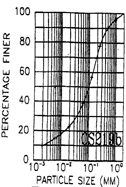
5 4.2.ld Overburden mudstone/sandstone The overburden mudstone/sandstone has a significantly different chemical composition compared to the soil materials and the fines in the overburden gravels. Overall, the overburden mudstone/sandstone has a higher nutrient status than most of the soil materials, with the exception of nitrogen, which is lacking. This overburden material is only slightly acidic to near neutral, has no detectable exchangeable-al and has low to medium carbon contents, depending on the amount of coal inclusions. The cation exchange capacity is medium to high as a consequence of the higher clay content compared to the soil materials (see particle size results). Exchangeable cations and the percentage base saturation are significantly higher than the soil materials. Phosphorus contents are low to medium whereas S0 4 -S is high to very high. Reserve Mg is at medium levels. These data suggest that the overburden mudstone/sandstone has a chemical composition which significantly differentiates it from the gravels and soils as a potential plant growth medium for land restoration. However, its physical characteristics may be a major limiting factor (see the following section) Particle Size Distribution Particle size distribution data are given in Tables 3 and 4 and grading curves are presented in Figure 11. The soil materials in the sample of Ahaura soil horizons and in the respread soil materials on the trial plots are relatively coarse textured predominantly sandy loams (texture classes described by Milne et al. 1991). Two samples have loamy sand textures the lower subsoil of the in-situ Ahaura profile and one of the respread topsoil/organic material samples. Clay contents range from 5% to 16%, silt 15-34% and sand 54-79% (Table 3). Fine sand ( mm) tends to be the dominant sand fraction. The fines (<2 mm fraction) in the overburden gravels have contrasting particle size distributions to the soil materials. They have sand textures and are dominated by the coarse sand fraction (2-0.6 mm). Silt contents are minimal (10-12%) and there is a very low content of clay (0-4%). The soil materials tend to be well graded (Fig. 11) whereas the gravel fines are more uniformly graded materials. However, a complete particle size analysis of the bulk materials in the gravels, including stones and boulders, would demonstrate a predominance of very coarse particles (boulders). Because the stones and boulders are regarded as inert in terms of water and nutrient supply to plants, they have not been assessed in this study. Effort has been concentrated on characterising the fines which are of importance for root growth and development. 20
6 TABLE 3. PARTICLE SIZE DISTRIBUTION - FINE EARTH FRACTION (<2 MM). (ANALYST: J. CLAYDON)
7 TABLE 4. PARTICLE SIZE DISTRIBUTION - FINE EARTH FRACTION (<2 MIN) OF MUDSTONE/SANDSTONE OVERBURDEN ON DOC DEMONSTRATION TRIAL. OVERBURDEN LAB. NO. COARSE MEDIUM FINE SILT CLAY SAMPLE SAND SAND SAND mm mm mm <0.002 mm (%) (%) (%) mm (%) (%) 1 CS540a CS540b A general assessment of the physical properties of the soil materials shows that the good drainage and friable consistence of the in-situ Ahaura soil is in accord with the sandy loam textures. However, the coarse textures, uniform particle size gradings and inherently weak soil structures potentially make the soil particularly prone to compaction and physical degradation from earthmoving operations. Compaction and structural breakdown is likely to adversely affect the drainage characteristics and possibly also soil aeration. Some surface ponding has been observed on the trial. The coarse soil textures tend to be in accord with the chemical characteristics such as the strongly leached status and relatively poor nutrient levels in the mineral soil horizons,. The overburden gravels are inherently excessively drained and drought-prone. Field evidence shows that compaction by machinery can cause some localised impeded drainage and surface ponding under heavy rainfalls, which contrasts with the natural physical properties. Low chemical buffering capacity and relative chemical inertness are consistent with the coarse sandy texture of the gravels matrix of fines. The overburden mudstone/sandstone has significantly higher contents of clay (29-44%) and silt (37-48%) compared to the soil materials (Table 4). These materials have silty clay or clay loam textures (Milne et al. 1991). The finer textures are consistent with the higher nutrient status of these overburden materials. However, field observations indicate that the mudstone, in particular, is weakly structured and, once exposed in stockpiles or on the surface, breaks down readily under heavy rainfall. This leads to surface sealing and ponding of water in hollows. Hence, physical conditions for future plant growth favour plants adapted to such wet conditions unless amelioration techniques or conditioning materials are used. 4.3 CONCLUSIONS FROM CHARACTERISATION OF MATERIALS The in-situ Ahaura soil materials are acidic and of relatively low natural plant nutrient status. Most of the plant-available nutrients are concentrated in the organic matter which is, however, extremely acidic. 22

 in the overburden gravels are relatively inert, but this material is a potential source of phosphorus for magnesium for plant nutrition.")

8 FIG. 11 PARTICLE SIZE GRADING CURVES - REFER TO TABLES 3 AND 4 FOR SAMPLE DESCRIPTION. The chemical characteristics of,the placed soil by original horizons tend to be intermediate between the in-situ derivative materials. That is, the upper respread layer has soil chemmcal levels intermediate between the upper (Bs) and lower (BC) subsoils. The matrix fines (<2 mm) in the overburden gravels are relatively inert, but this material is a potential source of phosphorus for magnesium for plant nutrition. The mudstone/sandstone overburden on the demonstration trial plots has a higher fertility status compared to the soil materials, especially the cations and sulphate-s, except for nitrogen which is very limiting. Sandy loam textures predominate in the soil materials. The overburden gravels have a coarse sand matrix. The mudstone overburden has silty clay or clay loam textures. The soil materials are freely draining in-situ but may exhibit degraded physical conditions as a consequence of structural breakdown and compaction caused by earthmoving operations for site rehabilitation. The overburden gravels are drought-prone, and also plant growth may be impeded as a consequence of compaction. The respread overburden mudstone has poor physical characteristics for plant gowth. Plants tolerant of impeded drainage are recommended for this material. 23


9 24


10 5. General Discussion and Conclusions The soil analyses used for characterising the materials of the rehabilitation trials and the in-situ soil provide a general measure of their chemical and physical properties. Interpreting the results for the specific physical and nutritional requirements of a range of indigenous woody plant species has a high degree of uncertainty. There is little or no documented information on the specific soil fertility needs for the indigenous forest species being tested in these trials. Although this research programme will help our understanding of the interactions of rehabilitated plant growth media and native plant responses for some mining sites, there are fundamental questions on the soil chemical and physical requirements of indigenous plants which remain to be investigated. 2 5
11 2. Particle size distributions are amongst the most basic forms of soil physical data. There are broad associations between particle size distribution and other physical properties which have more direct impact on plants for example, moisture retention, hydraulic conductivity, aeration, soil strength or penetration resistance, etc. However, particle size distributions provide only a very generalised soil physical measurement for interpreting plant response. In order to gain a better understanding of the effects of physical conditions of soil, or other media, on the revegetation process, periodic measurements are being made of the soil moisture status (in the saturated to slightly unsaturated range using tensiometry) and oxygen diffusion rates (ODR a measure of aeration conditions in the rooting zone). Correlations between the particle size properties of the different materials used in the trial, ODR and moisture conditions, and plant response will be evaluated when sufficient results are available. 3. Visual observations of surface ponding on the respread overburden gravels are somewhat surprising, given the extremely coarse texture of these materials. Earthmoving and compaction by heavy machinery seems to cause sufficient densification and close particle packing to inhibit water movement through the gravels that normally drain freely. An extension to the research programme would be necessary to further study how and why there is an apparent surface drainage impediment in the compacted respread gravels. 4. Changes in the soil hydrology from the natural forest ecosystem are highly likely for the rehabilitated soils. Under the forest canopy, rainfall is concentrated by stem flow and by dripping from the leaves and branches. In contrast, rainfall is distributed more-or-less evenly across the rehabilitation trial site because it lacks a vegetation canopy at this stage of revegetation. In addition, preferential water flow pattems down through the natural in-situ soil along root channels, worm holes, etc. are disrupted and not generally present in the rehabilitated soils. Both factors, along with the changes in the organic cycling regime, are likely to strongly influence soil leaching conditions. The consequences of these changes on soil properties and consequential plant responses are unknown. Sampling the trial soil materials after 5 and 10 years would indicate the longer-term trends in changes to the soil materials consequent to stripping, respreading and revegetation. Consolidation of the soil materials with time is being monitored. Other changes in soil organic-matter contents and soil chemistry are not being regularly monitored in the short term. However, further analytical soil testing at 5 and 10 years after rehabilitation is planned and is recommended in order to make predictions about the future soil conditions and long-term vegetation changes. 5. There is a significant contrast between the soil materials on the rehabilitation trial site and the overburden mudstone/sandstone used for the demonstration trial. The overburden mudstone used was from a buried geologic stratum from immediately above the coal seams. It contained some contamination of coal but no soil materials. 26
12 The differences between the physical and chemical characteristics of the overburden mudstone and the soil materials are likely to have long-term ecological implications for site restoration. It is postulated that two substantially different vegetation types will grow on the two different materials in the absence of any substantial management. 6. Research Opportunities 1. Relate plant establishment and growth of indigenous beech-podocarp forest species to soil chemical and physical properties. Associated with this potential research is a need to establish accurate fertiliser responses for a wide range of indigenous forest plants. Work is also required to establish the relationships between the chemical contents of foliage of native trees and shrubs and soil chemical properties. 2. Monitoring and adjusting the continuing management of the rehabilitated and revegetated mined areas will be necessary to ensure environmentally acceptable outcomes. Weed and animal control are of critical importance. Maintenance or booster fertiliser applications may be required to stimulate the development and growth of preferred trees and shrubs. 3. Soil materials on the trial plots should be resampled at 5 and 10 years for comparative analyses aimed at detecting changes in soil properties with time. This information, together with the results and trends from the revegetation studies, will indicate likely consequences of the rehabilitation techniques for the long-term forest ecology. 4. Investigation of the reasons for the apparent surface drainage impediment in the compacted respread gravels. 7. Acknowledgements This project is funded by the Department of Conservation. Special thanks to the following DoC staff or former staff for their assistance and help with the research programme. Michael Orchard, Iain Buckman, the West Coast Conservancy CASs. Robin Birchfield and staff at the Dunollie Giles Creek Coal Mine for their willing assistance with the project and particularly for the earthworks. The following Landcare Research staff also made significant contributions: David McQueen (field assistance); staff in the Analytical Laboratory: Tessa Roach (wordprocessing); Tony Pritchard (editorial assistance and reviewing the report). The research programme is a collaborative venture with Lisa Langer and Murray Davis, FRI, Christchurch, and Rick Jackson, Landcare Research, Christchurch. 27
13 8. Appendices 8.1 DETAILED PROFILE DESCRIPTIONS Soil Name: Ahaura Stony Sandy Loam Description of Profile No. : GC91/1 Author: CWR, DMcQ; Date: 6-Feb-1991 Map reference: L Map Series: NZMS 260 Classification: Yellow-brown earth, Acidic Allophanic Brown Soil Survey: Land Restoration Trial, Giles Ck Region: Nth Westland Location: Giles Creek Coal Nine Area Topdressing: Nil Annual Rain: mm Elevation: 180 m Landform: Surface of terrace in terrace system Flooding: Less than one year in 10 Microrelier: Forest dimpled Drainage: Well Land Use: Former forestry Vegetation: Silver and mountain beech forest Parent Materials: Weakly weathered, granite alluvium Notes: Vegetation type is indigenous cutover forest being cleared for coal mining. Sampled profile for chemical and particle size characterisation. Horizon Depth Horizon description (cm) H 0-12 Very dusky red (2.5YR 2.5/2) humus; loose soil strength; uncemented; moderately developed fine crumb structure; abundant coarse roots; moist; very thin litter and fermentation layers at surface; indistinct wavy boundary. Ah Dark brown (7.5YR 3/2) stony sandy loam; weak soil strength; uncemented; friable; moderately developed medium block structure breaking to moderately developed fine nut; few coarse roots; many moderately weathered rounded granite stones; distinct irregular boundary. Bs Strong brown (7.5YR 5/8) very stony silt loam; few dark brown (7.5YR 3/3) distinct organic coatings on ped faces; weak soil strength; uncemented; firm; weakly developed fine block; few coarse roots; many strongly weathered rounded granite stones; indistinct wavy boundary. BC Light yellowish brown (2.5Y 6/4) gravelly loamy coarse sand; very weak soil strength; uncemented; very friable; single grained; no roots; weakly to moderately weathered granite gavels; few coarse inclusion of Bs materials. 28
14 Soil Name: Ahaura Fine Sandy Loam Description of Profile No. : GC90/12 Author: CWR, GM Date: 6-Jun-1989 Map reference: L Map Series: NZMS 260 Classification: Yellow-brown earth, Acidic Allophanic Brown Soil Survey: Land Restoration Trial, Giles Creek Region: North Westland Location: Giles Creek Coal Mine Area Topdressing: Nil Annual Rain: 3200 mm Elevation: 180 m Landform: Surface of terrace in terrace system Flooding: Less than one year in 1 0. Microrelief: Forest dimpled Drainage: Well drained Land Use: Former forestry Vegetation: Silver and mountain beech forest Parent Materials: Weakly weathered, granite alluvium Notes: Vegetation type is indigenous cutover forest. Horizon Depth Horizon description (cm) H 0-8 Dark reddish brown (5YR 2/2) humus; loose soil strength; uncemented; weakly developed fine crumb structure; abundant medium live roots; moist; distinct wavy boundary. Ah 8-17 Brown to dark brown (7.5,YR 4/2) fine sandy loam; moderately weak soil strength; uncemented; weakly developed fine nut structure; common medium live roots; moist; few worms; indistinct wavy boundary. Bs Strong brown (7.5YR 5/8) stony silt loam; moderately weak soil strength; uncemented; weakly developed medium blocky structure breaking to weakly developed fine blocky structure; few distinct brown to dark brown (7.5YR 4/4) organic coatings; many moderately weathered subrounded granite stones; few fine live roots; moist; diffuse smooth boundary. Bs Strong brown (7.5YR 5/6) stony silt loam; moderately weak soil strength; uncemented; weakly developed fine blocky structure; few distinct brown to dark brown (7.5YR 4/4) organic coatings; abundant moderately weathered subangular alluvial granite stones; few fine live roots; moist; indistinct wavy boundary. BCs Yellowish brown (10YR 5/6) bouldery loamy coarse sand; loose soil strength; weakly cemented; single grain; common prominent dark reddish brown (5YR 3/3) iron/humus coatings; abundant weakly weathered subrounded alluvial granite boulders; moist. 29
15 Soil Name: Hokitika Loamy Fine Sand Description of Profile No.: GC90/24 Author: CWR, GM Date: 8-Jun-1989 Map reference: L Map Series: NZMS 260 Classification: Recent soil. On Yellow brown earth, Recent soil on Placid Acid Brown Soil Survey: Land restoration trial, Giles Creek Region: North Westland Location: Giles Creek Coal Mine Area Annual Rain: 3200 mm Elevation: 175 m Landform: Surface of terrace in terrace system Landform genesis: Fluvial Microrelief: Forest dimpled Flooding: Every 5 years Drainage: Well drained Land Use: Former forestry Vegetation: Red and silver beech forest Parent Materials:Weakly weathered, granite alluvium Notes: 2 cm beech leaves and twigs on surface. Vegetation type is indigenous cutover forest. Horizon Depth Horizon description (cm) Ah 0-6 Dark greyish brown (10YR 4/2) loamy fine sand; very weak soil strength; uncemented; weakly developed fine nut structure; no coatings; many medium live roots; moist; sharp wavy boundary. Cu 6-11 Light brownish grey (2.5Y 6/2) sand; loose soil strength; uncemented; single grain; few medium live roots; moist; sharp wavy boundary. bah Dark greyish brown (10YR 4/2) fine sandy loam; moderately weak soil strength; uncemented; weakly developed medium nut structure breaking to weakly developed fine nut structure; few coarse live roots; moist; indistinct wavy boundary. bbw Yellowish brown (10YR 5/4) silt loam; moderately weak soil strength; uncemented; moderately developed medium blocky structure breaking to weakly developed fine blocky structure; few weakly weathered subrounded alluvial granite stones; few fine live roots; moist; distinct wavy boundary. 2bBs 2bBC Dusky red (2.5YR 3/2) stony coarse sand; very strong soil strength; strongly cemented; massive breaking to single grain; continuous ironpan; abundant weakly weathered subrounded alluvial granite stones; moist; few boulders (30-50 cm); multiple Fe-pans; distinct wavy boundary Dark yellowish brown (IOYR 4/4) stony coarse sand; loose soil strength; uncemented, single grain; abundant weakly weathered subrounded alluvial granite stones; moist; few boulders (30-50 cm); indistinct wavy boundary. 30
16 2bCH Dark reddish brown (5YR 2/2) stony coarse sand; very firm soil strength; weakly cemented; massive breaking to single grain; many prominent dark reddish brown (5YR 2/2) organic coatings; abundant weakly; moist; few boulders (30-50 cm); humus staining continues below 266 cm. 31
Horner-McLaughlin Woods: Soil Types
 Horner-McLaughlin Woods: Soil Types Not present at HMW Adrian Muck Conover Loam 0-4% Slopes Houghton Muck Miami Loam 2-6% Slopes Miami Loam 6-12% Slopes Miami Loam 12-18% Slopes t 0 0.125 0.25 Miles Mary
Topoclimate Southland Soil Technical Data Sheet No Waiau
 This Technical Data Sheet describes the typical average properties of the specified soil. It is essentially a summary of information obtained from one or more profiles of this soil that were examined and
Topoclimate Southland Soil Technical Data Sheet No. 8. Sobig
 This Technical Data Sheet describes the typical average properties of the specified soil. It is essentially a summary of information obtained from one or more profiles of this soil that were examined and
2011 Wisconsin Envirothon Soils and Land Use Exam
 2011 Wisconsin Envirothon Soils and Land Use Exam USE THE OCONTO COUNTY SOIL SURVEY TO ANSWER QUESTIONS 1-4 The Pensaukee River Wetland Complex is a mixture of state (Pensaukee Wildlife Area) and privately
Soil Physical Properties
 Soil Physical Properties ESRM 311 SEFS 507 Some examples of mineral soil development eg, Rock Weathering Types of Weathering Physical/Mechanical Chemical Biological Photo by D Vogt CO 2 + H 2 O H 2 CO
STATEMENT OF PHYSICAL CHARACTERISTICS AND AGRICULTURAL LAND CLASSIFICATION WITTON PARK, COUNTY DURHAM PROPOSED QUARRY EXTENSION DECEMBER 1992

5 RESULTS FOR THE REJECT EMPLACEMENT AREA
 SPECIALIST CONSULTANT STUDIES 9b - 21 NARRABRI COAL OPERATIONS PTY LTD of the REA, BSA and Water Pipeline Report No. 674/17 5 RESULTS FOR THE REJECT EMPLACEMENT AREA 5.1 Introduction From the information
Soil Texture = %Sand, Silt & Clay in a soil.
 Soils Soil Texture = %Sand, Silt & Clay in a soil. Soil texture is the single most important physical property of the soil. Knowing the soil texture alone will provide information about: 1) water flow
Lesson 1: Recognizing the Characteristics of Soils and the Soil Requirements for Fruit and Nut Crops
 Lesson 1: Recognizing the Characteristics of Soils and the Soil Requirements for Fruit and Nut Crops 1 Mineral matter Organic matter Pore spaces Tilth Hygroscopic water Soil aeration 22 I. Soil is a layer
AGRICULTURAL LAND CLASSIFICATION AND STATEMENT OF PHYSICAL CHARACTERISTICS
 AGRICULTURAL LAND CLASSIFICATION AND STATEMENT OF PHYSICAL CHARACTERISTICS DALE PIT FARM. HATFIELD VOODHOUSE PROPOSED EXTRACTION OF SAND AHD GRAVEL ADAS April 1989 Leeds Regional office File Ref: 2FCS
SOIL CHARACTERIZATION USING DIAGNOSTIC PROPERTIES
 SOIL CHARACTERIZATION USING DIAGNOSTIC PROPERTIES The following are the characters of the pedologically important properties used in categorizing soils: SOIL CHARACTERIZATION Soil Profile Description:
HUMBLEBURN OCCS, CRAGHEAD, COUNTY DURHAM SURVEY OF RESTORED LAND OCTOBER RPT Job Number: 73/97 MAFF Reference: EL LURET Job Number: ME3RTP
 HUMBLEBURN OCCS, CRAGHEAD, COUNTY DURHAM SURVEY OF RESTORED LAND OCTOBER 1997 Resource Planning Team Northern Region FRCA, Leeds RPT Job Number: 73/97 MAFF Reference: EL 10387 LURET Job Number: ME3RTP
STATEMENT OF PHYSICAL CHARACTERISTICS AND AGRICULTURAL LAND CLASSIFICATION
 STATEMENT OF PHYSICAL CHARACTERISTICS AND AGRICULTURAL LAND CLASSIFICATION BIRKWOOD FARM, ALTOFTS WEST YORKSHIRE Proposed Opencast Extraction of Clay and coal ADAS January 1990 Leeds Regional Office File
3.44b. Soil Classification AK & BR
 3.44b Soil Classification AK & BR Why look at soil? Because soil and its constituents are the base material for growing trees. History Why a Forestry Commission soil classification? There is a need for
AGRICULTURAL LAND CLASSIFICATION AND STATEMENT OF PHYSICAL CHARACTERISTICS
 AGRICULTURAL LAND CLASSIFICATION AND STATEMENT OF PHYSICAL CHARACTERISTICS SEGHILL, NORTHUMBERLAND PROPOSED VASTE DISPOSAL SITE ADAS January 1989 Leeds Regional Office REF: 3/89 2FCS 4191 lds.rpg3.seghill
Soils and the Environment. A Summary of RI Envirothon Study Materials Compiled by Sally Paul
 Soils and the Environment A Summary of RI Envirothon Study Materials Compiled by Sally Paul Why Soils Food and water resources Disposing of waste Support for human structures Growing timber and fibers
Soil Maps for Production Agriculture. Jarrod O. Miller, Extension Agronomist
 Soil Maps for Production Agriculture Jarrod O. Miller, Extension Agronomist Origination of Soil Mapping Originally mapped by Division of Soils Federal Bureau of Soils Soil Conservation Service (SCS) started
SOIL SURVEY FOR PROPOSED WET ASH DISPOSAL FACILITY, HENDRINA POWER STATION, MPUMALANGA PROVINCE
 REPORT for Lidwala Environmental and Planning Servives by the INSTITUTE FOR SOIL CLIMATE AND WATER AGRICULTURAL RESEARCH COUNCIL SOIL SURVEY FOR PROPOSED WET ASH DISPOSAL FACILITY, HENDRINA POWER STATION,
Soil Horizons cont. Oa- highly decomposed Oi-undecomposed
 Soils Soil Basics Soil Horizons Soil Horizons cont. O Horizon: Or organic layer Organic layer of decomposing plant and animal tissue. Wooded upland areas have thin O horizons Wetlands may have thick O
PHYSICAL CHAtlACTERISTICS REPORT FOR THE PROPOSED SAND AND GRAVEL SITE AT MANOR FARM, UFFINGTON
 PHYSICAL CHAtlACTERISTICS REPORT FOR THE PROPOSED SAND AND GRAVEL SITE AT MANOR FARM, UFFINGTON Introduction Following the" request for detailed information on the physical characteristics of soil at Manor
AGRICULTURAL LAND CLASSIFICATION AND SOIL PHYSICAL CHARACTERISTICS BIRCH PIT, NEAR COLCHESTER ESSEX
 AGRICULTURAL LAND CLASSIFICATION AND SOIL PHYSICAL CHARACTERISTICS BIRCH PIT, NEAR COLCHESTER ESSEX AGRICULTURAL LAND CLASSIFICATION AND SOIL PHYSICAL CHARACTERISTICS SEMI-DETAILED SURVEY BIRCH PIT, NEAR
The entire site supports grass on which sheep had been grazing recently.
 PHYSICAL CHARACTERISTICS REPORT FOR LAND AT HORSEHAY A^ Agricultural Land Classification of approximately 14 hectares of land to the southwest of Horsehay was undertaken in November 1989. The site lies
Topoclimate Southland Soil Technical Data Sheet No. 23. Waikiwi
 This Technical Data Sheet describes the typical average properties of the specified soil. It is essentially a summary of information obtained from one or more profiles of this soil that were examined and
Overview of Soil Properties
 Willie Harris apatite@ufl.edu Acknowledgments: Wade Hurt Mike Vepraskas FAESS Soil Scientists Overview of Soil Properties Website to download files of talks: wgharris.ifas.ufl.edu.hsw.htm Meaning of Soil
Overview of Soil Properties
 Willie Harris apatite@ufl.edu Acknowledgments: Wade Hurt Mike Vepraskas FAESS Soil Scientists Overview of Soil Properties Website to download files of talks: wgharris.ifas.ufl.edu.hsw.htm Meaning of Soil
Examining soils in the field. Examining soils in the field. Environment Agency thinksoils examining soils in the field
 Examining soils in the field thinksoils Examining soils in the field Environment Agency thinksoils examining soils in the field 31 Examining soils in the field 32 Environment Agency thinksoils examining
Section 1. Judging the soil pit (questions 1-4)
") CONNECTICUT ENVIROTHON 2009 SOILS QUESTIONS Please select the best response to the following questions. There are 25 questions; each question is worth 4 points. Section 1. Judging the soil pit (questions
CONNECTICUT ENVIROTHON 2009 SOILS QUESTIONS Please select the best response to the following questions. There are 25 questions; each question is worth 4 points. Section 1. Judging the soil pit (questions
TAXONOMIC CLASS: Loamy-skeletal, mixed, mesic Vitrandic Durochrepts
 ESRM311/SEFS507 Important Soil Series in Seattle Area ALDERWOOD SERIES The Alderwood series consists of moderately deep, moderately well drained soils formed in glacial till. Alderwood soils are on glacially
1 Describe the concept of soil texture and its importance. 2 Determine the texture of a soil sample.
 Interest Approach Provide students with various samples of soil. One sample should be nearly all sand, one nearly all clay, and one nearly all silt. Ask students to determine how the samples differ. Would
Soil Requirements of. Healthy Urban Trees
 Soil Requirements of Healthy Urban Trees Healthy Urban Soil Trees require adequate supply of uncompacted, well aerated, and moist soil in order to thrive. These soil conditions enable tree roots to obtain
2012 FINAL SOILS AREA 2 Envirothon Questions Answer KEY
 2012 FINAL SOILS AREA 2 Envirothon Questions Answer KEY Questions 1-6 to be answered at the soil pit: 1. Soil scientists categorize soils by drainage classes. What is the drainage class of the soil at
Topoclimate Southland Soil Technical Data Sheet No. 11. Pukemutu
 This Technical Data Sheet describes the typical average properties of the specified soil. It is essentially a summary of information obtained from one or more profiles of this soil that were examined and
Soil 1/18/2012. Soils, Nutrients and Fertilizers Part I. Soil Profile
 Soils, Nutrients and Fertilizers Part I Handouts: Soil Texture Triangle ph Nutrient Availability Soil Diverse combination of weathered rock fragments and minerals, with decaying remains of plants and animals
Topoclimate Southland Soil Technical Data Sheet No. 76. Mossburn
 This Technical Data Sheet describes the typical average properties of the specified soil. It is essentially a summary of information obtained from one or more profiles of this soil that were examined and
Recommended Resources: The following resources may be useful in teaching
 Unit B: Establishing a Fruit Garden Lesson 1: Recognize the Characteristics of Soils and the Soil Requirements for Fruit and Nut Crops Student Learning Objectives: Instruction in this lesson should result
Unearthing problem soils in the Lachlan Valley
 Vol 24, No 1, page 32 February-March, 2003 The Australian Cottongrower Unearthing problem soils in the Lachlan Valley By Edward Cay and Stephen Cattle, The University of Sydney and Australian Cotton CRC
PROPOSED OPEN CAST COAL SITE SEPTEMBER 1992
 AGRICULTURAL LAND CLASSIFICATION AND STATEMENT OF PHYSICAL CHARACTERISTICS SKIERS SPRING, HOYLAND, SOUTH YORKSHIRE PROPOSED OPEN CAST COAL SITE SEPTEMBER 1992 ADAS LEEDS STATUTORY GROUP Job No. 98/92 MAFF
THE FOREST NURSERY AND ITS SOILS
 THE FOREST NURSERY AND ITS SOILS Dr. Jack May, Professor School of Forestry University of Georgia Forest tree nurseries are located on a variety of soils ranging in texture from sand to silt loam in the
EDULABZ. Ans. (b) 7. The soft, porous layer with a good water-retaining capacity forms the
 7. The soft, porous layer with a good water-retaining capacity forms the") 3 SOIL I. Multiple choice questions: Tick ( ) the correct choice. 1. The process of soil formation is called (a) conservation (b) weathering (c) erosion (d) none Ans. (b) 2. Soil profile consists of (a)
3 SOIL I. Multiple choice questions: Tick ( ) the correct choice. 1. The process of soil formation is called (a) conservation (b) weathering (c) erosion (d) none Ans. (b) 2. Soil profile consists of (a)
 Soils Soil is one of the world's most important natural resources. Together with air and water it is the basis for life on planet earth. Most of our food depends on soil - it is where we find the plants
2016 Area 3 Envirothon Muskingum County Soils Test ANSWER KEY
 2016 Area 3 Envirothon Muskingum County Soils Test ANSWER KEY 1. The majority of the bedrock in Muskingum County is. a. sedimentary bedrock b. glacial bedrock c. igneous bedrock d. metamorphic bedrock
0.40 Argent-Loblolly Pine. Clarksville-Shortleaf Pine 0.20 Dome-Ponderosa Pine Cohasset-Ponderosa Pine
 2.00 1.80 1.60 1.40 Argent: R 2 = 0.50 Shoot Weight (g) 1.20 1.00 0.80 Clarksville:R 2 = 0.79 0.60 Dome: R 2 = 0.82 0.40 Argent-Loblolly Pine Cohasset: R 2 = 0.64 Clarksville-Shortleaf Pine 0.20 Dome-Ponderosa
EARTH SCIENCE CONCEPTS -Geologic time scale
 EARTH SCIENCE CONCEPTS -Geologic time scale -Plate Tectonics -Earthquakes *result of vibrations (often due to plate movement) deep in the Earth that release energy *often occur at transform boundaries
2017 Iowa FFA Soil Judging CDE Exam
 2017 Iowa FFA Soil Judging CDE Exam 1. Landscape positions vary in soil composition and makeup. What landscape position would be characterized by having strata and lenses of different textures in the profile:
Soil characteristics that influence nitrogen and water management
 Section C Soil characteristics that influence nitrogen and water management Soil characteristics vary across the landscape Soils vary from one field to another, and often within the same field. Soil differences
Soils and Land Use Test
 SOIL PROPERTIES Total Score /50 1) List two of the five main functions of soil. (2 points) Habitat for organisms, Engineering medium, Filters and stores water, Anchor for plants, Cycles nutrients 2) Small
MAFF Ministry of Ifinil Agriculture Rsheries and Food
 MAFF Ministry of Ifinil Agriculture Rsheries and Food STATEMENT OF PHYSICAL CHARACTERISTICS AND AGRICULTURAL LAND CLASSIFICATION SHILBOTTLE COLLIERY RECLAMATION SCHEME NORTHUMBERLAND DECEMBER 1994 ADAS
Establish plants outdoors
 Establish plants outdoors Note: This section is in two parts Prepare ground for establishing plants CONTENTS Part 1 Page Number Preparing the area...2 Soils and growing media...3-4 Clearing the site...5
DO YOU KNOW YOUR SOILS? (Rev. 10/11)
") DO YOU KNOW YOUR SOILS? (Rev. 10/11) Circle all the correct answers. 1. What is the layer normally present on the surface of the soil in cropped fields? a. O c. Ap e. B g. R b. A d. E f. C 2. Available
DO YOU KNOW YOUR SOILS? (Rev. 10/11) Circle all the correct answers. 1. What is the layer normally present on the surface of the soil in cropped fields? a. O c. Ap e. B g. R b. A d. E f. C 2. Available
SUMMARY. alcholnie.doc\ih\jk
 SUMMARY A detailed Statement of Physical Characteristics and Agricultural Land Classification survey of ha of land at Stainton ("Holme Hall Quarry Extension") was carried out in September 1994. At the
Soil Chemistry. Key Terms.
 Soil Chemistry Key Terms Key Terms in Soil Chemistry Buffering capacity - this is the soil's ability to resist changes in soil ph. Soils with a high buffering capacity require a great deal of amendment
The Nature of Soil Soil Conservation Sustainable Ag.
 Chapter 6 & 7 The Nature of Soil Soil Conservation Sustainable Ag. Climate Soil Forming Factors Parent material Organisms Topography Time Value of Soil Soil is under appreciated Condition of soil affects
Parent Material & some of Seattle s soils
 Parent Material & some of Seattle s soils ESRM 311/SEFS 507 Week 3 SOILS = f(cl, r, o, p, t) Parent Materials 1) Sedentary a) residual (bedrock weathered in place) b) organic 2) Transported by a) gravity
Lecture 3: Soil Microclimatology
 Lecture 3: Soil Microclimatology Introduction to Soils Heat Transfer Through Soils Water Transfer Through Soils What is a Soil? Soil is a complex mixture of mineral matter, organic matter and living organisms
Soil Geography Notes JC-Learn. JC-Learn. Geography Notes Soil. 1 P a g e
 JC-Learn Geography Notes Soil 1 P a g e Soil Soil is the thin covering of loose material that makes up the outermost layer of our planet. It is a living thing and a rich natural resource. Plants need soil
Soil Properties in the Rai/Pelorus Catchment. MDC Technical Report No:
 Soil Properties in the Rai/Pelorus Catchment MDC Technical Report No: 12-005 MDC Technical Report No: 12-005 ISSN 1179-8181 (Print) ISSN 1179-819X (Online) ISBN 978-1-927159-12-5 (Print) ISBN 978-1-927159-13-2
ASCE - Philadelphia. Soils & Stormwater Management. Matthew C. Hostrander, CPSS, SEO Soil Scientist. Gilmore & Associates, Inc.
 ASCE - Philadelphia Soils & Stormwater Management Matthew C. Hostrander, CPSS, SEO Soil Scientist Gilmore & Associates, Inc. Course Overview COURSE OUTLINE Soil Science Fundamentals Discuss United States
CLAY, SANDY AND PEAT SOILS, AND SOIL ORGANIC MATTER
 CLAY, SANDY AND PEAT SOILS, AND SOIL ORGANIC MATTER Background Most normal soils ( mineral soils ) consist of tiny particles of rock that have been broken into small pieces by such things as wind, water,
SITE TOPSOIL & FINISH GRADING
 CITY OF BRAMPTON LANDSCAPE SPECIFICATIONS SECTION 02911-1 PART 1 GENERAL 1.1 Related Work.1 Section 02311 Site Grading.2 Section 02315 Excavating, Trenching, & Backfilling.3 Section 02906 Planting of Trees,
Learning Objectives Part 1. Chapter 4 Soil Physical Properties. Soil Physical Properties. Color. Physical properties part 1
 Learning Objectives Part 1 Chapter 4 Soil Physical Properties Know what color tells you about a soil Describe the concept of soil texture and its importance Use the textural triangle to determine a soil
Unlock your soil s potential with K-humate
 Unlock your soil s potential with K-humate Most concentrated liquid humate Improves soil moisture and nutrient retention Reduces nutrient lock-up in the soil Helps the development of better soil structures
2014 Iowa FFA Soil Judging CDE Exam
 2014 Iowa FFA Soil Judging CDE Exam 1. Landscape position is one aspect of evaluating the surface features of a certain tract of land. Identifying the correct landscape position will indicate: a. If the
URBAN SOILS & SEATTLE EXAMPLES
 Class Results - Mystery Soil #1 14 12 10 8 6 4 2 0 Sandy Clay Loam Sandy Loam Silty Loam Class Results - Mystery Soil #2 6 5 4 3 2 1 0 Silty Clay Clay Loam Sandy Sandy Silty Sandy Silty Loamy Loam Clay
Photographs and Descriptions of Representative Pedons by Site
 Photographs and Descriptions of Representative Pedons by Site Site: A Classification: Typic Vitricryand Location: North-central edge of the park; Northwest over Scarface ridge from Lake Eleanor. Dominant
Soil Structure, Density, and Porosity. Laboratory #4
 Soil Structure, Density, and Porosity Laboratory #4 Objectives Understand the concept of soil structure and how it differs from soil texture. Understand how soil structure influences other soil properties.
Terminology & Soil Science. Andy Spetch
 Terminology & Soil Science Andy Spetch 1 Presentation Soil Profile Soil Structure Soil Texture Compaction Cation Exchange Capacity Soil ph Nutrients / Organic Matter / EC / PTE s 2 What is Soil: A blend
AGRICULTURAL USE & QUALITY OF LAND NEAR MINDALE HOUSE PRESTATYN. Report 762/1
 AGRICULTURAL USE & QUALITY OF LAND NEAR MINDALE HOUSE PRESTATYN Report 762/1 11 th April, 2012 AGRICULTURAL USE & QUALITY OF LAND NEAR MINDALE HOUSE PRESTATYN F W Heaven, BSc, MISoilSci Report 762/1 Ltd
Kenya Agricultural Research Institute Kenya Soil Survey P.O. Box Tel: /
 Kenya Agricultural Research Institute Kenya Soil Survey P.O. Box 14733-00800 Tel: 4443376/4440903 E-mail - kss@iconnect.co.ke NAIROBI THE SOIL CONDITIONS OF SIX EXPERIMENTAL SITES IN MACHANG A, EMBU, KIREGE,
Lesson 3: Understanding Soil Color
 Lesson 3: Understanding Soil Color 1 Bright colored Color Dull colored Humus Mottle colored Native vegetation Structure Tall prairie grass Texture Deciduous hardwood forest 2 I. Soils have many features
SOIL DATA: Avondale. in Allen, TX. This information was taken from NRCS web soil survey of Collin County, Texas.
 SOIL DATA: Avondale in Allen, TX This information was taken from NRCS web soil survey of Collin County, Texas. United States Department of Agriculture Soil Conservation Service in cooperation with Texas
PHYSICAL CHARACTERISTICS REPORT INCORPORATING AGRICULTURAL LAND CLASSIFICATION LAND AT BOLE INGS, WESTBURTON, NOTTINGHAMSHIRE (SK805875)
") (krahs 2% I?5 PHYSICAL CHARACTERISTICS REPORT INCORPORATING AGRICULTURAL LAND CLASSIFICATION LAND AT BOLE INGS, WESTBURTON, NOTTINGHAMSHIRE (SK805875) 1.0 INTRODUCTION 1.1 The site, an area of 84.5 hectares,
(krahs 2% I?5 PHYSICAL CHARACTERISTICS REPORT INCORPORATING AGRICULTURAL LAND CLASSIFICATION LAND AT BOLE INGS, WESTBURTON, NOTTINGHAMSHIRE (SK805875) 1.0 INTRODUCTION 1.1 The site, an area of 84.5 hectares,
Iowa FFA Soil Career Development Event 2008
 Iowa FFA Soil Career Development Event 2008 1. In Iowa, corn suitability ratings for soil mapping units specifies a. natural weather conditions b. surface and subsurface drainage installed where needed
AGRICULTURAL LAND CLASSIFICATION AND SOIL PHYSICAL CHARACTERISTICS LAND NEAR SHIRE HILL FARM SAFFRON WALDEN ESSEX
 AGRICULTURAL LAND CLASSIFICATION AND SOIL PHYSICAL CHARACTERISTICS LAND NEAR SHIRE HILL FARM SAFFRON WALDEN ESSEX AGRICULTURAL LAND CLASSIFICATION (ALC) AND SOIL PHYSICAL CHARACTERISTICS LAND NEAR SHIRE
EXAMPLE Point A: Sandy Loam: 65% Sand _ 20% Silt _ 15% Clay. Point B: %Sand % Silt % Clay. Point C: %Sand % Silt % Clay. Point D: %Sand % Silt % Clay
 SOIL TEXTURE Refers to proportions of sand, silt and clay size particles. These proportions determine water infiltration rates, permeability rates, and water holding rates. Using a soil texture triangle.
AGRONOMY 255, 251, 270 SOIL DIFFERENCES
 Name AGRONOMY 255, 251, 270 SOIL DIFFERENCES Soils differ strikingly from each other. This week we illustrate the great differences and ask you to learn how they differ and to become skilled in describing
SOILS AND AGRICULTURAL USE & QUALITY OF LAND OFF HOLT ROAD, ROSSETT. Report 1067/1
 SOILS AND AGRICULTURAL USE & QUALITY OF LAND OFF HOLT ROAD, ROSSETT Report 1067/1 2 nd March, 2015 SOILS AND AGRICULTURAL USE AND QUALITY OF LAND OFF HOLT ROAD, ROSSETT M W Palmer, MSc, PhD, MISoilSci
2016 Iowa FFA Soils Evaluation CDE Exam
 2016 Iowa FFA Soils Evaluation CDE Exam 1. Which of the following is true regarding soil horizons? a. A horizon is darker in color and has more organic matter b. B horizon is darker in color and has more
Eco new farmers. Module 2 Soil and Nutrient Cycling. Section 1 Soils and soil fertility
 Eco new farmers Module 2 Soil and Nutrient Cycling Section 1 Soils and soil fertility Module 2 Soil and Nutrient Cycling Section 1 - Soils and soil fertility www.econewfarmers.eu 1. Introduction You will
Unit E: Basic Principles of Soil Science. Lesson 3: Understanding Soil Color
 Unit E: Basic Principles of Soil Science Lesson 3: Understanding Soil Color 1 Important Terms Bright-colored Color Deciduous hardwood forest Dull-colored Humus Mottle-colored Native vegetation Structure
 108 40' 29'' W Soil Map Mesa County Area, Colorado 108 36' 55'' W 39 10' 11'' N 39 6' 31'' N 4331700 4332500 4333300 4334100 4334900 4335700 4336500 4337300 4338100 701100 701900 702700 703500 704300 705100
Unit 5: Soil - Stages of Soil formation
 Biology Form 3 Page 68 Ms. R. Buttigieg Unit 5: Soil - Stages of Soil formation Soil is the layer of material covering parts of the land, the home of many organisms and the area from which land plants
Loam: About 40% sand, 40% silt, 20% clay. Mixture of pore sizes to balance water retention and aeration. Considered the best soil for growing crops.
 Soil Characteristics Soil is formed from a combination of two Primary sources: Weathering of Parent Rock ( ) = material introduced by plants, animals, and decomposers Minor sources: Nutrients incorporated
SOIL SURVEY OF PORTIONS 81 AND 82 OFTHE FARM VAALBANK 512JQ, NEAR MAGALIESBURG, SOUTH-WEST OF PRETORIA
 REPORT For Newtown Landscape Architects SOIL SURVEY OF PORTIONS 81 AND 82 OFTHE FARM VAALBANK 512JQ, NEAR MAGALIESBURG, SOUTH-WEST OF PRETORIA By N.M. Mushia, D.G. Paterson and S.D. Mkula Report Number
Soil Notes. General Soil Information
 Soil Notes General Soil Information Definition Soil relatively thin surface layer of the Earth s crust consisting of mineral and organic matter that is affected by agents such as weather, wind, water,
CfE Higher Geography BIOSPHERE
 CfE Higher Geography BIOSPHERE WHAT ARE THE OUTCOMES? 1. Use a range of mapping skills and techniques in physical environment contexts by: 1.1 Interpreting complex geographical information from at least
 Cci
Cci The Dirt on Soil Science
 The Dirt on Soil Science Dr. Laura Deeter deeter.7@osu.edu Ohio State ATI 1 Rough Outline Basic Michigan soil history Soil Basics What is soil Soil texture/particles ph Plant nutrients Organic Matter 2
SOILS IN URBAN / SUBURBAN LANDSCAPES. Lisa Krall Soil Scientist CT USDA NRCS Tolland, CT
 SOILS IN URBAN / SUBURBAN LANDSCAPES Lisa Krall Soil Scientist CT USDA NRCS Tolland, CT What is Urban Soil? Is This Soil? Is This Soil? active gravel pit pavement and buildings vegetated roadside areas
THE TENNESSEE VEGETABLE GARDEN
 THE BACKYARD SERIES BACKYARD VEGETABLES W 346-A THE TENNESSEE VEGETABLE GARDEN SITE SELECTION AND SOIL TESTING Natalie Bumgarner, Assistant Professor and UT Extension Residential and Consumer Horticulture
3 PHYSICAL PROPERTIES
 3 PHYSICAL PROPERTIES 3.1 Introduction Physical properties are those which deal with aspects of the material that are related to the bulk properties of the material. In other words, if chemical properties
NOT PROTECTIVELY MARKED SUB-APPENDIX A2: SOIL ANALYTICAL SUITES
 SUB-APPENDIX A2: SOIL ANALYTICAL SUITES A2.1.1 There will be three soil analytical suites summarised in Table 3 in the text. Details of the analyses to be carried out in each suite and the methodologies
Unit 1 Lesson 5 Soil Formation. Copyright Houghton Mifflin Harcourt Publishing Company
 The Dirt on Soil What causes soil to form? Soil is a loose mixture of rock fragments, organic matter, water, and air that can support the growth of vegetation. The first step in soil formation is the weathering
DELHI PUBLIC SCHOOL TAPI
 DELHI PUBLIC SCHOOL TAPI CLASS VII SUBJECT: SCIENCE Ch 9- SOIL Subjective Type Exercises A. Very Short Answer Questions 1. What is weathering? Ans: The process of breaking down of rocks by the action of
1. The Nature of Soils and Soil Fertility
 1. The Nature of Soils and Soil Fertility The Ontario Soil Fertility Handbook contains information on the fundamental concepts of soil fertility. If you have ever wondered how nutrients make their way
If you are not able to turn in your notebook see me or Dan ASAP
 Notebook Collection Collecting hard copies now OR Electronic versions using Catalyst drop box Due by 5:30 pm today Use website for link If you are not able to turn in your notebook see me or Dan ASAP URBAN
Factoids on SC soils. Soils. What is Soil? Variability of soils in your yard. Soil Components. Soil Tilth 6/23/14
 Factoids on SC soils Soils Managing Soils Over 100 different soil types Soil type covering largest areas 7.0% Ben Lomond Complex 50-70% slope 5.6% Lompoc Felton Complex 50-75% slope 5.8% Lompoc Felton
Site Selection. The #1 Most Important Step in Planting Anything Soils a major component. Physical Characteristics. Chemical Composition
 SOILS COMPONENT Site Selection The #1 Most Important Step in Planting Anything Soils a major component Physical Characteristics Drainage Texture Saturated Hydraulic Conductivity Permeability Swales Chemical
Soil Testing and Assessing Soil Texture
 Soil Testing and Assessing Soil Texture Assessing the nutrient status and texture of the soil is very important to determine whether the site is suitable for restoration or creation of wildflower grassland.
HORT 102: Soil Properties. Cultivated Plants: Lecture 15. [Teresa Koenig] Slide #: 1 Slide Title: Intro Information Slide
![HORT 102: Soil Properties. Cultivated Plants: Lecture 15. [Teresa Koenig] Slide #: 1 Slide Title: Intro Information Slide](/thumbs/76/74082590.jpg "HORT 102: Soil Properties. Cultivated Plants: Lecture 15. [Teresa Koenig] Slide #: 1 Slide Title: Intro Information Slide") HORT 102: Soil Properties Cultivated Plants: Lecture 15 [Teresa Koenig] Slide #: 1 Slide Title: Intro Information Slide Title: Lecture 15 Soil Properties Speaker: Teresa Koenig Created by: Teresa Koenig,
HORT 102: Soil Properties Cultivated Plants: Lecture 15 [Teresa Koenig] Slide #: 1 Slide Title: Intro Information Slide Title: Lecture 15 Soil Properties Speaker: Teresa Koenig Created by: Teresa Koenig,
Soil resources in upper Basho Valley.
 Soil resources in upper Basho Valley. Åge A. Nyborg, 2007 Norwegian Forest and Landscape Institute. Soil management challenges in Upper Basho Valley Low nutrient content, low organic matter content, deficient