Moving Beyond Prevailing Design Standards: Assessing Legal and Liability Barriers to More Efficient Street Design and Function
|
|
|
- Phillip Harrell
- 5 years ago
- Views:
Transcription
1 Moving Beyond Prevailing Design Standards: Assessing Legal and Liability Barriers to More Efficient Street Design and Function Authors: John Urgo M.C.P Meredith Wilensky J.D Steven Weissman Director of the Energy Program Center for Law Energy and the Environment at Berkeley Law

2 How must we change the way we design, construct, regulate and use city streets? What are the policy, legal and institutional barriers to making this happen? How can we remove the barriers?

3 Calm, narrow streets Wide sidewalks Shade trees A sense of safety for pedestrians and bikes Reasons to walk (mixed use, etc.)
4 Over-reliance on industry standards that are usually discretionary Federal and state laws and rules that may push engineers and planners in the wrong direction

5 Part One:

6


7 Federal law mandates standards only for the NHS Requires AASHTO Green Book on NHS but: Allows flexibility and exception process Urges consideration of environmental, scenic, aesthetic, historic, community, and preservation impacts States are required to develop own standards for federal aid projects off NHS but they need not be consistent with the Green Book
8 Functional classification requirement preserves hierarchical system of arterials, collectors, and local roads Road class determines design speed, which determines geometry (e.g. lane widths, shoulder, etc.) Result: roads designed primarily to serve autos

9 Americans with Disabilities Act (ADA) CA law requires sidewalks, curbs, and related facilities that use public funds be built to ADA standards

10 Caltrans Highway Design Manual (HDM) is based largely on AASHTO HDM does not establish a legal standard, and its guidelines apply only to NHS and SHS projects Caltrans delegates design authority to local governments for federalaid projects off NHS and SHS

11 CA Streets and Highways Code 1805 Requires 40 right of way for all city streets built after 1935 CA Fire Code Requires 20 unobstructed travel way

12 Municipalities are generally free to develop and apply their own standards for local roads and streets Yet, lack of funds or expertise often means FHWA, AASHTO, or HDM guidance is followed LOS requirements can preclude resource efficient designs
13 There are no federally or state mandated design standards for streets and roads off of the National or California State Highway Systems Two California statutes set minimum street widths that can conflict with resource efficient designs, but exceptions are possible
14 A federal requirement to functionally classify all roads can constrain street geometry and design Level of Service (LOS) requirements in municipal codes or general plans are often at odds with pedestrian and bike-friendly designs
15 The biggest barriers to deviating from professional design standards are often non-legal and can include a lack of municipal resources, and a general adherence to common engineering practice
16 Part Two:
17 The Government Claims Act 835 Elements for a claim under 835: 1) Dangerous condition of public property 2) The injury was proximately cause by the dangerous condition 3) The injury was foreseeable 4) Must show either: A)Injury caused by negligence of public employee OR B)Public entity had notice of the dangerous condition
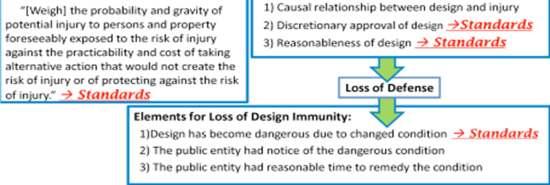
18 Government Immunities Reasonableness Proving the Defense of Reasonableness: Weigh the gravity and probability of the potential injury against the cost of removing the dangerous condition Design Immunity Elements for Defense of Design Immunity: 1) Causal Relationship between design and injury 2) Discretionary approval of the design 3) Reasonableness of design
19 Loss of Immunity Baldwin v. State (1972) 1979 Amendment Bane v. State (1989) Elements for Loss of Design Immunity: 1)Design has become dangerous due to changed condition 2) The public entity had notice of the dangerous condition 3) The public entity had reasonable time to remedy the condition
20 Where there is a dangerous condition of a roadway, design standards can serve an evidentiary function to prove a claim brought under 835 and relevant immunities

21
22 Element How Standards Matter Alternative to Standards Dangerous Condition of a Roadway Reasonableness Defense Design Immunity Defense: Design Approval Noncompliance is evidence of dangerous condition Noncompliance can be unreasonable If no evidence of approval, prevailing design standards show implicit approval -Absence of accident history -Expert testimony -Improved safety -Improved environment -Document approval -Write alternative design standards into local law Design Immunity Defense: Any Substantial Evidence of Reasonableness Loss of Design Immunity: Dangerous Condition due to Changed Condition Noncompliance can be unreasonable Non-compliance is evidence of dangerous condition -Absence of Accident history -Expert testimony -Absence of accident history

23 Elements of Resource Efficient Streets Street trees Cross walks and sidewalks Street width Traffic Calming Conclusion: Case law shows that claims brought under 835 alleging that design elements associated with resource efficient streets are dangerous are rarely successful.

24 1. A city may deviate from prevailing design standards for the sake of developing more resource efficient streets without being vulnerable to liability. 2. A city must take proper steps and precautions when designing and approving a roadway in order to prevent liability. a. Monitor and modify b. Design and document
25 Part Three:
26 Lack of resources Resistance to deviation from common practice Lack of communication between departments Service vehicles Lack of progressive studies and standards The need for security in numbers


27 Context Sensitive Solutions Reforming the Green Book San Francisco s Better Streets Plan
28 Neither laws nor liability are preventing cities from deviating from prevailing design standards in order to develop resource efficient streets.
29 Additional interviews with city planners and engineers to uncover barriers not evident in federal, state, or case law Improving institutional coordination
30 The potential for new manuals to become prevailing standards Identifying funding constraints
31 Developing mechanisms to help cities develop and implement their own street standards Help cities work together to? establish new standards

32 Authors: John Urgo M.C.P UC Berkeley Meredith Wilensky J.D UC Berkeley Steven Weissman Director of the Energy Program Center for Law Energy and the Environment at Berkeley Law
Transportation Research Center
 Increasing Design Flexibility in the AASHTO Green Book Your Department Name Presentation to AASHTO Subcommittee on Design Doug Harwood, MRIGlobal July 2017 Transportation Research Center Resolution of
Chapter 1 - General Design Guidelines CHAPTER 1 GENERAL DESIGN GUIDELINES
 CHAPTER 1 GENERAL DESIGN GUIDELINES 1.0 INTRODUCTION This Publication has been developed to provide current, uniform procedures and guidelines for the application and design of safe, convenient, efficient
Creating Complete Roadway Corridors:
 Creating Complete Roadway Corridors: The AASHTO Guide to Transportation Landscape Architecture and Environmental Design NCHRP Project 15-33 Status Report AASHTO Standing Committee on Design Technical Committee
Clay Street Bridge Replacement Project
 Clay Street Bridge Replacement Project Frequently Asked Questions (FAQs) No. 2 April 4, 2018 The project is located in downtown Placerville on Clay Street between US Highway 50 and Main Street and Cedar
To qualify for federal Transportation Enhancement (TE) funds a project must meet two basic federal requirements:
 funds a project must meet two basic federal requirements:") Eligibility Requirements To qualify for federal Transportation Enhancement (TE) funds a project must meet two basic federal requirements: 1) Relate to surface transportation and 2) Be one of the 12 designated
Eligibility Requirements To qualify for federal Transportation Enhancement (TE) funds a project must meet two basic federal requirements: 1) Relate to surface transportation and 2) Be one of the 12 designated
DESIGN REVIEW COMMITTEE AGENDA ITEM
 DESIGN REVIEW COMMITTEE AGENDA ITEM AGENDA DATE: DECEMBER 16, 2015 TO: THRU: FROM: SUBJECT: Chair McCormick and Members of the Design Review Committee Leslie Aranda Roseberry, Planning Manager Kelly Christensen
REVISED AGENDA MATERIAL
 [First Last name] Councilmember District [District No.] REVISED AGENDA MATERIAL Meeting Date: March 15, 2015 Item Number: 7 Item Description: Adopt a First Reading of an Ordinance Revising BMC 14.48.200
Stewardship. Streamlining. Consensus
 Stewardship Streamlining Consensus Translating Section 106: Building Consensus among Multiple Responsible Parties For the Doyle Drive Replacement Project in the Presidio of San Francisco National Historic
STREETSCAPE MANUAL ONLINE TRAINING SESSION 3: Decision-Making
 TRAINING SESSION 3: The Urban Design Streetscape Manual is a reference tool developed to help implement City policy and guide the design, construction and maintenance of streetscape improvements in Toronto.
TRANSPORTATION AND LAND USE
 CHAPTER 10 TRANSPORTATION AND LAND USE Transportation and land use are intimately linked. The expansion of a highway typically spurs housing, employment growth and land development in the communities that
Transportation Systems and Utility Infrastructure
 77 Audience Local and regional units of government, Landowners and developers, Community and citizen organizations, and Transportation/utility planners and engineers. Overview Transportation systems and
CARVER COUNTY DIVISION OF PUBLIC WORKS LANDSCAPE POLICY. Adopted by the Carver County Board of Commissioners March 3, 2015
 CARVER COUNTY DIVISION OF PUBLIC WORKS LANDSCAPE POLICY Adopted by the Carver County Board of Commissioners March 3, 2015 Policy Statement Goals It is the goal of Carver County Public Works to provide
FDOT D4 Complete Streets
 FDOT D4 Complete Streets Context Sensitive Solutions Directs that complete street solutions will complement the context of the community. Collaborative approach to decision making, project development,
Chapter PEDESTRIAN COMMERCIAL (PC) ZONING DISTRICT
 ZONING DISTRICT") Chapter 11-17 PEDESTRIAN COMMERCIAL (PC) ZONING DISTRICT Sections: 11-17-01 GENERAL PURPOSE 11-17-02 PERMITTED BUILDING TYPES 11-17-03 USES PERMITTED WITH DESIGN REVIEW 11-17-04 USES PERMITTED BY CONDITIONAL
Chapter 11-17 PEDESTRIAN COMMERCIAL (PC) ZONING DISTRICT Sections: 11-17-01 GENERAL PURPOSE 11-17-02 PERMITTED BUILDING TYPES 11-17-03 USES PERMITTED WITH DESIGN REVIEW 11-17-04 USES PERMITTED BY CONDITIONAL
PARKLET PROPOSAL PACKAGE & PROCESS
 500.3 I PARKLETS The term parklet refers to a small temporary constructed seating or community gathering area over an on-street parking space or an extension of the sidewalk into the operating State highway
I voice my concerns with regard to the Mobility Plan, specifically with regard to the following issues and statements in the Plan:
 Adam Lid Council File # 15-0719: Mobility Plan Hearing: 8/4/15: 2:30 PM 1 message RJ STROTZ Reply-To: RJ STROTZ To: "Adam.Lid@lacity.org"
COMPLETE GREEN STREET CHECKLIST
 COMPLETE GREEN STREET CHECKLIST This document was developed to dissect the structure of an urban street and explore opportunities to make our streets more complete while also integrating green street strategies.
Appendix I. Access Management & Land Use Zoning Strategies Memo
 Appendix I ` Access Management & Land Use Zoning Strategies Memo Route 96 Access Management and Land Use/Zoning Strategies The Town of Victor has access management guidelines in Section 5.0 of the 2014
SECTION E. Realizing the Plan
 SECTION E Realizing the Plan 60 DESIGN REGINA - OFFICIAL COMMUNITY PLAN SECTION E Realizing the Plan Design Regina has been an ambitious plan-making exercise, with a high level of community, stakeholder,
Working with Local Government to create Community Gardens
 Working with Local Government to create Community Gardens Zero Waste Local Food Renewable Energy Land Use Energy /Water Efficiency Transit, Bike & Pedestrian Mobility FOOD SECURITY Local Food ENVIRONMENTAL
City of Hermosa Beach Administrative Policy #
 City of Hermosa Beach Administrative Policy # SUBJECT: Living Streets Policy Date: Approved by: City Council Authority: Public Works Department & Community Development Department Mayor, PURPOSE The City
ROANOKE STREET IMPROVEMENTS CHRISTIANSBURG, VIRGINIA VDOT PROJECT # U R24 UPC #:
 ROANOKE STREET IMPROVEMENTS CHRISTIANSBURG, VIRGINIA VDOT PROJECT # U000-154-R24 UPC #: 108868 VICINITY MAP This project is to be constructed in accordance with the Virginia Department of Transportation
Aashto Maintenance Manual For Roadways And Bridges Full Online
 Aashto Maintenance Manual For Roadways And Bridges Full Online We have made it easy for you to find a PDF Ebooks without any digging. And by having access to our ebooks online or by storing it on your
Olde Towne Vision Plan
 Olde Towne Vision Plan Introduction In 2016, the City of Bellevue will complete its move of City offices from Olde Towne Bellevue to its new municipal complex on Wall Street. The City intends to sell its
ITEM #8. Regional Smart Growth Program. Regional Smart Growth Program. Presentation Overview. Coast Highway Vision and Stategic Plan.
 Regional Smart Growth Program Economic Development Commission What is Smart Growth? Adopted as part of the Regional Comprehensive Plan (RCP) RCP provides vision for region based on Smart Growth and sustainability
Access Management: An Overview
 Figures 1-5 Below Evolution of development along a highway. In the early stages, land along the road is used for farming with little traffic generated. As time passes, the highway corridor becomes a de
F. Driveways. Driveways which provide access to off-street parking or loading from public streets shall comply with the following:
 Section 20.945.040 General Design Standards for Surface Parking Areas. A. Review Authority. Parking lot design and drainage shall be subject to review and approval of the City Transportation Manager. B.
TORONTO COMPLETE STREETS GUIDELINES
 TORONTO COMPLETE STREETS GUIDELINES Presentation by Fiona Chapman, Manager, Pedestrian Projects Public Realm Section, Transportation Services, City of Toronto June 2017 PURPOSE OF THE PROJECT To develop
Deputation to Building & Planning Committee November 19, 2012
 Deputation to Building & Planning Committee November 19, 2012 Proposed Rezoning Special Sites 8 and 11 OZ 12/003 W7 Presented by Sharon Giraud, President GWHA executive@gordonwoods.ca Gordon Woods Our
TRANSPORTATION ELEMENT GOALS, OBJECTIVES, AND POLICIES
 TRANSPORTATION ELEMENT GOALS, OBJECTIVES, AND POLICIES GOAL 2 The City shall provide a safe, convenient, effective, and energy efficient multimodal transportation system which is coordinated with the Future
CHAPTER 1. Ms. Guajardo s Class - Central Elementary CH 1 1
 INTRODUCTION CHAPTER 1 Ms. Guajardo s Class - Central Elementary CH 1 1 1.1 SETTING South Centre City is a linear corridor south of Downtown Escondido paralleling Centre City Parkway and South Escondido
Your town s subdivision or land use ordinance standards should reference the following street standards, for example:
 Your town s subdivision or land use ordinance standards should reference the following street standards, for example: Streets shall be designed to move traffic safely and in a way that minimizes environmental
Planning Commission Staff Report June 5, 2008
 Owner/Applicant Taylor Village Sacramento Investments Partners, LP c/o Kim Whitney 1792 Tribute Road #270 Sacramento, CA 95815 Staff Recommendation Planning Commission Staff Report Project: File: Request:
OFFICE CONSOLIDATION SECONDARY PLAN AREA 22 THE BRAMALEA SOUTH INDUSTRIAL SECONDARY PLAN
 OFFICE CONSOLIDATION SECONDARY PLAN AREA 22 THE BRAMALEA SOUTH INDUSTRIAL SECONDARY PLAN November 2010 EXPLANATORY NOTES (Secondary Plan Area 22) General (pertaining to all secondary plan office consolidations)
SCVURPPP Green Infrastructure Handbook. Kristin Kerr, P.E. EOA, Inc. April 19, 2017
 SCVURPPP Green Infrastructure Handbook Kristin Kerr, P.E. EOA, Inc. April 19, 2017 Outline of Presentation Overview Handbook Contents Schedule Overview MRP requires GI Plans to include general guidelines,
Rezoning Issues Setting a Foundation for Zoning Decisions
 Rezoning Issues Setting a Foundation for Zoning Decisions City Council Workshop May 2, 2016 Agenda Goal Need actionable items and sequence of steps Foundation for Zoning Decisions Council Workshop Discussion
A BILL FOR AN ORDINANCE TO AMEND CHAPTER 9, KAUAI COUNTY CODE 1987, RELATING TO STREET REQUIRE:MENTS FOR SUBDIVISIONS
 ORDINANCE NO. BILL NO. { vy"yj1j A BILL FOR AN ORDINANCE TO AMEND CHAPTER 9, KAUAI COUNTY CODE 1987, RELATING TO STREET REQUIRE:MENTS FOR SUBDIVISIONS BE IT ORDAINED BY THE COUNCIL OF THE COUNTY OF KAUA'I,
Design Speed / Target Speed Primer. Jim Rosenow AASHTO Technical Committee on Geometric Design June 12, 2018
 Design Speed / Target Speed Primer Jim Rosenow AASHTO Technical Committee on Geometric Design June 12, 2018 Predecessor research NCHRP Project 15-25 NCHRP Project 15-47 2 Predecessor research NCHRP Project
Community Workshop. City of Richmond. January 25, 2011 SF Bay Trail Connection - Castro St to Richmond-San Rafael Bridge
 Community Workshop City of Richmond 1 City of Richmond Lead Agency BPAC Richmond Community ABAG Design and Process Funding Partner Caltrans Environmental; Process Review Design Process State and Federal
1.0 INTRODUCTION 1.1 TH 14 WEST STUDY AREA Project Description Functional Classification Purpose of the Project
 1.0 INTRODUCTION 1.1 TH 14 WEST STUDY AREA 1.1.1 Project Description The Trunk Highway (TH) 14 West Corridor is a two-lane roadway approximately 22 miles in length. Located in Nicollet County, the corridor
SBCAG STAFF REPORT. MEETING DATE: March 17, 2016 AGENDA ITEM: 5I
 SBCAG STAFF REPORT SUBJECT: Cabrillo-UPRR Bridge Project MEETING DATE: March 17, 2016 AGENDA ITEM: 5I STAFF CONTACT: Fred Luna RECOMMENDATION: Authorize the chair to sign a Memorandum of Understanding
City of Redmond. Urban Holding Area Master Planning Requirements and Approval Process
 City of Redmond Urban Holding Area Master Planning Requirements and Approval Process June 21, 2006 City of Redmond: Urban Holding Area Master Planning Requirements and Approval Process Table of Contents
Berkshire Regional Planning Commission Clearinghouse Review Report
 August 19, 2013 SUBJECT: Reconstruction of Housatonic Street, Dalton, MA EOEA#: 15083 LOCATION: Dalton ESTIMATED COST: $8.1 million REVIEW TYPE: ENF PROPONENT: MassDOT and Town of Dalton COMMENTS DUE:
The Illinois Department of Transportation and Lake County Division of Transportation. Route 173, including the Millburn Bypass
 The Illinois Department of Transportation and Lake County Division of Transportation welcome you to this Public Hearing for U.S. Route 45 from Illinois Route 132 to Illinois Route 173, including the Millburn
ARTICLE 13 STREETS General
 ARTICLE 13 STREETS 13.1 General Streets shall be designed to suit their functions. Many streets have purposes other than vehicular traffic. As an alternative to current N.C. Department of Transportation
Courtice Main Street Study Community Vision Workshop PLANNING SERVICES DEPARTMENT
 Courtice Main Street Study Community Vision Workshop PLANNING SERVICES DEPARTMENT July 22, 2009 Tonight s Meeting 7:00 pm Introduction David Crome, Director of Planning 7:05 Presentation Stasia Bogdan,
ARTICLE 13 STREETS General
 ARTICLE 13 STREETS 13.1 General Streets shall be designed to suit their functions. Many streets have purposes other than vehicular traffic. As an alternative to current N.C. Department of Transportation
CONSENT CALENDAR September 27, 2005
 Office of the Executive Officer September 27, 2005 To: From: Submitted By: Subject: Honorable Chairperson and Members of the Redevelopment Agency Phil Kamlarz, Executive Officer Dan Marks, Director, Planning
Designing INSIDE the Box
 Designing INSIDE the Box Using the ITE/CNU Walkable Urban Thoroughfares Manual to Build Complete Streets National Association of Regional Councils Raleigh, NC June 8, 2015 G. Wade Walker, P.E. Principal
P A R K L E T 2016 PILOT PROJECT
 GRAND FORKS, NORTH DAKOTA P A R K L E T 2016 PILOT PROJECT City of Grand Forks Planning & Community Development Department LIVE, LEARN, WORK, PLAY, AND STAY The purpose of the Grand Forks Parklet Application
Green Book 7 th Edition Summary of Changes. Jim Rosenow NCITE Geometric Design Committee August 30, 2018
 Green Book 7 th Edition Summary of Changes Jim Rosenow NCITE Geometric Design Committee August 30, 2018 Outline 1. The drama 2. Chapter 1 rewrite 3. The rest of the book 2 Outline 1. The drama 2. Chapter
Route 1 Corridor Study
 Route 1 Corridor Study Westbrook, Connecticut A Vision for the Connecticut Shoreline Public Informational Meeting July 28, 2015 Lower Connecticut River Valley Council of Governments Fitzgerald & Halliday,
SPRINGHILL LAKE TRANSIT VILLAGE
 Greenbelt Metro Area Sector Plan - Subarea Design Policies and Guidelines - Springhill Lake Transit Village 113 SPRINGHILL LAKE TRANSIT VILLAGE Residential Neighborhood and Village Center CONCEPT Springhill
City of Fontana Notice of Preparation and Notice of Public Scoping Meeting Fontana North Walmart Project
 Notice of Preparation and Notice of Public Scoping Meeting Fontana North Walmart Project Date: Monday, February 22, 2016 To: From: Subject: Public Agencies and Interested Parties Orlando Hernandez, Senior
Toronto Complete Streets Guidelines
 c. DTAH 58 60 3.1 70 3.2 Performance Measurement 71 3.3 Exceptions Chapter 3 describes the five general steps in the street design process. Not all projects follow these steps, as the number of steps and
2018 Northampton Township Comprehensive Plan
 2018 BUCKS COUNTY, PENNSYLVANIA What is a? A comprehensive plan is a municipality s main policy document that details the collective vision for the future, the historic, environmental, and cultural facilities
Public Hearing. Charlotte County-Punta Gorda MPO - Meeting Rooms A and B March 14, open house at 4 p.m., formal presentation at 5 p.m.
 Public Hearing Charlotte County-Punta Gorda MPO - Meeting Rooms A and B March 14, 2019 open house at 4 p.m., formal presentation at 5 p.m. Welcome to the Public Hearing for the Harborview Road (CR 776)
TRANSPORTATION ELEMENT
 TRANSPORTATION ELEMENT GOAL I: To create and maintain a safe, efficient and aesthetic transportation system that encourages multi-modal transportation and promotes the mobility strategies of the Ocala
SUMMARY OF EVIDENCE OF Neil James Stevens
 LCC19 TOWN AND COUNTRY PLANNING ACT 1990 (AS AMENDED) CONJOINED APPEALS BY CUADRILLA BOWLAND LIMITED AND CUADRILLA ELSWICK LIMITED FOR MONITORING WORKS AND EXPLORATION WORKS AT PRESTON NEW ROAD AND ROSEACRE
TENNESSEE STATE ROUTE 109 CORRIDOR MANAGEMENT AGREEMENT MEMORANDUM OF UNDERSTANDING CORRIDOR MANAGEMENT ALONG STATE ROUTE 109
 TENNESSEE STATE ROUTE 109 CORRIDOR MANAGEMENT AGREEMENT MEMORANDUM OF UNDERSTANDING CORRIDOR MANAGEMENT ALONG STATE ROUTE 109 I. Purpose The purpose of this Agreement is to provide a framework for the
FLORIDA STATE UNIVERSITY MASTER PLAN
 TRANSPORTATION ELEMENT NOTE: Unless otherwise noted, the goals, objectives and policies contained in this element shall guide development on the Tallahassee Campus, Southwest Campus and the Panama City
Designing Walkable Urban Thoroughfares: A Context Sensitive Approach
 Designing Walkable Urban Thoroughfares: A Context Sensitive Approach Communities Want: Flexibility Compatibility with adjacent land uses Balanced land use/transportation functions Safe and attractive streets
Proposed Comprehensive Plan Strategies DRAFT for discussion June 28, 2017
 Proposed Comprehensive Plan Strategies DRAFT for discussion June 28, 2017 Land Use Rural Areas Refine the Farm and Forest area (FF) Update FF boundaries to account for existing lots less than five acres
Toronto Complete Streets Guidelines
 Toronto Complete Streets Guidelines 108 110 7.1 Green Infrastructure Design Principles 112 7.2 Context-Sensitive Green Streets 114 7.3 Key Green Street Elements Green infrastructure refers to natural and
Corporate Report. Further, that Legal Services be directed to prepare the necessary amendments to the City s Delegation By-law.
 Corporate Report Report from Planning and Building Services, Planning Services Date of Report: April 27, 2016 Date of Meeting: May 16, 2016 Report Number: PBS-122-2016 File: 60.2.43 Subject: Expansion
RRW Stonebrook, LLC Tentative Map Findings
 RRW Stonebrook, LLC Tentative Map Findings FINDING T1: The request conforms to the Master Plan and zoning ordinances. RELATIONSHIP TO THE MASTER PLAN 1. The respective development is located within an
CURRICULUM VITAE. James J. Valenta, PE, MSCE, FITE 8463 Shield Road Dexter, MI (734)
") CURRICULUM VITAE James J. Valenta, PE, MSCE, FITE 8463 Shield Road Dexter, MI 48130 (734) 904-2652 Email: jvalenta@prodigy.net Areas of Expertise: Roadway Hydroplaning Analysis, Guardrail, Highway Design,
CURRICULUM VITAE James J. Valenta, PE, MSCE, FITE 8463 Shield Road Dexter, MI 48130 (734) 904-2652 Email: jvalenta@prodigy.net Areas of Expertise: Roadway Hydroplaning Analysis, Guardrail, Highway Design,
Beckett Bridge PD& E Study. Presentation to: Board of County Commissioners
 Beckett Bridge PD& E Study Presentation to: Board of County Commissioners October 22, 2013 Introduction Study Began January 2012 Alternatives Presented to Commission October 2013 Alternatives Presented
What s the role of a Gateway?
 What s the role of a Gateway? A community gateway is like the front door. It provides an introduction. It can express pride and sense of place. A gateway marks the end of one kind of area and the beginning
MEMORANDUM. Jim Tomberlin, Mountain Valley Properties
 MEMORANDUM TO: CC: Jim Tomberlin, Mountain Valley Properties GR Fielding, Pitkin County Engineer Brian Pettit, Pitkin County Public Works Director Dan Cokley, SGM FROM: Lee Barger, SGM DATE: June 16, 2016
BEST PRACTICES FOR PROJECT NOMINATIONS TA Set-Aside Program
 BEST PRACTICES FOR PROJECT NOMINATIONS 2017 TA Set-Aside Program Focus of this presentation Photos Public Support Maps & Exhibits Proposed Budget Design Details Project Evaluation & Selection Criteria
1.0 Purpose of a Secondary Plan for the Masonville Transit Village
 Report to Planning and Environment Committee To: Chair and Members Planning & Environment Committee From: John M. Fleming Managing Director, Planning and City Planner Subject: Masonville Transit Village
P.C. RESOLUTION NO
 P.C. RESOLUTION NO. 08-423 A RESOLUTION OF THE PLANNING COMMISSION OF THE CITY OF CALABASAS TO ADOPT A SIGN PROGRAM (PL0800543) AND APPROVE A VARIANCE (PL0800544) FOR INTERNAL ILLUMINATION OF THE MERCEDES-BENZ
DOWNTOWN JACKSONVILLE MASTER PLAN S T R E E T H I E R A R C H Y
 DOWNTOWN JACKSONVILLE MASTER PLAN S T R E E T H I E R A R C H Y Gateway Intra-District Business Inter-District 44 CELEBRATING THE RIVER: A PLAN FOR DOWNTOWN JACKSONVILLE The Transportation Network This
Rapid City Planning Commission Rezoning Project Report
 Rapid City Planning Commission Rezoning Project Report April 5, 2018 Item # 4 Applicant Request(s) Case # 18RZ008 Rezoning request from General Agricultural District to Low Density Residential District
OVERVIEW OF PLANS FOR THE JEFFERSON COUNTY COUNTRYSIDE FARM In the Context of Quality Place Characteristics
 OVERVIEW OF PLANS FOR THE JEFFERSON COUNTY COUNTRYSIDE FARM In the Context of Quality Place Characteristics By Steve Grabow, Professor and Community Development Educator University of Wisconsin-Extension,
Pennsy Greenway Trail
 Town of Schererville Pennsy Greenway Trail DES. #s: 0401062, 1173595 & 1382661 Construction of Pennsy Greenway Trail beginning at Wilhelm Street and continuing northwest along the former Penn Central railroad
Collaborative Planning:
 Spokane County City of Spokane City of Spokane Valley City of Liberty Lake City of Airway Heights City of Millwood Collaborative Planning: Implementation in Spokane County s Metro Urban Growth Area Appendix
Highway 15 Project - Hutchinson
 Highway 15 Project - Hutchinson Agenda What are we going to talk about today? Goals and benefits of the project Details about the proposed work Project schedule and costs Any questions you may have about
DRAFT MAP AMENDMENT FLU 04-4
 DRAFT MAP AMENDMENT FLU 04-4 SW 24 TH AVENUE ROADWAY CORRIDOR The University of Florida participates with the Metropolitan Transportation Planning Organization (MTPO) in its responsibilities for the continuing,
Transportation Land Use Integration & Regional Planning. Don Kostelec, AICP Senior Planner, Louis Berger Group February 1, 2010
 Transportation Land Use Integration & Regional Planning Don Kostelec, AICP Senior Planner, Louis Berger Group February 1, 2010 Transportation Land Use Integration DOT-HUD-EPA Sustainable Communities Initiative
LOCATION AND DESIGN DIVISION
 VIRGINIA DEPARTMENT OF TRANSPORTATION LOCATION AND DESIGN DIVISION INSTRUCTIONAL AND INFORMATIONAL MEMORANDUM GENERAL SUBJECT: Landscape Architecture Program NUMBER: SPECIFIC SUBJECT: Integration of Landscape
City of Westbrook. 2 York Street Westbrook, Maine (207) Fax:
 Fax:") City of Westbrook DEPARTMENT OF PLANNING & CODE ENFORCEMENT 2 York Street Westbrook, Maine 04092 (207) 854-0638 Fax: 1-866-559-0642 WESTBROOK PLANNING BOARD TUESDAY, JANUARY 2, 2018, 7:00 P.M. WESTBROOK
City of Westbrook DEPARTMENT OF PLANNING & CODE ENFORCEMENT 2 York Street Westbrook, Maine 04092 (207) 854-0638 Fax: 1-866-559-0642 WESTBROOK PLANNING BOARD TUESDAY, JANUARY 2, 2018, 7:00 P.M. WESTBROOK
Iowa s Statewide Urban Design Standards Promote Improved Access Management
 Iowa s Statewide Urban Design Standards Promote Improved Access Management David J. Plazak and Dale S. Harrington Center for Transportation Research and Education Iowa State University 2901 South Loop
Coast Highway Oceanside, California
 Coast Highway Oceanside, California Coast Highway Plan Zones What We ve Heard - Walkable/Bikeable Community (Senior and Child Friendly) -Wider Sidewalks -Street Trees -Traffic Calming -Bike Lanes -Paseos
Onondaga County Sustainable Streets Project. Onondaga County Planning Federation June 7, Onondaga County Sustainable Streets Project 1
 Onondaga County Sustainable Streets Project Onondaga County Planning Federation June 7, 2012 Onondaga County Sustainable Streets Project 1 Sustainable Streets 1. Introduction to the SMTC 2. Sustainable
Chain Bridge Road Sidewalk Improvements Citizen Council Work Session
 Chain Bridge Road Sidewalk Improvements Citizen Council Work Session May 10, 2016 Project Location 2 Project Objectives Provide a continuous pedestrian facility (sidewalk) connection from Downtown City
THE CITY OF VAUGHAN BY-LAW BY-LAW NUMBER
 THE CITY OF VAUGHAN BY-LAW BY-LAW NUMBER 123-2013 A By-law to designate the whole of the City of Vaughan as a Site Plan Control Area, and to adopt site development guidelines and rules of procedure for
5.0 IMPLEMENTATION STRATEGIES
 5.0 IMPLEMENTATION STRATEGIES 5.1 Recommended Alternative This chapter discusses the anticipated steps needed to move each project from recommendation to construction. Since full funding for these alternatives
Green Stormwater Infrastructure Handbook. Kristin Kerr, P.E. EOA / SCVURPPP November 29, 2018
 Green Stormwater Infrastructure Handbook Kristin Kerr, P.E. EOA / SCVURPPP November 29, 2018 Outline of Presentation Overview Handbook Contents Example Details Overview MRP requires GSI Plans to include
What s New in Roundabout Design?
 Roundabouts: An Informational Guide, 2 nd ed. What s New in Roundabout Design? National and State Perspective Brian Walsh, WSDOT Lee Rodegerdts, Kittelson & Associates, Inc. Overview & Philosophy Chapter-by-Chapter
Town of Weston Guardrail Overview Report
 Town of Weston Guardrail Overview Report July 28, 2016 Prepared for: Town of Weston Weston, MA 02493 Submitted by: Nitsch Engineering 2 Center Plaza, Suite 430 Boston, MA 02108 Nitsch Engineering Project
Q:%4~ Memorandum CITY OF DALLAS
 Memorandum DATE December 10, 2010 CITY OF DALLAS TO Members of the Transportation and Environment Committee: Linda Koop (Chair), Sheflie Kadane (Vice Chair), Pauline Medrano, Vonciel Jones Hill, Jerry
Francis Chen. urban planning & design portfolio
 Francis Chen urban planning & design portfolio TABLE OF CONTENTS MADISON PARK OAKLAND, CA Urban Design & Cultural Activity Mapping 01: MADISON PARK 02: WEST WALNUT CREEK DOWNTOWN SPECIFIC PLAN 03: BIKE-SHARE
INTRODUCTION EXISTING CONDITIONS
 INTRODUCTION The Pedestrian Mobility Study and Plan is a Transportation Planning effort to identify Safe Mobility Alternatives for Pedestrian and Bicycle traffic within the City of Port Aransas. This plan
2. MULTI-MODAL TRANSPORTATION ELEMENT Goals, Objectives, and Policies
 2. Goals, Objectives, and Policies GOAL 2-1: TO INTEGRATE THE MULTI-MODALTRANSPORTATION SYSTEM WITH THE FUTURE LAND USE ELEMENT, THE FUTURE LAND USE MAP, ANDTHE LAND DEVELOPMENT CODE TO GUIDE DEVELOPMENT
PROP. 84 REMOVING BARRIERS TO LID: MUNICIPAL CODE UPDATE ASSISTANCE CASE STUDY: CODE UPDATES IN ARCATA
 PROP. 84 REMOVING BARRIERS TO LID: MUNICIPAL CODE UPDATE ASSISTANCE CASE STUDY: CODE UPDATES IN ARCATA OCTOBER 7, 2015 CASE STUDY: CODE UPDATES IN ARCATA Arcata is a city located in Humboldt County immediately
Division Street in Portland. Division Green Street / Main Street
 Division Green Street / Main Street Division Street in Portland Putting People in the Process Division Corridor Concept Emphasis on Sustainability and Green development Division Corridor Concept Reuniting
Public Works Project Delivery Report
 Public Works Project Delivery Report May 2017 San Gabriel Public Works delivers reliable infrastructure & welcoming public spaces by designing, constructing, operating & maintaining the City s streets,
Metro 2010 Pedestrian Symposium Walking into the Future City
 Metro 2010 Pedestrian Symposium Walking into the Future City John Kaliski, AIA, May 12, 2010 How can our transportation and land use policies create complete streets for all users? How do we optimize the