Francis Chen. urban planning & design portfolio
|
|
|
- Ezra Andrews
- 6 years ago
- Views:
Transcription


1 Francis Chen urban planning & design portfolio


2 TABLE OF CONTENTS MADISON PARK OAKLAND, CA Urban Design & Cultural Activity Mapping 01: MADISON PARK 02: WEST WALNUT CREEK DOWNTOWN SPECIFIC PLAN 03: BIKE-SHARE STATIONS IN SAN FRANCISCO 04: CALIFORNIA GREEN TECHNOLOGY PARK source of photos: Francis Chen, Iris Corey In the process of developing the Lake Merritt BART Station Specific Plan, the City of Oakland and BART decided to choose Madison Park as a potential space for mixed-used redevelopment, given its close proximity to the BART station. However, the elderly who use the park every morning for physical exercise and socializing: their voices were not being represented in Oakland Chinatown. Our role: map physical and cultural activities in the park throughout a weekday morning, and create a 3D Google SketchUp model of future urban design guidelines of the park, based on interviews with key stakeholders of the park. These visualizations served as tools for the elderly to show to city planning officials that the park is an important cultural asset to the community that should be protected and preserved for future use. As a result of a public exhibit, BART Director Robert Raburn convinced planning staff to keep the park from redevelopment.


")

3 cultural activity map using GIS mapping physical and cultural activity, based on several observations during weekday mornings birds eye view of park, with proposed improvements to meet needs of future residents near transit development proposed seating space with trees, seating, and a improved playstructure to attract neighborhood children I created the map using ArcGIS pan view of park in the morning, with qi gong exercise in the background. The amount of empty space in the park makes the park underutlized in the afternoon, which lead us to make the 3D Google SketchUp model (see next pg) proposed gazebo. purpose: provide a performance space, seating and shade I worked with an architecture student. I built the gazebo, place the playground as well as built the restroom.


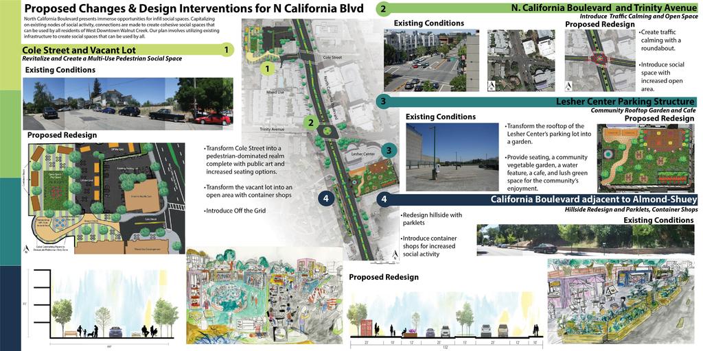
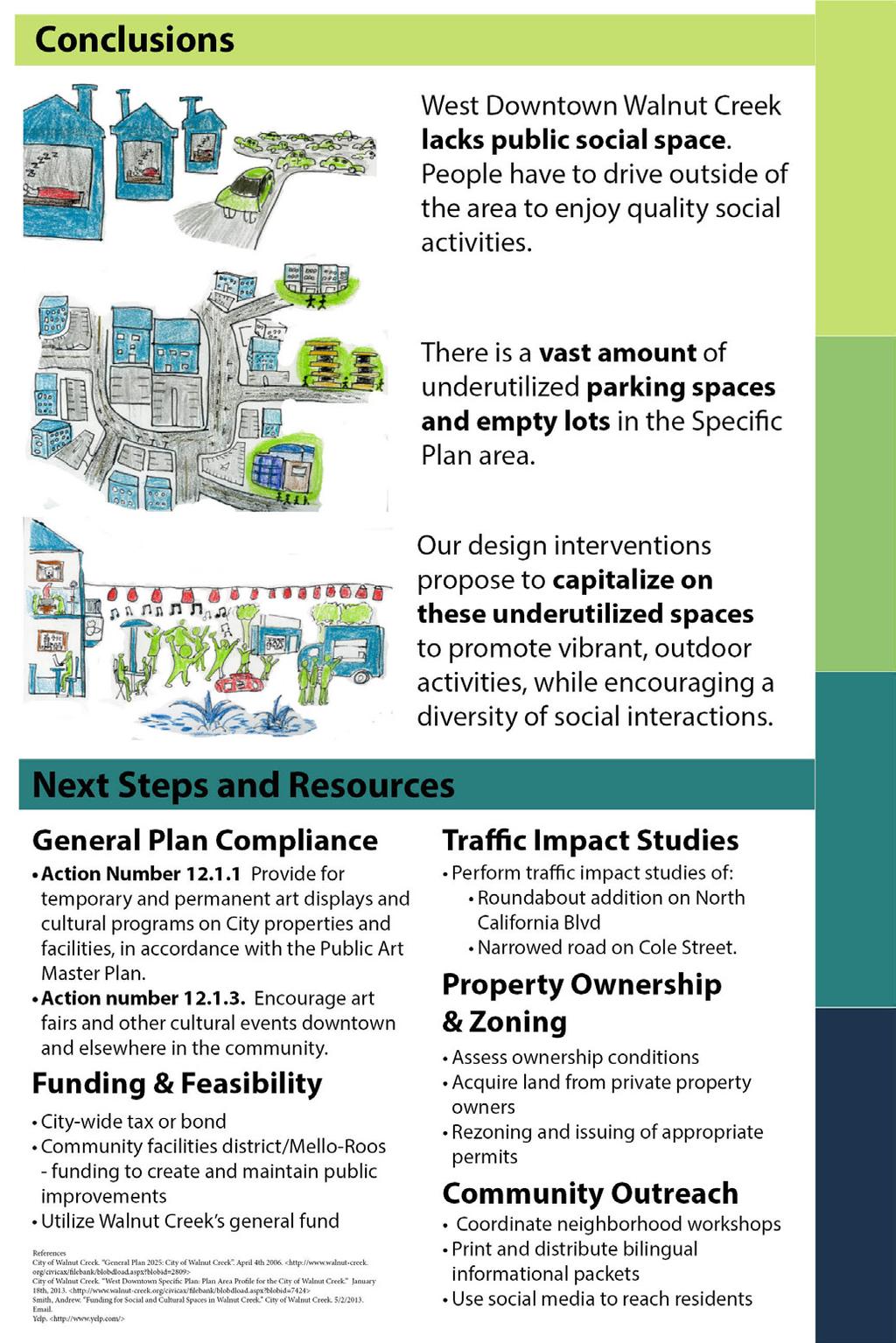
4 WEST DOWNTOWN WALNUT CREEK SPECIFIC PLAN Undergraduate Urban Planning Studio, UC Berkeley The West Walnut Creek Downtown Specific Area suffers from a lack of community gathering spaces, public spaces, and parks, restaurants, as well as social/cultural activities that can cater to the local community. Given the large percentage of space dedicated to the automobile, such as parking lots or asphalt for roads/streets, our class was assigned to develop proposals that could help improve the area in the next twenty to thirty years. Our role: perform background research of the West Walnut Creek Downtown Area, do site analysis of exisiting conditions, and prepare proposals for improvements in the general area to City of Walnut Creek staff and urban planning staff.


5 site analysis of social and cultural activites in West Walnut Creek Specific Plan Area note: the proposal stage is still in progress
6


7 WHERE SHOULD I PUT BIKE SHARE STOPS? SAN FRANCISCO, CA Geographic Informations Systems Course Final Project photo credits to wikipedia For our final project, our role was to create a bikeshare suitability map using ArcGIS identifying the best locations to place bike sharing stops in the City of San Francisco. By identifying elements such as land use, access to transit, density, traffic safety, proximity to bicycle lanes, elevation, and traffic speed limit, I mapped these elements, numerically weighed the positives and negatives of each element, and identified the best location to put bike sharing maps: this is my suitablity map (see left map on next page) Next (see right map on next page), I created a map of key activity sites of locations in San Francisco such as neighborhood commercial centers, banks, transit stops, or farmers markets to compare with my suitability map. This helps me predict the success of potential bike sharing stations. I discovered that the best locations would be in the Downtown San Francisco area, as well as the Mission District.
 General Adminsitration Incubator Solar Panels Finance Center Logistics Center")


8 CALIFORNIA GREEN TECHNOLOGY PARK FREMONT, CA Graphic Illustration, Mapping, Planning Intern California Green Technology Park (in Silicon Valley) General Adminsitration Incubator Solar Panels Finance Center Logistics Center Convention Center Job Training Center Electric Vehicle LED Lighting Energy Storage Draft Version The City of Fremont, located within the heart of Silicon Valley, is striving to attract Chinese clean tech industries into what will become California s first green tech industrial park. Industries that the park is trying to cater to include the solar panel, electric vehicle, LED lighting, as ell as energy storage industries. The goal of this park is to promote Joint Chinese & American collaboration and combining the resources and innovation of each side to create a successful clean tech park. Working with the State of California Comissioner of Economic Development Henry Yin, my role is to create graphic illustrations to help visually communicate and articulate the Green Technology Park between different stakeholders. For example, the maps above have already been shown to Mainland Chinese clean tech companies to attract investment into the green park, as well as the Chinese Instiute of Engineers in Silicon Valley. Francis Chen fncis.chen@gmail.com phone: skype: fncischen University of California, Berkeley Bachelor of Arts, Urban Studies (2013)
The Role of Cities in Planning Transportation Megaprojects
 The Role of Cities in Planning Transportation Megaprojects SPUR Oakland, November 28, 2018 + Elizabeth Deakin / UC Berkeley + Eric Eidlin / City of San Jose + Doug Johnson / City of San Francisco The Role
1 October Dear Citizens of Charlotte and Mecklenburg County,
 1 October 2011 Dear Citizens of Charlotte and Mecklenburg County, As co-chairs of the Center City 2020 Vision Plan Steering Committee, we are proud to present the Center City 2020 Vision Plan, which sets
Savannah (Shao-Wei) Wu. Design Portfolio
 Wu. Design Portfolio") Savannah (Shao-Wei) Wu Design Portfolio Envisioning SOMA in 2050 July August 2016 (5 weeks) U.C. Berkeley CED Design & Innovation for Sustainable Cities Site South of Market Street (SOMA), San Francisco,
Savannah (Shao-Wei) Wu Design Portfolio Envisioning SOMA in 2050 July August 2016 (5 weeks) U.C. Berkeley CED Design & Innovation for Sustainable Cities Site South of Market Street (SOMA), San Francisco,
CHAPTER 3 VISION, GOALS, & PLANNING PRINCIPLES. City of Greensburg Comprehensive Plan. Introduction. Vision Statement. Growth Management Goals.
 CHAPTER 3 VISION, GOALS, & PLANNING PRINCIPLES Introduction The Greensburg Comprehensive Plan is intended as a working community document. A combination of long and short-term goals, this document is intended
CHAPTER 7: Transportation, Mobility and Circulation
 AGLE AREA COMMUNITY Plan CHAPTER 7 CHAPTER 7: Transportation, Mobility and Circulation Transportation, Mobility and Circulation The purpose of the Transportation, Mobility and Circulation Chapter is to
Sustainability, Health, Safety, Recreation & Open Space Working Group August 3, 2017
 Sustainability, Health, Safety, Recreation & Open Space Working Group August 3, 2017 DOWNTOWN OAKLAND SPECIFIC PLAN WELCOME Sustainability, Health, Safety, Recreation & Open Space Working Group Social
Discussion Questions - Summary. 1. What do you value most about the area and think needs to be preserved by the Plan?
 Community Meeting #1 Discussion Questions - Summary 1. What do you value most about the area and think needs to be preserved by the Plan? Architectural Retain character through preservation of historical
APN#: Lot Size: ±5,625 SF. Vacant corner lot. Current Height Limit: 70 FT. Current Zoning: CB - Central Business District
 900 MacDonald Avenue Richmond, CA 900 MacDonald Avenue Richmond Berkeley Features APN#: 538-260-001-2 Lot Size: ±5,625 SF Vacant corner lot Current Height Limit: 70 FT Current Zoning: CB - Central Business
Transportation Working Team Duane Diggs, Co-Chair (VOICE Buffalo) Kelly Dixon, Co-Chair (GBNRTC) Paul Ray, Facilitator (UB Regional Institute)
 Kelly Dixon, Co-Chair (GBNRTC) Paul Ray, Facilitator (UB Regional Institute)") towards a more sustainable Buffalo Niagara Transportation Working Team Duane Diggs, Co-Chair (VOICE Buffalo) Kelly Dixon, Co-Chair (GBNRTC) Paul Ray, Facilitator (UB Regional Institute) Agenda Welcome,
towards a more sustainable Buffalo Niagara Transportation Working Team Duane Diggs, Co-Chair (VOICE Buffalo) Kelly Dixon, Co-Chair (GBNRTC) Paul Ray, Facilitator (UB Regional Institute) Agenda Welcome,
Isabel Neighborhood Plan: Alternatives
 Isabel Neighborhood Plan: Alternatives Presented by: Lori Parks, Associate Planner February 2, 2015 Agenda 1. Background on BART to Livermore 2. Isabel Neighborhood Plan 3. Alternative Scenarios 4. General
Jamie Li 513 Beacon Street, Apt #6 Boston, MA
 Jamie Li 513 Beacon Street, Apt #6 Boston, MA 02215 jamie.li@the-bac.edu 617.595.3245 Education Boston Architectural College, Boston, MA Candidate for Master s of Architecture Program August 2012 - Present
CITY OF UNION CITY MINUTES GENERAL PLAN ADVISORY COMMITTEE
 CITY OF UNION CITY MINUTES GENERAL PLAN ADVISORY COMMITTEE WEDNESDAY, MARCH 4, 2015, 6:30 P.M. IN THE CITY COUNCIL CONFERENCE ROOM OF CITY HALL 34009 ALVARADO-NILES BLVD., UNION CITY, CALIFORNIA Attachment
4- PA - LD - LIVELY DOWNTOWN. LD - Background
 4- PA - LD - LIVELY DOWNTOWN LD - Background The downtown has been the service centre for the community since the city s inception and the area continues to supply people with their personal services,
Affordability & Equity
 Affordability & Equity 1. Impact Fees 2. Displacement Prevention- build more housing to meet growth demands 3. Density Bonuses 4. Regional Housing Bond 5. Stricter Condominium Conversion Laws 6. Vacant
Introduction and Overview
 Introduction and Overview Articulate local values and priorities Guide land use and development decisions Coordinate transportation, infrastructure, and City services with expected growth and available
TOWN COUNCIL / PLANNING COMMISSION
 Workshop #3 TOWN COUNCIL / PLANNING COMMISSION January 20, 2011 Consultant Team In Attendance Tonight BMS Design Group Nevada City and San Francisco Michael Smiley, AICP, ASLA Partner-in-Charge Nancy L.
Jordan Harrison, Planner III, San Francisco Recreation and Park Department
 Date December 8, 2015 To: Through: From: Subject: Recreation and Park Commission Philip A. Ginsburg, General Manager Dawn Kamalanathan, Director, Capital & Planning Division Jordan Harrison, Planner III,
Horizon 2035 Land Use and Transportation Element
 CITY OF SUNNYVALE Horizon 2035 Land Use and Transportation Element City Council Study Session March 7, 2017 Overview General Plan Context Mixed Use Villages Transportation Mode & Parking General Plan Policy
REGIONAL ACTIVITY CENTER
 DRAFT REGIONAL ACTIVITY CENTER 70 EAST BENCH MASTER PLAN DRAFT 06 Introduction The East Bench Regional Activity center is comprised of large educational, research, medical, and employment centers. These
AREA-WIDE PEDESTRIAN AND BICYCLE CIRCULATION
 OUSD LANEY CHILD CARE CENTER ART BUILDING LANEY COLLEGE BALL FIELDS PCCD OFFICES PERALTA PARK AQUATIC CENTER & ESTUARY PARK EDOFF MEMORIAL BANDSTAND SNOW PARK COURT HOUSE OAKLAND MUSEUM OAK ST AREA-WIDE
CENTRAL ESTUARY PLAN AVISION FOR OAKLAND S WATERFRONT
 Central Estuary Plan A VISION FOR OAKLAND S WATERFRONT Specific Plan and Environmental Assessment Presentation to the Parks and Recreation Advisory Commission December 9, 2009 This Afternoon s Presentation
9/19/2018 TODAY S WEBINAR AGENDA CONTINUING EDUCATION UPCOMING TRAINING FROM APBP
 TODAY S WEBINAR AGENDA 3:00 pm: Introduction 3:05 pm: Presentation 3:45 pm: Questions 4:00 pm: Webinar Ends For technical assistance during the webinar: 1-800-263-6317 Choose these prompts: 1, 1, 1 CONTINUING
REVISED AGENDA MATERIAL
 [First Last name] Councilmember District [District No.] REVISED AGENDA MATERIAL Meeting Date: March 15, 2015 Item Number: 7 Item Description: Adopt a First Reading of an Ordinance Revising BMC 14.48.200
Sprawling urban development and auto-dominated streets
 Neighborhood-Scale Planning Tools to Create Active, Livable Communities Sprawling urban development and auto-dominated streets make it nearly impossible for people to integrate walking or bicycling into
Design your Ideal City. Adrian A.-A.
 Design your Ideal City Adrian A.-A. My Vision I would love to create a city with a futuristic downtown with high rises and skyscrapers while staying environmentally friendly. As a coastal city on a large
2014 Exhibition of School Planning and Architecture. White Hill Middle School Campus Master Plan & Design. Ross Valley School District Fairfax, CA
 2014 Exhibition of School Planning and Architecture White Hill Middle School Campus Master Plan & Design Ross Valley School District Fairfax, CA Main Exterior Image Main Exterior Image Main Site Diagram
Chapter 4. Linking Land Use with Transportation. Chapter 4
 Chapter 4 Linking Land Use with Transportation Chapter 4 59 Chapter 4 Linking Land Use with Transportation Community Design and Transportation Program Introduction Since the 1950s, the predominant development
Streets, Connectivity & Built Environment Working Group August 2, 2017
 Streets, Connectivity & Built Environment Working Group August 2, 2017 DOWNTOWN OAKLAND SPECIFIC PLAN WELCOME Streets, Connectivity & Built Environment Working Group Social Equity Meeting August 2, 2017
Honorable Mayor and Members of the City Council. Submitted by: Eric Angstadt, Director, Planning and Development
 Office of the City Manager ACTION CALENDAR January 29, 2013 To: From: Honorable Mayor and Members of the City Council Christine Daniel, City Manager Submitted by: Eric Angstadt, Director, Planning and
Coast Highway Oceanside, California
 Coast Highway Oceanside, California Coast Highway Plan Zones What We ve Heard - Walkable/Bikeable Community (Senior and Child Friendly) -Wider Sidewalks -Street Trees -Traffic Calming -Bike Lanes -Paseos
Presenting a Vision for Thread Lake
 Presenting a Vision for Thread Lake FEBRUARY 20, 2014 SPECIAL THANKS TO: International Academy of Flint Flint River Watershed Coalition South Saginaw Business and Resident Association South Side Neighborhood
Onondaga County Sustainable Streets Project. Onondaga County Planning Federation June 7, Onondaga County Sustainable Streets Project 1
 Onondaga County Sustainable Streets Project Onondaga County Planning Federation June 7, 2012 Onondaga County Sustainable Streets Project 1 Sustainable Streets 1. Introduction to the SMTC 2. Sustainable
Increase density to meet housing and affordability goals and to support transit investments.
 Topic Issues Community & Plan Alternatives Ideas Built Environment 1 - Adapt and grow downtown's capacity for a vibrant mix of jobs, housing and other uses to meet the needs of existing residents and the
UNIVERSITY OF TEXAS BRACKENRIDGE TRACT THE TEAM
 UNIVERSITY OF TEXAS BRACKENRIDGE TRACT THE TEAM 1 JOHNSON FAIN / OLIN PARTNERSHIP Master Planning + Land Use Planning + Urban Design + Landscape Architecture TANIGUCHI ARCHITECTS Design Consultant + Public
DOWNTOWN AREA PLAN. June 9, 2009
 DOWNTOWN AREA PLAN June 9, 2009 Issues Identified by Councilmembers Overlap with Southside Plan Southwest Residential Area & Herrick Shadows & Residential Areas Shadows on Streets & Canyon Effect Transit
Table of Contents. Executive Summary... vii
 Table of Contents Executive Summary... vii Section I: Background...1 Introduction... 3 Study History... 3 Purpose and Role of the Plan... 6 Plan Organization... 7 The Estuary Shoreline... 11 Multiple Jurisdictions...
Downtown Davis Specific Plan
 Downtown Davis Specific Plan Dana Point, CA Existing Conditions Presentation Daniel Parolek Principal, Opticos Design, Inc. Mitali Ganguly Associate, Opticos Design, Inc. January 25, 2018 1 All Places
Seeking Restaurant / Retail For Total Of 6,767 SF Adjacent to UC Berkeley, High Foot Traffic
 Exclusive Lis ng Agent: John Polyzoides john.polyzoides@srsre.com 415.908.4939 CA Lic: 01942201 415.908.4930 Description The new David Blackwell Hall is ideally situated one block from Berkeley s busiest
CHAPTER 1. Ms. Guajardo s Class - Central Elementary CH 1 1
 INTRODUCTION CHAPTER 1 Ms. Guajardo s Class - Central Elementary CH 1 1 1.1 SETTING South Centre City is a linear corridor south of Downtown Escondido paralleling Centre City Parkway and South Escondido
DRAFT Land Use Chapter
 Stevens Creek Urban Village DRAFT 1 18 17 Land Use Chapter INTRODUCTION This Land Use Chapter describes how the Stevens Creek Urban Village will accommodate the growth that is planned for it in the Envision
THEMES, VISION, + PRINCIPLES
 CHAPTER 2: THEMES, VISION, + PRINCIPLES This page intentionally left blank. 20 VISION DRAFT AUGUST 2018 2 2 THEMES, VISION, + GUIDING PRINCIPLES The Key Themes, Vision, and Guiding Principles presented
Ryoko Iizuka Finance, Economics and Urban Department
 THE WORLD BANK www.worldbank.org/eco2 Eco 2 Cities Guide Ryoko Iizuka Finance, Economics and Urban Department 09.12.2011 1 Challenge: How? The 350 page Eco 2 Book elaborates on the principles, methods
PRINCIPLE 6: Preserve open space, farmland, natural beauty, and critical environmental areas
 HOW TO APPLY SMART GROWTH PRINCIPLES TO RURAL COMMUNITIES PRINCIPLE 6: Preserve open space, farmland, natural beauty, and critical environmental areas A product of AND A cooperative publication from the
tinyan lee the hastings experience masterplan : hastings corridor individual design sustainable urbanism : the hastings corridor
 tinyan lee the hastings experience masterplan : hastings corridor individual design Research Context Managing urban growth in Burnaby has become an increasing challenge. Burnaby currently has an estimated
Making Transit Oriented Development Work For Boonton, NJ
 Making Transit Oriented Development Work For Boonton, NJ Bloustein School of Planning and Public Policy Studio Dan Burton Loannie Dao Webster Slater Brandon Williams Ian Watson Maria Laham Nicola Mammes
EXISTING COMPREHENSIVE PLAN
 EXISTING COMPREHENSIVE PLAN Town Center Land Use Element: V. LAND USE POLICIES Town Center Mercer Island's business district vision as described in "Your Mercer Island Citizen-Designed Downtown" was an
Food Innovation Districts An Economic Gardening Tool. Patty Cantrell Sarah Lucas Lakes to Land November 14, 2012
 Food Innovation Districts An Economic Gardening Tool Patty Cantrell Sarah Lucas Lakes to Land November 14, 2012 Provide services to local governments in 10-county region Planning master plans, recreation
PRINCIPLE 8: Provide a variety of transportation choices
 HOW TO APPLY SMART GROWTH PRINCIPLES TO RURAL COMMUNITIES PRINCIPLE 8: Provide a variety of transportation choices A product of AND A cooperative publication from the Stennis Institute of Government and
A Context-Based Design Code for Pedestrian & Transit-Oriented Development RAIL~VOLUTION NOVEMBER 2006
 A Context-Based Design Code for Pedestrian & Transit-Oriented Development RAIL~VOLUTION NOVEMBER 2006 Palo Alto Zoning Ordinance Update. Project Overview City of Palo Alto Palo Alto Zoning Ordinance Update.
WEST OAKLAND SPECIFIC PLAN Final Plan. 2. Vision & Goals. 2.1 Community-Based Goals and Objectives
 WEST OAKLAND SPECIFIC PLAN Final Plan 2. Vision & Goals 2.1 Community-Based Goals and Objectives June 2014 2: Vision & Goals The vision of the West Oakland Specific Plan is to see this remarkable community
Proposed Land Use Concept
 Proposed Land Use Concept Proposed Land Use Concept Change Areas Proposed Land Use Concept Key Features Consolidate auto sales and services north of Ygnacio Valley Rd, with a more compact footprint Facilitate
SAN RAFAEL GENERAL PLAN 2040 INTRODUCTION AND OVERVIEW
 SAN RAFAEL GENERAL PLAN 2040 INTRODUCTION AND OVERVIEW Steering Committee Presentation February 14, 2018 Purpose of General Plan Guide land use and development decisions Coordinate transportation, infrastructure,
JIANHUACHEN LA 2111L SPTIAL DESIGN LABORATARY LANDSCAPE ARCHITECTURE DESIGN PROCESS PORTFOLIO
 JIANHUACHEN LA 2111L SPTIAL DESIGN LABORATARY LANDSCAPE ARCHITECTURE DESIGN PROCESS PORTFOLIO URBAN OASIS CONCEPT DESCRIPTION: Urban oasis is a public open space, park, or plaza which is located in between
Creating Quality Places: Successful Communities by Design
 Creating Quality Places: Successful Communities by Design Communities across the metropolitan Kansas City area are growing. Our challenge is to shape future development in ways that will maintain and enhance
Diridon Station Area: Framework for Implementation
 Diridon Station Area: Framework for Implementation LAND USE MISSION: The Diridon Station Area is the most significant opportunity for placemaking in San Jose. Development should integrate and expand into
Lehigh Acres Land Development Regulations Community Planning Project
 Lehigh Acres Land Development Regulations Planning Effort Summary In July, 2010 Commissioner Frank Mann invited the Lehigh Acres community to start discussing how to achieve their recently adopted community
include playgrounds, sports fields, community gardens and picnic areas.
 DEVELOPMENT PLAN OPEN SPACE SYSTEM OPEN SPACE SYSTEM The neighborhood provides for a range of open space types. The Village Square is an important open space in the neighborhood. It serves as a gathering
City of Hopkins 2012 Mission and Goals
 City of Hopkins 2012 Mission and Goals Mission Statement Partnering with the community to enhance the quality of life by Inspiring Educating Involving Communicating Collaborative with School District Overcoming
Industrial Corridor Modernization Little Village
 Industrial Corridor Modernization Little Village Rahm Emanuel, Mayor David Reifman, Commissioner Dept. of Planning and Development Working Group April 26, 2018 dpd@cityofchicago.org cityofchicago.org/dpd
New Rochelle Arts + Cultural District Master Plan Conceptual Plan. February 4, 2015
 New Rochelle Arts + Cultural District Master Plan Conceptual Plan February 4, 2015 Arts Districts What s It All About? What is an Arts + Cultural District? Designated area Set of policies that support
CIVIC CENTER PUBLIC REALM PLAN OVERVIEW
 Photo Credit: Blake Marvin. CIVIC CENTER PUBLIC REALM PLAN OVERVIEW PLANNING COMMISSION JANUARY 28, 2016 CIVIC CENTER PUBLIC REALM PLAN PRESENTATION OVERVIEW 1. Introduction 2. Planning History 3. Design
ABOUT GREEN CITY PROGRAM:
 ABOUT GREEN CITY PROGRAM: Green City Program Engaging, inspiring and empowering our youth for a sustainable future. Green City teaches K-12 students about environmentally sustainable design as it pertains
Park Marina Area Concept Plan: Riverfront Revitalization in Redding, CA
 Focus Volume 3 Issue 1 Focus 3 Article 16 4-2006 Park Marina Area Concept Plan: Riverfront Revitalization in Redding, CA Sean Nicholas California Polytechnic State University - San Luis Obispo Vicente
2. Form and Character. 2.1 Introduction. 2.2 The Downtown Addition Plan. 2.1 Introduction
 2.1 Introduction 2.1 Introduction This section of the Specific Plan describes and illustrates the desired form, character and uses of the Downtown Addition and explains the underlying design principles.
Small Area Plan. South Gateway
 Small Area Plan Adopted May 12, 2008 South Gateway Purpose. The South Gateway Small Area Plan defines the City s expectations for the future of the southern entrance to the City at Interstate 85 and Highway
4.1.3 LAND USE CATEGORIES
 4.1.3 LAND USE CATEGORIES a. City Center District The City Center District incorporates the existing character and mix of uses in downtown Belmont to encourage redevelopment and new development in keeping
ICLEI Webinar Sustainability in the Master Plan and Zoning Code
 ICLEI Webinar Sustainability in the Master Plan and Zoning Code Sustainability in Grand Rapids 2000 2002 New Master Plan 2004 2005 Neighborhood Pattern Workbook 2006 2007 Form-Based Zoning Ordinance 2007
Walnut Creek BART Station
 Walnut Creek BART Station Mixed Use Transit Oriented Project Design Review Commission Study Session May 17, 2006 Applicant: Walnut Creek Transit Lifestyles Associates Joint Venture: Transit Village Associates
This Review Is Divided Into Two Phases:
 Semiahmoo Town Centre Review The purpose of this review: To review the Semiahmoo Town Centre Concept Plan, originally approved in 1993, to ensure that this centre will continue to serve the needs of South
Pismo Beach Downtown Strategic Plan. Greetings from
 Greetings from Hearing Draft - May 2014 Acknowledgments Town Council Shelly Higginbotham Mayor Edward Waage Mayor Pro Tem Erik Howell Council Member Mary Ann Reiss Council Member Kris Vardas Council Member
Denton. A. Downtown Task Force
 2 Public Involvement Early and ongoing public involvement was solicited so that the public had ample opportunity to help direct the DTIP s concepts and implementation strategies. The residents of Denton
North Downtown Specific Plan MEMORANDUM
 North Downtown Specific Plan MEMORANDUM MEETING DATE: November 13, 2017 TO: Members of the North Downtown Specific Plan Advisory Committee FROM: Jeanine Cavalli, Senior Planner SUBJECT: Materials for the
Subregion 4 Central Avenue-Metro Blue Line Corridor Transit-Oriented Development (TOD) Implementation Project. Community Meeting April 27, 2011
 Implementation Project. Community Meeting April 27, 2011") Subregion 4 Central Avenue-Metro Blue Line Corridor Transit-Oriented Development (TOD) Implementation Project Community Meeting April 27, 2011 Overview Introduction to Subregion 4 TOD Implementation Program
Subregion 4 Central Avenue-Metro Blue Line Corridor Transit-Oriented Development (TOD) Implementation Project Community Meeting April 27, 2011 Overview Introduction to Subregion 4 TOD Implementation Program
PIKE PINE RENAISSANCE: ACT ONE. October 19, 2017
 PIKE PINE RENAISSANCE: ACT ONE October 19, 2017 WATERFRONT SEATTLE PROGRAM PROJECT INTRODUCTION Pike and Pine streets, between First and Melrose avenues Pedestrian and streetscape improvements Budget:
Health and the Built Environment Placemaking Workshop, February 2018
 Health and the Built Environment Placemaking Workshop, February 2018 Vermont Department of Health Suzanne Kelley; Healthy Communities Program Coordinator Vision: Healthy People in Healthy Communities As
URBAN DESIGN --DATA SHEET
 URBAN DESIGN --DATA SHEET What Is Urban Design? Urban Design is the study of the relationship among the components within a city and of the development of a design plan which will improve the quality of
ULI Boston Technical Assistance Panel (TAP) Program. Downtown Marlborough
 Program. Downtown Marlborough") ULI Boston Technical Assistance Panel (TAP) Program Downtown Marlborough ULI the Urban Land Institute Mission To provide leadership in the responsible use of land and in creating and sustaining thriving
ULI Boston Technical Assistance Panel (TAP) Program Downtown Marlborough ULI the Urban Land Institute Mission To provide leadership in the responsible use of land and in creating and sustaining thriving
Transit / Housing Oriented Redevelopment
 Broward County Urban Planning and Redevelopment Department Kick-Off Meeting October 24, 2007 Transit / Housing Oriented Redevelopment 1 Future Land Use 2 Broward County Charter Voters approved in 1974.
Exploiting Transit s City Shaping Powers Robert Cervero University of California, Berkeley
 Exploiting Transit s City Shaping Powers Robert Cervero University of California, Berkeley Session on: TOD TRANSIT AS AN ENGINE FOR URBAN DEVELOPMENT Metros & Urban Development: Experiences in Toronto
Chapter 1: Introduction
 Chapter 1: Introduction The Penn Avenue Community Works Corridor Vision and Implementation Framework presents an integrated communitybased vision and a coordinated, long-term implementation framework for
FONTANA URBAN GREENING
 FONTANA URBAN GREENING MASTER PLAN COMMUNITY WORKSHOP #1 DECEMBER 17th, 2018 GOALS Fontana Forward Comprehensive Plan Urban Greening Master Plan State/Local Landscape Regulations Fontana Active Transportation
Hopkins. Development Guidelines May Overview. Sponsored by: Blake Road Corridor Collaborative City of Hopkins
 Hopkins Blake Road LRT Station Area Development Guidelines May 2015 Sponsored by: Blake Road Corridor Collaborative City of Hopkins Overview Hopkins is a dynamic community of over 17,000 residents located
Concord Community Reuse Project Goals and Guiding Principles. Overarching Goals (OG)
") Concord Community Reuse Project Goals and Guiding Principles Overarching Goals (OG) No priority is implied by the order of presentation of the goals and guiding principles. Overarching goals for the Concord
Concord Community Reuse Project Goals and Guiding Principles Overarching Goals (OG) No priority is implied by the order of presentation of the goals and guiding principles. Overarching goals for the Concord
Exxon Service Station
 Exxon Service Station Environmental Impact Visual Analysis San Ramon/Blackhawk neighborhood service station. Design Community and Environment 5/97 Construction of computer models, application of material
Broadway District Specific Plan. Community Workshop #2 February 23,2016
 Broadway District Specific Plan Community Workshop #2 February 23,2016 1 Agenda Introductions Project Progress Status Upcoming Milestones Emerging Framework Land Use Urban Design Circulation Infrastructure
Reinventing Miner Avenue as a
 Reinventing Miner Avenue as a Complete Street Reinventing Miner Avenue as a Complete Street Agenda Project Overview / Introductions Previous Meeting Recap Economic Considerations Opportunities & Constraints
Moving Beyond Prevailing Design Standards: Assessing Legal and Liability Barriers to More Efficient Street Design and Function
 Moving Beyond Prevailing Design Standards: Assessing Legal and Liability Barriers to More Efficient Street Design and Function Authors: John Urgo M.C.P. 2011 Meredith Wilensky J.D. 2012 Steven Weissman
Learning Places Spring 2016 SITE REPORT 02 The second Vinegar Hill visit
 Learning Places Spring 2016 SITE REPORT 02 The second Vinegar Hill visit AISEL OMERBASHI 02.29.2016 INTRODUCTION We were spread in groups and we were assigned a map section for each group. The scope of
1.0 VISION STATEMENT. December 6, PRINCIPLES
 Vision Statement Lincoln Regional Airport 1.0 VISION STATEMENT 1.1 City LOCATION of AND OVERVIEW The Easton Lincoln Place Land Use Master Plan identifies the principles, goals, policies, and standards
COLLABORATION BETWEEN CITY, COUNTY, UNIVERSITY AND PROPERTY OWNERS
 COLLABORATION BETWEEN CITY, COUNTY, UNIVERSITY AND PROPERTY OWNERS 2 City-Making Urban Design 3 OFFICES Atlanta Boston Charlotte Chicago Dallas Dubai Dundas Houston London Los Angeles Miami Minneapolis
Murphy Crossing Site Redevelopment Community Engagement Meeting September 19, 2016
 Murphy Crossing Site Redevelopment Community Engagement Meeting September 19, 2016 SUMMARY 1 EXECUTIVE SUMMARY STATEMENT OF PURPOSE ABI has conducted a detailed study of 1. Market potential 2. Building
MAIN STREET ECONOMIC DEVELOPMENT STRATEGY
 MAIN STREET ECONOMIC DEVELOPMENT STRATEGY A PATHWAY TO A BETTER POUGHKEEPSIE DRAFT Working Paper #2: Planning Strategies Submitted December 1 st, 2015 to the City of Poughkeepsie LAND USE LAW CENTER PACE
WILLIAM PAYNE SPORTS PARK MASTER PLAN BOARD OF DIRECTORS PRESENTATION
 WILLIAM PAYNE SPORTS PARK MASTER PLAN BOARD OF DIRECTORS PRESENTATION December 12, 2018 PROJECT OVERVIEW GOALS OF MASTER PLAN 1. Engage Community in Master Plan Process 2. Maximize Park Space for Sports
K. SMART ASSOCIATES LIMITED
 Planning Justification Report Zoning By-Law Amendment 185 King Street North Waterloo, Ontario April 7th, 2017 Project Reference Number 16-245 K. SMART ASSOCIATES LIMITED CONSULTING ENGINEERS AND PLANNERS
2015 Livable Lents Community Survey
 5 INS All Responses YMCA Arts Center Mt Scott Community Center RD Planned Asian Health & Service Center FUER Malden Court Communtiy Orchard BLVD- ST Green Lents Tool Library Neighbors Come Together to
RECLAIMING PUBLIC SPACE
 RECLAIMING PUBLIC SPACE INTRODUCTION PRECEDENT STUDIES AREAS OF FOCUS VISION IMPLEMENTATION CHURCH ST WEST END AVEBROADWAY BROADWAY DIVISION ST DEMONBREUN ST Reclaiming Public Space Like most cities, Nashville
ENVIRONMENTAL INITIAL STUDY BERKELEY CITYWIDE POOLS MASTER PLAN
 ENVIRONMENTAL INITIAL STUDY FOR THE BERKELEY CITYWIDE POOLS MASTER PLAN CITY OF BERKELEY PARKS RECREATION AND WATERFRONT DEPARTMENT SEPTEMBER 1, 2009 ENVIRONMENTAL INITIAL STUDY BERKELEY CITYWIDE POOLS
TA B L E O F C ON T EN T S
 TA B L E O F C ON T EN T S Introduction 1 Site Analysis 2 EXISTING TREE ANALYSIS 3 Community Outreach 5 PUBLIC WORK SHOP #1 GENERAL PUBLIC 6 PUBLIC WORKSHOP #2 4 TH OF JULY CELEBRATION 9 PUBLIC WORKSHOP
CIVIC CENTER PUBLIC REALM PLAN OVERVIEW
 Photo Credit: Blake Marvin. CIVIC CENTER PUBLIC REALM PLAN OVERVIEW WAR MEMORIAL TRUST JULY 13, 2017 CIVIC CENTER PUBLIC REALM PLAN PRESENTATION OVERVIEW 1. Introduction 2. Planning History 3. Design Challenges
Potential Green Infrastructure Strategies May 6, 2015 Workshop
 Potential Green Infrastructure Strategies May 6, 2015 Workshop Background The City of Cortland is developing the Tioughnioga Urban Headwaters Green Infrastructure Action Plan with funding from the National