Penny Flats North Mixed-Use Residential
|
|
|
- Randall Gregory
- 5 years ago
- Views:
Transcription


1 Taft Hill Lemay Timberline Penny Flats North Mixed-Use Residential 287 Vicinity Map «1 Douglas 25 Aerial Site Map Mountain Vista Lee Martinez Community Park ^_ 287 Vine Mulberry Prospect Shields Drake Horsetooth 25 Harmony Mason Ct Trilby inch = 17,338 feet Cherry St Zoning Map NCB N Meldrum St Mason Ct LMN POL Cherry St Lee Martinez Community Park CCR N Howes St N Howes St Maple St D N Mason St Washington Park Maple St N Mason St Washington Park 1 inch = 317 feet 1 inch = 200 feet These map products and all underlying data are developed for use by the City of Fort Collins for its internal purposes only, and were not designed or intended for general use by members of the public. The City makes no repres entation or warranty as to its accuracy, timeliness, or completeness, and in particular, its accuracy in labeling or displaying dimensions, contours, property boundaries, or placement of location of any map features thereon. THE CITY OF FORT COLLINS MAKES NO WARRANTY OF MERCHANTABILITY OR WARRANTY FOR FITNESS OF USE FOR PARTICULAR PURPOSE, EXPRESSED OR IMPLIED, WITH RESPECT TO THESE MAP PRODUCTS OR THE UNDERLYING DATA. Any users of these map products, map applic ations, or data, accepts same AS IS, WITH ALL FAULTS, and as sumes all responsibility of the use thereof, and further cov enants and agrees to hold the City harmless from and against all damage, loss, or liability arising from any use of this map product, in consideration of the City 's having made this information available. Independent verification of all data contained herein should be obtained by any users of these products, or underlying data. The City disclaims, and shall not be held liable for any and all damage, loss, or liability, whether direct, indirect, or consequential, which arises or may arise from thes e map products or the use thereof by any person or entity.
2 Development Review Guide STEP 2 of 8 PRELIMINARY DESIGN REVIEW: APPLICATION General Information Preliminary design review is an opportunity for an applicant to discuss the requirements, standards, procedure, and potential modifications of standards or variances that may be necessary for a project and to generally consider the development proposal design which has been evaluated as a part of the conceptual review process. While the conceptual review process is a general consideration of the development proposal, a Preliminary Design Review considers the development proposal in greater detail. Problems of both a major and minor nature can be identified and solved during the preliminary design review before a formal application is made. Preliminary design review applications must be submitted to City Staff no later than 5 pm, two weeks prior to the Wednesday meeting date. Application materials can be ed to currentplanning@fcgov.com or sent to/dropped off at 281 North College Avenue. Representatives of Community Development and Neighborhood Services (Zoning, Environmental Planning, Current Planning, and Development Review Engineering), Light and Power, Stormwater, Water/Waste Water, Advance Planning (Long Range Planning and Transportation Planning), Historic Preservation and Poudre Fire Authority regularly attend preliminary design review meetings. Additionally, other public or quasi-public agencies which may be impacted by the development project are invited and encouraged to attend the preliminary design review. These agencies may include the gas utility, water and/or wastewater utility districts, ditch companies, railroads, cable television service providers and other similar agencies. Upon receipt of a preliminary development proposal for review, and after review of such proposal with the applicant, the staff shall furnish the applicant with written comments and recommendations regarding such proposal in order to inform and assist the applicant prior to preparing components of the development application. The staff shall provide the applicant with a critical issues list, which will identify those critical issues that have surfaced in the preliminary design review as issues that must be resolved during the review process of the formal development application. To the extent that there is a misunderstanding or a misrepresentation of facts, the opinion of the staff may change during the course of development review. Section to be filled out by City Staff Date of Meeting Submittal Date Project Planner Fee Paid ($500) *BOLDED ITEMS ARE REQUIRED* *The more info provided, the more detailed your comments from staff will be.* Project Name Project Address (parcel # if no address) Contact Name(s) and Role(s) (Please identify whether Consultant or Owner, etc) Business Name (if applicable) Applicant Mailing Address Phone Number Address Basic Description of Proposal (a detailed narrative is also required) Zoning Proposed Use Existing Use Total Building Square Footage S.F. Number of Stories Lot Dimensions Age of any Existing Structures Info available on Larimer County s Website: *If any structures are 50+ years old, good quality, color photos of all sides of the structure are required. Increase in Impervious Area S.F. (Approximate amount of additional building, pavement, or etc. that will cover existing bare ground to be added to the site) Community Development & Neighborhood Services 281 North College Avenue Fort Collins, CO
3 Development Review Guide STEP 2 of 8 SUBMITTAL INFORMATION: PRELIMINARY DESIGN REVIEW (PDR) 1) Preliminary Design Review Application form and filing fee ($500). 2) Project Narrative Please include the following information: (a) (b) (c) (d) (e) (f) (g) (h) (i) (j) (k) (l) What are you proposing/use? What improvements and uses currently exist on the site? Describe the site circulation (auto and pedestrian), parking and how it coordinates with the existing neighborhood. Describe site design and architecture. How is your proposal compatible with the surrounding area? Is water detention provided? If so, where? (show on site plan) How does the site drain now (on and off site)? Will it change? If so, what will change? What is being proposed to treat run-off? How does the proposal impact natural features? Do any existing structures have automatic fire sprinklers? Will the new structures have fire sprinklers? Are there any unusual factors and/or characteristics are present that may restrict or affect your proposal? Have you previously submitted an application? (m) What specific questions, if any, do you want addressed? 3) Site Plan Please consider including the following: (a) (b) (c) (d) (e) (f) (g) (h) Project site boundary and adjacent property uses Proposed circulation system, and how it ties into existing infrastructure (pedestrian and auto) Existing and proposed landscaping (Will trees be removed?) Existing and proposed buildings (Will they remain? If they will change, how?) Existing natural features (Will these be impacted by the proposal?) On and off site improvements Location of detention, drainage and water quality features Emergency vehicle access and fire hydrant locations Community Development & Neighborhood Services 281 N College Ave Fort Collins, CO

4 City of Fort Collins Preliminary Design Review (PDR) Proposed Project Narrative Penny Flats North April 5, (a). What are you proposing/use? The proposed project is a 59,000 SF mixed use multi family apartment with a total of 71 dwelling units or 95 beds. This includes 5 proposed live work units on the ground floor. The project has 59 on site parking spaces. The proposed project is an amendment to the original approved plans for the Penny Flats Subdivision that involves combining buildings 7 and 8 of the original plans into a single structure. 2 (b). What improvements and uses currently exist on the site? The site is currently vacant. 2 (c). Describe the site circulation (auto and pedestrian) parking and how it coordinates with the neighborhood. As illustrated on the site plan, the proposed development continues the connection from the South property and connects it back to Mason Street. This will be the only access point from Mason Street. There will be no vehicular connection/access point from Cherry St. The pedestrian spine linkage that starts on Maple St. along the west side of the property will be continued and will create a north south pedestrian connection for the public. It will also provide a buffer to the adjacent properties to the west. This link will connect pedestrians to the Civic Center as well as the Downtown Transit Center. To the north, it will connect to the Poudre Trail and the Fort Collins Museum of Discovery. The development will complete the street edge along Mason St. and Cherry St. The development proposes to create strong corner conditions with bulb outs where possible that help create gathering plazas or associated spaces for pedestrians and visitors. 2 (d). Describe site design and architecture. Located in the North Mason Sub district, the architectural design shall be in context of its surroundings and be compatible with the established architectural character of Downtown Fort Collins. Compatibility shall be achieved through techniques such as the repetition of roof lines, the use of similar proportions in building mass, similar window pattern, use of materials that have similarity on color shade and texture. The L shaped 5 story structure has been positioned to the East to provide a strong urban edge along Mason Street. The ground level façade will intertwine residential entries, bicycle parking and outdoor plazas to create a dynamic urban street edge. Pedestrian scale elements and features will be incorporated to enhance the street level experience and scale the facades to be compatible with the surrounding context. The 4 stories of residential units above the on grade parking will include articulated facades (this has not been illustrated yet) with large glazed areas at the living rooms, flanked by inset and partially cantilevered balconies. A combination of regional materials will be incorporated to provide detail and interest and richen the design aesthetic. The site design aims to provide a strong urban streetscape experience for residents, workers and visitors. The aim is to create a four sided block that enhances the streetscape and creates a rich environment that
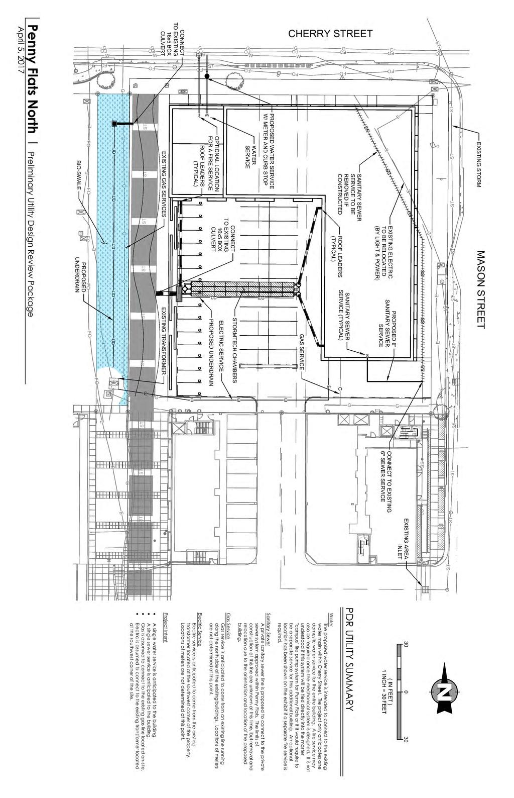
5 supports urban living and business growth where possible. The corner would create a small plaza like condition for people to gather. Where feasible, corners will be created as bulb outs to offer more space for pedestrians. On street parking is proposed on Cherry St., continued on Mason St. as per existing conditions. On Street parking on Mason St. would offer a continuation of the downtown condition as evident immediately south on the block at the City Development Services building. On street parking would help activate the street and provide much needed parking for potential tenants on the ground floor. The internal site would offer planted medians, potential bio swales or rain gardens in the areas closest to the pedestrian linkage. 2 (e). How is your proposal compatible with the surrounding area? The northwest corner of the site is bordered by the Trolley Barn. Care will be given in the design of the building façade so it respects the historic character of the Trolley Barn. We would like to potentially incorporate a trolley car or other historical details/art relating to the Trolley Barn along the pedestrian spine. The East side of the property is next to railway lines from north south line from Mason Street. The northern area opposite the property is dominated by railway easements forcing the Fort Collins Museum of Discovery to be situated away from Cherry Street approximately 250 feet. The scale of this building and distance from Cherry Street is not impacted by the proposed development and the heights are compatible with the size of the Museum building. The block is located north of Block 32 which accommodates the City s municipal building. This block is the northern extent of the civic core that includes three north south blocks that extend to Oak Street where the County Courthouse building is located. The heights of the proposed development are compatible with the Civic Core buildings. The heights proposed for the block are consistent with the heights of the apartments located on the south side of the property. The use of residential apartments also is compatible with the use of this block and south of Cherry St called Mason Street North, which is also a mixed use residential development. The uses for the block propose to be a mixed use condition of residential, commercial and retail. The uses are compatible with the surrounding area and downtown. The development offers an opportunity to create strong connections from the River and the Poudre Trail System to Fort Collins downtown by extending the livable downtown condition north. 2 (f). Is water detention provided? If so, where? (show on site plan) Detention is not required for this site of for the overall design of Penny Flats. 2 (g). How does the site drain now (on and off site)? Will it change? If so, what will change? The site drains to the north into Cherry Street where it enters the existing storm system via multiple inlets. There is an existing area inlet located in the middle of the lot that drains a portion of the existing drive aisle to the north within the precious phases of Penny Flats. The area inlet drains undetained into the existing storm sewer. 2 (h). What is being proposed to treat run off? Underground StormTech chambers are conceptually designed to treat all of the proposed building and the proposed parking area. A Bio swale running along the western property line is proposed to treat all of the stormwater generated from the pedestrian spine.
6 2 (i). How does the proposal impact natural features? The site lacks any natural features due to previous land uses, therefore the proposal does not impact natural features. 2 (j). Do any existing structures have automatic fire sprinklers? Will the new structures have fire sprinklers? There are no existing structures on site. The proposed building will be equipped with a NFPA Type 13 Fire Sprinkler system. 2 (k). Are there any unusual factors and/or characteristics present that may restrict or affect your proposal? We are proposing to vacate the existing Emergency Access Easement. 2 (l). Have you previously submitted an application? Two previous applications were submitted on this project. One in March of 2013 and one in November of (a). Project site boundary and adjacent property uses The surrounding properties are within various zoning districts that include: Downtown District (D), Neighborhood Conservation, Buffer District (NCB), Low Density Mixed use Neighborhood District (LMN), Public Open Lands (POL) and Community Commercial Poudre River District (CCR). Currently there is a multi family residential development located immediately south of this site and one across the street on the east side of Mason Street. The Downtown Transit Center is located on the south side of Maple Street as is the City of Fort Collins government offices. A variety of mixed commercial and retail establishments are located on the east side of College Avenue. Northeast of the property is the Fort Collins Museum of Discovery. 3 (b). Proposed circulation system, and how it ties into existing infrastructure (pedestrian and auto) See the attached site plan. 3 (c). Existing and proposed landscaping (Will trees be removed?) There are no trees on the site. The landscape proposed for the block would comprise of two conditions: Streetscape The streetscape condition would comprise of street trees planted at regular intervals and plantings at the corners and other suitable locations. Planting beds would use native species that demand lower water use. The plantings would also need to be low, so not to restrict sight triangles but also create a safe environment for pedestrians with clear view lines. Interior to Block: The Landscape design within the block will be focused on the easement located on the west side of the site. It will include foundation planting where possible, small plazas and adjoin usable space. The parking area will be screened and separated for the pedestrian easement/linkage with vegetation that potentially could also comprise of rain garden and bioswale plantings for water quality. The linkage may also provide educational information regarding the Fort Collins Trolley System. 3 (d). Existing & proposed buildings (Will they remain? If they will change, how?) There are no existing structures on the property. See attached. The proposed building will consist of Multi family residential in multiple floors. A potential ground level retail/live work will be located along Mason St. Surface and tuck under parking will be provided for the residential units
7 3 (e). Existing natural features (Will these be impacted by the proposal?) There are no existing natural features. 3 (f). On & off site improvements See attached. 3 (g). Location of detention, drainage and water quality features See attached. 3 (h). Emergency vehicle access & fire hydrant location There are currently no existing fire hydrant on the site. Hydrants are proposed at the northwest and southeast corner of the site. Due to the limited access for fire protection, Fire truck staging areas will be located on the northwest corner (on Cherry Street) and the northeast corner (on Mason St.). See attached.

8 PENNY FLATS NORTH FORT COLLINS, CO PR BRINKMAN PARTNERS SITE YIELD STUDY PENNY FLATS NORTH FORT COLLINS, CO PR BRINKMAN PARTNERS SITE YIELD STUDY
9 CHERRY ST. PLAT INFORMATION UTILITY, DRAINAGE & PEDESTRIAN ACCESS EASEMENT 210'-0" EMERGENCY ACCESS EASEMENT (VACATED) BUILDING SETBACK 20'-0" 25'-0" 30'-0" BUILDING SETBACK TROLLEY DEPOT BLOCK 33 - LOT 2 PENNY FLATS SUBDIVISION 200'-0" N. MASON ST. PROJECT LOCATION CHERRY & MASON 10'-0" VICINITY MAP (N.T.S.) N PEDESTRIAN ACCESS EASEMENT MASON STREET FLATS 0 60' 120' PENNY FLATS NORTH FORT COLLINS, CO PR BRINKMAN PARTNERS SITE YIELD STUDY
 BUILDING HEIGHT 63' (MAX. 85') POTENTIAL FIRE ACCESS AREA NUMBER OF STORIES: 4 OR 5 (MAX.")
10 POTENTIAL FIRE ACCESS AREA UTILITY, DRAINAGE & PEDESTRIAN ACCESS EASEMENT 210'-0" CHERRY ST. EMERGENCY ACCESS EASEMENT (VACATED) BUILDING SETBACK SITE DATA SITE PLAN SITE AREA APPROX: 38,044 SF (0.873 AC) BUILDING HEIGHT 63' (MAX. 85') POTENTIAL FIRE ACCESS AREA NUMBER OF STORIES: 4 OR 5 (MAX. 6) BUILDING DATA 20'-0" 25'-0" 30'-0" GROUND FLOOR LEVELS 2-4 LEVEL 5 TOTAL AREA 5,485 GSF 41,865 GSF 12,045 GSF 59,215 GSF BUILDING SETBACK OVERALL UNIT MIX STUDIO (456 SF) 12 UNITS 1 BEDROOMS (600 SF) 35 UNITS 2 BEDROOMS (864 SF) 24 UNITS NUMBER OF UNITS NUMBER OF BEDS 71 UNITS 95 BEDS BLOCK 33 - LOT 2 PENNY FLATS SUBDIVISION 200'-0" N. MASON ST. PROJECT LOCATION CHERRY & MASON 150' PROTECTION DISTANCE POTENTIAL FIRE ACCESS AREA 10'-0" VICINITY MAP (N.T.S.) N PEDESTRIAN ACCESS EASEMENT 0 30' 60' PENNY FLATS NORTH FORT COLLINS, CO PR BRINKMAN PARTNERS SITE YIELD STUDY

11 GROUND FLOOR PLAN 20'-0" 25'-0" CHERRY ST. 210'-0" 20TH STREET BUILDING DATA GROUND FLOOR UNITS (LIVE/WORK) 1 BEDROOMS (600 SF) 3 UNITS 2 BEDROOMS (864 SF) 2 UNITS RESIDENTIAL AMENITY 648 GSF APPROX. AREA 5,485 GSF 50'-0" PARKING DATA AMENITY L/W TOTAL NUMBER PARKING PROVIDED: 59 SPACES CURRENT PARKING RATIOS L/W NUMBER OF UNITS NUMBER OF BEDS 71 UNITS 95 BEDS 59 SPACES/71 UNITS 0.83 SPACES/UNIT 59 SPACES/95 BEDS 0.62 SPACES/BED BLOCK 33 - LOT 2 PENNY FLATS SUBDIVISION L/W L/W 200'-0" N. MASON ST. PROJECT LOCATION CHERRY & MASON L/W TRASH 10'-0" VICINITY MAP (N.T.S.) N GROUND FLOOR PLAN 0 30' 60' PENNY FLATS NORTH FORT COLLINS, CO PR BRINKMAN PARTNERS SITE YIELD STUDY
12 LEVEL 2-4 FLOOR PLAN 20'-0" 25'-0" CHERRY ST. 210'-0" 20TH STREET BUILDING DATA TYPICAL FLOOR UNITS (LEVELS 2-4) STUDIO (456 SF) 3 UNITS 1 BEDROOMS (600 SF) 8 UNITS 2 BEDROOMS (864 SF) 6 UNITS CIRCULATION: APPROX. AREA 2,605 GSF 13,955 GSF S 50'-0" 3 STORIES (ABOVE PODIUM) STUDIO 9 UNITS 1 BEDROOMS 24 UNITS 2 BEDROOMS 18 UNITS S ELEVATOR LOBBY APPROX. AREA 41,865 GSF S BLOCK 33 - LOT 2 PENNY FLATS SUBDIVISION 200'-0" N. MASON ST. PROJECT LOCATION CHERRY & MASON 10'-0" VICINITY MAP (N.T.S.) N TYPICAL FLOOR PLAN (FLOORS 2-4) 0 30' 60' PENNY FLATS NORTH FORT COLLINS, CO PR BRINKMAN PARTNERS SITE YIELD STUDY
13 LEVEL 5 FLOOR PLAN CHERRY ST. 210'-0" 20TH STREET BUILDING DATA LEVEL 5 UNITS (ABOVE PODIUM) STUDIO (456 SF) 3 UNIT 1 BEDROOMS (600 SF) 8 UNITS 2 BEDROOMS (864 SF) 4 UNITS CIRCULATION: 2,425 GSF APPROX. AREA 12,045 GSF S 50'-0" ROOFTOP PATIO 750 GSF S ELEVATOR LOBBY S BLOCK 33 - LOT 2 PENNY FLATS SUBDIVISION 200'-0" N. MASON ST. PROJECT LOCATION CHERRY & MASON 10'-0" VICINITY MAP (N.T.S.) N LEVEL 5 FLOOR PLAN 0 30' 60' PENNY FLATS NORTH FORT COLLINS, CO PR BRINKMAN PARTNERS SITE YIELD STUDY
 BUILDING HEIGHT 63' (MAX.")
 CHERRY ST. N.")

14 SITE AERIAL SITE DATA SITE AREA APPROX: 38,044 SF (0.873 AC) BUILDING HEIGHT 63' (MAX. 85') NUMBER OF STORIES: 4 OR 5 (MAX. 6) CHERRY ST. N. MASON ST BLOCK 33 - LOT 2 PENNY FLATS SUBDIVISION PROJECT LOCATION CHERRY & MASON VICINITY MAP (N.T.S.) PENNY FLATS NORTH FORT COLLINS, CO PR BRINKMAN PARTNERS SITE YIELD STUDY

 CONCEPT MASSING VIEW FROM CHERRY ST.")

15 PERSPECTIVE VIEWS CONCEPT MASSING VIEW FROM N. MASON ST. (LOOKING NORTHWEST) PROJECT LOCATION CHERRY & MASON VICINITY MAP (N.T.S.) CONCEPT MASSING VIEW FROM CHERRY ST. (LOOKING SOUTHEAST) PENNY FLATS NORTH FORT COLLINS, CO PR BRINKMAN PARTNERS SITE YIELD STUDY
16
17
W Harmony Rd. Group Home
 Taft Hill Olt Ct Lemay Timberline Olt Ct 1109 W Harmony Rd Group Home 287 Vicinity Map «1 Douglas Aerial Site Map Wakerobin Ln 25 Mountain Vista Vine 287 Mulberry Prospect Shields Drake Horsetooth 25 ^_
1215 Shields Street Development PDR
 1215 Shields Street Development PDR Vicinity Map 287 Aerial Site Map Douglas 1 «V U 25 14 Mountain Vista Vine Mulberry Drake Lemay Shields Taft Hill Prospect Horsetooth Timberline _ ^ 287 University Ave
Conceptual Review Agenda
 Conceptual Review Agenda Schedule for 12/05/18 281 Conference Room A Wednesday, December 5, 2018 Time Project Name Applicant Info Project Description 8:30 Vine and Shields Multi-Family PDR180015 Todd Parker
Drake Rd & College Ave Spradley Barr Redevelopmentl
 Taft Hill Lemay Timberline Frontage Rd Frontage Rd Drake Rd & College Ave Spradley Barr Redevelopmentl 287 Vicinity Map «1 Douglas Colorado 287 State University 25 Mountain Vista Vine Mulberry Bay Rd Aerial
Staybridge Suites. Aerial Site Map CCR POL. 1 inch = 17,493 feet. 1 inch = 250 feet. Vicinity Map. Zoning Map RL.
 Staybridge Suites Aerial Site Map 1 «2nd St 1st St 14 Vine Mulberry _ ^ U V Drake Lemay Prospect Shields Mountain Vista Buckingham Park Taft Hill Douglas Horsetooth Timberline 3rd St Vicinity Map E Lincoln
Harmony Commons, Lot 1 Office
 Technology Pkwy Taft Hill Lemay Timberline Technology Pkwy Lady Moon Dr Harmony Commons, Lot Office Vicinity Map 87 UV 4 «Douglas Mountain Vista Aerial Site Map Vine 87 Mulberry Prospect Shields Drake
^_ ^_. Sanctuary West UV 14 «1. Aerial Site Map. 1 inch = 16,667 feet. 1 inch RL= 1,042 feet. Vicinity Map. Zoning Map.
 Sitzman Way Briarwood Rd Briarwood Rd Taft Hill Lemay Timberline S Impala Dr Sanctuary West W Hartman St UE W Magnolia St Arlene Dr 287 Vicinity Map ^_ ^_ ^_ Cherry St Shields Zoning Map Sunrise Ln UV
Preliminary Design Review. Poudre Garage Mixed Use December 14, 2015
 Preliminary Design Review December 14, 2015 1 Development Review Guide STEP 2 of 8 PRELIMINARY DESIGN REVIEW: APPLICATION General Information Preliminary design review is an opportunity for an applicant
*BOLDED ITEMS ARE REQUIRED* *The more info provided, the more detailed your comments from staff will be.* Project Name
 Development Review Guide STEP 2 of 8 PRELIMINARY DESIGN REVIEW: APPLICATION General Information Preliminary design review is an opportunity for an applicant to discuss the requirements, standards, procedure,
Jason Holland 4/8/2015 x. *BOLDED ITEMS ARE REQUIRED* *The more info provided, the more detailed your comments from staff will be.
 Development Review Guide STEP 2 of 8 PRELIMINARY DESIGN REVIEW: APPLICATION General Information Preliminary design review is an opportunity for an applicant to discuss the requirements, standards, procedure,
Conceptual Review Agenda
 Conceptual Review Agenda Schedule for 10/23/17 to 10/23/17 281 Conference Room A Monday, October 23, 2017 Time Project Name Applicant Info Project Description Planner 9:30 Preston-Kelley Subdivision -
Conceptual Review Agenda
 Conceptual Review Agenda Schedule for 04/09/18 to 04/09/18 281 Conference Room A Monday, April 9, 2018 Time Project Name Applicant Info Project Description Planner 9:30 College & Trilby Multi-Family CDR180019
Conceptual Review Agenda
 Conceptual Review Agenda Schedule for 02/27/17 to 02/27/17 281 Conference Room A Monday, February 27, 2017 Time Project Name Applicant Info Project Description Planner 9:30 419 Wood Street Multi-Family
Harmony Technology Park Third Filing, Second Replat Custom Blending, Project Development Plan/Final Development Plan - FDP #130021
 ITEM NO FDP #130021 MEETING DATE July 23, 2013 STAFF Pete Wray ADMINISTRATIVE TYPE I HEARING STAFF REPORT PROJECT: APPLICANT: OWNER: Harmony Technology Park Third Filing, Second Replat Custom Blending,
PDR /21/15 Noah Beals 1/7/15 xx
 PDR150001 1/21/15 Noah Beals 1/7/15 xx 01.07.15 HTP Harmony Frontage Infrastructure Preliminary Design Review Project Narrative a) What are you proposing/use? The HTP Harmony Frontage Infrastructure project
Developer s Program. The Station at East 54
 Developer s Program The Station at East 54 Existing Conditions The Station at East 54 is proposed for a 1.12 acre site at the northeast corner of Hamilton Road and Prestwick Road, tucked between the East
EXHIBIT B PROJECT NARRATIVE POULSBO MEADOWS
 EXHIBIT B PROJECT NARRATIVE POULSBO MEADOWS Name of Project: Poulsbo Meadows; A Planned Residential Development (PRD)/Plat Applicants Name: PBH Group LLC/Byron Harris PO Box 1010 Silverdale, WA 98038 Description
Conceptual Review Agenda
 Conceptual Review Agenda Schedule for 06/02/14 to 06/02/14 281 Conference Room A Monday, June 2, 2014 Time Project Name Applicant Info Project Description Planner 9:30 1005 Riverside Avenue - Office CDR140036
Project phasing plan (if applicable) 12 copies of site plan
 12 copies of site plan") SITE PLAN REVIEW PERMIT APPLICATION City of Grand Haven, 11 N. Sixth Street, Grand Haven, MI 49417 Phone: (616) 847-3490 Fax: (616) 844-2051 Website: www.grandhaven.org 1. Project Information Address/location
SITE PLAN REVIEW PERMIT APPLICATION City of Grand Haven, 11 N. Sixth Street, Grand Haven, MI 49417 Phone: (616) 847-3490 Fax: (616) 844-2051 Website: www.grandhaven.org 1. Project Information Address/location
URBAN DESIGN BRIEF URBAN DESIGN BRIEF 721 FRANKLIN BLVD, CAMBRIDGE August 2018
 URBAN DESIGN BRIEF URBAN DESIGN BRIEF 721 FRANKLIN BLVD, CAMBRIDGE August 2018 DESIGN BRIEF CONTENTS PART A 1.0 INTRODUCTION 2.0 DESCRIPTION & ANALYSIS OF SITE CONTEXT 3.0 DESIGN CONSTRAINTS AND OPPORTUNITIES
MEMORANDUM. I2 District Downtown Parking Overlay District 24,000 square feet /.55 acres. Industrial Employment District North Loop Small Area Plan
 Department of Community Planning & Economic Development 50 South 4th Street, Room 300 Minneapolis, MN 5545-385 MEMORANDUM To: City Planning Commission, Committee of the Whole Prepared By: Peter Crandall,
ARTICLE 6: Special and Planned Development Districts
 ARTICLE 6: Special and Planned Development Districts 6-10 Traditional Neighborhood Development (TND) District 6-10.10 Purpose and Intent The Traditional Neighborhood Development (TND) District provides
Applicant Name Phone / Fax / Address City State Zip Code . Property Owner Phone / Fax / Address City State Zip Code
 Master Development Plan Application Community Development Department City of Redmond 411 SW 9 th Street Redmond, Oregon 97756 541-923-7721 541-548-0706 FAX Master Development Plan Fee $38,862.52 File Number
Urban Design Brief December 23, 2015 Southside Construction Group Official Plan & Zoning By-Law Amendment
 Urban Design Brief Proposed Official Plan & Zoning By-Law Amendment 3244, 3263 and 3274 Wonderland Road South Southside Group December 23, 2015 TABLE OF CONTENTS Page No. INTRODUCTION... 1 SECTION 1 LAND
SPECIFIC PLAN Requirements
 CITY OF LANCASTER PLANNING DEPARTMENT 44933 Fern Avenue, Lancaster, California 93534 (661) 723-6100 SPECIFIC PLAN Requirements Purpose The purpose of a specific plan is to provide for the logical development
The open space system should provide connective elements, relate to natural resources, and enhance the suburban character of the landscape..
 The open space system should provide connective elements, relate to natural resources, and enhance the suburban character of the landscape.. Mixed-use and infill development should maintain or enhance
Site Development Plan (SDP) Checklist
 Checklist") Development Services Department 100 N. Wilcox Street, Castle Rock CO 80104 303-660-1393 or CRGov.com Site Development Plan (SDP) Checklist A complete Site Development Plan (SDP) submittal will contain
Development Services Department 100 N. Wilcox Street, Castle Rock CO 80104 303-660-1393 or CRGov.com Site Development Plan (SDP) Checklist A complete Site Development Plan (SDP) submittal will contain
Gold Line Bus Rapid Transit Transit Oriented Development (BRTOD) Helmo Station Area Plan
 Helmo Station Area Plan") Appendix F Gold Line Bus Rapid Transit Transit Oriented Development (BRTOD) Helmo Station Area Plan Introduction and Purpose of the Plan The Gold Line Bus Rapid Transit facility is an eleven-mile dedicated
Appendix F Gold Line Bus Rapid Transit Transit Oriented Development (BRTOD) Helmo Station Area Plan Introduction and Purpose of the Plan The Gold Line Bus Rapid Transit facility is an eleven-mile dedicated
KEIZER STATION PLAN INTRODUCTION
 KEIZER STATION PLAN INTRODUCTION Planning for this area began in 1987 when the Keizer Comprehensive Plan established the Chemawa Activity Center and McNary Activity Center. The first Chemawa Activity Center
The following concept plans and illustrations are the result of this 10 month study of the alley connections from CSU to the River District.
 W E L C O M E T O T H E F O R T C O L L I N S D O W N T O W N A L L E Y S A N D I N T E G R AT E D W A L K W AY S M A S T E R P L A N O P E N H O U S E The following concept plans and illustrations are
M E M O R A N D U M SITE DATA
 Department of Community Planning & Economic Development 250 South 4 th Street, Room 300 Minneapolis, MN 55415-1385 M E M O R A N D U M TO: City Planning Commission, Committee of the Whole FROM: Lisa Steiner,
EXISTING COMPREHENSIVE PLAN
 EXISTING COMPREHENSIVE PLAN Town Center Land Use Element: V. LAND USE POLICIES Town Center Mercer Island's business district vision as described in "Your Mercer Island Citizen-Designed Downtown" was an
REQUEST Current Zoning: O-15(CD) (office) Proposed Zoning: TOD-M(CD) (transit oriented development mixed-use, conditional)
 (office) Proposed Zoning: TOD-M(CD) (transit oriented development mixed-use, conditional)") Rezoning Petition 2016-117 Zoning Committee Recommendation January 4, 2017 REQUEST Current Zoning: O-15(CD) (office) Proposed Zoning: TOD-M(CD) (transit oriented development mixed-use, conditional) LOCATION
Rezoning Petition 2016-117 Zoning Committee Recommendation January 4, 2017 REQUEST Current Zoning: O-15(CD) (office) Proposed Zoning: TOD-M(CD) (transit oriented development mixed-use, conditional) LOCATION
Design Review Application *Please call prior to submittal meeting to determine applicable fees*
 CITY OF EAGLE 660 E. Civic Lane, Eagle, ID 83616 Phone#: (208) 939-0227 Fax: (208) 938-3854 Design Review Application *Please call prior to submittal meeting to determine applicable fees* FILE NO.: CROSS
CITY OF FORT COLLINS TYPE 1 ADMINISTRATIVE HEARING FINDINGS AND DECISION. Elevations Credit Union (2025 S. College Avenue)
") CITY OF FORT COLLINS TYPE 1 ADMINISTRATIVE HEARING FINDINGS AND DECISION HEARING DATE: September 28, 2016 PROJECT NAME: Elevations Credit Union (2025 S. College Avenue) CASE NUMBER: PDP #160021 APPLICANT:
CITY OF FORT COLLINS TYPE 1 ADMINISTRATIVE HEARING FINDINGS AND DECISION HEARING DATE: September 28, 2016 PROJECT NAME: Elevations Credit Union (2025 S. College Avenue) CASE NUMBER: PDP #160021 APPLICANT:
DENVER DESIGN DISTRICT GDP
 DENVER DESIGN DISTRICT GDP Urban Design Standards and Guidelines November 17, 2008 Amended February 3, 2016 City and County of Denver CF Property Management, Inc. C/O Denver Design District - Starboard
Conceptual Review Agenda
 Conceptual Review Agenda June 23, 2008 9:30 10:00 10:30 Project: Replat of Lots 13&16 Loomis Subdivision (Blk 267) Location: 429 Whitcomb (NW corner Whitcomb & Mulberry) Applicant: Craig Hughes Contact
North Downtown Specific Plan MEMORANDUM
 North Downtown Specific Plan MEMORANDUM MEETING DATE: November 13, 2017 TO: Members of the North Downtown Specific Plan Advisory Committee FROM: Jeanine Cavalli, Senior Planner SUBJECT: Materials for the
MONTGOMERY COUNTY PLANNING DEPARTMENT THE MARYLAND-NATIONAL CAPITAL PARK AND PLANNING COMMISSION
 MONTGOMERY COUNTY PLANNING DEPARTMENT THE MARYLAND-NATIONAL CAPITAL PARK AND PLANNING COMMISSION MCPB Item No. Date: 3.10.2016 Site Plan 820160040 Nora School Parker Smith, Planning Technician, Area 1,
F. The following uses in the HR District: attached single-family dwellings, condominiums, and institutional uses; and
 1102 DESIGN REVIEW 1102.01 PURPOSE AND APPLICABILITY Section 1102 is adopted to provide standards, criteria, and procedures under which design review may be approved. Design review is required for: A.
ELMVALE ACRES SHOPPING CENTRE MASTER PLAN
 ELMVALE ACRES SHOPPING CENTRE MASTER PLAN Contents 1.0 INTRODUCTION... 2 2.0 LOCATION... 2 3.0 EXISTING CONTEXT... 2 4.0 VISION & GUIDING PRINCIPLES... 2 5.0 LAND USE AND BUILT FORM... 4 5.1 St. Laurent
WEST LOOP DESIGN GUIDELINES CHECKLIST
 WEST LOOP DESIGN GUIDELINES CHECKLIST Section 1.0 General Strategies 1.1 DESIGN EXCELLENCE: ENCOURAGE HIGH QUALITY AND INNOVATIVE DESIGN OF NEW BUILDINGS WITHIN THE WEST LOOP WITHOUT BEING PRESCRIPTIVE
MONTGOMERY COUNTY PLANNING DEPARTMENT THE MARYLAND-NATIONAL CAPITAL PARK AND PLANNING COMMISSION
 MONTGOMERY COUNTY PLANNING DEPARTMENT THE MARYLAND-NATIONAL CAPITAL PARK AND PLANNING COMMISSION MCPB Item No. Date: 1/26/12 Hanover Shady Grove, Sketch Plan 320120020 Joshua Sloan, Coordinator, Joshua.Sloan@MontgomeryPlanning.org,
523, 525 and 525A Adelaide Street West - Zoning Amendment Application - Preliminary Report
 STAFF REPORT ACTION REQUIRED 523, 525 and 525A Adelaide Street West - Zoning Amendment Application - Preliminary Report Date: May 12, 2012 To: From: Wards: Reference Number: Toronto and East York Community
(DC1) Direct Development Control Provision DC1 Area 4
 Direct Development Control Provision DC1 Area 4") . General Purpose (DC) Direct Development Control Provision DC Area 4 The purpose of this Provision is to provide for an area of commercial office employment and residential development in support of the
. General Purpose (DC) Direct Development Control Provision DC Area 4 The purpose of this Provision is to provide for an area of commercial office employment and residential development in support of the
CITY OF FORT COLLINS TYPE 1 ADMINISTRATIVE HEARING FINDINGS AND DECISION. CS Commercial, LLC 1337 Riverside Avenue, Unit 1 Fort Collins, CO 80524
 CITY OF FORT COLLINS TYPE 1 ADMINISTRATIVE HEARING FINDINGS AND DECISION HEARING DATE: January 7, 2016 PROJECT NAME: Caring Smiles Dental Clinic CASE NUMBER: FDP #150010 APPLICANT: OWNER: HEARING OFFICER:
PINE CURVE REZONING. Property does not meet criteria for open space preservation and is not a candidate for a park
 PINE CURVE REZONING BACKGROUND Purchased as two parcels in 2001 and 2002 Annexed and Zoned Greater Downtown District Historic Center September 25, 2002 and October 7, 2002 WHAT THE PROJECT IS AND IS NOT
PROPOSED WATERFRONT DISTRICT DESIGN STANDARDS
 PROPOSED WATERFRONT DISTRICT DESIGN STANDARDS 20.25 DESIGN REVIEW. 20.25.080 WATERFRONT DISTRICT A. Purpose. This section is intended to implement The Waterfront District Subarea Plan by: 1. Creating a
Ten Mile Creek Planning Area
 PLANNING AREA POLICIES TEN MILE CREEK Ten Mile Creek Planning Area Location and Context The Ten Mile Creek Planning Area ( Ten Mile Creek area ) is located south of the current Boise AOCI, generally south
Net Land Area (NLA): Area within zoning lot boundaries NLA= sq. ft. a) Credited Street Area (total adjacent frontage) x ½ width of public rightof-way
: Area within zoning lot boundaries NLA= sq. ft. a) Credited Street Area (total adjacent frontage) x ½ width of public rightof-way") PROJECT FACT SHEET Section A: Project Information Application type: Date: Project Name: Use Type: (check/list all that apply) Office/Institutional Residential Mixed-Use Other: Overlay District: (check
PROJECT FACT SHEET Section A: Project Information Application type: Date: Project Name: Use Type: (check/list all that apply) Office/Institutional Residential Mixed-Use Other: Overlay District: (check
VEHICULAR AND PEDESTRIAN CIRCULATION
 This perspective sketch communicates the intended character and quality of a proposed streetscape design. Locate benches near a major intersection where people tend to gather. Seating and lighting provide
14 October 10, 2012 Public Hearing APPLICANT: MPB, INC
 14 October 10, 2012 Public Hearing APPLICANT: MPB, INC PROPERTY OWNER: MUNDEN & ASSOCIATES, LP STAFF PLANNER: Karen Prochilo REQUEST: Conditional Change of Zoning (AG-1 & AG-2 to Conditional O-2) ADDRESS
WATERFRONT DISTRICT DESIGN STANDARDS
 WATERFRONT DISTRICT DESIGN STANDARDS 20.25.080 WATERFRONT DISTRICT A. Purpose. This section is intended to implement The Waterfront District Subarea Plan by: 1. Creating a safe, vibrant mixed-use urban
URBAN DESIGN BRIEF NORTHVIEW FUNERAL HOME HIGHBURY AVE N, LONDON, ON
 URBAN DESIGN BRIEF NORTHVIEW FUNERAL HOME - 1490 HIGHBURY AVE N, LONDON, ON 1.1Purpose The intent of the following report is to identify an opportunity for redevelopment of two residential properties within
Town of Portola Valley General Plan. Nathhorst Triangle Area Plan
 Town of Portola Valley General Plan Amended December 10, 1997 Table of Contents Introduction... 1 Planning Area... 1 Objectives... 2 Principles... 2 Standards... 4 Description... 4 Community Commercial...
Planning Districts INTRODUCTION
 INTRODUCTION To facilitate detailed examination of development prospects for all areas of the community, Delano has been divided into 14 planning districts. The location of these planning districts is
CITY COUNCIL STUDY SESSION MEMORANDUM
 City and County of Broomfield, Colorado CITY COUNCIL STUDY SESSION MEMORANDUM To: From: Prepared by: Mayor and City Council Charles Ozaki, City and County Manager Kevin Standbridge, Deputy City and County
ARTICLE 17 SITE PLAN REVIEW
 ARTICLE 17 SITE PLAN REVIEW 17.01 INTENT AND PURPOSE The intent of this section is to provide for consultation and cooperation between the applicant and the township planning commission so that the applicant
VISION AND GUIDING DESIGN PRINCIPLES
 pleasure point commercial corridor VISION AND GUIDING DESIGN PRINCIPLES Public Draft November 26, 2018 County of Santa Cruz with assistance from MIG CONTENTS PART I: INTRODUCTION AND VISION... 3 Community
SUBJECT: PREDEVELOPMENT PLAN REVIEW OF PROJECT LOCATED AT E. COLORADO BOULEVARD (PASEO COLORADO)
") TO: FROM: Honorable Mayor and City Council Planning & Community Development Department SUBJECT: PREDEVELOPMENT PLAN REVIEW OF PROJECT LOCATED AT 260-400 E. COLORADO BOULEVARD (PASEO COLORADO) RECOMMENDATION:
TO: FROM: Honorable Mayor and City Council Planning & Community Development Department SUBJECT: PREDEVELOPMENT PLAN REVIEW OF PROJECT LOCATED AT 260-400 E. COLORADO BOULEVARD (PASEO COLORADO) RECOMMENDATION:
section five BEAUTIFICATION PLAN
 section five BEAUTIFICATION PLAN BEAUTIFICATION PLAN Section Five Beautification Plan The goal of the Beautification Plan is to improve the Route 8-Sunnyland Corridor in terms of aesthetics and to create
Chapter 3: Office & Office Mixed-Use Project Types
 Chapter Contents Purpose... 3-2 Applicability and Use Types...3-3 (1) Site Design...3-4 Building Placement and Orientation...3-5 Circulation and Vehicle Parking...3-6 Bicycle/Pedestrian Amenities...3-8
PINE CURVE REZONING. BACKGROUND Purchased as two parcels in 2001 and 2002
 BACKGROUND Purchased as two parcels in 2001 and 2002 WHAT THE PROJECT IS AND IS NOT A Rezoning establishes the land use standards for Annexed and Zoned Greater Downtown District Historic Center September
9 th Street Sub Area Plan
 9 th Street Sub Area Plan In the 1990 s, when the Township prepared the last Master Plan, the 9 th Street corridor was studied as part of a larger 9 th Street Focus Area that included the West Main Street
Transportation. Strategies for Action
 Transportation A major priority for the Overlake Neighborhood is to develop a multimodal transportation system. To achieve this system, a balance has to be found among travel, circulation and access needs;
Illustration of Eastlake Farmer s Cooperative Grain Elevator. Chapter 5: implementation 5-1
 Illustration of Eastlake Farmer s Cooperative Grain Elevator Chapter 5: implementation 5-1 chapter 5: implementation Introduction The Eastlake Subarea Plan includes a wide range of recommendations intended
CITY PLANNING COMMISSION AGENDA. ITEM NO: 6.a 6.b STAFF: LONNA THELEN
 Page 156 CITY PLANNING COMMISSION AGENDA ITEM NO: 6.a 6.b STAFF: LONNA THELEN FILE NO(S): A. - CPC ZC 08-00069 QUASI-JUDICIAL B. - CPC CU 08-00070 QUASI-JUDICIAL PROJECT: APPLICANT: OWNER: PHIL LONG VALUCAR
Policies and Code Intent Sections Related to Town Center
 Policies and Code Intent Sections Related to Town Center The Town Center Vision is scattered throughout the Comprehensive Plan, development code and the 1994 Town Center Plan. What follows are sections
URBAN DESIGN BRIEF 181 Burloak Drive, Oakville
 URBAN DESIGN BRIEF 181 Burloak Drive, Oakville February 2017 Our File: 1730B 230-7050 WESTON ROAD / WOODBRIDGE / ONTARIO / L4L 8G7 / T: 905 761 5588/ F: 905 761 5589/WWW.MHBCPLAN.COM TABLE OF CONTENTS
CITY OF THORNTON, COUNTY OF ADAMS, STATE OF COLORADO EAST 124TH AVE WASHINGTON CENTER PKWY WASHINGTON ST PROJECT LOCATION PRIVATE DRIVE
 EXISTING OWNER WASHINGTON CENTER, LLC 7400 CRESTLINE CIRCLE SUITE 150 GREENWOOD VILLAGE, CO 80111 720-554-9419 STANDARD SYMBOLS RCP STORM SEWER PVC STORM SEWER PVC ROOF DRAIN/FOUNDATION DRAIN SANITARY
Old Town Neighborhoods Plan. Choices Event Wednesday, December 9, 2015
 Old Town Neighborhoods Plan Choices Event Wednesday, December 9, 2015 Agenda 6:00 6:10 p.m. Welcome + Sign In 6:10 6:30 p.m. Presentation 6:30 8:00 p.m. Workshop + Open House Seeking your input on: Neighborhood
Parcel 5. Level 1 Application March 12, Design Submittal POST ROAD RESIDENTIAL
 P:\3371 Providence \graphic\meetings and Presentations\2018.03.12_Level 1 Submission/ I-195 Level Redevelopment 1 Design Submission.pdf District Commission Introduction The Level 1 conceptualization of
NEIGHBORHOOD 3: UNIVERSITY EDGE
 NEIGHBORHOOD 3: UNIVERSITY EDGE Aerial View of North Indiana Avenue EXISTING CHARACTER The University Edge neighborhood represents the primary town/gown interface between the campus and the city of Bloomington,
Danvers High Street I-1 District Study
 Danvers High Street I-1 District Study Presentation of Final Recommendations Planning Board Presentation June 26 th, 2018 1 Introductions Metropolitan Area Planning Council Sam Cleaves AICP, Principal
The Village. Chapter 3. Mixed Use Development Plan SPECIFIC PLAN
 The Village SPECIFIC PLAN Chapter 3 3.1 INTRODUCTION 3.1.1 Purpose This Chapter describes the development regulations applicable to the Mixed-Use and Transit Center Planning Areas. These form-based regulations
CHAPTER FIVE COMMUNITY DESIGN
 CHAPTER FIVE COMMUNITY DESIGN CHAPTER FIVE - COMMUNITY DESIGN Assumptions Frazier Park and Lebec have historically developed according to different patterns of spatial form. While both communities are
URBAN DESIGN BRIEF Gordon Street City of Guelph. Prepared on behalf of Ontario Inc. March 25, Project No. 1507
 URBAN DESIGN BRIEF 1131 Gordon Street City of Guelph Prepared on behalf of 1876698 Ontario Inc. March 25, 2016 Project No. 1507 423 Woolwich Street, Suite 201, Guelph, Ontario, N1H 3X3 Phone (519) 836-7526
APPLICATION FOR REZONING PROPERTY CITY OF HOLLAND, MICHIGAN. Name of Applicant. Address, and Phone # of Applicant
 APPLICATION FOR REZONING PROPERTY CITY OF HOLLAND, MICHIGAN Name of Applicant Address, Email and Phone # of Applicant Name and Address of Owner (if other than applicant) Ownership Interest of Applicant
ZONING ORDINANCE FOR THE ZONED UNINCORPORATED AREAS ARTICLE 1150 OF PUTNAM COUNTY, WEST VIRGINIA Page 95 ARTICLE 1150 SITE PLAN REVIEW
 OF PUTNAM COUNTY, WEST VIRGINIA Page 95 1150.01 PURPOSE 1150.02 APPLICABILITY 1150.03 APPLICATION PROCESS 1150.04 REVIEW PROCESS 1150.05 REVIEW CRITERIA 1150.06 SITE PLAN GUIDELINES 1150.01 PURPOSE ARTICLE
HEALTH SCIENCES BUILDING REDEVELOPMENT PROJECT
 INTRODUCTION In recent years, the University of Cincinnati (University) has demonstrated a commitment to identifying and implementing sustainable goals and objectives throughout University s Uptown Campuses.
Baumgarten MPUD. Exhibit 3 Evaluation Criteria
 Pursuant to LDC subsections 10.02.13 B, 10.02.08 F and Chapter 3 G. of the Administrative Code, staff s analysis and recommendation to the Planning Commission, and the Planning Commission s recommendation
30 and 44 Zorra Street - Zoning By-law Amendment Application - Preliminary Report
 STAFF REPORT ACTION REQUIRED 30 and 44 Zorra Street - Zoning By-law Amendment Application - Preliminary Report Date: March 14, 2016 To: From: Wards: Reference Number: Etobicoke York Community Council Director,
Staff Report to the North Ogden City Planning Commission
 Staff Report to the North Ogden City Planning Commission SYNOPSIS / APPLICATION INFORMATION Application Request: Concept review on a legislative application to rezone land located at approximately 1750
MONTGOMERY COUNTY PLANNING DEPARTMENT THE MARYLAND-NATIONAL CAPITAL PARK AND PLANNING COMMISSION
 MONTGOMERY COUNTY PLANNING DEPARTMENT THE MARYLAND-NATIONAL CAPITAL PARK AND PLANNING COMMISSION MCPB Item No. Date: 12-10-15 Leisure World Clubhouse II Addition Fitness Center, Limited Site Plan Amendment
Planning Board Briefing
 Planning Board Briefing Why Now? The Sector Plan Implementation Chapter States: Before Stage 1 begins, the following must occur: Approval of the Sectional Map Amendment. Approval of the Greater Lyttonsville
1071 King Street West Zoning Amendment Application - Preliminary Report
 STAFF REPORT ACTION REQUIRED 1071 King Street West Zoning Amendment Application - Preliminary Report Date: August 9, 2012 To: From: Wards: Reference Number: Toronto and East York Community Council Director,
GENERAL INFORMATIONaaaaaaaaaaaaaaaaaaaaaaaaaaaaaaaa
 To: Planning and Zoning Commission From: City Staff Date: November 15, 2016 Re: Case #16026 Raymore Activity Center Site Plan GENERAL INFORMATIONaaaaaaaaaaaaaaaaaaaaaaaaaaaaaaaa Applicant/ Property Owner:
DRAFT Northeast Quadrant of Kipling Avenue and Highway 7 DRAFT AUGUST 29, Goals Land Use. The goals of this Plan are to:
 AUGUST 29, 2017 12.15 Northeast Quadrant of Kipling Avenue and Highway 7 12.15.1 Goals 12.15.2 Land Use The goals of this Plan are to: 12.15.2.1 General Provisions: a) Ensure the development of a compact
Request for Proposals For the purchase and redevelopment of Cityowned property in the Historic Downtown. 109 South Boyd Street
 300 West Plant Street Winter Garden, FL 407-656-4111 RFP # 15-103 Request for Proposals For the purchase and redevelopment of Cityowned property in the Historic Downtown District, generally located at:
Appendix C: Interim Mixed-Use Evaluation Criteria
 Appendix C: Interim Mixed-Use Evaluation Criteria C-1 Appendix C: Interim Mixed-Use Evaluation Criteria PURPOSE: The implementation of numerous policies contained within the Master Plan hinges on the creation
Table of Contents. Elm Avenue Improvement Plan City of Waco, Texas. Introduction 1. Existing Context 1 Figure 1 2.
 Table of Contents Introduction 1 Existing Context 1 Figure 1 2 Plan Guidelines 3 Future Urban Form 4 The West-End 4 Main Street 6 The East-End 7 Figure 2 9 Public Improvement Recommendations 7 General
OCEANSIDE DEVELOPER S CONFERENCE. 1. 9:30-10:30 a.m. Proposed hotel on a 12,000 sq. ft. site at the northeast corner of Topeka St. and Tremont St.
 1 AGENDA OCEANSIDE DEVELOPER S CONFERENCE Wednesday, February 1st, 2017, 9:30 a.m. City Hall South, 1 st Floor, Guajome Room 1. 9:30-10:30 a.m. Proposed hotel on a 12,000 sq. ft. site at the northeast
Conceptual Review Agenda
 Conceptual Review Agenda Schedule for 10/28/13 to 10/28/13 281 Conference Room A Monday, October 28, 2013 Time Project Name Applicant Info Project Description Planner 9:30 Aggie Village North Redevelopment
Colerain Township report to. Hamilton County Regional Planning Commission. December 2, 2010, 1:00PM. t a f f r e p o r t
 Colerain Township report to Hamilton County Regional Planning Commission December 2, 2010, 1:00PM Preliminary Plan: Case No.: ZA2001-04, Forevergreen Prepared By: Amy Bancroft, Land Use Planner t a f f
Metro. Activity Center Design Guidelines. Recommendations For Developing Focused, Mixed-Use Commercial/Residential Centers
 Metro Activity Center Design Guidelines Recommendations For Developing Focused, Mixed-Use Commercial/Residential Centers Metro Activity Centers What is a MAC? Legacy, the adopted guide for the future growth
Conceptual Review Agenda
 Conceptual Review Agenda March 9, 2009 9:30 10:00 10:30 11:00 11:30 Project: Little Gadgets Daycare Center Church expansion to include café and events center Location: 363 Jefferson (Iasis Church) Applicant:
Planning Commission April 4, 2013 BOCC Workshop Page 1
 Planning Commission April 4, 2013 BOCC Workshop Page 1 Planning Commission April 4, 2013 BOCC Workshop Page 2 Planning Commission April 4, 2013 BOCC Workshop Page 3 Planning Commission April 4, 2013 BOCC
PLANNING COMMISSION REPORT
 PLANNING COMMISSION REPORT REZONING CASE NO. RZ-14-002 REPORT DATE: February 10, 2015 CASE NAME: 9990 W. Alameda Ave. Rezoning PLANNING COMMISSION DATE: February 18, 2015 ADDRESS OF REZONING PROPOSAL:
Mitchell Ranch South MPUD Application for Master Planned Unit Development Approval Project Narrative. Introduction
 Mitchell Ranch South MPUD Application for Master Planned Unit Development Approval Project Narrative Introduction Mitchell Ranch South is a proposed single family (detached) residential development on
CONSENT CALENDAR CITY PLANNING COMMISSION AGENDA ITEM NO: A.1, A.2 STAFF: LARRY LARSEN
 Page 8 CONSENT CALENDAR CITY PLANNING COMMISSION AGENDA ITEM NO: A.1, A.2 STAFF: LARRY LARSEN FILE NO: CPC PUZ 14-00013 - QUASI-JUDICIAL FILE NO: CPC PUD 14-00014 QUASI-JUDICIAL PROJECT: APPLICANT: OWNER: