Conceptual Review Agenda
|
|
|
- Terence McCarthy
- 5 years ago
- Views:
Transcription
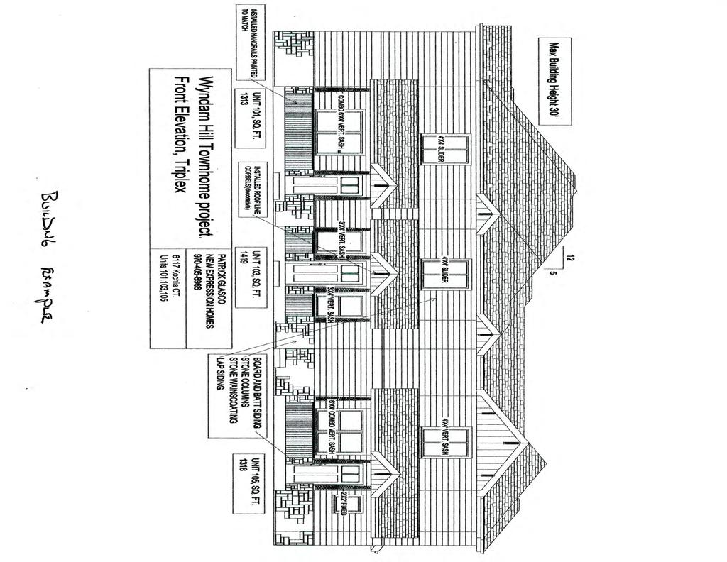
1 Conceptual Review Agenda Schedule for 04/09/18 to 04/09/ Conference Room A Monday, April 9, 2018 Time Project Name Applicant Info Project Description Planner 9:30 College & Trilby Multi-Family CDR Kelly Will (970) firsthometodreamhome@hotmail.com 10:15 Dellenbach Parking Jeffrey Errett CDR (970) je@the-architects-studio.com This is a request to construct townhomes near the southeast corner of S College Ave and E Trilby Rd (parcel# ). The applicant is waiting on soil testing before finalizing a site layout but is proposing 8-9 dwelling units per acre in 2-story, 3 or 4-plex buildings with attached garages. Access to the development will be on the west off of College Ave. Approximately 1/3 of the site would be green space with walking trails. The proposed project is within the Low-Density Mixed-Use (LMN) zone and is subject to Planning and Zoning Board (Type 2) review. This is a request to demolish the building at 3121 W Frontage Rd and convert the lot to vehicle display and inventory parking for the adjacent car dealerships (parcel # ). Site access would not change and additional landscaping would be added to parking lot islands. The proposed project is within the General Commercial (CG) zone district and is subject to Planning and Zoning Board (Type 2) Review. Clay Frickey Jason Holland Agenda as of 03/30/18 at 11:07 am Page 1 of 2
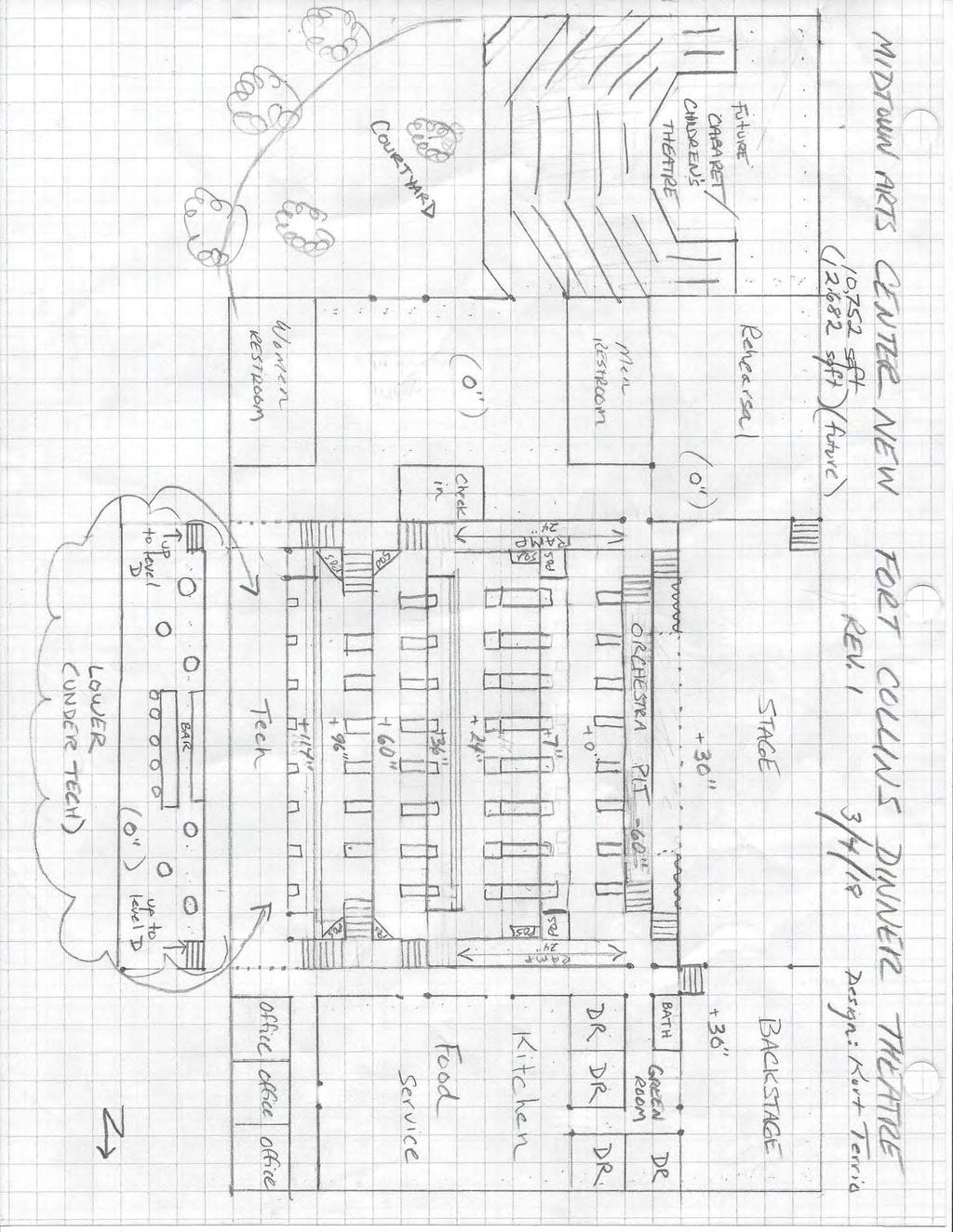
2 Monday, April 9, 2018 Time 11:00 Project Name Applicant Info Project Description Planner Dinner Theatre CDR Eric Larsen (970) This is a request to construct a 10,000-square foot dinner theater facility at 2115 S Timberline Rd (parcel # ). The building would be located on the southeast corner of Joseph Allen Dr and Bear Mountain Dr with parking to the east of the building. Access to the lot would be from the north off Bear Mountain Dr. The proposed project is within the Industrial (I) zone district and is subject to the Addition of Permitted Use (APU) process. Pete Wray Agenda as of 03/30/18 at 11:07 am Page 2 of 2


3 S College Ave Strasburg Dr Taft Hill Kevin Dr Lemay Timberline Debra Dr Kevin Dr College & Trilby Multi-Family Vicinity Map UV 14 «1 Douglas Discovery Montessori Galaxy Ct Galaxy Way S College Ave Aerial Site Map Mountain Vista Vine Mulberry Constellation Dr Orbit Way Prospect Uranus St Shields Drake Horsetooth Solar Ct Lynn Dr Strader Ln Vivian St Vivian Ct Kyle Ave Harmony W Trilby Rd E Trilby Rd Yuma Pl Idalia Ct Little Peoples Landing ^_ Trilby ^_ ^_ Rick Dr Gary Dr Idalia Dr 1 inch = 16,667 feet Pitner Dr Flagler Rd Avondale Rd Sedgwick Dr Zoning Map Hudson Ct CG NC E Trilby Rd CL RL LMN Homestead Park Rick Dr Woodrow Dr Wray Ct Coyote Ridge Elementary MMN Lynn Dr Gary Dr Pitner Dr Strader Ln Egyptian Dr Egyptian Ct Cheops Ct POL Vivian St UE Lyeena Ct Destini Dr LMN Lyfka St Cleopatra St Vivian Ct Stoney San Kyle Ave Brook Rd Juan Dr Triangle Dr E Sparrow Pl Coyote Trail Dr «287 Robert Benson Lake Stoney Brook Rd Bow Creek Ln Bend Dr Shady San Juan Dr Water's Way Park Jansen Dr Triangle Dr Robert Benson Lake POL Water's Way Park 1 inch = 1,250 feet V ictoria Dr 1 inch = 667 feet These map products and all underlying data are developed for use by the City of Fort Collins for its internal purposes only, and were not designed or intended for general use by members of the public. The City makes no representation or warranty as to its accuracy, timeliness, or completeness, and in particular, its accuracy in labeling or displaying dimensions, contours, property boundaries, or placement of location of any map features thereon. THE CITY OF FORT COLLINS MAKES NO WARRANTY OF MERCHANTABILITY OR WARRANTY FOR FITNESS OF USE FOR PARTICULAR PURPOSE, EXPRESSED OR IMPLIED, WITH RESPECT TO THESE MAP PRODUCTS OR THE UNDERLYING DATA. Any users of these map products, map applications, or data, accepts same AS IS, WITH ALL FAULTS, and assumes all responsibility of the use thereof, and further covenants and agrees to hold the City harmless from and against all damage, loss, or liability arising from any use of this map product, in consideration of the City's having made this information available. Independent verification of all data contained herein should be obtained by any users of these products, or underlying data. The City disclaims, and shall not be held liable for any and all damage, loss, or liability, whether direct, indirect, or consequential, which arises or may arise from these map products or the use thereof by any person or entity.
4
5
6
7
8
9
10 Mathews St Taft Hill Lemay Timberline Ringneck Dr 3121 Frontage Road W Dellenbach Motors Vicinity Map UV 14 «1 Douglas Mountain Vista Aerial Site Map W Swallow Rd E Swallow Rd Vine Mulberry Prospect Shields Drake ^_ Horsetooth Harmony Frontage Rd Trilby Mcclelland Dr 1 inch = 16,667 feet «287 Eagle Dr Ringneck Dr Zoning Map RL W Swallow Rd W Frontage Rd Foothills Pkwy CG Del Clair Rd Remington St RL MMN W Foothills Pkwy E Foot hills Pkwy S College Ave E Foothills Pkwy LMN MMN Mcclelland Dr S Mason St S College Ave W Monroe Dr E M onroe Dr 1 inch = 833 feet Frontage Rd 1 inch = 208 feet These map products and all underlying data are developed for use by the City of Fort Collins for its internal purposes only, and were not designed or intended for general use by members of the public. The City makes no representation or warranty as to its accuracy, timeliness, or completeness, and in particular, its accuracy in labeling or displaying dimensions, contours, property boundaries, or placement of location of any map features thereon. THE CITY OF FORT COLLINS MAKES NO WARRANTY OF MERCHANTABILITY OR WARRANTY FOR FITNESS OF USE FOR PARTICULAR PURPOSE, EXPRESSED OR IMPLIED, WITH RESPECT TO THESE MAP PRODUCTS OR THE UNDERLYING DATA. Any users of these map products, map applications, or data, accepts same AS IS, WITH ALL FAULTS, and assumes all responsibility of the use thereof, and further covenants and agrees to hold the City harmless from and against all damage, loss, or liability arising from any use of this map product, in consideration of the City's having made this information available. Independent verification of all data contained herein should be obtained by any users of these products, or underlying data. The City disclaims, and shall not be held liable for any and all damage, loss, or liability, whether direct, indirect, or consequential, which arises or may arise from these map products or the use thereof by any person or entity.
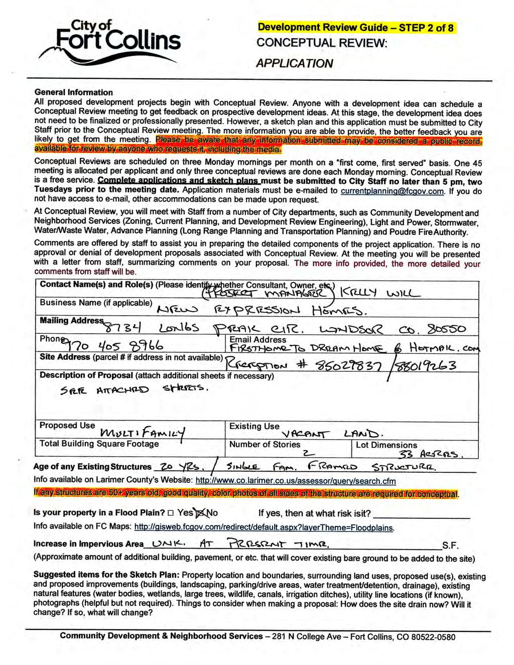
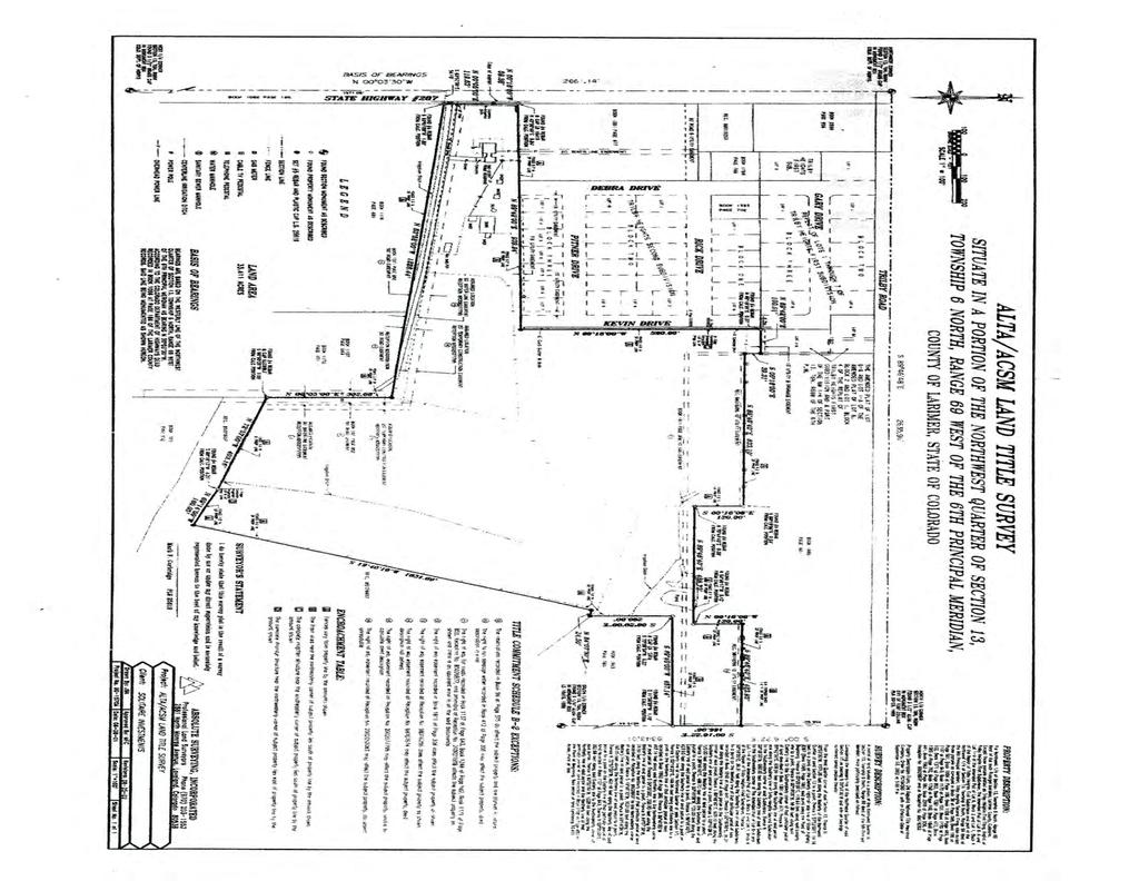
11 Development Review Guide STEP 2 of 8 CONCEPTUAL REVIEW: APPLICATION General Information All proposed development projects begin with Conceptual Review. Anyone with a development idea can schedule a Conceptual Review meeting to get feedback on prospective development ideas. At this stage, the development idea does not need to be finalized or professionally presented. However, a sketch plan and this application must be submitted to City Staff prior to the Conceptual Review meeting. The more information you are able to provide, the better feedback you are likely to get from the meeting. Please be aware that any information submitted may be considered a public record, available for review by anyone who requests it, including the media. Conceptual Reviews are scheduled on three Monday mornings per month on a first come, first served basis. One 45 meeting is allocated per applicant and only three conceptual reviews are done each Monday morning. Conceptual Review is a free service. Complete applications and sketch plans must be submitted to City Staff no later than 5 pm, two Tuesdays prior to the meeting date. Application materials must be ed to currentplanning@fcgov.com. If you do not have access to , other accommodations can be made upon request. At Conceptual Review, you will meet with Staff from a number of City departments, such as Community Development and Neighborhood Services (Zoning, Current Planning, and Development Review Engineering), Light and Power, Stormwater, Water/Waste Water, Advance Planning (Long Range Planning and Transportation Planning) and Poudre Fire Authority. Comments are offered by staff to assist you in preparing the detailed components of the project application. There is no approval or denial of development proposals associated with Conceptual Review. At the meeting you will be presented with a letter from staff, summarizing comments on your proposal. The more info provided, the more detailed your comments from staff will be. Contact Name(s) and Role(s) (Please identify whether Consultant, Owner, etc.) Business Name (if applicable) Mailing Address Phone Address Site Address (parcel # if address in not available) Description of Proposal (attach additional sheets if necessary) Proposed Use Existing Use Total Building Square Footage Number of Stories Lot Dimensions Age of any Existing Structures Info available on Larimer County s Website: If any structures are 50+ years old, good quality, color photos of all sides of the structure are required for conceptual. Is your property in a Flood Plain? Yes No If yes, then at what risk is it? Info available on FC Maps: Increase in Impervious Area S.F. (Approximate amount of additional building, pavement, or etc. that will cover existing bare ground to be added to the site) Suggested items for the Sketch Plan: Property location and boundaries, surrounding land uses, proposed use(s), existing and proposed improvements (buildings, landscaping, parking/drive areas, water treatment/detention, drainage), existing natural features (water bodies, wetlands, large trees, wildlife, canals, irrigation ditches), utility line locations (if known), photographs (helpful but not required). Things to consider when making a proposal: How does the site drain now? Will it change? If so, what will change? Community Development & Neighborhood Services 281 N College Ave Fort Collins, CO
12 405 MASON COURT, SUITE 115A FORT COLLINS, CO PHONE: (970) PROPERTY BOUNDARY (E) STAIRS REQUIRED PARKING SETBACK (E) LANDSCAPING ISLAND (E) EASEMENT (E) VEHICLE DISPLAY PARKING (E) EASEMENT PROPERTY BOUNDARY PROJECT: DELLENBACH DISPLAY PARKING FRONTAGE ROAD SOUTH COLLEGE AVENUE (E) PERMEABLE PARKING SURFACE (11) DISPLAY VEHICLES (E) FLEET SALES OFFICE 2,160 SQFT (6) CUSTOMER PARKING SPACES (E) VEHICLE DISPLAY PARKING 3121 SOUTH COLLEGE AVENUE, FORT COLLINS, CO SEAL: (E) CONCRETE WALKWAY DATE: FILE: 3/13/ :23:16 PM DRAWN BY: Author REVISION: \\TASSERVER\TAS Projects\ Dellenbach Subaru Expansion\Drawings\05 Fleet Sales\ Dellenbach Subaru - Parking Lot_RVT2018_CENTRAL.rvt (13) DISPLAY VEHICLES CONCEPTUAL DESIGN PROJECT NO: DRAWN BY: CHECKED BY: 0000 ISSUE AND REVISION SCHEDULE: FOOTHILLS PARKWAY DRAWING TITLE: EXISTING SITE PLAN NORTH 1 EXISTING SITE PLAN 1" = 20'-0" SHEET: A001
13 PROPERTY BOUNDARY 27'-1" 24'-9" SUMMARY OF PARKING REQUIREMENTS (E) STAIRS REQUIRED PARKING SETBACK 34'-0" (13) EXISTING DISPLAY VEHICLES = 110'-6" (4) EXISTING DISPLAY VEHICLES ADDRESS 3121 SOUTH COLLEGE AVENUE, FORT COLLINS, CO PARCEL NUMBER ZONING (NO CHANGE PROPOSED) GENERAL COMMERCIAL DISTRICT "C-G" T.O.D. OVERLAY ZONE USES (NO CHANGE PROPOSED) AUTOMOBILE SALES AND SERVICE 405 MASON COURT, SUITE 115A FORT COLLINS, CO PHONE: (970) AREA (SQFT) COVERAGE (%) LOT COVERAGE GROSS SITE AREA 41,252 SF - EXISTING BUILDING (FOOTPRINT) PROPOSED BUILDING (FOOTPRINT) 2,160 SF - 5.2% - EXISTING LANDSCAPING & WALKS 15,961 SF PROPOSED LANDSCAPING & WALKS 9,807 SF PARKING LOT PERIMETER LANDSCAPING 6,631 SF PARKING LOT INTERIOR LANDSCAPING (6% MIN.) 3,175 SF 38.7% 23.8% 16.1% 7.7% EXISTING PAVING PROPOSED PAVING 23,892 SF 33,133 SF 57.9% 80.3% BUILDING AREA EXISTING BLDG. FLOOR AREA PROPOSED BLDG. FLOOR AREA 2,160 SF - 5.2% - (E) LANDSCAPING ISLAND (E) EASEMENT 9'-0" (14) DISPLAY VEHICLES = 122'-6" 9'-0" (E) EASEMENT 19'-0" PARKING SPACES (STANDARD/ACCESSIBLE) EXISTING CUSTOMER PARKING PROPOSED VEHICLE DISPLAY (14) DISPLAY VEHICLES = 122'-6" SOUTH COLLEGE AVENUE 25'-8" 19'-0" 19'-0" 9'-0" FRONTAGE ROAD (14) DISPLAY VEHICLES = 122'-6" (11) EXISTING DISPLAY VEHICLES = 99'-0" 24'-0" LANDSCAPING ISLAND, TYPICAL 9'-0" 3/13/ :23:17 PM DRAWN BY: Author REVISION: \\TASSERVER\TAS Projects\ Dellenbach Subaru Expansion\Drawings\05 Fleet Sales\ Dellenbach Subaru - Parking Lot_RVT2018_CENTRAL.rvt (E, 5) PARKING LOT INTERIOR LANDSCAPING. AS REQUIRED IN SECTION 3.2.2(M)(1) ACCESS, CIRCULATION AND PARKING, SIX (6) PERCENT OF THE INTERIOR SPACE OF ALL PARKING LOTS WITH LESS THAN ONE HUNDRED (100) SPACES, AND TEN (10) PERCENT OF THE INTERIOR SPACE OF ALL PARKING LOTS WITH ONE HUNDRED (100) SPACES OR MORE SHALL BE LANDSCAPE AREAS. (SEE FIGURE 1). ALL PARKING LOT ISLANDS, CONNECTING WALKWAYS THROUGH PARKING LOTS AND DRIVEWAYS THROUGH OR TO PARKING LOTS SHALL BE LANDSCAPED ACCORDING TO THE FOLLOWING STANDARDS: (14) DISPLAY VEHICLES = 122'-6" FUTURE BUILDING ENVELOPE DATE: FILE: 59/1 97/ LANDSCAPING AND TREE PROTECTION 19'-0" PROPERTY BOUNDARY 24'-0" (E, 7) LANDSCAPING OF VEHICLE DISPLAY LOTS. VEHICLE DISPLAY LOTS FOR VEHICLE SALES AND LEASING (AS THOSE TERMS ARE DEFINED IN ARTICLE 5) THAT ABUT AN ARTERIAL OR COLLECTOR STREET SHALL FEATURE LANDSCAPED ISLANDS ALONG THE STREET AT AN INTERVAL NOT TO EXCEED EVERY FIFTEEN (15) VEHICLES OR ONE HUNDRED THIRTY-FIVE (135) FEET, WHICHEVER IS LESS. EACH LANDSCAPED ISLAND SHALL COMPLY WITH THE REQUIREMENTS OF SECTION 3.2.1(E)(5)(C). PROJECT: DELLENBACH DISPLAY PARKING 3121 SOUTH COLLEGE AVENUE, FORT COLLINS, CO SEAL: ACCESS, CIRCULATION, AND PARKING (J) SETBACKS. ANY VEHICULAR USE AREA CONTAINING SIX (6) OR MORE PARKING SPACES OR ONE THOUSAND EIGHT HUNDRED (1,800) OR MORE SQUARE FEET SHALL BE SET BACK FROM THE STREET RIGHT-OF-WAY AND THE SIDE AND REAR YARD LOT LINE (EXCEPT A LOT LINE BETWEEN BUILDINGS OR USES WITH COLLECTIVE PARKING) CONSISTENT WITH THE PROVISIONS OF THIS SECTION, ACCORDING TO THE FOLLOWING TABLE: (11) EXISTING DISPLAY VEHICLES = 117'-0" MINIMUM AVERAGE OF ENTIRE LANDSCAPE SETBACK AREA15 (FEET) ALONG AN ARTERIAL STREET ALONG A NONARTERIAL STREET 10 ALONG A LOT LINE 5 MINIMUM WIDTH OF SETBACK AT ANY POINT (FEET) (L) PARKING STALL DIMENSIONS. OFF-STREET PARKING AREAS FOR AUTOMOBILES SHALL MEET THE FOLLOWING MINIMUM STANDARDS FOR LONG-AND SHORTTERM PARKING OF STANDARD AND COMPACT VEHICLES: (1) STANDARD SPACES. PARKING SPACES FOR STANDARD VEHICLES SHALL CONFORM WITH THE STANDARD CAR DIMENSIONS SHOWN ON TABLE A. (2) COMPACT VEHICLE SPACES IN LONG-TERM PARKING LOTS AND PARKING STRUCTURES. THOSE AREAS OF A PARKING LOT OR PARKING STRUCTURE THAT ARE APPROVED AS LONG-TERM PARKING HAVE THE OPTION TO INCLUDE COMPACT PARKING STALLS. SUCH APPROVED LONG-TERM PARKING AREAS MAY HAVE UP TO FORTY (40) PERCENT COMPACT CAR STALLS USING THE COMPACT VEHICLE DIMENSIONS SET FORTH IN TABLE B, EXCEPT WHEN NO MINIMUM PARKING IS REQUIRED FOR A USE PURSUANT TO SUBSECTION (K), IN WHICH EVENT THE NUMBER OF COMPACT CAR STALLS ALLOWED MAY BE GREATER THAN FORTY (40) PERCENT. NO COMPACT SPACES SHALL BE DESIGNATED AS HANDICAP PARKING SPACES. FOOTHILLS PARKWAY CONCEPTUAL DESIGN PROJECT NO: DRAWN BY: CHECKED BY: 0000 ISSUE AND REVISION SCHEDULE: TABLE A - STANDARD VEHICLE ANGLE OF PARKING STALL WIDTH STALL LENGTH ONE-WAY AISLE WIDTH TWO-WAY AISLE WIDTH '-0" 8'-6" 8'-6" 9'-0" 9'-0" 23'-0" 20'-0" 20'-0" 19'-0' 19'-0" 20'-0" 20'-0" 20'-0" 24'-0" 24'-0" 12'-0" 15'-0" 15'-0' 20'-0" 20'-0" (3) LONG-TERM PARKING STALLS. AS AN OPTION IN LONG-TERM PARKING AREAS, ALL LONG-TERM PARKING STALLS MAY BE DESIGNATED USING THE FOLLOWING STALL DIMENSIONS: NORTH 1 SITE PLAN - LONG-TERM SPACING 1" = 20'-0" ANGLE OF PARKING STALL WIDTH STALL LENGTH '-0" 8'-0" 8'-0" 8'-6" 8'-6" 21'-0" 19'-0" 19'-0" 18'-0' 18'-0" DRAWING TITLE: SITE PLAN - PARKING LOT SHEET: DEFINITIONS: LONG-TERM PARKING SHALL MEAN PARKING WHICH HAS LIMITED TURNOVER DURING A NORMAL WORKING WEEKDAY. LONG-TERM PARKING INCLUDES EMPLOYEE-TYPE PARKING OR RESIDENTIAL-TYPE PARKING. A002


14 Taft Hill Lemay Timberline 2115 S Timberline Rd Dinner Theater Vicinity Map UV 14 «1 Douglas Mountain Vista Aerial Site Map Vine Mulberry Prospect Shields Drake Horsetooth ^_ Harmony Trilby Joseph Allen Dr 1 inch = 16,667 feet Bear Mountain Dr Zoning Map Kirkwood Dr MMN Bear Mountain Dr Dogwood Ct Joseph Allen Dr I Rushwood Ct Eastwood Dr E 1 inch = 250 feet Adobe Dr Nancy Gray Ave 1 inch = 208 feet These map products and all underlying data are developed for use by the City of Fort Collins for its internal purposes only, and were not designed or intended for general use by members of the public. The City makes no representation or warranty as to its accuracy, timeliness, or completeness, and in particular, its accuracy in labeling or displaying dimensions, contours, property boundaries, or placement of location of any map features thereon. THE CITY OF FORT COLLINS MAKES NO WARRANTY OF MERCHANTABILITY OR WARRANTY FOR FITNESS OF USE FOR PARTICULAR PURPOSE, EXPRESSED OR IMPLIED, WITH RESPECT TO THESE MAP PRODUCTS OR THE UNDERLYING DATA. Any users of these map products, map applications, or data, accepts same AS IS, WITH ALL FAULTS, and assumes all responsibility of the use thereof, and further covenants and agrees to hold the City harmless from and against all damage, loss, or liability arising from any use of this map product, in consideration of the City's having made this information available. Independent verification of all data contained herein should be obtained by any users of these products, or underlying data. The City disclaims, and shall not be held liable for any and all damage, loss, or liability, whether direct, indirect, or consequential, which arises or may arise from these map products or the use thereof by any person or entity.

15 Development Review Guide STEP 2 of 8 CONCEPTUAL REVIEW: APPLICATION General Information All proposed development projects begin with Conceptual Review. Anyone with a development idea can schedule a Conceptual Review meeting to get feedback on prospective development ideas. At this stage, the development idea does not need to be finalized or professionally presented. However, a sketch plan and this application must be submitted to City Staff prior to the Conceptual Review meeting. The more information you are able to provide, the better feedback you are likely to get from the meeting. Please be aware that any information submitted may be considered a public record, available for review by anyone who requests it, including the media. Conceptual Reviews are scheduled on three Monday mornings per month on a first come, first served basis. One 45 meeting is allocated per applicant and only three conceptual reviews are done each Monday morning. Conceptual Review is a free service. Complete applications and sketch plans must be submitted to City Staff no later than 5 pm, two Tuesdays prior to the meeting date. Application materials must be ed to currentplanning@fcgov.com. If you do not have access to , other accommodations can be made upon request. At Conceptual Review, you will meet with Staff from a number of City departments, such as Community Development and Neighborhood Services (Zoning, Current Planning, and Development Review Engineering), Light and Power, Stormwater, Water/Waste Water, Advance Planning (Long Range Planning and Transportation Planning) and Poudre Fire Authority. Comments are offered by staff to assist you in preparing the detailed components of the project application. There is no approval or denial of development proposals associated with Conceptual Review. At the meeting you will be presented with a letter from staff, summarizing comments on your proposal. The more info provided, the more detailed your comments from staff will be. Contact Name(s) and Role(s) (Please identify whether Consultant, Owner, etc.) Eric Larsen - General Contractor (if applicable) Evergreen Industrial Mailing Address 206 E. 4th Street, Suite 210, Loveland, CO Site Address (parcel # if address in not available) elarsen@evergreen-ind.com 2115 S TIMBERLINE RD FORT COLLINS, CO Description of Proposal (attach additional sheets if necessary) End user is planning to build a theater facility designed to serve the local Fort Collins art community. The theater will be approximately 10,000 sq ft and have the ability to host up to 250 people. The facility is currently being planned to exhibit many of the architectural features of the neighboring buildings in this park namely the Ascent climbing studio which promotes an innovative architectural metal panel on much of the exterior. Theater/Performing Arts Vacant Ground 10, ' x 214' Age of any Existing Structures N/A Info available on Larimer County s Website: If any structures are 50+ years old, good quality, color photos of all sides of the structure are required for conceptual. Is your property in a Flood Plain? Yes No If yes, then at what risk isit? Info available on FC Maps: Increase in Impervious Area approximately 23,000 S.F. (Approximate amount of additional building, pavement, or etc. that will cover existing bare ground to be added to the site) Suggested items for the Sketch Plan: Property location and boundaries, surrounding land uses, proposed use(s), existing and proposed improvements (buildings, landscaping, parking/drive areas, water treatment/detention, drainage), existing natural features (water bodies, wetlands, large trees, wildlife, canals, irrigation ditches), utility line locations (if known), photographs (helpful but not required). Things to consider when making a proposal: How does the site drain now? Will it change? If so, what will change? Community Development & Neighborhood Services 281 N College Ave Fort Collins, CO

16 Parking
17
Conceptual Review Agenda
 Conceptual Review Agenda Schedule for 10/23/17 to 10/23/17 281 Conference Room A Monday, October 23, 2017 Time Project Name Applicant Info Project Description Planner 9:30 Preston-Kelley Subdivision -
Conceptual Review Agenda
 Conceptual Review Agenda Schedule for 02/27/17 to 02/27/17 281 Conference Room A Monday, February 27, 2017 Time Project Name Applicant Info Project Description Planner 9:30 419 Wood Street Multi-Family
W Harmony Rd. Group Home
 Taft Hill Olt Ct Lemay Timberline Olt Ct 1109 W Harmony Rd Group Home 287 Vicinity Map «1 Douglas Aerial Site Map Wakerobin Ln 25 Mountain Vista Vine 287 Mulberry Prospect Shields Drake Horsetooth 25 ^_
1215 Shields Street Development PDR
 1215 Shields Street Development PDR Vicinity Map 287 Aerial Site Map Douglas 1 «V U 25 14 Mountain Vista Vine Mulberry Drake Lemay Shields Taft Hill Prospect Horsetooth Timberline _ ^ 287 University Ave
Conceptual Review Agenda
 Conceptual Review Agenda Schedule for 12/05/18 281 Conference Room A Wednesday, December 5, 2018 Time Project Name Applicant Info Project Description 8:30 Vine and Shields Multi-Family PDR180015 Todd Parker
Staybridge Suites. Aerial Site Map CCR POL. 1 inch = 17,493 feet. 1 inch = 250 feet. Vicinity Map. Zoning Map RL.
 Staybridge Suites Aerial Site Map 1 «2nd St 1st St 14 Vine Mulberry _ ^ U V Drake Lemay Prospect Shields Mountain Vista Buckingham Park Taft Hill Douglas Horsetooth Timberline 3rd St Vicinity Map E Lincoln
Drake Rd & College Ave Spradley Barr Redevelopmentl
 Taft Hill Lemay Timberline Frontage Rd Frontage Rd Drake Rd & College Ave Spradley Barr Redevelopmentl 287 Vicinity Map «1 Douglas Colorado 287 State University 25 Mountain Vista Vine Mulberry Bay Rd Aerial
Harmony Commons, Lot 1 Office
 Technology Pkwy Taft Hill Lemay Timberline Technology Pkwy Lady Moon Dr Harmony Commons, Lot Office Vicinity Map 87 UV 4 «Douglas Mountain Vista Aerial Site Map Vine 87 Mulberry Prospect Shields Drake
Conceptual Review Agenda
 Conceptual Review Agenda June 23, 2008 9:30 10:00 10:30 Project: Replat of Lots 13&16 Loomis Subdivision (Blk 267) Location: 429 Whitcomb (NW corner Whitcomb & Mulberry) Applicant: Craig Hughes Contact
Penny Flats North Mixed-Use Residential
 Taft Hill Lemay Timberline Penny Flats North Mixed-Use Residential 287 Vicinity Map «1 Douglas 25 Aerial Site Map Mountain Vista Lee Martinez Community Park ^_ 287 Vine Mulberry Prospect Shields Drake
^_ ^_. Sanctuary West UV 14 «1. Aerial Site Map. 1 inch = 16,667 feet. 1 inch RL= 1,042 feet. Vicinity Map. Zoning Map.
 Sitzman Way Briarwood Rd Briarwood Rd Taft Hill Lemay Timberline S Impala Dr Sanctuary West W Hartman St UE W Magnolia St Arlene Dr 287 Vicinity Map ^_ ^_ ^_ Cherry St Shields Zoning Map Sunrise Ln UV
Conceptual Review Agenda
 Conceptual Review Agenda May 11, 2009 9:30 10:00 10:30 11:00 11:30 Project: Orthopedic Center of the Rockies Expansion Location: 2500 E Prospect Applicant: Whitney Churchill Contact Info: 303-710-1937;
Conceptual Review Agenda
 Conceptual Review Agenda March 9, 2009 9:30 10:00 10:30 11:00 11:30 Project: Little Gadgets Daycare Center Church expansion to include café and events center Location: 363 Jefferson (Iasis Church) Applicant:
Preliminary Design Review. Poudre Garage Mixed Use December 14, 2015
 Preliminary Design Review December 14, 2015 1 Development Review Guide STEP 2 of 8 PRELIMINARY DESIGN REVIEW: APPLICATION General Information Preliminary design review is an opportunity for an applicant
Harmony Technology Park Third Filing, Second Replat Custom Blending, Project Development Plan/Final Development Plan - FDP #130021
 ITEM NO FDP #130021 MEETING DATE July 23, 2013 STAFF Pete Wray ADMINISTRATIVE TYPE I HEARING STAFF REPORT PROJECT: APPLICANT: OWNER: Harmony Technology Park Third Filing, Second Replat Custom Blending,
Conceptual Review Agenda
 Conceptual Review Agenda Schedule for 06/02/14 to 06/02/14 281 Conference Room A Monday, June 2, 2014 Time Project Name Applicant Info Project Description Planner 9:30 1005 Riverside Avenue - Office CDR140036
*BOLDED ITEMS ARE REQUIRED* *The more info provided, the more detailed your comments from staff will be.* Project Name
 Development Review Guide STEP 2 of 8 PRELIMINARY DESIGN REVIEW: APPLICATION General Information Preliminary design review is an opportunity for an applicant to discuss the requirements, standards, procedure,
Project phasing plan (if applicable) 12 copies of site plan
 12 copies of site plan") SITE PLAN REVIEW PERMIT APPLICATION City of Grand Haven, 11 N. Sixth Street, Grand Haven, MI 49417 Phone: (616) 847-3490 Fax: (616) 844-2051 Website: www.grandhaven.org 1. Project Information Address/location
SITE PLAN REVIEW PERMIT APPLICATION City of Grand Haven, 11 N. Sixth Street, Grand Haven, MI 49417 Phone: (616) 847-3490 Fax: (616) 844-2051 Website: www.grandhaven.org 1. Project Information Address/location
AWH REPORT OF THE PLANNING AND DEVELOPMENT DEPARTMENT FOR APPLICATION FOR REZONING ORDINANCE TO PLANNED UNIT DEVELOPMENT
 AWH REPORT OF THE PLANNING AND DEVELOPMENT DEPARTMENT FOR APPLICATION FOR REZONING ORDINANCE TO PLANNED UNIT DEVELOPMENT MAY 8, 2014 The Planning and Development Department hereby forwards to the Planning
GENERAL LANDSCAPE PROVISIONS. The following landscape provisions shall be adhered to by all land uses unless otherwise noted:
 CHAPTER 1.18 Sections: 1.18.005 Purpose. 1.18.010 Landscaping, Buffering, and Fencing Improvements Required. 1.18.015 General Landscape Provisions. 1.18.020 Landscaping Plan. 1.18.025 Single-Family Dwellings
Watertown City Council
 City of Watertown Watertown City Council April 14 th, 2015 Agenda Item: City Comment on Sun Share CUP Application Request for Action: Motion to Approve City Comments regarding CUP Application Department:
Conceptual Review Agenda
 Conceptual Review Agenda Schedule for 10/28/13 to 10/28/13 281 Conference Room A Monday, October 28, 2013 Time Project Name Applicant Info Project Description Planner 9:30 Aggie Village North Redevelopment
Design Review Application *Please call prior to submittal meeting to determine applicable fees*
 CITY OF EAGLE 660 E. Civic Lane, Eagle, ID 83616 Phone#: (208) 939-0227 Fax: (208) 938-3854 Design Review Application *Please call prior to submittal meeting to determine applicable fees* FILE NO.: CROSS
PLANNING COMMISSION. Agenda Item # 3
 PLANNING COMMISSION Agenda Item # 3 CASE SUMMARY Special Use Permit MEETING: Planning Commission, October 6, 2010 CASE NO: SITE ADDRESS: PROPOSAL: PRESENTED BY: STAFF RECOMMENDATION: SU-4-1010 406 S. 21st
Major Subdivision Sketch Plan Checklist
 This checklist provides specific requirements that are apart of the Sketch process. The entire process is described by the Huntersville Subdivision Review Process which details all the submittal and resubmittal
Jason Holland 4/8/2015 x. *BOLDED ITEMS ARE REQUIRED* *The more info provided, the more detailed your comments from staff will be.
 Development Review Guide STEP 2 of 8 PRELIMINARY DESIGN REVIEW: APPLICATION General Information Preliminary design review is an opportunity for an applicant to discuss the requirements, standards, procedure,
CITY PLANNING COMMISSION AGENDA ITEM: C STAFF: ROBERT TEGLER FILE NO: CPC PUD QUASI-JUDICIAL
 CPC AGENDA June 8, 2006 Page 37 CITY PLANNING COMMISSION AGENDA ITEM: C STAFF: ROBERT TEGLER FILE NO: CPC PUD 05-294 - QUASI-JUDICIAL PROJECT: APPLICANT: OWNER: PARKWOOD AT WOLF RANCH NASS DESIGN ASSOCIATES
Sanford/Lee County Technical Review Committee (TRC) DEADLINES & MEETING DATES
 DEADLINES & MEETING DATES") Sanford/Lee County Technical Review Committee (TRC) DEADLINES & MEETING DATES The following 2019 information is based on the information available to staff at the time of creation. Dates & time may change
Sanford/Lee County Technical Review Committee (TRC) DEADLINES & MEETING DATES The following 2019 information is based on the information available to staff at the time of creation. Dates & time may change
PLANNED UNIT DEVELOPMENT & SUBDIVISION STAFF REPORT Date: May 18, 2017
 & PUD-0000102-2017 PLANNED UNIT DEVELOPMENT & SUBDIVISION STAFF REPORT Date: May 18, 2017 NAME SUBDIVISION NAME Dauphin Creek Estates Subdivision Dauphin Creek Estates Subdivision LOCATION CITY COUNCIL
SUBMITTAL REQUIREMENTS
 WHEN PROCESS TYPE III IS USED References to Process Type III applications are found in several places in the Milton Municipal Code (MMC), indicating that the development, activity, or use, is permitted
 PLANNING COMMISSION STAFF REPORT MEETING DATE: PROJECT NUMBER: ZONE: REQUEST: ADDRESS: APPLICANT: PREPARED BY: 6 July 2017 D-17-006 Commercial Corridorr Design Review Approval a parking lot expansion 26
LANDSCAPE ORDINANCE PASADENA PLANNING DEPARTMENT (713) FAX (713)
 FAX (713)") LANDSCAPE ORDINANCE PASADENA PLANNING DEPARTMENT (713) 475-5543 FAX (713) 477-1072 ARTICLE X. LANDSCAPING OF NONRESIDENTIAL SITES* Sec. 9-195. Applicability. (a) This article shall apply to the following:
LANDSCAPE ORDINANCE PASADENA PLANNING DEPARTMENT (713) 475-5543 FAX (713) 477-1072 ARTICLE X. LANDSCAPING OF NONRESIDENTIAL SITES* Sec. 9-195. Applicability. (a) This article shall apply to the following:
City of Lafayette Study Session Staff Report Design Review Commission
 ++ City of Lafayette Study Session Staff Report Design Review Commission Meeting Date: January 08, 2018 Staff: Subject: Chris Juram, Planning Technician SS12-17 Miramar Homebuilders, R-20 Zoning: Request
ARTICLE IV: DEVELOPMENT STANDARDS 404 MASTER PLANNING
 IV 13 404 MASTER PLANNING Master Planning through the Site Analysis (Master Planning Site Analysis) or Planned Development (Master Planning Planned Development) is provided to encourage development which
CITY OF FORT COLLINS TYPE 1 ADMINISTRATIVE HEARING FINDINGS AND DECISION. CS Commercial, LLC 1337 Riverside Avenue, Unit 1 Fort Collins, CO 80524
 CITY OF FORT COLLINS TYPE 1 ADMINISTRATIVE HEARING FINDINGS AND DECISION HEARING DATE: January 7, 2016 PROJECT NAME: Caring Smiles Dental Clinic CASE NUMBER: FDP #150010 APPLICANT: OWNER: HEARING OFFICER:
Article 7.05 Manufactured Home Park Districts
 Article Manufactured Home Park Districts.01 Intent The purpose of the MHP Manufactured Home Park District is to give recognition to the fact that manufactured homes can provide satisfactory living conditions
PUBLIC WORKS - COMMUNITY DEVELOPMENT. Staff Report. Site Plan Review. SP July 5, 2018
 PUBLIC WORKS - COMMUNITY DEVELOPMENT 333 Broadalbin Street SW, PO Box 49, Albany, Oregon 97321-144 BUILDING 541-917-7553 PLANNING 541-917-755 Staff Report Site Plan Review SP-2-17 July 5, 218 Summary This
City of Lafayette Study Session Staff Report Design Review Commission
 City of Lafayette Study Session Staff Report Design Review Commission Meeting Date: April 24, 2017 Staff: Payal Bhagat, Senior Planner Subject: HDP18-15 & HDP31-15 Ramesh Patel & Melcor Development (Owners),
14825 Fruitvale Ave.
 REPORT TO THE PLANNING COMMISSION Meeting Date: August 26, 2015 Application: PDR14-0017 Location/APN: 14825 Fruitvale Ave. / 397-18-028 Applicant/Owner: Staff Planner: Sin Yong Michael Fossati 14825 Fruitvale
Mill Conversion Overlay District Zoning Bylaw Amendment
 Mill Conversion Overlay District Zoning Bylaw Amendment To see if the Town will vote to amend the Zoning By-Law by adding a new Section 13, Mill Conversion Overlay District, and by amending Sections 2.1,
CONCEPT PLAN APPLICATION
 CONCEPT PLAN APPLICATION TOWN OF CHAPEL HILL Planning Department 405 Martin Luther King Jr. Blvd phone (919) 968-2728 fa (919) 969-2014 www.townofchapelhill.org Parcel Identifier Number (PIN): 9880267455
SUBMITTAL REQUIREMENTS: FINAL PLAN REVIEW- PROJECT DEVELOPMENT PLAN (PDP)
") 1) Application form and filing fee. Application Form.pdf Development Review Guide STEP 6 of 8 SUBMITTAL REQUIREMENTS: FINAL PLAN REVIEW- PROJECT DEVELOPMENT PLAN (PDP) 2) Transportation Development Review
1) Application form and filing fee. Application Form.pdf Development Review Guide STEP 6 of 8 SUBMITTAL REQUIREMENTS: FINAL PLAN REVIEW- PROJECT DEVELOPMENT PLAN (PDP) 2) Transportation Development Review
4030 COMMERCIAL (C AND CM)
") 4030 COMMERCIAL (C AND CM) 4030.10 Intent and Purpose The C and CM districts are intended to permit the range of commercial uses in areas which are appropriate for such uses consistent with the General
4030 COMMERCIAL (C AND CM) 4030.10 Intent and Purpose The C and CM districts are intended to permit the range of commercial uses in areas which are appropriate for such uses consistent with the General
SEPA Modification Application
 SEPA Modification Application 6000 Main St. SW, Lakewood, WA 98499 Application Fee: $200.00 Number of Copies Required: Description of Required Documents: Required: A=always; M=may be 1 SEPA Modification
PLANNED UNIT DEVELOPMENT STAFF REPORT Date: June 2, 2016
 # 9 ZON2016-01032 PLANNED UNIT DEVELOPMENT STAFF REPORT Date: June 2, 2016 DEVELOPMENT NAME JJT Properties LLC LOCATION 1147 & 1151 East I-65 Service Road South and 1180 Sledge Drive (Southeast corner
E. Natural areas include habitats such as wetlands, tidal marshes, waterways, natural drainage-ways, woodlands and grassland meadows.
 Adopted November 1999 I. Purpose A. The purpose of these guidelines is to assist in the design and layout of open space, as provided on developed lots within the District. The intent of these guidelines
EXHIBIT B PROJECT NARRATIVE POULSBO MEADOWS
 EXHIBIT B PROJECT NARRATIVE POULSBO MEADOWS Name of Project: Poulsbo Meadows; A Planned Residential Development (PRD)/Plat Applicants Name: PBH Group LLC/Byron Harris PO Box 1010 Silverdale, WA 98038 Description
5.4 Development Incentives for All Commercial and Industrial Districts (except the TC: Town Center District).
.") 5.4 Development Incentives for All Commercial and Industrial Districts (except the TC: Town Center District). The following Development Incentives are provided in order to encourage flexibility and creativity
5.4 Development Incentives for All Commercial and Industrial Districts (except the TC: Town Center District). The following Development Incentives are provided in order to encourage flexibility and creativity
CITY PLANNING COMMISSION AGENDA. ITEM NO: 6.a 6.b STAFF: LONNA THELEN
 Page 156 CITY PLANNING COMMISSION AGENDA ITEM NO: 6.a 6.b STAFF: LONNA THELEN FILE NO(S): A. - CPC ZC 08-00069 QUASI-JUDICIAL B. - CPC CU 08-00070 QUASI-JUDICIAL PROJECT: APPLICANT: OWNER: PHIL LONG VALUCAR
CITY OF CYPRESS 5275 Orange Avenue Cypress, California (714) DESIGN REVIEW COMMITTEE PERMIT PROCESS
 DESIGN REVIEW COMMITTEE PERMIT PROCESS") CITY OF CYPRESS 5275 Orange Avenue Cypress, California 90630 (714) 229-6720 DESIGN REVIEW COMMITTEE PERMIT PROCESS 1. Discuss project with Planning staff to determine zoning regulations, any unusual characteristics
CITY OF CYPRESS 5275 Orange Avenue Cypress, California 90630 (714) 229-6720 DESIGN REVIEW COMMITTEE PERMIT PROCESS 1. Discuss project with Planning staff to determine zoning regulations, any unusual characteristics
CITY OF FORT COLLINS TYPE 1 ADMINISTRATIVE HEARING FINDINGS AND DECISION. Elevations Credit Union (2025 S. College Avenue)
") CITY OF FORT COLLINS TYPE 1 ADMINISTRATIVE HEARING FINDINGS AND DECISION HEARING DATE: September 28, 2016 PROJECT NAME: Elevations Credit Union (2025 S. College Avenue) CASE NUMBER: PDP #160021 APPLICANT:
CITY OF FORT COLLINS TYPE 1 ADMINISTRATIVE HEARING FINDINGS AND DECISION HEARING DATE: September 28, 2016 PROJECT NAME: Elevations Credit Union (2025 S. College Avenue) CASE NUMBER: PDP #160021 APPLICANT:
PART 1: PROJECT SUMMARY. Proposed Land Use: 120 single-family lots. The application is Attachment A. The site plan is Attachment B.
 PART 1: PROJECT SUMMARY Applicant: JBH Development, LLC and Hopper Communities, INC Project Size: +/- 80.48 acres Parcel Number: 01513107, 01513108, 01513109, 01513113, 01513120, 01513121, 01513122, 01513124,
A raised and landscaped median will be constructed in South College Avenue between Trilby Road and Skyway Drive.
 5.0 ACCESS CONTROL PLAN This section presents the Access Control Plan Update which has been formulated through the considerable input of the governing agencies, business owners, organized homeowner groups,
To encourage commercial development which is consistent with the long range, comprehensive, general plan for Knoxville and Knox County.
 Page 1 of 5 9. - C-6 general commercial park district. A. Legislative purpose, intent and application. The legislative purpose, intent and application of the general commercial park development [district]
DEPARTMENT OF PLANNING JEFFERSON PARISH, LOUISIANA
 DEPARTMENT OF PLANNING JEFFERSON PARISH, LOUISIANA DESIGN REVIEW REPORT : CPZ-3-1 : (S) Cynthia Lee-Sheng AT LARGE: A Chris Roberts B Elton M. Lagasse ADVERTISING DATES: 06/03/1 06/10/1 06/17/1 PAB PUBLIC
ARTICLE 13 STREETS General
 ARTICLE 13 STREETS 13.1 General Streets shall be designed to suit their functions. Many streets have purposes other than vehicular traffic. As an alternative to current N.C. Department of Transportation
SECTION 1 CLEARING /GRADING PERMIT APPLICATION:
 PLEASE REFER TO THE CLEARING & GRADING PERMIT CHECKLIST BELOW FOR SUBMITTAL REQUIREMENTS. SECTION 1 CLEARING /GRADING PERMIT APPLICATION: PROJECT ADDRESS (Street, Suite #): Parcel(s) #: Total Site Area
Agenda Report Meeting Date 11/02/16. Architectural Review (Wildwood Estates Townhomes)
") Architectural Review and Historic Preservation Board Agenda Report Meeting Date 11/02/16 REPORT DATE: October 24, 2016 File: AR 16-19 TO: FROM: RE: Architectural Review and Historic Preservation Board
Architectural Review and Historic Preservation Board Agenda Report Meeting Date 11/02/16 REPORT DATE: October 24, 2016 File: AR 16-19 TO: FROM: RE: Architectural Review and Historic Preservation Board
14 October 10, 2012 Public Hearing APPLICANT: MPB, INC
 14 October 10, 2012 Public Hearing APPLICANT: MPB, INC PROPERTY OWNER: MUNDEN & ASSOCIATES, LP STAFF PLANNER: Karen Prochilo REQUEST: Conditional Change of Zoning (AG-1 & AG-2 to Conditional O-2) ADDRESS
PLANNED DEVELOPMENT (MASTER PLAN & UNIT PLAN)
") Central Permit Center 555 Santa Clara Street Vallejo CA 94590 Business License Building Fire Prevention Planning Public Works 707.648.4310 707.648.4374 707.648.4565 707.648.4326 707.651.7151 PLANNED DEVELOPMENT
Central Permit Center 555 Santa Clara Street Vallejo CA 94590 Business License Building Fire Prevention Planning Public Works 707.648.4310 707.648.4374 707.648.4565 707.648.4326 707.651.7151 PLANNED DEVELOPMENT
DCA , Stormwater Quality and Facilities Ordinance June 23, 2009
 PROPOSED NEW SECTION 10.486 Stormwater Quality and Detention Facilities, Public Streets. A. Purpose. It is the City s policy to maintain the natural hydrology and preserve water quality by mitigating the
South Commercial and Rural Fringe Land Use East Rural Fringe Land Use West - Planned Community (Pace Island)
") Revised 11/2/2015 Owners Name: Agent: G & H International Investments LLC 1890 Kingsley Avenue Suite 102 Orange Park, FL 32073 Susan L. Fraser, SLF Consulting, Inc. 3517 Park Street Jacksonville, FL 32205
Revised 11/2/2015 Owners Name: Agent: G & H International Investments LLC 1890 Kingsley Avenue Suite 102 Orange Park, FL 32073 Susan L. Fraser, SLF Consulting, Inc. 3517 Park Street Jacksonville, FL 32205
419 Canyon Ave, Suite 200 Fort Collins, CO 80521
 HEARING DATE 11.2.2015 STAFF Mapes ADMINISTRATIVE PUBLIC HEARING STAFF REPORT PROJECT: Southeast Community Park, PDP # 140014 APPLICANT: OWNER: Ripley Design, Inc. 419 Canyon Ave, Suite 200 Fort Collins,
MIAMI 21 SEPTEMBER 2015 APPENDIX J: NEIGHBORHOOD REVITALIZATION DISTRICTS TABLE OF CONTENTS J.1. NEIGHBORHOOD REVITALIZATION DISTRICT NRD-1
 TABLE OF CONTENTS J.1. NEIGHBORHOOD REVITALIZATION DISTRICT NRD-1 1.1 Boundaries J.3 1.2 Intent J.3 1.3 Effect of District Designation J.3 1.4 Additional Notice and Review J.3 1.5 Wynwood Thoroughfares
FOR MEETING OF: DECEMBER 18, 2018 CASE NO.: DR-CU-SPR-DAP18-06 AGENDA ITEM: 6.1 PLANNING COMMISSION LISA ANDERSON-OGILVIE, AICP PLANNING ADMINISTRATOR
 FOR MEETING OF: DECEMBER 18, 2018 CASE NO.: DR-CU-SPR-DAP18-06 AGENDA ITEM: 6.1 TO: FROM: PLANNING COMMISSION LISA ANDERSON-OGILVIE, AICP PLANNING ADMINISTRATOR SUBJECT: DESIGN REVIEW CONDITIONAL USE SITE
PLANNED UNIT DEVELOPMENT Date: April 5, 2018
 PLANNED UNIT DEVELOPMENT Date: April 5, 2018 DEVELOPMENT NAME SUBDIVISION NAME LOCATION Robert Myers Robert Myers 2955 and 2989 Dauphin Street (Southeast corner of Dauphin Street and Sage Avenue) CITY
R E S O L U T I O N. Single-Family Residence/ Church. 2,488 sq. ft. 2,488 sq. ft. Area Parking Required: Church
 R E S O L U T I O N WHEREAS, the Prince George s County Planning Board is charged with the approval of Detailed Site Plans pursuant to Part 3, Division 9 of the Zoning Ordinance of the Prince George s
NOTICE OF PREPARATION
 NOTICE OF PREPARATION DATE: January 6, 2016 TO: LEAD AGENCY: Responsible Agencies, Organizations, and Interested Parties Contact: Tyler Barrington, Principal Planner Planning Department Community Development
ARTICLE V PLANNED UNIT DEVELOPMENT DISTRICT
 ARTICLE V PLANNED UNIT DEVELOPMENT DISTRICT A. Purpose and Objective The Planned Unit Development (PUD) procedure provides a flexible land use and design regulation through the use of performance criteria
Plat Requirements CHECKLIST FOR SITE PLAN REVIEW
 This checklist is to be used as a guide for complying with the Town of Hollis Site Plan Regulations. It is to be used for each individual site plan review application submitted. Applicants are encouraged
Application for Site Plan Review
 Application for Site Plan Review City of Pontiac Office of Land Use and Strategic Planning 47450 Woodward Ave, Pontiac, MI 48342 T: 248.758.2800 F: 248.758.2827 Property/Project Address: Sidwell Number:
STANDARDS THAT APPLY TO ALL OR SOME DEVELOPMENT PROJECTS WITH RESIDENTIAL USES
 6 STANDARDS THAT APPLY TO ALL OR SOME DEVELOPMENT PROJECTS WITH RESIDENTIAL USES STANDARDS THAT APPLY TO ALL OR SOME DEVELOPMENT PROJECTS WITH RESIDENTIAL USES 6-1 Figure 6-1: Parking Stall Width 9 Stall
ARTICLE 17 SITE PLAN REVIEW
 ARTICLE 17 SITE PLAN REVIEW 17.01 INTENT AND PURPOSE The intent of this section is to provide for consultation and cooperation between the applicant and the township planning commission so that the applicant
D1 September 11, 2013 Public Hearing APPLICANT:
 D1 September 11, 2013 Public Hearing APPLICANT: BEACH MUNICIPAL FEDERAL CREDIT UNION PROPERTY OWNER: SISTERS II, LLC STAFF PLANNER: Karen Prochilo REQUEST: Conditional Change of Zoning (AG-2 Agriculture
CITY OF ZEELAND PLANNING COMMISSION
 APPLICATION FOR SITE PLAN REVIEW AND SPECIAL LAND USE Date City Official App. Filing Fee Rec'd ($350) NOTE TO APPLICANT: Please submit this application for Site Plan Review along with twenty (20) copies
Chesapeake Bay Critical Area Conservation Plan
 The Maryland-National Capital Park and Planning Commission Prince George s County Planning Department Development Review Division 301-952-3530 Note: Staff reports can be accessed at www.mncppc.org/pgco/planning/plan.htm.
COMMUNITY DEVELOPMENT DEPARTMENT 333 Broadalbin Street SW, P.O. Box 490 Albany, OR 97321
 COMMUNITY DEVELOPMENT DEPARTMENT Broadalbin Street SW, P.O. Box 0 Albany, OR NOTICE OF FILING Ph: --0 Fax: -- www.cityofalbany.net DATE OF NOTICE: February, 0 FILE: SP-0- TYPE OF APPLICATION: Site Plan
Conceptual Review Agenda
 Conceptual Review Agenda July 21, 2008 9:30 10:00 10:30 11:00 11:30 Project: Romero Park Community Center Location: 10 th Street, south of Romero, south of Museo de las Tres Colonias Applicant: Betty Aragon-Mitates
Conceptual Review Agenda
 Conceptual Review Agenda Schedule for /11/18 281 Conference Room A Thursday, October 11, 2018 Time Project Name Applicant Info Project Description 9:30 Montava Max Moss This is a request to develop 850
Site Development Plan (SDP) Checklist
 Checklist") Development Services Department 100 N. Wilcox Street, Castle Rock CO 80104 303-660-1393 or CRGov.com Site Development Plan (SDP) Checklist A complete Site Development Plan (SDP) submittal will contain
Development Services Department 100 N. Wilcox Street, Castle Rock CO 80104 303-660-1393 or CRGov.com Site Development Plan (SDP) Checklist A complete Site Development Plan (SDP) submittal will contain
CHAPTER 22 Rural Open Space Community Developments
 CHAPTER 22 Rural Open Space Community Developments Section 22.1 Description and Purpose The intent of this Chapter is to offer property owners an alternative to traditional zoning requirements for rural
Request Alternative Compliance to the prescribed criteria of the Oceanfront Resort District Form-Based Code. Staff Planner Kristine Gay
 Applicant/Owner Ocean Rental Properties, LLC Public Hearing April 13, 2016 City Council Election District Beach Agenda Item 1 Request Alternative Compliance to the prescribed criteria of the Oceanfront
City of Yelm. Tahoma Terra Final Master Plan Development Guidelines. Table of Contents
 City of Yelm Tahoma Terra Final Master Plan Development Guidelines Table of Contents Table of Contents... 1 Purpose... 2 Low Density Residential (R4-6)... 3 Moderate Density Residential (R6-10)... 5 Neighborhood
MEDWAY PLANNING BOARD MINOR SITE PLAN PROJECTS Application Guidelines
 Revised August 28, 2006 A. Procedure MEDWAY PLANNING BOARD MINOR SITE PLAN PROJECTS Application Guidelines 1) Before submitting a formal site plan application, prospective applicants are encouraged to
A Guide to Open Space Design Development in Halifax Regional Municipality
 A uide to Open Space Design Development in Halifax Regional Municipality May 2007 1 Introduction Pursuant to Section 3.5 of the Regional Municipal Planning Strategy (RMPS), subdivision of land may proceed
Landscape and fencing requirements of this Chapter shall apply to all new landscaped areas.
 Chapter 19.06. Landscaping and Fencing. Sections: 19.06.01. Purpose. 19.06.02. Required Landscaping Improvements. 19.06.03. General Provisions. 19.06.04. Landscaping Plan. 19.06.05. Completion of Landscape
#8) T-1409 CENTENNIAL & LAMB TENTATIVE MAP
 T-1409 CENTENNIAL & LAMB TENTATIVE MAP") #8) T-1409 CENTENNIAL & LAMB TENTATIVE MAP STAFF REPORT To: Planning Commission Meeting Date: June 14, 2017 Item: T-1409 Prepared By: Robert Eastman GENERAL INFORMATION: Applicant: Property Owner(s): Requested
#8) T-1409 CENTENNIAL & LAMB TENTATIVE MAP STAFF REPORT To: Planning Commission Meeting Date: June 14, 2017 Item: T-1409 Prepared By: Robert Eastman GENERAL INFORMATION: Applicant: Property Owner(s): Requested
Section 511: 11 th Street Overlay District 1. Intent: 11 th Street is the primary entrance route into the city from the south, providing direct
 Section 511: 11 th Street Overlay District 1. Intent: 11 th Street is the primary entrance route into the city from the south, providing direct access from US Highway 12. As such, the community has identified
GD, Green Zone Planned Development District
 ARTICLE 24.00 Section 24.01 Statement of Purpose The Green Zone Planned Development District (the Green Zone ) is a diverse mixed use zoning district created to guide development of a portion of the Grand
VILLAGES AT RIVERDALE
 VILLAGES AT RIVERDALE PD STANDARDS Case #Z 2016-005 Prepared For: Prepared By: Oakwood Homes, LLC Terracina Design 4908 Tower Rd 10200 E Girard Ave #A-314 Denver, CO 80249 Denver, CO 80231 (303) 486-8500
Kingfisher Planned Development (PLNSUB ) and Special Exception (PLNPCM ) Planned Development and Special Exception
 and Special Exception (PLNPCM ) Planned Development and Special Exception") Staff Report PLANNING DIVISION COMMUNITY & ECONOMIC DEVELOPMENT To: From: Salt Lake City Planning Commission Maryann Pickering, Principal Planner (801) 535-7660 Date: October 22, 2014 Re: Kingfisher Planned
Staff Report PLANNING DIVISION COMMUNITY & ECONOMIC DEVELOPMENT To: From: Salt Lake City Planning Commission Maryann Pickering, Principal Planner (801) 535-7660 Date: October 22, 2014 Re: Kingfisher Planned
2. Would the proposed project comply with the Land Use map? 3. Would the proposed project require a rezoning? 4. What is the proposed zoning district?
 TOWN OF CHAPEL HILL Planning and Sustainability Department 405 Martin Luther King Jr. Blvd. Chapel Hill, NC 27514 www.townofchapelhill.org phone (919) 968 2728 Concept Plans are intended to be an opportunity
Staff Report Bourbon County Joint Planning Office SPECIAL MEETING September 4, 2018
 Staff Report Bourbon County Joint Planning Office SPECIAL MEETING September 4, 2018 Case Number: DVP 18-05 FINAL Applicant: Josh Cummins Location: Arlington Drive. Request: Car Dealer Parking Lot Zoning:
Town of West Point Plan of Development
 Town of West Point Plan of Development Plan Submission In accordance with Section 70-51(b) of the Town Code, the Zoning Administrator shall establish a written policy for the form, format, content and
DRAFT ETC Master Plan. Appendix D Land Uses and Demographics
 DRAFT ETC Master Plan Appendix D Land Uses and Demographics DRAFT ETC Master Plan Figure D 1. Existing Land Uses... D 3 Figure D 2. Future Land Uses... D 5 Figure D 3. Transportation Analysis Zones...
ARTICLE 3. LARGE-SCALE SOLAR PHOTOVOLTAIC INSTALLATIONS SECTION XXI
 ARTICLE 3. LARGE-SCALE SOLAR PHOTOVOLTAIC INSTALLATIONS SECTION XXI 1.1 PURPOSE The purpose of this by-law is to regulate the installation of solar photovoltaic installations that are to produce 250 kw
Asbury Chapel Subdivision Sketch Plan
 Asbury Chapel Subdivision Sketch Plan PART 1: PROJECT SUMMARY Applicant: NVR Inc. Project Size: +/- 76.13 acres Parcel Numbers: 02101112,02116101,02116112, 02116113 Current Zoning: Transitional Residential
The purpose of the requirements in this Article is to provide for landscaping and screening of parking and other outdoor areas that will:
 XIII. LANDSCAPING & SCREENING A. Purpose The purpose of the requirements in this Article is to provide for landscaping and screening of parking and other outdoor areas that will: 1. Protect residential
CITY COUNCIL STUDY SESSION MEMORANDUM
 City and County of Broomfield, Colorado CITY COUNCIL STUDY SESSION MEMORANDUM To: From: Prepared by: Mayor and City Council Charles Ozaki, City and County Manager Kevin Standbridge, Deputy City and County
12 January 12, 2011 Public Hearing APPLICANT: TAILWIND DEVELOPMENT GROUP,LLC PROPERTY OWNER: CITY OF VIRGINIA BEACH
 12 January 12, 2011 Public Hearing APPLICANT: TAILWIND DEVELOPMENT GROUP,LLC PROPERTY OWNER: CITY OF VIRGINIA BEACH STAFF PLANNER: Faith Christie REQUEST: Conditional Change of Zoning (from PD-H1 Planned