Conceptual Review Agenda
|
|
|
- Jonas Shaw
- 5 years ago
- Views:
Transcription
1 Conceptual Review Agenda Schedule for /11/ Conference Room A Thursday, October 11, 2018 Time Project Name Applicant Info Project Description 9:30 Montava Max Moss This is a request to develop 850 acres in the northwest area of Fort Planner Clay Frickey (512) Collins roughly bound by Vine Dr on the south, Turnberry Rd on the CDR18007 max@hf2m.com west, the Budweiser brewery on the east and Richards Lake Rd on the north (parcel # , , , DRC Tenae Beane , , , ). The land is Angela Milewski (970) currently undeveloped. The plan to develop the property includes a mix of housing, schools, parks, commercial center, employment, amilewski@bdadesign.com natural areas and agriculture. Conceptual planning is using an estimate of about 5,000 dwelling units. Project planning to date has included neighborhood meetings, a week-long charrette and a transportation report. The proposed project includes portions of the following zone districts: Low-Density Mixed-Use (), Employment (E), and Industrial (I). The proposed project with go through the new PUD process which will require Planning and Zoning Board (Type 2) Review. :15 Timberline Annexation Jon Jacobs (970) and Subdivision jon.cbc1@gmail.com CDR This is a request to annex and subdivide a parcel at the intersection of South Timberline Rd and East Lincoln (parcel # ). The existing parcel, which is divided into three separate parts by Timberline Road and a ditch, will be subdivided to create new lots where these parcel divisions currently exist. Industrial (I) and Employment (E) zoning is indicated at this site by the City s Structure Plan Map. This proposal will be subject to Annexation and Initial Zoning followed by Administrative (Type I) review for the subdivision. Planner DRC Pete Wray Brandy BH 11:00 Southridge Verizon WTE CDR Shawn Turk (720) turks@bv.com This is a request to install new wireless antennas and ground support equipment at Southridge Golf Course (parcel # ). There is an existing driving range net pole at the location and it would be replaced with a new pole approximately 54 high to accommodate the antennas within a cannister. Ground equipment would be concealed within a ½ x 19 ½ foot enclosure with siding to match existing buildings. The proposed project is within the Public Open Lands (POL) zone district and is subject to Administrative (Type 1) review. Planner DRC Clark Mapes Todd Sullivan Agenda as of /03/18 at 11:00 am Page 1 of 1


 Future")
2 E Taft Hill Giddings Rd Lemay Timberline Busch Dr Forecastle Dr Milton Ln Busch Dr Ashland Ln Thoreau Dr Giddings Rd Interstate 25 Montava Highland Dr Kenyon Dr Richards Abbotsford St Inverness Rd Lake Rd Gregory Rd 287 Vicinity Map Hearthfire Dr Bateleur Ln Town Richard's Lake ^_ ^_ ^_ UV 14 «1 Center Dr 287 Prospect Shields Drake Horsetooth Jua nita Rd ^_ Douglas S e ^_ Richards Lake Park Morningstar Way Beam ^_ ^_ ^_ rramonte Dr Reach Pl 25 Mountain Vista Vine Mulberry 25 Richards Lake Rd Turnberry Rd Brightwater Dr Mainsail Dr Clipper Way Ballard Ln E Douglas Rd N County Road 9 Richards Lake Rd Aerial Site Map Nw Frontage Rd Franklin Rd Farnell Rd Ridgecrest Rd Club View Rd Long Pond Harmony Cottonwood Point Dr Frontage Rd Crescent Park Sage Dr Redwood St Mullein Dr 2nd St Cottonwood Dr Greenbriar Park Foxtail St Tavelli Elementary 287 Proposed (mountain Vista Site) Future Northeast Community Park Alta Vista Park E Future Streets Facility CC Park 3rd St W estview Rd Sitka St ll Ln L owe Clipper Way Crescent Park Turnberry Rd Buckingham St Main St MMN Buckingham Park E E Cache la Poudre River Hillside Ct Forest Hills Zoning Map Ballard Ln Cambria Ln N Lemay Ave Clark St MMN Romero Park N Lemay Ave MMN Trilby Linden Lake Rd Lindenmeier Lake L Gold Dr Ln CC MMN Jay Dr Duff Dr 12th St Country Club Hillside Dr indenwood Dr N Link Ln Webster Ave E Olive Ct Miramont Dr Link Lane Ct Nedrah Dr Racquette Dr Rd Dayton Dr E Lincoln Ave Lake View Dr A 25 1 inch = 1,7 feet Richards Lake Rd I I E T T Heath Pkwy Sunbury Ln Proposed (mountain Vista Site) Future Northeast Community Park Chesapeake Dr drie Dr l Future Iron Horse Park Winamac Dr Celtic Ln Rabbit Brush Park Proposed (vine Site) Mackinac St Daine Dr Airway Ave E Vine Dr Ne Frontage Rd!"`$!"`$ Redman Dr Maid Marian Ct Turnberry Rd UE Lager St Heritage Christian Academy UE Airway Ave 1 inch = 4,0 feet Mandarin Saison St Rosybill Dr Dr Sunday Dr Jay Dr International Blvd Steven Dr N Timberline Rd Rd S Timberline Barnstormer St Biplane St Conquest Sykes E Vine Dr Dr St Comet St Crusader St Roselawn Cemetery Mountain Vista Dr Future Trail Head Park Celtic Ln Rabbit Brush Park Glenloch Dr Glenwall Dr Weicker Dr Berwick Ct Redman Dr 1 inch = 2,417 feet These map products and all underlying data are developed for use by the City of Fort Collins for its internal purposes only, and were not designed or intended for general use by members of the public. The City makes no representation or warranty as to its accuracy, timeliness, or completeness, and in particular, its accuracy in labeling or displaying dimensions, contours, property boundaries, or placement of location of any map features thereon. THE CITY OF FORT COLLINS MAKES NO WARRANTY OF MERCHANTABILITY OR WARRANTY FOR FITNESS OF USE FOR PARTICULAR PURPOSE, EXPRESSED OR IMPLIED, WITH RESPECT TO THESE MAP PRODUCTS OR THE UNDERLYING DATA. Any users of these map products, map applications, or data, accepts same AS IS, WITH ALL FAULTS, and assumes all responsibility of the use thereof, and further covenants and agrees to hold the City harmless from and against all damage, loss, or liability arising from any use of this map product, in consideration of the City's having made this information available. Independent verification of all data contained herein should be obtained by any users of these products, or underlying data. The City disclaims, and shall not be held liable for any and all damage, loss, or liability, whether direct, indirect, or consequential, which arises or may arise from these map products or the use thereof by any person or entity.
3 Development Review Guide STEP 2 of 8 CONCEPTUAL REVIEW: APPLICATION General Information All proposed land development projects begin with Conceptual Review. Anyone with a land development idea can schedule a Conceptual Review meeting to get feedback on prospective development ideas. At this stage, the development idea does not need to be finalized or professionally presented. However, a sketch plan or site plan and this application must be submitted to City Staff prior to the Conceptual Review meeting. The more information you are able to provide, the better feedback you are likely to get from the meeting. Generally, Conceptual Review works best after a brief conversation with a representative from the Zoning or Planning Department to first establish compliance with the permitted uses under the applicable zone district. Then a sketch plan or site plan is prepared that allows staff to review and provide comments on the land development aspects of the proposal. Please be aware that any information submitted may be considered a public record, and may be made available to anyone who requests it, including the media. The applicant acknowledges that that they are acting with the owner's consent. Conceptual Reviews are scheduled on three Thursday mornings per month on a first come, first served basis. One 45 meeting is allocated per applicant and only three conceptual reviews are held each Thursday morning. Conceptual Review is a free service. Complete applications and sketch plans must be submitted to City Staff no later than 5 pm, two Tuesdays prior to the meeting date. Application materials must be ed to currentplanning@fcgov.com. If you do not have access to , other accommodations can be made upon request. At Conceptual Review, you will meet with Staff from various City departments, including Community Development and Neighborhood Services (Zoning, Planning, and Development Review Engineering), Light and Power, Stormwater, Water/ Waste Water, Transportation Planning and Poudre Fire Authority. Staff provides the applicant with comments to assist in preparing the detailed formal project application. There is no approval or denial of development proposals associated with Conceptual Review. The applicant will receive the comment letter at the review meeting. *BOLDED ITEMS ARE REQUIRED* *The more info provided, the more detailed your comments from staff will be.* Contact Name(s) and Role(s) (Please identify whether Consultant or Owner, etc) Max Moss, HF2M (Developer) and Angela Milewski, BHA Design (Consultant) Business Name (if applicable) HF2M, BHA Design Your Mailing Address BHA Design, 3 Oakridge Drive Suite 0, Fort Collins, CO Phone Number (512) , Address Max@hf2m.com, amilewski@bhadesign.com (970) Site Address or Description (parcel # if no address) parcels , , , , , , Description of Proposal (attach additional sheets if necessary) Montava PUD Master Plan (mixed use PUD master plan, see attached narrative for PUD concept) Proposed Use Mixed Use PUD Overlay Zoning Existing Use undeveloped I, E, Zoning Total Building Square Footage tbd S.F. Number of Stories tbd Lot Dimensions tbd Age of any Existing Structures unknown Info available on Larimer County s Website: If any structures are 50+ years old, good quality, color photos of all sides of the structure are required for conceptual. Is your property in a Flood Plain? Yes No If yes, then what risk level? Info available on FC Maps: tbd, see plans and narrative for PUD concept Increase in Impervious Area S.F. (Approximate amount of additional building, pavement, or etc. that will cover existing bare ground to be added to the site) Suggested items for the Sketch Plan: Property location and boundaries, surrounding land uses, proposed use(s), existing and proposed improvements (buildings, landscaping, parking/drive areas, water treatment/detention, drainage), existing natural features (water bodies, wetlands, large trees, wildlife, canals, irrigation ditches), utility line locations (if known), photographs (helpful but not required). Things to consider when making a proposal: How does the site drain now? Will it change? If so, what will change? Community Development & Neighborhood Services 281 N College Ave Fort Collins, CO
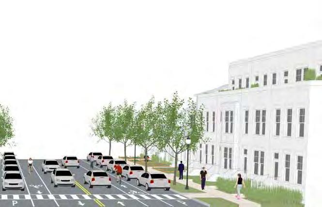
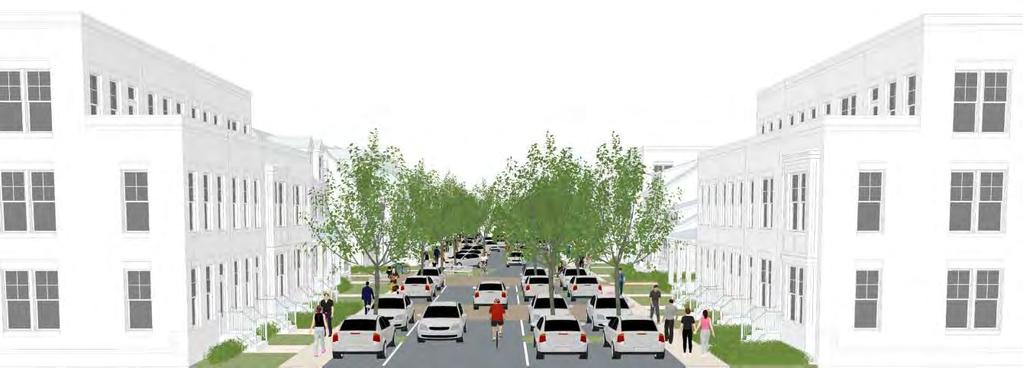
4 Montava PUD Master Plan Conceptual Review Application Narrative October 2, 2018 The Montava Master Plan is the result of an unprecedented collaborative effort over the past several months. The developer, HF2M has been working with Anhueser-Busch to redevelop the nearly 850-acre parcel west of the current brewery. HF2M is taking this opportunity to plan a true TND community with an integrated mix of uses including housing, employment, schools, parks, natural areas and agriculture. Montava has been planned in a comprehensive way with early engagement of city staff, utility providers, adjacent landowners, and subject experts. The process began in 2017 with an initial neighborhood meeting with nearly 0 attendees, and a week-long design charette including multiple topic meetings, three public presentations, seven interim plans and a final master plan. Since that time, we have continued to coordinate with agencies and stakeholders to develop more detailed information on relevant issues including: - Scoping and preparing traffic studies to support a Master Street Plan amendment (including a second neighborhood meeting focused on this topic) - Locations for future schools for Poudre School District - Coordination with stormwater utilities regarding conveyance of off-site drainage and their longrange plans for this area - Assessment of land for the 40-acre organic farm - Coordination with Park Planning and Natural Areas staff on how the plan can best support their long-term goals for the area - Developing strategies for affordable and attainable housing The design team includes national and international experts in Traditional Neighborhood Design, agriurban developments, transportation planning and affordable housing design and construction. These experts have teamed together with local design and engineering consultants, market experts, and technology leaders to create a comprehensive planning approach. Proposed Uses: Montava will be a true mixed-use community encompassing every form of housing, mixed use community service retail, schools, employment and light industrial use. Existing improvements and uses: The land is currently 0% agricultural Describe the site circulation: See attached plans and diagrams Describe the site design and architecture: Montava is intended to be developed as a true TND community providing a true walkable community based on traditional neighborhood forms. The architecture is intended to be a mixture, but calling on the history of what has made Colorado special. If you were to look at the architectural inspiration, I would say look no further than traditional downtown Fort Collins historical architecture. It will also be inspired by the history of agriculture in the area, while incorporating a working 40-acre organic farm as part of that overall development.
5 How is the proposal compatible with the surrounding area: Our goal with Montava is to serve as an extension of the heart of Fort Collins. The residential community will be compatible with all the surrounding existing and planned areas. The town center is intended to serve the entire NE sub area with services including grocery and others. The transportation plan is grid-based and efficient to support the entire Mountain Vista area. Describe water detention: Our engineers with Martin and Martin have been working closely with the city staff to develop a plan that works with the surrounding regional detention and conveyance needs. The primary conveyance and detention occur along the east side of the site providing opportunities for both functional and natural features. The No. 8 canal is planned to remain and be improved as a natural feature while conveying ditch and stormwater flows. There are also smaller areas of drainage conveyance and detention incorporated throughout the plan. Does the proposal impact natural features: As the current land use is farming, the natural features of the area will certainly change. One large tree near the east side of the site has been identified to remain and to be incorporated into the natural areas and drainage conveyance. In addition, we intend to incorporate agriculture and Nature in the City concepts throughout the project. Do any existing structures have automatic fire sprinklers? None of the existing structures have fire sprinklers, nor will they remain with the future plans. New structures will have fire sprinklers as per building code requirements. Are there any unusual factors and/or characteristics present that may restrict or affect your proposal? There are many unusual factors that may restrict or impede our proposal. The lack of services provided by the city of Fort Collins to the area are significant factors. The lack of physical infrastructure (transportation) to the area may restrict the proposal. The land itself does not pose much challenge. Have you previously submitted and application? Prior to the adoption of the PUD process, we previously submitted PDR application in advance of a planned ODP and rezoning. We are happy to now pursue the PUD Master Plan application process as it seems to be a good fit for review of this level of planning for Montava.
6 FORT COLLINS FARM LLC. STATE OF COLORADO NO. 8 DITCH LIND SUBDIVISION RICHARDS LAKE ROAD (CR 52) 3 Oakridge Drive Fort Collins, CO p. (970) RICHARDS LAKE ROAD (CR 52) PUD BOUNDARY PUD BOUNDARY Landscape Architecture Urban Design Master Planning MAPLE HILL PARK EXT. BUILDING, TYP. GRAVEL ROAD IRRIGATION DITCH 2 IRRIGATION DITCH 3 WETLAND 3 WETLAND 2 PUD BOUNDARY I-25 NORTH BOUND I-25 SOUTH BOUND BUSCH DR. PUD BOUNDARY MAPLE HILL SUBDIVISION C&S RAILROAD CENTER PIVOT ACCESS ROAD IRRIGATION DITCH 1 NORTH GIDDINGS ROAD TURNBERRY ROAD (CR 11) ANHEUSER BUSCH LLC. Revision & Date: ANHEUSER BUSCH LLC CITY OF FORT COLLINS EXISTING TREE WITH ACTIVE RED-TAIL HAWK NEST TEMPORARY 450' LOD RADIUS COUNTRY CLUB ROAD BU MOUNTAIN VISTA DRIVE (CR 50) MOUNTAIN VISTA DRIVE (CR 50). CONSTRUCTION SHALL BE ORGANIZED AND TIMED TO MINIMIZE THE DISTURBANCE OF SENSITIVE SPECIES OCCUPYING OR USING ON-SITE AND ADJACENT NATURAL HABITATS OR FEATURES. 8. BY PDP PROJECT HEARING: CONFIRMATION UNITED STATES ARMY CORPS OF ENGINEERS (USACE) JURISDICTIONAL DETERMINATION PROCESS HAS BEGUN; ESSENTIALLY THAT USACE HAS BEEN CONTACTED AND DATA SUBMITTED. 9. BY PDP FINAL PLAN AND NO LATER THAN DEVELOPMENT CONSTRUCTION PERMIT (DCP): DOCUMENTATION OF JURISDICTIONAL DETERMINATION LETTER FROM USACE AND SIGN_OFF THAT PROJECT MEETS CLEAN WATER ACT REQUIREMENTS BY DEVELOPMENT AGREEMENT (DA): WEED MANAGEMENT AND NHBZ ANNUAL MONITORING PLANS PRIOR TO ISSUANCE OF DCP: COPY OF NATIONWIDE 404 PERMIT DOCUMENTATION. PRIOR TO ISSUANCE OF DCP: 1) ENVIRONMENTAL PLANNING APPROVED SECURITY BASED ON 125% COST OF ITEMIZED LIST OF NHBZ INSTALLATION COSTS (MATERIAL AND LABOR); 2) SECURITY BASED ON 125% COST OF WEED MANAGEMENT AND ANNUAL MONITORING REPORT AC (1,350.3 SF) 3 IRRIGATION DITCH AC (1, SF) 4 IRRIGATION DITCH AC (1,55.28 SF) 5 IRRIGATION DITCH AC (2, SF) WETLAND AC (18,295.2 SF) 7 WETLAND AC (31,33.2 SF) 8 WETLAND AC (13,08.0 SF) 9 WETLAND 4/NO 8 DITCH AC (35, SF) IRRIGATION DITCH 5 K AND M CO. IRRIGATION DITCH 4 50' 50' OVERHEAD POWER ESMT. 0' SANITARY SEWER ESMT. PUD BOUNDARY L&W CANAL MONTAVA IRRIGATION DITCH 2 HF2M Client: WATERGLEN SUBDIVISION PUD BOUNDARY H ITC CONSTRUCTION OF BARRIER FENCING SHALL BE PROVIDED AT THE LIMITS OF THE DEVELOPMENT DURING CONSTRUCTION. 2 8D AC (479.1 SF) I-25 NORTH BOUND SEE SECTION OF THE LAND USE CODE FOR ALLOWABLE USES WITHIN THE BUFFER ZONE. IRRIGATION DITCH 1 I-25 SOUTH BOUND 5. 1 C&S RAILROAD STANDARDS FOR PROTECTION DURING CONSTRUCTION - THE DIRECTOR SHALL ESTABLISH A "LIMITS OF DEVELOPMENT" ("LOD") LINE(S) TO ESTABLISH THE BOUNDARY OF THE PROJECT OUTSIDE OF WHICH NO LAND DISTURBANCE ACTIVITIES WILL OCCUR DURING THE CONSTRUCTION OF THE PROJECT. SIZE: AC (SF). NO Plot Date:/2/ :08 PM Plotted By: Aaron Wagner Date Created:9/18/2018 L:\PROJECTS\MONTAVA\DWGS\ACAD\PUD\DWG\PUD_EX-COND-PLAN.DWG 4. PLEASE SEE SECTION OF THE LAND USE CODE FOR ALLOWABLE USES WITHIN THE NATURAL HABITAT BUFFER ZONES. NAME WETLAND 1 0 ' 3. A SITE VISIT MAY BE NECESSARY TO DETERMINE WHICH FEATURES REQUIRE DOCUMENTATION AND BUFFERING ON THE PUD. APPROX. SQUARE FOOTAGES OF NATURAL FEATURES WITHIN PUD AREA (AS DETERMINED BY ERO: ECOLOGICAL CHARACTERIZATION SURVEY, JUNE 27, 2018) PUD BOUNDARY 2. THIS PLANNED UNIT DEVELOPMENT PLAN SHOWS THE GENERAL LOCATION AND APPROXIMATE SIZE OF ALL NATURAL AREAS, HABITATS, AND FEATURES WITHIN ITS BOUNDARIES AND THE PROPOSED ROUGH ESTIMATE OF THE NATURAL AREA BUFFER ZONES AS REQUIRED BY LAND USE CODE SECTION 3.4.1(E). DETAILED MAPPING OF THE SITE'S NATURAL AREAS, HABITATS, AND FEATURES WILL BE PROVIDED AT THE TIME OF INDIVIDUAL PDP SUBMITTALS. GENERAL BUFFER ZONES SHOWN ON THIS PUD MAY BE REDUCED OR ENLARGED BY THE DECISION MAKER DURING THE PUD PROCESS." NORTH TIMBERLINE ROAD 1. NATURAL FEATURES SQ FT. TABLE PUD MASTER PLAN PUD BOUNDARY NATURAL HABITATS AND FEATURES NOTES S PUD BOUNDARY 50' BUFFER ZONE FROM IRRIGATION DITCH STORYBROOK SUBDIVISION Project: EXT. GRAVEL ROAD. DR H C EX CONDITIONS & NATURAL FEATURES 0' 0' SANITARY SEWER ESMT. NORTH GIDDINGS ROAD NO. 8 DITCH TURNBERRY ROAD (CR 11) PUD BOUNDARY POUDRE R-1 SCHOOL DISTRICT MONTAVA PUD BOUNDARY L& WC AN A L Project Number: 1734 Date: /2/2018 Produced by: AKM Sheet Number: 2

7 RICHARDS LAKE RD Civic Building T5 Town Center Building T5 Town Center Employment T5 Urban Center Neighborhood T4 General Urban Neighborhood T3 Sub-urban Neighborhood T2 Rural Neighborhood Industrial Land Revision & Date: Parks, Schools, Open Space Natural Areas & Stormwater PSD ELEMENTARY SCHOOL TURNBERRY RD Farm Client: HF2M MONTAVA PUD MASTER PLAN OVERALLMASTER UTILITY PLAN OVERALL PLAN MONTAVA N GIDDINGS RD PSD HIGH SCHOOL INTERSTATE 25 MOUNTAIN VISTA DR N TIMBERLINE RD Plot Date:9/13/2018 :34 AM Plotted By: Matthew Lambert Date Created:9/13/2018 /USERS/MATT/ELC/SHARED/PROJECTS-2015_2019/1725-MONTAVA/ FILES/1725-MASTERPLAN/01-RESOURCE/TITLE_BLOCK/PUD_SUBMITTAL/24X3_TITLE_BLOCK_PUD_CONSULTANT.DWG Project: CITY OF FORT COLLINS PARK PSD MIDDLE SCHOOL Project Number: 1734 Date: X.X.XXX 09/13/18 DPZ CODESIGN Produced by: X.X. Sheet Number:

8 RICHARDS LAKE RD T5 Urban Center / Mixed-use T4 General Urban Neighborhood T3 Sub-urban Neighborhood T2 Rural Neighborhood Agricultural City Park & Open Space Poudre School District Natural Areas & Stormwater Industrial & Employment Revision & Date: TURNBERRY RD PSD ELEMENTARY SCHOOL Client: HF2M MONTAVA PUD MASTER PLAN OVERALL UTILITY PLAN ZONING MONTAVA N GIDDINGS RD PSD HIGH SCHOOL INTERSTATE 25 MOUNTAIN VISTA DR N TIMBERLINE RD Plot Date:9/13/2018 :34 0 AM Plotted 200 By: Matthew 400 Lambert ,00 Date Created:9/13/2018 /USERS/MATT/ELC/SHARED/PROJECTS-2015_2019/1725-MONTAVA/ FILES/1725-MASTERPLAN/01-RESOURCE/TITLE_BLOCK/PUD_SUBMITTAL/24X3_TITLE_BLOCK_PUD_CONSULTANT.DWG Project: CITY OF FORT COLLINS PARK PSD MIDDLE SCHOOL Project Number: 1734 Date: X.X.XXX 09/13/18 DPZ CODESIGN Produced by: X.X. Sheet Number:


9 ARTERIAL ROADWAYS Revision & Date: Mountain Vista from Turnberry to Giddings, Phase 1 Right-of-way: 115 Roadway: 5 1 2a Mountain Vista from Turnberry to Giddings, Phase 2 Right-of-way: 115 Roadway: 84 3 Giddings from Mountain Vista north, optional median Right-of-way: 93 Roadway: 1 2b Mountain Vista from Giddings eastward Right-of-way: 115 Roadway: 84 3 Giddings from Mountain Vista north; Mountain Vista from Timberline westward; Turnberry from Montain Vista to Country Club Rd Right-of-way: 84 Roadway: 52 Project: MONTAVA Client: HF2M Plot Date:9/13/2018 :34 AM Plotted By: Matthew Lambert Date Created:9/13/2018 /USERS/MATT/ELC/SHARED/PROJECTS-2015_2019/1725-MONTAVA/ FILES/1725-MASTERPLAN/01-RESOURCE/TITLE_BLOCK/PUD_SUBMITTAL/24X3_TITLE_BLOCK_PUD_CONSULTANT.DWG 3 3 5b 5b 5a b 8 8 5b 4 5b 5b b 3 5b b 5b 1/2a 2b 8 7b 8 7b , COLLECTOR ROADWAYS T5 and T4 land use context <- -> T3 and T2 land use context Minor Collector Right-of-way: 80 Roadway: 54 # ROW ROADWAY TYPE 1 [115] [5] 2-lane Arterial (phase 1) 2 [115] [84] 4-lane Arterial 3 [84-93] [54-1] 2-lane Arterial 4 [80] [54] Minor Collector 5a [82] [52] Commercial Local 5b [] [3] Commercial Local [50-0] [27-30] Residential Local [0] [3] Connector Local 7b [ exl. Green] [48] Connector Local w/ Green 8 [8 + Green] [40 exl. Green] Local Paired w/ Green 9 [] [44] Industrial Local [51] [Varies] Home Zone MONTAVA STREET OVERALL TYPES UTILITY AND LOCATIONS PLAN PUD MASTER PLAN Project Number: 1734 Date: X.X.XXX /01/18 Produced by: X.X. DPZ CODESIGN Sheet Number:


 Right-of-way: 50")
 Right-of-way: Roadway: 3")


10 LOCAL ROADWAYS Revision & Date: T5 and T4 land use context <- -> T3 and T2 land use context T4 and T3 land use context <- -> T2 land use context 5a Commercial Local (with bike lanes) Right-of-way: 82 Roadway: 52 Connector Local Right-of-way: 0 Roadway: 3 Residential Local (with alley) Right-of-way: 50 Roadway: 27 5b Commercial Local (without bike lanes) Right-of-way: Roadway: 3 Residential Local (without alley) Right-of-way: 53 Roadway: 30 8 Industrial Local Right-of-way: Roadway: 44 Project: MONTAVA Client: HF2M SPECIAL LOCAL ROADWAY CONDITIONS Plot Date:9/13/2018 :34 AM Plotted By: Matthew Lambert Date Created:9/13/2018 /USERS/MATT/ELC/SHARED/PROJECTS-2015_2019/1725-MONTAVA/ FILES/1725-MASTERPLAN/01-RESOURCE/TITLE_BLOCK/PUD_SUBMITTAL/24X3_TITLE_BLOCK_PUD_CONSULTANT.DWG 7b 8 T5 land use context <- -> T4 and T3 land use context Connector Local with an Attached Green Right-of-way: Roadway: 48 T5 land use context <- -> T4 and T3 land use context Local Paired around a Green Right-of-way: Varies Roadway: 40 Home Zone Right-of-way: 51 Roadway: Varies MONTAVA STREET OVERALL TYPES UTILITY AND LOCATIONS PLAN PUD MASTER PLAN Project Number: 1734 Date: X.X.XXX /01/18 Produced by: X.X. DPZ CODESIGN Sheet Number:


11 Taft Hill Lemay Timberline Countryside Dr Countryside Dr Timberline Annexation and Subdivision Vicinity Map 287 Airway Ave «1 UV Prospect Douglas ^_ Morocco Way 25 Mountain Vista Vine ^_ Mulberry Zurich Dr Mexico Way London Ct Munich Way Heritage Christian Academy Rome Ct Aerial Site Map International Blvd N Timberline Rd Vicot Way Crusader St Racquette Dr Shields Drake Horsetooth Harmony 25 Donella Ct S Summit View Dr Trilby Donella Ct E Lincoln Ave Airpark Dr 287 Heath Pkwy Christman Dr 25 1 inch = 19,081 feet Airway Ave S Summit View Dr Zoning Map Donella Ct Industrial Dr S Summit View Dr E Lincoln Ave E Donella Ct S Summit View Dr Frontage Rd «14 E Mulberry St Frontage Rd Airway Ave E Lincoln Ave «14 S Timberline Rd CG Cache la Poudre River «14 Frontage Rd E Lincoln Ave E Mulberry St 1 inch = 7 feet S Timberline Rd Wiper Pond Cairnes Dr Turtle Pond Eric St Joanne St Darren St Trout Pond Max St Andrea St Darren Ct Bluegill Pond Cherly St 1 inch = 00 feet These map products and all underlying data are developed for use by the City of Fort Collins for its internal purposes only, and were not designed or intended for general use by members of the public. The City makes no representation or warranty as to its accuracy, timeliness, or completeness, and in particular, its accuracy in labeling or displaying dimensions, contours, property boundaries, or placement of location of any map features thereon. THE CITY OF FORT COLLINS MAKES NO WARRANTY OF MERCHANTABILITY OR WARRANTY FOR FITNESS OF USE FOR PARTICULAR PURPOSE, EXPRESSED OR IMPLIED, WITH RESPECT TO THESE MAP PRODUCTS OR THE UNDERLYING DATA. Any users of these map products, map applications, or data, accepts same AS IS, WITH ALL FAULTS, and assumes all responsibility of the use thereof, and further covenants and agrees to hold the City harmless from and against all damage, loss, or liability arising from any use of this map product, in consideration of the City's having made this information available. Independent verification of all data contained herein should be obtained by any users of these products, or underlying data. The City disclaims, and shall not be held liable for any and all damage, loss, or liability, whether direct, indirect, or consequential, which arises or may arise from these map products or the use thereof by any person or entity.

12
13


14 S Lemay Ave Compton Rd Taft Hill Lemay Timberline Southridge Golf Course Wireless Telecommunications Equipment Werner Elementary Vicinity Map Roma Valley Ct Highcastle Dr 287 Napa Valley Dr Roma Valley Dr «1 Milan Terrace Dr Belvedere Ct Douglas Belvedere Pl 25 Pinnacle Pl Mountain Vista Oak Leaf Ct Seton St Southridge Golf Course Aerial Site Map Fairway Five Dr Fairway ix Dr S ^_^_^_ ^_ ^_ ^_^_^_ E Milan Terrace Dr Fossil Creek Pkwy Skyway Dr Zoning Map Pinnacle Pl Southri dge Greens Hamilton Ct Yarnell Ct Huntington Blvd Dearborn St Parliament Ct Portner Reservoir Seton St POL Hills Fossil Creek Community Park Portner Reservoir Dr UV Prospect Shields Drake Horsetooth Harmony ^_ Trilby 287 Normandy Ct Vine Mulberry ^_ Southridge Golf Course Wingfoot Dr Melrose Ct Nightingale Dr 25 1 inch = 18,885 feet Hummel Dr Front Nine Southridge Golf Course Fairway Six Dr Ln Hiwan Ct Greenridge Cir POL Ashton Ct 25 Condor Dr Southridge Greens Blvd Pheasant Ct Doral Pl Deercroft Ct Muirfield Way Wingfoot Dr Pheasant Dr Southridge Golf Course Paragon Pl Chickadee Ct Fron Paragon Ct t Nine Dr Hummel Ln Glen Greenridge Cir Hiwan Ct Ea gle Ct Cactus Ct Huntington Hills Dr Buchanan St Pheasant Dr Cattail Ct Paragon Pl RL Marshall St Prescott St Cactus Ct Buchanan St Victoria Rd Golden Willow Dr 1 inch = 1,417 feet Buchanan Ct S Lemay Ave Cliffrose Ct Cattail Ct Eagle Falcon Ridge Ct Ridge Ct 1 inch = 7 feet These map products and all underlying data are developed for use by the City of Fort Collins for its internal purposes only, and were not designed or intended for general use by members of the public. The City makes no representation or warranty as to its accuracy, timeliness, or completeness, and in particular, its accuracy in labeling or displaying dimensions, contours, property boundaries, or placement of location of any map features thereon. THE CITY OF FORT COLLINS MAKES NO WARRANTY OF MERCHANTABILITY OR WARRANTY FOR FITNESS OF USE FOR PARTICULAR PURPOSE, EXPRESSED OR IMPLIED, WITH RESPECT TO THESE MAP PRODUCTS OR THE UNDERLYING DATA. Any users of these map products, map applications, or data, accepts same AS IS, WITH ALL FAULTS, and assumes all responsibility of the use thereof, and further covenants and agrees to hold the City harmless from and against all damage, loss, or liability arising from any use of this map product, in consideration of the City's having made this information available. Independent verification of all data contained herein should be obtained by any users of these products, or underlying data. The City disclaims, and shall not be held liable for any and all damage, loss, or liability, whether direct, indirect, or consequential, which arises or may arise from these map products or the use thereof by any person or entity.

15 Development Review Guide STEP 2 of 8 CONCEPTUAL REVIEW: APPLICATION General Information All proposed land development projects begin with Conceptual Review. Anyone with a land development idea can schedule a Conceptual Review meeting to get feedback on prospective development ideas. At this stage, the development idea does not need to be finalized or professionally presented. However, a sketch plan or site plan and this application must be submitted to City Staff prior to the Conceptual Review meeting. The more information you are able to provide, the better feedback you are likely to get from the meeting. Generally, Conceptual Review works best after a brief conversation with a representative from the Zoning or Planning Department to first establish compliance with the permitted uses under the applicable zone district. Then a sketch plan or site plan is prepared that allows staff to review and provide comments on the land development aspects of the proposal. Please be aware that any information submitted may be considered a public record, and may be made available to anyone who requests it, including the media. The applicant acknowledges that that they are acting with the owner's consent. Conceptual Reviews are scheduled on three Thursday mornings per month on a first come, first served basis. One 45 meeting is allocated per applicant and only three conceptual reviews are held each Thursday morning. Conceptual Review is a free service. Complete applications and sketch plans must be submitted to City Staff no later than 5 pm, two Tuesdays prior to the meeting date. Application materials must be ed to currentplanning@fcgov.com. If you do not have access to , other accommodations can be made upon request. At Conceptual Review, you will meet with Staff from various City departments, including Community Development and Neighborhood Services (Zoning, Planning, and Development Review Engineering), Light and Power, Stormwater, Water/ Waste Water, Transportation Planning and Poudre Fire Authority. Staff provides the applicant with comments to assist in preparing the detailed formal project application. There is no approval or denial of development proposals associated with Conceptual Review. The applicant will receive the comment letter at the review meeting. *BOLDED ITEMS ARE REQUIRED* *The more info provided, the more detailed your comments from staff will be.* Contact Name(s) and Role(s) (Please identify whether Consultant or Owner, etc) Shawn Turk, Consultant on behalf of Verizon Wireless Business Name (if applicable) Black & Veatch Your Mailing Address 400 S. Syracuse Street, Denver, CO Phone Number Address turks@bv.com Site Address or Description (parcel # if no address) APN Description of Proposal (attach additional sheets if necessary) Installation of new wireless antennas, with support equipment on an existing driving range pole at the Southridge Golf Course. Pole will be swapped for a new pole to support equipment, with antennas concealed in a canister above the existing pole. Proposed Use Wireless Facility Existing Use Golf Course Total Building Square Footage S.F. Number of Stories Lot Dimensions Age of any Existing Structures Not applicable Info available on Larimer County s Website: If any structures are 50+ years old, good quality, color photos of all sides of the structure are required for conceptual. Is your property in a Flood Plain? Yes x No If yes, then what risk level? Info available on FC Maps: Increase in Impervious Area Approximately 235 square feet S.F. (Approximate amount of additional building, pavement, or etc. that will cover existing bare ground to be added to the site) Suggested items for the Sketch Plan: Property location and boundaries, surrounding land uses, proposed use(s), existing and proposed improvements (buildings, landscaping, parking/drive areas, water treatment/detention, drainage), existing natural features (water bodies, wetlands, large trees, wildlife, canals, irrigation ditches), utility line locations (if known), photographs (helpful but not required). Things to consider when making a proposal: How does the site drain now? Will it change? If so, what will change? Community Development & Neighborhood Services 281 N College Ave Fort Collins, CO

16 ANTENNAS PENETRATIONS EXISTING CONDITIONS SITE NAME: SITE ADDRESS: VICINITY MAP FTC ROMA VALLEY PROJECT NEW BUILD - CONCEPT OPTION S. LEMAY AVE. FT. COLLINS, CO DRAWING INDEX VERIZON WIRELESS SERVICES 3131 S. VAUGHN WAY, SUITE 550 AURORA, CO PROJECT INFORMATION SITE NAME FTC ROMA VALLEY 5750 S. LEMAY AVE. FT. COLLINS, CO CONSULTANT SHEET DESCRIPTION LEASE AREA EXISTING EASEMENT S. LEMAY AVE. SITE E. TRILBY RD. SOUTHRIDGE GOLF COURSE SERVICE RD. I-25 T1.0 TITLE SHEET LS1 LS2 TOPOGRAPHIC SURVEY (DRAFT) TOPOGRAPHIC SURVEY (DRAFT) A1.0 SITE PLAN A2.0 ENLARGED PLANS A3.0 EAST ELEVATION A3.1 SOUTH ELEVATION A 09/13/18 CONCEPT SMV ACCESS/UTILITY EASEMENT GEN. CONST./UTILITY EASEMENT OVP/ELEC. EQ. POWER/GROUNDING NOT TO SCALE DIRECTIONS FROM DENVER I-25 NORTH (51 MILES) EXIT 22, CO-392 (5 MILES) RIGHT ON S. LEMAY AVE (1 MILE) GOLF COURSE MAINTENANCE RD. IS ON THE RIGHT AFTER E. TRILBY RD. SITE IS ON THE SIDE OF THE FAIRWAY NORTH OF THE MAINTENANCE RD. PROJECT DATA 392 JURISDICTION CITY OF FT. COLLINS APN ZONING DESIGNATION PUBLIC OPEN LANDS DISTRICT 51 MILES N 1st REVIEW SGP 2nd REVIEW 5935 SOUTH ZANG STREET, SUITE 280 LITTLETON, COLORADO OFFICE: ERR BBU/RRH MW/FIBER EQ. HYBRID & COAX CABLES FIBER PROJECT DESCRIPTION REPLACE EXISTING GOLF COURSE NET POLE WITH NEW MONOPOLE () NEW VERIZON WIRELESS ANTENNAS WITHIN NEW SHROUD NEW EQUIPMENT ENCLOSURE WITH VERIZON WIRELESS EQUIPMENT NEW UNDERGROUND ELECTRICAL SERVICE NEW UNDERGROUND FIBER SERVICE PROJECT TEAM OWNER CITY OF FORT COLLINS TYLER MARR PHONE: CLIENT VERIZON WIRELESS CONSTRUCTION ENGINEER KENT McDERMOTT 3131 S. VAUGHN WAY SUITE 550 AURORA CO, CELL: SITE ACQUISITIONIST BLACK & VETCH SHAWN TURK 400 S. SYRACUSE STREET SUITE 800 DENVER, CO PHONE: RF ENGINEER VERIZON WIRELESS RAM NANDIRAJU 3131 S. VAUGHN WAY SUITE 550 AURORA, CO PHONE: ARCHITECT CSAi CHARLES STECKLY,AIA 5935 S. ZANG STREET SUITE 280 LITTLETON, CO CELL: OFFICE: NEW CONSTRUCTION OCCUPANCY GROUP CONSTRUCTION TYPE FULLY SPRINKLERED NO. STORIES U V-B N/A N/A GOVERNING CODES: 2015 IBC, 2015 IFC, 2015 IMC, 2015 IECC, 2017 NEC A.D.A. COMPLIANCE THIS FACILITY IS UNMANNED AND NOT FOR HUMAN HABITATION SURVEYOR PRECISION SURVEYING & MAPPING 9145 KENYON AVE SUITE 1 DENVER, CO PHONE: NOT FOR CONSTRUCTION TITLE SHEET T1.0

17
18
19 ANTENNAS PENETRATIONS S. LEMAY AVE. (E) LAWN (E) 35' NETTING POLE (TYP) (E) ' UTILITY EASEMENT RE: SURVEY NEW GOLF COURSE NETTING ATTACHED TO NEW VERIZON WIRELESS POLE NEW 54'H MONOPOLE W/ () NEW VERIZON WIRELESS ANTENNAS RE: 2/A2.0 VERIZON WIRELESS SERVICES 3131 S. VAUGHN WAY, SUITE 550 AURORA, CO PROJECT INFORMATION SITE NAME FTC ROMA VALLEY 5750 S. LEMAY AVE. FT. COLLINS, CO LEASE AREA EXISTING EASEMENT (E) NET POLE TO BE REMOVED (E) SIDEWALK ROUTE COAX FROM RRHS THROUGH "Ø U.G. CONDUITS TO ANTENNAS IN NEW VERIZON WIRELESS 'W UTILITY EASEMENT RE: SURVEY (APPROX. 80 L.F.) NEW U.G. FIBER IN 2"Ø CONDUIT W/ 3-CELL MAXCELL INNERDUCT IN NEW 'W VERIZON WIRELESS UTILITY EASEMENT (APPROX. 25 L.F.) CONSULTANT A 09/13/18 CONCEPT SMV ACCESS/UTILITY EASEMENT GEN. CONST./UTILITY EASEMENT (E) TREE TO REMAIN (TYP) NEW FIBER HAND HOLE/MMP (FINAL LOCATION T.B.D.) NEW 12'-"x21'-" VERIZON WIRELESS LEASE AREA RE: 1/A2.0 NEW VERIZON WIRELESS EQUIPMENT SHELTER WITH OUTDOOR EQUIPMENT WITHIN RE: 1/A2.0 A3.0 1 (E) HOLE SIGNAGE ON CONC. PAD (E) TREE TO REMAIN 1st REVIEW SGP 2nd REVIEW ERR (E) RIGHT OF WAY 1 A3.1 OVP/ELEC. EQ. POWER/GROUNDING (E) PROPERTY LINE APPROX. LOCATION RE: SURVEY (PENDING) NEW U.G. ELEC. SERVICE CONDUIT IN NEW 'W VERIZON WIRELESS UTILITY EASEMENT (APPROX. 40 L.F.) (E) PROPERTY LINE NEW 15'W VERIZON WIRELESS ACCESS EASEMENT TO (E) SERVICE ROAD R.O.W. RE: SURVEY 5935 SOUTH ZANG STREET, SUITE 280 LITTLETON, COLORADO OFFICE: BBU/RRH MW/FIBER EQ. HYBRID & COAX CABLES FIBER NEW 75KVA TRANSFORMER (E) SERVICE ROAD 1-SITE PLAN 1" = 20'-0" (E) FAIRWAY NOT FOR CONSTRUCTION SITE PLAN A1.0
20 ANTENNAS PENETRATIONS (3) NEW 8'H ANTENNAS ATTACHED TO STEEL MAST 'Z' SECTOR AZIMUTH = 300 'X' SECTOR AZIMUTH = 0 1' - 0" 12' - " VERIZON WIRELESS LEASE AREA ' - " NEW EQUIPMENT SHELTER 1' - " 1' - 0" NEW 15'W VERIZON WIRELESS ACCESS EASEMENT RE: 1/A1.0 NEW 12'-"x21'-" VERIZON WIRELESS LEASE AREA RE: 1/A1.0 1' - 0" VERIZON WIRELESS SERVICES 3131 S. VAUGHN WAY, SUITE 550 AURORA, CO PROJECT INFORMATION SITE NAME FTC ROMA VALLEY 5750 S. LEMAY AVE. FT. COLLINS, CO CONSULTANT LEASE AREA EXISTING EASEMENT CENTER MAST NEW BATTERY CABINET NEW RF/PDF CABINET NEW CONCRETE PAD NEW VERIZON WIRELESS OUTDOOR EQUIPMENT ON CONCRETE W/ STEEL PLINTH A 09/13/18 CONCEPT SMV ACCESS/UTILITY EASEMENT GEN. CONST./UTILITY EASEMENT OVP/ELEC. EQ. BBU/RRH MW/FIBER EQ. POWER/GROUNDING HYBRID & COAX CABLES FIBER NEW 30"Ø FIBERGLASS ANTENNA SHROUD (3) NEW 8'H ANTENNAS ATTACHED TO STEEL MAST 'Z' SECTOR AZIMUTH = 300 CENTER MAST NEW 30"Ø FIBERGLASS ANTENNA SHROUD Y' SECTOR AZIMUTH = ANTENNA 49' RAD. CENTER 1/2" = 1'-0" Y' SECTOR AZIMUTH = 180 'X' SECTOR AZIMUTH = 0 ROUTE COAX FROM RRHS THROUGH "Ø U.G. CONDUITS TO ANTENNAS IN NEW 'W VERIZON WIRELESS UTILITY EASEMENT (APPROX. 80 L.F.) RE: A1.0 NEW U.G. FIBER IN 2"Ø CONDUIT W/ 3-CELL MAXCELL INNERDUCT IN NEW 'W VERIZON WIRELESS UTILITY EASEMENT (APPROX. 25 L.F.) NEW METER, DISCONNECT SWITCHES, ILC & GEN. PLUG MOUNTED TO SHELTER WALL WITH UNISTRUT NEW VERIZON WIRELESS EQUIPMENT SHELTER WITH SIDING TO MATCH (E) STUCTURES RE: 1/A3.0 FUTURE OUTDOOR EQUIPMENT CABINETS NEW GPS ANTENNA ATTACHED TO SHELTER ROOF NEW U.G. ELECTRICAL SERVICE CONDUIT IN NEW 'W VERIZON WIRELESS UTILITY EASEMENT (APPROX. 40 L.F.) RE: A1.0 ILC 3' - 0" MIN. CLEAR. () RRH AND (1) OVP MOUNTED TO SHELTER WALL WITH UNISTRUT (FUTURE RF/PDF CABINET) (FUTURE BATTERY CABINET) NEW SERVICE LIGHT ABOVE ON TIMED SWITCH (TYP. OF 2) NEW 5'-8'W GATE NEW CONCRETE STOOP BAR GRATE OPENING ABOVE (TYP) 19' - " 4" LAYER OF 3/4" GRAVEL ON (2) LAYERS OF WEED BARRIER/ LANDSCAPE CLOTH WITHIN LEASE AREA 1' - 0" NEW EQUIPMENT SHELTER 21' - " VERIZON WIRELESS LEASE AREA 1st REVIEW SGP 2nd REVIEW 5935 SOUTH ZANG STREET, SUITE 280 LITTLETON, COLORADO OFFICE: NOT FOR CONSTRUCTION ENLARGED PLANS A2.0 ERR 2-ANTENNA 40' RAD. CENTER 1/2" = 1'-0" 1- SHELTER FLOOR PLAN 3/8" = 1'-0"
21 ANTENNAS PENETRATIONS T.O. NEW MONOPOLE 54' - 0" VERIZON WIRELESS RAD. CENTER #2 49' - 0" NEW 54'H MONOPOLE W/ () NEW VERIZON WIRELESS ANTENNAS IN 30"Ø TRANSPARENT SHROUD RE: 2,3/A2.0 9' - " 19' - 0" VERIZON WIRELESS SERVICES 3131 S. VAUGHN WAY, SUITE 550 AURORA, CO PROJECT INFORMATION SITE NAME FTC ROMA VALLEY 5750 S. LEMAY AVE. FT. COLLINS, CO CONSULTANT LEASE AREA EXISTING EASEMENT VERIZON WIRELESS RAD. CENTER #1 40' - 0" NEW 30"Ø ANTENNA SHROUD PAINT TO MATCH (E) POLE T.O. MONOPOLE 35' - 0" 9' - " (TYP) A 09/13/18 CONCEPT SMV ACCESS/UTILITY EASEMENT GEN. CONST./UTILITY EASEMENT NEW GOLF COURSE NETTING ATTACHED TO NEW VERIZON WIRELESS POLE ROUTE COAX UP INSIDE POLE NEW STEEL COAX PORT COVER, PAINTED TO MATCH MONOPOLE 1st REVIEW SGP 2nd REVIEW ERR OVP/ELEC. EQ. POWER/GROUNDING NEW GPS ANTENNA ATTACHED TO SHELTER ROOF 5935 SOUTH ZANG STREET, SUITE 280 LITTLETON, COLORADO OFFICE: BBU/RRH MW/FIBER EQ. HYBRID & COAX CABLES FIBER (E) TREES TO REMAIN NEW VERIZON WIRELESS EQUIPMENT SHELTER W/ ENCLOSED CANOPY NEW 5'-8"W PAINTED STEEL GATE GRADE AT MONOPOLE 0' - 0" GRADE AT SHELTER -5' - 0" FINISH NOTES: 1. PAINT NEW MONOPOLE TO MATCH EXISTING POLES. 2. SIDING STYLE & COLOR TO MATCH EXISTING CLUBHOUSE SIDING. 3. ASPHALT SHINGLES TO MATCH CLUBHOUSE STYLE & COLOR. 4. TOPOGRAPHY PENDING SURVEY DATA. 1- EAST ELEVATION 1/8" = 1'-0" NOT FOR CONSTRUCTION EAST ELEVATION A3.0
22 ANTENNAS PENETRATIONS T.O. NEW MONOPOLE 54' - 0" VERIZON WIRELESS RAD. CENTER #2 49' - 0" NEW 54'H MONOPOLE W/ () NEW VERIZON WIRELESS ANTENNAS IN 30"Ø TRANSPARENT SHROUD RE: 2,3/A2.0 NEW 30"Ø ANTENNA SHROUD PAINT TO MATCH (E) POLE VERIZON WIRELESS SERVICES 3131 S. VAUGHN WAY, SUITE 550 AURORA, CO PROJECT INFORMATION SITE NAME FTC ROMA VALLEY 5750 S. LEMAY AVE. FT. COLLINS, CO CONSULTANT LEASE AREA EXISTING EASEMENT VERIZON WIRELESS RAD. CENTER #1 40' - 0" ROUTE COAX INSIDE POLE A 09/13/18 CONCEPT SMV T.O. MONOPOLE 35' - 0" ACCESS/UTILITY EASEMENT GEN. CONST./UTILITY EASEMENT NEW GOLF COURSE NETTING ATTACHED TO NEW VERIZON WIRELESS POLE (E) 35'H NETTING POLE (TYP) NEW STEEL COAX PORT COVER, PAINTED TO MATCH MONOPOLE 1st REVIEW SGP 2nd REVIEW ERR OVP/ELEC. EQ. POWER/GROUNDING NEW VERIZON WIRELESS ENCLOSURE WITH SIDING TO MATCH (E) STRUCTURES NEW GPS ANTENNA ATTACHED TO SHELTER ROOF 5935 SOUTH ZANG STREET, SUITE 280 LITTLETON, COLORADO OFFICE: BBU/RRH MW/FIBER EQ. HYBRID & COAX CABLES FIBER GRADE AT MONOPOLE 0' - 0" NEW METER, DISCONNECT SWITCHES, ILC, GEN. PLUG & SERVICE LIGHTS MOUNTED TO SHELTER WALL SHELTER CONCRETE STOOP (E) TREE TO REMAIN 8' - 7" ± 11' - 8" FINISH NOTES: 1. PAINT NEW MONOPOLE TO MATCH EXISTING POLES. 2. SIDING STYLE & COLOR TO MATCH EXISTING CLUBHOUSE SIDING. 3. ASPHALT SHINGLES TO MATCH CLUBHOUSE STYLE & COLOR. 4. TOPOGRAPHY PENDING SURVEY DATA. 1- SOUTH ELEVATION 1/8" = 1'-0" NOT FOR CONSTRUCTION SOUTH ELEVATION A3.1
1215 Shields Street Development PDR
 1215 Shields Street Development PDR Vicinity Map 287 Aerial Site Map Douglas 1 «V U 25 14 Mountain Vista Vine Mulberry Drake Lemay Shields Taft Hill Prospect Horsetooth Timberline _ ^ 287 University Ave
W Harmony Rd. Group Home
 Taft Hill Olt Ct Lemay Timberline Olt Ct 1109 W Harmony Rd Group Home 287 Vicinity Map «1 Douglas Aerial Site Map Wakerobin Ln 25 Mountain Vista Vine 287 Mulberry Prospect Shields Drake Horsetooth 25 ^_
Conceptual Review Agenda
 Conceptual Review Agenda Schedule for 12/05/18 281 Conference Room A Wednesday, December 5, 2018 Time Project Name Applicant Info Project Description 8:30 Vine and Shields Multi-Family PDR180015 Todd Parker
Conceptual Review Agenda
 Conceptual Review Agenda Schedule for 10/23/17 to 10/23/17 281 Conference Room A Monday, October 23, 2017 Time Project Name Applicant Info Project Description Planner 9:30 Preston-Kelley Subdivision -
Staybridge Suites. Aerial Site Map CCR POL. 1 inch = 17,493 feet. 1 inch = 250 feet. Vicinity Map. Zoning Map RL.
 Staybridge Suites Aerial Site Map 1 «2nd St 1st St 14 Vine Mulberry _ ^ U V Drake Lemay Prospect Shields Mountain Vista Buckingham Park Taft Hill Douglas Horsetooth Timberline 3rd St Vicinity Map E Lincoln
Conceptual Review Agenda
 Conceptual Review Agenda Schedule for 02/27/17 to 02/27/17 281 Conference Room A Monday, February 27, 2017 Time Project Name Applicant Info Project Description Planner 9:30 419 Wood Street Multi-Family
Drake Rd & College Ave Spradley Barr Redevelopmentl
 Taft Hill Lemay Timberline Frontage Rd Frontage Rd Drake Rd & College Ave Spradley Barr Redevelopmentl 287 Vicinity Map «1 Douglas Colorado 287 State University 25 Mountain Vista Vine Mulberry Bay Rd Aerial
Harmony Commons, Lot 1 Office
 Technology Pkwy Taft Hill Lemay Timberline Technology Pkwy Lady Moon Dr Harmony Commons, Lot Office Vicinity Map 87 UV 4 «Douglas Mountain Vista Aerial Site Map Vine 87 Mulberry Prospect Shields Drake
Conceptual Review Agenda
 Conceptual Review Agenda Schedule for 04/09/18 to 04/09/18 281 Conference Room A Monday, April 9, 2018 Time Project Name Applicant Info Project Description Planner 9:30 College & Trilby Multi-Family CDR180019
Montava. Turnberry Rd. Clipper Way. Forecastle Dr. Ballard Ln. Ashland Ln. Frontage Rd. Thoreau Dr. Crescent Park. Sunbury Ln
 E Taft Hill Giddings Rd Lemay Timberline Busch Dr Forecastle Dr Milton Ln Busch Dr Ashland Ln Thoreau Dr Giddings Rd Interstate 25 Montava Highland Dr Kenyon Dr Richards Abbotsford St Inverness Rd Lake
Penny Flats North Mixed-Use Residential
 Taft Hill Lemay Timberline Penny Flats North Mixed-Use Residential 287 Vicinity Map «1 Douglas 25 Aerial Site Map Mountain Vista Lee Martinez Community Park ^_ 287 Vine Mulberry Prospect Shields Drake
^_ ^_. Sanctuary West UV 14 «1. Aerial Site Map. 1 inch = 16,667 feet. 1 inch RL= 1,042 feet. Vicinity Map. Zoning Map.
 Sitzman Way Briarwood Rd Briarwood Rd Taft Hill Lemay Timberline S Impala Dr Sanctuary West W Hartman St UE W Magnolia St Arlene Dr 287 Vicinity Map ^_ ^_ ^_ Cherry St Shields Zoning Map Sunrise Ln UV
Conceptual Review Agenda
 Conceptual Review Agenda June 23, 2008 9:30 10:00 10:30 Project: Replat of Lots 13&16 Loomis Subdivision (Blk 267) Location: 429 Whitcomb (NW corner Whitcomb & Mulberry) Applicant: Craig Hughes Contact
Preliminary Design Review. Poudre Garage Mixed Use December 14, 2015
 Preliminary Design Review December 14, 2015 1 Development Review Guide STEP 2 of 8 PRELIMINARY DESIGN REVIEW: APPLICATION General Information Preliminary design review is an opportunity for an applicant
Conceptual Review Agenda
 Conceptual Review Agenda Schedule for 06/02/14 to 06/02/14 281 Conference Room A Monday, June 2, 2014 Time Project Name Applicant Info Project Description Planner 9:30 1005 Riverside Avenue - Office CDR140036
PLANNED UNIT DEVELOPMENT & SUBDIVISION STAFF REPORT Date: May 18, 2017
 & PUD-0000102-2017 PLANNED UNIT DEVELOPMENT & SUBDIVISION STAFF REPORT Date: May 18, 2017 NAME SUBDIVISION NAME Dauphin Creek Estates Subdivision Dauphin Creek Estates Subdivision LOCATION CITY COUNCIL
Conceptual Review Agenda
 Conceptual Review Agenda March 9, 2009 9:30 10:00 10:30 11:00 11:30 Project: Little Gadgets Daycare Center Church expansion to include café and events center Location: 363 Jefferson (Iasis Church) Applicant:
Conceptual Review Agenda
 Conceptual Review Agenda July 21, 2008 9:30 10:00 10:30 11:00 11:30 Project: Romero Park Community Center Location: 10 th Street, south of Romero, south of Museo de las Tres Colonias Applicant: Betty Aragon-Mitates
PLANNED UNIT DEVELOPMENT Date: April 5, 2018
 PLANNED UNIT DEVELOPMENT Date: April 5, 2018 DEVELOPMENT NAME SUBDIVISION NAME LOCATION Robert Myers Robert Myers 2955 and 2989 Dauphin Street (Southeast corner of Dauphin Street and Sage Avenue) CITY
Conceptual Review Agenda
 Conceptual Review Agenda May 11, 2009 9:30 10:00 10:30 11:00 11:30 Project: Orthopedic Center of the Rockies Expansion Location: 2500 E Prospect Applicant: Whitney Churchill Contact Info: 303-710-1937;
Major Subdivision Sketch Plan Checklist
 This checklist provides specific requirements that are apart of the Sketch process. The entire process is described by the Huntersville Subdivision Review Process which details all the submittal and resubmittal
PDR /21/15 Noah Beals 1/7/15 xx
 PDR150001 1/21/15 Noah Beals 1/7/15 xx 01.07.15 HTP Harmony Frontage Infrastructure Preliminary Design Review Project Narrative a) What are you proposing/use? The HTP Harmony Frontage Infrastructure project
NOTICE OF PREPARATION
 NOTICE OF PREPARATION DATE: January 6, 2016 TO: LEAD AGENCY: Responsible Agencies, Organizations, and Interested Parties Contact: Tyler Barrington, Principal Planner Planning Department Community Development
Harmony Technology Park Third Filing, Second Replat Custom Blending, Project Development Plan/Final Development Plan - FDP #130021
 ITEM NO FDP #130021 MEETING DATE July 23, 2013 STAFF Pete Wray ADMINISTRATIVE TYPE I HEARING STAFF REPORT PROJECT: APPLICANT: OWNER: Harmony Technology Park Third Filing, Second Replat Custom Blending,
MOBILE CITY PLANNING COMMISSION LETTER OF DECISION. October 22, 2010
 MOBILE CITY PLANNING COMMISSION LETTER OF DECISION Archbishop of Mobile 400 Government St. Mobile, AL 36602 Re: Case #SUB2010-00075 (Subdivision) 3650 Springhill Avenue (Northwest corner of Springhill
Jason Holland 4/8/2015 x. *BOLDED ITEMS ARE REQUIRED* *The more info provided, the more detailed your comments from staff will be.
 Development Review Guide STEP 2 of 8 PRELIMINARY DESIGN REVIEW: APPLICATION General Information Preliminary design review is an opportunity for an applicant to discuss the requirements, standards, procedure,
S o u t h C e n t r a l O u t l i n e P l a n. Leduc Business Park. North Leduc Industrial Area Structure Plan C it y of Led u c.
 Leduc Business Park North Leduc Industrial Area Structure Plan C it y of Led u c Prepared for Farm Air Properties Inc. January, 2007 Table of Contents Page Number 1.0 Purpose of Plan and Definition of
Drexel, Barrell & Co.
 Drexel, Barrell & Co. June 18, 2018 Engineers/Surveyors Boulder Colorado Springs Greeley 3 South 7 th Street Colorado Springs, Colorado 80905-1501 719 260-0887 719 260-8352 Fax El Paso County Planning
 Item # Meeting Date: February 27, 2014 AGENDA MEMORANDUM To: From: Planning Commission Sandy Vossler, Planner II, Development Services Department Date: February 26, 2014 Title: The Lanterns Planned Development
CONSENT CALENDAR CITY PLANNING COMMISSION AGENDA ITEM NO: A.1, A.2 STAFF: LARRY LARSEN
 Page 8 CONSENT CALENDAR CITY PLANNING COMMISSION AGENDA ITEM NO: A.1, A.2 STAFF: LARRY LARSEN FILE NO: CPC PUZ 14-00013 - QUASI-JUDICIAL FILE NO: CPC PUD 14-00014 QUASI-JUDICIAL PROJECT: APPLICANT: OWNER:
KNOXVILLE/KNOX COUNTY METROPOLITAN PLANNING COMMISSION SUBDIVISION REPORT - CONCEPT/USE ON REVIEW
 KNOXVILLE/KNOX COUNTY METROPOLITAN PLANNING COMMISSION SUBDIVISION REPORT - CONCEPT/USE ON REVIEW FILE #: 10-SF-17-C 10-I-17-UR AGENDA ITEM #: 12 AGENDA DATE: 11/9/2017 POSTPONEMENT(S): 10/12/2017 SUBDIVISION:
Ten Mile Creek Planning Area
 PLANNING AREA POLICIES TEN MILE CREEK Ten Mile Creek Planning Area Location and Context The Ten Mile Creek Planning Area ( Ten Mile Creek area ) is located south of the current Boise AOCI, generally south
Leduc Industrial Outline Plan SE W4
 Leduc Industrial Outline Plan SE 1-50-25-W4 Within the North Leduc Industrial ASP Prepared for: Leduc Energy Park Ltd. Prepared by: Stantec Consulting Ltd. File No. 1161 104655 V5 Table of Contents 1.0
LONDONDERRY PLANNING BOARD MINOR SITE PLAN APPLICATION & CHECKLIST
 LONDONDERRY PLANNING BOARD MINOR SITE PLAN APPLICATION & CHECKLIST Planning Department Date Stamp Design Review Formal Application Change of Use (No Site Improvements)* All information provided and submitted
*BOLDED ITEMS ARE REQUIRED* *The more info provided, the more detailed your comments from staff will be.* Project Name
 Development Review Guide STEP 2 of 8 PRELIMINARY DESIGN REVIEW: APPLICATION General Information Preliminary design review is an opportunity for an applicant to discuss the requirements, standards, procedure,
VILLAGE OF CLEMMONS PLANNING BOARD DRAFT STAFF REPORT
 VILLAGE OF CLEMMONS PLANNING BOARD DRAFT STAFF REPORT PETITION INFORMATION Docket # C-226 Staff Megan Ledbetter Petitioner(s) JBJH Properties, LLC Owner(s) JBJH Properties, LLC Subject Property 5892-49-1766
REQUEST FOR COUNCIL ACTION 6A AGENDA ITEM ORIGINATING DEPT. AGENDA ITEM CITY ADMINISTRATOR APPROVAL
 DATE REQUEST FOR COUNCIL ACTION 6A AGENDA ITEM ORIGINATING DEPT. AGENDA ITEM CITY ADMINISTRATOR APPROVAL Community Development Territorial Greens PUD Concept Plan Development Stage Plan Subdivision (Preliminary
Staff Report and Recommendation
 Community Planning and Development Planning Services 201 W. Colfax Ave., Dept. 205 Denver, CO 80202 p: 720.865.2915 f: 720.865.3052 www.denvergov.org/cpd TO: City Council Neighborhoods and Planning Committee
ACCESS MANAGEMENT REPORT U.S S.H. 1 TO S.H. 14 S.H U.S. 287 TO I-25
 ACCESS MANAGEMENT REPORT U.S. 287 - S.H. 1 TO S.H. 14 S.H. 14 - U.S. 287 TO I-25 Prepared by: City of Fort Collins Transportation Planning 7951 East Maplewood Avenue, Suite 200 210 E. Olive, P.O. Box 580
KNOXVILLE/KNOX COUNTY METROPOLITAN PLANNING COMMISSION
 KNOXVILLE/KNOX COUNTY METROPOLITAN PLANNING COMMISSION FILE #: 12-A-13-UR AGENDA ITEM #: 33 AGENDA DATE: 12/12/2013 APPLICANT: OWNER(S): METRO KNOXVILLE HMA, LLC Metro Knoxville HMA., LLC TAX ID NUMBER:
Application for Site Plan Review
 Application for Site Plan Review City of Pontiac Office of Land Use and Strategic Planning 47450 Woodward Ave, Pontiac, MI 48342 T: 248.758.2800 F: 248.758.2827 Property/Project Address: Sidwell Number:
13. PRELIMINARY PLAT NO MILLS FARM - Vicinity of the southeast corner of 159 th Street and Quivira Road
 13. corner of 159 th Street and Quivira Road 1. APPLICANT: HNTB Corporation is the applicant for this request. 2. REQUESTED ACTION: The applicant is requesting approval of a preliminary plat for a 383-lot
AWH REPORT OF THE PLANNING AND DEVELOPMENT DEPARTMENT FOR APPLICATION FOR REZONING ORDINANCE TO PLANNED UNIT DEVELOPMENT
 AWH REPORT OF THE PLANNING AND DEVELOPMENT DEPARTMENT FOR APPLICATION FOR REZONING ORDINANCE TO PLANNED UNIT DEVELOPMENT MAY 8, 2014 The Planning and Development Department hereby forwards to the Planning
Drexel, Barrell & Co.
 Drexel, Barrell & Co. December 21, 2018 Engineers/Surveyors Boulder Colorado Springs Greeley 3 South 7 th Street Colorado Springs, Colorado 80905-1501 719 260-0887 719 260-8352 Fax El Paso County Planning
TOWNSHIP OF LOGAN SOIL & FILL IMPORTATION AND PLACEMENT APPLICATION SUBMITTAL CHECKLIST
 TOWNSHIP OF LOGAN SOIL & FILL IMPORTATION AND PLACEMENT APPLICATION SUBMITTAL CHECKLIST Applications: 5 copies of application - Applicant will reproduce the copies at his/her costs. The Township Clerk
City of Grande Prairie Development Services Department
 City of Grande Prairie Development Services Department ROYAL OAKS NORTH OUTLINE PLAN OP-07-03 NW 35-71-6 W6M May 7, 2007 Royal Oaks North Outline Plan TABLE OF CONTENTS 1.0 INTRODUCTION........ 3 1.1 Purpose
SUBMITTAL REQUIREMENTS
 WHEN PROCESS TYPE III IS USED References to Process Type III applications are found in several places in the Milton Municipal Code (MMC), indicating that the development, activity, or use, is permitted
Gold Line Bus Rapid Transit Transit Oriented Development (BRTOD) Helmo Station Area Plan
 Helmo Station Area Plan") Appendix F Gold Line Bus Rapid Transit Transit Oriented Development (BRTOD) Helmo Station Area Plan Introduction and Purpose of the Plan The Gold Line Bus Rapid Transit facility is an eleven-mile dedicated
Appendix F Gold Line Bus Rapid Transit Transit Oriented Development (BRTOD) Helmo Station Area Plan Introduction and Purpose of the Plan The Gold Line Bus Rapid Transit facility is an eleven-mile dedicated
Planning & Zoning Commission
 Replat Great Garages Subdivision Planning & Zoning Commission Planning & Development Department March 21, 2016 Request Applicant Owner Zoning Location Attachments Subdivide approximately 14.32 acres of
CITY COUNCIL STUDY SESSION MEMORANDUM
 City and County of Broomfield, Colorado CITY COUNCIL STUDY SESSION MEMORANDUM To: From: Prepared by: Mayor and City Council Charles Ozaki, City and County Manager Kevin Standbridge, Deputy City and County
CONCEPT PLAN APPLICATION
 CONCEPT PLAN APPLICATION TOWN OF CHAPEL HILL Planning Department 405 Martin Luther King Jr. Blvd phone (919) 968-2728 fa (919) 969-2014 www.townofchapelhill.org Parcel Identifier Number (PIN): 9880267455
EXHIBIT B PROJECT NARRATIVE POULSBO MEADOWS
 EXHIBIT B PROJECT NARRATIVE POULSBO MEADOWS Name of Project: Poulsbo Meadows; A Planned Residential Development (PRD)/Plat Applicants Name: PBH Group LLC/Byron Harris PO Box 1010 Silverdale, WA 98038 Description
Sanford/Lee County Technical Review Committee (TRC) DEADLINES & MEETING DATES
 DEADLINES & MEETING DATES") Sanford/Lee County Technical Review Committee (TRC) DEADLINES & MEETING DATES The following 2019 information is based on the information available to staff at the time of creation. Dates & time may change
Sanford/Lee County Technical Review Committee (TRC) DEADLINES & MEETING DATES The following 2019 information is based on the information available to staff at the time of creation. Dates & time may change
Colerain Township report to. Hamilton County Regional Planning Commission. December 2, 2010, 1:00PM. t a f f r e p o r t
 Colerain Township report to Hamilton County Regional Planning Commission December 2, 2010, 1:00PM Preliminary Plan: Case No.: ZA2001-04, Forevergreen Prepared By: Amy Bancroft, Land Use Planner t a f f
Narcoossee Roadway Corridor
 Community Meeting Narcoossee Roadway Corridor April 5, 2012 Meeting Agenda Purpose of Meeting Continuation of Study Update Process (Previous Meetings Oct. & Nov., 2011) Tonight s Objective Review Proposals
CITY OF ROHNERT PARK CITY COUNCIL AGENDA REPORT
 Mission Statement We Care for Our Residents by Working Together to Build a Better Community for Today and Tomorrow. CITY OF ROHNERT PARK CITY COUNCIL AGENDA REPORT ITEM NO. 5 Meeting Date: July 23, 2013
Rezoning Petition Pre-Hearing Staff Analysis March 19, 2018
 Rezoning Petition 2017-171 Pre-Hearing Staff Analysis March 19, 2018 REQUEST Current Zoning: R-3 (single family residential) Proposed Zoning: MX-2 (INNOV) (mixed used, innovative) with five-year vested
Mitchell Ranch South MPUD Application for Master Planned Unit Development Approval Project Narrative. Introduction
 Mitchell Ranch South MPUD Application for Master Planned Unit Development Approval Project Narrative Introduction Mitchell Ranch South is a proposed single family (detached) residential development on
COMMISSION ACTION FORM
 ITEM #: 6 DATE: 09-06-17 COMMISSION ACTION FORM REQUEST: Introduction and Initial Review of Proposed Amendments to the Ames Urban Fringe Future Land Map for the North Growth Gap Area BACKGROUND INFORMATION:
Conceptual Review Agenda
 Conceptual Review Agenda Schedule for 10/28/13 to 10/28/13 281 Conference Room A Monday, October 28, 2013 Time Project Name Applicant Info Project Description Planner 9:30 Aggie Village North Redevelopment
Rezoning Petition Final Staff Analysis June 18, 2018
 Rezoning Petition 2018-028 Final Staff Analysis June 18, 2018 REQUEST Current Zoning: MX-1 LLWPA (mixed use district, Lower Lake Wylie Protected Area), R-3 LLWPA (single family residential, Lower Lake
Re: Thorncreek Commons Commercial Response to Pre-Application Meeting held September 24, 2014 Comments
 8/20/2015 Jay Ruchti Senior Planner City Development Department City of Thornton 9500 Civic Center Drive Thornton, CO Re: Thorncreek Commons Commercial Response to Pre-Application Meeting held September
Project phasing plan (if applicable) 12 copies of site plan
 12 copies of site plan") SITE PLAN REVIEW PERMIT APPLICATION City of Grand Haven, 11 N. Sixth Street, Grand Haven, MI 49417 Phone: (616) 847-3490 Fax: (616) 844-2051 Website: www.grandhaven.org 1. Project Information Address/location
SITE PLAN REVIEW PERMIT APPLICATION City of Grand Haven, 11 N. Sixth Street, Grand Haven, MI 49417 Phone: (616) 847-3490 Fax: (616) 844-2051 Website: www.grandhaven.org 1. Project Information Address/location
A raised and landscaped median will be constructed in South College Avenue between Trilby Road and Skyway Drive.
 5.0 ACCESS CONTROL PLAN This section presents the Access Control Plan Update which has been formulated through the considerable input of the governing agencies, business owners, organized homeowner groups,
LONDONDERRY PLANNING BOARD SITE PLAN APPLICATION & CHECKLIST
 LONDONDERRY PLANNING BOARD SITE PLAN APPLICATION & CHECKLIST Planning Department Date Stamp Design Review Formal Application All information provided and submitted with this Application Checklist shall
Watertown City Council
 City of Watertown Watertown City Council April 14 th, 2015 Agenda Item: City Comment on Sun Share CUP Application Request for Action: Motion to Approve City Comments regarding CUP Application Department:
Rezoning Petition Pre-Hearing Staff Analysis May 21, 2018
 Rezoning Petition 2018-028 Pre-Hearing Staff Analysis May 21, 2018 REQUEST Current Zoning: MX-1 LLWPA (mixed use district, Lower Lake Wylie Protected Area), R-3 LLWPA (single family residential, Lower
TELEPHONE COMPANY: CITY OF FORT COLLINS CONTACT: CUSTOMER SERVICE PHONE: (970) PEDESTAL # NEAR SITE: UNKNOWN PROJECT DESCRIPTION:
 PEDESTAL # NEAR SITE: UNKNOWN PROJECT DESCRIPTION:") 1127 WEST PROSPECT RD. FORT COLLINS, CO 8026 (LARIMER COUNTY) SITE NAME: 1127 W PROSPECT ROAD WIRELESS TELECOMMUNICATIONS SITE PHOTO LOCATION MAP N LATITUDE: LONGITUDE: N 40 33' 8.913" W 10 0' 4.317" GROUND
1127 WEST PROSPECT RD. FORT COLLINS, CO 8026 (LARIMER COUNTY) SITE NAME: 1127 W PROSPECT ROAD WIRELESS TELECOMMUNICATIONS SITE PHOTO LOCATION MAP N LATITUDE: LONGITUDE: N 40 33' 8.913" W 10 0' 4.317" GROUND
ANNE ARUNDEL COUNTY OFFICE OF PLANNING AND ZONING - DEVELOPMENT DIVISION. Final Plan Submittal Application Requirements.
 ANNE ARUNDEL COUNTY OFFICE OF PLANNING AND ZONING - DEVELOPMENT DIVISION Final Plan Submittal Application Requirements Subdivision Name: Subdivision # S: Project # P: Date: Instructions: All submissions
2 August 14, 2013 Public Hearing APPLICANT: CRESCENT COMMUNITY CENTER CORP. PROPERTY OWNER: S. L. ETHERIDGE, LLC
 2 August 14, 2013 Public Hearing APPLICANT: CRESCENT COMMUNITY CENTER CORP. PROPERTY OWNER: S. L. ETHERIDGE, LLC REQUEST: Conditional Use Permit (religious use) STAFF PLANNER: Karen Prochilo ADDRESS /
Tucson Koi & Water Gardens
 OV113-031 Tucson Koi & Water Gardens CONDITIONAL USE PERMIT SITE ANALYSIS 05.22.2014 Property Owners Walter & Jane Wong Family Investments, LLP 5437 East 3rd Street Tucson, Arizona 85711 Tucson Koi and
DRAFT Amsterdam/Churchill Community Plan (4/17/08) Adopted By the Gallatin County Commission
 Adopted By the Gallatin County Commission") DRAFT Amsterdam/Churchill Community Plan (4/17/08) Adopted By the Gallatin County Commission Table of Contents Acknowledgements Chapter 1: Introduction A Brief History What s Next Authority Organization
DRAFT Amsterdam/Churchill Community Plan (4/17/08) Adopted By the Gallatin County Commission Table of Contents Acknowledgements Chapter 1: Introduction A Brief History What s Next Authority Organization
 PROJECT NARRATIVE AVENIR PCD SITE PLAN #2 SITE PLAN REVIEW March 14, 2018 Request Avenir Holdings, LLC, the owner of the approved Avenir Planned Urban Planning and Design Landscape Architecture Communication
Rapid City Planning Commission Rezoning Project Report
 Rapid City Planning Commission Rezoning Project Report July 21, 2016 Applicant Request(s) Case # 16RZ022 Rezoning from Office Commercial District to Light Industrial District Companion Case(s): 16RZ023-Rezoning
Section 9 NEIGHBORHOOD DESIGN
 Section 9 NEIGHBORHOOD DESIGN City of Lancaster Comprehensive Plan D u n k i n, S e f k o & A s s o c i a t e s, I n c. NEIGHBORHOOD DESIGN INTRODUCTION There are many ways in which a neighborhood can
VILLAGE OF CLEMMONS PLANNING BOARD DRAFT STAFF REPORT. Single Family Residential, Townhomes
 VILLAGE OF CLEMMONS PLANNING BOARD DRAFT STAFF REPORT PETITION INFORMATION Docket # C-212 Staff Megan Ledbetter Petitioner(s) Peacehaven Development LLC Owner(s) Larry Jarvis, William Alexander and Peacehaven
SUBDIVISION, PLANNED UNIT DEVELOPMENT, PLANNING APPROVAL, REZONING & SIDEWALK WAIVER STAFF REPORT Date: February 7, 2013
 SUBDIVISION, PLANNED UNIT DEVELOPMENT, PLANNING APPROVAL, REZONING & SIDEWALK WAIVER STAFF REPORT Date: February 7, 2013 APPLICANT NAME SUBDIVISION NAME DEVELOPMENT NAME LOCATION S. E. Cemeteries of AL
NORTH BETHANY ELEMENTARY SCHOOL SITE ASSESSMENT
 NORTH BETHANY ELEMENTARY SCHOOL SITE ASSESSMENT Prepared for: Prepared by: October 10, 2014 Page 2 Introduction and Purpose This report provides an assessment of two potential sites for a new elementary
12 January 12, 2011 Public Hearing APPLICANT: TAILWIND DEVELOPMENT GROUP,LLC PROPERTY OWNER: CITY OF VIRGINIA BEACH
 12 January 12, 2011 Public Hearing APPLICANT: TAILWIND DEVELOPMENT GROUP,LLC PROPERTY OWNER: CITY OF VIRGINIA BEACH STAFF PLANNER: Faith Christie REQUEST: Conditional Change of Zoning (from PD-H1 Planned
SYRINGA VALLEY SPECIFIC PLAN NARRATIVE
 SYRINGA VALLEY SPECIFIC PLAN NARRATIVE Introduction With this application, Pleasant Valley South LLC ( Pleasant Valley ) seeks the City of Boise s approval of a new Specific Plan Ordinance to be added
City of Mt. Juliet Planning & Zoning Department. Site Plan Checklist. Site plan cklist v1.18
 City of Mt. Juliet Planning & Zoning Department Site Plan Checklist Site Plan approval is required for all specified community facilities, all commercial, industrial, and multi-family residential activities
DEPARTMENT OF PLANNING JEFFERSON PARISH, LOUISIANA
 DEPARTMENT OF PLANNING JEFFERSON PARISH, LOUISIANA DESIGN REVIEW REPORT : CPZ-3-1 : (S) Cynthia Lee-Sheng AT LARGE: A Chris Roberts B Elton M. Lagasse ADVERTISING DATES: 06/03/1 06/10/1 06/17/1 PAB PUBLIC
2. Would the proposed project comply with the Land Use map? 3. Would the proposed project require a rezoning? 4. What is the proposed zoning district?
 TOWN OF CHAPEL HILL Planning and Sustainability Department 405 Martin Luther King Jr. Blvd. Chapel Hill, NC 27514 www.townofchapelhill.org phone (919) 968 2728 Concept Plans are intended to be an opportunity
September 25th, 2018 $2000 fee pd CC
 2.7267 acres 2018I-00075 September 25th, 2018 $2000 fee pd CC Rezoning Review Criteria Analysis - Map Amendment Application Number: 2018I-00075 805 W. 38 th Avenue October 19, 2018 (amd.) September 17,
SITE PLAN REVIEW APPLICATION AND CHECKLIST
 SITE PLAN REVIEW APPLICATION AND CHECKLIST PROJECT SUMMARY: Project Name: City/ETA Location: City ETA (Application fee & number of copies needed are based on location) Property Location (Legal Description
Mill Conversion Overlay District Zoning Bylaw Amendment
 Mill Conversion Overlay District Zoning Bylaw Amendment To see if the Town will vote to amend the Zoning By-Law by adding a new Section 13, Mill Conversion Overlay District, and by amending Sections 2.1,
The subject site plan amendment proposes the following revisions to the approved site plan:
 PROPOSED AMENDMENT The subject site plan amendment proposes the following revisions to the approved site plan: 1. The building footprint was modified to accommodate the revised architectural design. 2.
ANNE ARUNDEL COUNTY OFFICE OF PLANNING AND ZONING - DEVELOPMENT DIVISION FINAL PLAN - SUBMITTAL APPLICATION REQUIREMENTS.
 ANNE ARUNDEL COUNTY OFFICE OF PLANNING AND ZONING - DEVELOPMENT DIVISION FINAL PLAN - SUBMITTAL APPLICATION REQUIREMENTS Subdivision Name: Subdivision # S: Project # P: Date: Instructions: All submissions
MEMORANDUM AGENDA ITEM #6c
 South Florida Regional Planning Council MEMORANDUM AGENDA ITEM #6c DATE: FEBRUARY 1, 2010 TO: FROM: SUBJECT: COUNCIL MEMBERS STAFF CITY OF PARKLAND PROPOSED COMPREHENSIVE PLAN AMENDMENT (ALTERNATIVE REVIEW)
Town of Windham. Planning Department 8 School Road Windham, ME voice fax
 Town of Windham Planning Department 8 School Road Windham, ME 04062 voice 207.864-5960 fax 207.892.1916 MEMO DATE: TO: Staff Review Committee FROM: Amanda Lessard, Planner Cc: Ellen Rathbone, St. Germain
CITY OF FORT COLLINS TYPE 1 ADMINISTRATIVE HEARING FINDINGS AND DECISION. Elevations Credit Union (2025 S. College Avenue)
") CITY OF FORT COLLINS TYPE 1 ADMINISTRATIVE HEARING FINDINGS AND DECISION HEARING DATE: September 28, 2016 PROJECT NAME: Elevations Credit Union (2025 S. College Avenue) CASE NUMBER: PDP #160021 APPLICANT:
CITY OF FORT COLLINS TYPE 1 ADMINISTRATIVE HEARING FINDINGS AND DECISION HEARING DATE: September 28, 2016 PROJECT NAME: Elevations Credit Union (2025 S. College Avenue) CASE NUMBER: PDP #160021 APPLICANT:
CITY OF VACAVILLE PLANNING COMMISSION Item No. 8.A STAFF REPORT July 18, 2016 STAFF CONTACT: Amy Feagans, Contract Planner (707)
") CITY OF VACAVILLE PLANNING COMMISSION Item No. 8.A STAFF REPORT July 18, 2016 STAFF CONTACT: Amy Feagans, Contract Planner (707) 449-5140 TITLE: THE FARM AT ALAMO CREEK ENVIRONMENTAL IMPACT REPORT (EIR)
CITY OF VACAVILLE PLANNING COMMISSION Item No. 8.A STAFF REPORT July 18, 2016 STAFF CONTACT: Amy Feagans, Contract Planner (707) 449-5140 TITLE: THE FARM AT ALAMO CREEK ENVIRONMENTAL IMPACT REPORT (EIR)
CRESCENT RESOURCES INC.
 CRESCENT RESOURCES INC. Due Diligence Checklist Project Name: Client: Project No. Date: 1 Survey Review survey for compliance with Crescent Resources, Inc. s Instructions to Surveyors (see below): All
PLANNING APPROVAL & PLANNED UNIT DEVELOPMENT Date: April 6, 2017
 PLANNING APPROVAL & PLANNED UNIT DEVELOPMENT Date: April 6, 2017 DEVELOPMENT NAME LOCATION Mobile Christian School 5900 Cottage Hill Road (North side of Cottage Hill Road, 230 ± West of Freemont Drive
SUSSEX COUNTY COMPREHENSIVE PLAN COUNTY PLANNING AND ZONING COMMISSION WORKSHOP
 SUSSEX COUNTY COMPREHENSIVE PLAN COUNTY PLANNING AND ZONING COMMISSION WORKSHOP August 21, 2017 TODAY S WORKSHOP Public Comment Utilities Update Economic Development Update Future Land Use Discussion Public
ARTICLE 13 STREETS General
 ARTICLE 13 STREETS 13.1 General Streets shall be designed to suit their functions. Many streets have purposes other than vehicular traffic. As an alternative to current N.C. Department of Transportation
CITY OF INVER GROVE HEIGHTS 8150 Barbara Avenue Inver Grove Heights, MN (651) Fax: (651)
 Fax: (651)") CITY OF INVER GROVE HEIGHTS 8150 Barbara Avenue Inver Grove Heights, MN 55077 (651) 450-2545 Fax: (651) 450-2502 www.invergroveheights.org SKETCH PLAN REVIEW APPLICATION FOR THE NORTHWEST AREA OVERLAY
CITY OF INVER GROVE HEIGHTS 8150 Barbara Avenue Inver Grove Heights, MN 55077 (651) 450-2545 Fax: (651) 450-2502 www.invergroveheights.org SKETCH PLAN REVIEW APPLICATION FOR THE NORTHWEST AREA OVERLAY
Department of Community Development. Planning and Environmental Review Division Revised Notice of Preparation
 Department of Community Development Michael J. Penrose, Acting Director Divisions Building Permits & Inspection Code Enforcement County Engineering Economic Development & Marketing Planning & Environmental
SECTION 6 - LAND USE - RURAL RESIDENTIAL
 16.6.10.1 Intent The intent of the rural residential land use category is to provide low-density, single-family residential development within the Town s outer fringe. The current land is predominantly
A. Site plan notes. Include the heading Site Plan Notes.
 Community Development and Neighborhood Services Planning Services 281 North College Ave. P.O. Box 580 Fort Collins, CO 80522 970.221.6750 970.224.6134 - fax fcgov.com/developmentreview The following City