|
|
|
- Lynette Taylor
- 5 years ago
- Views:
Transcription


1
2

3
4
5
6
7

8

9
10
11

12

13

14
15
16
17
18
19
20
21
22
23


24


25

26
27


28

29
30
31
32
33


34


35
36
37
38
39
40
41

42
43

44

45

46
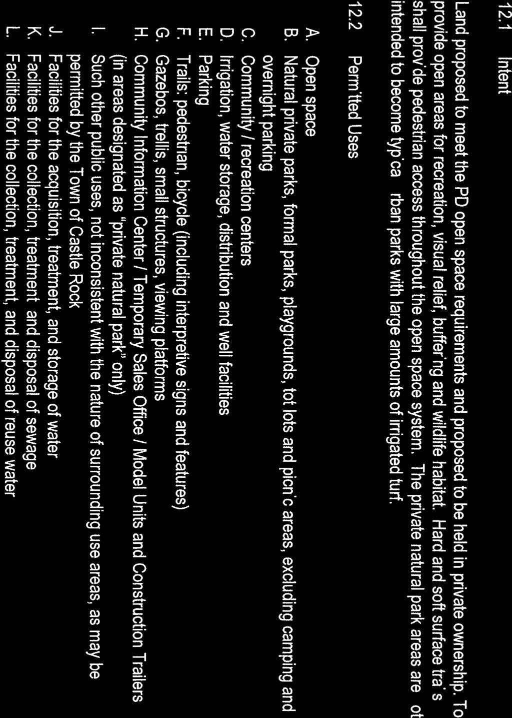

47
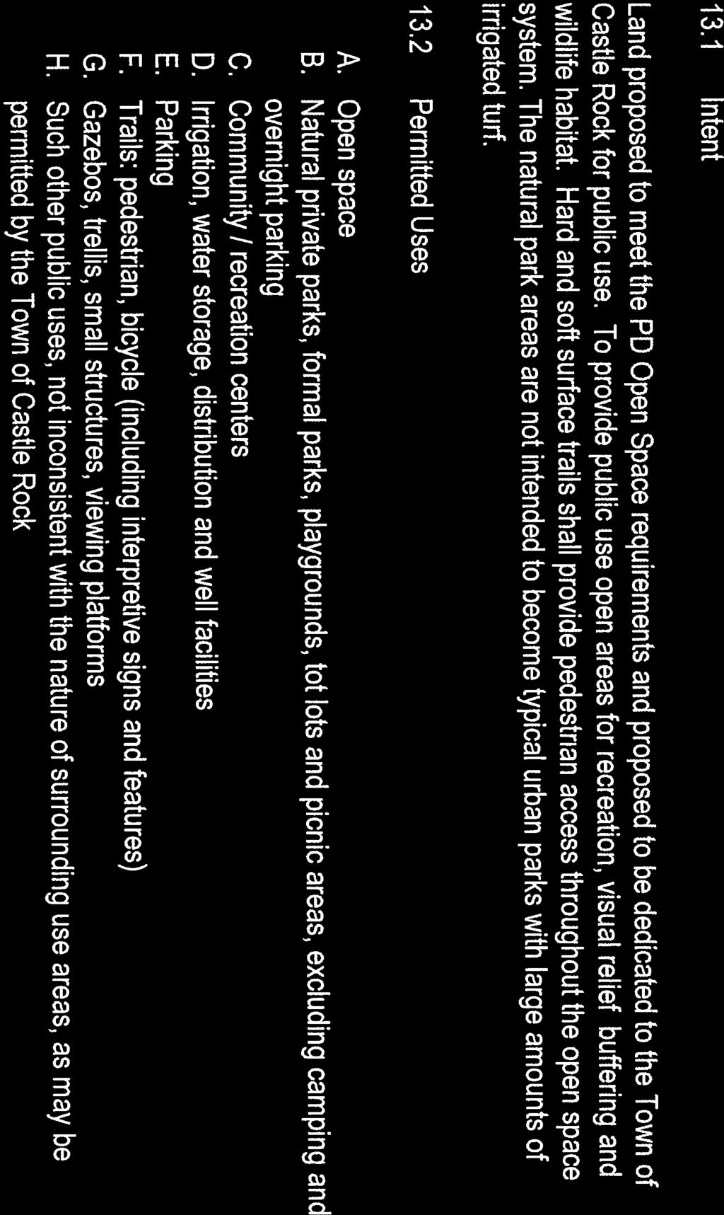

48
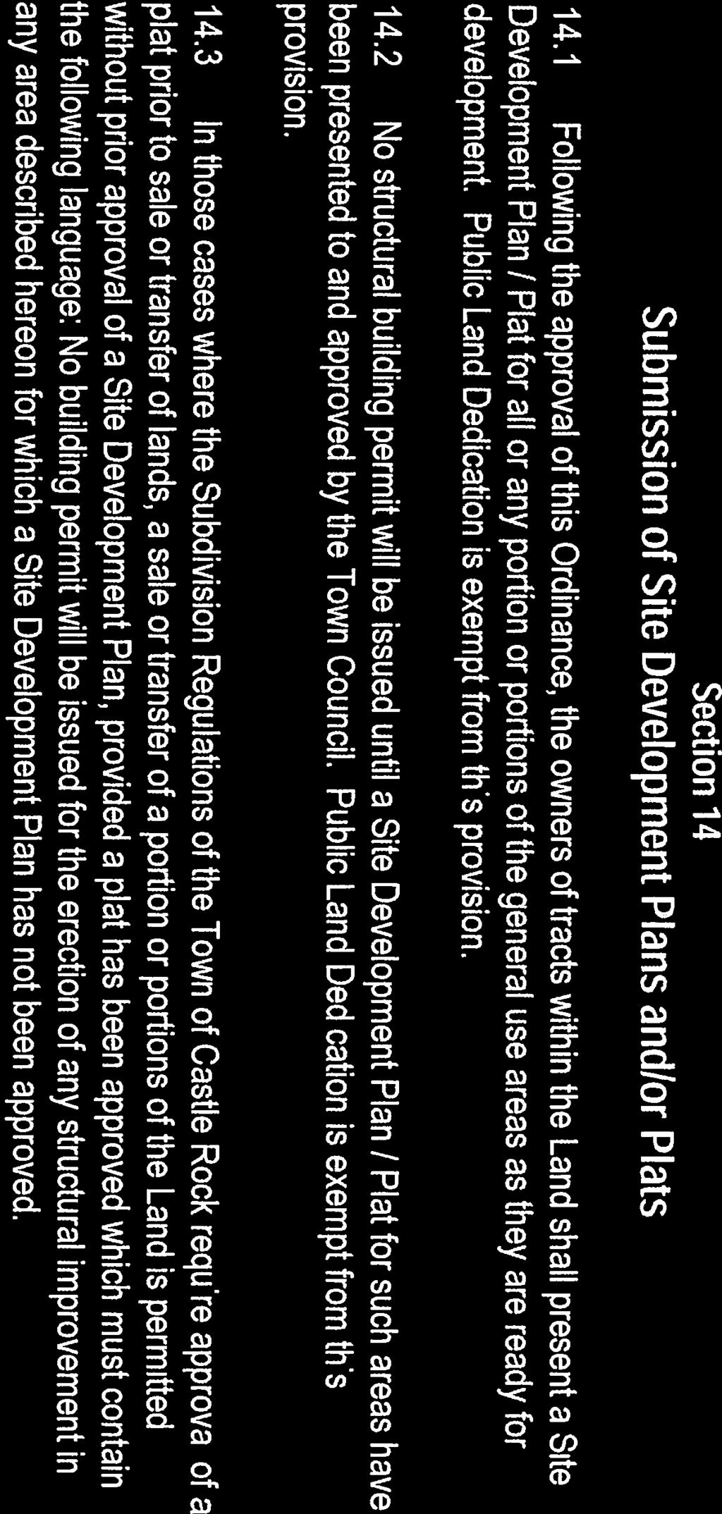
49
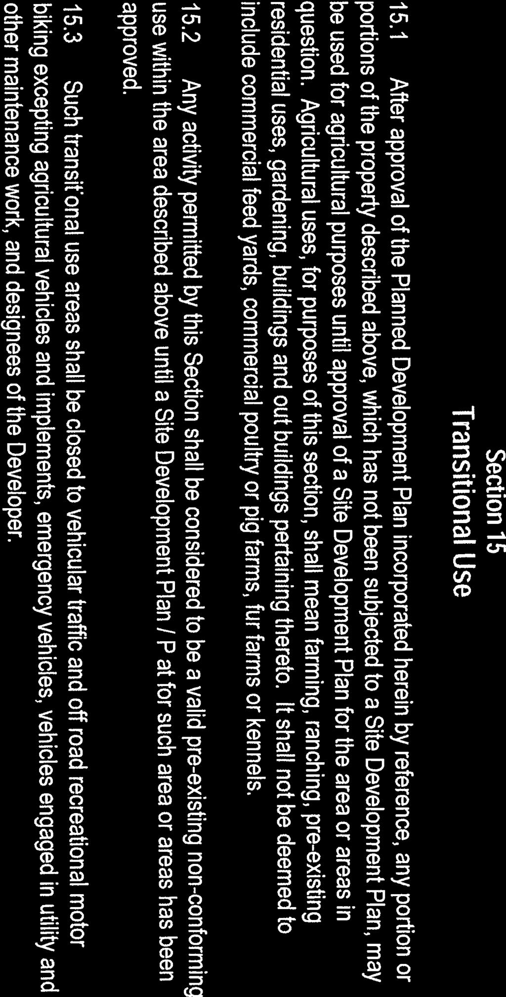
50


51


52
53


54


55


56

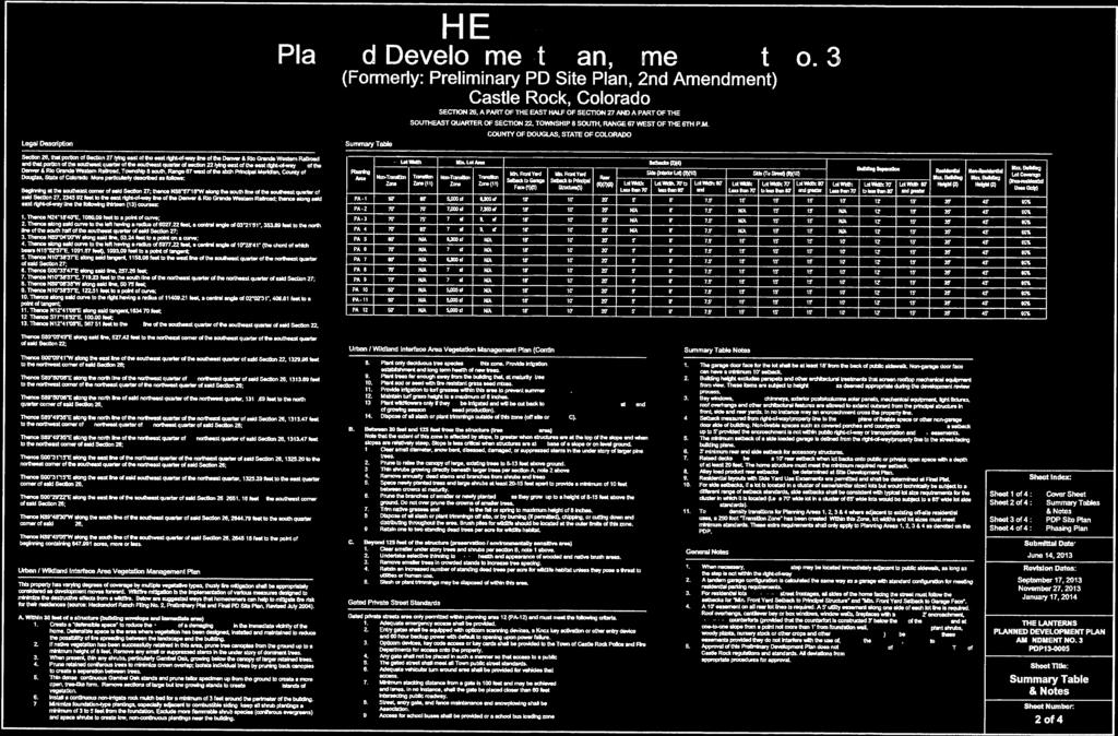
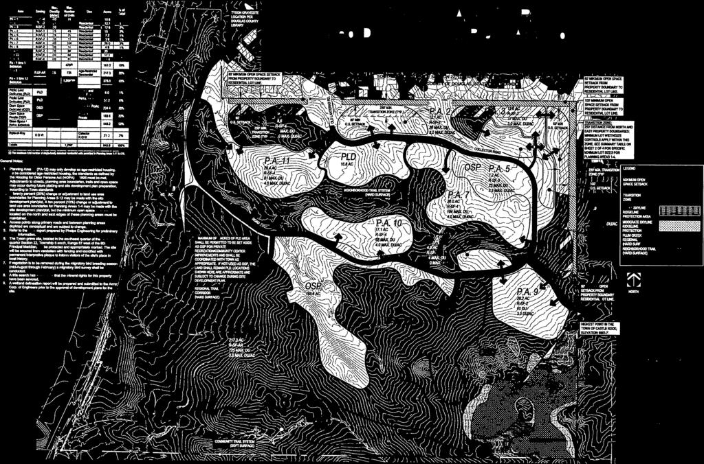
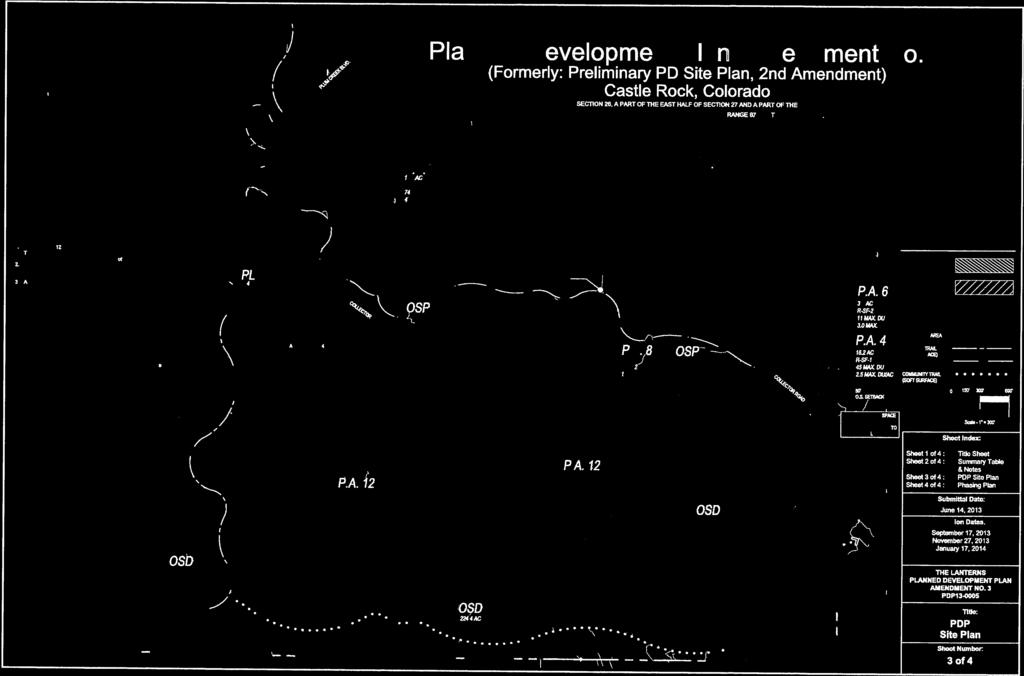
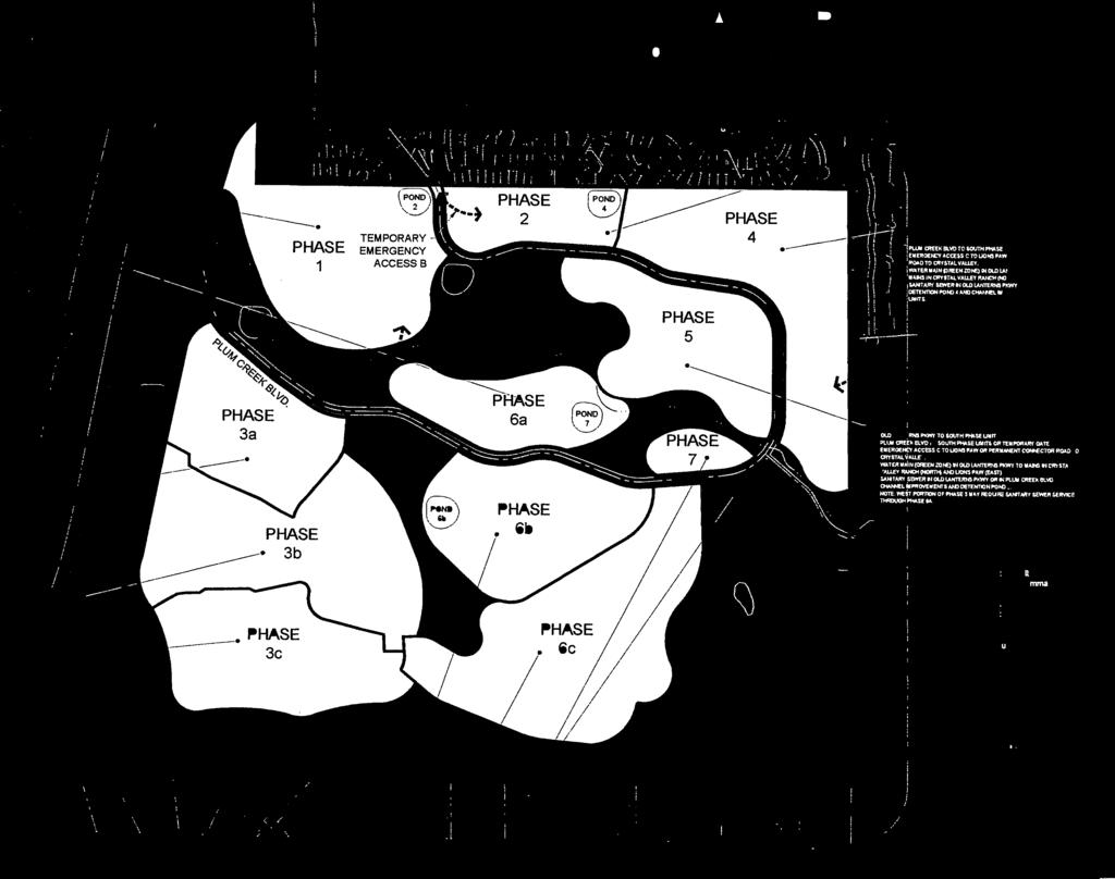
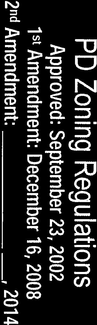
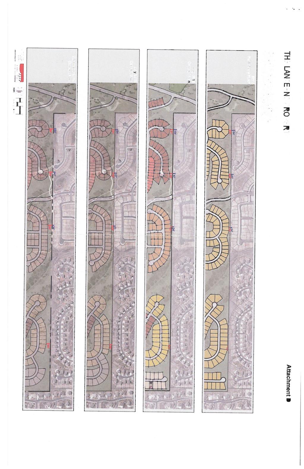
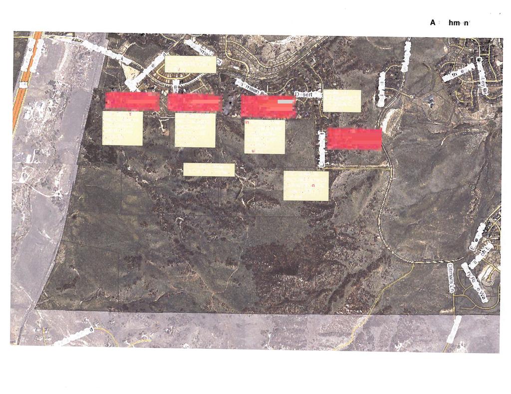
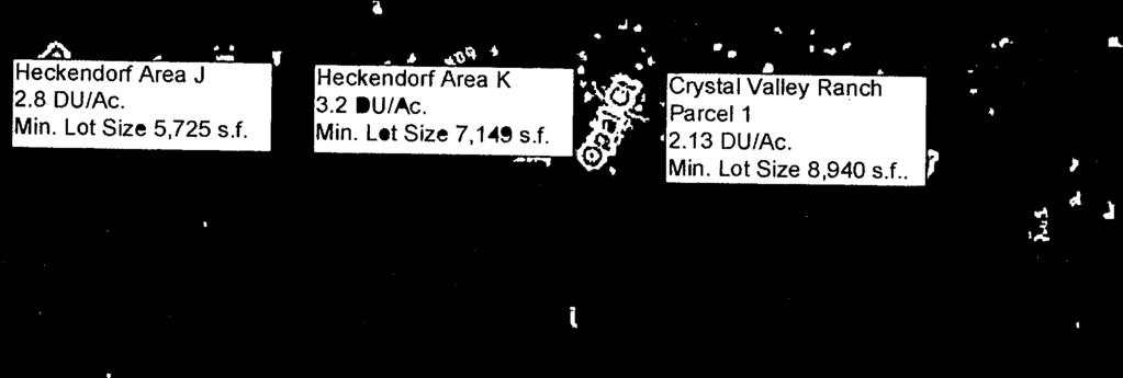
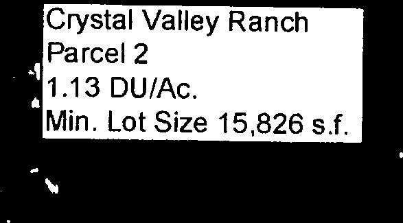
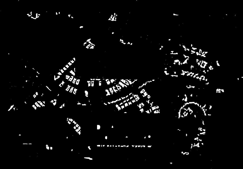
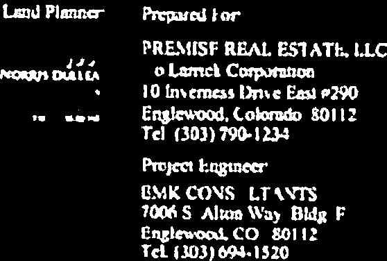
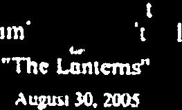
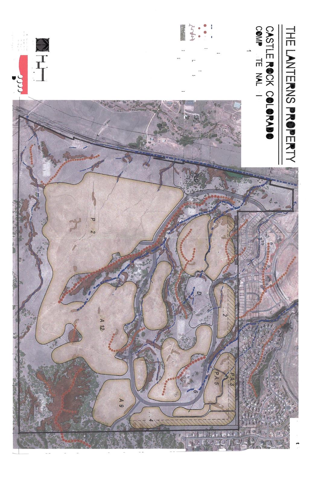
57 Item # Meeting Date: February 27, 2014 AGENDA MEMORANDUM To: From: Planning Commission Sandy Vossler, Planner II, Development Services Department Date: February 26, 2014 Title: The Lanterns Planned Development Plan Revised Phasing Plan Executive Summary Recent revisions were made to the proposed Lanterns Planned Development Plan Phasing Plan. Please replace sheet 4 of 4 of the Planned Development Plan that was included in your packet with the revised Phasing Plan attached to this memorandum (Attachment A). The revisions include labeling of the Public Land Dedication (PLD) and the public and private open space (OSD and OSP, respectively). New General Notes have been added to more specifically define phased road improvements, temporary emergency accesses, the necessary improvements to serve phases developed out of sequence. In addition, the lists of improvements and dedications listed under each phase label have been expanded to address internal street system improvements by phase. Finally, staff received a letter dated February 2, 2014 from Gary and Laura Hamilton objecting to the proposed rezoning of The Lanterns Planned Devlopment. A copy of the letter is attached (Attachment B). Thank you. Attachments Attachment A: The Lanterns Planned Development Plan Phasing Plan Sheet 4 of 4 Attachment B: Hamilton Letter dated February 2, 2014 T:\Development Review\Lanterns\Lanterns Rezone 2013\Public Hearings\Planning Commission\PC Staff Report and Attachments\Revised Phasing Plan 1
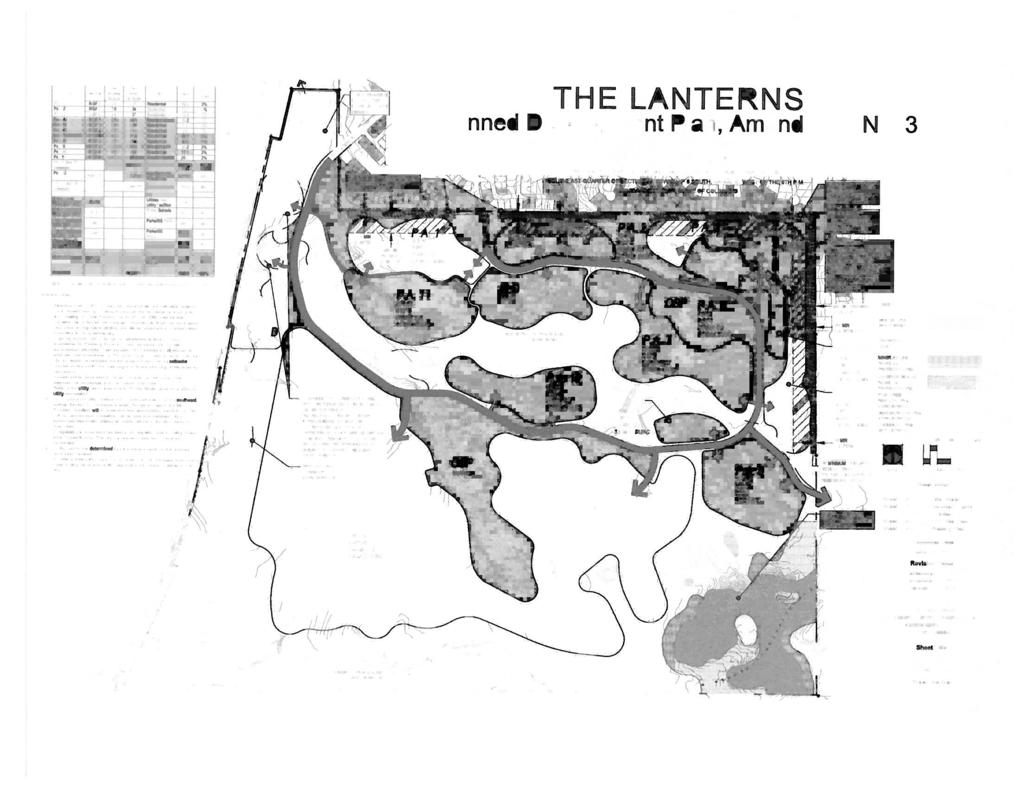
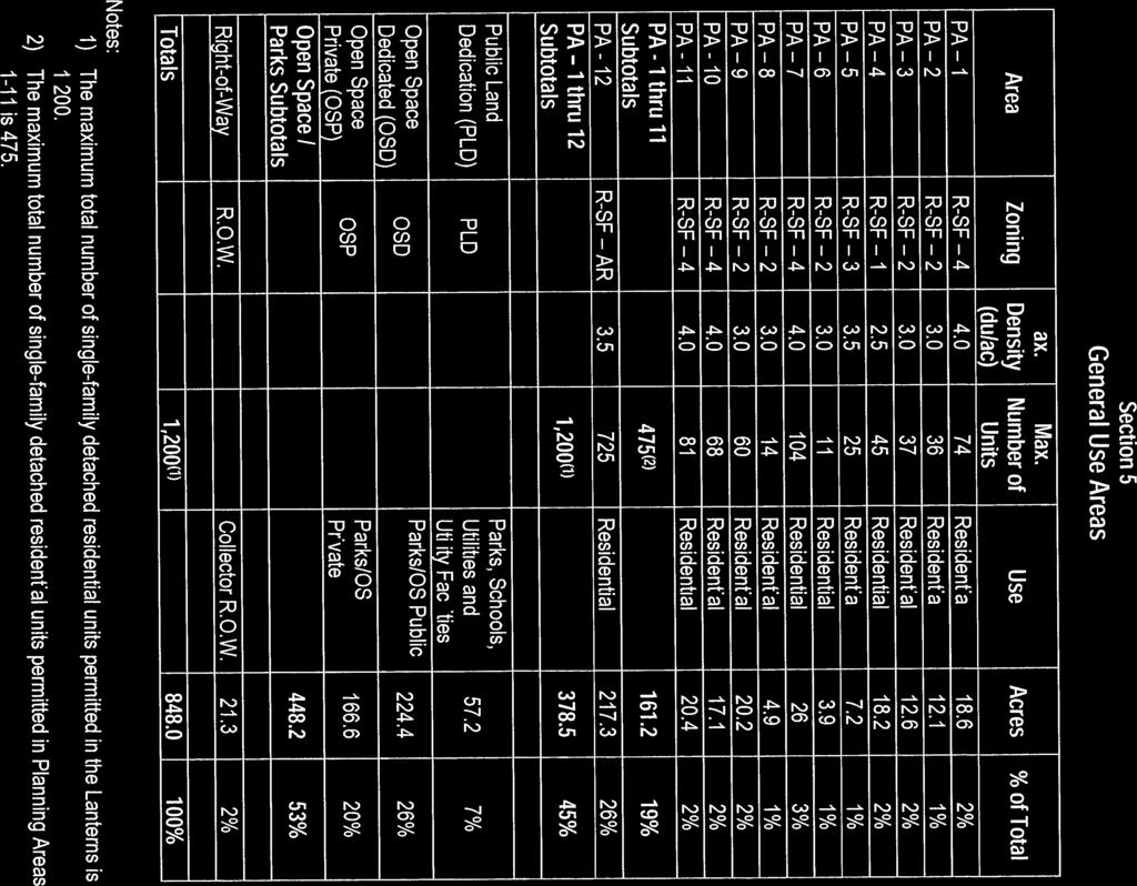
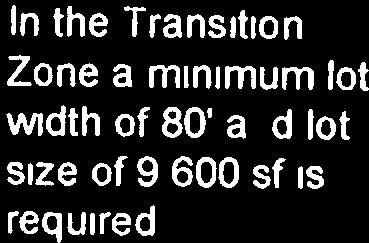
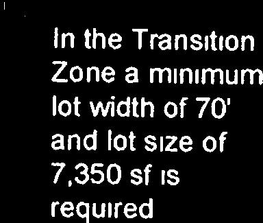
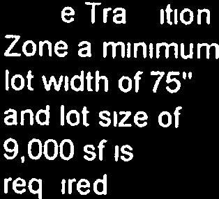
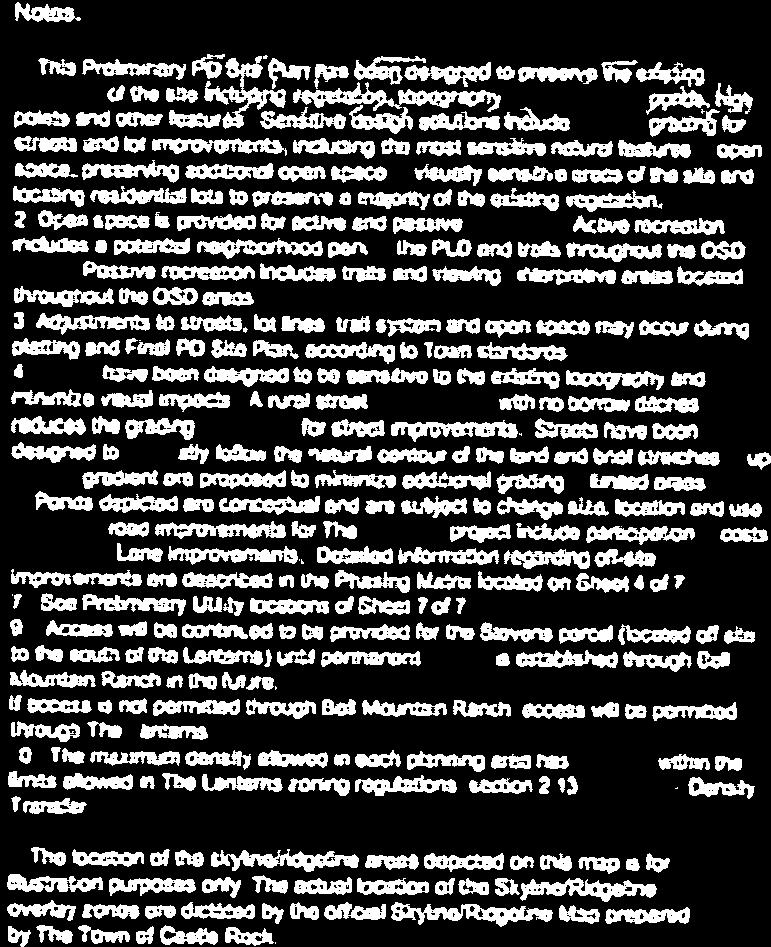
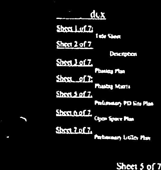
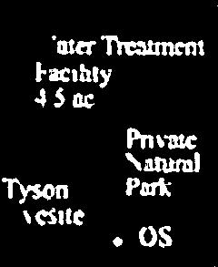
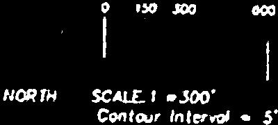
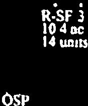
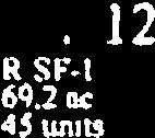
58 GENERAL NOTES PHASES MAY BE DEVELOPED IN ANY SEQUENCE OR CONCURRENTLY PROVIDED THAT ALL IMPROVEMENTS ASSIGNED TO OTHER PHASES WHICH ARE NECESSARY TO SERVE THE PHASE(S) WITHIN WHICH DEVELOPMENT IS COMMENCING HAVE EITHER BEEN PREVIOUSLY CONSTRUCTED AND ACCEPTED PER TOWN CRITERIA, OR WILL BE CONSTRUCTED BY THE DEVELOPER OF THE PHASES(S) UNDERGOING DEVELOPMENT. IMPROVEMENTS INCLUDE, BUT NOT LIMITED TO, THE FULL CROSS SECTIONS OF PLUM CREEK BLVD AND OLD LANTERNS PKWY WITH CURB, GUTTER, SIDWEWALKS, TURN LANES, STREET LIGHTING, WATER, SANITARY SEWER, PARKS, TRAILS AND INTERNAL, ADJACENT AND DOWNSTREAM DRAINAGE CHANNEL IMPROVEMENTS AND STORMWATER MANAGEMENT FACILITIES. DEVELOPMENT OF SUB-PHASES WITHIN EACH PHASE MAY BE DETERMINED AT TIME OF CONSTRUCTION DOCUMENTS. TURNAROUND AREAS PER TOWN CRITERIA SHALL BE PROVIDED WHEN PLUM CREEK BLVD OR OLD LANTERNS PARKWAY TERMINATE AT A PHASE LINE OR INTERIM TERMINUS. WHEN PHASE 7 IS DEVELOPED, THE COMPLETE LOOPED ROADS OF PLUM CREEK BLVD AND OLD LANTERNS PKWY SHALL BE CONSTRUCTED. IN ALL CASES, THE FULL CROSS SECTION OF PLIM CREEK BLVD AND OLD LANTERNS PKWY SHALL BE CONSTRUCTED ALONG THE ENTIRE FRONTAGE OF THE PHASE BEING DEVELOPED AND SHALL BE CONNECTED TO PREVIOUSLY CONSTRUCTED SECTIONS OF THOSE STREETS. WHERE THE PERMANENT CONNECTOR ROAD TO CRYSTAL VALLEY IS NECESSARY FOR ACCESS PURPOSES, IT IS UNDERSTOOD THAT A CRYSTAL VALLEY PUBLIC STREET FROM THE PERMANENT CONNECTOR ROAD TO LOOP ROAD MUST BE AVAILABLE FOR USE. IF THE PERMANENT COLLECTOR ROAD IS IN PLACE TO CRYSTAL VALLEY, THE TEMPORARY EMERGENCY ACCESS C TO LION'S PAW WILL NOT BE CONSTRUCTED. IT IS THE DEVELOPER'S RESPONSIBILITY TO ACQUIRE OFF-SITE EASEMENTS AS NEEDED FOR SECONDARY ACCESS. THE DEVELOPER IS RESPONSIBLE FOR MAINTAINING ALL TEMPORARY EMERGENCY VEHICLE ACCESSES, ROUTES AND GATES, INCLUDING SNOW REMOVAL. TEMPORARY EMERGENCY VEHICLE ACCESS ROUTES ARE CONCEPTUAL ONLY. THE FIRE DEPARTMENT SHALL REVIEW ALL ELEMENTS OF THE EMERGENCY VEHICLE ACCESS ROUTES DURING SITE PLANNING STAGE. ALL PUBLIC LAND DEDICATIONS SHALL BE MADE AT THE TIME OF THE FIRST PLAT, REGARDLESS OF THE PHASE SEQUENCE. AMENDMENTS TO THIS PHASING PLAN MAY BE APPROVED ADMINISTRATIVELY AS DETERMINED BY THE DEVELOPMENT SERVICES DIRECTOR. PHASE 1 PLUM CREEK BLVD TO WEST PHASE ENTRANCE. OLD LANTERNS PKWY TO EAST PHASE ENTRANCE. WATER MAIN (RED ZONE) IN PLUM CREEK BLVD TO WEST PHASE ENTRANCE. WATER MAIN (RED ZONE) IN OLD LANTERNS PKWY TO EAST PHASE ENTRANCE. SANITARY SEWER ALONG WEST PROPERTY LINE TO WEST PHASE LIMITS. CHANNEL IMPROVEMENTS AND DETENTION POND 1 WEST OF PLUM CREEK BLVD. TYSON GRAVE SITE IMPROVEMENTS COMPLETE INTERNAL STREET SYSTEM WITHIN PHASE 1 OR SUBPHASE AS SHOWN ON THE CONSTRUCTION DOCUMENTS. PHASE 6A PLUM CREEK BLVD TO TEMPORARY EMERGENCY ACCESS C TO LIONS PAW OR PERMANENT CONNECTOR ROAD TO CRYSTAL VALLEY. WATER MAIN IN (GREEN ZONE) PLUM CREEK BLVD AND OLD LANTERNS PKWY TO MAINS IN CRYSTAL VALLEY RANCH (NORTH) AND LIONS PAW (EAST). SANITARY SEWER IN PLUM CREEK BLVD TO SEWER ALONG WEST PROPERTY LINE. CHANNEL IMPROVEMENTS FROM PLUM CREEK BLVD CROSSING AND DETENTION POND 6A. CHANNEL IMPROVEMENTS FROM DETENTION POND 6a TO WEST PROPERTY OUTFALL. TRAIL ALONG SOUTH PROPERTY LINE. TRAIL ALONG CENTRAL OPEN SPACE CORRIDOR. COMPLETE INTERNAL STREET SYSTEM WITHIN PHASE 6A OR SUBPHASE AS SHOWN ON THE CONSTRUCTION DOCUMENTS. PHASE 3A PLUM CREEK BLVD TO EAST PHASE LIMITS. TEMPORARY EMERGENCY ACCESS B TO PHASE 1 OR OLD LANTERNS PKWY. WATER MAIN (RED ZONE) IN PLUM CREEK BLVD TO EAST PHASE LIMITS. WATER MAIN (RED ZONE) IN TEMPORARY ACCESS B CONNECTING TO OLD LANTERNS PKWY MAIN OR PHASE 1 MAIN. SANITARY SEWER ALONG WEST PROPERTY LINE TO WEST PHASE LIMITS. REGIONAL TRAIL ALONG WEST PROPERTY LINE TO SOUTHWEST PHASE LIMITS. CHANNEL IMPROVEMENTS AND DETENTION POND 3a. COMPLETE INTERNAL STREET SYSTEM WITHIN PHASE 3A OR SUBPHASE AS SHOWN ON THE CONSTRUCTION DOCUMENTS. PHASE 3B DEVELOPED CONCURRENTLY WITH PHASE 3A OR WHEN PHASE 3A COMPLETE. CONNECT ALL IMPROVEMENTS TO EXISTING PHASE 3A IMPROVEMENTS. REGIONAL TRAIL ALONG WEST PROPERTY LINE TO SOUTHWEST PHASE LIMITS. COMPLETE INTERNAL STREET SYSTEM WITHIN PHASE 3B OR SUBPHASE AS SHOWN ON THE CONSTRUCTION DOCUMENTS. PHASE 3C DEVELOPED CONCURRENTLY WITH PHASES 3A AND 3B OR WHEN PHASES 3A AND 3B COMPLETE. CONNECT ALL IMPROVEMENTS TO EXISTING PHASE 3A AND 3B IMPROVEMENTS. REGIONAL TRAIL ALONG WEST PROPERTY LINE TO SOUTHWEST PHASE LIMITS. COMPLETE INTERNAL STREET SYSTEM WITHIN PHASE 3C OR SUBPHASE AS SHOWN ON THE CONSTRUCTION DOCUMENTS. CONCEPTUAL PHASE ACCESS POINT PHASE 6B OSD PLD POND 3a POND 1 POND 6a PLUM CREEK BLVD. PHASE 3a PLUM CREEK BLVD TO TEMPORARY GATED EMERGENCY ACCESS C TO LIONS PAW OR PERMANENT CONNECTOR ROAD TO CRYSTAL VALLEY. WATER MAIN (GREEN ZONE) IN PLUM CREEK BLVD AND OLD LANTERNS BLVD TO MAINS IN CRYSTAL VALLEY RANCH (NORTH) AND LIONS PAW (EAST). SANITARY SEWER IN PLUM CREEK BLVD TO SEWER ALONG WEST PROPERTY LINE. COMPLETE INTERNAL STREET SYSTEM WITHIN PHASE 6B OR SUBPHASE AS SHOWN ON THE CONSTRUCTION DOCUMENTS. PHASE 6C OSP SANITARY SEWER CONNECTION SANITARY SEWER CONNECTION RED ZONE WATER CONNECTION PHASE 3b PHASE 3c PHASE 1 TEMPORARY EMERGENCY ACCESS A POND 2 TEMPORARY EMERGENCY ACCESS A OSP OSD POND 6b DEVELOPED CONCURRENTLY WITH PHASE 6B OR WHEN PHASE 6B COMPLETE. CONNECT ALL IMPROVEMENTS TO EXISTING PHASE 6B IMPROVEMENTS. NOTE: A PORTION OF PHASE 6B MAY REQUIRE SANITARY SEWER THROUGH PHASE 3C. COMPLETE INTERNAL STREET SYSTEM WITHIN PHASE 6C OR SUBPHASE AS SHOWN ON THE CONSTRUCTION DOCUMENTS. Planned Development Plan, Amendment No. 3 (Formerly: Preliminary PD Site Plan, 2nd Amendment) Castle Rock, Colorado SECTION 26, A PART OF THE EAST HALF OF SECTION 27 AND A PART OF THE POND 5 PLD RED ZONE WATER CONNECTION PHASE 2 OLD LANTERNS PKWY. PHASE 6a PHASE 6b PHASE 7 POND 7 PHASE 6c SOUTHEAST QUARTER OF SECTION 22, TOWNSHIP 8 SOUTH, RANGE 67 WEST OF THE 6TH P.M. POND 4 GREEN ZONE WATER CONNECTION OSP COUNTY OF DOUGLAS, STATE OF COLORADO PHASE 5 PHASE 7 OSD PHASE 4 PHASE 7 PHASE 2 OLD LANTERNS PKWY TO EAST LIMITS OF PHASE. TEMPORARY EMERGENCY ACCESS A TO OLD LANTERNS PKWY. WATER MAIN (RED ZONE) IN OLD LANTERNS PKWY TO EAST END OF PHASE LOOPING TO EXISTING MAIN IN CRYSTAL VALLEY RANCH. SANITARY SEWER IN OLD LANTERNS PKWY TO EAST PHASE LIMITS TO SEWER IN HECKENDORF RANCH OR PHASE 1 SEWER. DETENTION POND 2 AND CHANNEL IMPROVEMENTS ADJACENT TO OLD LANTERNS PKWY AT NORTH PROPERTY LINE. COMPLETE INTERNAL STREET SYSTEM WITHIN PHASE 2 OR SUBPHASE AS SHOWN ON THE CONSTRUCTION DOCUMENTS. PHASE 4 OLD LANTERNS PKWY TO SOUTH PHASE LIMITS. PLUM CREEK BLVD TO SOUTH PHASE LIMITS OR TEMPORARY GATED EMERGENCY ACCESS C TO LIONS PAW OR PERMANENT CONNECTOR ROAD TO CRYSTAL VALLEY. WATER MAIN (GREEN ZONE) IN OLD LANTERNS PKWY CONNECTING TO MAINS IN CRYSTAL VALLEY RANCH (NORTH) AND LIONS PAW (EAST). SANITARY SEWER IN OLD LANTERNS PKWY OR IN PLUM CREEK BLVD. DETENTION POND 4 AND CHANNEL IMPROVEMENTS AT WEST PHASE LIMITS. COMPLETE INTERNAL STREET SYSTEM WITHIN PHASE 4 OR SUBPHASE AS SHOWN ON THE CONSTRUCTION DOCUMENTS. TEMPORARY GATED EMERGENCY ACCESS C (TO BE REMOVED UPON COMPLETION OF MAIN ROAD LOOP OR CONNECTOR ROAD TO CRYSTAL VALLEY) PHASE 5 PLUM CREEK BLVD TO TEMPORARY GATED EMERGENCY ACCESS C TO LIONS PAW OR PERMANENT CONNECTOR ROAD TO CRYSTAL VALLEY. WATER MAIN (GREEN ZONE) IN PLUM CREEK BLVD AND OLD LANTERNS PKWY TO MAINS IN CRYSTAL VALLEY RANCH (NORTH) AND LIONS PAW (EAST). SANITARY SEWER IN PLUM CREEK BLVD TO SEWER ALONG WEST PROPERTY LINE. CHANNEL IMPROVEMENTS AND DETENTION POND 7. TRAIL ADJACENT TO PHASE 7. COLLECTOR ROAD TO CRYSTAL VALLEY SHALL BE BUILT TO LANTERNS PROPERTY BOUNDARY. COMPLETE INTERNAL STREET SYSTEM WITHIN PHASE 7 OR SUBPHASE AS SHOWN ON THE CONSTRUCTION DOCUMENTS. GREEN ZONE WATER CONNECTION OLD LANTERNS PKWY TO SOUTH PHASE LIMITS. PLUM CREEK BLVD TO SOUTH PHASE LIMITS OR TEMPORARY GATED EMERGENCY ACCESS C TO LIONS PAW OR PERMANENT CONNECTOR ROAD TO CRYSTAL VALLEY. WATER MAIN (GREEN ZONE) IN OLD LANTERNS PKWY TO MAINS IN CRYSTAL VALLEY RANCH (NORTH) AND LIONS PAW (EAST). SANITARY SEWER IN OLD LANTERNS PKWY OR IN PLUM CREEK BLVD. CHANNEL IMPROVEMENTS AND DETENTION POND 5. NOTE: WEST PORTION OF PHASE 5 MAY REQUIRE SANITARY SEWER SERVICE THROUGH PHASE 6A. COMPLETE INTERNAL STREET SYSTEM WITHIN PHASE 5 OR SUBPHASE AS SHOWN ON THE CONSTRUCTION DOCUMENTS. CONNECTOR ROAD TO CRYSTAL VALLEY Sheet 1 of 4 : Sheet 2 of 4 : Sheet 3 of 4 : Sheet 4 of 4 : Sheet Index: Title Sheet Summary Table & Notes PDP Site Plan Phasing Plan Submittal Date: June 14, 2013 Revision Dates : September 17, 2013 November 27, 2013 January 17, 2014 THE LANTERNS PLANNED DEVELOPMENT PLAN AMENDMENT NO. 3 PDP Sheet Title: PHASING PLAN Sheet Number : 4 OF 4

59
Drexel, Barrell & Co.
 Drexel, Barrell & Co. June 18, 2018 Engineers/Surveyors Boulder Colorado Springs Greeley 3 South 7 th Street Colorado Springs, Colorado 80905-1501 719 260-0887 719 260-8352 Fax El Paso County Planning
MASTER DEVELOPMENT DRAINAGE PLAN FOR MONUMENT HEIGHTS
 MASTER DEVELOPMENT DRAINAGE PLAN FOR MONUMENT HEIGHTS DRAINAGE REPORT STATEMENT ENGINEER'S STATEMENT: The attached drainage plan and report were prepared under my direction and supervision and are correct
CHECKLIST FOR PHASE II DRAINAGE REPORT
 I. COVER SHEET CHECKLIST FOR PHASE II DRAINAGE REPORT A. Name of Project B. Address C. Owner D. Developer E. Engineer F. Submittal date and revision dates as applicable II. GENERAL LOCATION AND DESCRIPTION
CITY COUNCIL STUDY SESSION MEMORANDUM
 City and County of Broomfield, Colorado CITY COUNCIL STUDY SESSION MEMORANDUM To: From: Prepared by: Mayor and City Council Charles Ozaki, City and County Manager Kevin Standbridge, Deputy City and County
Drexel, Barrell & Co.
 Drexel, Barrell & Co. December 21, 2018 Engineers/Surveyors Boulder Colorado Springs Greeley 3 South 7 th Street Colorado Springs, Colorado 80905-1501 719 260-0887 719 260-8352 Fax El Paso County Planning
13. PRELIMINARY PLAT NO MILLS FARM - Vicinity of the southeast corner of 159 th Street and Quivira Road
 13. corner of 159 th Street and Quivira Road 1. APPLICANT: HNTB Corporation is the applicant for this request. 2. REQUESTED ACTION: The applicant is requesting approval of a preliminary plat for a 383-lot
Re: Thorncreek Commons Commercial Response to Pre-Application Meeting held September 24, 2014 Comments
 8/20/2015 Jay Ruchti Senior Planner City Development Department City of Thornton 9500 Civic Center Drive Thornton, CO Re: Thorncreek Commons Commercial Response to Pre-Application Meeting held September
Development. Within of 25% or greater. ridges anticipated that the. foundations. and walk out. Page 1 of 4
 Ridge Estates May 11, 2016 LAND SUITABILITY ANALYSIS REPORT 1. INTRODUCTION This report is provided in accordance with the submittal requirements of the Planned Development Plan (PPD). The report accompanies
CITY PLANNING COMMISSION AGENDA ITEM: C STAFF: ROBERT TEGLER FILE NO: CPC PUD QUASI-JUDICIAL
 CPC AGENDA June 8, 2006 Page 37 CITY PLANNING COMMISSION AGENDA ITEM: C STAFF: ROBERT TEGLER FILE NO: CPC PUD 05-294 - QUASI-JUDICIAL PROJECT: APPLICANT: OWNER: PARKWOOD AT WOLF RANCH NASS DESIGN ASSOCIATES
MOBILE CITY PLANNING COMMISSION LETTER OF DECISION. October 22, 2010
 MOBILE CITY PLANNING COMMISSION LETTER OF DECISION Archbishop of Mobile 400 Government St. Mobile, AL 36602 Re: Case #SUB2010-00075 (Subdivision) 3650 Springhill Avenue (Northwest corner of Springhill
Development. Within of 25% or greater. ridges anticipated that the. foundations. and walk out. Page 1 of 4
 Ridge Estates May 11, 2016 LAND SUITABILITY ANALYSIS REPORT 1. INTRODUCTION This report is provided in accordance with the submittal requirements of the Planned Development Plan (PPD). The report accompanies
CITY OF VACAVILLE PLANNING COMMISSION Agenda Item No. G.1 STAFF REPORT February 21, 2012 BRIGHTON LANDING SPECIFIC PLAN & DEVELOPMENT PROJECT
 CITY OF VACAVILLE PLANNING COMMISSION Agenda Item No. G.1 STAFF REPORT February 21, 2012 Staff Contact: Fred Buderi (707) 449-5307 TITLE: PURPOSE: BRIGHTON LANDING SPECIFIC PLAN & DEVELOPMENT PROJECT INFORMATIONAL
SEMSWA s Role in the Land Development Process
 SEMSWA s Role in the Land Development Process One of SEMSWA s responsibilities is to ensure that any new development or redevelopment within its service area is designed and constructed in compliance with
Town of Castle Rock DRCOG 2013 Annual Growth and Development Report. Introduction. Section 1 Metro Vision 2035
 Town of Castle Rock DRCOG 2013 Annual Growth and Development Report Introduction This is the Town of Castle Rock s sixth annual report to the Denver Regional Council of Governments (DRCOG) reporting on
PLANNED UNIT DEVELOPMENT & SUBDIVISION STAFF REPORT Date: May 18, 2017
 & PUD-0000102-2017 PLANNED UNIT DEVELOPMENT & SUBDIVISION STAFF REPORT Date: May 18, 2017 NAME SUBDIVISION NAME Dauphin Creek Estates Subdivision Dauphin Creek Estates Subdivision LOCATION CITY COUNCIL
SPECIAL COMMITTEE OF THE WHOLE DECEMBER 9, 2002 BLOCK 57/58 WEST BLOCK PLAN BLOCK PLAN FILE BL.57/58W.99 HUNTINGTON BUSINESS PARK LAND OWNERS
 SPECIAL COMMITTEE OF THE WHOLE DECEMBER 9, 2002 BLOCK 57/58 WEST BLOCK PLAN BLOCK PLAN FILE BL.57/58W.99 HUNTINGTON BUSINESS PARK LAND OWNERS Recommendation The Commissioner of Planning recommends: THAT
REQUEST FOR COUNCIL ACTION 6A AGENDA ITEM ORIGINATING DEPT. AGENDA ITEM CITY ADMINISTRATOR APPROVAL
 DATE REQUEST FOR COUNCIL ACTION 6A AGENDA ITEM ORIGINATING DEPT. AGENDA ITEM CITY ADMINISTRATOR APPROVAL Community Development Territorial Greens PUD Concept Plan Development Stage Plan Subdivision (Preliminary
Planning Commission Staff Report Project Plan Approval Hearing Date: June 14, 2017
 Planning Commission Staff Report Project Plan Approval Hearing Date: June 14, 2017 ITEM 3 Peter Matson requests Project Plan Approval for an 80-acre mixed-use plan that includes 220 residential units and
EXHIBIT B PROJECT NARRATIVE POULSBO MEADOWS
 EXHIBIT B PROJECT NARRATIVE POULSBO MEADOWS Name of Project: Poulsbo Meadows; A Planned Residential Development (PRD)/Plat Applicants Name: PBH Group LLC/Byron Harris PO Box 1010 Silverdale, WA 98038 Description
THE CITY OF MOBILE, ALABAMA
 THE CITY OF MOBILE, ALABAMA LETTER OF DECISION Ark of Safety, Inc. Mobile, AL 36617 Re: (Northwest corner of Main Street and First Avenue, extending to the Southwest corner of Esau Avenue and Main Street.)
Bylaw C-1262 Adopted February 6, Planning and Development Department
 Bylaw C-1262 Adopted February 6, 2012 Planning and Development Department CITY OF GRANDE PRAIRIE BYLAW C-1262 A Bylaw to adopt the Brookfield Neighbourhood Outline Plan THE MUNICIPAL COUNCIL OF THE CITY
City of Fort Lupton Administrative Site Plan Process
 City of Fort Lupton Administrative Site Plan Process Purpose The Site Plan process is meant to promote orderly and sound development standards as they apply to the City. These site development standards
Application Number: SD Project Name: Walton Farms Preliminary Subdivision (acting as Master Plan)
") STAFF REPORT Town of Clayton Planning Department 111 E. Second Street, Clayton, NC 27520 P.O. Box 879, Clayton, NC 27528 Phone: 919-553-5002 Fax: 919-553-1720 Planning Board May 22, 2017 Application Number:
STAFF REPORT Town of Clayton Planning Department 111 E. Second Street, Clayton, NC 27520 P.O. Box 879, Clayton, NC 27528 Phone: 919-553-5002 Fax: 919-553-1720 Planning Board May 22, 2017 Application Number:
Carolina North Individual Permit Application September 2010 Draft
 Carolina North Individual Permit Application September 2010 Draft Appendix C Jurisdictional Streams, Wetlands, and Buffer Impacts Figures (C- 1 through C-17) C-1 Sheet Index: Impacts within and Outside
FORMER CANADIAN FORCES BASE (CFB) ROCKCLIFFE SECONDARY PLAN. Official Plan Amendment XX to the Official Plan for the City of Ottawa
 ROCKCLIFFE SECONDARY PLAN. Official Plan Amendment XX to the Official Plan for the City of Ottawa") FORMER CANADIAN FORCES BASE (CFB) ROCKCLIFFE SECONDARY PLAN Official Plan Amendment XX to the Official Plan for the City of Ottawa 1 INDEX THE STATEMENT OF COMPONENTS PART A THE PREAMBLE PAGE Purpose...
FORMER CANADIAN FORCES BASE (CFB) ROCKCLIFFE SECONDARY PLAN Official Plan Amendment XX to the Official Plan for the City of Ottawa 1 INDEX THE STATEMENT OF COMPONENTS PART A THE PREAMBLE PAGE Purpose...
PLANNED UNIT DEVELOPMENT Date: April 5, 2018
 PLANNED UNIT DEVELOPMENT Date: April 5, 2018 DEVELOPMENT NAME SUBDIVISION NAME LOCATION Robert Myers Robert Myers 2955 and 2989 Dauphin Street (Southeast corner of Dauphin Street and Sage Avenue) CITY
Sheet Index. Legal Description. General Notes: Vicinity Map Scale 1" = 600'
 LOCATED IN THE SOHWEST QUARTER OF SECTION, TOWNSHIP SOH, Case # Z 6 - Legal Description Tract G, H and J of the Villages at Riverdale Filing No., a part of the Southwest quarter of Section, Township South,
Request for Decision. Recommendation. Presented: Monday, Jul 07, Report Date Friday, Jun 20, Type: Public Hearings
 Presented To: Planning Committee Request for Decision Application for rezoning in order to permit a place of worship on a vacant lot zoned for C1, Local Commercial uses, Cam Street, Sudbury Sitiri Investments
Project phasing plan (if applicable) 12 copies of site plan
 12 copies of site plan") SITE PLAN REVIEW PERMIT APPLICATION City of Grand Haven, 11 N. Sixth Street, Grand Haven, MI 49417 Phone: (616) 847-3490 Fax: (616) 844-2051 Website: www.grandhaven.org 1. Project Information Address/location
SITE PLAN REVIEW PERMIT APPLICATION City of Grand Haven, 11 N. Sixth Street, Grand Haven, MI 49417 Phone: (616) 847-3490 Fax: (616) 844-2051 Website: www.grandhaven.org 1. Project Information Address/location
USA Addition of South & East Side Residential Parcels. USA Deletion of a Town of Christiana Parcel. Conversion from USA to Limited Service Area
 Village of Rockdale Village of Rockdale 148 Water Street Cambridge, WI 53523 Phone 608.423.1497 Fax 608.423.9694 Urban Service Area (USA) Amendment USA Addition of South & East Side Residential Parcels
C ity of Grande Prairie Development Services Department
 C ity of Grande Prairie Development Services Department FAIRWAY DEVELOPMENT OUTLINE PLAN OP 08 09 Approved April 6, 2009 Prepared by: Focus Corporation Table of Contents 1.0. Introduction 2 3 1.1. Plan
SUBMITTAL REQUIREMENTS: FINAL PLAN REVIEW- PROJECT DEVELOPMENT PLAN (PDP)
") 1) Application form and filing fee. Application Form.pdf Development Review Guide STEP 6 of 8 SUBMITTAL REQUIREMENTS: FINAL PLAN REVIEW- PROJECT DEVELOPMENT PLAN (PDP) 2) Transportation Development Review
1) Application form and filing fee. Application Form.pdf Development Review Guide STEP 6 of 8 SUBMITTAL REQUIREMENTS: FINAL PLAN REVIEW- PROJECT DEVELOPMENT PLAN (PDP) 2) Transportation Development Review
Checklists. Project Name: Location: File Number: Date of Submittal: Reviewer: Date: Applicant: Contact Name: Phone Number:
 Applicant: Contact Name: Phone Number: Email: Project Name: Location: File Number: Date of Submittal: Reviewer: Date: Concept Plan Requirements: I. General Project Information 1. Address or parcel number
VALLEY COUNTY MINIMUM STANDARDS FOR PRIVATE ROAD DESIGN AND CONSTRUCTION
 MINIMUM STANDARDS FOR PRIVATE ROAD DESIGN AND CONSTRUCTION Adopted November 28, 2005 TABLE OF CONTENTS DEFINITION OF TERMS...II I. DESIGN CRITERIA... 1 A. GENERAL DESIGN CRITERIA... 1 B. ROADWAY CLASSIFICATION...
Right-of-Way Acquisitions and Relocations Technical Memorandum
 Right-of-Way Acquisitions and Relocations Technical Memorandum Southeast Extension Project Lincoln Station to RidgeGate Parkway Prepared for: Federal Transit Administration Prepared by: Denver Regional
RESIDENTIAL PLANNED UNIT DEVELOPMENT / SUBDIVISION AND REZONING CONCEPT AND DEVELOPMENT STAGE PLAN SUBMITTAL NARRATIVE
 RESIDENTIAL PLANNED UNIT DEVELOPMENT / SUBDIVISION AND REZONING CONCEPT AND DEVELOPMENT STAGE PLAN SUBMITTAL NARRATIVE DEVELOPMENT TEAM DONEGAL SOUTH Maple Grove, Minnesota March 27, 2017 Applicant/Developer/Builder:
CITY OF DAYTON Meeting Date: PLANNING COMMISSION
 CITY OF DAYTON Meeting Date: 3-8-18 PLANNING COMMISSION Item: B ITEM: Application by North Diamond Investment, LLC. for Concept Plan Review - Cloquet Island Estates APPLICANTS/PRESENTERS: North Diamond
Floodplain Technical Memorandum
 Southeast Extension Project Lincoln Station to RidgeGate Parkway Prepared for: Federal Transit Administration Prepared by: Denver Regional Transportation District May 2014 Table of Contents Page No. Chapter
Site Development Plan (SDP) Checklist
 Checklist") Development Services Department 100 N. Wilcox Street, Castle Rock CO 80104 303-660-1393 or CRGov.com Site Development Plan (SDP) Checklist A complete Site Development Plan (SDP) submittal will contain
Development Services Department 100 N. Wilcox Street, Castle Rock CO 80104 303-660-1393 or CRGov.com Site Development Plan (SDP) Checklist A complete Site Development Plan (SDP) submittal will contain
14 October 10, 2012 Public Hearing APPLICANT: MPB, INC
 14 October 10, 2012 Public Hearing APPLICANT: MPB, INC PROPERTY OWNER: MUNDEN & ASSOCIATES, LP STAFF PLANNER: Karen Prochilo REQUEST: Conditional Change of Zoning (AG-1 & AG-2 to Conditional O-2) ADDRESS
Note: Staff reports can be accessed at Zone: I-3. Tier:
 The Maryland-National Capital Park and Planning Commission Prince George s County Planning Department Development Review Division 301-952-3530 Note: Staff reports can be accessed at www.mncppc.org/pgco/planning/plan.htm.
STAFFORD TRACT NORTH OF US90A 1.0 INTRODUCTION 1.1 OBJECTIVE
 1.0 INTRODUCTION 1.1 OBJECTIVE This report, prepared for submittal to TxDOT, analyzes existing and proposed detention facilities draining into the TxDOT US90A storm sewer system. The results of the detailed
CITY OF LAKEWOOD 2012 THREE-MILE PLAN
 CITY OF LAKEWOOD 2012 THREE-MILE PLAN SECTION 1: INTRODUCTION This document constitutes the s Three-Mile Plan for the unincorporated area three miles in width around the City s perimeter, as required by
PDR /21/15 Noah Beals 1/7/15 xx
 PDR150001 1/21/15 Noah Beals 1/7/15 xx 01.07.15 HTP Harmony Frontage Infrastructure Preliminary Design Review Project Narrative a) What are you proposing/use? The HTP Harmony Frontage Infrastructure project
GDP BOUNDARY Christopher A. Brooks, PLS for and on behalf of Matrix Design Group, Inc. VICINITY MAP SCALE: N.T.S.
 COVER SHEET I, Christopher A. Brooks, a Registered Land Surveyor in the State of Colorado, do hereby certify that the description as shown on Sheet 2, for the Buckley Annex General Development Plan was
SUB ; Rappahannock Landing Sections 2, 3, and 4, Preliminary Subdivision Plan. 1. Location map
 Board of Supervisors Jack R. Cavalier, Chairman Gary F. Snellings, Vice Chairman Meg Bohmke Paul V. Milde, III Laura A. Sellers Cord A. Sterling Robert Bob Thomas, Jr. 8 October 22, 2014 Anthony J. Romanello,
PLANNING COMMISSION REPORT Public Hearing Item FINAL DEVELOPMENT PLAN FOR BAUER FARM; XPRESS WELLNESS URGENT CARE; 4700 OVERLAND DR (MKM)
") PC Staff Report 06/22/15 FDP-15-00108 Item No. 6-1 PC Staff Report 06/22/2015 ITEM NO. 6 PLANNING COMMISSION REPORT Public Hearing Item FINAL DEVELOPMENT PLAN FOR BAUER FARM; XPRESS WELLNESS URGENT CARE;
PC Staff Report 06/22/15 FDP-15-00108 Item No. 6-1 PC Staff Report 06/22/2015 ITEM NO. 6 PLANNING COMMISSION REPORT Public Hearing Item FINAL DEVELOPMENT PLAN FOR BAUER FARM; XPRESS WELLNESS URGENT CARE;
BURTON STATION STRATEGIC GROWTH AREA PLAN UPDATE JANUARY 25, 2018 PUBLIC MEETING
 BURTON STATION STRATEGIC GROWTH AREA PLAN UPDATE JANUARY 25, 2018 PUBLIC MEETING 1 PRESENTATION OUTLINE History of the Burton Station SGA Plan Changes since the Plan Adoption City Infrastructure Projects
that the Town Board of the Town of East Greenbush will hold a public hearing on April 11,
 TOWN OF EAST GREENBUSH NOTICE OF PUBLIC HEARING PLEASE TAKE NOTICE that the Town Board of the Town of East Greenbush will hold a public hearing on April 11, 2018, at 5:45 p.m. at the East Greenbush Town
A G E N D A Council Update Training Room September 26, :45 p.m.
 CITY OF THORNTON CITY MANAGER S OFFICE A G E N D A Council Update Training Room September 26, 2017 5:45 p.m. A. Boards and Committees Reports (Estimated 20 Minutes) 1. Rangeview Library District Meeting
PLANNING AND ZONING COMMISSION AGENDA MEMORANDUM
 To: Planning and Zoning Commission From: John Hilgers, Planning Director Anna Bertanzetti, Principal Planner Meeting Date Agenda Category Agenda Item # March 14, 2016 Commission Business 4.c. 1. Public
S o u t h C e n t r a l O u t l i n e P l a n. Leduc Business Park. North Leduc Industrial Area Structure Plan C it y of Led u c.
 Leduc Business Park North Leduc Industrial Area Structure Plan C it y of Led u c Prepared for Farm Air Properties Inc. January, 2007 Table of Contents Page Number 1.0 Purpose of Plan and Definition of
City Development Department 9500 Civic Center Drive Thornton, Colorado FAX
 City Hall City Development Department 9500 Civic Center Drive 303-538-7295 Thornton, Colorado 80229-4326 FAX 303-538-7373 www.cityofthornton.net Ben Swanson Dormie Capital Partners 3740 Dacoro Lane, Suite
KNOXVILLE/KNOX COUNTY METROPOLITAN PLANNING COMMISSION SUBDIVISION REPORT - CONCEPT/USE ON REVIEW
 KNOXVILLE/KNOX COUNTY METROPOLITAN PLANNING COMMISSION SUBDIVISION REPORT - CONCEPT/USE ON REVIEW FILE #: 10-SF-17-C 10-I-17-UR AGENDA ITEM #: 12 AGENDA DATE: 11/9/2017 POSTPONEMENT(S): 10/12/2017 SUBDIVISION:
Project Name: MELWOOD HOTEL. Date Accepted: 1/12/04. Waived. Planning Board Action Limit: Plan Acreage: 1.7 Zone: Dwelling Units:
 The Maryland-National Capital Park and Planning Commission Prince George's County Planning Department Development Review Division 301-952-3530 Note: Staff reports can be accessed at www.mncppc.org/pgco/planning/plan.htm.
Request for Statement of Interest in Implementation of the Roosevelt Road Redevelopment Plan
 425 Hillside Avenue Request for Statement of Interest in Implementation of the Roosevelt Road Redevelopment Plan I. INTRODUCTION The is seeking the services of a qualified consulting firm to prepare plans
OVERMOUNTAIN VICTORY TRAIL BURKE CALDELL CORRIDOR FEASIBLITY STUDY REQUEST FOR QUALIFICATIONS CALDWELL COUNTY PATHWAYS
 OVERMOUNTAIN VICTORY TRAIL BURKE CALDELL CORRIDOR FEASIBLITY STUDY REQUEST FOR QUALIFICATIONS CALDWELL COUNTY PATHWAYS Caldwell County Pathways along with our co-partners City of Lenoir, Town of Gamewell,
Update on the Bayfront Canal Bypass Project. Recommendation This an informational item only. No City Council action is required at this time.
 AGENDA ITEM H-7 continued from 4/18 Public Works STAFF REPORT City Council Meeting Date: 4/18/2017 Staff Report Number: 17-081-CC Informational Item: Update on the Bayfront Canal Bypass Project Recommendation
When planning stormwater management facilities, the following principles shall be applied where possible.
 2.0 Principles When planning stormwater management facilities, the following principles shall be applied where possible. 2.0.1 Drainage is a regional phenomenon that does not respect the boundaries between
General Location Courtyard at LMH Final Development Plan and Final Plat
 R-1 LEYDEN RIDGE LOMA RIDGE LOBDELL R-3 MILLER PARKWAY LAUSSAC Subject Property R-3 LOCHENSHIRE LESMER R General Location Courtyard at LMH Final Development Plan and Final Plat ¹ 230 115 0 230 Feet Airport
1. Request: The subject application requests the construction of a single-family home in the R-R Zone.
 R E S O L U T I O N WHEREAS, the Prince George's County Planning Board is charged with the approval of Detailed Site Plans pursuant to Part 3, Division 9 of the Zoning Ordinance of the Prince George's
ARTICLE 6: Special and Planned Development Districts
 ARTICLE 6: Special and Planned Development Districts 6-10 Traditional Neighborhood Development (TND) District 6-10.10 Purpose and Intent The Traditional Neighborhood Development (TND) District provides
WASHINGTON COUNTY OREGON
 WASHINGTON COUNTY OREGON LONG RANGE PLANNING DIVISION North Bethany Subarea Stream Corridors: Existing Regulations In Oregon, there is a distinct difference between the land use rules that apply in rural
Bylaw No. B-03/2011 Adopted by Airdrie City Council February 21, 2012
 COOPER S CROSSING STAGE 4 Neighbourhood Structure Plan City of Airdrie WESTMARK HOLDINGS LTD. Bylaw No. B-03/2011 Adopted by Airdrie City Council February 21, 2012 CONSULTANTS: LAND USE PLANNING: Southwell
NAPA COUNTY PUBLIC WORKS Standards & Specifications
 Roadway Design & Construction Manual (Table of Contents) 1. Chapter 1: General Provisions 1.1 Short Title 1.2 Jurisdiction 1.3 Purpose and Effect 1.4 Enactment Authority 1.5 Amendment and Revisions 1.6
Planning Commission Staff Report June 5, 2008
 Owner/Applicant Taylor Village Sacramento Investments Partners, LP c/o Kim Whitney 1792 Tribute Road #270 Sacramento, CA 95815 Staff Recommendation Planning Commission Staff Report Project: File: Request:
CITY PLANNING COMMISSION AGENDA. ITEM NO: 6.a 6.b STAFF: LONNA THELEN
 Page 156 CITY PLANNING COMMISSION AGENDA ITEM NO: 6.a 6.b STAFF: LONNA THELEN FILE NO(S): A. - CPC ZC 08-00069 QUASI-JUDICIAL B. - CPC CU 08-00070 QUASI-JUDICIAL PROJECT: APPLICANT: OWNER: PHIL LONG VALUCAR
Colerain Township report to. Hamilton County Regional Planning Commission. December 2, 2010, 1:00PM. t a f f r e p o r t
 Colerain Township report to Hamilton County Regional Planning Commission December 2, 2010, 1:00PM Preliminary Plan: Case No.: ZA2001-04, Forevergreen Prepared By: Amy Bancroft, Land Use Planner t a f f
STANDARD DETAILS QUICK REFERENCE
 STANDARD DETAILS QUICK REFERENCE Note: DWGs need to be saved locally before opening file. Requires AutoCad, DWG TrueView, or Autodesk Design Review (the later two are available for free from http://usa.autodesk.com/)
County of Fairfax, Virginia
 County of Fairfax, Virginia To protect and enrich the quality of life for the people, neighborhoods and diverse communities of Fairfax County TO: SUBJECT: All Architects, Builders, Developers, Engineers,
Rapid City Planning Commission Rezoning Project Report
 Rapid City Planning Commission Rezoning Project Report July 21, 2016 Applicant Request(s) Case # 16RZ022 Rezoning from Office Commercial District to Light Industrial District Companion Case(s): 16RZ023-Rezoning
12 January 12, 2011 Public Hearing APPLICANT: TAILWIND DEVELOPMENT GROUP,LLC PROPERTY OWNER: CITY OF VIRGINIA BEACH
 12 January 12, 2011 Public Hearing APPLICANT: TAILWIND DEVELOPMENT GROUP,LLC PROPERTY OWNER: CITY OF VIRGINIA BEACH STAFF PLANNER: Faith Christie REQUEST: Conditional Change of Zoning (from PD-H1 Planned
5. FINAL DEVELOPMENT PLAN APPROVAL MENORAH MEDICAL CENTER OFFICE BUILDING Vicinity of the southwest corner of 119 th Street and Nall Avenue
 5. FINAL DEVELOPMENT PLAN APPROVAL MENORAH MEDICAL CENTER Avenue 1. APPLICANT: Hoefer Wysocki Architects, L.L.C., is the applicant for this request. 2. REQUESTED ACTION: The applicant is requesting final
TSP Implementation Project. Planning Commission Regular Session March 6, 2018
 TSP Implementation Project Planning Commission Regular Session March 6, 2018 How do I access the materials? Planning Commission Webpage: http://springfield-or.gov/dpw/planningcommission.htm TSP Implementation
PARISH OF ASCENSION OFFICE OF PLANNING AND DEVELOPMENT PLANNING DEPARTMENT. Joint Planning and Zoning Meeting
 1. Call To Order 2. Roll Call of Members 3. Chairman's Comments PARISH OF ASCENSION OFFICE OF PLANNING AND DEVELOPMENT PLANNING DEPARTMENT Joint Planning and Zoning Meeting January 11, 2017 6:00 PM Courthouse
City of Grande Prairie Development Services Department
 City of Grande Prairie Development Services Department ROYAL OAKS NORTH OUTLINE PLAN OP-07-03 NW 35-71-6 W6M May 7, 2007 Royal Oaks North Outline Plan TABLE OF CONTENTS 1.0 INTRODUCTION........ 3 1.1 Purpose
OP Council Resolution June 16, Planning and Development Services
 OP-08-01 Council Resolution June 16, 2008 Planning and Development Services Kingsgate Landing Outline Plan Table of Contents 1.0 Introduction 1 1.1 Purpose of Plan 1 1.2 Plan Area Location 1 1.3 Ownership
Report to City Council
 Attachment 4 BUDGET OFFICER CITY ATTORNEY APPROVALS CITY MANAGER Report to City Council TO: FROM: Mayor and City Council John C. Terell, Community and Economic Development Director AGENDA DATE: June 24,
DCA , Stormwater Quality and Facilities Ordinance June 23, 2009
 PROPOSED NEW SECTION 10.486 Stormwater Quality and Detention Facilities, Public Streets. A. Purpose. It is the City s policy to maintain the natural hydrology and preserve water quality by mitigating the
Rezoning Petition Pre-Hearing Staff Analysis May 21, 2018
 Rezoning Petition 2017-205 Pre-Hearing Staff Analysis May 21, 2018 REQUEST Current Zoning: MUDD-O (mixed use development district, optional) Proposed Zoning: MUDD-O SPA (mixed use development district,
CONSENT CALENDAR CITY PLANNING COMMISSION AGENDA ITEM: A.1-A.3 STAFF: STEVE TUCK
 Page 8 CONSENT CALENDAR CITY PLANNING COMMISSION AGENDA ITEM: A.1-A.3 STAFF: STEVE TUCK FILE NOS: 1. - CPC MPA 07-00308-A4MJ09 LEGISLATIVE 2. - CPC PUZ 09-00057 QUASI-JUDICIAL 3. - CPC PUD 09-00058 QUASI-JUDICIAL
Leduc Industrial Outline Plan SE W4
 Leduc Industrial Outline Plan SE 1-50-25-W4 Within the North Leduc Industrial ASP Prepared for: Leduc Energy Park Ltd. Prepared by: Stantec Consulting Ltd. File No. 1161 104655 V5 Table of Contents 1.0
REZONING GUIDE. Zone Map Amendment (Rezoning) - Application. Rezoning Application Page 1 of 3. Return completed form to
 - Application. Rezoning Application Page 1 of 3. Return completed form to") Zone Map Amendment (Rezoning) - Application COMMUNITY PLANNING & DEVELOPMENT REZONING GUIDE Rezoning Application Page 1 of 3 PROPERTY OWNER INFORMATION* CHECK IF POINT OF CONTACT FOR APPLICATION Property
Zone Map Amendment (Rezoning) - Application COMMUNITY PLANNING & DEVELOPMENT REZONING GUIDE Rezoning Application Page 1 of 3 PROPERTY OWNER INFORMATION* CHECK IF POINT OF CONTACT FOR APPLICATION Property
SECTION 4(f) DE MINIMIS DOCUMENTATION
 DE MINIMIS DOCUMENTATION") SECTION 4(f) DE MINIMIS DOCUMENTATION Illinois Route 60/83 IL 176 to the intersection of IL 60 (Townline Road) Lake County P-91-084-07 Mundelein Park and Recreation District Project Limit SECTION 4(f)
SECTION 4(f) DE MINIMIS DOCUMENTATION Illinois Route 60/83 IL 176 to the intersection of IL 60 (Townline Road) Lake County P-91-084-07 Mundelein Park and Recreation District Project Limit SECTION 4(f)
Rezoning Petition Final Staff Analysis October 2, 2018
 Rezoning Petition 2017-205 Final Staff Analysis October 2, 2018 REQUEST Current Zoning: MUDD-O (mixed use development district, optional) Proposed Zoning: MUDD-O SPA (mixed use development district, optional,
PLANNED UNIT DEVELOPMENT STAFF REPORT Date: June 2, 2016
 # 9 ZON2016-01032 PLANNED UNIT DEVELOPMENT STAFF REPORT Date: June 2, 2016 DEVELOPMENT NAME JJT Properties LLC LOCATION 1147 & 1151 East I-65 Service Road South and 1180 Sledge Drive (Southeast corner
M E M O R A N D U M November 9, 2018
 M E M O R A N D U M November 9, 2018 To: Southlake 2035 Corridor Planning Committee From: Kenneth Baker, Sr. Director of Planning and Development Services Subject: Item #8 Up to thirteen (13) residential
PRELIMINARY PLAT DESIGN REQUIREMENTS Updated 4/8/2016
 PRELIMINARY PLAT DESIGN REQUIREMENTS Updated 4/8/2016 The following items are required for the preliminary plat. Numbers correspond with those on the example preliminary plat. RENO COUNTY SUBDIVISION REQUIREMENTS
AWH REPORT OF THE PLANNING AND DEVELOPMENT DEPARTMENT FOR APPLICATION FOR REZONING ORDINANCE TO PLANNED UNIT DEVELOPMENT
 AWH REPORT OF THE PLANNING AND DEVELOPMENT DEPARTMENT FOR APPLICATION FOR REZONING ORDINANCE TO PLANNED UNIT DEVELOPMENT MAY 8, 2014 The Planning and Development Department hereby forwards to the Planning
City of Fort Lupton Site Plan Process
 Form WKBK001 City of Fort Lupton Site Plan Process Purpose The Site Plan process is meant to promote orderly and sound development standards as they apply to the City. These site development standards
Mitchell Ranch South MPUD Application for Master Planned Unit Development Approval Project Narrative. Introduction
 Mitchell Ranch South MPUD Application for Master Planned Unit Development Approval Project Narrative Introduction Mitchell Ranch South is a proposed single family (detached) residential development on
City of Grande Prairie Development Services Department KENNEDY DEVELOPMENTS LTD. OUTLINE PLAN OP-09-01
 City of Grande Prairie Development Services Department KENNEDY DEVELOPMENTS LTD. OUTLINE PLAN OP-09-01 July 27, 2009 TABLE OF CONTENTS 1.0 Introduction... 1 1.1 Plan Area Location & Context... 1 1.2 Ownership
City and County of Broomfield, Colorado CITY COUNCIL STUDY SESSION MEMORANDUM
 Palisade Park North - Concept Review Page 1 Page 1 City and County of Broomfield, Colorado CITY COUNCIL STUDY SESSION MEMORANDUM To: From: Prepared by: Owner & Applicant Property Size Property Location:
DEPARTMENT OF PUBLIC WORKS & UTILITIES
 CITY OF PORT ANGELES DEPARTMENT OF PUBLIC WORKS & UTILITIES URBAN SERVICES STANDARDS AND GUIDELINES January 2017 Craig Fulton, P.E., Director TABLE OF CONTENTS "URBAN SERVICES STANDARDS AND GUIDELINES"
SUBDIVISION, PLANNED UNIT DEVELOPMENT, PLANNING APPROVAL, REZONING & SIDEWALK WAIVER STAFF REPORT Date: February 7, 2013
 SUBDIVISION, PLANNED UNIT DEVELOPMENT, PLANNING APPROVAL, REZONING & SIDEWALK WAIVER STAFF REPORT Date: February 7, 2013 APPLICANT NAME SUBDIVISION NAME DEVELOPMENT NAME LOCATION S. E. Cemeteries of AL
PRELIMINARY REPORT. HIGHWAY 18 CORRIDOR NEIGHBORHOOD PLAN VILLAGE OF DOUSMAN November, 2014
 PRELIMINARY REPORT HIGHWAY 18 CORRIDOR NEIGHBORHOOD PLAN VILLAGE OF DOUSMAN November, 2014 This preliminary report presents the initial recommendations for land use within the Highway 18 corridor along
M E M O R A N D U M July 27, 2018
 Item #7 M E M O R A N D U M July 27, 2018 To: 2035 Corridor Planning Committee From: Kenneth Baker, Sr. Director of Planning and Development Services Subject: Item #7 Overview Michael Drive Purpose: Review
CITY of RIDGEFIELD TYPE I DECISION SITE PLAN REVIEW (SPR 99-10) PDM MOLDING INC. PHASE II EXPANSION
 PDM MOLDING INC. PHASE II EXPANSION") Page 1 CITY of RIDGEFIELD TYPE I DECISION SITE PLAN REVIEW (SPR 99-10) PDM MOLDING INC. PHASE II EXPANSION TO: Mayor, and Members of the Ridgefield City Council and Planning Commission FROM: Eric Eisemann
Page 1 CITY of RIDGEFIELD TYPE I DECISION SITE PLAN REVIEW (SPR 99-10) PDM MOLDING INC. PHASE II EXPANSION TO: Mayor, and Members of the Ridgefield City Council and Planning Commission FROM: Eric Eisemann
APPLICATION SUBMITTAL CHECKLIST LAND USE PERMITS
 730 33rd Avenue NE Woodinville, WA 98072 SEPA/Project Approval Critical Area Determination Critical Area Alteration/ Exception/ Reasonable Use Design Review Application Form Owner Authorization Form Project
PG&E WINTERS GAS OPERATIONS AND TECHNICAL TRAINING CENTER
 PG&E WINTERS GAS OPERATIONS AND TECHNICAL TRAINING CENTER CEQA scoping Meeting March 19 th, 2014 Winters City Council Chambers - 6:30 pm AGENDA FOR THE MEETING 6:30 Welcome (John Donlevy) 6:40 Overview