SH16 Western Ring Route Henderson Creek to Huruhuru Road Bridge
|
|
|
- Egbert Miles
- 5 years ago
- Views:
Transcription

1 SH16 Western Ring Route Henderson Creek to Huruhuru Road Bridge Stormwater Management Report
2
3 NZ Transport Agency SH16 Western Ring Route Henderson Creek to Huruhuru Road Bridge NZ Transport Agency Contents 1. Executive Summary General Project Description Introduction - Stormwater Background Related Documents Flood Risk Land Use Soils / Geology Hydraulic Modelling Waterway Classification Catchment Run-off Models Consents Design Principles Stormwater Treatment Philosophy Construction Effects Stormwater System Design Criteria Motorway Surface Culverts Open Channels Stormwater Treatment Treatment Devices Permanent Water Quality Management Specific Device Details Status 09 Final (Rev 9) Page ii October 2010 Document Reference No. AC-2-RPT-SW-001 AC2RPSW001-Rev9 Final (Oct 2010).doc
4 NZ Transport Agency SH16 Western Ring Route Henderson Creek to Huruhuru Road Bridge 8. Maintenance Issues Durability Erosion Protection Conclusions Appendices Appendix A Stormwater Calculations (Water Quality) Appendix B Cartridge Filter Information Drawings (included in Volume 4 Plans and Drawings) PD Rev D Preliminary Stormwater Design Plan Sheet 1 of 3 PD Rev D Preliminary Stormwater Design Plan Sheet 2 of 3 PD Rev E Preliminary Stormwater Design Plan Sheet 3 of 3 PD Rev A Preliminary Stormwater Design Existing and Proposed Catchments Adjacent to Wetland D PD Rev A Preliminary Stormwater Design Wetland D Layout Plan PD Rev A Preliminary Stormwater Design Wetland D (West) Long Section and Typical Section PD Rev A Preliminary Stormwater Design Wetland D (East) Long Section and Typical Section PD Rev A Preliminary Stormwater Design Wetland E Layout Plan PD Rev A Preliminary Stormwater Design Wetland E Long Section and Typical Section PD Rev A Preliminary Stormwater Design Outfall K Long Section PD Rev A Preliminary Stormwater Design Outfall Device A and B Long Sections PD Rev A Preliminary Stormwater Design Existing 900mm Outfall to CMA Long Section Status 09 Final (Rev 9) Page iii October 2010 Document Reference No. AC-2-RPT-SW-001 AC2RPSW001-Rev9 Final (Oct 2010).doc
5 NZ Transport Agency SH16 Western Ring Route Henderson Creek to Huruhuru Road Bridge Glossary AEE Assessment of Environmental Effects ARC Auckland Regional Council BPO Best Practical Option CEMP Contractor s Environmental Management Plan CMA Coastal Marine Area COPTTM Code of Practice for Temporary Traffic Management CPA1 Coastal Protection Area 1 CPA2 Coastal Protection Area 2 EMG Environmental Monitoring Guidelines MHWS Mean High Water Springs NOR Notice of Requirement SH16 State Highway 16 SHGDM State Highway Geometric Design Manual TP10 Auckland Regional Council Technical Publication #10; 2003 Stormwater Management Devices: Design Guidelines Manual TP108 Auckland Regional Council Technical Publication #108; April 1999; Guidelines for stormwater run-off modelling in the Auckland Region. TP90 Auckland Regional Council Technical Publication No.90; March 1999; Erosion and Sediment Control Guidelines for Land Disturbing Activities in the Auckland Region WCC Waitakere City Council WRR Western Ring Route Status 09 Final (Rev 9) Page iv October 2010 Document Reference No. AC-2-RPT-SW-001 AC2RPSW001-Rev9 Final (Oct 2010).doc
6 NZ Transport Agency SH16 Western Ring Route Henderson Creek to Huruhuru Road Bridge 1. Executive Summary The proposed SH16 improvement project area includes works to SH16 between Waterview and Westgate, of which this section between Henderson Creek and Huruhuru Road Bridge forms a separable portion of works. The project is located within Waitakere City. The Project encompasses approximately 2.0km of motorway carriageway widening and enhancement, including widening of the Henderson Creek Bridges, replacement and duplication of the existing Lincoln Bridges, new interchange ramps, realignment of Selwood Road and replacement of the Selwood Road Bridge 1, and the construction of a shared use path adjacent to the motorway carriageway. The works could have a range of short and long term stormwater management related effects on the receiving environment. Best practicable measures have been adopted in this assessment in order to avoid, remedy or mitigate any resultant adverse environmental effects. The following are the principal conclusions of the stormwater assessment: The project results in a total impermeable pavement surface area of approximately 11.1ha, which represents 5.3ha of new impermeable area added to the existing motorway of 5.8ha. The general principles to provide the Best Practicable Option (BPO) approach in order to achieve sustainable long term stormwater management have been followed. Stormwater management and treatment will be consistent with Auckland Regional Council s Technical Publication #10; Stormwater Management Devices: Design Guideline Manual (TP10). The stormwater from existing pavement areas currently receives no active treatment. It is proposed that stormwater from 91% of existing pavement areas will be treated. It is proposed to treat 100% of the stormwater from the new road pavement areas created by the project. This will equate to more than 95% of the stormwater from all pavement areas within the project area being treated. Stormwater treatment devices will be sized to treat the run-off from the impermeable road pavement surfaces. The principles of TP10 have been used to undertake this assessment, however the drainage design and treatment devices will be further assessed during the detailed design phase. Preliminary design has determined that the treatment devices deemed most suitable for use include wetlands, proprietary filter cartridges and grassed swales. Treatment devices will be sized to achieve a 75% TSS removal efficiency for stormwater entering the treatment devices. As the receiving environment is in close proximity to coastal receiving waters, attenuation is not considered necessary therefore devices will treat for water quality only. 1 Selwood Road Bridge replacement works subject to separate ARC resource consent approval and Outline Plan to WCC. Status 09 Final (Rev 9) Page 1 October 2010 Document Reference No. AC-2-RPT-SW-001 AC2RPSW001-Rev9 Final (Oct 2010).doc
7 NZ Transport Agency SH16 Western Ring Route Henderson Creek to Huruhuru Road Bridge An allowance for climate change has been made in the design of the stormwater collection, conveyance and treatment networks. In the context of stormwater management, an overall positive environmental outcome will be achieved by the proposed stormwater treatment. Status 09 Final (Rev 9) Page 2 October 2010 Document Reference No. AC-2-RPT-SW-001 AC2RPSW001-Rev9 Final (Oct 2010).doc
8 NZ Transport Agency SH16 Western Ring Route Henderson Creek to Huruhuru Road Bridge 2. General Project Description The upgrade of the existing motorway between Henderson Creek and Huruhuru Road Bridge forms part of the Western Ring Route, one of the NZ Transport Agency s (NZTA) Roads of National Significance (RoNS). The Project encompasses approximately 2.0km of carriageway widening and enhancement, including improvements to the Lincoln Road Interchange, the replacement Lincoln Bridges (crossing Huruhuru Creek), and, strengthening/widening to Henderson Creek Bridges. A location plan (PD-20210) and general arrangement drawings (PD to PD-20213) are included in Volume 4 Plans and Drawings. The existing motorway cross section comprises of two general purpose 3.5m wide traffic lanes in each direction, and a grassed median dividing the two carriageways. The improvement works include widening the motorway to provide three general-purpose 3.5m wide traffic lanes and a 3.5m bus shoulder in each direction, with a 3.0m wide shared use path adjacent to the westbound carriageway. The overall width of the motorway is expected to increase by approximately 16 to 18 metres. The estuarine area surrounding Henderson Creek Bridges and Lincoln Bridges (crossing Huruhuru Creek) are identified in the Auckland Regional Plan: Coastal (ARPC) as Coastal Protection Area 2 (CPA 2). Construction work is proposed within this area at both creeks. At Huruhuru Creek, this includes new bridge construction, ground improvements and reclamation to accommodate the new eastbound off-ramp and replacement of the existing motorway bridges. At Henderson Creek, this includes motorway bridge widening and strengthening works, ground improvements, and some associated reclamation at the abutments for both bridges. The existing Lincoln Road Interchange layout will be upgraded and improved to meet predicted future traffic growth demands, whilst improving the safe operation of the interchange. This interchange gives access to Henderson and Waitakere City town centre and is currently operating over capacity causing severe congestion in both the AM and PM peak travel times along SH16 and Lincoln Road. The upgrade of the Lincoln Road Interchange forms a significant component of the project with improvements to the westbound and eastbound on- and off-ramps. The improvements include relocating the existing eastbound on-ramp and removing the existing eastbound off-ramp loop to create a standard Diamond type interchange. The Selwood Road bridge replacement works (Selwood Road Bridge replacement works subject to separate ARC resource consent approval and Outline Plan with WCC) will increase the existing capacity across the motorway from two lanes to seven lanes, and improve the alignment of Selwood Road and the vertical clearances to the motorway. New signalised intersections on either side of the interchange will provide safer and more efficient movements between the motorway ramps and the local roads. Status 09 Final (Rev 9) Page 3 October 2010 Document Reference No. AC-2-RPT-SW-001 AC2RPSW001-Rev9 Final (Oct 2010).doc
9 NZ Transport Agency SH16 Western Ring Route Henderson Creek to Huruhuru Road Bridge 3. Introduction - Stormwater This report is prepared as supporting information for alterations to an existing designation and applications for resource consents to Auckland Regional Council (ARC) and Waitakere City Council (WCC), and for stormwater management consents for the proposed improvement works to the motorway and associated interchange between Henderson Creek and Huruhuru Road Bridge. Refer to the Location Plan (PD-20210) in Volume 4 Plans and Drawings. This report describes the general stormwater design principles and criteria adopted in the preliminary design, and provides indicative details of the proposed discharges and treatment devices. All stormwater details are subject to detailed design. The existing motorway surface run-off is currently collected through a combination of kerb and channel and swales / ditches, discharging to the nearest watercourse or culvert. This existing arrangement has developed over time on an ad-hoc basis as the motorway has been developed. In the existing situation, aside from any treatment and attenuation provided by the grass-lined swales/ditches, the surface run-off is discharged directly to the receiving environment. The stormwater network will be upgraded as part of the motorway improvements, and the proposed works will meet the general guidelines of TP10. The proximity of residential and commercial properties to the motorway corridor imposes significant constraints to the motorway improvements in general, and this includes the stormwater network. Therefore, a Best Practicable Option (BPO) approach has been adopted for the design of the stormwater network. Status 09 Final (Rev 9) Page 4 October 2010 Document Reference No. AC-2-RPT-SW-001 AC2RPSW001-Rev9 Final (Oct 2010).doc
10 NZ Transport Agency SH16 Western Ring Route Henderson Creek to Huruhuru Road Bridge 4. Background 4.1 Related Documents Design and evaluation of the Stormwater Drainage Management system for the motorway project will take account of the following standards and documents: Stormwater Management Devices: Design Guidelines Manual; ARC Technical Publication No.10 (TP10), Second Edition, 2003 Guidelines for Stormwater Run-off Modelling in the Auckland Region, ARC Technical Publication No.108 (TP108), April 1999 NZTA Stormwater Treatment Standards for State Highway Infrastructure 2010, AS/NZS 3725: Loads on Buried Concrete Pipes, 1989 Bridge Manual (SP/M/022) Second Edition, Transit New Zealand, June 2003 A Guide to Road Design Part 5: Drainage Design, AUSTROADS 2009 Highway Surface Drainage Design Guide for Highways with a Positive Collection System, NRB, November 1977 Waterway Design A Guide to the Hydraulic Design of Bridges, Culverts and Floodways, AUSTROADS, 1994 Integrated Catchment Management Plan in Waitakere City Council Riparian Zone Management, ARC Technical Publication No. 148, 2001 Climate Change Effects and Impacts Assessment A Guide Manual for Local Government in New Zealand, Ministry for the Environment, Second Edition, 2008 EcoWater Draft Stormwater Management Unit Comprehensive Catchment Management Plan URS - Comprehensive Catchment Management Plan Henderson Creek Stormwater Management Unit, Version 1 URS Central Park Drive Stormwater Management Unit Comprehensive Catchment Management Plan, Version 1.0, June 2003 URS Massey Stormwater Management Unit Comprehensive Catchment Management Plan, Version 1.0, March 2001 URS Massey East Stormwater Management Unit Comprehensive Catchment Management Plan, Version 1.0, March Status 09 Final (Rev 9) Page 5 October 2010 Document Reference No. AC-2-RPT-SW-001 AC2RPSW001-Rev9 Final (Oct 2010).doc
11 NZ Transport Agency SH16 Western Ring Route Henderson Creek to Huruhuru Road Bridge 4.2 Flood Risk There are no known current issues with flooding along this section of the motorway carriageway. The additional impermeable surface is not considered to have an impact on flooding as the surface run-off from the motorway is proposed to be discharged, following treatment where applicable, directly into the adjacent coastal marine environment. As the receiving environment is in close proximity to coastal receiving waters, attenuation is not considered necessary. 4.3 Land Use The existing motorway is located in an urban environment with established residential and commercial development immediately adjacent to the motorway. These catchments have a high factor of impermeable run-off which is generally directed north under the motorway through culverts or into adjacent creeks / waterways. The run-off from these catchments is generally conveyed to its discharge point as a separate network to the motorway run-off. The proposed stormwater system associated with the project will maintain this arrangement and will generally only collect run-off from the motorway. Existing culverts crossing the motorway will be extended and the existing diameters maintained where possible. Standard headwalls will be provided where space permits or replaced with manholes/chambers should they require location under the carriageway. This is discussed in greater detail in Section 6. Stormwater management and treatment of these catchments outside the motorway are not within the scope of this project. As discussed further in Section 7.3.4, there is a land-locked low area of privately owned land around CH7085 with no defined overland flowpath that has been observed to have a shallow water table, with an underlying peat soil type. Catchment modelling indicates that the existing 900mm dia culvert (Culvert C) is unable to accommodate all flows from the contributing catchments. As part of the widening works it is proposed to provide a new culvert (Culvert K) in order to accommodate the 100 year flows from the contributing catchments. These flows will be piped eastwards via Culvert K (1800mm dia max), which will be located under the westbound bus shoulder, and discharge via an outfall on the southwestern side of the Henderson Creek bridge. The proposed works will, on a BPO basis, collect and treat the existing motorway run-off in addition to the new run-off where practicable, as discussed in Section Soils / Geology Two main geological units appear within the project area: The underlying geological unit appears to comprise of Waitemata Group weathered mudstone and sandstone comprising primarily clay and silt. This material outcrops along the motorway alignment from Henderson Creek to Lincoln Road. Status 09 Final (Rev 9) Page 6 October 2010 Document Reference No. AC-2-RPT-SW-001 AC2RPSW001-Rev9 Final (Oct 2010).doc
12 NZ Transport Agency SH16 Western Ring Route Henderson Creek to Huruhuru Road Bridge West of Lincoln Road along the motorway alignment, to Huruhuru Road Bridge, the Waitemata Group appears to be overlain by Tauranga Group Alluvium. This material consists of firm to stiff silty clays and clayey silts. The soil classification adopted for the purposes of TP108 calculations has been determined to be Group C. 4.5 Hydraulic Modelling Hydraulic modelling has been undertaken to simulate flood flows to provide the basis for design of the proposed stormwater management regime. Hydraulic models were developed using HEC-HMS 2 to identify the effects of the proposed bridge replacement works on stormwater discharge and to assess options for mitigation of those effects (refer calculations provided in Appendix A). The ARC Guidelines for Stormwater Runoff Modelling in the Auckland Region 1999, Technical Publication No. 108 (TP108) were used to determine inputs into the flood model. The rainfall data used for the calculation of the design stormwater flows was derived from the 24-hour rainfall depths provided in TP108. The rainfall depths derived from these maps were checked against the summary statistics for the NIWA Owairaka and Onehunga gauges, and the HIRDS databases. The TP108 rainfall data was factored by the recommended increment identified in Climate Change Effects and Impacts Assessment (MfE 2008), determined assuming a mean predicted temperature increase for the Auckland region of up to 2.1 C to This resulted in an increase in the 24-hour rainfall depth of 9% for 2 year ARI, 13% for 10year ARI and for the 17% for the 100 year ARI event. The following rainfall depths have been used to calculate catchment stormwater run-off for the project area (Refer Table 4.5-1). Table Design 24-hour Rainfall Depths based on TP108 Adjusted for Climate Change to 2090 Description Rainfall Depth (mm) 2 year ARI 10 year ARI 100 year ARI WQ Event² EDV 1 Current Rainfall Depths Rainfall Adjusted to 2090 For Climate Change EDV = Extended Detention Volume. 2. WQ = Water Quality Event. 2 Hydraulic Engineering Centre Hydraulic Modelling System Status 09 Final (Rev 9) Page 7 October 2010 Document Reference No. AC-2-RPT-SW-001 AC2RPSW001-Rev9 Final (Oct 2010).doc
13 NZ Transport Agency SH16 Western Ring Route Henderson Creek to Huruhuru Road Bridge 4.6 Waterway Classification An Ecological Assessment (report reference BR-2-RPT-EC-001) has been undertaken to determine the extent of waterways within the project area. It has been confirmed that there are no streams affected by the proposed physical works and the existing culverts are all cross drainage. Therefore, the proposed works will not impact riparian vegetation and there is no need for fish passage to be included within the design. 4.7 Catchment Run-off Models The procedures outlined in TP108 will be applied to determine catchment run-off characteristics for the motorway. The majority of catchments outside the motorway extents are not within the scope of this project. The only instance where this is not the case is the upstream catchment to Wetland D. Although this is not to be treated the surface water run-off will drain partly to the existing culvert (Culvert C), and partly to the proposed culvert (Culvert K) discharging to the Henderson Creek (as discussed in Item 4.3 above). The modelling includes this upstream catchment area and consideration of the overflow from an existing stormwater pond located in Tony Street, adjacent to the catchment. Plans of the existing and proposed catchments adjacent to Wetland D are shown on drawing PD (Volume 4 Plans and Drawings ). 4.8 Consents All resource consents that shall be submitted for the Henderson Creek to Huruhuru Road Bridge project are described in the Assessment of Environmental Effects (Volume 2). Status 09 Final (Rev 9) Page 8 October 2010 Document Reference No. AC-2-RPT-SW-001 AC2RPSW001-Rev9 Final (Oct 2010).doc
14 NZ Transport Agency SH16 Western Ring Route Henderson Creek to Huruhuru Road Bridge 5. Design Principles The design principles are not intended to be a constraint to innovative design where such detailed design can achieve equivalent environmental outcomes. The approach for the stormwater management system design is to provide a BPO to avoid, remedy or mitigate adverse environmental effects and shall include the following principals: Maintain the natural flow regime, Protect ecological value, Provision of effective drainage, Achieve hydrologic neutrality and connectivity, Treatment to meet or exceed TP10 guidelines, Integrated approach to manage stormwater quality and detention issues, Ensure efficient and effective maintenance both from earthworks sites and road construction, Erosion and sediment control. 5.1 Stormwater Treatment Philosophy The quality of stormwater treatment is measured by the amount of Total Suspended Solids (TSS). The existing impermeable area (carriageway) within the project area is approximately 5.8 hectares. Upon completion of the project this area will increase by approximately 5.3 hectares, to 11.1 hectares. Currently stormwater from the existing impermeable areas does not receive any form of treatment or active TSS removal. It is proposed to treat 100% of the stormwater which is generated from the new impermeable areas (approx 5.3 ha) created by the project. In addition to this treatment, it is proposed that stormwater from 5.3 hectares of the existing 5.8 hectares (91%) of existing pavement areas will also be treated. This will equate to more than 95% of the total stormwater from all impermeable areas within the project area (being 10.6 ha of the total 11.1 ha) being treated. Given that the stormwater treatment facilities proposed are designed to remove 75% of the TSS from treated stormwater, the introduction of the stormwater treatment will provide a large improvement over the existing situation. Status 09 Final (Rev 9) Page 9 October 2010 Document Reference No. AC-2-RPT-SW-001 AC2RPSW001-Rev9 Final (Oct 2010).doc
15 NZ Transport Agency SH16 Western Ring Route Henderson Creek to Huruhuru Road Bridge Based on stormwater treatment of 95% of impermeable areas it has been calculated that the total TSS (kg/year) into the receiving environment from the project area will reduce from the existing estimate of approximately 4100kg/year, to approximately 1879kg/year, as shown in Table below. These calculations are based on the estimated contaminant loading ranges for roads in TP10, utilising a previously accepted estimate for TSS of kg per hectare per annum. Table 5.2-1: Indicative TSS removal Impermeable area to be treated ha TP10 TSS estimate for motorways kg/ha/yr Total TSS without treatment kg/yr Removal of TSS % Total TSS from project area kg/yr Existing % 4112 Proposed % Construction Effects A detailed Construction and Environmental Management Plan (CEMP) will be prepared prior to construction commencing to address matters including, but not limited to, temporary stormwater diversions, staging, removal/modification of existing reticulation, construction traffic, pedestrian access and safety. Status 09 Final (Rev 9) Page 10 October 2010 Document Reference No. AC-2-RPT-SW-001 AC2RPSW001-Rev9 Final (Oct 2010).doc
16 NZ Transport Agency SH16 Western Ring Route Henderson Creek to Huruhuru Road Bridge 6. Stormwater System Design Criteria 6.1 Motorway Surface Subject to NZTA requirements for the detail design the drainage design for the motorway surface may provide for the following: The run-off across the road surface shall meet NZTA standards for aquaplaning for vehicle safety. No stormwater from the uphill side of the carriageway shall be allowed to flow across the pavement of the opposing lanes of traffic. For design flood events the motorway shall remain serviceable by limiting the flooded extent of the carriageway. Provision for all overland flow paths will be made to enable safe discharge to the receiving environment of large storm events. Wherever possible, clean stormwater arising from outside of the paved area should be kept separate from contaminated road surface run-off. 6.2 Culverts Culvert works within the project includes extending existing culverts where affected by the motorway widening, as well as new culverts as required for reticulations. Each new culvert and culvert extension will be assessed individually to determine any practicable improvements that may mitigate existing flooding issues. The design of new culverts and culvert extensions shall be in accordance with the requirements of NZS/AS Australian Standards Loads on Buried Concrete Pipes and TNZ F/3: 2000 TNZ Specification for Pipe Culvert Construction. The above issues will be assessed further during detailed design. A condition assessment of existing culverts will be undertaken to determine any serious or significant risk to the operation of the culvert. Pipe capacity has been calculated using the Colebrook White method, with a roughness factor of 0.6m. Pipes are sized to prevent flooding traffic lanes during the 100 year storm event. For indicative details of the stormwater catchment areas contributing run-off to the proposed motorway, refer to drawings PD to PD (Volume 4 Plans and Drawings ). These drawings also show the approximate location and extent of new and extended culvert works. Table following shows the preliminary schedule of existing culverts and the proposed lengths. Status 09 Final (Rev 9) Page 11 October 2010 Document Reference No. AC-2-RPT-SW-001 AC2RPSW001-Rev9 Final (Oct 2010).doc
17 NZ Transport Agency SH16 Western Ring Route Henderson Creek to Huruhuru Road Bridge Table 6.2-1: Preliminary Schedule of Culverts Culvert ID Location (at alignment centreline) Existing Length (m) 1 Proposed Length (m) 2 Size Comments A CH Ø900mm Existing Culvert to be extended to suit proposed Motorway Works B CH Ø450mm Existing Culvert to be shortened and incorporated into Motorway reticulation. C CH Ø900mm Existing Culvert outside Motorway Works D CH Ø600mm Existing Culvert to be extended to suit proposed Motorway Works E CH 7360 (crossing westbound off-ramp) Ø600mm Existing Culvert to be extended to suit proposed Motorway Works H CH Ø450mm Existing Culvert to be extended to suit proposed Road Works I CH Ø600mm Existing Culvert to be extended to suit proposed Motorway Works K CH 6615 CH6915 (under motorway shoulder) n/a 300 Ø1800mm max Proposed outfall culvert to discharge existing u/s catchment to Wetland D and bypass flows from motorway 1 Existing culvert lengths are based on as-built information and some survey, and will be confirmed by detailed survey. 2 Both existing and proposed lengths of culverts are measured from toe of the earthworks on either side of the motorway. 6.3 Open Channels The design criteria of open channels used for cleanwater diversion and conveyance shall be generally in accordance with TP10 s for swales, and traversable where necessary in accordance with design standards as per the following requirements: Subsoil drains will be provided unless the permeability of the in-situ soils is shown to be sufficient that saturation of the ground would not occur. Check-dams and or erosion protection shall be provided where the flow velocity may be considered to cause erosion. This will be assessed against the appropriate standards and guidelines. Status 09 Final (Rev 9) Page 12 October 2010 Document Reference No. AC-2-RPT-SW-001 AC2RPSW001-Rev9 Final (Oct 2010).doc
18 NZ Transport Agency SH16 Western Ring Route Henderson Creek to Huruhuru Road Bridge 7. Stormwater Treatment The design approach for this project is to select the BPO for stormwater treatment to address the direct effects of the motorway extension but also to consider providing betterment by treating the run-off from the existing pavement. The areas from which run-off may be treated have been identified as: Existing motorway pavement surfaces, Proposed motorway pavement surfaces, Ancillary pavement areas on local roads affected by the works or which are part of the motorway catchment, Cut batter slopes from which run-off will be managed in conjunction with pavement run-off. Treatment devices will be designed in accordance with TP10 and / or approved proprietary devices may be used. 7.1 Treatment Devices Stormwater treatment devices will be provided in line with the guidelines of TP10. A BPO approach has been adopted and the design principles for the treatment devices include the following: Wetlands will generally be adopted should available space and topography allow. Wetlands are ARC s preferred treatment device (refer TP10), Proprietary treatment cartridge filters will be used where other treatment devices cannot be used due to incompatible levels or available space, As the receiving environment lies in close proximity to coastal receiving waters attenuation is not required. Treatment devices will be designed and sized to treat run-off for the design stormwater quality (WQ) event, being one third of the two-year event, and not extreme flows. Flows in excess of the Water Quality (WQ) event shall bypass the treatment device through a high flow by-pass, or overflow diversion and outfall directly to the coastal receiving waters. This will avoid flooding of treatment devices by rain storms exceeding the design criteria, and also helps to maintain the natural flow regime. Status 09 Final (Rev 9) Page 13 October 2010 Document Reference No. AC-2-RPT-SW-001 AC2RPSW001-Rev9 Final (Oct 2010).doc
19 NZ Transport Agency SH16 Western Ring Route Henderson Creek to Huruhuru Road Bridge 7.2 Permanent Water Quality Management General The stormwater management approach will be generally consistent with TP10. The full extent of stormwater works required will be determined during detailed design. Proposed devices will be designed to meet or exceed the stipulated treatment target of 75% TSS removal efficiency required by TP10. Preferred management solutions that are considered suitable for stormwater quality control include wetlands, ponds, filters and swales. The preliminary Proposed Treatment Devices are discussed further in Section 7.3, and summarised in Table Stormwater Management Hierarchy The general philosophy for the stormwater management is to utilise a treatment train approach. The idea of the treatment train is to acknowledge the fact that individual stormwater management tools are unlikely to achieve all of the stormwater management objectives for any given site. Several devices may be needed to achieve multiple objectives such as stormwater quantity, quality and aquatic ecosystem protection, etc. The general concepts for addressing stormwater management include the following: Stormwater falling on road surfaces shall be collected and conveyed by kerb, channel and swales where space and/or local topography permits for initial treatment. Where open channels are shown to provide adequate treatment they may outfall to the coastal receiving environment if this is practicable. Otherwise stormwater shall be collected at intervals by catchpits and directed into pipes for conveyance to appropriate treatment devices (for primary or secondary treatment, and for flow attenuation), and discharged to the receiving network. Treatment devices will be designed in accordance with TP10 to treat run-off for the water quality event and not extreme flows. Flow in excess of the Water Quality event shall be bypassed around the treatment devices and outfall through new or existing culverts and swales, or directly into the coastal receiving waters. Wherever possible, clean stormwater arising from outside of the paved area will be kept separate from contaminated road surface run-off. Surface run-off from adjacent catchments shall remain separate from road surface run-off. The Indicative Stormwater Design drawings (PD to PD-20814, within Volume 4 Plans and Drawings ) show the proposed clean water run-off diversion channels for the motorway project. Status 09 Final (Rev 9) Page 14 October 2010 Document Reference No. AC-2-RPT-SW-001 AC2RPSW001-Rev9 Final (Oct 2010).doc
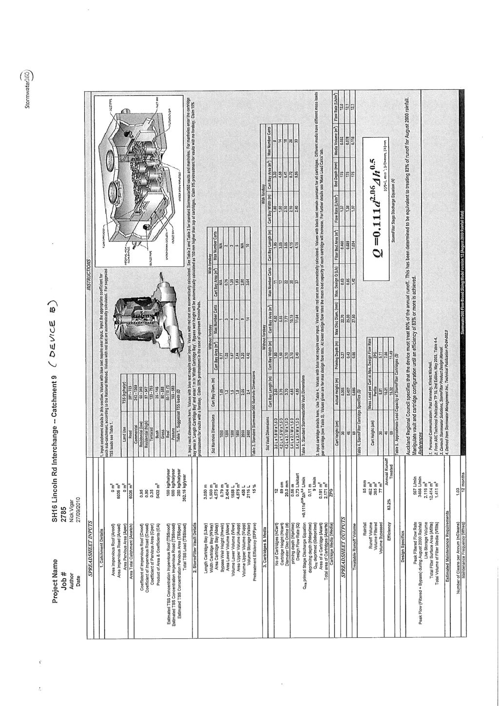
20 NZ Transport Agency SH16 Western Ring Route Henderson Creek to Huruhuru Road Bridge 7.3 Specific Device Details TP10 will be used as the design guideline for the design of treatment devices. The design of stormwater devices shall provide for the following: The minimum target adopted for treatment has been set out in TP10, i.e. to remove at least 75% of the total suspended solids on a long term average basis of the existing and proposed motorway surface, Stormwater devices will have facility for outlets to be manually shut through the use of penstocks or gate valves to enable capture of spilt fluids from the motorway. These elements will be developed through the detailed design phase, Maintenance access to each device will be provided via the road network or proposed access tracks. The Indicative Stormwater Design drawings (PD to PD-20813, within Volume 4 Plans and Drawings ) show the preliminary location of the stormwater treatment devices proposed for the motorway project. A summary schedule of preliminary proposed stormwater treatment devices for the project is presented in Table (in Section below) Proposed Treatment Devices Table 7.3-1: Summary of Preliminary Proposed Treatment Devices Device ID Location (at alignment centreline) Device A CH 6460 Westbound Device B CH 6460 Eastbound Device C CH 7110 Eastbound Wetland D CH 7150 Westbound Wetland E CH 7900 Westbound Contaminant Bearing Area 1 Treatment Device Details 0.7 hectares Cartridge Filters (14 No) & treatment trench 0.6 hectares Cartridge Filters (12 No) & treatment trench 0.5 hectares No treatment devices to be installed 3.75 hectares 1. Sediment Forebay 2. Water Quality Volume Wetland 5.57 hectares 1. Sediment Forebay 2. Water Quality Volume Wetland 1 Approximate total contaminant bearing surface area includes the Motorway, access ramps and other impermeable areas. 2 >75% TSS removal efficiency shall be achieved (in accordance with TP10). Device Size Filter chamber: 1.5m wide x 4.2m long x 1.5m deep Filter Chamber: 1.5m wide x 4.2m long x 1.5m deep TSS Removal Efficiency approx 75% 2 approx 75% 2 In-situ concrete chamber 0% 1.5m wide x 4.2m long x 1.5m deep 2No. 53m³ and 1@ approx 75% 2 86m³ Total area approximately 2300m² x 0.5m deep (permanent wet depth) with a maximum depth of 1m 206m³ approx 75% 2 Approximately 2800m² x 0.5m deep (permanent wet depth) with a maximum depth of 1m Status 09 Final (Rev 9) Page 15 October 2010 Document Reference No. AC-2-RPT-SW-001 AC2RPSW001-Rev9 Final (Oct 2010).doc
21 NZ Transport Agency SH16 Western Ring Route Henderson Creek to Huruhuru Road Bridge Devices A & B - Cartridge Filters (east of Henderson Creek) Run-off from the widened motorway for both eastbound and westbound lanes, from the high point at CH 6750 to CH 6460, is an approximately 290m long section. Two cartridge filter chambers have been identified as the most viable treatment option for the two small catchments in this location. The chambers will be located on both sides of the motorway at approximately CH These catchments are identified as subcatchments 9 and 10 on drawings PD to PD (Volume 4 Plans and Drawings ). Run-off will be intercepted by grated/slotted channel drains and catchpits and piped eastwards to the treatment device located on the verge of the motorway east of the Henderson Creek Bridge abutments at approximately CH Rip rap will be provided downstream for erosion control. The treatment devices will discharge the treated stormwater directly into the Henderson Creek. Flows above the WQ event will bypass the devices. Preliminary design and information from manufacturers indicates that one cartridge filter is required to treat approximately 500m² of carriageway surfacing to the TP10 standards (refer to Appendix B). In accordance with preliminary design information received from a cartridge filter manufacturer, removal efficiency by the proposed 14 no. cartridge filters on westbound side and 12 no. cartridge filters on the eastbound side would achieve a relative treatment performance greater than 75% TSS removal. The proposed chambers will be located outside of the carriageway below the motorway embankments. Maintenance access to the filter chambers will be gained from the bus shoulders and shared use path on the motorway. Localised traffic management will be required during maintenance operations. Consideration of Alternatives These cartridge filter devices have only been considered for use in this location because low impact devices (e.g. wetlands or ponds) cannot be provided in the area required due the proximity with the Coastal Marine Area, meaning unacceptable encroachment into the CMA would result, and also due to the low lying nature of the land in this area, resulting in incompatible levels. The design allows for future connection of run-off from these two subcatchments (9 and 10) to be directed to proposed softer treatment devices east of Henderson Creek, which will be incorporated into motorway improvements in the wider area. At this time these cartridge filter devices may be decommissioned Device C - Chamber Due to a low point on the carriageway occurring at CH 7080 it will not be practical due to level constraints and constructability to drain approximately 5900m² of the eastbound carriageway into Wetland D. As such it is proposed to collect the run-off via kerb channel and catchpits and discharge into a new insitu concrete chamber located under the eastbound shoulder at CH This is shown as Subcatchment 7 on drawings PD to PD (Volume 4 Plans and Drawings ). Status 09 Final (Rev 9) Page 16 October 2010 Document Reference No. AC-2-RPT-SW-001 AC2RPSW001-Rev9 Final (Oct 2010).doc
22 NZ Transport Agency SH16 Western Ring Route Henderson Creek to Huruhuru Road Bridge The chamber will act as an oversized manhole, combining the downstream outlets from the existing 900mm Culvert A and 450mm Culvert B, where they pass under the motorway. The final outlet from the main chamber will be connected to the upstream end of the existing 900mm diameter culvert C and will discharge via this culvert directly to the Coastal Marine Area (CMA). It is impracticable to fit typical TP10 devices at this location. Treatment cartridge filters in this chamber could provide the necessary water treatment, however, because of land constraints, the chamber would need to be located under the motorway bus shoulder. The practicality of accessing and maintaining the chamber makes this unfeasible. Filter cartridges require regular maintenance, and if installed in this location access would need to be gained from the bus shoulder introducing a safety conflict with the motorway on-ramp. Access to the chambers would require significant traffic management which would be disruptive to motorway traffic. The non-treatment of this small impervious area is not deemed significant given that the proposed stormwater management system for the overall project will achieve treatment of 95% of the final pavement areas Wetland D (Westbound Off ramp) A proposed wetland area, would be located on the southern side of the motorway adjacent to westbound offramp at between CH 6960 and CH The wetland will treat carriageway run-off from 3.75 ha, shown as subcatchments 5, 6 and 8 on drawings PD to PD (Volume 4 Plans and Drawings ). This encompasses the motorway area between the high point at CH 7550 (under the Selwood Road Bridge) to the high point at approximately CH 6740 (west of the Henderson Creek Bridges). It will also treat the westbound off-ramp, southeastern side of Selwood Road, and eastbound on-ramp. This total area equates to 4.34 ha, Subcatchment 7, which is 0.59 ha of this motorway carriageway catchment area, cannot be treated by Wetland D due to incompatible levels (refer Section above). Water quality will be managed by providing storage and residence time within the proposed stormwater wetland. The required treatment volumes have been derived using 1/3 of the two year 24 hour storm event in accordance with ARC Technical Publication TP 108 (refer stormwater calculations provided in Appendix A). The wetland will be designed in accordance with TP10 and will require permanent water storage to ensure that proper treatment of road run-off is achieved. The minimum target adopted for treatment is consistent with ARC TP10 - i.e. to remove at least 75% of the total suspended solids (TSS) on a long-term average basis. The wetland will be constructed by means of cut below existing ground levels, thereby only minimal fill for shaping and bunding will be required. A soils investigation has been undertaken in this area which has identified that the wetland will be located within a zone of Tauranga group silts/clays. Therefore the ground is considered to be suitable to maintain a wetland. If during construction areas of unsuitable material are encountered these will be excavated and replaced with clay. Any issues with infiltration or seepage around installed components can be addressed with at this stage. To minimise the surface area and any redundant or excessive storage volume, Wetland D will be split into two discrete sections - east and west. This reduces the land area required and subsequent property impacts. The base level of each section of the wetland will be at different levels to match the contours of the existing Status 09 Final (Rev 9) Page 17 October 2010 Document Reference No. AC-2-RPT-SW-001 AC2RPSW001-Rev9 Final (Oct 2010).doc
23 NZ Transport Agency SH16 Western Ring Route Henderson Creek to Huruhuru Road Bridge land and receiving outlet pipes/culverts. This arrangement has the further advantage of providing overland flowpaths for the existing upstream catchments around and between the wetlands. A plan and typical sections through the proposed wetland are shown on drawings PD to PD (Volume 4 Plans and Drawings ). Wetland Discharge and Outfall Discharge from the west wetland will be into existing Culvert A, then via Culvert C on the northern side of The Concourse, to an existing outfall to the CMA. During preliminary design it has been determined that the existing outfall has a peak discharge of 1.37m³/s. The rate at this outfall will not change. Flows over and above the WQ event, together with untreated run-off from the upstream catchment, will discharge to both the existing culvert (Culvert A) and an additional proposed culvert (Culvert K) via an open channel located between the wetland and the motorway embankment. Discharge from the east wetland will also be through this culvert (Culvert K). The new 1800mm (max) outfall culvert is proposed as the existing culverts, Culvert A (900mm dia) and Culvert B (450mm dia), which combine to outfall into Culvert C (900mm dia) currently receive discharge from 1.4 ha of motorway run-off together with an upstream catchment of agricultural and industrial land measuring 6.7 ha. Calculations indicate the existing culverts are insufficient in size to discharge unrestricted flows in the existing scenario and proposed. Calculations indicate that run-off from a 1 in 100 year event from the existing motorway and upstream catchment could generate 4.5m³/s of flow, whereas the capacity of the downstream Culvert C is only 1.37m³/s. The proposed widened motorway and contributing catchments could generate a 100 year peak flow of approximately 5.5m³/s. Plans of the existing and proposed catchments adjacent to the wetland are shown on drawing PD (Volume 4 Plans and Drawings ). The proposed Culvert K will be located beneath the westbound bus shoulder, between approximate chainage CH 6615 and CH 6915, and the flows will be piped eastwards over a length of 300m to discharge into the Henderson Creek at approximate CH 6615m. Preliminary design indicates that the new outfall at Henderson Creek may be required to discharge up to approximately 4.5m³/s. Scour protection will be provided at the outfall (refer to Appendix A for calculations). Consideration of Alternatives Due to minimal level differences between the finished motorway, the adjacent land and sea levels in this area, the options for the location of any treatment device are limited. The facility needs to be sized to accommodate the volume of stormwater to treat the largest possible area of the adjacent carriageway (as discussed in paragraph above). Both the physical size of the facility required and the levels in the area have dictated the proposed location of the wetland. The location at the natural low point of the motorway alignment maximises the catchment area that can be treated whilst taking best advantage of the topography and levels. This location also enables the re-use of the existing culvert outfall (Culvert C) to the CMA which in turn keeps the secondary outfall (Culvert K) as small as possible. Status 09 Final (Rev 9) Page 18 October 2010 Document Reference No. AC-2-RPT-SW-001 AC2RPSW001-Rev9 Final (Oct 2010).doc
24 NZ Transport Agency SH16 Western Ring Route Henderson Creek to Huruhuru Road Bridge Although wetlands are the preferred treatment solution by ARC (TP10) over ponds and other treatment devices, such as filtration-type treatment, other options have been considered for the necessary treatment device at this location:- A single larger wetland was initially investigated but through design development it was found to be more effective and also possible to reduce land impact, by splitting the wetland into two sections for the reasons discussed earlier. The total land area of an equivalent pond would be larger than that of the sectionalised wetland, or very similar to that of a single larger wetland, but under TP10 a pond is less desirable than a wetland as outlined above. Cartridge filters were also considered as an alternative option to a pond or wetland. However, as one filter can only treat 500m² of carriageway area, approximately seventy five cartridges would be needed to provide the equivalent treatment. A cartridge facility of this scale would be disproportionately expensive to construct and maintain. A wetland has been deemed the most appropriate treatment device for this area for several reasons including: The highest range of contaminants can be effectively removed by a wetland, The necessary footprint is achievable at this location, A wetland provides some benefits in terms of being naturally sustainable, A wetland provides enhanced habitat value, With a proposed operating depth of between 0.5 and 1 metre the hazards associated with deep bodies of water (i.e. ponds) are reduced, A wetland can be an attractive amenity and enhance urban design. A total contributing catchment of 3.75 hectares will be treated for the WQ event. The wetland will be located and designed to ensure that the longest possible drainage path is achieved, to maximise the retention times and optimise the treatment efficiency. Access for maintenance purposes will be provided from the shared use path adjacent to the westbound offramp. The location of the access is shown on drawing PD-20812, included in Volume 4 Plans and Drawings Wetland E (Huruhuru Creek) This treatment device, a proposed wetland, would be located south of the motorway carriageway near CH 7900 on the western side of Huruhuru Creek. The device will treat run-off from the carriageway from the motorway high point at CH 7550 (under Selwood Road Bridge), through to the motorway high point at CH 8450 (approximately 220m west of Huruhuru Road Bridge). The catchment also includes the Westbound On-ramp and Eastbound Off-ramp, the western side of Lincoln Road, the northern part of Selwood Road including the Status 09 Final (Rev 9) Page 19 October 2010 Document Reference No. AC-2-RPT-SW-001 AC2RPSW001-Rev9 Final (Oct 2010).doc
25 NZ Transport Agency SH16 Western Ring Route Henderson Creek to Huruhuru Road Bridge bridge. This is a total catchment area of 5.57 hectares, and is shown as subcatchments 1-4 on drawings PD to PD (Volume 4 Plans and Drawings ). Water quality will be managed by providing storage and residence time within the proposed stormwater wetland. The required treatment volumes have been derived using 1/3 of the two year 24 hour storm event in accordance with ARC Technical Publication TP 108 (refer stormwater calculations provided in Appendix A). The wetland will be designed in accordance with TP10 and will require permanent water storage to ensure that proper treatment of road run-off is achieved. The minimum target adopted for treatment is consistent with ARC TP10 - i.e. to remove at least 75% of the total suspended solids (TSS) on a long-term average basis. The wetland will be constructed by means of cut below existing ground levels, and only minimal fill for shaping and bunding will be required. A soils investigation has been undertaken in this area which has identified that the wetland will be located within a zone of Tauranga group silts/clays. Therefore the ground is considered to be suitable to maintain a wetland. If during construction areas of unsuitable material are encountered these will be excavated and replaced with clay. Any issues with infiltration or seepage around installed components can be addressed with at this stage. A plan and typical sections through the proposed wetland are shown on drawings PD and PD (Volume 4 Plans and Drawings ). Wetland Discharge and Outfall For this section of the motorway the low point is at about CH 7900, adjacent to the proposed wetland location. Final discharge will be piped to the existing channel located along the southern boundary of the revised designation, currently outfalling into the Huruhuru Creek. During preliminary design it has been determined that the outlet from the wetland to the existing outfall will have a peak discharge of 0.25 m³/s Flows in excess of the WQ event will bypass the wetland to a new proposed outfall in the CMA near Lincoln Bridge No. 1. Peak discharge at this proposed outfall may be approximately 2.0 m³/s. Refer to Appendix A for calculations. Some formalisation and reshaping may be required together with the installation of energy dissipation and local rip rap erosion protection at the wetland and pipe outfall points. Consideration of Alternatives Similarly to Wetland D assessment, other options considered for treatment at this location included filtration type treatment systems such as a sand filter. Because no extended detention or flood control is considered necessary, filtration type systems would be viable treatment solutions. However, during preliminary design it has been deemed that wetland treatment will be more appropriate here for several reasons including: That a wider range of contaminants would be effectively removed by a wetland, The treatment device footprint is achievable at this location, A wetland provides some benefits in terms of being naturally sustainable, A wetland provides enhanced habitat value, A wetland can be an attractive amenity. Status 09 Final (Rev 9) Page 20 October 2010 Document Reference No. AC-2-RPT-SW-001 AC2RPSW001-Rev9 Final (Oct 2010).doc
26 NZ Transport Agency SH16 Western Ring Route Henderson Creek to Huruhuru Road Bridge A total contributing catchment area of approximately 5.57ha impermeable area will be treated for the Water Quality Event. Landscaped/planted embankments and other permeable areas will drain to the existing culverts by swales, or clean water channels. Flows over and above the WQ event will be diverted upstream of the wetland to a bypass pipe discharging directly into the Huruhuru Creek. Detail design is required to confirm the final extent and shape of the wetland. The wetland will be located and designed to ensure that the longest possible drainage path is achieved, to maximise the residence times and optimise the treatment efficiency. Access for maintenance purposes will be provided from the shared use path adjacent to the westbound onramp. The location of the access is shown on drawing PD-20813, included in Volume 4 Plans and Drawings. Status 09 Final (Rev 9) Page 21 October 2010 Document Reference No. AC-2-RPT-SW-001 AC2RPSW001-Rev9 Final (Oct 2010).doc
27 NZ Transport Agency SH16 Western Ring Route Henderson Creek to Huruhuru Road Bridge 8. Maintenance Issues The proposed drainage network predominantly consists of commonly adopted elements, namely piped drainage, swales, kerb & channel and wetlands. This familiarity should assist greatly in establishing an effective maintenance regime. NZTA s agent responsible for the maintenance and operation of the Auckland motorway network is currently Auckland Motorways, or the Auckland Motorway Alliance (AMA). Auckland Motorways will be responsible for maintenance of the systems upon the completion of the construction contract period. The following maintenance provisions will be included within the drainage design requirements, and detailed in the Asset Owners Manual for future reference: Pipework/Catchpits/Channels Maintenance will be carried out in accordance with NZTA standard requirements. Wetlands - will be inspected frequently during the first three years during both growing and nongrowing seasons to observe plant species presence, abundance, and condition, bottom contours, and water depths relative to plans, sediment, outlet, and buffer conditions. Plants may require watering, physical support, mulching, weed removal, or replanting during the first three years. Nuisance plant species should be removed and desirable species should be replanted. Swales where ground conditions cannot be confirmed to be free draining, and for all swales with a longitudinal slope less than 2%, subsoil drains will be provided. Cartridge Filters will need to be inspected every six months for the first two years and then cleaned at yearly intervals. Isolating valves fitted to Stormwater devices which provide the ability for containment of hazardous substances, should they be spilt on the motorway, will need to be inspected every six months. 8.1 Durability All new culverts and culvert extensions and component members shall be designed to provide adequate durability in accordance with the requirements of the material design codes in NZTA Bridge Manual or relevant design codes, except where specific requirements are included: The design working life of proposed culvert structures is assumed to be 100 years in normal circumstances. The culvert and associated structures shall be designed with consideration of minimising maintenance requirements during the design life. Status 09 Final (Rev 9) Page 22 October 2010 Document Reference No. AC-2-RPT-SW-001 AC2RPSW001-Rev9 Final (Oct 2010).doc
28 NZ Transport Agency SH16 Western Ring Route Henderson Creek to Huruhuru Road Bridge Where culverts or piping material, other than concrete, are proposed (e.g. PVC, PE, etc.), demonstration of adherence to the longevity criteria will be needed by design. Structures shall be sufficiently durable to ensure that, without reconstruction or major renovation, they continue to fulfil their intended function throughout their design life. A condition assessment of existing culverts is proposed in order to assess any significant or serious risks to ongoing operation and maintenance of the culverts. 8.2 Erosion Protection To mitigate erosion at the interface between natural streams and culvert headwall / wing-walls, appropriate erosion control and energy dissipation measures shall be incorporated into the site specific design during detailed design. These shall be considered for the 10 year and 100 year design flows. Adequate erosion protection will be provided to facilitate the transition from pipe flow to natural channel flow. There is currently little or no erosion protection and it is not proposed to extend the designation boundary to accommodate extensive erosion protection, which calculations to recognised design standards could show to be required. Therefore, erosion protection will be provided within the available space. Status 09 Final (Rev 9) Page 23 October 2010 Document Reference No. AC-2-RPT-SW-001 AC2RPSW001-Rev9 Final (Oct 2010).doc
29 NZ Transport Agency SH16 Western Ring Route Henderson Creek to Huruhuru Road Bridge 9. Conclusions The project includes motorway pavement widening, widening and duplication of bridges, new on-and offramps, and the construction of a shared use path separate to the motorway carriageway. The proposal could have a range of short term and long term stormwater management related effects on the receiving environment. Best practicable measures will be taken to avoid, remedy or mitigate any resultant adverse environmental effects. A consistent approach to stormwater treatment has been adopted and consists of the use of treatment devices prior to the outfall to the coastal marine waters. No attenuation is required as the stormwater network outfalls to the coastal marine waters. The stormwater treatment proposes to treat 91% of the existing and 100% of the proposed motorway. This equates to treatment of a total impermeable catchment area of 10.6ha; in excess of 95% of the total motorway impermeable area (11.1ha). The overall benefit to stormwater quality as a result of the works is considered to be significant. Status 09 Final (Rev 9) Page 24 October 2010 Document Reference No. AC-2-RPT-SW-001 AC2RPSW001-Rev9 Final (Oct 2010).doc
30 NZ Transport Agency SH16 Western Ring Route Henderson Creek to Huruhuru Road Bridge Appendix A Stormwater Calculations Status 09 Final (Rev 9) October 2010 Document Reference No. AC-2-RPT-SW-001 AC2RPSW001-Rev9 Final (Oct 2010).doc
31
32
33
34
35
36
37
38
39
40
41
42
43
44
45
46
47
48
49
50
51
52
53
54
55
56
57
58
59
60
61
62
63
64
65 NZ Transport Agency SH16 Western Ring Route Henderson Creek to Huruhuru Road Bridge Appendix B - Cartridge Filter Information Status 09 Final (Rev 9) October 2010 Document Reference No. AC-2-RPT-SW-001 AC2RPSW001-Rev9 Final (Oct 2010).doc
66
67
68
Stormwater Solutions for Residential Sites. Section 2 Stormwater Management Approach VERSION 1.0. EcoWater Solutions. Prepared for
 VERSION 1.0 Stormwater Solutions for Residential Sites Section 2 Stormwater Management Approach Prepared for EcoWater Solutions A Department of Waitakere City Council 113 Central Park Drive Henderson WAITAKERE
MANUAL OF DESIGN, INSTALLATION, AND MAINTENANCE REQUIREMENTS FOR STORMWATER MANAGEMENT PLANS
 MANUAL OF DESIGN, INSTALLATION, AND MAINTENANCE REQUIREMENTS FOR STORMWATER MANAGEMENT PLANS May 2007 SECTION 1 Responsibility of Applicant TABLE OF CONTENTS A. Stormwater Management Plan Required Information
I611. Swanson North Precinct
 I611. Swanson North Precinct I611.1. Precinct Description Swanson North is located in the north eastern foothills of the Waitakere Ranges. It is outside the Waitakere Ranges Heritage Area Act and the Waitakere
SH20 Manukau Harbour Crossing Project Notice of Requirement Auckland City Council
 19 May 2006 (Updated 28 August 2006) Notice of Requirement Dated 19 May 2006: Updated 28 August 2006 Notice of Requirement Dated 19 May 2006: Updated 28 August 2006 Page i Form 18 Notice of Requirement
Urban Stormwater: Best Practice Environmental Management Guidelines. CSIRO This electronic edition published by CSIRO PUBLISHING, 2006.
 Urban Stormwater: Best Practice Environmental Management Guidelines. Chapter 5 Water Sensitive Urban Design Key references Department of Planning, 1993, Better Drainage: Guidelines for the Multiple Use
DFH JOINT VENTURE. Stormwater Management Report for Proposed Residential Subdivision at Graham Block, Pokeno
 DFH JOINT VENTURE Stormwater Management Report for Proposed Residential Subdivision at Graham Block, Pokeno DOCUMENT CONTROL RECORD Document: DFH Joint Venture Graham Block Stormwater Management Report
I615. Westgate Precinct
 I615. Westgate Precinct I615.1. Precinct Description The Westgate Precinct is located approximately 18km west of the Auckland city centre. There are seven Sub-precincts in the Westgate Precinct: Sub-precinct
CHECKLIST FOR PHASE II DRAINAGE REPORT
 I. COVER SHEET CHECKLIST FOR PHASE II DRAINAGE REPORT A. Name of Project B. Address C. Owner D. Developer E. Engineer F. Submittal date and revision dates as applicable II. GENERAL LOCATION AND DESCRIPTION
Pollutant Removal Benefits
 Bioswales Bioswales Similar to biocells, but have a slight, but positive grade toward an outlet Designed to convey the WQv event at very low velocities Promote filtration through native vegetation, infiltration
Draft Rhode Island Stormwater Design and Installation Standards Manual
 Draft Rhode Island Stormwater Design and Installation Standards Manual Summary The May 2009 Public Review Draft version of the RI Stormwater Design and Installation Standards Manual consists of approximately
PART C DESCRIPTION OF THE PROJECT
 PART C DESCRIPTION OF THE PROJECT 6.0 Description of the Project Overview This section includes the Project Description which provides the basis for the assessment of effects on the environment in Part
Appendix 18F: Tauriko Business Estate Services Strategy Statement and Sequencing Schedule
 Appendix 18F: Tauriko Business Estate Services Strategy Statement and Sequencing Schedule This statement describes key proposals for the development of infrastructure at Tauriko Business Estate. Appendix
4.6. Low Impact and Retentive Grading
 4.6. Low Impact and Retentive Grading Low Impact Grading techniques focus on utilizing existing topography during Site layout to minimize cost. Proposing structures, roads, and other impervious surfaces
Appendix K. Stormwater Management Plan
 Regional Municipality of Halton - Steeles Avenue (Regional Road 8) Class EA - Industrial Drive to Regional Road 25/Martin Street Appendix K Stormwater Management Plan PR226401.001 Rev. 2 PR.DOT, 00/01
Section 12C Subdivision in the Rural Residential Zone
 Section 12C 12C Subdivision in the Rural Residential Zone The Rural Residential Zone provides part of the range of residential opportunities within the City. Land zoned rural residential is considered
When planning stormwater management facilities, the following principles shall be applied where possible.
 2.0 Principles When planning stormwater management facilities, the following principles shall be applied where possible. 2.0.1 Drainage is a regional phenomenon that does not respect the boundaries between
STORMWATER MANAGEMENT PLAN: ERAND GARDENS X70
 STORMWATER MANAGEMENT PLAN: ERAND GARDENS X70 Client: Central Developments 09 April 2018 _ Rev00 Report no: SWMP/410/00 SWMP FOR ERAND GARDENS X70 TABLE OF CONTENTS 1 INTRODUCTION... 1 2 GENERAL INFORMATION...
POLICY SRT/D4 STORMWATER MANAGEMENT
 POLICY SRT/D4 STORMWATER MANAGEMENT BACKGROUND Increasing population, decreasing rainfall and increasing community expectations regarding environmental issues have led to increasing recognition of the
Leduc Industrial Outline Plan SE W4
 Leduc Industrial Outline Plan SE 1-50-25-W4 Within the North Leduc Industrial ASP Prepared for: Leduc Energy Park Ltd. Prepared by: Stantec Consulting Ltd. File No. 1161 104655 V5 Table of Contents 1.0
Lead Local Flood Authority SuDS Policy Statement
 Lead Local Flood Authority SuDS Policy Statement Meeting Sustainable Drainage System Standards in Hertfordshire Addendum to the Local Flood Risk Management Strategy for Hertfordshire March 2015 Contents
SPECIAL 35 (HIBISCUS COAST GATEWAY) ZONE
 ZONE") `` 12.8.35 SPECIAL 35 (HIBISCUS COAST GATEWAY) ZONE 12.8.35.1 Issues The following provisions relate to the Hibiscus Coast Gateway Zone. This zone is located at Silverdale in the area bounded by State
`` 12.8.35 SPECIAL 35 (HIBISCUS COAST GATEWAY) ZONE 12.8.35.1 Issues The following provisions relate to the Hibiscus Coast Gateway Zone. This zone is located at Silverdale in the area bounded by State
Chapter 4 - Preparation of Stormwater Site Plans
 Chapter 4 - Preparation of Stormwater Site Plans The Stormwater Site Plan is the comprehensive report containing all of the technical information and analysis necessary for the City to evaluate a proposed
WQ-23 MOUNTAINOUS AND STEEP SLOPE SITES
 Greenville County Technical Specification for: WQ-23 MOUNTAINOUS AND STEEP SLOPE SITES 1.0 Mountainous and Steep Slope Sites 1.1 Description The geographic locations of portions of Greenville County are
BACKGROUND INFORMATION DOCUMENT
 BACKGROUND INFORMATION DOCUMENT PROPOSED UPGRADING OF THE N2 NATIONAL ROAD FROM KRAAIBOSCH TO DIE VLEIE BASIC ENVIRONMENTAL IMPACT ASSESSMENT The South African National Roads Agency Society Limited (SANRAL)
4. CONCEPT PLAN DEVELOPMENT
 4. CONCEPT PLAN DEVELOPMENT Concept Plan Step 1: Identify Site Constraints and Opportunities Review the existing site to identify constraints and opportunities for GI Practices to meet the RRv. Constraints
15 Rural Residential Zone
 15 Rural Residential Zone Section 15A 15A Purpose of the Rural Residential Zone... 1 15A.1 Objectives and Policies of the Rural Residential Zone... 1 15A.2 Activity Status Rules... 5 15A.3 Permitted Activity
Appendix I. Checklists
 Appendix I Checklists Town of Greenwich Drainage Manual Department of Public Works - Engineering Division Town Hall - 101 Field Point Road, Greenwich, CT 06836-2540 Phone 203-622-7767 - Fax 203-622-7747
NON-TECHNICAL SUMMARY
 Proposed Sand and Gravel Extraction and Associated Processing Operations with Restoration to a Mixture of Agriculture and Nature Conservation including Areas of Shallow Water at Hedgeley, Northumberland
C. WATER. 1. Surface Water Runoff. See Section C.3, Flood Hazard/Mudflow Hazard, page Ground Water
 C. WATER 1. Surface Water Runoff See Section C.3, Flood Hazard/Mudflow Hazard, page 67. 2. Ground Water Determined not significant by the October 1984 and January 1999 Initial Studies conducted by the
LOUISIANA STATE UNIVERSITY COMPREHENSIVE & STRATEGIC CAMPUS MASTER PLAN. APPENDIX G - Stormwater Study Findings & Stormwater Solutions
 LOUISIANA STATE UNIVERSITY COMPREHENSIVE & STRATEGIC CAMPUS MASTER PLAN APPENDIX G - Stormwater Study Findings & Stormwater Solutions LSU: MP Narrative July 2017 3.5 Open Space Existing Conditions The
Water Sensitive Urban Design Site Development Guidelines and Practice Notes. Appendix
 Water Sensitive Urban Design Site Development Guidelines and Practice Notes Appendix 108 Appendix A Water sensitive developments involve simple design and management practices that take natural site features
5. LOW IMPACT DEVELOPMENT DESIGN STANDARDS
 5. LOW IMPACT DEVELOPMENT DESIGN STANDARDS Low Impact Development (LID) requires a shift in stormwater management away from conveying runoff to a small number of downstream points through hydraulically
A LARGE MULTI-FUNCTIONAL BIORETENTION DEVICE
 A LARGE MULTI-FUNCTIONAL BIORETENTION DEVICE Stephen Priestley 1 ABSTRACT In 2015, Ports of Auckland Ltd further developed their Wiri Inland Port site. This comprised an 8ha development of hard standing
PRELIMINARY DRAINAGE REPORT LATHAM 200 MMSCFD GAS PROCESSING PLANT
 PRELIMINARY DRAINAGE REPORT LATHAM 200 MMSCFD GAS PROCESSING PLANT LOTS B, RECORDED EXEMPTION 1211-2-1, RECX13-0096 LOCATED IN THE NORTH 1/2 OF SECTION 2, TOWNSHIP 3 NORTH, RANGE 66 WEST, 6 TH PRINCIPAL
APPENDIX A SIMPLIFIED APPROACH TO STORMWATER MANAGEMENT FOR SMALL PROJECTS. In West Sadsbury Township, Chester County, Pennsylvania
 APPENDIX A SIMPLIFIED APPROACH TO STORMWATER MANAGEMENT FOR SMALL PROJECTS In West Sadsbury Township, Chester County, Pennsylvania TABLE OF CONTENTS I. Introduction 3 II. Importance of Stormwater Management
Post Construction BMPs
 Post Construction BMPs Why are Post Construction BMPs important? With increased development brings the increase of impervious cover Parking lots, rooftops, driveways Storm water runoff volume increases
Olympic Park, London. SuDS used. 1. Location. 2. Description. Case study
 Olympic Park, London SuDS used Porous asphalt strips Wetlands Swales Filter strips Filter drains Balancing ponds Rainwater harvesting 1. Location Olympic Park, Stratford, East London, E20 2ST. 2. Description
New Development Stormwater Guidelines
 New Development Stormwater Guidelines CITY OF MOUNTLAKE TERRACE Table of Contents Introduction... 2 Ecology s Minimum Requirements for stormwater management... 2 Description of the 9 Minimum Requirements...
MASTER DEVELOPMENT DRAINAGE PLAN FOR MONUMENT HEIGHTS
 MASTER DEVELOPMENT DRAINAGE PLAN FOR MONUMENT HEIGHTS DRAINAGE REPORT STATEMENT ENGINEER'S STATEMENT: The attached drainage plan and report were prepared under my direction and supervision and are correct
South Bismarck Watershed Model Update and Stormwater Improvement Project
 Preliminary Engineering Report Bismarck Tribune South Bismarck Watershed Model Update and Stormwater Improvement Project City of Bismarck, ND January 2017 14.105.0046 1.0 Executive Summary The focus of
2 ALTERNATIVES AND OPTIONS
 2 ALTERNATIVES AND OPTIONS This chapter documents the process used to develop improvement concepts for Oregon Avenue and describes the resulting project alternatives and options, which were developed in
Lincoln 270. City of Lincoln. Stormwater Management Plan. April 2, 2013
 Lincoln 270 City of Lincoln Stormwater Management Plan April 2, 2013 # 2005.48 Prepared By: Civil Engineering Solutions, Inc. 590 E Street Lincoln, Ca 95648 (916) 645 5700 1.0 Background: The project site
(blank page) WestConnex New M Roads and Maritime Services Environmental impact statement
 WestConnex New M Roads and Maritime Services Environmental impact statement") (blank page) WestConnex New M5 5-42 (blank page) WestConnex New M5 5-44 5.5 Tunnels 5.5.1 Main alignment tunnels The main alignment tunnels would be about nine kilometres long, with the western tunnel
(blank page) WestConnex New M5 5-42 (blank page) WestConnex New M5 5-44 5.5 Tunnels 5.5.1 Main alignment tunnels The main alignment tunnels would be about nine kilometres long, with the western tunnel
McKay Road Interchange and Salem / Lockhart Crossing
 McKay Road Interchange and Salem / Lockhart Crossing The McKay Road Interchange Class EA has two components: 1. A new MacKay Road Interchange at Highway 400; and 2. A new bridge crossing of Highway 400
Appendix E Preliminary Location Hydraulic Study
 Appendix E Prepared for: State of Alaska Department of Transportation and Public Facilities Prepared by: HDR Alaska, Inc. 2525 C Street, Suite 305 Anchorage, Alaska 99503 February 2014 This page intentionally
North Branch of Cypress Creek Ecological Restoration: A Comprehensive Approach to Stream Restoration
 North Branch of Cypress Creek Ecological Restoration: A Comprehensive Approach to Stream Restoration Rocky Powell Clear Creeks Consulting, LLC Keith D. Tate, P.E. BayLand Consultants & Designers, Inc.
64 Mineral Extraction Area Rules
 64 Mineral Extraction Area Rules 64.1 Introduction For the purposes of this Chapter: Active Area, in relation to a Mineral Extraction Area (MEA), is that part of the Mineral Extraction Area which is owned
Urban Conservation Practice Physical Effects ESTABLISHMENT, GROWTH, AND HARVEST NUTRIENT MANAGEMENT
 NOT WELL 800 - Urban Stormwater Wetlands A constructed system of shallow pools that create growing conditions for wetland plants to lessen the impacts of stormwater quality and quantity in urban areas.
SECTION 7A: WHAKARONGO RESIDENTIAL AREA
 SECTION 7A: WHAKARONGO RESIDENTIAL AREA CONTENTS 7A.1 Introduction 1 7A.2 Resource Management Issues 1 7A.3 Objectives and Policies 1 7A.4 Methods 4 7A.5 Residential Zone 4 7A.5.1 Rules: Controlled Activities
Green City, Clean Waters
 Green City, Clean Waters Green Infrastructure Maintenance Manual Consent Order & Agreement Deliverable VIII City of Philadelphia Combined Sewer Overflow Long Term Control Plan Update Submitted to The Commonwealth
City of Richmond. Engineering Design Specifications
 City of Richmond Design Specifications June 2008 CITY OF RICHMOND ENGINEERING DESIGN SPECIFICATIONS JUNE 2008 THIS DOCUMENT DETAILS THE MINIMUM STANDARDS TO BE USED FOR THE DESIGN OF ENGINEERING PROJECTS
STAFFORD TRACT NORTH OF US90A 1.0 INTRODUCTION 1.1 OBJECTIVE
 1.0 INTRODUCTION 1.1 OBJECTIVE This report, prepared for submittal to TxDOT, analyzes existing and proposed detention facilities draining into the TxDOT US90A storm sewer system. The results of the detailed
Roads of national significance. MacKays to Peka Peka. Assessment of Environmental Effects: Non-Technical Summary
 Roads of national significance MacKays to Peka Peka Assessment of Environmental Effects: Non-Technical Summary March 2012 Table of Contents 1 Executive Summary... 1 1.1 Introduction... 1 1.2 Background
Retrofitting SuDS. Virginia Stovin. Department of Civil and Structural Engineering Pennine Water Group University of Sheffield.
 Retrofitting SuDS Virginia Stovin Department of Civil and Structural Engineering Pennine Water Group University of Sheffield Outline Urban stormwater management Conventional approach, problems and costs
DEALING WITH STORM WATER MANAGEMENT
 December 2012 DEALING WITH STORM WATER MANAGEMENT This fact sheet provides information on the guiding principles of storm water management practices, explains the difference between structural and non-structural
PLANNING AND DESIGN OF PUTRAJAYA STORMWATER MANAGEMENT SYSTEM
 PLANNING AND DESIGN OF PUTRAJAYA STORMWATER MANAGEMENT SYSTEM Khor Chai Huat, Chang Chan Yang & Lim Yek Lan Angkasa Consulting Services Sdn. Bhd. Abstract : Putrajaya is the new administrative centre of
ST. MARY S SOIL CONSERVATION DISTRICT (SMSCD) AND DPW&T CONCEPT EROSION AND SEDIMENT CONTROL AND STORMWATER MANAGEMENT GUIDELINES AND CHECKLIST
 AND DPW&T CONCEPT EROSION AND SEDIMENT CONTROL AND STORMWATER MANAGEMENT GUIDELINES AND CHECKLIST") St. Mary s Soil Conservation District 26737 Radio Station Way, Suite B Leonardtown, MD 20650 Phone: 301-475-8402 ext. 3 Fax: 301-475-8391 www.stmarysscd.com St. Mary s County Government Department of Public
St. Mary s Soil Conservation District 26737 Radio Station Way, Suite B Leonardtown, MD 20650 Phone: 301-475-8402 ext. 3 Fax: 301-475-8391 www.stmarysscd.com St. Mary s County Government Department of Public
Huntington Stormwater Utility
 Huntington Stormwater Utility Stormwater Management & Sediment and Erosion Control Requirements for Construction Sites Authorized by Huntington City Code Articles: 971, 970, 930, 935, 955, Revised April
Appendix D - Technical Design Criteria for BMPs
 Appendix D - Technical Design Criteria for BMPs City of Wayzata Page 3 On-site infiltration features Definitions and Scope: Infiltration facilities are constructed basins or depressions located in permeable
Bioretention cell schematic key
 Bioretention Cells Bioretention cell schematic key 1 3 Hardwood mulch 2 Curb cut 3 18-30 Modified soil 4 Stone aggregate choker layer 5 Stone aggregate base layer 6 Subdrain 7 Undisturbed soil 8 Overflow/Cleanout
Shelbyville, KY Stormwater Best Management Practices. Section 2 EROSION PREVENTION AND SEDIMENT CONTROL PLAN
 Section 2 EROSION PREVENTION AND SEDIMENT CONTROL PLAN 2.1 Requirements The City of Shelbyville, KY will require an Erosion Prevention and Sediment Control (EPSC) Plan for most types of development construction.
Grantham Southern Quadrant Link Road Environmental Statement
 Grantham Southern Quadrant Link Road Environmental Statement Non Technical Summary Introduction Lincolnshire County Council (LCC) is submitting a planning application for the proposed implementation of
Glencoe Elementary School Parking Lot Retrofit 825 SE 51 st Street
 Glencoe Elementary School Parking Lot Retrofit 825 SE 51 st Street Project Summary Project Type: Technologies: Institutional parking lot retrofit demonstration project Vegetated infiltration swale with
Lower Don River West Remedial Flood Protection Project TABLE OF CONTENTS. Page. Executive Summary
 TABLE OF CONTENTS Page Executive Summary 1.0 INTRODUCTION...1-1 1.1 Purpose of the Undertaking...1-1 1.2 Study Area Description...1-1 1.3 Description of the Undertaking...1-1 1.4 Rationale for the Undertaking...1-2
Floodplain Technical Memorandum
 Southeast Extension Project Lincoln Station to RidgeGate Parkway Prepared for: Federal Transit Administration Prepared by: Denver Regional Transportation District May 2014 Table of Contents Page No. Chapter
Public Consultation. Land at Monks Farm, North Grove. Welcome
 Welcome Welcome to our public exhibition for development on Land at Monks Farm, orth Grove. Gallagher Estates and Gleeson Strategic Land are preparing an outline planning application for new homes, open
CHAPTER 9 STORM DRAINAGE. Minimum Requirements for New Development and Redevelopment
 CHAPTER 9 STORM DRAINAGE 9.01 General The standards established by this chapter are intended to represent the minimum standards for the design and construction of storm drainage facilities. 9.02 Design
Appendices: Glossary. General Terms. Specific Terms. Low Impact Development Approaches Handbook
 67 67 General Terms Specific Terms 66 Low Impact Development Approaches Handbook The vocabulary of low impact development is evolving, and many terms are used interchangeably and to describe the same or
City of Hume Planning Scheme Amendment C207. Statement of Expert Evidence Provided to Planning Panels Victoria
 14 August 2017 Revision: 1 Reference: 1702 City of Hume Planning Scheme Amendment C207 Statement of Expert Evidence Provided to Planning Panels Victoria Stormwater Management Evidence for 35 Buckland Way
QUEENSTOWN LAKES DISTRICT COUNCIL SUBDIVISION DESIGN GUIDELINES
 Attachment C: Draft QLDC Subdivision Design Guidelines QUEENSTOWN LAKES DISTRICT COUNCIL DESIGN GUIDELINES A DESIGN GUIDE FOR AND DEVELOPMENT IN THE URBAN ZONES QUEENSTOWN OFFICE 10 Gorge Road Queenstown
Three Rivers Park District Administration Center Rain Garden
 Three Rivers Park District Administration Center Rain Garden Introduction There are significant changes to the hydrologic regime and nutrient loading following urban and industrial development. The post-development
Severn River Sub-Watershed: BMP 09-Retrofit
 Project ID: BMP_09 Total Treated Drainage Area: 4.57 acres Total Treated Impervious Area: 2.9 acres Total Water Quality Volume (WQv): ~10,300 cubic feet; 0.236 acre-foot Rainfall Depth Treated (Pe): 1
Authority. any changes required as a result of the approved CHMP.
 PLANNING PERMIT Permit No. Planning Scheme Responsible Authority../2013 Greater Geelong Planning Scheme Greater Geelong City Council ADDRESS OF THE LAND 5, 15, 21, 23, 1/23, 25, 33, 40 and 50 Caddys Road;
Figure 1 Cypress Street Study Area Location Map
 July 20, 2016 TO: FROM: Jim Massarelli Director of Engineering Jeff Julkowski, PE Michael Burke, PE SUBJECT: Cypress Street Study Area Stormwater Analysis (CBBEL Project No. 16-0058) At the request of
STORMWATER MANAGEMENT CODES ANALYSIS RICHLAND COUNTY, SC SITE PLANNING ROUNDTABLE
 STORMWATER MANAGEMENT CODES ANALYSIS RICHLAND COUNTY, SC SITE PLANNING ROUNDTABLE Codes analyses for each subcommittee were completed to assist participants of the Richland County Site Planning Roundtable.
ENBRIDGE GAS DISTRIBUTION INC. Proposed Relocation for Ninth Line, Markham and Whitchurch-Stouffville. Environmental Screening Report
 Page 1 of 18 ENBRIDGE GAS DISTRIBUTION INC. Proposed Relocation for Ninth Line, Markham and Whitchurch-Stouffville Environmental Screening Report July 2011 Page 2 of 18 Table of Contents 1.0 INTRODUCTION
City of Waco Stormwater Management Regulations
 1.0 Applicability: City of Waco Stormwater Management Regulations These regulations apply to all development within the limits of the City of Waco as well as to any subdivisions within the extra territorial
Key elements : Filter Strips must be designed within parameters required by the Fort Wayne s Development Standards/Criteria Manual.
 4.4. Filter Strips Filter Strips are densely vegetated lands that treat sheet flow storm water from adjacent pervious and impervious areas. They function by slowing runoff, trapping sediment and pollutants,
Town of Vershire Road Erosion Inventory Report
 Town of Vershire Road Erosion Inventory Report Taylor Valley Road. Photo taken by TRORC staff. Prepared by: 128 King Farm Road Woodstock, VT 05091 Inventory and report funded by the Vermont Agency of Transportation
6 BRIDGES. 6.1 Design philosophy. Proposed bridges
 SECTION 6 BRIDGES 6 BRIDGES Throughout the Project, bridges are a key visual element and marker for road users, pedestrians and cyclists. The design of bridges, as with other visible structures, has been
I602. Birdwood Precinct
 I602. Birdwood Precinct I602.1. Precinct description The Birdwood Precinct applies to an area west of Don Buck Road and south of Red Hills Road in west Auckland. It incorporates subdivision and development
VALLEY COUNTY MINIMUM STANDARDS FOR PRIVATE ROAD DESIGN AND CONSTRUCTION
 MINIMUM STANDARDS FOR PRIVATE ROAD DESIGN AND CONSTRUCTION Adopted November 28, 2005 TABLE OF CONTENTS DEFINITION OF TERMS...II I. DESIGN CRITERIA... 1 A. GENERAL DESIGN CRITERIA... 1 B. ROADWAY CLASSIFICATION...
ESSENTIAL ENGINEERING FOR PLANNERS
 ESSENTIAL ENGINEERING FOR PLANNERS Presented By Graham Coles, Urban Development Manager (Qld), Arcadis Australia Pacific 7 th March, 2017 Why Me? Biography A ground up background with over 17 years experience
STORMWATER FLOOD REPORT
 OREWA COASTAL RETIREMENT RESORT 25 ANNALISE PLACE OREWA for COASTAL PROPERTIES LTD STORMWATER FLOOD REPORT Job No. 1847 March 2016 Orewa Coastal Retirement Resort Page 1 of 9 CONTENTS Item Description
Planning the BMP. Region 2000 Planning District Commission Lynchburg, VA December 13, 20013
 Planning the BMP Region 2000 Planning District Commission Lynchburg, VA December 13, 20013 PLANNING THE BMP AGENDA BMP Selection BMP Design SWM Plan Preparation 2 BMP SELECTION Types of BMPs Structural
STORMWATER SITE PLAN INSTRUCTIONS AND SUBMITTAL TEMPLATE Medium and Large Projects
 DEPARTMENT OF COMMUNITY DEVELOPMENT 621 Sheridan Street, Port Townsend, WA 98368 Tel: 360.379.4450 Fax: 360.379.4451 Web: www.co.jefferson.wa.us/communitydevelopment E-mail: dcd@co.jefferson.wa.us STORMWATER
Hopwood Motorway Service Area, Worcestershire
 Hopwood Motorway Service Area, Worcestershire SuDS used Grass filter strip Stone collector trench Spillage basin Grass swale Balancing ponds Wetland ditch Wetland treatment Sub-surface collector trench
Northern Branch Corridor DEIS December 2011
 16 Floodplains 161 Chapter Overview 1611 Introduction The flowing chapter identifies floodplains found within the Northern Branch Corridor in accordance with Executive Order 11988, Floodplain Management
This Chapter includes an outline of the design and form of the proposed Expressway Project.
 PART D: DESCRIPTION OF THE PROJECT 7 Operation of the Project Overview This Chapter includes an outline of the design and form of the proposed Expressway Project. The Project is defined as the design,
Placement of the soil should be in lifts of mm and loosely compacted (tamped lightly with a backhoe bucket).
.") 6 Rain Gardens Rain Gardens 6.1 Introduction A rain garden is used to attenuate peak flows and to provide stormwater treatment. Rain gardens use the concept of bioretention, a water quality practice in
6 Rain Gardens Rain Gardens 6.1 Introduction A rain garden is used to attenuate peak flows and to provide stormwater treatment. Rain gardens use the concept of bioretention, a water quality practice in
Stormwater Management Plan (SWMP) Revision Date: 11/05
 Revision Date: 11/05") Stormwater Management Plan (SWMP) Revision Date: 11/05 SWMP Purpose: Sustainable stormwater management principles are adopted as Portland State University s (PSU) preferred approach for the management
Stormwater Management Plan (SWMP) Revision Date: 11/05 SWMP Purpose: Sustainable stormwater management principles are adopted as Portland State University s (PSU) preferred approach for the management
GUIDELINES FOR ECOLOGICAL PERFORMANCE
 3 Landscape........................................... 3.2 Stormwater Management................................... 3.3 Hardscape........................................... 3.4 Streetscape..........................................
Alma Road Rain Gardens, London
 Alma Road Rain Gardens, London SuDS used Rain gardens Permeable paving Tree planting Benefits 1. Location Reduction in flooding from intense rainfall. Reduced surface water pollution to receiving water
Rule D Wetland and Creek Buffers
 Rule D Wetland and Creek Buffers 1 Policy It is the policy of the Board of Managers to ensure the preservation of the natural resources, recreational, habitat, water treatment and water storage functions
TOWN AND COUNTRY PLANNING ACT 1990 (AS AMENDED).
.") FAO: D. Williams Isle of Anglesey County Council Council Offices Llangefni Anglesey LL77 7TW 16 November 2017 DCRM Ref. No: WN0904-QUD-OS-LET-00002_English Dear Mr Williams TOWN AND COUNTRY PLANNING ACT
FAO: D. Williams Isle of Anglesey County Council Council Offices Llangefni Anglesey LL77 7TW 16 November 2017 DCRM Ref. No: WN0904-QUD-OS-LET-00002_English Dear Mr Williams TOWN AND COUNTRY PLANNING ACT
Lincoln Road Corridor Improvements. Notice of Requirement to Auckland Council from Auckland Transport. Assessment of Effects on the Environment (AEE)
") Lincoln Road Corridor Improvements Notice of Requirement to Auckland Council from Auckland Transport Assessment of Effects on the Environment (AEE) 1 Assessment of Effects on the Environment prepared by:
Lincoln Road Corridor Improvements Notice of Requirement to Auckland Council from Auckland Transport Assessment of Effects on the Environment (AEE) 1 Assessment of Effects on the Environment prepared by:
Section 12B 12B Subdivision in Residential Zones
 Section 12B 12B Subdivision in Residential Zones The Residential Zones provide for a range of infill and greenfield living opportunities across the City for the community to accommodate current and future
TABLE OF CONTENTS. Sierra Springs Outline Plan
 Sierra Springs Outline Plan TABLE OF CONTENTS 1. Introduction...3 1.1. Purpose of the Plan... 3 1.2. The Approval Process... 3 1.3. Policy and Legislative Framework... 3 2. Development Area...6 2.1. Location
City of Fort Worth. December 1, 2004
 City of Fort Worth December 1, 2004 Storm Water Issues in our Region Disappearing water features and habitat Erosion and degradation of natural streams Flooding in new and old developed areas Pollutants
Public Information Centre # 2 Coronation Park Drainage Improvements Town of Oakville Municipal Class Environmental Assessment
 November 26, 2014 Public Information Centre # 2 Coronation Park Drainage Improvements Town of Oakville Municipal Class Environmental Assessment Study Area & Drainage System Legend Coronation Project Park