Before the Environment Court at Auckland ENV-2013-AKL
|
|
|
- Dominick Fox
- 5 years ago
- Views:
Transcription
1 Before the Environment Court at Auckland ENV-2013-AKL In the Matter of the Resource Management Act 1991 And In the Matter of Notice of Motion under Section 87G requesting the granting of resource consents to Waiheke Marinas Limited to establish a Marina at Matiatia Bay, Waiheke Island, in the Hauraki Gulf Evidence of Robert James Pryor on behalf of Waiheke Marinas Ltd Dated 29 April 2014 Richard Brabant/Jeremy Brabant Barristers Broker House, Level 2, 14 Vulcan Lane PO Box 1502, Shortland St Auckland City Ph: Fax: richard@brabant.co.nz/jeremy@brabant.co.nz 1
2 Introduction 1. My full name is Robert James Pryor. 2. I hold a Bachelor of Science degree in Psychology from Otago University (1980) and a post-graduate Diploma of Landscape Architecture from Lincoln University (1984). I am a registered member of the New Zealand Institute of Landscape Architects and have practised as a landscape architect in the following capacities: (a) (b) (c) Landscape Architect for Wellington City Council; Director of the Wellington-based consultancy, Bannatyne Pryor Associates; and Director of LA4 Landscape Architects, Auckland. I am currently a director of LA4 and have been since I have 30 years experience undertaking landscape assessments for clients in both the public and private sectors on a wide variety of major projects within a range of landscape settings. Relevant projects include: (a) Ara Tuhono Puhoi to Wellsford Road of National Significance (b) Springhill Men s Corrections Facility; (c) Southern Auckland Women s Correctional Facility; (d) Aquaculture Farms; (e) Whakapapa Ski Area Development; (f) Turoa Ski Area Development; (g) Beachlands Village Business Centre Private Plan Change; (h) Dominion Road Transport Designation; (i) AMETI Transport Corridor; (j) Waikato Expressway; (k) Southern Links; (l) North Shore Hospital Private Plan Change; (m) Milford Town Centre Private Plan Change; (n) Vector Broadband Fibre Network Rollout; (o) Drury and Huntly Quarry Expansions; (p) Franklin District Growth Strategy; (q) Westfield St Lukes Private Plan Change; (r) Mangere and North Shore Wastewater Treatment Plants; 1
3 (s) (t) Massey North Town Centre Comprehensive Development Plan; and Hobsonville Neighbourhood Centre Comprehensive Development Plan. 4. I was instructed by Waiheke Marinas Ltd in July 2010 to undertake a preliminary landscape and visual effects assessment of the proposed marina. In February 2011 I prepared the Assessment of Landscape and Visual Effects Report for the initial scheme utilising the floating attenuator. 5. I am the author of the Assessment of Landscape and Visual Effects Report, March 2013 that informed the Assessment of Environmental Effects (AEE) lodged in support of the Project. In March 2014 I also undertook site investigations and preliminary assessments of a number of alternative sites. 6. I have also reviewed the s92 requests, s87f report and submissions. 7. I am familiar with the area to which the application for resource consent relates. I have visited the site and surrounds on numerous occasions since 2010, most recently on 11 March I record that I have read and agree to abide by the Environment Court s Code of Conduct for Expert Witnesses as specified in the Environment Court s Consolidated Practice Note This evidence is within my area of expertise, except where I state that I rely upon the evidence of other expert witness as presented to this hearing. I have not omitted to consider any material facts known to me that might alter or detract from the opinions expressed. Scope of Evidence 9. My evidence outlines the existing landscape character of the site and locality, identifies the key landscape and seascape features of the area, describes those elements of the proposal that will be visible from outside the site and assesses their landscape, natural character and visual amenity effects on the locality. 10. My evidence will address the following: 2
4 (a) (b) (c) (d) (e) (f) (g) Description of the proposed marina; Description of the site and surrounding coastal environment; Evaluation of the landscape, visual, amenity and natural character effects; Statutory considerations; Comment on Council s s87f report; Comment on submissions and s274 parties; and Conclusions. The Proposed Marina 11. The proposal has been fully described within the application. Essentially the proposal involves the construction of a 160-berth marina in the northeastern corner of Matiatia Bay adjacent to the existing ferry terminal and wharf. The key visual components of the marina are: (a) (b) (c) (d) (e) (f) (g) (h) (i) (j) (k) marina of approximately160 berths primary armour rock breakwater approximately 130m long with piled end panels for additional wave protection, with pedestrian footpath accessing a viewing platform at the southern end secondary armour rock breakwater approximately 75m long to the northwest of the primary rock breakwater 4m wide southern access pier that also acts as a wave attenuator four, 2m wide internal piers (A-D) with 1m wide finger jetties 160 piles (ranging between 250mm and 600mm diameter) low-level security lighting navigation markers 20 pile moorings (17 craft) either a reclamation area or piled deck with car parking, landscaping and public amenity areas timber viewing deck (l) timber walkway from the reclamation accessing the DoC reserve and foreshore (m) floating marina office with dinghy racks 3
5 Breakwaters 12. The visible outer armouring of the breakwaters will be specially selected rock. The rock is to be sourced from a quarry in the Coromandel and will be similar to the rock used in the breakwater at the Kennedy Point ferry landing. This particular rock has been selected as it closely resembles the colours and textures of the local Waiheke rock that will assist it blending into the surrounding coastal setting. 13. The extent of visibility of the breakwater will vary according to the tidal variation. At mean high water springs (MHWS) approximately 1.6m to 1.7m of breakwater will be exposed. At mean low water springs (MLWS) between 4.2m and 5.1m will be visible. This maximum level of exposure will however be of short duration while the tide is turning. 14. The 1.5m wide footpath extending along the primary breakwater will be constructed of concrete tinted to match the colour of the rock armour. This will provide a smooth and even surface set into the rock armour. Landscape Design 15. A number of landscape design considerations have been incorporated into the marina proposal as illustrated on the Landscape Plan prepared by LA4 Landscape Architects in Appendix RP Specimen tree plantings of pohutukawa (Metrosideros excelsa) are proposed within the reclamation area car park to soften the expanse of the paved area. These will be mass under planted with the hardy coastal pohuehue (Muehlenbeckia complexa) groundcover. (With the parking deck option, the pohutukawas would be planted in generously dimensioned above ground planters). 17. A pedestrian footpath extends around the periphery of the car park. A timber viewing deck is to be provided on the northern side of the 4
6 reclamation. With the deck option the footpath will include a viewing area on the same corner as the reclamation option. A timber boardwalk provides access to the foreshore and Matietie Historic Reserve. Access is currently unavailable, approximately 1.5 hours either side of high tide. The Site and Surrounding Environment 18. The proposed marina is located on the northeastern side of Matiatia Bay. Photograph 1 is taken from the coastal walkway on the northern side of the bay looking east towards the site. 19. Matiatia Bay is the main arrival point by public ferry for Waiheke Island from Auckland. It is a small and narrow west-facing bay defined by two rocky headlands. Te Whetumatarau Point forms the southern headland. The bay is enclosed by the east-west running ridgelines and steep slopes that drop down into the bay to the north and south. A more open valley extends up from the bay in an easterly direction along which Ocean View Road runs. 20. The bay is characterised by its steep slopes, rocky cliffs and rocky shoreline interspersed with small beaches. Photograph 2 illustrates the coastal edge in the vicinity of the site. The two main stony beaches extend along the eastern coastline physically separated by the small knoll where the ferry terminal is located. Mature plantings of coastal pohutukawa trees cling precariously to the rocky cliffs and along the foreshore in places. The bay is exposed to the prevailing southwesterly winds. 21. The sea within the bay is dynamic due to constantly changing weather, wind and light conditions presenting a variety of surface variations. Tidal variation also presents a changing sea/land interface with a sharper and more distinct linear definition at low tide. 22. Large-lot residential development has established on the surrounding slopes and the previously open pastoral landscape has been transformed into one with prominent and large dwellings set 5
7 into a densely vegetated and maturing landscape. A number of olive plantations have been planted, contrasting with the prevailing indigenous revegetation patterns. Pasture is still prevalent on some of the upper slopes, although largely maintained by mechanical methods. 23. Within the bay itself are over 90 swing moorings largely in the northern and southern mooring areas and separated by the ferry passage. A boat haul out grid with timber piles is located in the northern bay. A public reserve extends around the coast and incorporates the popular walkway accessing Owhanake Bay to the north and Church Bay to the south. 24. DoC s Matietie Historic Reserve adjoins the site to the north and east and extends inland a short distance from mean high water mark. The reserve is largely undeveloped with the majority of it being on the steep slopes. Pedestrian access from Ocean View Road to the reserve is difficult at high tide with the water extending up to the cliff edge. A flatter grassed area is in the northeastern corner with pedestrian access to the coastal walkway and Delamore Drive. Several derelict buildings are located in the vicinity. Photograph 3 is taken from the reserve looking along the foreshore in a westerly direction. The larger building with the grey roof is on privately owned property. Beyond the reserve to the north and east are privately owned properties. 25. Ten properties are accessed off Delamore Drive and Alan Murray Lane and have outlook across the bay (one of which is still to be developed). They are characterised by large dwellings surrounded by revegetation plantings of indigenous species. Several accommodation facilities, including The Moorings Studio Apartments and Matiatia Bay are located on the elevated eastern slopes overlooking the bay. 26. A short distance to the south of the marina site is Waiheke Island s ferry terminal. The wharf and ferry terminal building act as the main transport terminal for passenger ferry services to and from Waiheke. 6
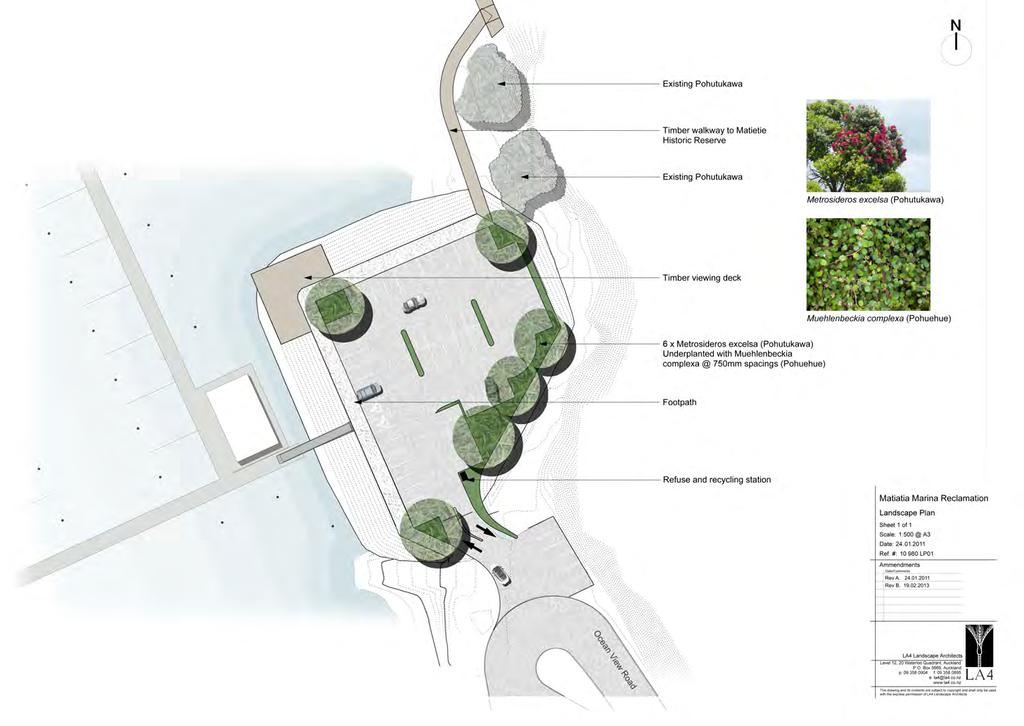
8 27. Between this facility and the marina are a wharf, the coastguard berth, and a boat launching ramp. The ferry terminal occupies a prominent site and is a constant source of activity with ferries arriving and departing at regular intervals from 6am until 12.30pm Mon Fri, 7.15am 12.30am Sat and 8am 11.15pm Sun. The other wharf is used by commercial and recreational vessels for loading and unloading, and for the coastguard activities using the pontoon. 28. To service the ferry arrivals and departures, passenger transport services are located to the rear of the ferry building. Here, there are buses, vans and taxis dropping off and collecting as well as large numbers of residents and visitors alighting and disembarking. Photograph 4 is taken from the coastal walkway to the north of the bay looking in a south-easterly direction towards the wharves, ferry terminal and boat launching ramp. 29. To the southeast of the ferry terminal is the large sealed public car park and overflow grassed parking area accessed off Ocean View Road servicing the ferry wharf. A number of commercial activities are located in the vicinity including car and motorbike rental, bike hire and sea kayak and canoe hire. Further east along Ocean View Road is another large sealed car park with a number of privately owned vehicle garages on the northern side of the road. Photograph 5 is taken from the coastal walkway to Church Bay looking in a northeasterly direction towards the area. 30. Matiatia Bay, although flanked and strongly enclosed by a range of natural features and elements including the coastal headlands, ridges, revegetating slopes, rocky foreshore and inter-tidal zone, is however dominated by the man-made structures and elements of the wharf, ferry terminal, parking areas, and commercial developments. These introduced components of the bay provide a strong focus and feature at the gateway to Waiheke Island. 31. The surrounding coastal environment into which the proposed marina would fit comprises several contrasting landscapes/ seascapes. The western outer bay is high in natural character due to the rocky foreshore and rugged coastline extending into the 7
9 channel. The eastern inner bay, in contrast, has a distinctly modified character through the maritime activities and infrastructure associated with the ferry terminal, wharves and road network. 32. The area is intensively utilised both day and night and is dynamic in nature due to the wide range of land and harbour based activities. The ever-changing nature of the area through boating activities, ferry movements and boat moorings as well as the vibrant activity of the ferry terminal and the attraction of the area as a tourist destination results in a diverse, highly active and modified environment. Matiatia is the transport gateway for the island, for residents, commercial couriers and visitors and as such forms the activity hub for the island on a daily basis throughout the year. The ferry terminal is in operation from the first morning sailing at 6am until the final departure at 12.30am, Monday to Saturday. 33. As a result there are a number of physical components and their associated activities that shape the immediate neighbourhood character of the Matiatia Bay marina site and its wider coastal setting which I have considered when undertaking the assessment of landscape and visual effects of the proposal. Looking ahead I understand the likelihood is that these uses and new commercial buildings and activities provided for by the mixed use zone applying to the terminal hinterland will further tip the balance away from the landscape and amenity values of the natural environment, and reflect an increased maritime presence coupled with new commercial and tourist-related uses. 34. The components are: (a) (b) (c) (d) the sense of semi-containment within the bay; the contrasting character of Matiatia Bay with the natural characteristics of the outer bay (western end) contrasting with the highly modified inner bay (eastern end); the diverse nature of the foreshore and changing nature of the land/sea interface; the dynamic nature of the water environs through the prevailing maritime activities boats, ferries, launches, coastguard and charter boats in and around the bay; 8
10 (e) (f) (g) the commercial characteristics of the bay the ferry terminal and ferry movements, arrival and departure zone, loading wharf, launching ramp, car, motorbike, bike and kayak rental outlets and the utilitarian nature of the extensive car parking areas; the established residential settlement pattern on the slopes surrounding the bay; and the mosaic vegetation patterns on the slopes with indigenous plantings interspersed with more open pasture and horticultural plantings. 35. Neither Matiatia Bay nor the surrounding coastal area is identified as an Outstanding Natural Landscape in the ARPS or Change 8 maps (Map 15). Evaluation of the Proposal 36. I consider the potential landscape, visual, amenity and natural character effects of the Project as they relate to the RMA to be: (a) (b) (c) Effects on the natural character of the coastal environment: s6(a); Effects on amenity values: s7(c); and Effects on the quality of the environment: s7(f). Visual Effects 37. The assessment of visual effects analyses the perceptual (visual) response that any of the identified changes to the landscape may evoke, including effects relating to landscape character and landscape values. Visual sensitivity is influenced by a number of factors including visibility of a proposal, the nature and extent of the viewing audience, the visual qualities of the proposal, and the ability to integrate any change within the landscape setting where applicable. The nature and extent of visual effects are determined by a systematic analysis of the visual intrusion and qualitative change that a proposal may bring, specifically in relation to aesthetic considerations and visual character and amenity. 38. The methodology used in this part of the evidence is designed to assess whether or not the proposed marina would have more than minor adverse visual effects on the nature and quality of the 9
11 surrounding environment, both in the wider and the particular aspect (i.e. in relation to wider and specific viewpoints).. The process of analysing such effects involves: a) Identification of the physical area or catchment from which the proposed marina would be visible; b) Identification of the different viewing audiences that would be affected by the development followed by the allocation of viewpoints to positions that capture those audiences perspective; c) Evaluation of the effects taking into account the preceding analysis. The Visual Catchment and Viewing Audience 39. The visual catchment is the physical area that would be exposed to the visual changes associated with the proposed marina. The enclosed nature of Matiatia Bay means that views will be restricted to those entering the bay, within the bay and residing / recreating on the surrounding slopes. 40. The largest single catchment is that of Matiatia Bay and the view experienced by the residents, visitors and recreational users of the bay, foreshore and coastal walkway. 41. A more distant catchment is that of the recreational boaties in the channel approaching Matiatia Bay. The enclosing headlands however mean that these views will be highly restricted by the landform and at a distance that would render the marina indiscernible from the background shoreline. 42. Based on the viewing catchments identified, the following groups comprise the main audience that will be exposed to the proposed marina: (a) (b) residents and visitors in the dwellings within Matiatia Bay overlooking the marina site; residents, visitors, tourists and workers on ferries and vessels entering into and departing from the bay; 10
12 (c) (d) recreational boaties and recreational users of the bay; and recreational users of the coastal walkway. 43. The visual effects of the proposed marina have been assessed from a number of representative viewpoints within the visual catchment area that have potential for landscape and visual effects. 44. Seven public viewpoints and five private viewpoints have been identified from which the landscape and visual effects have been assessed. This is achieved by using both descriptive and analytical means. The viewpoints were selected as locations that in my opinion capture and fairly represent the range of public and private views towards the proposed marina. 45. The assessment is from each of the following public viewpoints: Viewpoint 1: Matiatia Bay entrance Viewpoint 2: Northwestern slopes Viewpoint 3: Coastal Walkway to Owhanake Bay Viewpoint 4: Foreshore adjoining Matietie Historic Reserve Viewpoint 5: Northern slopes Viewpoint 6: Ferry terminal wharf Viewpoint 7: Coastal Walkway to Church Bay 46. Photographs have been taken by Buildmedia and visual simulations prepared from the seven viewpoints at both high and low tides. A detailed assessment and analysis of the potential landscape and visual effects of the development has been carried out using a Visual Effects Matrix (score sheet) that ensures that each view and changes within each view are evaluated thoroughly and consistently. 47. The key factors contained in that matrix are given in detail in Appendix RP2. It covers aspects such as the sensitivity of the view to change, the size of the viewing audience that would be affected, the legibility of the proposal, how well the proposal integrates with its surroundings and whether or not the proposal intrudes into any existing views. 48. The level of effect corresponds to a relationship between the 11
13 sensitivity of the existing environment or view, and the degree to which the natural character, landscape or visual baseline will be changed. The process requires an assessment of the level of sensitivity to be combined with an assessment of the magnitude of change. 49. The following five-point scale has been used to rate effects, based on the scale provided in the NZILA Best Practice Note 2010: Very High / High / Moderate / Low / Very Low The total ratings given in the descriptions denote the overall visual effects rating, which has the following range of potential ratings and effects from each viewpoint. Very Low Effect The proposal has discernable effects but too small to adversely affect other persons. Low Effect The proposal constitutes only a minor component of the wider view. Awareness of the proposal would not have a marked effect on the overall quality of the scene or create any significant adverse effects. Moderate Effect The proposal may form a visible and recognisable new element within the overall scene and may be readily noticed by the viewer. The proposal may cause an adverse impact but could potentially be mitigated or remedied. High Effect The proposal forms a significant and immediately apparent part of the scene that affects and changes its overall character. The proposal may cause a serious adverse impact on the environment but could potentially be mitigated or remedied. Very High Effect The proposal becomes the dominant feature of the scene to which other elements become subordinate and it significantly affects and changes its character. The proposal causes extensive adverse effects that cannot be avoided, remedied or mitigated. Analysis of Results 50. The following summaries describe the implications that the proposed marina development has for each of the viewpoints. In so doing they touch on key findings in the matrix analysis and the implications that these might have for areas and audiences in close proximity to any given viewpoint. 12
14 Viewpoint 1: Matiatia Bay entrance 51. Viewpoint 1 is taken from the ferry entering into Matiatia Bay looking in an easterly direction towards the site. This view is at a distance of approximately 400m away from the marina site. This is a public view, which in the context of the island would be experienced by relatively high numbers of people, both local residents and visitors who access the island by ferries and other vessels using the Matiatia Bay wharf. It is also indicative of the views of recreational boaties entering into the bay. 52. The view portrays the contrasting characteristics of the outer and inner bay with the more modified characteristics of the eastern end apparent with the ferry terminal and wharves and the residential settlement pattern on the surrounding slopes. The boats on the swing moorings and activities associated with the wharf reinforce the maritime characteristics of the bay. The large residential dwellings set within the contrasting vegetation patterns further reinforce the diverse nature of the landscape. 53. This landscape/seascape has a moderate to high visual absorption capability rating. The land/sea interface is diverse with the rocky shoreline, stony beaches and rock embankment retaining structures on the reclamation area. The shoreline and landform against which the marina will be viewed are characterised by the indented coastline with revegetated slopes interspersed with pasture and residential settlement. The water surface, in contrast, creates a flat plane and natural element in the otherwise diverse landscape. 54. From this lower viewing angle the most visible feature of the marina will be the rock breakwater, particularly when viewed at low tide. While of a more engineered nature, the breakwater would not appear incongruous in the context of the rocky foreshore and land/sea interface. The upper portion and masts of the moored vessels would be visible within the marina itself and would be viewed in a more orderly fashion than those on the existing swing moorings. 55. The marina would be viewed in the context of the existing maritime characteristics of the bay the wharves, ferry terminal and moored 13
15 vessels. The degree of intrusion that the marina offers is therefore limited by these elements that are already an established part of the Matiatia Bay environment. 56. As depicted in the photomontage the marina merges into the background. The photograph was taken close to low tide illustrating the maximum extent of visual exposure the rock breakwaters would have out of the water. The view is also subject to the ever-changing nature of the bay with boat movements and berthage turnover resulting in daily variations to the scene. 57. From here the marina will be viewed as an integral component of the existing coastal environment and in my opinion the landscape and visual effects will be low in the context of the surrounding coastal environment. Viewpoint 2: Coastal Walkway to Owhanake Bay Viewpoint 3: Northwestern slopes 58. These more elevated perspectives are taken from the northwestern slopes above Matiatia Bay. Viewpoint 2 is taken from the coastal walkway that runs between Matiatia Bay and Owhanake Bay looking in a southeasterly direction towards the site. Viewpoint 3 is taken from a private viewing location looking east. The views extend across the bay towards the ferry terminal and public car park accessed off Ocean View Road. 59. These views are extensive (only part of which is depicted in the photographs) and again portray the more modified characteristics of the eastern end of the bay. The views depict the working and recreational maritime nature of the environs. The ferry terminal and wharves reinforce the maritime characteristics and the residential dwellings sitting within the vegetated slopes and atop the skyline reinforce the established settlement pattern. The moored boats in the bay and the regular movements of the Fullers and Pinehaven ferries, coastguard and other commercial and recreational vessels result in a dynamic and ever-changing seascape. 60. From these close locations the marina will introduce a more 14
16 modified and ordered structure into the bay. However marinas are an integral component of coastal environments where ferry terminals are located (e.g. Half Moon Bay, Bayswater, Gulf Harbour and Westpark marinas) and this part of the bay is already heavily modified with built infrastructure associated with the wharves and ferry terminal as well as the residential settlement pattern on the slopes surrounding the bay. The marina will not adversely effect the more natural characteristics and appearance of Matiatia towards the outer or western end of the bay. 61. From these viewpoints the visual and landscape effects of the marina will be moderate. While the marina and associated boats will be highly visible from here it will be viewed in the context of the existing maritime environment within which moored boats, boating activity and ferry movements are existing and prevailing features of this part of the bay. Viewpoint 4: Foreshore adjoining Matietie Historic Reserve Viewpoint 5: Northern slopes 62. These closer views are from the foreshore in front of the Matietie Historic Reserve looking south (Viewpoint 4) and from a more elevated private viewing location on the northern slopes above the bay (Viewpoint 5). The existing wharves and ferry terminal building form a dominant element in the views beyond which are the vegetated southern slopes with residential settlement extending into the skyline. 63. The viewing audience on the foreshore, being publicly accessible is variable and largely seasonal due to the small beach s location on the reserve and proximity to the coastal walkway. The view itself however is not particularly sensitive in landscape and visual terms due mainly to the established use and activities evident. The visual sensitivity is further reduced at low tide because of the increased visual diversity of the view due to the greater expanse of beach and foreshore exposure. 64. From these closer viewing locations the piers would introduce more modified characteristics to the coastal landscape and the ordered 15
17 nature of the vessels moored side by side would somewhat lessen the more sporadic character of the existing boats on the swing moorings. The breakwaters are largely screened from view by the moored vessels. The proposed car park on the reclamation will be closer to the viewer than the current car parking area however the rock embankment will be sympathetic to the rocky foreshore. If, in the alternative, the parking deck is proceeded with rather than the reclamation, the visual effects of the timber piles will be similar to the existing wharf structures. Pohutukawa tree planting within the reclamation will further soften the car park and the proposed viewing deck and timber boardwalk will enhance the recreational amenity values and improve access to the coast and Historic Reserve currently hindered by the rock outcrop and tree roots. Similarly, for the parking deck alternative, pohutukawa tree planting within the large planters will enhance the visual characteristics of the deck. 65. The current outlook is impacted on and modified by the existing wharves and ferry terminal and the marina will integrate relatively unobtrusively into the maritime setting without detracting significantly from the appreciation of the seascape. Overall, the landscape and visual effects will be low-moderate from the foreshore and moderate from the northern slopes location. Viewpoint 6: Main Wharf 66. This view is that seen from the ferry terminal wharf and is indicative of the views gained by commuters, workers and visitors.. The view extends across the loading wharf and beyond out into the bay. 67. This close view is highly modified with the built infrastructure of the ferry and loading wharves. The view is not highly sensitive and has a good visual absorption capability due to the loading wharf in the foreground and the background of the coastal hills rising up from the bay. The visual clutter and diversity associated with the wharf and loading activities is dominant. 68. The visual sensitivity of the view is moderate; the viewing audience is large and comprised of, residents, workers, recreational users and 16
18 tourists. However the view has a high capacity to accommodate change as a result of existing developments around the wharves and ferry terminal and modification to the coastal edge. As the main arrival point and transport terminal for Waiheke Island, the area is a constant hub of activity. 69. As illustrated in the visual simulation, the majority of the marina is screened from view by the existing loading wharf. Part of the southern marina pier, a small portion of the breakwater and moored vessels will be visible in the distance. In the context of the existing coastal environment the incremental change in the view will be insignificant and the visual and landscape effects will be low. Viewpoint 7: Coastal Walkway to Church Bay 70. This perspective is that seen from the southern side of the bay from the coastal walkway that runs between Matiatia Bay and Church Bay looking in a northeasterly direction towards the site. The view extends across the bay towards the northern and eastern slopes, the ferry terminal and wharves. This view is also indicative of the views obtained from some of the residential properties on the southern slopes and glimpses gained from parts of Nick Johnstone Drive. 71. This is an expansive view over the bay to the rolling northern slopes. Despite the high level of landscape amenity, the view exhibits reasonably good visual absorption capability due to the diverse characteristics of the coastal edge, dynamic and changing nature of the water surface, as well as the existing wharves and associated activities that exert a significant influence on the prevailing landscape character. 72. The seasonal variations are also obvious with the sun s angle and orientation constantly changing the water surface (particularly so in winter with the sun s low angle). The shoreline and landform against which the marina will be viewed are again characterised by the indented coastline, revegetated slopes, areas of pasture and the residential settlement pattern. 73. The visual sensitivity of the view is moderate - the viewing audience 17
19 are at an elevated angle and largely comprised of residents, recreational users and tourists who could be anticipated to have a relatively high expectation for visual amenity in this coastal area. This is tempered however by the relatively high capacity for the view to accommodate change as a result of existing development, activity and modification to the coastal edge. 74. As illustrated in the visual simulation, although the marina piers and rock breakwaters increase the visual mass of structures associated with the bay and have a more engineered quality, they are not overly intrusive particularly from this viewing distance. This is due to their scale and appearance and visual compatibility with existing development within the bay the ferry terminal, wharves and associated infrastructure. Consequently, even from this elevated location the prominence and visual change resulting from the marina is entirely appropriate in this coastal setting. 75. From this elevated location there will be night-time effects associated with the marina. Currently the ferry terminal, wharves, Council car parking areas and street lighting have a high level of lighting. The level of lighting associated with the ferry terminal reduces following the departure of the 12.30am ferry however there is still a high level of ambient lighting remaining. 76. In cognisance of the existing night-time lighting levels within the bay and low illumination levels associated with the proposed marina, there would be minimal cumulative effects. 77. Again from here in the context of the surrounding environment the visual and landscape effects will be low. The marina will reinforce and complement the gateway characteristics of Matiatia. Residential Amenity Effects Visual Effects: Private Residence Viewpoints 78. In addition to the publicly accessible viewpoints, five private viewpoints have been identified from which the landscape and visual effects have been assessed. The assessment is from each of 18
20 the following viewpoints: Viewpoint A: Sandars residence 12 Alan Murray Lane Viewpoint B: Mitchell residence 140 Delamore Drive Viewpoint C: Aandewiel and King residence 7 Ocean View Rd Viewpoint D: Magee residence 89 Nick Johnstone Drive Viewpoint E: New Zealand Trust residence 139 Nick Johnstone Drive Viewpoint A: Sandars residence 12 Alan Murray Lane 79. This viewpoint is taken from the Sandars property at 12 Alan Murray Lane looking in an easterly direction. It is a very similar viewing angle to the public Viewpoint 2 Coastal Walkway to Owhanake Bay, albeit at a higher elevation (approximately 5 metres higher). 80. From here the views are wide and open and portray the more modified characteristics of the eastern end of Matiatia Bay. The ferry terminal and wharves reinforce the maritime characteristics and the established residential settlement pattern is evident with the dwellings set within the vegetated slopes, within pastoral land and on the skyline ridge. 81. From this viewpoint the marina will introduce a more modified structure into the bay, however, the bay is already modified with residential development and the built infrastructure associated with the wharves and ferry terminal. The coastal pohutukawas along the cliff partially screen views towards the marina site and additional screening will be afforded as they mature. I note also that views towards the marina are not gained from the house itself that is located on the other side of the ridge, with a northwesterly orientation and outlook across the channel. 82. From this viewpoint in the context of the diverse coastal landscape, the visual and landscape effects of the marina will be low to moderate. The marina will not be visible from the dwelling. Viewpoint B: Mitchell residence 140 Delamore Drive 83. This viewpoint is taken from the Mitchell residence at 140 Delamore Drive looking in a southwesterly direction. As depicted in the 19
21 photograph, views towards Matiatia Bay and the marina site are largely restricted by the rapidly growing regenerating bush and from here the visual and landscape effects of the marina will be very low. Viewpoint C: Aandewiel and King residence 7 Ocean View Rd 84. This viewpoint is taken from the Aandewiel and King residence at 7 Ocean View Road looking in a westerly direction across Matiatia Bay. 85. From this closer viewing location the outlook has contrasting characteristics the ferry terminal and wharves are dominant modified structures in the foreground contrasting with the more natural characteristics towards the outer bay. The view extends out across the bay towards the Hauraki Gulf, Motutapu Island and beyond to Rangitoto Island. 86. From here the rock breakwaters, marina piers and moored boats would introduce a greater level of modification into the bay. The close proximity of the viewpoint to the ferry terminal, wharves and associated infrastructure, as well as the succession of ferries operating in excess of 18 hours a day reinforces the commercial and working characteristics of the eastern end of the bay. 87. In cognisance of the above, the marina will reinforce the working characteristics of the eastern end of the bay without detracting significantly from the appreciation of the wider landscape and seascape. Overall, the visual effects will be moderate from this private viewing location. The marina will be viewed in association with the existing ferry terminal and wharves and the prevailing marine related activities in the locality. Viewpoint D: Magee residence 89 Nick Johnstone Drive 88. This distant viewpoint is taken from the Magee residence at 89 Nick Johnstone Drive looking in a northerly direction across the bay. The view extends across the bay towards the northern and eastern slopes and beyond to the Hauraki Gulf Islands. The ferry terminal and wharves and the expansive car parking area are dominant built elements in the foreground. 20
22 89. This is an expansive view over the bay and beyond to the Hauraki Gulf and islands. The view has a high level of landscape amenity due to its elevated and expansive nature, however the view exhibits good visual absorption capability due to the diverse characteristics of the coastal edge, dynamic and changing nature of the water surface, as well as the existing wharf and associated infrastructure including the car parking areas which exert a modified influence on the prevailing landscape character. 90. From here the rock breakwaters and marina piers will increase the visual array of built structures within the bay. The marina however will not be visually intrusive and will be viewed sitting at the base of the northern coastal slope and across the foreground of the ferry terminal. 91. In the context of the surrounding environment the visual and landscape effects will be low from this viewpoint. Viewpoint E: New Zealand Trust residence 139 Nick Johnstone Drive 92. This viewpoint is taken from the New Zealand Trust residence at 139 Nick Johnstone Drive looking in a northeasterly direction across the bay. This is a similar view to public Viewpoint 7 Coastal Walkway to Church Bay, although approximately 175m southwest and 10m higher in elevation. Again from here the view is expansive and elevated, extending across Matiatia Bay towards the ferry terminal and wharves, the northern and eastern slopes and out to the Hauraki Gulf and islands. 93. Similar to the previous residential Viewpoint D, the view has a high level of landscape amenity due to its elevation and the wide panoramic views experienced. The landscape/seascape views are diverse from here and the marina site has a good visual absorption capability due to the characteristics of the coastal edge, contrasting landform and vegetation patterns, dynamic characteristics of the sea surface and viewing angle. The modified characteristics of the ferry terminal and wharf, car parking area and the residential settlement pattern are apparent from here. 21
23 94. The seasonal variations are also apparent with the sun s angle and orientation constantly changing the water surface - particularly so in winter with the sun s low angle, as depicted in the photograph. The shoreline and landform against which the marina will be viewed are characterised by the indented coastline, revegetated slopes, areas of pasture and the residential settlement on the slopes above. 95. From here the marina will comprise only a small portion of the wider panoramic and extensive view and will be seen tucked into the base of the northern slopes. While it will add to the modified characteristics of the bay, it will not be visually intrusive. The bay is already modified and marinas are an integral component of coastal seascapes. The existing ferry terminal and wharves reinforce the working characteristics of the bay and the marina will fit comfortably into this setting. 96. Again from here in the context of the surrounding environment the visual and landscape effects will be low. Natural Character Effects 97. Matiatia Bay contains a number of natural elements, patterns and processes. Its natural elements, notably the vegetated and pastoral landform extending down into the bay, coastal cliffs, vegetation and open waters, are counterbalanced by the modified environment of the ferry terminal, loading wharves, roading, commercial activities and extensive car parking areas. 98. Similarly in terms of natural patterns, while the upper bush covered hillsides are seen from most locations, the buildings and structures around them make the human imprint on the landscape very evident. Natural processes (other than tidal changes) are also not strongly visible in the landscape, even though they underpin it. 99. While having significant natural elements, and to a lesser extent, natural patterns and natural processes, overall Matiatia Bay has a highly modified character particularly the eastern end of the bay in the vicinity of the proposed marina. The existing wharf and ferry terminal area, together with its associated activities and structures 22
24 including buildings, boats and vehicles, along with numerous boats on swing moorings reduce the overall natural character values of the bay The ferry terminal s extended operational hours (in excess of 18 hours each day), associated activity of passengers arriving and departing, vehicle and public transport movements and night lighting, further reduce the natural character levels in this part of the bay The main natural elements, i.e. the landform, coastal cliffs and vegetated slopes will not be affected by the proposed marina. Their value in generally defining the upper and lower natural landform margins of the bay will remain. The addition of the marina and within it a larger number of moored craft will make the inner bay more modified and less natural. However the key natural elements present in the area will not be diminished. Similarly the existing natural patterns and natural processes currently evident in the area will be largely unaffected The natural character and amenity values of the eastern end of Matiatia Bay have already been compromised to a degree by the built infrastructure of the ferry terminal, wharves and slipway. The current night-time activity of the ferry terminal and the high level of lighting associated with it, detract significantly from the natural character values of the inner bay. Overall the marina will have low adverse effects on the natural character values of the Matiatia Bay environment Amenity Effects 103. Landscape amenity is the natural and physical quality and character of an area (landscape) that contributes to people s appreciation of its pleasantness, aesthetic coherence, and cultural and recreational attributes (RMA 1991) The degree to which the amenity values of a particular landscape will be affected will depend on the effects of the development on: (a) aesthetic coherence how well the development fits into the surrounding environment; 23
25 (b) (c) (d) dominance and scale; loss of privacy / loss of outlook / loss of sunlight / daylight; and qualitative experience appreciation of the environment. Aesthetic coherence 105. Aesthetic coherence relates to how well a development fits into the surrounding environment. Marinas are an integral component of coastal environments where marine related activity is present (e.g. Half Moon Bay, Akarana, Bayswater, Gulf Harbour and Westpark marinas) The mooring holders dinghy and car parking area, expansive sealed Council road and car parking areas, and commercial activities bus and taxi services, coach tours, car and motorbike rentals, kayak and boat hire all impart a distinctly commercial and working character to the eastern end of the bay. The marina will sit comfortably into this maritime environment without adversely affecting the more natural values of the wider bay Future development within the Matiatia Mixed Use zone will further change the aesthetic coherence of the current environment. Dominance and scale 107. In terms of dominance and scale, the marina is to be located in an area of the bay currently occupied by some 52 boats on swing moorings. While the number of moored boats will likely increase in size and scale and be of a more formalised and regimented nature with the introduction of a marina, in my opinion the marina will not dominate the bay. The surrounding landform, coastal edge and sea surface will remain the dominant natural feature in Matiatia Bay. Loss of privacy / outlook / sunlight / daylight 108. There will be no loss of privacy, sunlight or daylight. There will be a change of outlook for a number of the private residences and public viewpoints as outlined previously, but in cognisance of the prevailing characteristics, this change will not be adverse. Qualitative experience 109. Matiatia Bay is a dynamic maritime environment characterised by the continuous passage of vessels entering and leaving the bay 24
26 the ferries, coastguard, visiting yachts and motorised craft impart a high level of activity to the bay and surrounding slopes. The ferry terminal is in operation in excess of 18 hours per day with ferries, vehicles, taxis and connecting buses. This results in a high level of activity, noise and dynamism. There will be an increase in boat use and movement, however this is already a prevailing activity Matiatia is the primary gateway to Waiheke Island for commercial and recreational vessels In my opinion the marina would not adversely impact on the perceived ambience of Matiatia Bay. Transient, ephemeral and experiential values 111. The experiential attributes associated with Matiatia Bay are largely derived from the interplay between its natural and cultural landscape elements. Arriving by boat, the bay has an increasing sense of enclosure and containment from the entry channel to the inner bay. This is heightened by its contrast to the open waters of the channel While the natural values especially in the outer bay dominate,, there are prevailing man-made landscape elements. The bay is an active and changing maritime environment both through natural and modified characteristics and activities. Tidal movement, climatic changes, diurnal and nocturnal variation, water surface variation, sunlight and shade, reflectivity and sound are constant variables. A high level of activity is generated through the bay, focussing and terminating at the eastern end of the bay with numerous vessels entering, berthing or mooring and leaving the ferries, coastguard and visiting yachts and motorised craft Different values are experienced from the elevated slopes and coastal walkway away from the activity within the bay. From these locations a greater sense of remoteness is experienced While there will be some increase in activity associated with the marina through boat usage and boat movement, the experiential values of the bay will not be adversely affected. Boating and boat 25
27 movements are the prevailing activity within the bay dominated by the ferry movements. There will be no impact upon the physical conditions and moods created by the tidal sequences, the weather and times of day due to the presence of the marina. There will be an impact on the water surface of the bay due to the footprint of the marina. However in the context of the working maritime characteristics of the inner bay it will not appear incongruous and the more natural outer bay opening out into the channel will be unaffected In terms of tidal variation, given that the marina piers and pontoons are floating, the marina and moored vessels will rise and fall with the tide. There will be tidal variation associated with the rock breakwaters and reclamation (or parking deck) however this will be viewed in the context of the corresponding tidal variation occurring along the rocky foreshore. Effects on Recreational Amenity 116. The potential impacts of the marina on recreational amenity can be addressed in terms of both land and water based recreational activities. Recreational boaties 117. The marina will provide additional moorings for boats within the bay, easily accessible without the need for a tender or dinghy to access the swing moorings. In terms of kayaking, while the marina will impede uninterrupted access (apart from the moored boats) around the bay, there will still be water access through the marina, and to the foreshore. There will be public access out into the bay not presently available - along the southern pier to the main breakwater where there will be a viewing platform. The marina s location at the eastern end of the bay means that recreational activities in the wider bay and its entry channel will be unaffected by the proposed development. 26
28 Foreshore and coastal walkway access 118. The reclamation or deck and the boardwalk will provide unimpeded all-tide pedestrian access to the foreshore and Matietie Historic Reserve access that is currently inaccessible along the foreshore for approximately 1.5 hours either side of high tide and completely inaccessible from the land due to past slips eroding the track. For users of the coastal walkway to Church Bay and Owhanake, the marina will be viewed as an integral component of the maritime environment and add a level of interest to the inner bay. Night-time Effects 119. There is a high level of existing lighting associated with the ferry terminal, wharves, Council car parking areas and street lighting. In addition, lighting associated with the residential properties on the northern and eastern slopes provides a readily identifiable source. While the level of lighting associated with the ferry terminal reduces following the departure of the 12.30am ferry there is still a high level of ambient lighting remaining In cognisance of the existing night-time lighting levels within the bay and low illumination levels associated with the proposal, the marina would have minimal cumulative effects. Statutory Considerations 121. The following statutory documents are of particular relevance to this application: NZ Coastal Policy Statement (2010) Auckland Regional Plan: Coastal Auckland Regional Policy Statement District Plan Hauraki Gulf Islands Section (2013) Hauraki Gulf Marine Park Act (2000) New Zealand Coastal Policy Statement (2010) 122. The New Zealand Coastal Policy Statement (NZCPS) 2010 includes objectives, policies and priorities with respect to the coastal environment, preservation of natural character, including natural features and landscapes, and the maintenance and enhancement 27
29 of open space and recreation, minimising adverse effects and facilitating the provision of the social, economic and cultural wellbeing and health of people and communities There are a number of objectives and policies of relevance to landscape and natural character matters. The relevant objectives are Objectives 2 and 4. The key policies relevant to this assessment are Policies 13 and Policy 13 Preservation of natural character and Policy 15 Natural features and natural landscapes have been taken into consideration in my assessment I consider that the proposal is an appropriate development and use of this part of the coastal environment. While Matiatia Bay contains significant natural elements, and to a lesser extent, natural patterns and natural processes, the area has a highly modified character particularly the inner bay. The existing wharf and ferry terminal area, together with its associated activities and structures including buildings, boats and vehicles, along with numerous boats on swing moorings reduce the overall natural character values of the bay The key natural elements, i.e. the landform, coastal cliffs and vegetated slopes will not be affected by the proposed marina. Similarly the existing natural patterns and natural processes currently evident in the area will be largely unaffected The natural character and amenity values of the eastern end of Matiatia Bay have already been compromised to a degree by the built infrastructure of the ferry terminal, wharves and slipway. The outer bay which comprises a high level of natural character will be unaffected by the proposal. Auckland Regional Plan: Coastal 128. The Auckland Regional Plan: Coastal is prepared in light of the Regional Policy Statement and is consistent and gives effect to its provisions relating to the coastal environment by way of objectives, policies, rules and other methods. The plan is 28
30 applicable to the Coastal Management Area (CMA), as well as other parts of the coastal environment, which are strongly related to the CMA The northern and southern portion of the coastline to the west of the marina is identified in Map Series 1, Sheet 41 as a Regionally Significant Landscape with a quality rating of 5. This was based on the Waiheke Island Coastal Landscape Assessment 1994, prepared by LA4 for the Auckland Regional Council. The assessment was used to assist in the preparation of the Auckland Regional Plan: Coastal. Although Regionally Significant Landscapes are highly valued, the main focus for such areas is on the sensitive integration of appropriate development rather than protection or preservation It is also worth noting that the assessment was undertaken prior to the subdivision and development of the Matiatia Estates which has significantly changed the landscape surrounding the bay. The land was at this time described as open pasture with scattered trees. It now contains a large number of substantial residential dwellings and accommodation facilities and other developments set within establishing revegetation planting The identified elements and features of the Regionally Significant Landscape the rolling landform backdrop, rocky cliff edges and stony beach foreshore will not be adversely affected by the proposal Under Plan Change 8 to the RPS, neither Matiatia Bay nor the surrounding coastal area is identified as an Outstanding Natural Landscape in Map The main relevant sections of the Auckland Regional Plan: Coastal relating to the landscape and visual effects are 3 Natural Character and 4 Landscape. The intent of these sections is consistent with the RMA Section 6a. This requires as a matter of national importance, the preservation of the natural character of the coastal environment and its protection from inappropriate 29
31 subdivision, use and development In my opinion the qualities and features of natural character in the area will not be adversely affected by the proposed marina. The coastal landscape in the vicinity is characterised by the built infrastructure associated with the existing maritime activities. The site is designated a Mooring Management Area and the proposal is an appropriate use for the location in which existing coastal infrastructure and activities are an established component of the local character. Any adverse landscape effects (including effects on natural character) of the proposed marina will be localised and will have minor implications on the quality, character and aesthetic values and landscape of the wider coastal setting The proposed marina is an appropriate use for this location dominated as it is by vessels on the water and activities associated with the wharves and the ferry terminal by day and night. Any adverse landscape effects (including effects on natural character) of the proposal will be restricted to the immediate vicinity and will have minimal impact on the quality, character and aesthetic values of the wider coastal setting I note that Council s section 87F report considers that the proposal satisfies the objectives and policies of Chapters 3 and 4 in relation to landscape outcomes. Auckland Regional Policy Statement 137. Chapter 7 of the Auckland Regional Policy Statement outlines policies and objectives for the sustainable management of the coastal environment. The ARPS acknowledges that some forms of development are dependant on a coastal location for their operation, including marinas Objectives relevant to landscape and visual effects include: 7.3 Objectives 1. To preserve the natural character of the coastal environment and to protect it from inappropriate subdivision, use and development. 30
32 2. To protect outstanding natural features and landscapes, areas of significant indigenous vegetation and significant habitats of indigenous fauna, and significant historic and cultural places and areas in the coastal environment. 3. To enable appropriate subdivision, use and development to be undertaken in the coastal environment. 4. To enable the use of the coastal environment for appropriate port purposes, other water-related industrial and commercial activities and network utilities. 6. To maintain and enhance public access to and along the CMA and to publicly owned land in the coastal environment. 7. To enable an appropriate range of recreational opportunities to be undertaken in the coastal environment The proposed marina development is an appropriate use in the coastal environment which has a reduced level of natural character and is already modified and characterised by a number of established maritime, transportation and commercial activities. There are no outstanding natural features or landscapes in the vicinity of the marina The proposal will enhance public access to and along the CMA through the provision of the boardwalk providing all tide access to the historic reserve which is currently inaccessible above mid-tide. Access will be provided into the inner bay along the southern pontoon towards the viewing area. The marina s location in close proximity to the existing ferry wharf, loading wharf, terminal and infrastructure will concentrate these activities to a defined area, allowing recreational opportunities to be undertaken throughout the wider coastal environment Proposed Change 8 to the Auckland Council Regional Policy Statement includes amendments to the existing landscape provisions in Chapter 6: Heritage including deleting map series 2 and 3 and new map series 3a to replace the existing Outstanding and Regionally Significant Landscapes with new Outstanding and Natural Features. Matiatia Bay is not identified as an Outstanding Natural Landscape in Map Council s section 87F report concludes that the proposal appears to 31
33 be generally consistent with the relevant provisions of the ARPS. 1 District Plan Hauraki Gulf Islands Section (2013) 143. Within the now newly operative District Plan provisions two land units are applicable to the marina: Matiatia (gateway) Open Space 1 (ecology and landscape) Matiatia (gateway) 10a Objective To develop a safe and efficient transport network while maintaining the landscape character of Matiatia. 10a Objective To create a safe and attractive mixed-use development that will meet the needs of the residents and visitors using the area while maintaining the landscape character and Maori heritage values of Matiatia. 10a Objective To ensure development at Matiatia does not have adverse effects on natural features and resources and gives effect to environmental sustainability principles. Comment: 144. The proposed development is consistent with the intended and established use of the area. The scale and appearance of the marina will ensure it has as no significant adverse effects on the character or quality of the adjoining coastal environment I note that Council s section 87F report considers that the proposal meets the relevant objectives and policies applying to the Matiatia (Gateway) unit. 2 Open Space 1 (ecology and landscape) 10a.22.3 Objective To facilitate the use and enjoyment of local parks and esplanade reserves for passive recreation while protecting the visual amenity and ecological value of the land unit. Policies 1. By providing for passive recreation activities to establish and operate within the land unit. 1 section 87F report, page section 87F report, page 92 32
34 2. By limiting the scale and intensity of the activities that can occur within the land unit to avoid adverse effects on the landscape, visual amenity and ecological value of the land unit. 3. By ensuring that the scale, form, colour and location of new buildings will not have adverse effects on the landscape, visual amenity and ecological values of the land unit. 10a.22.4 Objective To provide for marine recreation facilities that have a functional relationship to the sea while protecting the high ecological, landscape and visual amenity values of the land unit. Policies 1. By providing for marine recreation activities to establish and operate within the land unit. 2. By providing for clubrooms for an activity that has a functional relationship to the sea. 4. By considering alternative location(s) and ensuring that the location of the building will not have adverse effects on the landscape, visual amenity and ecological values of the coastal environment. 5. By ensuring that the scale, form, colour and location of any new buildings will not have adverse effects on the landscape, visual amenity and ecological values of the coastal environment. Comment: 146. In terms of the Open Space 1 land unit, the proposed marina is a recreational activity that will have no significant landscape or visual implications for the landscape, visual amenity and ecological values of the coastal environment. The marina and reclamation area (or deck) will integrate well visually with the existing modified coastal edge within which recreational activities and structures are the prevailing character The proposed development is consistent with the existing and intended future development and use of the area within the Matiatia land unit. The scale and appearance of the marina will ensure it has as no significant adverse effects on the character or quality of the adjoining coastal environment In terms of the new building, while the exterior colour of the marina office is still to be determined colour palettes will be within a restricted range of the BS5252 Total Colour Chart, with recessive colours and with a reflective value of no more than 40%. For the roof, the reflectance value will be no more than 25%. 33
35 149. I note that Council s section 87F report considers that the proposal meets the relevant objectives and policies applying to the Open Space Land Unit. 3 Hauraki Gulf Marine Park Act (2010) 150. The relevant provisions of the Hauraki Gulf Marine Park Act 2000 generally augment those of the RMA and NZCPS. Of particular relevance are the following subsections of Section 8 that require the management of the Hauraki Gulf to recognise matters of national significance: (a) (f) The protection and, where appropriate, the enhancement of the natural, historic, and physical resources of the Hauraki Gulf, its islands, and catchments; The maintenance and, where appropriate, the enhancement of the natural, historic, and physical resources of the Hauraki Gulf, its islands, and catchments, which contribute to the recreation and enjoyment of the Hauraki Gulf for the people of the Hauraki Gulf and New Zealand The proposed marina will protect and enhance the natural historic and physical resources of the Gulf and is consistent with these and other provisions in the Act I note that Council s section 87F report considers that the marina project is in accordance with HGMPA in terms of coastal natural character. Response to Council s s87f report 153. Council s section 87F Report notes that the landscape and visual aspects of the proposal and submissions have been reviewed by Stephen Brown, Landscape Architect, of Brown NZ Ltd. The report concludes that much of the work in the LA4 report is largely unchallenged, however Mr Brown identified that an additional assessment against Policies 13 and 15 of the NZCPS was required. He concluded however that the effects on landscape and natural character generated by the proposal would be in the low to moderate order. I have considered Policies 13 and 15 in paragraphs 3 section 87F report, page 95 34
36 above The report notes that the proposal will be located within an area that already displays modified characteristics and is used for recreational boating and ferry transport purposes. It concludes that this minimises adverse effects on natural character, landscape and wider amenity for the general public, and these effects are considered to be no more than minor The report considers, however, that more than minor localised adverse effects are anticipated for proximate dwellings and the adjoining beach and reserve area and would be a dominating element as seen from these locations I agree that there would be a significant change in outlook, however I do not agree that it would be adverse. The marina is to be located in an area of the bay currently occupied by about 52 boats on swing moorings. While there will be an increase in the number of moored boats, the marina will not dominate the bay. The dominant natural characteristics of the bay will prevail the surrounding landform, coastal slopes and ridgelines, coastal edge and expanse of the sea surface will remain the dominant natural features While the marina will reinforce the working/maritime characteristics of the inner bay, these characteristics are an established activity at the transport hub of Matiatia Bay. The marina will not detract significantly from the appreciation of the wider landscape and seascape viewed from these more proximate locations. The marina is to be located in an area of the coastal environment that is already significantly modified with maritime and transport activities and structures. I consider that from a landscape, natural character and visual amenity perspective these factors make the site a suitable location. I discuss potential alternative marina locations in the following section. 35
37 Response to Submissions 158. I have reviewed the submissions relating to landscape, natural character and amenity effects I consider that I have addressed the main issues raised in this evidence. I note that the peer review undertaken by Mr Stephen Brown that informed Council s s87f report concluded that: It is considered that the submissions fail to raise any landscape / natural character / amenity issues that have not been considered in the LA4 report or this peer review However not addressed in that peer review is the issue some submitters have raised in relation to the visual simulations and the wide-angle lens utilised by Buildmedia to prepare the visual simulations. I rely on the evidence of Timothy Johnson, of Buildmedia, for the technical explanation of the methodology; however I would note the following in relation to visual simulations and their use in landscape and visual effects assessments Visual simulations are used as a tool to assist the public as to the scale, extent and context of the marina. Unlike a viewer s normal perspective, visual simulations focus the viewer s eye on a proposal, and do not encompass the surrounding landscape that the eye is drawn to in reality. Cameras capture a single still image, whereas human eyes are able to look around a scene and dynamically adjust, based on subject matter. For example, our eyes can compensate as we focus on regions of varying brightness, can look around to encompass a broader angle of view, or can alternately focus on objects at a variety of distances. This is in direct contrast to a visual simulation that focuses entirely on the marina in a twodimensional image A number of submitters expressed concern that alternative locations had not been assessed. I undertook site visits and investigations of a number of alternative sites with the project team on 11 March 2014 in order to assess their suitability in terms of landscape, natural character and visual amenity effects. The following section outlines 36
38 my findings. Owhanake Bay 163. Owhanake Bay is a narrow northwest-facing bay defined by two rocky and bush-clad headlands. The ridgelines and steep slopes that drop down into the bay to the east and west enclose the bay. A more open valley extends up from the stony/sandy beach at the head of the bay. A small Council reserve extends back from the beach up to Korora Road. The bay is a popular mooring area for visiting boats The bay is characterised by its steep slopes, rocky cliffs and rocky shoreline interspersed with small beaches. Photographs 6-8 illustrate the coastal edge of the bay. Mature plantings of coastal pohutukawa trees cling precariously to the rocky cliffs and along the foreshore in places. The bay is exposed to the prevailing northwesterly winds Large-lot residential development has established on the surrounding slopes and the previously open pastoral landscape has been transformed into one with large dwellings set into a densely vegetated and maturing landscape Despite this, the bay has a high level of natural character due to the lack of modification along the coastal edge. There are no buildings, jetties or other structures along the foreshore and no road access to the coastal edge. The residential dwellings are well integrated into the vegetated slopes and are subservient to the natural characteristics of the bay. Night-time lighting would be restricted to these dwellings. In my opinion a marina in this location would have very high adverse effects on landscape, natural character and visual amenity. Church Bay 167. Church Bay is an open bay with exposure to the west. The head of the bay is characterised by the sandy beach extending back onto a large grazed coastal flat. The bay is enclosed to the north and south by the grazed slopes extending up from the rocky shoreline. 37
39 168. A large dwelling is located behind the beach and several other large dwellings are scattered throughout the slopes. Small vineyards, olive groves are interspersed throughout the landscape with areas of bush in localised gullies Motukaha Island lies to the south of the bay and is characterised by its rocky and pohutukawa clad profile. The island is identified as an Outstanding Natural Landscape (ONL) in the RPS Change 8 map series. This is one of four such features around the southern coast of Waiheke Island that are characterised by very exposed and clearly articulated island features that contribute to the indented character of the islands landforms While the land extending back from the coastal edge has been highly modified by pastoral and lifestyle activities, is not high in natural character and could accommodate change, Motukaha Island has high natural character and an ONL classification. In my opinion a marina in this location would have adverse effects on the Motukaha ONL. Rocky Bay 171. Rocky Bay (Omiha Bay) is characterised by the steep pohutukawaclad cliffs extending down to the sandy/shingle beach. Extensive residential development has established on the slopes, however the dwellings are nestled well into the slopes and are of a low-key bachy nature. A number of swing moorings are located within the bay and dinghies line the back of the pohutukawa-fringed beach Whakanewha Regional Park is located to the east of the wider bay, characterised by its rolling hill country covered in native forest and regenerating shrubland extending down into the raupo wetland and gently shelving margins of Rocky Bay Three ONL s are in the vicinity of the bay including ONL80 south coast headlands, ONL81 Whakanewha and ONL82 southwestern rocks and islands The natural character values of the bay remain high despite the 38
40 existing modifications that exude a sense of original charm and character. The ONL s are high in natural character, development is low-key and quintessentially Waiheke and development within the bay would have high adverse landscape, natural character and visual amenity effects. Huruhi Bay and Putiki Bay 175. Due to the existing development and modified characteristics of Huruhi Bay and Putiki Bay there would be no adverse landscape, natural character and visual amenity effects of development within these bays. Kennedy Point 176. As the most feasible alternative location for a marina, IMC have prepared a schematic plan for a facility at Kennedy Point, involving rock breakwaters and a large reclamation extending out in a similar alignment to the existing breakwater ONL82 southwestern rocks and islands is located to the southeast of Kennedy Point. In my opinion, while this location is already modified through the existing infrastructure associated with the Kennedy Point Ferry Terminal, I consider that a marina in this location would have potential adverse effects on the bay and ONL due to the extent of the breakwaters and reclamation. Conclusions 178. The Matiatia Bay coastal environment and foreshore within which the marina is proposed to be located is dominated by the existing recreational and commercial maritime structures and activities. The existing wharves and associated ferry terminal infrastructure are an established component of this coastal landscape and in conjunction with the commercial developments and residential activities surrounding Matiatia Bay contribute to the character of the area. The proposal is consistent with this established character and recreational use of the area and the proposed marina will integrate readily into the coastal setting. 39
41 179. Future development enabled by the new District Plan provisions for the Matiatia Gateway land unit will result in significant changes and modifications to the surrounding land. It is intended that the land will be comprehensively redeveloped to create a safe and efficient transport network and a mixed use development that will serve both residents and visitors to the island In my opinion the marina will not degrade or adversely affect the landscape, natural character or visual amenity values of the overall bay. The natural character values of the inner bay have been diminished by the existing built developments and activities and the marina will fit comfortably into this maritime and coastal context I consider the marina proposal is consistent with the intent of the landscape, visual, natural character and amenity objectives and policies of the relevant statutory documents and when considered in totality is entirely acceptable in landscape and visual terms Overall, I consider that in the context of the established maritime environment the marina can be visually accommodated without adversely affecting the character, aesthetic value and integrity of the coastal environment. Robert Pryor Date: 29April District Plan 10A.18.1 Introduction 40
42 Appendix 1 - Photographs

43 Photograph 1: Looking towards the site from the coastal walkway

44 Photograph 2: The rocky foreshore

45 Photograph 3: Looking across Matietie Historic Reserve

46 Photograph 4: Looking towards the ferry terminal and wharves from the coastal walkway

47 Photograph 5: Looking towards the foreshore and car park from the coastal walkway

48 Photograph 6: Looking towards the southeastern foreshore at Owhanake Bay

49 Photograph 7: Looking towards the northwestern foreshore at Owhanake Bay

50 Photograph 8: Looking towards the western foreshore at Church Bay

51 Photograph 9: Looking towards Motukaha Island in Church Bay

52 Photograph 10: Looking towards the southern coastline at Rocky Bay (Omiha Bay)

53 Photograph 11: Looking towards the southern coastline at Omiha Bay

54 Photograph 12: Putiki Bay

55 Photograph 13: Huruhi Bay

56 Photograph 14: Kennedy Point
57 APPENDIX RP1: LANDSCAPE CONCEPT PLAN
58
Assessment of Landscape, Visual and Natural Character Effects
 Assessment of Landscape, Visual and Natural Character Effects Consent Footprint Amendments Mangamaunu Half Moon Bay Okiwi Bay South Report prepared for: New Zealand Transport Agency and KiwiRail Holdings
LANDSCAPE UNIT 10 Te Kawau, Turipeka & Otautu Point
 Location Map LANDSCAPE VALUES Landscape Unit No. 10 Description: Te Kawau, Turipeka, & Otautu Point KEY LANDSCAPE FACTORS / VARIABLES LANDSCAPE UNIT 10 Te Kawau, Turipeka & Otautu Point LEGEND Outstanding
Milford Shopping Centre Proposed Plan Change Assessment of Visual and Landscape Effects
 Milford Shopping Centre Proposed Plan Change Assessment of Visual and Landscape Effects LA4 Landscape Architects PO Box 5669, Wellesley Street Auckland Table of Contents 1.0 Introduction 3 2.0 The Proposed
Visual Effects Assessment Hapimana Street, Ōrākei. Prepared for Ngāti Whātua Ōrākei
 Xanthe White Design Ltd Studio 29, Level 2, St Kevin s Arcade, 179 Karangahape Rd PO Box 68658, Wellesley Street, Auckland 1141 (09) 300 7135 www.xwd.co.nz Visual Effects Assessment Hapimana Street, Ōrākei
WAIHEKE MARINAS LTD MATIATIA MARINA. Resource Consent Applications Assessment of Environmental Effects
 WAIHEKE MARINAS LTD MATIATIA MARINA Resource Consent Applications Assessment of Environmental Effects March 2013 REPORT QUALITY CONTROL Document Name Version Matiatia Marina Assessment of Environmental
Cypress Capital Limited Tuwharetoa Hotel 29 Tuwharetoa Street, Taupō Assessment of Landscape and Visual Effects
 Cypress Capital Limited Tuwharetoa Hotel 29 Tuwharetoa Street, Taupō Assessment of Landscape and Visual Effects LA4 Landscape Architects PO Box 5669, Wellesley Street Auckland Document Control Record Revision
LANDSCAPE GUIDELINES. Countryside & Coastal Countryside Environments. Landscape, Natural Character & Amenity Values Guide
 Landscape, Natural Character & Amenity Values Guide Copyright WDC 2009 Version A2 18May09 Environmental Services Group Publication Countryside & Coastal Countryside Environments START HERE Quality Land
Apply scoring methodology
 1 Assessment of Alternatives The purpose of this assessment is to evaluate runway options against a range of environmental criteria. The first step is to formulate evaluation criteria necessary to understand
Response to Section 92 Request for Launch Bay: Landscape & Urban Design
 Brown NZ Ltd P O Box 137 067 Parnell Auckland 1151 TO: Ila Daniels Principal Planner Campbell Brown Planning Limited Matthew Dayman Winton Partners FROM: Stephen Brown DATE: 1 March 2018 Re: Response to
AND STATEMENT OF EVIDENCE OF ROBERT JAMES PRYOR
 IN THE MATTER of the Resource Management Act 1991 AND IN THE MATTER of applications by CYPRESS CAPITAL LTD to the TAUPO DISTRCT COUNCIL to authorise construction and use of a hotel development at 29 Tuwharetoa
Assessment of Landscape and Visual Effects Project Beachside Mission Bay Drive Holdings Limited Mission Bay Auckland
 Assessment of Landscape and Visual Effects Project Beachside Mission Bay Drive Holdings Limited Mission Bay Auckland LA4 Landscape Architects PO Box 5669, Wellesley Street Auckland City Assessment of Landscape
Waipohutukawa Bay, Bay of Islands Visual, Natural Character and Landscape Effects
 Photograph 20: View of Waipohutukawa Bay from the water (Thornton property to the left of view, Collie property to the right of view) Photograph 21: Closer range view from the water (Thornton property
WELLINGTON HOSPITAL DESIGN GUIDE TABLE OF CONTENTS
 WELLINGTON HOSPITAL DESIGN GUIDE TABLE OF CONTENTS 1.0 Introduction Page 2 The Place of Wellington Hospital 2 The Future of the Hospital 2 2.0 The Intention of the Design Guide 3 3.0 Analysis 4 General
4 RESIDENTIAL ZONE. 4.1 Background
 4 RESIDENTIAL ZONE 4.1 Background The residential areas within the City are characterised by mainly lowrise dwellings sited on individual allotments. Past architectural styles, settlement patterns and
I539. Smales 2 Precinct
 I539. Smales 2 Precinct I539.1. Precinct Description The Smales 2 Precinct applies to a 4.8 hectare block of land located on the southern side of Northcote Road and fronting Lake Pupuke, Takapuna. The
Building and Public Space Design Guidelines
 AMERICA'S CUP WYNYARD HOBSON Building and Public Space Design Guidelines INTRODUCTION 10 April 2018 The 36 th America s Cup in Auckland requires the construction of new wharf and breakwater structures.
Garden Bridge Planning Application
 Planning Application Additional Verified photomontages and assessment September 2014 Contents Page 1 Visual assessment 2 1.1 Introduction 2 1.2 Baseline 2 1.3 Potential effects and good environmental
3. Highway Landscaping Assessment
 Guidelines for Highway Landscaping 3-1 3. Highway Landscaping Assessment 3.1 Introduction This section outlines the steps necessary to assess the highway landscaping component of a state highway construction
The Proposed Auckland Unitary Plan (notified 30 September 2013)
") 3 Business zones Introduction There are 10 business zones in the Unitary Plan: City Centre Metropolitan Centre Town Centre Local Centre Neighbourhood Centre Mixed Use General Business Business Park Light
3 Business zones Introduction There are 10 business zones in the Unitary Plan: City Centre Metropolitan Centre Town Centre Local Centre Neighbourhood Centre Mixed Use General Business Business Park Light
Section 6A 6A Purpose of the Natural Features and Landscapes Provisions
 Section 6A 6A Purpose of the Natural Features and Landscapes Provisions This Chapter addresses the protection and management of natural features and landscapes within the City. The City has a number of
AND STATEMENT OF EVIDENCE OF JOHN LONINK ON BEHALF OF CHRISTCHURCH CITY COUNCIL SPECIFIC PURPOSE (GOLF RESORT) ZONE
 ZONE") Page 1 of 13 BEFORE THE CHRISTCHURCH REPLACEMENT DISTRICT PLAN INDEPENDENT HEARINGS PANEL IN THE MATTER of the Resource Management Act 1991 and the Canterbury Earthquake (Christchurch Replacement District
Page 1 of 13 BEFORE THE CHRISTCHURCH REPLACEMENT DISTRICT PLAN INDEPENDENT HEARINGS PANEL IN THE MATTER of the Resource Management Act 1991 and the Canterbury Earthquake (Christchurch Replacement District
6 Landsc apes and rur al char ac
 LANDSCAPES AND RURAL CHARACTER QLDC PROPOSED DISTRICT PLAN [PART TWO] DECISION VERSION ter 6 Landsc apes and rur al char ac 6.1 Purpose Appendix C QLDC DISTRICT PLAN [PART TWO] DECISION VERSION 6 Landsc
BEFORE THE ENVIRONMENT COURT I MUA I TE KOOTI TAIAO O AOTEAROA ENV-2018-AKL IN THE MATTER. of the Resource Management Act 1991 (RMA) AND
 AND") 0957 BEFORE THE ENVIRONMENT COURT I MUA I TE KOOTI TAIAO O AOTEAROA ENV-2018-AKL-000078 IN THE MATTER of the Resource Management Act 1991 (RMA) AND IN THE MATTER BETWEEN of the direct referral of applications
0957 BEFORE THE ENVIRONMENT COURT I MUA I TE KOOTI TAIAO O AOTEAROA ENV-2018-AKL-000078 IN THE MATTER of the Resource Management Act 1991 (RMA) AND IN THE MATTER BETWEEN of the direct referral of applications
Section Three, Appendix 16C Medium Density Housing, Design Assessment Criteria (Residential 8A zone)
") APPENDIX 16C MEDIUM DENSITY HOUSING, DESIGN ASSESSMENT CRITERIA (RESIDENTIAL 8A ZONE) PURPOSE OF APPENDIX 16C (RESIDENTIAL 8A ZONE) In the Residential 8A Zone the following are defined as restricted discretionary
APPENDIX 16C MEDIUM DENSITY HOUSING, DESIGN ASSESSMENT CRITERIA (RESIDENTIAL 8A ZONE) PURPOSE OF APPENDIX 16C (RESIDENTIAL 8A ZONE) In the Residential 8A Zone the following are defined as restricted discretionary
Chapter Pine Harbour Marina Page 1
 Chapter 17.15 Pine Harbour Marina Page 1 Chapter 17.15 Pine Harbour Marina 17.15.1 Introduction Pine Harbour Marina (Pine Harbour) at Beachlands was established following a planning application in 1985
Chapter 7: Landscape and Visual Impact Assessment
 Chapter 7: Landscape and Visual Impact Assessment Landscape Character and Visual Impact Assessment 7. Landscape Character and Visual Impact Assessment... 2 7.1 Methodology... 2 7.2 Assessment Findings...
PINE HARBOUR MARINA ZONE PLAN CHANGE NO
 PINE HARBOUR MARINA ZONE PLAN CHANGE NO. 34 TO THE AUCKLAND COUNCIL DISTRICT PLAN (MANUKAU SECTION) PURSUANT TO THE FIRST SCHEDULE TO THE RESOURCE MANAGEMENT ACT 1991 1 REPLACE Planning Map No. 57 with
Appendix One. Landscape. Areas of Outstanding Landscape Value: Criteria for Selection. Landscape Character
 Areas of Outstanding Value: Criteria for Selection The dimensions of landscape are landscape character and landscape quality. The analysis of landscape character and quality draws heavily on the visual
of the Resource Management Act 1991 ("Act") (ENV-2013-AKL )
 (ENV-2013-AKL )") BEFORE THE ENVIRONMENT COURT IN THE MATTER of the Resource Management Act 1991 ("Act") AND IN THE MATTER of a Notice of Motion under section 87G of the Act requesting the granting of resource consents
BEFORE THE ENVIRONMENT COURT IN THE MATTER of the Resource Management Act 1991 ("Act") AND IN THE MATTER of a Notice of Motion under section 87G of the Act requesting the granting of resource consents
open space environment
 This section updated August 09 GUIDELINE TO THE RULES The Open Space Environment Rules apply to activities on sites within the Open Space Environment as shown on the Human Environments Maps. Most of the
Appendix A - Relief sought
 Appendix A - Relief sought Chapter 2 Definitions Definitions Tourism Activity (new) and Visitor Industry (new) The plan does not provide specific definition for tourism. The plan does introduce a new strategic
I615. Westgate Precinct
 I615. Westgate Precinct I615.1. Precinct Description The Westgate Precinct is located approximately 18km west of the Auckland city centre. There are seven Sub-precincts in the Westgate Precinct: Sub-precinct
H7 Open Space zones. (a) provide for the needs of the wider community as well as the needs of the community in which they are located;
 provide for the needs of the wider community as well as the needs of the community in which they are located;") H7. Open Space zones H7.1. Background The majority of land zoned as open space is vested in the Council or is owned by the Crown. However some areas zoned open space are privately owned. While the open
H7. Open Space zones H7.1. Background The majority of land zoned as open space is vested in the Council or is owned by the Crown. However some areas zoned open space are privately owned. While the open
Toddington Central Bedfordshire Stage 3 Green Belt Study December 2017
 Toddington Central Bedfordshire Stage 3 Green Belt Study December 2017 Site: ALP086 - Middle Lakes, Toddington Site size (ha): 2.83 Site: ALP086 - Middle Lakes, Toddington Site size (ha): 2.83 Site description
2.0 Urban Design Concepts
 0 Urban Design Concepts Urban Design Concept diagrams The Waterfront Axis The Park Axis The Wharf Axis Waterfront Precincts 0.1 The Four Key Concepts: This Concept for the Wynyard Quarter establishes four
D10. Outstanding Natural Features Overlay and Outstanding Natural Landscapes Overlay
 D10. Outstanding Natural Features Overlay and Outstanding Natural Landscapes Overlay D10.1. Background These provisions give effect to Policy 15(a) of the New Zealand Coastal Policy Statement 2010, and
C Landscape and Visual Effects Assessment
 C Landscape and Visual Effects Assessment Hawkes Bay Office: PO Box 8823 Havelock North Hawke's Bay 4157 www.hudsonassociates.co.nz john@hudsonassociates.co.nz Ph 06 877-9808 HUDSON ASSOCIATES M 021 324-409
Visual Impact Rating Form - Instructions
 Visual Impact Rating Form Instructions Project Name: Baron Winds Project EDR Project No: 13039 Date: 05.16.17 Reference: Visual Impact Rating Form - Instructions These instructions are intended to guide
Proposed Plan Change 55: District Wide Rules. Hearing Report
 Proposed Plan Change 55: District Wide Rules Hearing Report Appendix 5 BEFORE THE HEARINGS PANEL In the Matter of: The Resource Management Act 1991 And Proposed Plan Change 55: Chapter 3 District Wide
3.1 This evidence is based on the landscape and visual impact assessment included in Chapter 10 and Appendix I of the EIS.
 LANDSCAPE & VISUAL 1 QUALIFICATIONS AND EXPERIENCE 1.1 My name is Raymond Holbeach and I am a Regional Director for RPS Planning & Environment with full responsibility for management of the RPS Belfast
I403 Beachlands 1 Precinct
 I403. Beachlands 1 I403.1. Precinct Description Beachlands is a rural and coastal village located on the eastern side of Auckland, adjoining the Tamaki Strait coastline. The original Beachlands village
4 Residential and Urban Living Zones
 4 Residential and Urban Living Zones Refer to Chapters 11 to 20 for additional rules that may apply to these zones. 4.1 OBJECTIVES AND POLICIES Objective Res1 Policy 1 Policy 2 Policy 3 Policy 4 Policy
Section Three, Appendix 17C Multiple Unit Housing Design Assessment Criteria
 APPENDIX 17C MULTIPLE UNIT HOUSING DESIGN ASSESSMENT CRITERIA Purpose of Appendix 17C In the Residential 9 Zone the construction and use of multiple household units located within the Multiple Household
BEFORE THE CENTRAL OTAGO DISTRICT COUNCIL
 BEFORE THE CENTRAL OTAGO DISTRICT COUNCIL IN THE MATTER OF Proposed Plan Change 12 to the Central Otago District Plan ON BEHALF OF Wooing Tree Holdings Limited Requestor EVIDENCE OF BENJAMIN ESPIE (LANDSCAPE
D10. Outstanding Natural Features Overlay and Outstanding Natural Landscapes Overlay
 D10. Outstanding Natural Features Overlay and Outstanding Natural Landscapes Overlay D10.1. Background These provisions give effect to Policy 15(a) of the New Zealand Coastal Policy Statement 2010, and
4.1 AESTHETICS EXISTING ENVIRONMENTAL SETTING ALAMITOS BAY MARINA REHABILITATION PROJECT CITY OF LONG BEACH
 4.1 AESTHETICS This section provides a discussion of the existing visual and aesthetic resources on site and in the surrounding area as well as an analysis of potential impacts from implementation of the
As is referenced in the site analysis, the current site access is along Loggers Lane and on to Galbraith Avenue.
 4.12 Archaeological Assessment The land above sea level at the Oceanfront was created over the last 100 years by the fill from dredging of the Mamquam Blind Channel, the Cattermole Slough and the Squamish
Northland Regional Landscape Assessment Worksheet
 Northland Regional Landscape Assessment Worksheet Unit name TE POUAHI HEADLAND DESCRIPTION AND CHARACTERISATION Component Land Types (refer to list overleaf) Dune complex Coastal cliffs / escarpment Reefs
Landscape and Visual Effects Report
 Plan Change 50 Queenstown Town Centre Zone Landscape and Visual Effects Report Marion Read Principal Read Landscapes 8 th October 2014 1.0 Introduction 1.1 Queenstown Lakes District Council is proposing
Chapter 2: OUTLINE PLANNING APPLICATION PROPOSALS. A New Garden Neighbourhood Matford Barton 17
 Chapter 2: OUTLINE PLANNING APPLICATION PROPOSALS A New Garden Neighbourhood Matford Barton 17 2.1. SUMMARY AND STATUS OF THE PROPOSALS 2.1.1. The parameter plans and associated wording in this chapter
Plan Modification to Chapter B2 of the Auckland Unitary Plan(AUP) Operative in part (15 November 2016)
 Operative in part (15 November 2016)") UNITARY PLAN UPDATE REQUEST MEMORANDUM TO FROM Phill Reid Linley Wilkinson DATE 25 September 2018 SUBJECT Plan Modification to Chapter B2 of the Auckland Unitary Plan(AUP) Operative in part (15 November
UNITARY PLAN UPDATE REQUEST MEMORANDUM TO FROM Phill Reid Linley Wilkinson DATE 25 September 2018 SUBJECT Plan Modification to Chapter B2 of the Auckland Unitary Plan(AUP) Operative in part (15 November
Nob Hill Pipeline Improvements Project EIR
 Section 3.1 Aesthetics This section addresses the visual aspects that may affect the views experienced by the public, including the potential to impact the existing character of each area that comprises
CA.1 Coastal Area. Index. CA.1.1 Description and Expectations
 Index.1.2.3.4 CA.2 CA.2.1 CA.2.2 CA.2.3 CA.3 CA.3.1 CA.3.2 CA.3.1 CA.4 CA.4.1 CA.4.2 CA.4.3 CA.4.4 CA.5 CA.5.1 CA.5.2 Description and Expectations Objectives Policies Guidance Note Landuse Eligibility
Evidence-based Assessment of Natural Character
 Evidence-based Assessment of Natural Character RMLA Waikato Branch 07 Sept 2016 Michael Steven Landscape Architect/Landscape Planner Pohara, Golden Bay 1 The key issue. The adequacy of landscape & natural
ROAD AND CAR PARK DESIGN GUIDELINES
 3.2 ROAD AND CAR PARK DESIGN GUIDELINES PIHA AREA DESIGN GUIDELINES AUCKLAND REGIONAL COUNCIL 37 Existing Road and Car Park Photos: North Piha carpark Anawhata carpark Winstone Track carpark off Piha Road
I511. Hatfields Precinct
 I511. Hatfields Precinct I511.1. Precinct Description The Hatfields Precinct is a contiguous 183.8 hectare block of rural land held in 8 freehold titles, located immediately to the north of Hatfields Beach.
BEFORE THE CHRISTCHURCH REPLACEMENT DISTRICT PLAN HEARINGS PANEL
 BEFORE THE CHRISTCHURCH REPLACEMENT DISTRICT PLAN HEARINGS PANEL IN THE MATTER of the Resource Management Act 1991 and the Canterbury Earthquake (Christchurch Replacement District Plan) Order 2014 AND
PART 3 - RESOURCE MANAGEMENT
 CONTENTS... PAGE 3.1 INTRODUCTION... 3 3.2 NATURAL AND PHYSICAL ENVIRONMENT... 3 3.3 URBAN SUSTAINABLE MANAGEMENT... 5 3.4 RESOURCE MANAGEMENT ISSUES... 5 3.5 RESOURCE MANAGEMENT OBJECTIVES AND POLICIES...
WELLINGTON CITY DISTRICT PLAN
 Section 32 Report WELLINGTON CITY DISTRICT PLAN PROPOSED DISTRICT PLAN CHANGE 54 REZONING 178 AND 180 OWHIRO BAY PARADE 1 Introduction Before a Proposed District Plan change is publicly notified the Council
Appendix A. Planning Processes. Introduction
 1 Planning Processes Introduction This appendix outlines a number of planning processes which are used in the Auckland Region to support the effective management of development in the region s rural and
Lower Sensitivity. VS Classification Level 2: Hills, Lower Plateau & Scarp Slopes (74%)/ Lowland Valleys (17%) / Exposed Upland/Plateau (7%)
/ Lowland Valleys (17%) / Exposed Upland/Plateau (7%)") S06 Coedwig Gwydyr Reproduced from the Ordnance Survey map with the permission of Ordnance Survey on behalf of the Controller of Her Majesty s Stationery Office, Crown copyright Licence No. 100023387 Location
S06 Coedwig Gwydyr Reproduced from the Ordnance Survey map with the permission of Ordnance Survey on behalf of the Controller of Her Majesty s Stationery Office, Crown copyright Licence No. 100023387 Location
Proposed Southland District Plan 2012 Appeal Version October 2016
 S e c t i o n 3. 5 - F i o r d l a n d / R a k i u r a Z o n e The Fiordland/Rakiura Zone encompasses the Fiordland and Rakiura National Parks and part of Mt Aspiring National Park. It also includes areas
Guidance for Wind Turbine Development in the Dorset AONB
 Photo 1: Rew Manor Farm, West Dorset, chalk downland landscape (Planning application ref: 1/D/09/001280 1 ) Scale & siting: 12m to hub / 16m to blade tip. A well sited small scale turbine, grouped with
Tāhuhu whakaruruhau ā-taone The sheltering ridge pole
 B2. Tāhuhu whakaruruhau ā-taone - Urban growth and form B2.1. Issues Tāhuhu whakaruruhau ā-taone The sheltering ridge pole Auckland s growing population increases demand for housing, employment, business,
Ensure that development within the Arrowtown Urban Growth Boundary provides:
 URBAN DEVELOPMENT 4 4.2.5.2 Ensure that development within the Arrowtown Urban Growth Boundary provides: an urban form that is sympathetic to the character of Arrowtown, including its scale, density, layout
Northland Regional Landscape Assessment Worksheet
 Northland Regional Landscape Assessment Worksheet DESCRIPTION AND CHARACTERISATION Component Land Types (refer to list overleaf) Volcanic cones Geology (including geopreservation sites) Soil Types Unit
Viewpoint 1. Location: View from Murch Road on the north eastern boundary of Application Site. Viewing south / southwest.
 Application Site (eastern field) Former site of St. Cyres Lower School Murch Road 1 Location: View from Murch Road on the north eastern boundary of Application Site. Viewing south / southwest. Baseline
an Inspector appointed by the Secretary of State for Communities and Local Government
 Appeal Decision Site visit made on 6 November 2017 by Rachel Walmsley BSc MSc MA MRTPI an Inspector appointed by the Secretary of State for Communities and Local Government Decision date: 19 th January
B4. Te tiaki taonga tuku iho - Natural heritage
 B4. Te tiaki taonga tuku iho - Natural heritage Tuia I runga, tuia i raro, tuia ki te waonui a Tiriwa Bind the life forces of heaven and earth to the great realm of Tiriwa B4.1. Issues Auckland s distinctive
RIVERSIDE DESIGN CD-1 GUIDELINES. Adopted by City Council August 9, 1983
 $1 City of Vancouver Land Use and Development Policies and Guidelines Community Services, 453 W. 12th Ave Vancouver, BC V5Y 1V4 F 604.873.7344 fax 873.7060 planning@city.vancouver.bc.ca RIVERSIDE DESIGN
I604. Hobsonville Marina Precinct
 I604. Hobsonville Marina Precinct I604.1. Precinct description Hobsonville Marina Precinct is located at Clearwater Cove, Hobsonville in Auckland s upper Waitemata Harbour. The precinct includes the coastal
Planning Commission Report
 Planning Commission Report To: From: Subject: Planning Commission Meeting: January 6, 2016 Agenda Item: 8-B Planning Commission David Martin, Planning & Community Development Director Introduction to the
America s Cup Wynyard Hobson
 America s Cup Wynyard Hobson Landscape and Visual Effects Assessment Prepared for Panuku Development Auckland and the Ministry of Business Innovation and Employment April 2018 Document Quality Assurance
Guidance for Wind Turbine Development in the Dorset Area of Outstanding Natural Beauty
 DRAFT January 2012 Guidance for Wind Turbine Development in the Dorset Area of Outstanding Natural Beauty Photo 1: Rew Manor Farm, West Dorset, chalk downland landscape (Planning application ref: 1/D/09/001280
4.3 Dudley Area Plan. Introduction. History and Existing Character. Desired Future Character for Dudley
 4.3 Dudley Area Plan Introduction The suburb of Dudley has developed as a result of various circumstances including its topography, history and mineral resources. Dudley development has been identified
ANNEXURE 2 VIADUCT HARBOUR URBAN DESIGN GUIDELINES
 ANNEXURE 2 VIADUCT HARBOUR URBAN DESIGN GUIDELINES Page 2 CENTRAL AREA SECTION - OPERATIVE 2004 CONTENTS INTRODUCTION...5 BACKGROUND...6 HISTORY OF THE AREA...7 CONTEXT...9 OBJECTIVES OF THE URBAN DESIGN
Vision for East Cowes
 Vision for East Cowes A better East Cowes for now and the future The East Cowes Regeneration project is a major regeneration scheme on the Isle of Wight. It will create a vibrant community with a long-term
SOUTH CAMBRIDGESHIRE DISTRICT COUNCIL. Executive Director (Operational Services) Corporate Manager (Planning and New Communities)
 Corporate Manager (Planning and New Communities)") SOUTH CAMBRIDGESHIRE DISTRICT COUNCIL REPORT TO: Planning Committee 12 January 2011 AUTHOR/S: Executive Director (Operational Services) Corporate Manager (Planning and New Communities) Notes: S/1848/10
SOUTH CAMBRIDGESHIRE DISTRICT COUNCIL REPORT TO: Planning Committee 12 January 2011 AUTHOR/S: Executive Director (Operational Services) Corporate Manager (Planning and New Communities) Notes: S/1848/10
REMARKABLES PARK ZONE
 .10 Remarkables Park Zone.10.1 Resources, Activities and Values The Remarkables Park Area comprises approximately 150 hectares of perimeter urban land in the vicinity of Frankton and occupies a strategic
6.3 VISUAL RESOURCES. Landscape Character
 6.3 VISUAL RESOURCES 6.3.1 Affected Environment The DMR discussion is divided into two areas, DMR and Dillingham Trail, which would extend from SBMR to DMR. The ROI includes all areas within the line of
2.0 DEVELOPMENT PERMIT AREA 2 MARINE WATERFRONT (DPA-2)
") 2.0 DEVELOPMENT PERMIT AREA 2 MARINE WATERFRONT (DPA-2) 2.1 DPA-2 OBJECTIVES & APPLICATION The objectives of this Development Permit Area are to encourage thoughtful building and site design in an effort
2.0 DEVELOPMENT PERMIT AREA 2 MARINE WATERFRONT (DPA-2) 2.1 DPA-2 OBJECTIVES & APPLICATION The objectives of this Development Permit Area are to encourage thoughtful building and site design in an effort
SH1 - Causeway, Auckland, 2014 (Source: NZ Transport Agency)
") SH1 - Causeway, Auckland, 2014 (Source: NZ Transport Agency) Coastal effects assessment guide Environmental and social responsibility policy State highway environmental plan Transport Agency statement
SH1 - Causeway, Auckland, 2014 (Source: NZ Transport Agency) Coastal effects assessment guide Environmental and social responsibility policy State highway environmental plan Transport Agency statement
1 The development hereby permitted shall be carried out in accordance with the following approved plans:
 Location 59 Greenway Close London N20 8ES Reference: 16/00011/HSE Received: 30th December 2015 Accepted: 7th January 2016 Ward: Totteridge Expiry 3rd March 2016 Applicant: Mr Ankit Shah Proposal: Part
3.10 LAND USE SETTING PROJECT SITE EXISTING LAND USE DESIGNATIONS AND ZONING. General Plan Land Use Designations.
 This section of the Draft EIR addresses the existing land uses on and adjacent to the project site and discusses the potential impacts of the proposed project on existing land uses. Key issues addressed
jmt.com MARINE Part of a diversified family of solutions
 jmt.com MARINE Part of a diversified family of solutions Services Marine & Coastal Engineering Modeling Coastal Initiatives & Techniques Port, Harbor, & Marine Consultancy Small Craft Design Permitting
Re: planning application no Galetech Energy Developments Ltd, Butter Mountain, Manor Kilbride, Co. Wicklow
 Planning Department, Wicklow County Council, County Buildings, Station Rd, Wicklow Town, Co. Wicklow 12 th December 2013 Re: planning application no. 138844 Galetech Energy Developments Ltd, Butter Mountain,
HERITAGE IMPACT ASSESSMENT - PROPOSED RE-DEVELOPMENT WHAKARIRE AVE GROYNE
 HERITAGE IMPACT ASSESSMENT - PROPOSED RE-DEVELOPMENT WHAKARIRE AVE GROYNE Prepared for Napier City Council Heritage Impact Assessment - Proposed Re-development Whakarire Ave Groyne Prepared By Opus International
APPENDIX C. Architectural and Environmental Design Standards. Environmentally sensitive areas should be protected.
 APPENDIX C Architectural and Environmental Design Standards Environmentally Sensitive Areas Goal A. Environmentally sensitive areas should be protected. Development, such as roads, houses, and other structures,
Appendix 1 Structure plan guidelines
 Appendix 1 Structure plan guidelines This appendix forms part of the regional policy statement [rps]. 1.1. Introduction Structure plans are an important method for establishing the pattern of land use
Residential Design Guide
 Residential Design Guide Table of Contents INTRODUCTION - Application - Intentions - Interpretation 1 Character - Complementing neighbourhood character - Consistency or contrast - Landform - Vegetation
Urban Design Brief Fanshawe Park Road. Competition Toyota
 Urban Design Brief 1300 Fanshawe Park Road Competition Toyota May 2, 2014 TABLE OF CONTENTS Page No. INTRODUCTION... 1 SECTION 1 LAND USE PLANNING CONTEXT... 1 1.1 The Subject Lands... 1 1.2 The Proposal...
A CONCEPTUAL PROPOSAL BY THE UMDLOTI FORUM Representing the Umdloti Ratepayers and Residents Association and the emdloti UIP
 A CONCEPTUAL PROPOSAL BY THE UMDLOTI FORUM Representing the Umdloti Ratepayers and Residents Association and the emdloti UIP PRESENTATION STRUCTURE 1.0 Overview of Umdloti 2.0 Current challenges in Umdloti
PART 05 VISUAL SETTING
 PART 05 VISUAL SETTING 5.1 How to use the Visual Settings 5.2 Views from the Headland 5.3 Creek Foreshore Park Looking North 5.4 Bridge looking North 5.5 Bridge looking West 5.6 Bridge looking South 5.7
Chapter 3: Natural Environment. Proposed Waikato District Plan Stage 1. (Notified version)
") Chapter 3: Natural Environment Proposed Waikato District Plan Stage 1 Page 2 of 7 Contents Chapter 3: Natural Environment... 3 3.1 Indigenous Vegetation and Habitats... 3 3.1.1 Objective Biodiversity and
Chapter 3: Natural Environment Proposed Waikato District Plan Stage 1 Page 2 of 7 Contents Chapter 3: Natural Environment... 3 3.1 Indigenous Vegetation and Habitats... 3 3.1.1 Objective Biodiversity and
3.5 Principle 5/Response
 5 Principle 5/Response Existing street network Proposed street network Pedestrian street hierarchy Existing streets Existing Regional Arterial 4 Existing Street Network Existing and proposed streets Indicative
AOTEA SUPERMARKET ZONE. Zone Introduction
 C18 AOTEA SUPERMARKET ZONE Zone Introduction C18.1 Objective This zone identifies a specific area in Aotea for a stand alone supermarket. The zone is site specific and has a range of objectives, policies
CITY OF MERCER ISLAND DESIGN COMMISSION STAFF REPORT
 CITY OF MERCER ISLAND DESIGN COMMISSION STAFF REPORT Agenda Item: 2 March 9, 2011 Project: Description: Applicant: DSR11-004 The applicant is requesting approval to replace the existing exterior wood framed
Cardiff International Sports Village Waterfront Development Volume IV : Non-Technical Summary of the Environmental Statement
 Greenbank Partnerships Ltd October 2012 Cardiff International Sports Village Waterfront Development Volume IV : Non-Technical Summary of the Environmental Statement Environmental Statement - Non Technical
Proposals for the regeneration of Standard Quay, Faversham, Kent
 Proposals for the regeneration of Standard Quay, Faversham, Kent The purpose of this information is to explain the progress in regenerating Standard Quay and to outline proposals with indicative timescales
Lower Sensitivity. VS Classification Level 2: Exposed Upland/Plateau
 S04 Moel Hebog Reproduced from the Ordnance Survey map with the permission of Ordnance Survey on behalf of the Controller of Her Majesty s Stationery Office, Crown copyright Licence No. 100023387 Location