Waipohutukawa Bay, Bay of Islands Visual, Natural Character and Landscape Effects
|
|
|
- Clarence Horn
- 5 years ago
- Views:
Transcription
 3.")

1 Photograph 20: View of Waipohutukawa Bay from the water (Thornton property to the left of view, Collie property to the right of view) Photograph 21: Closer range view from the water (Thornton property to the left of view, Collie property to the right of view) 3.16 Within the local area, several jetties are evident, including near Te Hue Bay, Te Huruhi Bay, Jacks Bay, Clendon Cove, Huirangi Inlet, Whiorau Bay and across the Te Rawhiti Inlet at Cooks Cove and the unnamed bay to the east on the south side of Motuarohia Island and Hahangarua Bay on Moturua Island. 10 March

2 Figure 3: Jetty locations within the local area March


3 3.17 A range of jetty, gangway and pontoon styles are evident throughout the local area, as demonstrated in the following photographs. Generally speaking the more successfully integrated and less intrusive structures tend to display the following attributes: a. black stained timber finishes for all boardwalk elements; b. toe kick details to boardwalk edges rather than balustrading; c. black or dark coloured finishes to all non-timber elements including concrete, steel structures and synthetic surfaces; d. discrete safety lighting that has a two way switch (enabling it lighting to be easily switched off) and a timer system; e. confinement of the extent of the boardwalk structure to MHWS in more sheltered bays and the HAT in more exposed bays; f. a very low key and informal exposed aggregate concrete, sand, grass or gravel track on the landward side of the structure; g. where retaining or seawall structures are required, these are formed on locally sourced stone and designed to blend seamlessly into the landscape. Photograph 22: Clendon Cove boardwalk 2 Photograph 23: Clendon Cove boardwalk Photograph 24: Clendon Cove gangway Photograph 25: Clendon Cove jetty Photograph 26: Clendon Cove jetty 12 March


4 Photograph 27: Jacks Bay jetty Photograph 28: Jacks Bay jetty Photograph 29: Jacks Bay jetty Photograph 30: Jetty under construction in Clendon Cove Photograph 31: Jetty under construction in Clendon Cove Photograph 32: Jetty under construction in Clendon Cove Photograph 33: Jetty in the unnamed bay on Motuarohia Island Photograph 34: Jetty in the unnamed bay on Motuarohia Island Photograph 35: Jetty in the unnamed bay on Motuarohia Island March
5 4.0 Statutory Context 4.1 The relevant planning and resource consent document in relation to the assessment of landscape and visual effects of this proposal are the: 4.6 It is my understanding that King Salmon allows minor or transitory adverse effects within coastal ONLs. Resource Management Act (RMA); NRPS RMA New Zealand Coastal Policy Statement (NZCPS); Northland Regional Policy Statement (NRPS); and, Northland Regional Coastal Plan (NRCP). 4.2 The location of the site within the Coastal Environment triggers consideration of s6(a), which requires as a matter of national importance, the preservation of the natural character of the coastal environment and the protection of it from inappropriate subdivision, use and development. 4.3 The presence of an Outstanding Natural Landscape (ONL) in the vicinity of the proposed development triggers the consideration of s6(b) which requires as a matter of national importance, the protection of ONLs from inappropriate development. NZCPS 4.4 Of particular relevance is Policy 13 Preservation of Natural Character, which seeks to: preserve the natural character of the coastal environment and protect it from inappropriate subdivision, use and development; avoid adverse effects of activities on natural character in areas of the coastal environment with outstanding natural character (see comment below); avoid significant adverse effects and avoid, remedy, or mitigate other adverse effects of activities on natural character in all other areas of the coastal environment. 4.7 The NRPS identifies the water as having High Natural Character. The landward margin is identified as Outstanding Natural Landscape: Parekura Headland and Orokawa Peninsula as shown in Figure 4 below. The worksheet for the ONL is also included overleaf. 4.8 The relevant objectives and policies require the avoidance of adverse effects on the characteristics and qualities that make a landscape outstanding. 4.9 The avoidance of significant adverse effects is required with respect to areas of High Natural Character. The policy statement cites a number of methods that may achieve such an outcome including: NRCP a. Ensuring the location, intensity, scale and form of built development is appropriate having regard to natural elements, landforms and processes, including vegetation patterns, ridgelines, headlands, peninsulas, dune systems, reefs, freshwater bodies and their margins. b. In areas of High Natural Character, minimise to the extent practicable, vegetation removals and earthworks. c. Encourage new development to consolidate within and around existing settlements or where natural character and landscape has already been compromised The area is zoned Marine 2 (Conservation) Management Area under the Northland Regional Coastal Plan. This classification is applied to any part of the CMA that is not covered by any of the other five classes of management area with management objectives focussed on conserving the ecological, cultural and amenity values. 4.5 Also of relevance is Policy 15 Natural Features and Natural Landscapes: To protect the natural features and natural landscapes (including seascapes) of the coastal environment from inappropriate subdivision, use, and development: (a) avoid adverse effects of activities on outstanding natural features and outstanding natural landscapes in the coastal environment; and (b) avoid significant adverse effects and avoid, remedy, or mitigate other adverse effects of activities on other natural features and natural landscapes in the coastal environment. 14 March

6 17013 March 2018 Figure 4: NRPS Mapping 15

7 Figure 5: NRPS ONL Worksheet 16 March

8 17013 March 2018 Figure 6: NRCP Mapping 17
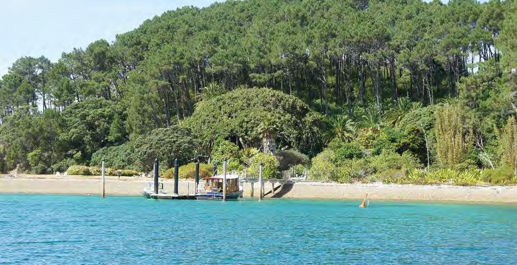
9 5.0 Visual Catchment and Viewing Audience 5.1 As mentioned previously, there is no public access to Waipohutukawa Bay and the surrounding coastline (i.e. Omarino development) by land. As a consequence, the viewing audience is restricted to marine craft users in the vicinity of Waipohutukawa Bay and people who land in the bay making use of public access rights up to MHWS. 5.2 The proposed jetty will not be visible from dwellings on the islands across the Te Rawhiti Inlet. As mentioned previously, the Omarino Resident s Group has given their written approval to the development. 6.0 Visual, Natural Character and Landscape Effects 6.1 As explained earlier, the visual effects methodology that has been applied in this assessment is attached in Appendix 1. Visual Effects 6.2 To assist an understanding of the visual effects of the development, U6 Photomontages Ltd have modelled the view from two vantage points on the water and the adjacent beaches as attached in Appendix 2 (together with a location plan and methodology statement). Viewpoint 1: View from the beach in front of the Collie property 6.3 Like the previous, this viewpoint relates to private marine craft that chose to land in the bay. The distinctly inhabited character of the western sub-bay means that it is reasonable to expect that the viewing audience is very limited. 6.4 The configuration of the jetty, gangway and pontoon to extend from the end of the rocky promontory lends a logic to the visual composition. 6.5 An awareness of the height of the boardwalk above the rock ledge and the scale of retaining that is required to enable safe access at HAT is appreciated from this orientation. The alignment of the boardwalk to hug the coast and therefore benefit from the filtering effect of lower hanging pohutukawa limbs will minimise the impression of the boardwalk as an isolated visual element. More importantly, the use of dark visually recessive materials (including the stained timber and natural stone) means that the boardwalk and path/retaining will merge with the mottled dark tones of the vegetation clad cliff backdrop. 6.6 The pontoons and piles will be seen against a water backdrop and will be relatively prominent in the outlook. That said, the use of dark coloured finish for each of these elements will ensure that they are not highly reflective. 6.7 Further, whilst the existing Collie dwelling is not visible in the photomontage, in views from the beach, the viewer can also see the large scale dwelling in the bay. This means that the proposed structures are seen within the wider visual context of a distinctly inhabited and modified bay which provides a contextual fit for the development. 6.8 On balancing these considerations, and in particular, factoring in the very limited viewing audience that is likely to be exposed to this outlook, adverse visual effects in relation to this audience are assessed as Low. Viewpoint 2: View from the beach in front of the Thornton property 6.9 The viewing audience afforded this outlook is limited to private marine craft that land in the Thornton sub- bay. Again, the distinctly inhabited nature of the sub-bay is such that it is reasonable to assume that this viewing audience is very limited The boardwalk/jetty and part of the gangway will be seen against a vegetation clad cliff backdrop. The use of a dark coloured finish for each of these elements will ensure that they are visually recessive The use of a natural stone edge to the retaining structure adjacent the path will ensure that this aspect of the development also blends with the backdrop The pontoons and piles will be seen against a water backdrop and will be relatively prominent in the outlook. That said, the use of dark coloured finish for each of these elements will ensure that they are not highly reflective Overall, the configuration of the jetty, gangway and pontoon to extend from the end of the rocky promontory lends a logic to visual composition Further, the very obvious visual connection and close proximity between the dwelling (and its private curtilage) and the proposed jetty that is available from this location will reinforce this visual logic and, as for the Collie beachfront, provides a contextual fit for the development In addition, the light coloured and prominent temporary pontoon that is visible throughout the summer months from the beachfront in this part of Waipohutukawa Bay will be removed as part of the proposed development On balancing these considerations, and in particular, factoring in the very limited viewing audience that is likely to be exposed to this outlook, adverse visual effects in relation to this audience are assessed as Low. Viewpoint 3: Closer range view from the water 6.17 In views from the water near the coastline (and within the larger embayment associated with Waipohutukawa Bay), the rocky promontory upon which the proposed jetty is to be located, reads as a natural break between the two sub-bays that make up Waipohutukawa Bay. The dwellings at the 18 March
10 Thornton property (to the left of view) and the Collie property (to the right of view) are clearly visible, with the dwelling at the Collie property forming a prominent element in the view Hints of the private access road are visible in places and together with ridgeline (maintenance) access tracks, these elements form the only disruption to the cloak of regenerating bush throughout the steep hillslopes backdropping the bay The sweep of sandy beach in front of each property in combination with the pohutukawa fringed rocky cliffs framing each beach and the bush clad backdrop unite to form a visually coherent outlook. However the scale of built development evident in the bay creates the impression of a distinctly modified and inhabited coastal landscape It should also be noted that this viewing location is only likely to be experienced by marine craft that deliberately choose to entire the wider embayment roughly defined by Tokatokahau Point (to the west) and Te Korowhiti to the east (- refer Figure 2) From this distance, the timber jetty and all of the gangway, pile and pontoon elements will be seen against the visually complex backdrop of the pohutukawa fringed rocky promontory in the centre of the bay. The landward elements of the development will be relatively visually indistinct from this orientation The development will introduce built modification into a portion of the bay that is currently undeveloped and reads as a break between the developed areas on either side The dark and visually recessive character of all visible built elements will ensure that they blend with the dark tones of the vegetation clad cliff backdrop and do not draw the eye in this view. In combination with the quite different and considerably more prominent visual character of the proposed development to the built development on either side, this will avoid the impression of development appearing to sprawl continuously throughout Waipohutukawa Bay The typically light colouration of boats tied up at the jetty are likely to draw visual attention to the structure, however this is a temporary effect and not an uncommon sight in the Bay of Islands coastal landscape where there are frequently moored vessels. I would also note that this is not an uncommon site in the eastern portion of the bay where vessels are frequently anchored off the beach or tied up at the temporary pontoon Whilst the temporary pontoon is not shown in the photomontage, this forms a prominent visual element in the view throughout the summer months. This element will be removed as part of the proposed development On balancing these considerations, adverse visual effects in relation to this audience are assessed as Low. Viewpoint 4: Longer range view from the water 6.27 The character of the outlook for viewers further out from the coast is similar to that described above with the exception that the reduced proximity of the viewer to land decreases the viewer s awareness of the scale and character of existing built development in each of the sub-bays resulting in a greater impression of visual coherence and a lessened awareness of the level of modification in each of the sub-bays. Balanced against this is a reduced appreciation of the visual complexity associated with the vegetation and rocky cliffs edging the coastline It is reasonable to assume that this viewpoint represents the distance from Waipohutukawa Bay of the majority of marine craft moving through this stretch of the Bay of Islands, as it corresponds to a path that is well clear of headlands and shallow waters The majority of the timber jetty and all of the gangway, pile and pontoon elements will be seen against the visually complex backdrop of the pohutukawa fringed rocky promontory in the centre of the bay. The landward elements of the development will be visually indistinct from this orientation The diminishing effects of distance will contribute an appreciable moderating effect. The dark, visually recessive character of all of the visible structures will minimise their reflectivity and ensure that they will be virtually indiscernible at this range The typically light colouration of boats tied up at the jetty are likely to draw visual attention to the structure, however this is a temporary effect and not an uncommon sight in the Bay of Islands coastal landscape At this distance the existing pontoon is expected to be relatively indistinct rendering its removal neutral in terms of visual effects On balancing these considerations, adverse visual effects in relation to this audience are assessed as Low- Negligible. Natural Character Effects 6.34 Key aspects of natural character include: the tidal waters of the bay; the relatively unobstructed sandy beach (excepting the temporary pontoon at the Thornton property); the pohutukawa fringed rocky promontory in the centre of the bay; the pohutukawa clad cliffs on either side of the bay; and, the almost continuous regenerating bush clad hillslopes behind the bay The proposed development will not disturb the pohutukawa clad cliffs on either side of the bay nor the regenerating bush clad hillslopes behind the bay Relying on the Arborist Assessment prepared by Peers Miller Brown, the effects of the development on the pohutukawas suggests that this aspect of natural character will not be adversely impacted The proposed development will however introduce built modification into a part of the rocky coastline that is currently devoid of structures The proposed construction method (timber piles) will ensure minimal disturbance to the rocky ledges However, the introduction of structures of the scale proposed will inevitably reduce the perceived naturalness (as opposed to biophysical naturalness) of a portion of Waipohutukawa Bay that is currently devoid of structures As demonstrated in the preceding visual assessment, the sympathetic siting and sensitive design of all structures will ensure that built development sits reasonably comfortably into the setting. The use of the sea floor mooring system is also sympathetic to these intentions, minimising the number of visible pile elements March
11 6.41 The way finding lighting will introduce lighting in an area that currently has a very low level of artificial lighting. The proposal to use way finding lighting only (i.e. with a low lux level), fixed to the landward facing toe kick, with a two way switch and timer will ensure that this aspect of the development is as discreet as possible Inevitably, the development will see boats sitting in the middle of the bay. These elements are typically light coloured and highly reflective, serving to increase the perception of development in the bay. However, as previously described, marine activities form an established component of the landscape character of the Bay of Islands and the eastern end of Waipohutukawa Bay (i.e. the temporary pontoon and frequently anchored boats at the Thornton property). For these reasons, vessels tied up at the proposed jetty will not appear as out of keeping with the wider coastal character Further, the clear visibility of built development throughout each sub-bay contributes an appreciable moderating effect with respect to natural character effects On balancing these considerations, adverse natural character effects are assessed to be Low. Landscape Effects 6.45 Generally, the proposed development seeks to minimise adverse landscape effects The sharing of a jetty between two properties avoids the potential need for two jetties in Waipohutukawa Bay Again, relying on the Arborist Assessment prepared by Peers Miller Brown, vegetation effects are assessed to be acceptable In an attractive coastal location of this nature, the location, form, scale, colour and des ign of all aspects of the development are of critical importance in determining whether the proposal generates adverse landscape effects As outlined in the preceding analysis, the location of the structure on a localised promontory (rather than on a beach or perpendicular to a long cliff line), the modest construction footprint, use of locally sourced stone, use of dark visually recessive materials, alignment of the boardwalk to hug the coast, sea floor mooring system, low key lighting and boardwalk design that sees the use of a toe kick rather than balustrading, are all critical design devices that have been employed to minimise the visual presence of the development within the bay. Overall, the proposal reflects the character of successfully integrated jetty development within the local area Further, the existing visible development at Waipohutukawa Bay provides an important context for the proposal in that it will read as part of the relatively typical water based facilities associated with many of the inhabited bays in the local area Overall, the visually recessive character of all built elements will ensure that the proposed development does not draw visual attention or detract from the 'sense of place' associated with Waipohutukawa Bay The absence of other jetties along this particular stretch of coastline (together with the proposal that the jetty is shared by two properties) will avoid the perception of a proliferation of jetties along this stretch of the south side of the Bay of Islands. Further, as outlined in the visual effects discussion, the recessive character and contrasting visual character of the proposal in comparison to the domestic development in each of the sub-bays will avoid the impression of development sprawling across the full extent of Waipohutukawa Bay As outlined in the previous discussion of natural character effects, the existing modified and built context of the bay provides an important moderating effect with respect to landscape effects, as does the consented temporary pontoon. Each of these existing developments suggest a tolerance for the relatively sympathetic change associated with the jetty proposal (and noting that the temporary pontoon will be removed as part of the proposal) On balancing these considerations, landscape effects are assessed to be Low. 7.0 Assessment against Relevant Statutory Criteria 7.1 With respect to the statutory documents of relevance to the subject site, objectives and policies germane to an assessment of visual, natural character and landscape effects focus on the following key themes: Natural Character the preservation of natural character and the avoidance of significant adverse effects on natural character; and, the avoidance of adverse effects on the characteristics and qualities that make the landscape outstanding. 7.2 The preceding discussion of natural character effects demonstrates that the proposal will not generate significant adverse natural character effects. 7.3 Whilst the development will modify a portion of the Waipohutukawa Bay coastline, it will occur within the immediate context of rural residential development and within a wider context in which scattered coastal structures are an established and accepted part of the coastal environment. 7.4 The location of the structure enables it to be used by two properties thereby avoiding the potential proliferation of such structures in this part of the Bay of Islands. The scale and from of the development is also consistent with successfully integrated jetty developments within the wider area. ONL 7.5 The ONL within which the site is located (Parekura Headland and Orokawa Peninsula) acknowledges the presence of built development in bays, describing it to be focused in embayments leaving the headlands and peninsulas free of development. I also note that the ONL mapping throughout the wider area coincides with a number of bays in which jetties are already evident, suggesting a certain tolerance for such structures in these high value landscapes. 20 March
12 7.6 The location of the jetty on the small rock promontory in the centre of Waipohutukawa Bay, rather than along the extensive rocks coastline and headlands to the west and eastern sides of the bay is considered to be sympathetic to this basic landscape patterning. 7.7 The occurrence of other similarly scaled jetty structures throughout the wider coastal landscape (including within ONLs) means that the proposal will not compromise the Representativeness values. The relatively discreet character of the development together with the moderate ranking (and therefore moderate sensitivity) of the area with respect to Rarity is such that these values will not be diminished. 7.8 The preceding discussion of visual effects demonstrates that the development will not detract from the Coherence, Diversity and Complexity and Vividness values of the area. Importantly the existing visual patterning and structure of sandy beaches interspersed with rocky headings and promontories will remain unchanged, as will the legibility of the rock ledges and simple cliff/beach interface. The use of loose locally sourced boulders to naturalise the retaining wall edges places an important role in this regard. 7.9 With respect to Naturalness and Intactness, the visually recessive character of the development will ensure that the landscape forms and patterns prevail and unify over that of development. The jetty itself will reinforce the connection between the land-based development and the sea, much in the way that other successfully integrated jetties throughout the Bay of Islands currently do. Further, it is noted that built development is acknowledged in the description of the ONL suggesting additional development of the scale and character proposed is unlikely to be incongruous The preceding discussion of visual and natural character effects reveals that the proposal will not detract from the Legibility of the landscape, as the underlying landscape structure and erosion processes that have shaped this portion of coastline will still be readable The visual fit of the proposal with other successfully integrated developments of this nature and scale, together with the rural residential context will ensure the Sensory Qualities of the area are not diminished. Rather the development will read as a well-integrated jetty facility typical of successfully integrated coastal structures already in place throughout the Bay of Islands Similarly, the moderate values of the area in terms of Shared and Recognised Values suggest a moderate sensitivity to change. As the ONL worksheet observes, the wider context of the southern side of the Bay of Islands is popular as a safe anchorage in bad weather. Within this associative context, the character and nature of the proposed development is considered to be in keeping Relying on the iwi consultation and the absence of identified archaeological sites in the immediate vicinity of the proposed development it is my understanding that adverse effects in relation to Spiritual, Cultural and Historical Associations will be negligible Overall, the proposed development will avoid adverse effects on the various characteristics and qualities for which the area is valued. 8.0 Conclusion 8.1 In conclusion, the carefully considered location, design and visually recessive character of all aspects of the built development, will ensure that the proposed development sits comfortably within this high value coastal landscape setting. 8.2 On balance, the proposal will give rise to adverse visual, natural character and landscape effects that are no more than minor. Further, the proposal is consistent with national and regional policy that seek to safeguard the visual amenity, natural character and landscape values of this portion of Bay of Islands coastline. Bridget Gilbert Landscape Architect B. Hort. Dip. L.A. ALI ANZILA (Registered) T M E bridget@bgla.nz 7.12 The proposal will not impact upon the water conditions component of the areas Transient Values. The carefully managed pruning of pohutukawa limbs (as required by the Arborist Report s recommendations) will ensure that the development does not adversely impact on the dramatic flowering display of pohutukawa in the area Whilst it is accepted that the area is reasonably remote and off the primary boating corridor, rural residential development and scattered jetties are clearly evident throughout this portion of the coastline. As such, the introduction of a sympathetically designed jetty will not disturb the sense of Remoteness and Wildness in this part of the Bay of Islands March
13 Appendix 1: Assessment of Landscape and Visual Effects General Landscape and visual impacts result from natural or induced change in the components, character, or quality of landscape. Usually these are the result of landform or vegetation modification or the introduction of new structures, activities, or facilities into the landscape. Landscape effects include effects on topographic, vegetative, and hydrological features. Landscape effects also refer to impacts on settlement patterns, historic and cultural features, and the general landscape character or sense of place of an area. Adverse impacts upon landscape values typically arise where discontinuity or discord is evident between what is proposed, and both the existing environment which provides its setting and the environment foreseeable in terms of the District Plan. In this instance, the main concerns in relation to any discontinuity or discord arise from the effects of the proposed development on the character of Waikopou Bay and this portion of the Waiheke coastline. Visual effects form a component of landscape effects. This assessment analyses the potential visual effects that may be generated by the proposal and is based on: the background and context within which the development would be viewed; the proportion of the built form (including earthworks) that will be visible, determined by the observer s position relative to the objects being viewed; the number and type of viewers and their location in relation to the site; and the ability to integrate structures and activities with mitigation planting. Visual effects are ranked as follows: Negligible corresponds to a situation where the proposed development is barely discernible with respect to effects in relation to existing visual landscape or outlook. Effects in relation to landscape (and natural character) values are rated as follows: Very High corresponds to a situation where the proposed development will significantly (negatively) change the character or quality of the existing landscape (or natural character) values of the site and/or the surrounding area; High corresponds to a situation where the proposed development will generate a high adverse effect on the character or quality of the existing landscape (or natural character) values of the site and/or surrounding area, with the scale of adverse effect considered to extend above the normal level, or be great in amount, value, size or intensity ; Moderate corresponds to a situation where the proposed development will comprise an adverse effect on the character or quality of the existing landscape(or natural character) values of the site and/or the surrounding area, with the scale of adverse effect considered to be average in amount, intensity or degree ; Low corresponds to a situation where the proposed development is unlikely to comprise an adverse effect on the character or quality of the existing landscape (or natural character) values of the site and/or the surrounding area, with the scale of adverse effect considered to be below average in amount, extent or intensity ; and, Negligible corresponds to a situation where the proposed development is barely discernible with respect to effects in relation to landscape (or natural character) values of the site and/or the surrounding area. Very High corresponds to a situation where the proposed development will significantly (negatively) change the character or quality of the existing visual landscape or outlook; High corresponds to a situation where the proposed development will generate a high adverse effect on the character or quality of the existing visual landscape or outlook, with the scale of adverse effect considered to extend above the normal level, or be great in amount, value, size or intensity ; Moderate corresponds to a situation where the proposed development will comprise an adverse effect on the character or quality of the existing visual landscape or outlook, with the scale of adverse effect considered to be average in amount, intensity or degree ; Low corresponds to a situation where the proposed development is unlikely to comprise an adverse effect on the character or quality of the existing visual landscape or outlook, with the scale of adverse effect considered to be below average in amount, extent or intensity ; and, For the purposes of evaluating the need for notification, it is generally regarded that adverse effects rated as Moderate or higher correspond to a more than minor effect. Effects rated as Moderate Low and Low correspond to a minor effect and effects rated as Negligible correspond to a less than minor effect. 22 March
14 Appendix 2: Photomontages March
: 349836.70 me / 980659.")

: 2.18 m Camera: Canon EOS 5D Mark III FFDSLR 24.")
: 349834.60 me / 980957.")

15 Photo Viewpoint 1 Shooting date: 07 April :33 p.m Viewpoint camera location (Geodetiv Datum 2000, Mt Eden Circuit): me / mn Camera elevation (One tree point MSL Datum): 1.48 m Camera: Canon EOS 5D Mark III FFDSLR 24.0mm focal length PREPARED BY U6 PHOTOMONTAGES LIMITED Photo Viewpoint 2 Shooting date: 07 April :01 p.m Viewpoint camera location (Geodetiv Datum 2000, Mt Eden Circuit): me / mn Camera elevation (One tree point MSL Datum): 2.18 m Camera: Canon EOS 5D Mark III FFDSLR 24.0mm focal length Photo Viewpoint 3 Shooting date: 07 April :21 p.m Viewpoint camera location (Geodetiv Datum 2000, Mt Eden Circuit): me / mn Camera elevation (One tree point MSL Datum): 1.46 m Camera: Canon EOS 5D Mark III FFDSLR 24.0mm focal length Photo Viewpoint 4 Shooting date: 07 April :24 p.m Viewpoint camera location (Geodetiv Datum 2000, Mt Eden Circuit): me / mn Camera elevation (One tree point MSL Datum): 1.41 m Camera: Canon EOS 5D Mark III FFDSLR 24.0mm focal length Camera location maps WAIPOHUTUKAWA BAY JETTY PHOTOMONTAGE VIEWPOINT LOCATIONS AND IMAGE DATA Scale: NTS Resource Consent Issue Date of issue: 07 September 2017
16 PREPARED BY U6 PHOTOMONTAGES LIMITED EXISTING SITUATION PHOTOMONTAGE OF THE PROPOSED WAIPOHUTUKAWA BAY JETTY PHOTOMONTAGE 2 Photo viewpoint 2 Orientation of view (N=0 o, E=90 o): 270 o West Horizontal field of view: 74 degrees / Vertical field of view: 27 degrees Scale: The correct reading distance is 260mm (when this document is reproduced at A3) Resource Consent Issue Date of issue: 07 September 2017 PRINTING: THIS DOCUMENT SHOULD BE PRINTED ON A3 SIZE PAPER SCALED AT 1:1 (100%). DO NOT USE PRINT OPTIONS FIT TO PAPER OR SHRINK TO PRINTABLE AREA
 Resource Consent")
17 PREPARED BY U6 PHOTOMONTAGES LIMITED EXISTING SITUATION PHOTOMONTAGE OF THE PROPOSED WAIPOHUTUKAWA BAY JETTY PHOTOMONTAGE 3 Photo viewpoint 3 Orientation of view (N=0 o, E=90 o): o South-southeast Horizontal field of view: 74 degrees / Vertical field of view: 27 degrees Scale: The correct reading distance is 260mm (when this document is reproduced at A3) Resource Consent Issue Date of issue: 07 September 2017 PRINTING: THIS DOCUMENT SHOULD BE PRINTED ON A3 SIZE PAPER SCALED AT 1:1 (100%). DO NOT USE PRINT OPTIONS FIT TO PAPER OR SHRINK TO PRINTABLE AREA
Assessment of Landscape, Visual and Natural Character Effects
 Assessment of Landscape, Visual and Natural Character Effects Consent Footprint Amendments Mangamaunu Half Moon Bay Okiwi Bay South Report prepared for: New Zealand Transport Agency and KiwiRail Holdings
Section 6A 6A Purpose of the Natural Features and Landscapes Provisions
 Section 6A 6A Purpose of the Natural Features and Landscapes Provisions This Chapter addresses the protection and management of natural features and landscapes within the City. The City has a number of
Apply scoring methodology
 1 Assessment of Alternatives The purpose of this assessment is to evaluate runway options against a range of environmental criteria. The first step is to formulate evaluation criteria necessary to understand
LANDSCAPE GUIDELINES. Countryside & Coastal Countryside Environments. Landscape, Natural Character & Amenity Values Guide
 Landscape, Natural Character & Amenity Values Guide Copyright WDC 2009 Version A2 18May09 Environmental Services Group Publication Countryside & Coastal Countryside Environments START HERE Quality Land
CA.1 Coastal Area. Index. CA.1.1 Description and Expectations
 Index.1.2.3.4 CA.2 CA.2.1 CA.2.2 CA.2.3 CA.3 CA.3.1 CA.3.2 CA.3.1 CA.4 CA.4.1 CA.4.2 CA.4.3 CA.4.4 CA.5 CA.5.1 CA.5.2 Description and Expectations Objectives Policies Guidance Note Landuse Eligibility
Northland Regional Landscape Assessment Worksheet
 Northland Regional Landscape Assessment Worksheet Unit name TE POUAHI HEADLAND DESCRIPTION AND CHARACTERISATION Component Land Types (refer to list overleaf) Dune complex Coastal cliffs / escarpment Reefs
Chapter 3: Natural Environment. Proposed Waikato District Plan Stage 1. (Notified version)
") Chapter 3: Natural Environment Proposed Waikato District Plan Stage 1 Page 2 of 7 Contents Chapter 3: Natural Environment... 3 3.1 Indigenous Vegetation and Habitats... 3 3.1.1 Objective Biodiversity and
Chapter 3: Natural Environment Proposed Waikato District Plan Stage 1 Page 2 of 7 Contents Chapter 3: Natural Environment... 3 3.1 Indigenous Vegetation and Habitats... 3 3.1.1 Objective Biodiversity and
Northland Regional Landscape Assessment Worksheet
 Northland Regional Landscape Assessment Worksheet DESCRIPTION AND CHARACTERISATION Component Land Types (refer to list overleaf) Volcanic cones Geology (including geopreservation sites) Soil Types Unit
3. Highway Landscaping Assessment
 Guidelines for Highway Landscaping 3-1 3. Highway Landscaping Assessment 3.1 Introduction This section outlines the steps necessary to assess the highway landscaping component of a state highway construction
Northland Regional Landscape Assessment Worksheet
 Northland Regional Landscape Assessment Worksheet DESCRIPTION AND CHARACTERISATION Component Land Types (refer to list overleaf) Coastal cliffs / escarpment Bays and headlands Dune complex Beach Reefs
Raewyn Peart. Policy Director Environmental Defence Society
 1 Raewyn Peart Policy Director Environmental Defence Society www.eds.org.nz Coastal Environment Where the sea impacts on the land and the land impacts on the sea 2 www.eds.org.nz Section 6 RMA matters
LANDSCAPE UNIT 10 Te Kawau, Turipeka & Otautu Point
 Location Map LANDSCAPE VALUES Landscape Unit No. 10 Description: Te Kawau, Turipeka, & Otautu Point KEY LANDSCAPE FACTORS / VARIABLES LANDSCAPE UNIT 10 Te Kawau, Turipeka & Otautu Point LEGEND Outstanding
Northland Regional Landscape Assessment Worksheet
 Northland Regional Landscape Assessment Worksheet DESCRIPTION AND CHARACTERISATION Component Land Types Northern and eastern dissected hills; moderate to high relief land type Unit name NORTH EAST BUSH
B4. Te tiaki taonga tuku iho - Natural heritage
 B4. Te tiaki taonga tuku iho - Natural heritage Tuia I runga, tuia i raro, tuia ki te waonui a Tiriwa Bind the life forces of heaven and earth to the great realm of Tiriwa B4.1. Issues Auckland s distinctive
Evidence-based Assessment of Natural Character
 Evidence-based Assessment of Natural Character RMLA Waikato Branch 07 Sept 2016 Michael Steven Landscape Architect/Landscape Planner Pohara, Golden Bay 1 The key issue. The adequacy of landscape & natural
D10. Outstanding Natural Features Overlay and Outstanding Natural Landscapes Overlay
 D10. Outstanding Natural Features Overlay and Outstanding Natural Landscapes Overlay D10.1. Background These provisions give effect to Policy 15(a) of the New Zealand Coastal Policy Statement 2010, and
6 Landsc apes and rur al char ac
 LANDSCAPES AND RURAL CHARACTER QLDC PROPOSED DISTRICT PLAN [PART TWO] DECISION VERSION ter 6 Landsc apes and rur al char ac 6.1 Purpose Appendix C QLDC DISTRICT PLAN [PART TWO] DECISION VERSION 6 Landsc
D10. Outstanding Natural Features Overlay and Outstanding Natural Landscapes Overlay
 D10. Outstanding Natural Features Overlay and Outstanding Natural Landscapes Overlay D10.1. Background These provisions give effect to Policy 15(a) of the New Zealand Coastal Policy Statement 2010, and
Visual Effects Assessment Hapimana Street, Ōrākei. Prepared for Ngāti Whātua Ōrākei
 Xanthe White Design Ltd Studio 29, Level 2, St Kevin s Arcade, 179 Karangahape Rd PO Box 68658, Wellesley Street, Auckland 1141 (09) 300 7135 www.xwd.co.nz Visual Effects Assessment Hapimana Street, Ōrākei
3.1 This evidence is based on the landscape and visual impact assessment included in Chapter 10 and Appendix I of the EIS.
 LANDSCAPE & VISUAL 1 QUALIFICATIONS AND EXPERIENCE 1.1 My name is Raymond Holbeach and I am a Regional Director for RPS Planning & Environment with full responsibility for management of the RPS Belfast
SH1 - Causeway, Auckland, 2014 (Source: NZ Transport Agency)
") SH1 - Causeway, Auckland, 2014 (Source: NZ Transport Agency) Coastal effects assessment guide Environmental and social responsibility policy State highway environmental plan Transport Agency statement
SH1 - Causeway, Auckland, 2014 (Source: NZ Transport Agency) Coastal effects assessment guide Environmental and social responsibility policy State highway environmental plan Transport Agency statement
Appendix One. Landscape. Areas of Outstanding Landscape Value: Criteria for Selection. Landscape Character
 Areas of Outstanding Value: Criteria for Selection The dimensions of landscape are landscape character and landscape quality. The analysis of landscape character and quality draws heavily on the visual
Proposed Southland District Plan 2012 Appeal Version October 2016
 S e c t i o n 3. 5 - F i o r d l a n d / R a k i u r a Z o n e The Fiordland/Rakiura Zone encompasses the Fiordland and Rakiura National Parks and part of Mt Aspiring National Park. It also includes areas
I615. Westgate Precinct
 I615. Westgate Precinct I615.1. Precinct Description The Westgate Precinct is located approximately 18km west of the Auckland city centre. There are seven Sub-precincts in the Westgate Precinct: Sub-precinct
Section 32 report: Natural heritage for the Proposed Natural Resources Plan for the Wellington Region
 Section 32 report: Natural heritage for the Proposed Natural Resources Plan for the Wellington Region Issues and Evaluation Report Section 32 report: Natural heritage for the Proposed Natural Resources
Tāhuhu whakaruruhau ā-taone The sheltering ridge pole
 B2. Tāhuhu whakaruruhau ā-taone - Urban growth and form B2.1. Issues Tāhuhu whakaruruhau ā-taone The sheltering ridge pole Auckland s growing population increases demand for housing, employment, business,
Plan Modification to Chapter B2 of the Auckland Unitary Plan(AUP) Operative in part (15 November 2016)
 Operative in part (15 November 2016)") UNITARY PLAN UPDATE REQUEST MEMORANDUM TO FROM Phill Reid Linley Wilkinson DATE 25 September 2018 SUBJECT Plan Modification to Chapter B2 of the Auckland Unitary Plan(AUP) Operative in part (15 November
UNITARY PLAN UPDATE REQUEST MEMORANDUM TO FROM Phill Reid Linley Wilkinson DATE 25 September 2018 SUBJECT Plan Modification to Chapter B2 of the Auckland Unitary Plan(AUP) Operative in part (15 November
4 RESIDENTIAL ZONE. 4.1 Background
 4 RESIDENTIAL ZONE 4.1 Background The residential areas within the City are characterised by mainly lowrise dwellings sited on individual allotments. Past architectural styles, settlement patterns and
7. Landscape. Introduction
 Introduction Our landscapes provide us with a Marlborough identity and are an integral part of the Marlborough environment. Landscapes are distinct spatial areas influenced by location-specific processes
1 INTRODUCTION TO NATURAL ENVIRONMENT
 Kāpiti Coast District Plan Review Section 32 Analysis Summary Report 1 INTRODUCTION TO NATURAL ENVIRONMENT Diverse landscapes, plants and animals make up the natural environment of the District. Much has
Tables of Criteria and Matrices for Landscape Assessment (LSCA & LVIA)
") Carly Tinkler CMLI Environmental, Landscape and Colour Consultancy 46 Jamaica Road, Malvern, Worcestershire WR14 1TU Tel +44 (0)7711 538854 carlytinkler@hotmail.co.uk Tables of Criteria and Matrices for
Carly Tinkler CMLI Environmental, Landscape and Colour Consultancy 46 Jamaica Road, Malvern, Worcestershire WR14 1TU Tel +44 (0)7711 538854 carlytinkler@hotmail.co.uk Tables of Criteria and Matrices for
STATEMENT OF OBJECTION TO THE PROPOSED DEVELOPMENT OF LAND AT CHURCH CLIFF DRIVE FILEY
 STATEMENT OF OBJECTION TO THE PROPOSED DEVELOPMENT OF LAND AT CHURCH CLIFF DRIVE FILEY You will be aware that Scarborough borough council have adopted a new local plan that includes land at Church Cliff
Introduction. Regional Context
 Introduction The applicant seeks consent to subdivide Lot 3 422974, a 9.07 ha lot, into two lots, Lot 1 being 0.58ha and the balance, Lot 2 of 8.5ha. As shown on attached plan prepared by Dunwoodie & Green
Milford Shopping Centre Proposed Plan Change Assessment of Visual and Landscape Effects
 Milford Shopping Centre Proposed Plan Change Assessment of Visual and Landscape Effects LA4 Landscape Architects PO Box 5669, Wellesley Street Auckland Table of Contents 1.0 Introduction 3 2.0 The Proposed
I602. Birdwood Precinct
 I602. Birdwood Precinct I602.1. Precinct description The Birdwood Precinct applies to an area west of Don Buck Road and south of Red Hills Road in west Auckland. It incorporates subdivision and development
I539. Smales 2 Precinct
 I539. Smales 2 Precinct I539.1. Precinct Description The Smales 2 Precinct applies to a 4.8 hectare block of land located on the southern side of Northcote Road and fronting Lake Pupuke, Takapuna. The
E15. Vegetation management and biodiversity
 E15. management and biodiversity E15.1. Background contributes to a range of ecosystem services such as erosion and sediment control, reducing stormwater flows, protecting or enhancing water quality, amenity
ROAD AND CAR PARK DESIGN GUIDELINES
 3.2 ROAD AND CAR PARK DESIGN GUIDELINES PIHA AREA DESIGN GUIDELINES AUCKLAND REGIONAL COUNCIL 37 Existing Road and Car Park Photos: North Piha carpark Anawhata carpark Winstone Track carpark off Piha Road
open space environment
 This section updated August 09 GUIDELINE TO THE RULES The Open Space Environment Rules apply to activities on sites within the Open Space Environment as shown on the Human Environments Maps. Most of the
Visual Impact Assessment - December Figure 5.2: Viewshed analysis of the haul route.
 Visual Assessment - December 2014 Figure 5.2: Viewshed analysis of the haul route. 21 Baobab Resources (Pty) Ltd 5.1.3 Visual Exposure The following can be deduced from the Figure 5.1: the area to the
Part 3 : : Outstanding Natural Features and Landscapes
 Part 3 : : Outstanding Natural Features and Landscapes Review and Evaluation of Outstanding Natural Features and Landscapes tauranga city : : landscape study 157 Introduction Introduction Tauranga City
Garden Bridge Planning Application
 Planning Application Additional Verified photomontages and assessment September 2014 Contents Page 1 Visual assessment 2 1.1 Introduction 2 1.2 Baseline 2 1.3 Potential effects and good environmental
PART 5 - NATURAL AND PHYSICAL ENVIRONMENT
 CONTENTS...PAGE 5.1 INTRODUCTION...3 5.2 NATURAL RESOURCES...4 5.3 PHYSICAL RESOURCES...4 5.4 COASTAL ENVIRONMENT...4 5.5 HERITAGE FEATURES...4 5.6 HAZARDS...4 5.7 SUMMARY...4 ISTHMUS SECTION - OPERATIVE
Chapter 7: Landscape and Visual Impact Assessment
 Chapter 7: Landscape and Visual Impact Assessment Landscape Character and Visual Impact Assessment 7. Landscape Character and Visual Impact Assessment... 2 7.1 Methodology... 2 7.2 Assessment Findings...
PART 05 VISUAL SETTING
 PART 05 VISUAL SETTING 5.1 How to use the Visual Settings 5.2 Views from the Headland 5.3 Creek Foreshore Park Looking North 5.4 Bridge looking North 5.5 Bridge looking West 5.6 Bridge looking South 5.7
WELLINGTON CITY DISTRICT PLAN
 Section 32 Report WELLINGTON CITY DISTRICT PLAN PROPOSED DISTRICT PLAN CHANGE 54 REZONING 178 AND 180 OWHIRO BAY PARADE 1 Introduction Before a Proposed District Plan change is publicly notified the Council
I511. Hatfields Precinct
 I511. Hatfields Precinct I511.1. Precinct Description The Hatfields Precinct is a contiguous 183.8 hectare block of rural land held in 8 freehold titles, located immediately to the north of Hatfields Beach.
Northland Regional Landscape Assessment Worksheet
 Northland Regional Landscape Assessment Worksheet Unit name BALD ROCK DESCRIPTION AND CHARACTERISATION Component Land Types (refer to list overleaf) Volcanic cone (remains). Comment The site is an eye-catching
15.0 EFFECT ON THE ENVIRONMENT: Sunlight
 15.0 EFFECT ON THE ENVIRONMENT: Sunlight 15.1 Introduction 15.1.1 ARC Architectural Consultants Ltd has been retained to carry out an analysis of the shadows likely to be cast by the proposed structures
North York Moors National Park Authority Planning Committee
 Item 8 North York Moors National Park Authority Planning Committee 12 December 2013 Consultation from Redcar and Cleveland Borough Council on proposed Wind Farm at Bank Field Guisborough 1. Purpose of
SECTION ONE North East Industrial Zone Design Guide Palmerston North City Council June 2004
 SECTION ONE North East Industrial Zone Design Guide Palmerston North City Council June 2004 young heart easy living 1 Preface Industrial areas are a very important component of the economic well-being
C Landscape and Visual Effects Assessment
 C Landscape and Visual Effects Assessment Hawkes Bay Office: PO Box 8823 Havelock North Hawke's Bay 4157 www.hudsonassociates.co.nz john@hudsonassociates.co.nz Ph 06 877-9808 HUDSON ASSOCIATES M 021 324-409
SECTION 2.4 URBAN DEVELOPMENT AND STRATEGIC URBAN DIRECTIONS
 SECTION 2.4 URBAN DEVELOPMENT AND STRATEGIC URBAN DIRECTIONS 2.4.1 INTRODUCTION In 1993/94 the Hastings District Council completed the Hastings Urban Development Strategy. The purpose of this study was:
Proposed Plan Change 55: District Wide Rules. Hearing Report
 Proposed Plan Change 55: District Wide Rules Hearing Report Appendix 5 BEFORE THE HEARINGS PANEL In the Matter of: The Resource Management Act 1991 And Proposed Plan Change 55: Chapter 3 District Wide
PART II APPENDIX 3: COASTAL TASMAN AREA SUBDIVISION AND DEVELOPMENT DESIGN GUIDE
 Operative Part II, Appendix 3 Coastal Tasman Area Subdivision and Development Design Guide 26 September 2009 PART II APPENDIX 3: COASTAL TASMAN AREA SUBDIVISION AND DEVELOPMENT DESIGN GUIDE CHAPTER 1 -
SUSTAINABLE MANAGEMENT
 . Sustainable Management.1 The Concept of Sustainable Management The concept of sustainable management recognises there are limits to the use of natural and physical resources and there is a need to balance
AOTEA SUPERMARKET ZONE. Zone Introduction
 C18 AOTEA SUPERMARKET ZONE Zone Introduction C18.1 Objective This zone identifies a specific area in Aotea for a stand alone supermarket. The zone is site specific and has a range of objectives, policies
2.1 Decision Making Matrix
 2.1 Decision Making Matrix The following decision-making matrix merges the elements of architectural and historical significance and current condition within the over-arching treatment recommendation of
Northland Regional Landscape Assessment Worksheet
 Northland Regional Landscape Assessment Worksheet Unit name KAURI MOUNTAIN BUSH DESCRIPTION AND CHARACTERISATION Component Land Types Volcanic cones land type Northern and eastern dissected hills; moderate
Section 3b: Objectives and Policies Rural Environment Updated 19 November 2010
 Page 1 of Section 3b 3b RURAL ENVIRONMENT 3b.1 Introduction The Rural Environment comprises all the land outside of the Residential, Town Centre and Industrial Environments. Most land within the District
Appendix A. Planning Processes. Introduction
 1 Planning Processes Introduction This appendix outlines a number of planning processes which are used in the Auckland Region to support the effective management of development in the region s rural and
4 Residential and Urban Living Zones
 4 Residential and Urban Living Zones Refer to Chapters 11 to 20 for additional rules that may apply to these zones. 4.1 OBJECTIVES AND POLICIES Objective Res1 Policy 1 Policy 2 Policy 3 Policy 4 Policy
I505. Chelsea Precinct
 I505. Chelsea Precinct I505.1. Precinct Description This precinct covers land and water areas owned and/or formerly used by the Chelsea Sugar Refinery at Birkenhead. Chelsea Estate Heritage Park is owned
I611. Swanson North Precinct
 I611. Swanson North Precinct I611.1. Precinct Description Swanson North is located in the north eastern foothills of the Waitakere Ranges. It is outside the Waitakere Ranges Heritage Area Act and the Waitakere
Assessment of Landscape and Visual Effects Project Beachside Mission Bay Drive Holdings Limited Mission Bay Auckland
 Assessment of Landscape and Visual Effects Project Beachside Mission Bay Drive Holdings Limited Mission Bay Auckland LA4 Landscape Architects PO Box 5669, Wellesley Street Auckland City Assessment of Landscape
Request for further information response Landscape
 Request for further information response Landscape CRC 156320 Prepared with regard to a land use resource consent application to increase irrigation areas Prepared for Benmore Irrigation Company Limited
I541. Te Arai North Precinct
 I541. Te Arai North Precinct I541.1. Precinct Description The Te Arai North Precinct contains approximately 616ha of coastal land north of Te Arai Point, generally known as Mangawhai North Forest. The
LANDSCAPE AND VISUAL IMPACT ASSESSMENT
 HARE STREET ROAD BUNTINGFORD LANDSCAPE AND VISUAL IMPACT ASSESSMENT Prepared by ACD Chartered Landscape Architects for Written By: SJD Checked By: JS Date: Document File Ref: TWNT18550lvia Revision: A-
INCREMENTAL CHANGE AREA REVIEW March 2015 Page 1
 INCREMENTAL CHANGE AREA REVIEW March 2015 Page 1 Table of Contents Introduction... 3 Background to Review... 3 Comparison of the Schedules to the General Residential Zone... 7 Methodology... 7 Policy Context...
Appendix 1 Structure plan guidelines
 Appendix 1 Structure plan guidelines This appendix forms part of the regional policy statement [rps]. 1.1. Introduction Structure plans are an important method for establishing the pattern of land use
4.3 Dudley Area Plan. Introduction. History and Existing Character. Desired Future Character for Dudley
 4.3 Dudley Area Plan Introduction The suburb of Dudley has developed as a result of various circumstances including its topography, history and mineral resources. Dudley development has been identified
Visual Impact Rating Form - Instructions
 Visual Impact Rating Form Instructions Project Name: Baron Winds Project EDR Project No: 13039 Date: 05.16.17 Reference: Visual Impact Rating Form - Instructions These instructions are intended to guide
REMARKABLES PARK ZONE
 .10 Remarkables Park Zone.10.1 Resources, Activities and Values The Remarkables Park Area comprises approximately 150 hectares of perimeter urban land in the vicinity of Frankton and occupies a strategic
Lake Macquarie Scenic Management Guidelines 2013
 Lake Macquarie Scenic Management Guidelines 2013 TABLE OF CONTENTS: PART A: INTRODUCTION...9 1 INTRODUCTION...9 1.1 Purpose of this document...9 1.2 What are scenic and landscape values?...9 1.3 Why do
H7 Open Space zones. (a) provide for the needs of the wider community as well as the needs of the community in which they are located;
 provide for the needs of the wider community as well as the needs of the community in which they are located;") H7. Open Space zones H7.1. Background The majority of land zoned as open space is vested in the Council or is owned by the Crown. However some areas zoned open space are privately owned. While the open
H7. Open Space zones H7.1. Background The majority of land zoned as open space is vested in the Council or is owned by the Crown. However some areas zoned open space are privately owned. While the open
RURAL ZONE - POLICY. Rural Zone Policy. Issue: Rural Environment. Ruapehu District Plan Page 1 of 8
 Rural Zone Policy RU2 RURAL ZONE - POLICY RU2.1 Introduction The natural resources of the rural environment in the Ruapehu District provide the basis for the existing and potential character, intensity
Lower Sensitivity. VS Classification Level 2: Exposed Upland/Plateau
 S02 Y Carneddau Reproduced from the Ordnance Survey map with the permission of Ordnance Survey on behalf of the Controller of Her Majesty s Stationery Office, Crown copyright Licence No. 100023387 Location
REPORT. Thames Coromandel District Council. Buffalo Beach Trial Groyne. Resource Consent Application and Assessment of Effects on the Environment
 REPORT Resource Consent Application and Assessment of Effects on the Environment Report prepared for: Report prepared by: Tonkin & Taylor Ltd Distribution: Tonkin & Taylor Ltd (FILE) Waikato Regional Council
I542. Te Arai South Precinct
 I542. Te Arai South Precinct I542.1. Precinct Description The Te Arai South Precinct contains approximately 750ha of coastal land south of Te Arai Point, known as Mangawhai South Forest. The land within
Visualisations for aquaculture
 Scottish Natural Heritage Visualisations for aquaculture Draft Guidance Note draft 1 Contents Section 1 1 Summary of recommendations 1 Section 2 4 Introduction 4 Landscape and Visual Impact Assessment
Cardiff International Sports Village Waterfront Development Volume IV : Non-Technical Summary of the Environmental Statement
 Greenbank Partnerships Ltd October 2012 Cardiff International Sports Village Waterfront Development Volume IV : Non-Technical Summary of the Environmental Statement Environmental Statement - Non Technical
17A. Wind Microclimate
 17A. Wind Microclimate 17A.1 Introduction 17A.1.1 17A.1.2 17A.1.3 17A.1.4 This Chapter, which has been prepared by Waterman and BMT, provides further information with regard to the potential wind microclimate
Grantham Southern Quadrant Link Road Environmental Statement
 Grantham Southern Quadrant Link Road Environmental Statement Non Technical Summary Introduction Lincolnshire County Council (LCC) is submitting a planning application for the proposed implementation of
Development in the setting of the Cotswolds AONB
 COTSWOLDS CONSERVATION BOARD POSITION STATEMENT Development in the setting of the Cotswolds AONB.1. Introduction Areas of Outstanding Natural Beauty (AONBs) are designated by the Government for the purpose
I209 Quay Park Precinct
 I209. Quay Park I209.1. Precinct description The Quay Park Precinct is located on reclaimed land at the eastern end of the city centre and along the City Centre waterfront. It is dissected to the east
GUILDFORD BOROUGH GREEN BELT AND COUNTRYSIDE STUDY
 GUILDFORD BOROUGH GREEN BELT AND COUNTRYSIDE STUDY Volume II - Addendum On behalf of Guildford Borough Council PPG Ref : BNL.0287 April 2014 COPYRIGHT The conents of this document must not be copied or
14 LANDSCAPE AND VISUAL IMPACT ASSESSMENT
 Indaver Carranstown Landscape and Visual Impact Assessment 14 LANDSCAPE AND VISUAL IMPACT ASSESSMENT 14.1 INTRODUCTION ARC Consultants have been commissioned by the Applicant to carry out a visual impact
22.15 OUTDOOR ADVERTISING SIGNAGE POLICY
 22.15 OUTDOOR ADVERTISING SIGNAGE POLICY This policy applies to all land where a planning permit is required to construct or display a sign under the provisions of the Kingston Planning Scheme. 22.15-1
Digital Terrestrial Television Infrastructure Rollout. Environmental Impact Assessment - Corridor -
 Digital Terrestrial Television Infrastructure Rollout Environmental Impact Assessment - Corridor - 1 1 ENVIRONMENTAL IMPACT ASSESSMENT (EIA): CORRIDOR 1.1 INTRODUCTION Corridor is a small farming community
9.1 ISSUES OBJECTIVES RULES - Class B - Heritage Items RULES - Class C - Heritage Items RULES - Old Town Overlay Area 18
 9 HISTORIC HERITAGE 9.1 ISSUES 7 9.2 OBJECTIVES 7 9.3 POLICIES 8 9.4 RULES - Class A - Heritage Items 13 9.5 RULES - Class B - Heritage Items 15 9.6 RULES - Class C - Heritage Items 17 9.7 RULES - Old
METHODOLOGY FOR IMPACT ASSESSMENT ON HERITAGE ASSETS IDENTIFICATION OF THE RECEPTOR ASSESSMENT OF THE RECEPTOR S IMPORTANCE
 METHODOLOGY FOR IMPACT ASSESSMENT ON HERITAGE ASSETS The determination of impacts on heritage assets follows the standard procedures applied to all Environmental Impact Assessment. This entails the identification
COROMANDEL PENINSULA LANDSCAPE ASSESSMENT. PREPARED FOR Thames Coromandel District Council DATE September STATUS Draft
 PREPARED FOR Thames Coromandel District Council DATE September 2011. STATUS Draft STATUS DRAFT. SCALE as shown @ A3. DATE September 2011. PAGE 2 INTRODUCTION OUTSTANDING & AMENITY LANDSCAPES Coromandel
Views from the Bridge
 Chapter 2 Views from the Bridge Alternative 2A would primarily have adverse visual impacts to views from the Bridge, with the exception of a strongly adverse visual impact from Viewpoint 11 (Car View East)
Before the Environment Court at Auckland ENV-2013-AKL
 Before the Environment Court at Auckland ENV-2013-AKL-000174 In the Matter of the Resource Management Act 1991 And In the Matter of Notice of Motion under Section 87G requesting the granting of resource
The Proposed Auckland Unitary Plan (notified 30 September 2013)
") 3 Business zones Introduction There are 10 business zones in the Unitary Plan: City Centre Metropolitan Centre Town Centre Local Centre Neighbourhood Centre Mixed Use General Business Business Park Light
3 Business zones Introduction There are 10 business zones in the Unitary Plan: City Centre Metropolitan Centre Town Centre Local Centre Neighbourhood Centre Mixed Use General Business Business Park Light
AND STATEMENT OF EVIDENCE OF ROBERT JAMES PRYOR
 IN THE MATTER of the Resource Management Act 1991 AND IN THE MATTER of applications by CYPRESS CAPITAL LTD to the TAUPO DISTRCT COUNCIL to authorise construction and use of a hotel development at 29 Tuwharetoa
Suffolk Coastal Local Plan Review Issues and Options, August 2017, Public Consultation
 Suffolk Coastal Local Plan Review Issues and Options, August 2017, Public Consultation Having reviewed the issues and options documents, the Society has made the following response: Part 1 - Strategic
6.3 VISUAL RESOURCES. Landscape Character
 6.3 VISUAL RESOURCES 6.3.1 Affected Environment The DMR discussion is divided into two areas, DMR and Dillingham Trail, which would extend from SBMR to DMR. The ROI includes all areas within the line of
Section 32 Report Part 2. Landscape & Natural Character. Proposed Waikato District Plan
 Section 32 Report Part 2 Landscape & Natural Character prepared for the Proposed Waikato District Plan July 2018 2 TABLE OF CONTENTS 1 OVERVIEW AND PURPOSE...4 1.1 Topic Description...4 1.2 Significance
GIBBSTON CHARACTER ZONE. QLDC PROPOSED DISTRICT PLAN [PART FOUR] AUGUST gibbston character zone
![GIBBSTON CHARACTER ZONE. QLDC PROPOSED DISTRICT PLAN [PART FOUR] AUGUST gibbston character zone](/thumbs/75/72573993.jpg "GIBBSTON CHARACTER ZONE. QLDC PROPOSED DISTRICT PLAN [PART FOUR] AUGUST gibbston character zone") 23 GIBBSTON CHARACTER ZONE QLDC PROPOSED DISTRICT PLAN [PART FOUR] AUGUST 2015 23 gibbston character zone QLDC PROPOSED DISTRICT PLAN [PART FOUR] AUGUST 2015 23 gibbston character zone 23.1 Zone Purpose
23 GIBBSTON CHARACTER ZONE QLDC PROPOSED DISTRICT PLAN [PART FOUR] AUGUST 2015 23 gibbston character zone QLDC PROPOSED DISTRICT PLAN [PART FOUR] AUGUST 2015 23 gibbston character zone 23.1 Zone Purpose