SIBBESBORG HEART AND SOUL THE REGION REGIONAL PLANS HELSINKI SISSESBORG PORVOO STRIATION OF THE LANDSCAPE. We were inspired by
|
|
|
- Abner Peters
- 5 years ago
- Views:
Transcription

1 STRIATION OF THE LANDSCAPE We were inspired by * the extraordinary natural beauty of the PLACE with the striation of the landscape, * the PEOPLE s vision and commitment to democracy in action and * the civic PURPOSE: to protect the natural and cultural treasures of the site and slowly and gently introduce the projected population growth. We propose to start small and compact, THE REGION The new heart will be served by the local Helsinki-Porvoo commuter line and a cross-country train following the ancient Kuninkaantie or King s Road. with a new HEART commanding the Sipoo valley and embraced by future expansion along the surrounding hills. The central civic squares overlooks the landscape and welcomes PEOPLE with an open heart. A new light tower will mark the entrance to the ruins of the Sibbesborg fort that will give the town its name and its soul. This unique heart will fulfill all five themes: SIBBESBORG KING S ROAD HEART AND SOUL HELSINKI SISSESBORG PORVOO REGIONAL PLANS

2 SITE NAVIGATION Find orientation with alignment Sipoo Bay to New Heart, looking From Sipoo River to the new From the new Marina to the new From the new Marina to the new Pedestrian walkway over of two light towers, looking North North Heart, looking North square, looking North square, looking North. the Sipoo River. from the archipelago LANDSCAPE Nestled between the twin islands that command the Sipoo Bay and River valley. A new civic square will be framed by new wooden loft buildings and houses that rise up the hills. The square is a gate to the protected park in the valley around it that treasures most significant natural and cultural landcapes. A new sequence of light towers will offer orientation from the sea, and culminates at the central heart with an overlook over the ruins and the landscape. A walk connects from the train station, to the square, the marina, over the wetlands to the pier in the Bay. ECOLOGY A small footprint reintegrates life and work, reducing commuting and energy use. A new wetland ring along the park perimeter will collect and filter storm water from roads, farms and towns before reaching the Sipoo river. TRANSPORT Uusi Porvoontie will It will be a new boulevard for train, public transit and traffic with raised pedestrian walks connected by bridges across the valley. A new multi-purpose bridge will cross the Sipoo River valley as it narrows and complete two traffic loops: the pedestrian walks along the valley and a street with public transit and infrastructure to serve the existing and new neighborhoods on either side. LIFESTYLE Alive all day long with mixed-use live-work lofts and all year long with outdoor play. SERVICES will concentrate at the new Heart and Uusi Porvoontie as a spine, it will connect to future university and hospital CONCEPT DIAGRAMS


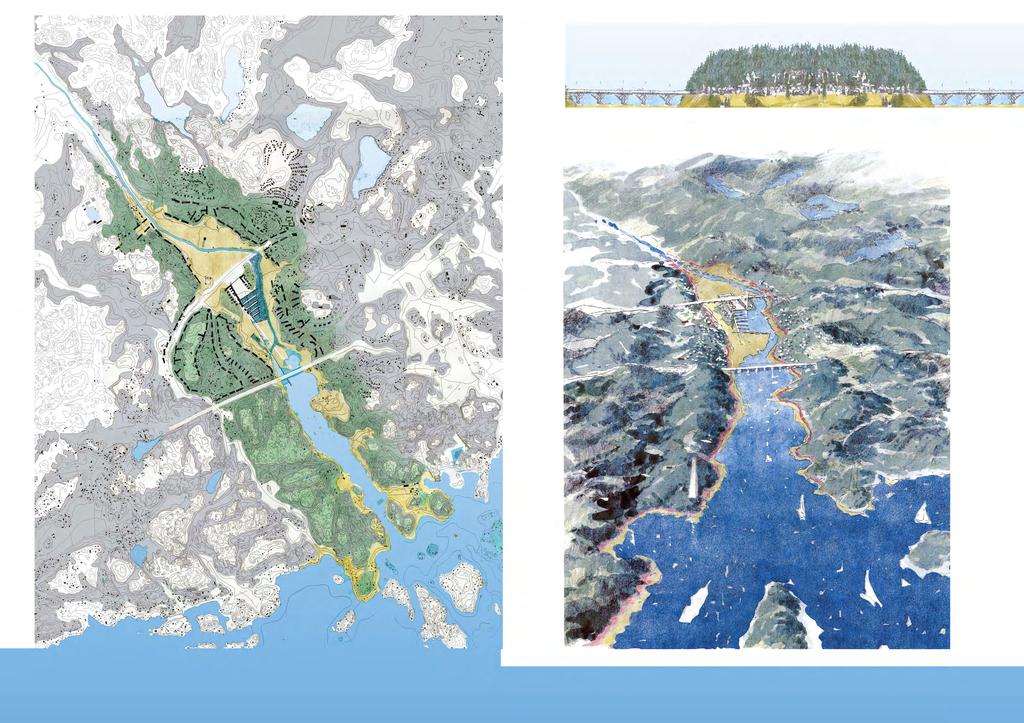
3 OVERALL SITE PLAN PANORAMIC VIEW


4 SECTION - ELEVATION FOREST WETLANDS OUTDOOR THEATER INDOOR THEATER RUINS NEW SQUARE LOFTS HILL HOUSES CENTRAL PLAN RIVER ENTRANCE

5 HILL TOWN TERRACED WALK VIEW FROM THE MARINA TOWN SQUARE

6 OVERLOOK TOWER UNIVERSITY HILL INTIMATE SIDE STREET WATERFRONT FUTURE HILL TOWN

7 SIBBESBORG HEART AND SOUL
8 We were inspired by * the extraordinary natural beauty of the PLACE with its unique striation, * the PEOPLE s vision and commitment to democracy in action and * the civic PURPOSE: to protect the natural and cultural treasures of the site and slowly and gently introduce the projected population growth. We chose to start small and compact, with a new HEART that commands the Sipoo valley and will be embraced by future expansion along the surrounding hills. A new central civic squares opens up to the landscape and welcomes PEOPLE with an open heart. A new light tower will mark the entrance to the ruins of the Sibbesborg fort that give the town its name and its soul. This unique heart will fulfill all five themes: LANDSCAPE: This heart is nestled between the twin islands of Sibbesborg and Joensuu, commanding the strategic intersection of Sipoonlahti (Sipoo Bay) and the Sipoonjoki (Sipoo River) valley. It is set within a park extending from the archipelago along the coast of the Gulf of Finland to the Sipoo river valley; this park will protect most of the significant natural and cultural landscapes. The new heart is inspired by the striation of the landscape. The shoreline at the base has sandy beaches, wetlands, grasses, or cultivated meadows depending on the location. The hillsides have steep cliff walls with rocky patches: pine and hardwood forests with a diverse herb understory. These forests create a soft profile against the sky. The park s boundaries encompass most historic and pre-historic settlements from the Bronze Age, the Middle Ages,19th century manor houses, and at the center, the ruins of the 14th century Sibbesborg fort. These historic sites will be marked and lit at night, reflected in the water and accessed by park walks. Educational programs in schools and local clubs will promote knowledge and stewardship of both the natural and cultural landscapes. fig. 1. New heart within park boundaries encompassing most historic sites.
9 TRANSPORTATION: The new urban growth is introduced within the natural striation of the landscape with a simple architectural code: wooden loft buildings frame the central plaza and sit on pilotis along the waterfront and wood terraced housing follow the contours of the hills. The top of the hills retain the natural forest profile, with a possible exception for a cultural building as an acropolis on Sibbesborg hill. Typically, the loft buildings on pilotis are inspired by the great historic waterfront warehouses in neighboring Porvoo and in Bergen, Norway. These are both Unesco world heritage sites and culturally connected to the site via the old King s Road. They are long linear parti-wall buildings and create city blocks, with a public front facade, private back yard and very narrow side streets. This heart will be a destination by land and sea. The water offers the most romantic route. A new sequence of light towers will offer navigational orientation from the sea by marking significant thresholds: coastline archipelago, bay and river. To encourage public and private waterfront use, there will be a new marina next to the main square and a pier for sailboats. A walk connects from the train station, to the square, the marina, over the wetlands to the pier in the Bay. Ideally, in the future, a new drawbridge on the Porvoonväylä highway will allow sailboats to reach the central marina next to the square. The terraced housing rise up on the twin hills under the forest canopy. The houses fit gently within the existing forest, especially the hardwoods in Joensuu. Like most of the existing houses, they will be within a range of meter above sea level. Because they adjust to the topography, they are more idiosyncratic in their orientation in plan. The houses closer to the center might also share a party wall and have a smaller lot; further away they are free standing. fig. 2. Water transportation.
10 It will be served by the local Helsinki-Porvoo commuter line (HELI) and a cross-country train following the ancient Kuninkaantie or King s Road. This 14th century mail road extended from Bergen on the Atlantic coast, connected Oslo, Stockholm, Mariehamn, Turku, Helsinki, Sipoo, Porvoo and ended in Vyborg (later in St. Petersburg, Russia). Near Sibbesborg, the trains will follow the Uusi Porvoontie right of way. This rural road will become a multi-modal boulevard including railroad, commuter train, public transit, bicycles and pedestrians and in multiple lanes divided by landscaped medians. To address the narrow valley between the hills, the boulevard will be multi-level in section, with a mid-level pedestrian walkway along the hillside. These pedestrian walks will be connected by bridges across the valley. As the city grows, the Uusi Porvoontie road will become a more urban boulevard framed by mixed-use buildings. It will have the new heart at the center and extend to the school at Söderkulla to the east and a new University campus to the West. To the north, a new multi-purpose bridge will cross the Sipoo River valley as it narrows. It will alleviate local traffic and complete two traffic loops: the terraced walks along the valley and a street with public transit, (buses and light rail) and infrastructure to serve the existing and new neighborhoods on either side. Everything in the heart is within walking distance and connected to trails to the adjacent towns and mountains. fig. 3. Uusi Porvoontie as an Urban Boulevard. fig. 4. New bridge to the north and ring road.
11 LIFESTYLE: ECOLOGY: The new heart will radiate life all day and all year long. The central square will welcome people with an open heart. It will be the stage to watch people, eat and drink with friends and neighbors, hold markets and civic events: concerts, dances, ice-skating and races. Its markets will feature local produce, dairy and fowl from adjacent farms, and fish from the fish market. The slope next to the ruins of the fort creates a natural amphitheater for summer festivals; a new theater building will have a double stage to open to the amphitheater in the back. The new heart will offer a range of living arrangements and house types. This square is framed by multi-purpose, live-work lofts to create a compact town that is walkable and accessible by train, boat and multiple trails. Protecting the Sipoo River Valley as a new central park will expand public opportunities for outdoor recreation next to the heart of the city and its future expansion. There will be new trails for walking, cycling and horseback riding. There will be new ways to enjoy the water, including new piers for sailboats in Sipoo Bay and small motor craft and kayaks in the marina. The whole area will offer winter sports: cross-country skiing, snow shoeing, sledding, ice-skating etc within walking distance from the heart of the city. The compact heart offers a small ecological footprint. It reintegrates life and work, minimize commuting time, space and cost and reduce energy consumption. Private car and service vehicles will be restricted to certain times of the days and to service alleys at the bottom of each hill. It will protect the landscape and minimize forest clearance. If possible, use the cut trees for new construction. It will offer an alternative lifestyle with walking, bicycles, cross-country skiing and snow shoes, public transit by land and water, even horseback riding. The hills and intimate side streets will offer wind protection and create a milder microclimate. Compact development also offers energy efficiency. A small extension of the energy grid will be sufficient. It could integrate multiple alternative energy sources: passive energy features through design and orientation, solar panels where appropriate and the hills could be used for geothermal energy installations. To heal the eutrophication of the river and delta, we propose wetlands along the park perimeter to filter storm water from restored creeks, farms and towns before reaching the river. We recommend connecting and uncovering creeks in the region and minimizing agricultural and industrial waste from going into the watershed. These wetland paths will be also the connecting the monuments.
12 EMPLOYMENT AND SERVICES: A new water management system is needed to heal the eutrophication of the river and the delta. This includes managing existing wetlands to promote healthy habitats, reconnecting and uncovering creeks that were channeled and/or covered and promoting new practices to minimize agricultural and industrial waste from going into the watershed. We introduce a new ring of shallow wetlands along the perimeter of the park to collect and filter storm water from creeks, farms and adjacent settlements before reaching the river. The paths along these wetlands will also tie to those connecting the monuments. As it grows, Sissesborg s local economy will offer employment opportunities and markets. It will create a local food market for the neighboring farms, making them more economically viable. It could also promote local bakeries, creamery for milk, yogurt and cheese, bee-keeping for honey and other small artisanal food production. As a tourist destination it can create jobs for guides, instructors for outdoor activities, tour operators, as well as catering and hospitality. On the ground floor, it will house retail and entertainment, restaurants, bars, etc... The mezzanine houses offices, including incubator spaces to promote new entrepreneurial ventures. The fish market and the marina will also be destinations supporting economic activities, including jobs to service boats. The Uusi Porvoontie urban boulevard will become the major spine for work, jobs and services. The multi-story buildings framing the boulevad will include commercial below, office space and apartments with great views of the valley. The boulevard will connect the existing school complex to the east with a new university campus and hospital complex to the west. fig. 5. New ring of wetlands filters run-off. Uncover and reconnect creeks. The University hill will provide higher education and research labs. It will serve as an incubator for entrepreneurs to create new experimental local companies and new jobs.
13 IMPLEMENTATION PHASES: We advocate a compact city with very intense investment on the new heart and the landscape. As the population grows beyond this initial phase, the heart and its park setting will be embraced by a new expansion ring set within the forest of the surrounding hills, and reinforcing the frame created by the topography. This expansion will reconnect the neighboring Söderkulla, Hansas, Eriksnäs to create an interconnected public realm. We recommend a series of urban blocks, allowing view corridors to the valley and many cross paths for public access. This is in contrast to the current pattern of suburban sub-divisions with cul-de-sacs, which is environmentally unsustainable. It creates dead ends that increase the effective distance between places, increase reliance on private cars and therefore, increase traffic congestion. These are suggested phases: and Phase 1. The heart of the town with the surrounding park in the Sipoo Bay and River valley. 5,000 10, Create the new central square, surrounded by private loft buildings and with the pedestrian bridges across the valley Define the park boundaries to protect its natural and archeological treasures. This will include public and private properties, including forests and farms. Build new public paths and trails Implement the new water management system, including the new wetlands along the edge of the park Establish multiple public- private partnerships to implement these different goals. These might entail land purchases or land swaps between public and private properties. PHASE 2. The Uusi Porvoontie urban boulevard to Söderkulla. Up to 15, Transform the road into a desirable boulevard Extend on both sides of the street and connect to the existing school It integrates existing buildings along the road New multi-story commercial, office and housing will frame the boulevard. 2.5 This will be a multi-level boulevard, with public sidewalks above street level where necessary. This elevated public sidewalk will connect to the bridges across the valley leading to the heart of the city. fig. 6. Phases of growth..
14 PHASE 3. North East quadrant. 10, This creates an arc of development with a new public promenade along the ridge that offers views of the Sipoo river valley. 2. It will connect to Söderkulla and Hansas and provide them with both visual and physical access to the river. 3. Most of the new development is on the intermediate terrace between 10 and 25 m. above sea level. 4. It will frame and protect the Söderkulla Manor estate. 5. Density increases next to the loop road and decreases along the waterfront to keep the forest edge. PHASE 4 and 5. South East quadrant. 20, This also creates an arc of development with a new public promenade along the ridge with views of the Sipoo river valley. 2. Add a new road in the vicinity roughly parallel to Eriksnasintie, the main north south road, to improve access and set up the main traffic loop for public transit. 3. It leads to Eriksnas and Kallback south of the highway. 4. Part of the development is on the intermediate terrace and part is at valley level. 5. Density increases closer to the loop road. PHASE 6. West side of Uusi Porvoontie urban boulevard. 10,000. Due to the current small population on the west side of the valley, we are speculating this side would be a later stage. Previous phases, such as the success of the new heart and a new station in the center, might make the west side of the urban boulevard a higher priority. PHASE 7 and 8. South West quadrant. Like phase 6, this quadrant might be developed sooner once the new heart at the center is well established. This quadrant has two levels and corresponding phases. Phase 7 is at valley level, next to the marina and Phase 8 is on the wooded hill, with excellent views of Sipoo Bay and the islands along the coast. PHASE 9 North West quadrant. 10,000. Previous phases, including the new heart, will provide incentives for developing this area. The new bridge at the north of the valley and completing the Loop road will improve public access and transit. PHASE 10 University Hill 10,000. A new college - university - research campus would be a major engine and it will balance development on both sides of the valley. It will be more viable with the new heart in place. It can be independent from the other phases.
15 ABSTRACT We chose to start small and compact, with a new HEART commanding the valley and embraced by future expansion along the surrounding hills. The new civic squares welcomes people and the landscape with an open heart. It is next to the Sibbesborg ruins that give the town its name and soul. This unique heart fulfills all five themes: Landscape: It is nestled between the twin islands in the Sipoo Bay and River valley. In this striated landscape new wooden loft buildings frame the civic square and houses rise up the hills. Transportation: A destination by land and sea, it is served by a local commuter and a cross-country train along the old King s Road, with a new pier and marina. Lifestyle: Alive all day long with mixed-use life-work lofts and all year long with outdoor play. Ecology: A small footprint reduces forest clearance, commuting and energy use. The hills offer geothermal power and wind protection. Jobs and services: a new spine for markets, a future university and hospital.
SIBBESBORG COMPETITION
 1/4 FOR SUSTAINABLE COMMUNITY DEVELOPMENT SIBBESBORG COMPETITION OVERALL PLAN 1:15000 Principles of the design and the path to realisation History reborn. The proposal is constructed on the history of
Sibbesborg: Competition for Sustainable Community Development
 Sibbesborg: Competition for Sustainable Community Development Pseudonym "Sibblings" Description The urban structure of Sibbesborg is based on a combination of several mutually connected centres. Each of
Description of Preferred Alternative
 Chapter 2 Description of Preferred Alternative 2.1 Introduction This chapter of the programmatic Sammamish Town Center Sub-area Plan Final EIS provides a more detailed description of the Preferred Alternative
4 C OMMUNITY D ISTRICTS
 4 C OMMUNITY D ISTRICTS N ew development in the Area will include many different types of land uses, including a destination retail area that attracts people from all over the region; recreation opportunities
Seneca Meadows. Block 4 Locate office, technology, and medical development adjacent to I Screen views of garage structures from I-270.
 Seneca Meadows Seneca Meadows has an industrial park in its southern end and a mixed-use employment area planned for the north end. The district benefits from extensive I-270 visibility, stream valley
Regional Context Statement
 Regional Context Statement REGIONAL CONTEXT STATEMENT 3. REGIONAL CONTEXT STATEMENT In 1995, the Provincial Government passed into law the Growth Strategies Act. The purpose of this provincial initiative
Community Design Guidelines. Port Wallace DRAFT
 Community Design Guidelines Port Wallace DRAFT Energy 1 2 3 Nature Movement Connections Built Form DRAFT Layout Energy 1 Nature Community Design Guidelines GREAT COMMUNITIES PROTECT, CELEBRATE, AND CONSERVE
City of Kingston. North King s Town Secondary Plan Open House + Workshop #1 February 28, 2018
 City of Kingston North King s Town Secondary Plan Open House + Workshop #1 February 28, 2018 1 event agenda 30 min Panel Review + Discussion 30 min Presentation + Q&A 75 min Workshop Session 15 min Report
CHAPTER 3 VISION, GOALS, & PLANNING PRINCIPLES. City of Greensburg Comprehensive Plan. Introduction. Vision Statement. Growth Management Goals.
 CHAPTER 3 VISION, GOALS, & PLANNING PRINCIPLES Introduction The Greensburg Comprehensive Plan is intended as a working community document. A combination of long and short-term goals, this document is intended
What Pioneer Grove Will Look Like?
 The City of Deerfield Beach has embarked on a journey to create a new town center within the old heart of Deerfield Beach. The new town center is known as Pioneer Grove. Pioneer Grove will be Everybody
HE VISION. Building a Better Connected Place
 HE VISION Building a Better Connected Place WALK INTO THE FUTURE. Life in Cranberry, 2030 Here s what our residents told us they wanted to see in their community by 2030: The Cranberry of 2030 is a place
10.0 Open Space and Public Realm
 10.0 Open Space and Public Realm 10.0 Open Space and Public Realm The Public Open Space System is comprised of: outdoor spaces available for public use that are either publicly owned (e.g., parks and
appendix and street interface guidelines
 appendix five: building and street interface guidelines appendix 5 building and street interface guidelines BOULEVARDS Boulevards are generally characterized by higher levels of traffic movement at higher
INTRODUCING THE BALTIMORE CITY GREEN NETWORK VISION PLAN
 INTRODUCING THE BALTIMORE CITY GREEN NETWORK VISION PLAN GOALS OF THE GREEN NETWORK PLAN Protect and enhance the unique ecological resources of our city Support economic growth and sustainable redevelopment
Plano Tomorrow Vision and Policies
 Plano Tomorrow Vision and Policies PLANO TOMORROW PILLARS The Built Environment The Social Environment The Natural Environment The Economic Environment Land Use and Urban Design Transportation Housing
CHAPTER 7: Transportation, Mobility and Circulation
 AGLE AREA COMMUNITY Plan CHAPTER 7 CHAPTER 7: Transportation, Mobility and Circulation Transportation, Mobility and Circulation The purpose of the Transportation, Mobility and Circulation Chapter is to
PORT OF VANCOUVER WATERFRONT DEVELOPMENT. Concept Development Plan City Center Redevelopment Authority April 20, 2017
 PORT OF VANCOUVER WATERFRONT DEVELOPMENT Concept Development Plan City Center Redevelopment Authority April 20, 2017 Port History PORT ESTABLISHED 1912 TERMINAL 1 ACQUIRED 1925 GWM SIGNS LEASE 1935 HARBOR
Town Center. Block 5 Existing multifamily residential units are expected to remain.
 Area Guidelines Germantown s districts should be developed as distinct communities with unique features that are supported through the guidelines. The guidelines not only help distinguish these districts
THE 355/270 CORRIDOR:
 THE 355/270 CORRIDOR: Strategic Ideas for Sustaining a Livable Work Place Project Summary ACCESS LIFE DESIGN HEALTH WORK Montgomery County Planning Department The Maryland-National Capital Park and Planning
This Review Is Divided Into Two Phases:
 Semiahmoo Town Centre Review The purpose of this review: To review the Semiahmoo Town Centre Concept Plan, originally approved in 1993, to ensure that this centre will continue to serve the needs of South
SQUAMISH 2010 AND BEYOND COMMUNITY VISION
 Our plan has been imagined and created to be both pragmatic and visionary. At the core of the strategy is a consideration of the highway s role and its impact on the community. First and foremost in creating
BROOKHILL NEIGHBORHOOD MODEL ZONING MAP AMENDMENT PREFACE TO APPLICATION
 BROOKHILL NEIGHBORHOOD MODEL ZONING MAP AMENDMENT PREFACE TO APPLICATION June 15, 2015 Revised: August 1, 2016 I. VISION Brookhill is a proposed community based upon the principles of Albemarle County
Policies and Code Intent Sections Related to Town Center
 Policies and Code Intent Sections Related to Town Center The Town Center Vision is scattered throughout the Comprehensive Plan, development code and the 1994 Town Center Plan. What follows are sections
Comprehensive Plan Advisory Panel Meeting #3
 Comprehensive Plan Advisory Panel Meeting #3 November 7, 2016 Agenda 1. September 19 th Meeting Notes 2. Summary of Focus Areas Charrette 3. Heart of the City Focus Area a. HOC2/Station Areas Concept &
ALTERNATIVE STATION AREA -
 ALTERNATIVE STATION AREA - THE 10 TH STREET GARDEN STATION Two alternative land use scenarios and designs are illustrated here: Scheme A - Transit-Oriented Development High to Mid-Density Residential /Office
chapter DESIGN GUIDELINES NEW RIVER MASTER PLAN REPORT
 chapter DESIGN GUIDELINES NEW RIVER MASTER PLAN REPORT .76 DESIGN GUIDELINES An Overview design guidelines NEW RIVER MASTER PLAN Design Guidelines can transform the image of a city. Specific, design-based
Preliminary Sketch Plan for Fort Hunter Park
 Preliminary Sketch Plan for Fort Hunter Park Public Presentation November 19, 2009 Dauphin County Parks and Recreation 100 Fort Hunter Road Harrisburg, PA 17110 (717) 599-5188 www.dauphinc.org THOMAS COMITTA
Silverdale Regional Center
 Silverdale Regional Center Vision for Silverdale Regional Center The Silverdale Regional Center Plan (Plan) will guide the evolution of the Silverdale Regional Center from a collection of strip malls and
LAKEVIEW VILLAGE VISION & MASTERPLAN PRESENTATION TO CITY OF MISSISSAUGA. April 9, 2018
 LAKEVIEW VILLAGE VISION & MASTERPLAN PRESENTATION TO CITY OF MISSISSAUGA April 9, 2018 AGENDA Introduction Vision Plan Comparison The Big Moves Trail Connections Plan Overview Districts Conveyance Comparison
THE NEIGHBORHOOD TODAY
 THE NEIGHBORHOOD TODAY CORE AREA VISION How are we Good Urbanism A Site s DNA thinking about Elements of great Unique elements urban communities embedded in a place the site and design? ELEMENTS LIKE:
1.0 VISION STATEMENT. December 6, PRINCIPLES
 Vision Statement Lincoln Regional Airport 1.0 VISION STATEMENT 1.1 City LOCATION of AND OVERVIEW The Easton Lincoln Place Land Use Master Plan identifies the principles, goals, policies, and standards
April 21, 2007 CCRP Workshop Summary
 April 21, 2007 CCRP Workshop Summary Group 1 1. Reuse around BART with a lot of housing and jobs 2. Greenway around creek 3. Transit and auto connection all through the site from Kirker Pass to Port Chicago
V. Gateways GATEWAYS / V-1
 V. GATEWAYS / V-1 Many of Chesapeake s gateways are located on highways and call for bold and attractive designs that motorists can understand, appreciate, and enjoy. can also take the form of natural
Corridor Vision. 1Pursue Minnehaha-Hiawatha Community Works Project. Mission of Hennepin County Community Works Program
 1Pursue Minnehaha-Hiawatha Community Works Project Minnehaha-Hiawatha Community Works is a project within the Hennepin Community Works (HCW) program. The mission of the HCW program is to enhance how the
City of Poughkeepsie Waterfront Redevelopment Strategy. Poughkeepsie Waterfront Redevelopment Strategy
 City of Poughkeepsie Waterfront Redevelopment Strategy Poughkeepsie Waterfront Redevelopment Strategy City of Poughkeepsie Prime Assets: Major Waterfront Advantages: - Central City of the Hudson River
A Vibrant Downtown. Chapter 5 Cary Public Art Opportunities 31
 A Vibrant Downtown Cary s vision for Downtown is a unique, vibrant, dynamic, pedestrian friendly location; a regional destination and a place to live, work, and recreate, according to the 2001 Town Center
Pioneering the Sustainable Future of Pakistan. A New Destination of Islamabad
 Pioneering the Sustainable Future of Pakistan A New Destination of Islamabad A New Destination of Islamabad C A P I TAL S M A R T CIT Y ISL A M A B A D, PAKISTA N CAPITAL SMART CITY ISLAMABAD C A P I TAL
ATTACHMENT A. SILVERDALE DESIGN STANDARDS Amendments to the Waaga Way Town Center Chapter
 ATTACHMENT A SILVERDALE DESIGN STANDARDS Amendments to the Waaga Way Town Center Chapter Chapter 10. Waaga Way Town Center 10.1 Physical Identity Elements & Opportunities The Waaga Way Town Center includes
Sahuarita District & Phase 1 Master Plan. Town Council December 11, 2017
 Sahuarita District & Phase 1 Master Plan Town Council December 11, 2017 Visioning Study Visioning Process Advisory Group Meetings Community Questionnaire Town Center Case Studies Community Analysis The
ELK GROVE GENERAL PLAN VISION
 2-1 CHAPTER 2: 2-2 CREATING OUR The Community Vision for Elk Grove, expressed through a Vision Statement and a series of Supporting Principles, is a declaration of the kind of community that Elk Grove
Pine Island Road Corridor Master Plan
 RECOMMENDED DEVELOPMENT PLAN Figure 9: Del Prado Village District Conceptual Framework The Conceptual Framework (Figure 8) for development of the Pine Island Corridor is to encourage mixed-use development
Title: South Britannia Community Centre Tobi Fenton
 Title: South Britannia Community Centre Tobi Fenton South Britannia is laid out in a grid of 120x60 meter blocks with Main Street oriented towards Howe Sound. The concentrated centre is located at the
Town Center (part of the Comprehensive Plan)
") Town Center (part of the Comprehensive Plan) Mercer Island Town Center Looking North (2014) In 1994, a year-long process culminated in a set of design guidelines and code requirements for the Town Center
Town Center (part of the Comprehensive Plan) Mercer Island Town Center Looking North (2014) In 1994, a year-long process culminated in a set of design guidelines and code requirements for the Town Center
PORT WHITBY COMMUNITY
 PORT WHITBY COMMUNITY SECONDARY PLAN UPDATE COMMUNITY IMPROVEMENT PLAN URBAN DESIGN GUIDELINES September 2015 DRAFT PROPOSED AMENDMENT NUMBER # to the Whitby Official Plan PURPOSE: The intent of this Amendment
SALISBURY TOMORROW Our Vision
 SALISBURY TOMORROW Our Vision Salisbury is committed to supporting a high quality of life and sense of community for all residents. These commitments need to be reflected in our community programs, services
EXISTING COMPREHENSIVE PLAN
 EXISTING COMPREHENSIVE PLAN Town Center Land Use Element: V. LAND USE POLICIES Town Center Mercer Island's business district vision as described in "Your Mercer Island Citizen-Designed Downtown" was an
Welcome! to Keller Town Hall
 Welcome! to Keller Town Hall Keller Town Center Planning a New Downtown What is Keller Town Center? A new, growing downtown district planned as an urban village A combination of retail and office spaces,
The Plan for Port Whitby
 The Plan for Port Whitby December 5, 2012 Community Meeting Summary Report Prepared by GLPi January 17, 2013 1 Introduction The purpose of the Port Whitby Secondary Plan Update, Community Improvement Plan
TRANSIT ORIENTED DEVELOPMENT PINELLAS COUNTY MPO LIVABLE COMMUNITIES INITIATIVE PINELLAS COUNTY COMPREHENSIVE PLAN AMENDMENTS
 PINELLAS COUNTY MPO LIVABLE COMMUNITIES INITIATIVE MODEL LAND DEVELOPMENT CODE TRANSIT ORIENTED DEVELOPMENT PINELLAS COUNTY COMPREHENSIVE PLAN AMENDMENTS MPO Livable Communities Initiative Goal: Improve
MAYFIELD WEST SECONDARY PLAN PHASE 2
 MAYFIELD WEST SECONDARY PLAN PHASE 2 Public Open House #3 February 25, 2010 Draft Preferred Land Use Scenario TOWN OF CALEDON PLANNING & DEVELOPMENT DEPARTMENT Open House Agenda TOWN OF CALEDON 1. Welcome
EcoVerde MADISON TO DOWNTOWN TO BEACH. Legend Highway Major Connection Major Street Local Street Proposed Access. Response to Tropicana Field RFP
 EcoVerde TO BEACH 275 16th Street North 16th Street South 13th Street North 13th Street South 11th Street North 11th Street South 1st Avenue North Central Avenue 1st Avenue South TO DOWNTOWN 2nd Avenue
Ivywild On The Creek PRELIMINARY CREEK DISTRICT MASTER PLAN
 Ivywild On The Creek PRELIMINARY CREEK DISTRICT MASTER PLAN Introduction: Rejuvenating an extraordinary Creekside neighborhood THE CREEKSIDE DISTRICT The Ivywild On The Creek Neighborhood District Master
III. Design Principles
 III. Design Principles The design of Bay Meadows Phase II has been guided by a series of Urban Design Principles. These principles, informed by consultant site analysis, City staff recommendations, and
DRAFT. 10% Common Open Space
 % OF CHARLOTTE IS CATEGORIZED AS A. LAND USES : Placeholder map displaying location of Place Type GOALS: Accommodate XX% of future growth. Provide a concentration of primarily commercial and civic activity
Nader Obied Abd al raheem hathat. Dr. Farid S. Al-Qeeq
 Submit from Nader Obied Abd al raheem hathat Submit to Dr. Farid S. Al-Qeeq DEC. 2010 NEW URBANISM : is the most important planning movement this century, which emerged during the late 1980s and early
THEMES, VISION, + PRINCIPLES
 CHAPTER 2: THEMES, VISION, + PRINCIPLES This page intentionally left blank. 20 VISION DRAFT AUGUST 2018 2 2 THEMES, VISION, + GUIDING PRINCIPLES The Key Themes, Vision, and Guiding Principles presented
Waterfront Development Master Plan
 PORT of VANCOUVER USA Vancouver, WA Waterfront Development Master Plan DRAFT - FINAL CONCEPTUAL MASTER PLAN PROJECT TEAM NBBJ Heritage Research Associates JLA Kittelson Associates Leland Consulting Group
Draft Memorandum #1: Goals and Vision for Revitalization
 Keizer Revitalization Plan Draft Memorandum #1: Goals and Vision for Revitalization Submitted to: City of Keizer April 12, 2018 (revised) Prepared By: Angelo Planning Group and Otak, Inc. Project No. 17482.A
Today Land & People. Northeast Nampa Gateway District. Employment. Land Use Characteristics. Demographics. Current Zoning
 Today Land & People Employment Major employers include Saint Alphonsus, the College of Western Idaho, the Auto Mall, Sorrento Lactalis and Walmart. 3,004 jobs in 2010 (COMPASS-CIM 2040 TAZ data) 4,345
Mix of Uses Guide for Transit-Oriented Development MIX OF USES
 MIX OF USES Creating a Destination Magnet A diversity of uses such as retail, housing, offices, civic and entertainment within the TOD creates a destination magnet for transit users and TOD neighbors.
2. Form and Character. 2.1 Introduction. 2.2 The Downtown Addition Plan. 2.1 Introduction
 2.1 Introduction 2.1 Introduction This section of the Specific Plan describes and illustrates the desired form, character and uses of the Downtown Addition and explains the underlying design principles.
Reconnecting to a Forgotten River St. Cloud MN. Aaron Hanson Design Design Thesis LA 572, Thesis, Spring 2012
 Reconnecting to a Forgotten River St. Cloud MN Aaron Hanson Design Design Thesis LA 572, Thesis, Spring 2012 site context 2.5 Miles Sartell St. Cloud to Fargo 170 Miles (2 hrs 45 mins) Hwy 10 infrastructure
Master Site Development Plan (MSDP) Rocky View County Campus at Balzac East
 Rocky View County Campus at Balzac East") Master Site Development Plan (MSDP) Rocky View County Campus at Balzac East Balzac East, Alberta July 2009 CONTENTS 1.0 purpose 1 2.0 guiding principles 2 3.0 site description 3 4.0 site analysis and county
Master Site Development Plan (MSDP) Rocky View County Campus at Balzac East Balzac East, Alberta July 2009 CONTENTS 1.0 purpose 1 2.0 guiding principles 2 3.0 site description 3 4.0 site analysis and county
Overview of the Plan. The Building Blocks of Centers, Neighborhoods and Network INTERNAL DRAFT
 Overview of the Plan 4 East Davidson Ramah Church Rd June Washam Rd Bradford District Park Bradford Shearer Rd Campus District NC 73 Davidson-Concord North Rocky River This Master Plan projects an approximate
3.1 Existing Land Use
 3.0 Land Use This strategy has been developed taking into account the position of the Town of Sidney as the economic center of the Saanich Peninsula. It acknowledges existing land use patterns in the downtown
Courthouse Square Planning & Urban Design Study. Courthouse Square Working Group #13 October 15, 2014
 Courthouse Square Planning & Urban Design Study Courthouse Square Working Group #13 October 15, 2014 1 Courthouse Square Process Working Group Community Courthouse Square Advisory Groups & Civic Associations
ENVISIONING TOMORROW S FORT MYERS BEACH
 ENVISIONING TOMORROW S FORT MYERS BEACH NATURAL ENVIRONMENT... 2-1 MOBILITY... 2-1 TIMES SQUARE... 2-1 AVENUE OF PALMS... 2-2 RESIDENTIAL NEIGHBORHOODS... 2-2 A SECOND MAIN STREET... 2-4 FORT MYERS BEACH,
Clair-Maltby Community visioning
 Clair-Maltby Community visioning workshop #1 Summary April 27th, 2017 Table of Contents INTRODUCTIon 1 PURPOSE 1 CONSULTATION STRUCTURE 2 PARTICIPANT FEEDBACK 3 VISIONING EXERCISE 8 ONLINE SURVEY RESULTS
Chapter 4. Linking Land Use with Transportation. Chapter 4
 Chapter 4 Linking Land Use with Transportation Chapter 4 59 Chapter 4 Linking Land Use with Transportation Community Design and Transportation Program Introduction Since the 1950s, the predominant development
Neighborhood Districts
 NEIGHBORHOOD DISTRICTS SEVEN MAIN DISTRICTS Neighborhood Districts While the Development Plan provides a broad-scale overview of the neighborhood, this section focuses on uses and relationships at the
Public Meeting #3 May 9, 2009 MVVA Team
 Public Meeting #3 May 9, 2009 MVVA Team Welcome to the third Public Meeting for the Lower Don Lands Municipal Class Environmental Assessment (EA) Infrastructure Master Plan and Keating Channel Precinct
Purpose of Open House #3
 Public Meeting #3 May 9, 2009 MVVA Team Purpose of Open House #3 The main purpose of this Open House is to present and seek input on the: Evaluation of transportation and infrastructure design alternatives
MCCOYS CREEK RESTORATION 30% DESIGN
 MCCOYS CREEK RESTORATION 30% DESIGN THE MCCOYS CREEK RESTORATION PLAN The restoration plan aims to reduce flooding, restore ecosystem health, expand recreational opportunities along the creek, and connect
Bay Meadows Specific Plan Amendment - Phase II Overview. I. Phase II Overview. November 7, 2005 I - 1
 I. Phase II Overview November 7, 2005 I - 1 Explanatory Note This Specific Plan Amendment amends the Bay Meadows Specific Plan adopted by the San Mateo City Council on April 22, 1997. The original Specific
Sustainability, Health, Safety, Recreation & Open Space Working Group August 3, 2017
 Sustainability, Health, Safety, Recreation & Open Space Working Group August 3, 2017 DOWNTOWN OAKLAND SPECIFIC PLAN WELCOME Sustainability, Health, Safety, Recreation & Open Space Working Group Social
NORTH CLAYMONT AREA MASTER PLAN COMMUNITY WORKSHOP #1 FEBRUARY 3, 2016
 NORTH CLAYMONT AREA MASTER PLAN COMMUNITY WORKSHOP #1 FEBRUARY 3, 2016 1. Introduction To the team and to the Plan Planning Partners The Claymont Community WILMAPCO New Castle County Claymont Renaissance
Sustainable City of the Future LUSAIL
 Sustainable City of the Future March 2013 1 2013 - Lusail Real Estates Development Company 2 CITY Lusail City Vision To build a strong social and cultural foundation into a technologically advanced modern
Stakeholders Advisory Working Groups (SAWGs) Smart Growth and TOD Land Use (#11) SAWG Meeting
 Smart Growth and TOD Land Use (#11) SAWG Meeting") Presentation - Part II Tappan Zee Bridge/I-287 Corridor Project July 21, 2010 Slide 1. David Kooris (Regional Plan Association) welcomed members of the Land Use Stakeholders Advisory Working Groups (SAWGs)
Presentation - Part II Tappan Zee Bridge/I-287 Corridor Project July 21, 2010 Slide 1. David Kooris (Regional Plan Association) welcomed members of the Land Use Stakeholders Advisory Working Groups (SAWGs)
E. RURAL COMMERCIAL/INDUSTRIAL PARK MODEL
 E. RURAL COMMERCIAL/INDUSTRIAL PARK MODEL 1. PURPOSE The purpose of the Rural Commerce/Industrial Park Model is to provide parameters within which a grouping of business buildings with parking, loading
PLAN ELEMENTS WORKSHOP. April 5, 2016
 PLAN ELEMENTS WORKSHOP April 5, 2016 needs more housing. But there is no one-size fits-all solution. Every neighborhood has its own character. In some places, density is not only appropriate it is badly
CHONGMING ISLAND SHANGHAI CENTRAL CITY
 Chongming Island CHONGMING ISLAND SHANGHAI CENTRAL CITY Chongming Island Shanghai, China THE VISION: A GREEN ISLAND Chongming Island benefits from a magnificent setting, adjacency to the vibrant center
WELCOME and introduction
 1 WELCOME and introduction Mobility Hub Locations within Burlington STUDY OVERVIEW STUDY OBJECTIVES The City of Burlington is developing four Area Specific Plans, one for each of Burlington s Mobility
PROPOSED REDEVELOPMENT OF THE GLEN ABBEY GOLF CLUB. STREETSCAPE DESIGN STUDY (excerpt from the Urban Design Brief) TOWN OF OAKVILLE.
 TOWN OF OAKVILLE.") PROPOSED REDEVELOPMENT OF THE GLEN ABBEY GOLF CLUB STREETSCAPE DESIGN STUDY (excerpt from the Urban Design Brief) TOWN OF OAKVILLE OCTOBER, 2016 for 2.4.2 STREETS Streets are the single largest component
PROPOSED REDEVELOPMENT OF THE GLEN ABBEY GOLF CLUB STREETSCAPE DESIGN STUDY (excerpt from the Urban Design Brief) TOWN OF OAKVILLE OCTOBER, 2016 for 2.4.2 STREETS Streets are the single largest component
St. Louis Park Wooddale LRT Station Site development guidelines
 St. Louis Park Wooddale LRT Station Site development guidelines November 2013 OVERVIEW St. Louis Park s convenient location as a neighbor to Minneapolis means you re only minutes away from some of the
I615. Westgate Precinct
 I615. Westgate Precinct I615.1. Precinct Description The Westgate Precinct is located approximately 18km west of the Auckland city centre. There are seven Sub-precincts in the Westgate Precinct: Sub-precinct
REGIONAL ACTIVITY CENTER
 DRAFT REGIONAL ACTIVITY CENTER 70 EAST BENCH MASTER PLAN DRAFT 06 Introduction The East Bench Regional Activity center is comprised of large educational, research, medical, and employment centers. These
Chapter 6--Urban Design
 6.1 Introduction... 6-1 6.1.1 Background & Scope... 6-1 6.1.2 Relationship to State Law... 6-2 6.1.3 Relationship to Other General Plan Chapters... 6-2 6.2 Guiding Principles... 6-2 6.3 Urban Design Guidelines...
Plano Tomorrow Joint Work Session
 Plano Tomorrow Joint Work Session City Council and Planning & Zoning Commission June 30, 2014 Strong Agreement More than 80% of respondents agreed with the statement. (9 of 16) Agreement Between 60% and
Gold Line Bus Rapid Transit Transit Oriented Development (BRTOD) Helmo Station Area Plan
 Helmo Station Area Plan") Appendix F Gold Line Bus Rapid Transit Transit Oriented Development (BRTOD) Helmo Station Area Plan Introduction and Purpose of the Plan The Gold Line Bus Rapid Transit facility is an eleven-mile dedicated
Appendix F Gold Line Bus Rapid Transit Transit Oriented Development (BRTOD) Helmo Station Area Plan Introduction and Purpose of the Plan The Gold Line Bus Rapid Transit facility is an eleven-mile dedicated
Village of Fair Haven Goals & Objectives
 Village of Fair Haven Goals & Objectives 1 Natural Environmental Quality & Aesthetics Embrace policies and programs that preserve and enhance the Village s natural resources, environment, water quality,
1.1 WATERFRONT SEATTLE
 1.1 WATERFRONT SEATTLE Over the past few years, the City of has been actively re-imagining the future of its Central Waterfront. The imminent replacement of the Elliott Bay Seawall and removal of the Alaskan
FUTURE LAND USE ELEMENT
 FUTURE LAND USE ELEMENT GOAL I: To create and sustain a great place to live, play, and prosper Objective 1: The City of Ocala shall incorporate the principles and strategies of the Ocala 2035 Vision into
Mariposa Lakes. Planned Community. Project Overview. Stockton, CA
 Planned Community Stockton, CA Project Overview March 2007 Summary of Proposed Community is a master-planned community proposed for development on approximately 3,810 acres in southeast Stockton. In 2004,
CITY OF UNION CITY MINUTES GENERAL PLAN ADVISORY COMMITTEE
 CITY OF UNION CITY MINUTES GENERAL PLAN ADVISORY COMMITTEE WEDNESDAY, MARCH 4, 2015, 6:30 P.M. IN THE CITY COUNCIL CONFERENCE ROOM OF CITY HALL 34009 ALVARADO-NILES BLVD., UNION CITY, CALIFORNIA Attachment
Rotherhithe Rotherhithe Area Vision Map
 Area Vision Map CWAAP1 Improved pedestrian and cycle links to the wider area Improved link from town centre to River Thames and docks CWAAP2 Brunel Museum NSP79 CWAAP3 Proposed Thames Crossing Station
Wasatch CHOICE for 2040
 Wasatch CHOICE for 2040 Economic Opportunities We Can Choose a Better Future We enjoy an unparalleled quality of life along the Wasatch Front. People from all over the world are drawn to our stunning scenery,
PLANNING ADVISORY BOARD AGENDA OCTOBER
 ! City of Langley PLANNING ADVISORY BOARD AGENDA OCTOBER 1, 2014 3-5pm LANGLEY CITY HALL - 112 2 nd Street, Langley WA 1) Call to Order and Roll Call 2) Approval of the Minutes September 10, 2014 3) Public
Westwood Shopping Center Sketch Plan, Plan # February 23, 2017 Item # 9
 Westwood Shopping Center Sketch Plan, Plan # 320170010 February 23, 2017 Item # 9 Westwood II Site 64,111 s.f. Manor Care site: vacant two story building HOC-Westwood Towers, 15 story tower To be considered
Create a connected ecological network. Connect districts with transit. Let the centre define the community
 District A - D Southeast False Creek A 1 A 2 A 3 A 4 Create a connected ecological network Connect districts with transit Let the centre define the community Provide a variety of affordable housing types
Chapter 4 - Master Plan
 MAUKA / EAST NORTH SOUTH CAMPUS Illustrative Plan MAKAI / WEST 39 Open Space Network & Parks Open space trails Armory Park in Lahaina Waipuilani Gulch Open space is essential to a healthy community. Successfully